Bridge Statistics for Ennis, Texas (TX)
Condition, Traffic, Stress, Structural Evaluation, Project Costs
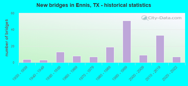
- New bridges - historical statistics
- 41930-1939
- 31940-1949
- 131950-1959
- 81960-1969
- 71970-1979
- 191980-1989
- 511990-1999
- 92000-2009
- 332010-2019
- 72020-2022
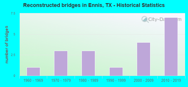
- Reconstructed bridges - Historical Statistics
- 11960-1969
- 31970-1979
- 31980-1989
- 11990-1999
- 42000-2009
- 72010-2019
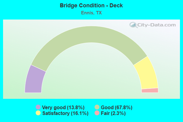
- Bridge Condition - Deck
- 13.8%Very good
- 67.8%Good
- 16.1%Satisfactory
- 2.3%Fair
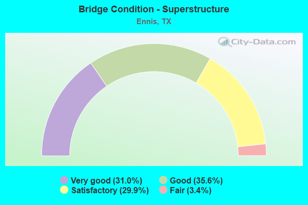
- Bridge Condition - Superstructure
- 31.0%Very good
- 35.6%Good
- 29.9%Satisfactory
- 3.4%Fair
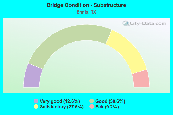
- Bridge Condition - Substructure
- 12.6%Very good
- 50.6%Good
- 27.6%Satisfactory
- 9.2%Fair
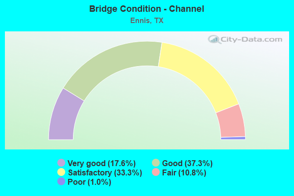
- Bridge Condition - Channel
- 17.6%Very good
- 37.3%Good
- 33.3%Satisfactory
- 10.8%Fair
- 1.0%Poor
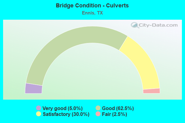
- Bridge Condition - Culverts
- 5.0%Very good
- 62.5%Good
- 30.0%Satisfactory
- 2.5%Fair
Find on map >> Show street view
Structure Number: 18071000920433, Location: 0.8 MI N OF FM 1181 (Lat: 32.334364, Lng: -96.615467), Route carried "under" structure: State highway 34, Year Built: 1997, Structure Length: 0. m, Average Daily Traffic: 7,500 (year 2011), Truck Traffic: 11%, Features Intersected: SH 34, Facility Carried by Structure: IH 45 NB
Minimum Vertical Clearance: 5.23m (17.16ft), Kilometerpoint: 17.619, Lanes on structure: 3, Lanes under structure: 4, Material/Design: Prestressed concrete, Design/Construction: Box Beam or Girders - Multiple, Length of Maximum Span: 29.0m (95.1ft)
Find on map >> Show street view
Structure Number: 180710009204331, Location: 0.8 MI N OF FM 1181 (Lat: 32.334258, Lng: -96.615892), Route carried "under" structure: State highway 34, Year Built: 1998, Structure Length: 0. m, Average Daily Traffic: 3,900 (year 2011), Truck Traffic: 14%, Features Intersected: SH 34, Facility Carried by Structure: IH 45 SB
Minimum Vertical Clearance: 5.13m (16.83ft), Kilometerpoint: 12.928, Lanes on structure: 3, Lanes under structure: 4, Material/Design: Prestressed concrete, Design/Construction: Box Beam or Girders - Multiple, Length of Maximum Span: 29.0m (95.1ft)
Find on map >> Show street view
Structure Number: 180710009204332, Location: 2.2 MI S OF FM 879 (Lat: 32.347719, Lng: -96.624086), Route carried "under" structure: Interstate 45, Year Built: 1997, Structure Length: 0. m, Average Daily Traffic: 37,870 (year 2013), Truck Traffic: 23%, Features Intersected: IH 45, Facility Carried by Structure: CRISP RD
Minimum Vertical Clearance: 5.92m (19.42ft), Kilometerpoint: 14.632, Lanes on structure: 2, Lanes under structure: 10, Material/Design: Prestressed concrete, Design/Construction: Box Beam or Girders - Multiple, Length of Maximum Span: 27.4m (89.9ft)
Find on map >> Show street view
Structure Number: 180710009204333, Location: 1.3 MI S OF FM 879 (Lat: 32.359375, Lng: -96.631878), Route carried "under" structure: Interstate 45, Year Built: 1996, Structure Length: 0. m, Average Daily Traffic: 37,870 (year 2013), Truck Traffic: 23%, Features Intersected: IH 45
Minimum Vertical Clearance: 5.54m (18.18ft), Kilometerpoint: 14.491, Lanes on structure: 2, Lanes under structure: 6, Material/Design: Prestressed concrete, Design/Construction: Box Beam or Girders - Multiple, Length of Maximum Span: 29.0m (95.1ft)
Find on map >> Show street view
Structure Number: 180710009205334, Location: 2.1 MI S OF SH 34 (Lat: 32.310489, Lng: -96.596381), Route carried "under" structure: US 287, Year Built: 1997, Structure Length: 0. m, Average Daily Traffic: 6,900 (year 2011), Truck Traffic: 15%, Features Intersected: FM 85, Facility Carried by Structure: IH 45 NB
Minimum Vertical Clearance: 5.03m (16.50ft), Kilometerpoint: 28.646, Lanes on structure: 3, Lanes under structure: 2, Material/Design: Prestressed concrete, Design/Construction: Stringer/Multi-beam, Length of Maximum Span: 24.4m (80.1ft)
Find on map >> Show street view
Structure Number: 180710009205335, Location: 2.1 MI S OF SH 34 (Lat: 32.310514, Lng: -96.596867), Route carried "under" structure: State highway 85, Year Built: 1998, Structure Length: 0. m, Average Daily Traffic: 7,200 (year 2011), Truck Traffic: 15%, Features Intersected: FM 85, Facility Carried by Structure: IH 45 SB
Minimum Vertical Clearance: 5.28m (17.32ft), Kilometerpoint: 9.724, Lanes on structure: 3, Lanes under structure: 2, Material/Design: Prestressed concrete, Design/Construction: Stringer/Multi-beam, Length of Maximum Span: 24.4m (80.1ft)
Find on map >> Show street view
Structure Number: 180710009205336, Location: 0.8 MI S OF SH 34 (Lat: 32.324683, Lng: -96.608844), Route carried "under" structure: Interstate 45, Year Built: 1996, Structure Length: 0. m, Average Daily Traffic: 37,090 (year 2013), Truck Traffic: 22%, Features Intersected: IH 45, Facility Carried by Structure: FM 1181
Minimum Vertical Clearance: 5.26m (17.26ft), Kilometerpoint: 11.703, Lanes on structure: 2, Lanes under structure: 10, Material/Design: Prestressed concrete, Design/Construction: Box Beam or Girders - Multiple, Length of Maximum Span: 24.4m (80.1ft)
Find on map >> Show street view
Structure Number: 18071001720818, Location: 6.1 MI W OF IH 45 (Lat: 32.317389, Lng: -96.656933), Route carried "under" structure: US 287, Year Built: 1995, Structure Length: 0. m, Average Daily Traffic: 13,820 (year 2013), Truck Traffic: 15%, Features Intersected: US 287, Facility Carried by Structure: ENNIS PKWY
Minimum Vertical Clearance: 5.08m (16.67ft), Kilometerpoint: 0.002, Lanes on structure: 2, Lanes under structure: 4, Material/Design: Prestressed concrete, Design/Construction: Stringer/Multi-beam, Length of Maximum Span: 38.1m (125.0ft)
Find on map >> Show street view
Structure Number: 180710017208182, Location: 4.5 MI W OF IH 45 (Lat: 32.300447, Lng: -96.639161), Route carried "under" structure: State highway 34, Year Built: 1995, Structure Length: 0. m, Average Daily Traffic: 5,550 (year 2011), Features Intersected: SH 34, Facility Carried by Structure: US 287 SB
Minimum Vertical Clearance: 5.13m (16.83ft), Kilometerpoint: 16.095, Lanes on structure: 2, Lanes under structure: 2, Material/Design: Prestressed concrete, Design/Construction: Stringer/Multi-beam, Length of Maximum Span: 27.4m (89.9ft)
Find on map >> Show street view
Structure Number: 180710017208453, Location: 4.5 MI W OF IH 45 (Lat: 32.300364, Lng: -96.638733), Route carried "under" structure: State highway 34, Year Built: 2011, Structure Length: 0. m, Average Daily Traffic: 5,550 (year 2011), Features Intersected: SH 34, Facility Carried by Structure: US 287 NB
Minimum Vertical Clearance: 5.13m (16.83ft), Kilometerpoint: 16.095, Lanes on structure: 2, Lanes under structure: 2, Material/Design: Prestressed concrete, Design/Construction: Stringer/Multi-beam, Length of Maximum Span: 27.4m (89.9ft)
Find on map >> Show street view
Structure Number: 180710017208454, Location: 6.2 MI W OF IH 45 (Lat: 32.319303, Lng: -96.658508), Route carried "under" structure: Business State highway 287, Year Built: 2011, Structure Length: 0. m, Average Daily Traffic: 4,600 (year 2011), Features Intersected: BUS 287 SB
Minimum Vertical Clearance: 5.77m (18.93ft), Kilometerpoint: 7.854, Lanes on structure: 2, Lanes under structure: 2, Material/Design: Prestressed concrete, Design/Construction: Stringer/Multi-beam, Length of Maximum Span: 33.5m (109.9ft)
Find on map >> Show street view
Structure Number: 180710017208455, Location: 0.10 MI S OF US 287 (Lat: 32.319444, Lng: -96.659722), Route carried "under" structure: State highway 287, Year Built: 2013, Structure Length: 0. m, Average Daily Traffic: 300 (year 2013), Truck Traffic: 1%, Features Intersected: LITTLE MUSTANG CREEK
Minimum Vertical Clearance: 5.13m (16.83ft), Kilometerpoint: 0.000, Lanes on structure: 1, Lanes under structure: 2, Material/Design: Prestressed concrete, Design/Construction: Stringer/Multi-beam, Length of Maximum Span: 36.6m (120.1ft)
Find on map >> Show street view
Structure Number: 180710017208457, Location: 0.50 MI NW of SH 34 (Lat: 32.307142, Lng: -96.644633), Route carried "under" structure: State highway 287, Year Built: 2014, Structure Length: 0. m, Average Daily Traffic: 100 (year 2013), Truck Traffic: 1%, Features Intersected: US 287, Facility Carried by Structure: LAMPASAS EB
Minimum Vertical Clearance: 5.16m (16.93ft), Kilometerpoint: 0.000, Lanes on structure: 2, Lanes under structure: 4, Material/Design: Prestressed concrete, Design/Construction: Stringer/Multi-beam, Length of Maximum Span: 39.0m (128.0ft)
Find on map >> Show street view
Structure Number: 180710017208458, Location: 0.50 NI NW of SH 34 (Lat: 32.307533, Lng: -96.644469), Route carried "under" structure: State highway 287, Year Built: 2014, Structure Length: 0. m, Average Daily Traffic: 100 (year 2013), Features Intersected: US 287, Facility Carried by Structure: LAMPASAS WB
Minimum Vertical Clearance: 5.31m (17.42ft), Kilometerpoint: 0.000, Lanes on structure: 2, Lanes under structure: 4, Material/Design: Prestressed concrete, Design/Construction: Stringer/Multi-beam, Length of Maximum Span: 39.0m (128.0ft)
Find on map >> Show street view
Structure Number: 180710017208482, Location: 2.2 MI W OF IH 45 (Lat: 32.289039, Lng: -96.603892), Route carried "under" structure: State highway 1183, Year Built: 2020, Structure Length: 0. m, Average Daily Traffic: 710 (year 2019), Truck Traffic: 7%, Features Intersected: US 287 NB, Facility Carried by Structure: US 287 NB
Minimum Vertical Clearance: 5.05m (16.57ft), Lanes on structure: 2, Lanes under structure: 7, Material/Design: Prestressed concrete, Design/Construction: Stringer/Multi-beam, Length of Maximum Span: 37.8m (124.0ft)
Find on map >> Show street view
Structure Number: 180710017208483, Location: 2.1 MI W OF IH 45 (Lat: 32.288828, Lng: -96.603375), Route carried "under" structure: City street , Year Built: 2019, Structure Length: 0. m, Average Daily Traffic: 500 (year 2018), Truck Traffic: 5%, Features Intersected: US 287 SBML, Facility Carried by Structure: US 287 SBML
Minimum Vertical Clearance: 5.15m (16.90ft), Kilometerpoint: 0.000, Lanes on structure: 2, Lanes under structure: 7, Material/Design: Prestressed concrete, Design/Construction: Stringer/Multi-beam, Length of Maximum Span: 37.8m (124.0ft)
Find on map >> Show street view
Structure Number: 180710017208484, Location: 3.2 MI W OF IH 45 (Lat: 32.289728, Lng: -96.621761), Route carried "under" structure: City street , Year Built: 2020, Structure Length: 0. m, Average Daily Traffic: 4,753 (year 2019), Truck Traffic: 3%, Features Intersected: US 287 NB, Facility Carried by Structure: US 287 NB
Minimum Vertical Clearance: 5.13m (16.83ft), Lanes on structure: 2, Lanes under structure: 7, Material/Design: Prestressed concrete, Design/Construction: Stringer/Multi-beam, Length of Maximum Span: 32.9m (107.9ft)
Find on map >> Show street view
Structure Number: 180710017208485, Location: 1.3 MI W OF IH 45 (Lat: 32.289247, Lng: -96.589967), Route carried "under" structure: City street , Year Built: 2020, Structure Length: 0. m, Average Daily Traffic: 1,141 (year 2019), Truck Traffic: 3%, Features Intersected: US 287 NB, Facility Carried by Structure: US 287 NB
Minimum Vertical Clearance: 5.11m (16.77ft), Lanes on structure: 2, Lanes under structure: 6, Material/Design: Prestressed concrete, Design/Construction: Stringer/Multi-beam, Length of Maximum Span: 36.6m (120.1ft)
Find on map >> Show street view
Structure Number: 180710017208486, Location: 0.8 MI W OF IH 45 (Lat: 32.289019, Lng: -96.589839), Route carried "under" structure: City street , Year Built: 2019, Structure Length: 0. m, Average Daily Traffic: 500 (year 2018), Truck Traffic: 5%, Features Intersected: US 287 SBML, Facility Carried by Structure: US 287 SBML
Minimum Vertical Clearance: 6.07m (19.91ft), Kilometerpoint: 0.000, Lanes on structure: 2, Lanes under structure: 6, Material/Design: Prestressed concrete, Design/Construction: Stringer/Multi-beam, Length of Maximum Span: 36.6m (120.1ft)
Find on map >> Show street view
Structure Number: 180710017208487, Location: 3.2 MI W OF IH 45 (Lat: 32.289533, Lng: -96.621819), Route carried "under" structure: City street , Year Built: 2019, Structure Length: 0. m, Average Daily Traffic: 500 (year 2018), Truck Traffic: 5%, Features Intersected: US 287 SBML, Facility Carried by Structure: US 287 SBML
Minimum Vertical Clearance: 6.04m (19.82ft), Kilometerpoint: 0.000, Lanes on structure: 2, Lanes under structure: 7, Material/Design: Prestressed concrete, Design/Construction: Stringer/Multi-beam, Length of Maximum Span: 32.9m (107.9ft)
Find on map >> Show street view
Structure Number: 180710017212179, Location: 6.2 MI W OF IH 45 (Lat: 32.319772, Lng: -96.659836), Route carried "under" structure: Business State highway 287, Year Built: 1995, Structure Length: 0. m, Average Daily Traffic: 4,600 (year 2011), Features Intersected: BUS 287 SB
Minimum Vertical Clearance: 5.21m (17.09ft), Kilometerpoint: 7.854, Lanes on structure: 2, Lanes under structure: 2, Material/Design: Prestressed concrete, Design/Construction: Stringer/Multi-beam, Length of Maximum Span: 34.1m (111.9ft)
Find on map >> Show street view
Structure Number: 180710017212361, Location: 0.05 MI W OF IH 45 (Lat: 32.296967, Lng: -96.572711), Route carried "under" structure: ServiceInterstate 45, Year Built: 1995, Structure Length: 0. m, Average Daily Traffic: 30,000 (year 2011), Features Intersected: SPRR & IH 45 SBFR, Facility Carried by Structure: US 287 CONN W-N
Minimum Vertical Clearance: 7.11m (23.33ft), Kilometerpoint: 7.133, Lanes on structure: 1, Lanes under structure: 4, Material/Design: Prestressed concrete, Design/Construction: Stringer/Multi-beam, Length of Maximum Span: 34.7m (113.8ft)
Find on map >> Show street view
Structure Number: 180710017212362, Location: 0.05 MI W OF IH 45 (Lat: 32.296294, Lng: -96.571489), Route carried "under" structure: ServiceInterstate 45, Year Built: 1995, Structure Length: 0. m, Average Daily Traffic: 30,000 (year 2011), Features Intersected: SPRR & IH 45 SBFR, Facility Carried by Structure: US 287 CONN W-S
Minimum Vertical Clearance: 8.61m (28.25ft), Kilometerpoint: 7.133, Lanes on structure: 1, Lanes under structure: 4, Material/Design: Prestressed concrete, Design/Construction: Stringer/Multi-beam, Length of Maximum Span: 35.1m (115.2ft)
Find on map >> Show street view
Structure Number: 180710017212363, Location: 0.05 MI W OF IH 45 (Lat: 32.296583, Lng: -96.571831), Route carried "under" structure: ServiceInterstate 45, Year Built: 1995, Structure Length: 0. m, Average Daily Traffic: 30,000 (year 2011), Features Intersected: SPRR & IH 45 SBFR, Facility Carried by Structure: US 287 NB
Minimum Vertical Clearance: 8.43m (27.66ft), Kilometerpoint: 7.133, Lanes on structure: 1, Lanes under structure: 4, Material/Design: Prestressed concrete, Design/Construction: Stringer/Multi-beam, Length of Maximum Span: 29.0m (95.1ft)
Find on map >> Show street view
Structure Number: 180710017212364, Location: 0.05 MI W OF IH 45 (Lat: 32.296489, Lng: -96.571650), Route carried "under" structure: ServiceInterstate 45, Year Built: 1995, Structure Length: 0. m, Average Daily Traffic: 30,000 (year 2011), Features Intersected: SPRR & IH 45 SBFR, Facility Carried by Structure: US 287 SB
Minimum Vertical Clearance: 8.74m (28.67ft), Kilometerpoint: 7.133, Lanes on structure: 1, Lanes under structure: 4, Material/Design: Prestressed concrete, Design/Construction: Stringer/Multi-beam, Length of Maximum Span: 29.0m (95.1ft)
Find on map >> Show street view
Structure Number: 180710017212367, Location: US 287 AT IH 45 (Lat: 32.297881, Lng: -96.569658), Route carried "under" structure: Interstate 45, Year Built: 1995, Structure Length: 0. m, Average Daily Traffic: 30,000 (year 2011), Features Intersected: IH 45, Facility Carried by Structure: US 287 NB
Minimum Vertical Clearance: 9.17m (30.09ft), Kilometerpoint: 7.133, Lanes on structure: 1, Lanes under structure: 6, Material/Design: Prestressed concrete, Design/Construction: Stringer/Multi-beam, Length of Maximum Span: 32.3m (106.0ft)
Find on map >> Show street view
Structure Number: 180710017212368, Location: US 287 AT IH 45 (Lat: 32.297747, Lng: -96.569369), Route carried "under" structure: Interstate 45, Year Built: 1995, Structure Length: 0. m, Average Daily Traffic: 30,000 (year 2011), Features Intersected: IH 45, Facility Carried by Structure: US 287 SB
Minimum Vertical Clearance: 9.07m (29.76ft), Kilometerpoint: 7.133, Lanes on structure: 1, Lanes under structure: 6, Material/Design: Prestressed concrete, Design/Construction: Stringer/Multi-beam, Length of Maximum Span: 32.3m (106.0ft)