Bridge Statistics for Edmore, Michigan (MI)
Condition, Traffic, Stress, Structural Evaluation, Project Costs
- National Bridge Inventory (NBI) Statistics
- 40Number of bridges
- 387ft / 118mTotal length
- $415,000Total costs
- 257,195Total average daily traffic
- 20,582Total average daily truck traffic
- 337,476Total future (year 1977) average daily traffic
- National Bridge Inventory (NBI) Registered Bridges for Edmore
- No street view available for this location
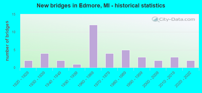
- New bridges - historical statistics
- 21920-1929
- 41930-1939
- 21940-1949
- 11950-1959
- 121960-1969
- 41970-1979
- 51980-1989
- 31990-1999
- 22000-2009
- 32010-2019
- 22020-2022

- Reconstructed bridges - Historical Statistics
- 31980-1989
- 31990-1999
- 12000-2009


- Bridge Condition - Deck
- 5.6%Excellent
- 5.6%Very good
- 47.2%Good
- 30.6%Satisfactory
- 8.3%Fair
- 2.8%Serious

- Bridge Condition - Superstructure
- 5.6%Excellent
- 13.9%Very good
- 30.6%Good
- 36.1%Satisfactory
- 11.1%Fair
- 2.8%Serious

- Bridge Condition - Substructure
- 2.8%Excellent
- 13.9%Very good
- 36.1%Good
- 41.7%Satisfactory
- 5.6%Fair

- Bridge Condition - Channel
- 3.2%Excellent
- 19.4%Very good
- 22.6%Good
- 41.9%Satisfactory
- 9.7%Fair
- 3.2%Poor

- Bridge Condition - Culverts
- 25.0%Excellent
- 25.0%Very good
- 25.0%Good
- 25.0%Satisfactory
Find on map >> Show street view
Structure Number: 128, Location: 6.0 MI SW OF OTTAWA COL (Lat: 42.733800, Lng: -86.136203), Route carried "on" structure: County highway , Year Built: 1972, Status: Open, Structure Length: 10.06m (33.01ft), Average Daily Traffic: 1,877 (year 1997), Truck Traffic: 3%, Average Future Daily Traffic: 2,158 (year 2017), Design Load: H 20, Features Intersected: I-196, Facility Carried by Structure: 60 TH STREET
Minimum Vertical Clearance: 30.48m (100.00ft), Kilometerpoint: 9.700, Lanes on structure: 2, Lanes under structure: 4, Owner: State Highway Agency, Approaching Roadway Width: 9.4m (30.8ft), Skew: 1 degrees, Material/Design: Steel, Design/Construction: Stringer/Multi-beam, Number Of Spans In Main Unit: 5, Length of Maximum Span: 28.3m (92.8ft), Curb or Sidewalk Widths: Left: 0.1m (0.3ft), Right: 0.1m (0.3ft), Curb-To-Curb Width: 12.3m (40.4ft), Out-to-Out Width: 13.5m (44.3ft)
Condition: Deck: Satisfactory, Superstructure: Good, Substructure: Satisfactory, Operating Rating: 61.9 metric tons, Method Used To Determine Operating Rating: Load Factor (LF) rating reported by rating factor (RF) method using MS18 loading, Inventory Rating: 36.9 metric tons, Method Used To Determine Inventory Rating: Load Factor (LF) rating reported by rating factor (RF) method using MS18 loading, Structural Evaluation: Equal to present minimum criteria, Deck Geometry: Better than present minimum criteria, Underclear: Somewhat better than minimum adequacy, Approach Roadway Alignment: Equal to present minimum criteria, Designated Inspection Frequency: Every 24 months, Inspection Date: May 2021, Deck Structure Type: Concrete Cast-file-Place, Wearing Surface/Protective System: Wearing Surface: Monolithic Concrete
Find on map >> Show street view
Structure Number: 129, Location: 4.9 MI SW OF OTTAWA COL (Lat: 42.736428, Lng: -86.115753), Route carried "on" structure: County highway 303, Year Built: 1972, Year Reconstructed: 2014, Status: Open, Structure Length: 7.62m (25.00ft), Average Daily Traffic: 7,959 (year 1997), Truck Traffic: 3%, Average Future Daily Traffic: 9,252 (year 2017), Design Load: H 20, Features Intersected: I-196, Facility Carried by Structure: 58 TH STREET
Minimum Vertical Clearance: 30.48m (100.00ft), Kilometerpoint: 20.335, Lanes on structure: 2, Lanes under structure: 4, Owner: State Highway Agency, Approaching Roadway Width: 10.4m (34.1ft), Material/Design: Steel continuous, Design/Construction: Stringer/Multi-beam, Number Of Spans In Main Unit: 2, Length of Maximum Span: 37.7m (123.7ft), Curb-To-Curb Width: 13.6m (44.6ft), Out-to-Out Width: 14.8m (48.6ft)
Condition: Deck: Satisfactory, Superstructure: Good, Substructure: Good, Operating Rating: 71.0 metric tons, Method Used To Determine Operating Rating: Load Factor (LF) rating reported by rating factor (RF) method using MS18 loading, Inventory Rating: 42.4 metric tons, Method Used To Determine Inventory Rating: Load Factor (LF) rating reported by rating factor (RF) method using MS18 loading, Structural Evaluation: Better than present minimum criteria, Deck Geometry: Superior to present desirable criteria, Underclear: Somewhat better than minimum adequacy, Approach Roadway Alignment: Equal to present desirable criteria, Designated Inspection Frequency: Every 24 months, Inspection Date: May 2021, Deck Structure Type: Concrete Cast-file-Place, Wearing Surface/Protective System: Wearing Surface: Latex Concrete
Find on map >> Show street view
Structure Number: 382, Location: 2.0 MI SW OF STANDISH (Lat: 43.950522, Lng: -83.966639), Route carried "on" structure: US 23, Year Built: 1968, Status: Open, Structure Length: 5.27m (17.29ft), Average Daily Traffic: 4,566 (year 2007), Truck Traffic: 9%, Average Future Daily Traffic: 5,250 (year 2015), Design Load: HS 25 or greater, Features Intersected: M-13
Minimum Vertical Clearance: 4.47m (14.67ft), Kilometerpoint: 3.895, Lanes on structure: 2, Lanes under structure: 4, Base Highway Network: Yes (Inventory Route: 106, Subroute: 7), Owner: State Highway Agency, Approaching Roadway Width: 12.2m (40.0ft), Material/Design: Prestressed concrete, Design/Construction: Stringer/Multi-beam, Number Of Spans In Main Unit: 4, Length of Maximum Span: 16.3m (53.5ft), Curb-To-Curb Width: 11.9m (39.0ft), Out-to-Out Width: 13.2m (43.3ft)
Condition: Deck: Good, Superstructure: Satisfactory, Substructure: Good, Operating Rating: 54.8 metric tons, Method Used To Determine Operating Rating: Load Factor (LF), Inventory Rating: 32.8 metric tons, Method Used To Determine Inventory Rating: Load Factor (LF), Structural Evaluation: Equal to present minimum criteria, Deck Geometry: Better than present minimum criteria, Underclear: Somewhat better than minimum adequacy, Approach Roadway Alignment: Equal to present desirable criteria, Designated Inspection Frequency: Every 24 months, Inspection Date: September 2020, Deck Structure Type: Concrete Cast-file-Place, Wearing Surface/Protective System: Wearing Surface: Epoxy Overlay, Deck Protection: Epoxy Coated Reinforcing
Find on map >> Show street view
Structure Number: 383, Location: 4.0 MI S OF STANDISH (Lat: 43.926661, Lng: -83.966533), Route carried "on" structure: State highway 13, Year Built: 1937, Year Reconstructed: 1998, Status: Open, Structure Length: 2.53m (8.30ft), Average Daily Traffic: 7,706 (year 2007), Truck Traffic: 6%, Average Future Daily Traffic: 8,753 (year 2018), Design Load: HS 25 or greater, Features Intersected: SAGANING CREEK
Minimum Vertical Clearance: 30.48m (100.00ft), Kilometerpoint: 1.775, Lanes on structure: 4, Base Highway Network: Yes (Inventory Route: 106, Subroute: 1), Owner: State Highway Agency, Approaching Roadway Width: 20.4m (66.9ft), Skew: 20 degrees, Material/Design: Prestressed concrete, Design/Construction: Box Beam or Girders - Multiple, Number Of Spans In Main Unit: 3, Length of Maximum Span: 10.0m (32.8ft), Curb-To-Curb Width: 20.4m (66.9ft), Out-to-Out Width: 21.3m (69.9ft)
Condition: Deck: Satisfactory, Superstructure: Good, Substructure: Good, Channel: Satisfactory, Operating Rating: 87.2 metric tons, Method Used To Determine Operating Rating: Load Factor (LF) rating reported by rating factor (RF) method using MS18 loading, Inventory Rating: 44.1 metric tons, Method Used To Determine Inventory Rating: Load Factor (LF) rating reported by rating factor (RF) method using MS18 loading, Structural Evaluation: Better than present minimum criteria, Deck Geometry: Superior to present desirable criteria, Waterway Adequacy: Better than present minimum criteria, Approach Roadway Alignment: Equal to present desirable criteria, Designated Inspection Frequency: Every 24 months, Inspection Date: June 2020, Deck Structure Type: Concrete Cast-file-Place, Wearing Surface/Protective System: Wearing Surface: Monolithic Concrete, Deck Protection: Epoxy Coated Reinforcing
Find on map >> Show street view
Structure Number: 384, Location: 3.0 MI S OF STANDISH (Lat: 43.944569, Lng: -83.966625), Route carried "on" structure: State highway 13, Year Built: 1935, Year Reconstructed: 1998, Status: Open, Structure Length: 2.92m (9.58ft), Average Daily Traffic: 7,706 (year 2007), Truck Traffic: 6%, Average Future Daily Traffic: 8,753 (year 2018), Design Load: H 20, Features Intersected: S BR PINE RIVER
Minimum Vertical Clearance: 30.48m (100.00ft), Kilometerpoint: 3.508, Lanes on structure: 4, Base Highway Network: Yes (Inventory Route: 106, Subroute: 1), Owner: State Highway Agency, Approaching Roadway Width: 21.3m (69.9ft), Skew: 20 degrees, Material/Design: Steel, Design/Construction: Stringer/Multi-beam, Number Of Spans In Main Unit: 3, Length of Maximum Span: 9.7m (31.8ft), Curb-To-Curb Width: 21.0m (68.9ft), Out-to-Out Width: 22.1m (72.5ft)
Condition: Deck: Good, Superstructure: Satisfactory, Substructure: Satisfactory, Channel: Satisfactory, Operating Rating: 90.7 metric tons, Method Used To Determine Operating Rating: Load Factor (LF) rating reported by rating factor (RF) method using MS18 loading, Inventory Rating: 54.4 metric tons, Method Used To Determine Inventory Rating: Load Factor (LF) rating reported by rating factor (RF) method using MS18 loading, Structural Evaluation: Equal to present minimum criteria, Deck Geometry: Superior to present desirable criteria, Waterway Adequacy: Equal to present minimum criteria, Approach Roadway Alignment: Equal to present desirable criteria, Designated Inspection Frequency: Every 24 months, Inspection Date: June 2020, Deck Structure Type: Concrete Cast-file-Place, Wearing Surface/Protective System: Wearing Surface: Monolithic Concrete, Deck Protection: Epoxy Coated Reinforcing
Find on map >> Show street view
Structure Number: 403, Location: 2.0 MI S OF TWINING (Lat: 44.084192, Lng: -83.806761), Route carried "on" structure: State highway 65, Year Built: 2021, Status: Open, Structure Length: 0.86m (2.82ft), Average Daily Traffic: 4,353 (year 2018), Truck Traffic: 4%, Average Future Daily Traffic: 5,006 (year 2038), Design Load: Greater than HL93, Features Intersected: BIG CREEK
Minimum Vertical Clearance: 30.48m (100.00ft), Kilometerpoint: 9.458, Lanes on structure: 2, Base Highway Network: Yes (Inventory Route: 106, Subroute: 8), Owner: State Highway Agency, Approaching Roadway Width: 12.8m (42.0ft), Material/Design: Concrete, Design/Construction: Culvert, Number Of Spans In Main Unit: 1, Length of Maximum Span: 8.6m (28.2ft)
Condition: Channel: Excellent, Culverts: Excellent, Operating Rating: 58.3 metric tons, Method Used To Determine Operating Rating: Load and Resistance Factor Rating (LRFR) rating reported by rating factor(RF) method using HL-93 loadings, Inventory Rating: 45.0 metric tons, Method Used To Determine Inventory Rating: Load and Resistance Factor Rating (LRFR) rating reported by rating factor(RF) method using HL-93 loadings, Structural Evaluation: Superior to present desirable criteria, Waterway Adequacy: Somewhat better than minimum adequacy, Approach Roadway Alignment: Somewhat better than minimum adequacy, Length Of Structure Improvement: 0.82m (2.69ft), Designated Inspection Frequency: Every 24 months, Inspection Date: January 2022, Bridge Improvement Cost: $4,000, Total Project Cost: $4,000, Wearing Surface/Protective System: Wearing Surface: Low Slump Concrete
Find on map >> Show street view
Structure Number: 764, Location: 2.6 MI EAST OF FRANKFORT (Lat: 44.618303, Lng: -86.167664), Route carried "on" structure: County highway 1040, Year Built: 1960, Status: Open, Structure Length: 2.13m (6.99ft), Average Daily Traffic: 1,329 (year 2008), Truck Traffic: 10%, Average Future Daily Traffic: 1,734 (year 2018), Design Load: HS 20, Features Intersected: BETSIE RIVER, Facility Carried by Structure: RIVER ROAD
Minimum Vertical Clearance: 30.48m (100.00ft), Kilometerpoint: 4.558, Lanes on structure: 2, Owner: County Highway Agency, Approaching Roadway Width: 9.8m (32.2ft), Material/Design: Prestressed concrete, Design/Construction: Box Beam or Girders - Multiple, Number Of Spans In Main Unit: 2, Length of Maximum Span: 10.3m (33.8ft), Curb-To-Curb Width: 7.3m (24.0ft), Out-to-Out Width: 7.3m (24.0ft)
Condition: Deck: Good, Superstructure: Good, Substructure: Satisfactory, Channel: Satisfactory, Operating Rating: 54.5 metric tons, Method Used To Determine Operating Rating: Field evaluation and documented engineering judgment, Inventory Rating: 32.7 metric tons, Method Used To Determine Inventory Rating: Field evaluation and documented engineering judgment, Structural Evaluation: Equal to present minimum criteria, Deck Geometry: Meets minimum limits, Waterway Adequacy: Equal to present desirable criteria, Approach Roadway Alignment: Equal to present desirable criteria, Designated Inspection Frequency: Every 24 months, Inspection Date: August 2020, Deck Structure Type: Concrete Precast Panels, Wearing Surface/Protective System: Wearing Surface: Bituminous, Deck Protection: Bituminous
Find on map >> Show street view
Structure Number: 875, Location: 0.3 MI NW OF SCOTTDALE (Lat: 42.044350, Lng: -86.440078), Route carried "on" structure: State highway 63, Year Built: 1949, Status: Open, Structure Length: 1.00m (3.28ft), Average Daily Traffic: 8,157 (year 2007), Truck Traffic: 5%, Average Future Daily Traffic: 15,140 (year 2018), Design Load: H 20, Features Intersected: BIG MEADOW DRAIN
Minimum Vertical Clearance: 30.48m (100.00ft), Kilometerpoint: 15.127, Lanes on structure: 2, Base Highway Network: Yes (Inventory Route: 311, Subroute: 92), Owner: State Highway Agency, Approaching Roadway Width: 11.0m (36.1ft), Material/Design: Concrete, Design/Construction: Tee Beam, Number Of Spans In Main Unit: 1, Length of Maximum Span: 10.0m (32.8ft), Curb-To-Curb Width: 13.0m (42.7ft), Out-to-Out Width: 22.3m (73.2ft)
Condition: Deck: Good, Superstructure: Satisfactory, Substructure: Satisfactory, Channel: Fair, Operating Rating: 77.8 metric tons, Method Used To Determine Operating Rating: Load Factor (LF) rating reported by rating factor (RF) method using MS18 loading, Inventory Rating: 46.7 metric tons, Method Used To Determine Inventory Rating: Load Factor (LF) rating reported by rating factor (RF) method using MS18 loading, Structural Evaluation: Equal to present minimum criteria, Deck Geometry: Somewhat better than minimum adequacy, Waterway Adequacy: Equal to present desirable criteria, Approach Roadway Alignment: Equal to present desirable criteria, Designated Inspection Frequency: Every 24 months, Inspection Date: April 2020, Deck Structure Type: Concrete Cast-file-Place, Wearing Surface/Protective System: Wearing Surface: Bituminous
Find on map >> Show street view
Structure Number: 387, Location: 2.5 MILES SE OF DIMONDALE (Lat: 42.621839, Lng: -84.602728), Route carried "on" structure: County highway 3305, Year Built: 1961, Year Reconstructed: 2021, Status: Open, Structure Length: 6.22m (20.41ft), Average Daily Traffic: 3,010 (year 2019), Truck Traffic: 2%, Average Future Daily Traffic: 3,680 (year 2039), Design Load: HS 20, Features Intersected: GRAND RIVER, Facility Carried by Structure: WAVERLY ROAD
Minimum Vertical Clearance: 30.48m (100.00ft), Kilometerpoint: 4.458, Lanes on structure: 2, Owner: County Highway Agency, Approaching Roadway Width: 7.3m (24.0ft), Skew: 2 degrees, Material/Design: Prestressed concrete, Design/Construction: Box Beam or Girders - Single/Spread, Number Of Spans In Main Unit: 4, Length of Maximum Span: 15.1m (49.5ft), Curb-To-Curb Width: 8.5m (27.9ft), Out-to-Out Width: 8.9m (29.2ft)
Condition: Deck: Excellent, Superstructure: Excellent, Substructure: Good, Channel: Good, Operating Rating: 68.4 metric tons, Method Used To Determine Operating Rating: Load and Resistance Factor Rating (LRFR) rating reported by rating factor(RF) method using HL-93 loadings, Inventory Rating: 52.8 metric tons, Method Used To Determine Inventory Rating: Load and Resistance Factor Rating (LRFR) rating reported by rating factor(RF) method using HL-93 loadings, Structural Evaluation: Better than present minimum criteria, Deck Geometry: Meets minimum limits, Waterway Adequacy: Equal to present desirable criteria, Approach Roadway Alignment: Equal to present desirable criteria, Length Of Structure Improvement: 6.22m (20.41ft), Designated Inspection Frequency: Every 19 months, Inspection Date: December 2021, Bridge Improvement Cost: $328,000, Roadway Improvement Cost: $83,000, Total Project Cost: $411,000, Deck Structure Type: Concrete Cast-file-Place, Wearing Surface/Protective System: Wearing Surface: Monolithic Concrete, Deck Protection: Epoxy Coated Reinforcing
Find on map >> Show street view
Structure Number: 4019, Location: 6.9MI W M66 ON GR RIV AVE (Lat: 42.886789, Lng: -85.204997), Route carried "on" structure: ServiceCounty highway , Year Built: 1926, Status: Open, Structure Length: 0.70m (2.30ft), Average Daily Traffic: 1,196 (year 2007), Truck Traffic: 18%, Average Future Daily Traffic: 1,392 (year 2027), Design Load: HS 20+Mod, Features Intersected: LAKE CREEK, Facility Carried by Structure: GRAND RIVER AVENUE
Minimum Vertical Clearance: 30.48m (100.00ft), Kilometerpoint: 8.745, Lanes on structure: 2, Owner: County Highway Agency, Approaching Roadway Width: 11.0m (36.1ft), Material/Design: Concrete, Design/Construction: Tee Beam, Number Of Spans In Main Unit: 1, Length of Maximum Span: 6.1m (20.0ft), Curb-To-Curb Width: 11.0m (36.1ft), Out-to-Out Width: 11.6m (38.1ft)
Condition: Deck: Fair, Superstructure: Fair, Substructure: Fair, Channel: Satisfactory, Operating Rating: 50.5 metric tons, Method Used To Determine Operating Rating: Load Factor (LF) rating reported by rating factor (RF) method using MS18 loading, Inventory Rating: 30.1 metric tons, Method Used To Determine Inventory Rating: Load Factor (LF) rating reported by rating factor (RF) method using MS18 loading, Structural Evaluation: Somewhat better than minimum adequacy, Deck Geometry: Equal to present minimum criteria, Waterway Adequacy: Better than present minimum criteria, Approach Roadway Alignment: Somewhat better than minimum adequacy, Designated Inspection Frequency: Every 24 months, Inspection Date: October 2021, Deck Structure Type: Concrete Cast-file-Place, Wearing Surface/Protective System: Wearing Surface: Bituminous
Find on map >> Show street view
Structure Number: 4021, Location: 3.85 MI EAST OF SARANAC (Lat: 42.929631, Lng: -85.121394), Route carried "on" structure: ServiceCounty highway 3444, Year Built: 1930, Status: Posted for load, Structure Length: 0.82m (2.69ft), Average Daily Traffic: 1,537 (year 2007), Truck Traffic: 13%, Average Future Daily Traffic: 1,788 (year 2027), Design Load: HS 20+Mod, Features Intersected: SESSIONS CREEK, Facility Carried by Structure: DAVID HWY
Minimum Vertical Clearance: 30.48m (100.00ft), Kilometerpoint: 7.902, Lanes on structure: 2, Owner: County Highway Agency, Approaching Roadway Width: 9.1m (29.9ft), Material/Design: Concrete, Design/Construction: Tee Beam, Number Of Spans In Main Unit: 1, Length of Maximum Span: 7.3m (24.0ft), Curb-To-Curb Width: 7.9m (25.9ft), Out-to-Out Width: 8.6m (28.2ft)
Condition: Deck: Good, Superstructure: Fair, Substructure: Satisfactory, Channel: Satisfactory, Operating Rating: 40.2 metric tons, Method Used To Determine Operating Rating: Load Factor (LF) rating reported by rating factor (RF) method using MS18 loading, Inventory Rating: 24.0 metric tons, Method Used To Determine Inventory Rating: Load Factor (LF) rating reported by rating factor (RF) method using MS18 loading, Structural Evaluation: Somewhat better than minimum adequacy, Deck Geometry: Meets minimum limits, Waterway Adequacy: Better than present minimum criteria, Approach Roadway Alignment: Equal to present minimum criteria, Bridge Posting: Required (Relationship of Operating Rating to Maximum Legal Load: 10.0 - 19.9% below), Designated Inspection Frequency: Every 24 months, Inspection Date: October 2021, Deck Structure Type: Concrete Cast-file-Place, Wearing Surface/Protective System: Wearing Surface: Bituminous
Find on map >> Show street view
Structure Number: 4022, Location: 2 MI S OF IONIA 4.6 MI E (Lat: 42.929258, Lng: -84.981939), Route carried "on" structure: ServiceCounty highway 3444, Year Built: 2016, Status: Open, Structure Length: 1.68m (5.51ft), Average Daily Traffic: 1,550 (year 2015), Truck Traffic: 9%, Average Future Daily Traffic: 2,305 (year 2035), Design Load: Greater than HL93, Features Intersected: LIBHART CREEK, Facility Carried by Structure: DAVID HWY
Minimum Vertical Clearance: 30+ m (98+ ft), Kilometerpoint: 19.285, Lanes on structure: 2, Owner: County Highway Agency, Approaching Roadway Width: 10.4m (34.1ft), Skew: 1 degrees, Material/Design: Prestressed concrete, Design/Construction: Stringer/Multi-beam, Number Of Spans In Main Unit: 1, Length of Maximum Span: 15.9m (52.2ft), Curb-To-Curb Width: 10.4m (34.1ft), Out-to-Out Width: 11.2m (36.7ft)
Condition: Deck: Very good, Superstructure: Very good, Substructure: Very good, Channel: Very good, Operating Rating: 74.5 metric tons, Method Used To Determine Operating Rating: Load and Resistance Factor Rating (LRFR) rating reported by rating factor(RF) method using HL-93 loadings, Inventory Rating: 57.7 metric tons, Method Used To Determine Inventory Rating: Load and Resistance Factor Rating (LRFR) rating reported by rating factor(RF) method using HL-93 loadings, Structural Evaluation: Equal to present desirable criteria, Deck Geometry: Equal to present minimum criteria, Waterway Adequacy: Superior to present desirable criteria, Approach Roadway Alignment: Equal to present desirable criteria, Designated Inspection Frequency: Every 24 months, Inspection Date: October 2021, Deck Structure Type: Concrete Cast-file-Place, Wearing Surface/Protective System: Wearing Surface: Monolithic Concrete, Deck Protection: Epoxy Coated Reinforcing
Find on map >> Show street view
Structure Number: 4023, Location: SECTION 6 PORTLAND TWP (Lat: 42.929144, Lng: -84.948311), Route carried "on" structure: ServiceCounty highway 3444, Year Built: 1992, Status: Open, Structure Length: 0.64m (2.10ft), Average Daily Traffic: 1,381 (year 2007), Truck Traffic: 10%, Average Future Daily Traffic: 1,607 (year 2027), Design Load: HS 20+Mod, Features Intersected: CARBAUGH-E LIBBART DRAIN, Facility Carried by Structure: DAVID HIGHWAY
Minimum Vertical Clearance: 30.48m (100.00ft), Kilometerpoint: 22.029, Lanes on structure: 2, Owner: County Highway Agency, Approaching Roadway Width: 10.1m (33.1ft), Material/Design: Steel, Design/Construction: Culvert, Number Of Spans In Main Unit: 2, Length of Maximum Span: 2.7m (8.9ft)
Condition: Channel: Fair, Culverts: Satisfactory, Operating Rating: 97.2 metric tons, Method Used To Determine Operating Rating: Load Factor (LF) rating reported by rating factor (RF) method using MS18 loading, Inventory Rating: 97.2 metric tons, Method Used To Determine Inventory Rating: Load Factor (LF) rating reported by rating factor (RF) method using MS18 loading, Structural Evaluation: Equal to present minimum criteria, Waterway Adequacy: Better than present minimum criteria, Approach Roadway Alignment: Equal to present desirable criteria, Designated Inspection Frequency: Every 24 months, Inspection Date: October 2021
Find on map >> Show street view
Structure Number: 4024, Location: 4 MI N PORTLAND DAVID HWY (Lat: 42.929511, Lng: -84.895553), Route carried "on" structure: ServiceCounty highway 3444, Year Built: 1968, Status: Open, Structure Length: 8.53m (27.99ft), Average Daily Traffic: 1,900 (year 2015), Truck Traffic: 8%, Average Future Daily Traffic: 3,400 (year 2035), Design Load: HS 20+Mod, Features Intersected: GRAND RIVER, Facility Carried by Structure: DAVID HIGHWAY
Minimum Vertical Clearance: 30.48m (100.00ft), Kilometerpoint: 26.336, Lanes on structure: 2, Owner: County Highway Agency, Approaching Roadway Width: 10.1m (33.1ft), Material/Design: Steel, Design/Construction: Stringer/Multi-beam, Number Of Spans In Main Unit: 4, Length of Maximum Span: 21.1m (69.2ft), Curb-To-Curb Width: 9.0m (29.5ft), Out-to-Out Width: 10.2m (33.5ft)
Condition: Deck: Good, Superstructure: Very good, Substructure: Satisfactory, Channel: Satisfactory, Operating Rating: 91.2 metric tons, Method Used To Determine Operating Rating: Load Factor (LF), Inventory Rating: 54.6 metric tons, Method Used To Determine Inventory Rating: Load Factor (LF), Structural Evaluation: Equal to present minimum criteria, Deck Geometry: Somewhat better than minimum adequacy, Waterway Adequacy: Better than present minimum criteria, Approach Roadway Alignment: Better than present minimum criteria, Designated Inspection Frequency: Every 24 months, Underwater Inspection Frequency: Every 60 months, Inspection Date: October 2021, Underwater Inspection Date: October 2021, Deck Structure Type: Concrete Cast-file-Place, Wearing Surface/Protective System: Wearing Surface: Epoxy Overlay
Find on map >> Show street view
Structure Number: 4025, Location: 3.98 MI NE OF SARANAC (Lat: 42.955497, Lng: -85.126836), Route carried "on" structure: ServiceCounty highway , Year Built: 1963, Status: Posted for load, Structure Length: 1.22m (4.00ft), Average Daily Traffic: 1,348 (year 2007), Truck Traffic: 4%, Average Future Daily Traffic: 1,568 (year 2027), Design Load: HS 20+Mod, Features Intersected: SESSIONS CREEK, Facility Carried by Structure: WEST RIVERSIDE DR
Minimum Vertical Clearance: 30.48m (100.00ft), Kilometerpoint: 7.907, Lanes on structure: 2, Owner: County Highway Agency, Approaching Roadway Width: 9.1m (29.9ft), Skew: 1 degrees, Material/Design: Prestressed concrete, Design/Construction: Box Beam or Girders - Multiple, Number Of Spans In Main Unit: 1, Length of Maximum Span: 10.6m (34.8ft), Curb or Sidewalk Widths: Left: 0.4m (1.3ft), Right: 0.4m (1.3ft), Curb-To-Curb Width: 7.9m (25.9ft), Out-to-Out Width: 9.7m (31.8ft)
Condition: Deck: Satisfactory, Superstructure: Fair, Substructure: Satisfactory, Channel: Poor, Operating Rating: 45.4 metric tons, Method Used To Determine Operating Rating: Load Factor (LF) rating reported by rating factor (RF) method using MS18 loading, Inventory Rating: 27.2 metric tons, Method Used To Determine Inventory Rating: Load Factor (LF) rating reported by rating factor (RF) method using MS18 loading, Structural Evaluation: Somewhat better than minimum adequacy, Deck Geometry: Meets minimum limits, Waterway Adequacy: Better than present minimum criteria, Approach Roadway Alignment: Better than present minimum criteria, Bridge Posting: Required (Relationship of Operating Rating to Maximum Legal Load: 0.1 - 9.9% below), Designated Inspection Frequency: Every 12 months, Inspection Date: October 2021, Deck Structure Type: Concrete Precast Panels, Wearing Surface/Protective System: Wearing Surface: Bituminous
Find on map >> Show street view
Structure Number: 4026, Location: 0.7 MI W VILL LMTS LYONS (Lat: 42.978842, Lng: -84.974153), Route carried "on" structure: ServiceCounty highway 3454, Year Built: 2014, Status: Open, Structure Length: 1.35m (4.43ft), Average Daily Traffic: 1,393 (year 2014), Truck Traffic: 5%, Average Future Daily Traffic: 1,625 (year 2034), Design Load: Greater than HL93, Features Intersected: LIBHART CREEK, Facility Carried by Structure: RIVERSIDE DRIVE
Minimum Vertical Clearance: 30.48m (100.00ft), Kilometerpoint: 20.991, Lanes on structure: 2, Owner: County Highway Agency, Approaching Roadway Width: 11.0m (36.1ft), Material/Design: Concrete, Design/Construction: Culvert, Number Of Spans In Main Unit: 1, Length of Maximum Span: 12.8m (42.0ft), Curb-To-Curb Width: 11.0m (36.1ft), Out-to-Out Width: 12.0m (39.4ft)
Condition: Channel: Satisfactory, Culverts: Very good, Operating Rating: 74.5 metric tons, Method Used To Determine Operating Rating: Load and Resistance Factor Rating (LRFR) rating reported by rating factor(RF) method using HL-93 loadings, Inventory Rating: 58.3 metric tons, Method Used To Determine Inventory Rating: Load and Resistance Factor Rating (LRFR) rating reported by rating factor(RF) method using HL-93 loadings, Structural Evaluation: Equal to present desirable criteria, Deck Geometry: Equal to present minimum criteria, Waterway Adequacy: Better than present minimum criteria, Approach Roadway Alignment: Equal to present minimum criteria, Designated Inspection Frequency: Every 24 months, Inspection Date: October 2021, Wearing Surface/Protective System: Wearing Surface: Bituminous
Find on map >> Show street view
Structure Number: 4028, Location: 3 MI N M21 & 3.4 MI E M66 (Lat: 43.030919, Lng: -85.011469), Route carried "on" structure: ServiceCounty highway , Year Built: 1949, Status: Open, Structure Length: 1.43m (4.69ft), Average Daily Traffic: 589 (year 2016), Truck Traffic: 15%, Average Future Daily Traffic: 636 (year 2036), Design Load: HS 20+Mod, Features Intersected: PRAIRIE CREEK, Facility Carried by Structure: NICKLE PLATE RD
Minimum Vertical Clearance: 30+ m (98+ ft), Kilometerpoint: 3.570, Lanes on structure: 2, Owner: County Highway Agency, Approaching Roadway Width: 9.1m (29.9ft), Material/Design: Steel, Design/Construction: Stringer/Multi-beam, Number Of Spans In Main Unit: 1, Length of Maximum Span: 13.1m (43.0ft), Curb or Sidewalk Widths: Left: 0.4m (1.3ft), Right: 0.4m (1.3ft), Curb-To-Curb Width: 7.9m (25.9ft), Out-to-Out Width: 9.6m (31.5ft)
Condition: Deck: Satisfactory, Superstructure: Satisfactory, Substructure: Good, Channel: Satisfactory, Operating Rating: 50.9 metric tons, Method Used To Determine Operating Rating: Load Factor (LF) rating reported by rating factor (RF) method using MS18 loading, Inventory Rating: 30.5 metric tons, Method Used To Determine Inventory Rating: Load Factor (LF) rating reported by rating factor (RF) method using MS18 loading, Structural Evaluation: Equal to present minimum criteria, Deck Geometry: Somewhat better than minimum adequacy, Waterway Adequacy: Better than present minimum criteria, Approach Roadway Alignment: Equal to present minimum criteria, Designated Inspection Frequency: Every 24 months, Inspection Date: October 2021, Deck Structure Type: Concrete Cast-file-Place, Wearing Surface/Protective System: Wearing Surface: Bituminous
Find on map >> Show street view
Structure Number: 4031, Location: .25 MI WEST OF MATHERTON (Lat: 43.067344, Lng: -84.841772), Route carried "on" structure: ServiceCounty highway , Year Built: 1985, Status: Open, Structure Length: 3.84m (12.60ft), Average Daily Traffic: 116 (year 2007), Truck Traffic: 3%, Average Future Daily Traffic: 135 (year 2027), Design Load: HS 20+Mod, Features Intersected: FISH CREEK, Facility Carried by Structure: STOUDT RD
Minimum Vertical Clearance: 30.48m (100.00ft), Kilometerpoint: 2.097, Lanes on structure: 2, Owner: County Highway Agency, Approaching Roadway Width: 7.0m (23.0ft), Material/Design: Prestressed concrete, Design/Construction: Box Beam or Girders - Multiple, Number Of Spans In Main Unit: 3, Length of Maximum Span: 12.8m (42.0ft), Curb-To-Curb Width: 10.1m (33.1ft), Out-to-Out Width: 10.4m (34.1ft)
Condition: Deck: Satisfactory, Superstructure: Good, Substructure: Good, Channel: Satisfactory, Operating Rating: 59.9 metric tons, Method Used To Determine Operating Rating: Load Factor (LF) rating reported by rating factor (RF) method using MS18 loading, Inventory Rating: 36.0 metric tons, Method Used To Determine Inventory Rating: Load Factor (LF) rating reported by rating factor (RF) method using MS18 loading, Structural Evaluation: Better than present minimum criteria, Deck Geometry: Better than present minimum criteria, Waterway Adequacy: Better than present minimum criteria, Approach Roadway Alignment: Somewhat better than minimum adequacy, Designated Inspection Frequency: Every 24 months, Inspection Date: October 2021, Deck Structure Type: Concrete Precast Panels, Wearing Surface/Protective System: Wearing Surface: Bituminous, Membrane: Preformed Fabric, Deck Protection: Epoxy Coated Reinforcing
Find on map >> Show street view
Structure Number: 4032, Location: 1.5 MI S OF PALO & 1.2 E (Lat: 43.090650, Lng: -84.962011), Route carried "on" structure: ServiceCounty highway 3482, Year Built: 1927, Status: Posted for load, Structure Length: 1.22m (4.00ft), Average Daily Traffic: 462 (year 2010), Truck Traffic: 10%, Average Future Daily Traffic: 646 (year 2027), Design Load: HS 20+Mod, Features Intersected: PRAIRIE CREEK, Facility Carried by Structure: BORDEN RD
Minimum Vertical Clearance: 30.48m (100.00ft), Kilometerpoint: 4.395, Lanes on structure: 2, Owner: County Highway Agency, Approaching Roadway Width: 9.1m (29.9ft), Material/Design: Concrete, Design/Construction: Girder and Floorbeam System, Number Of Spans In Main Unit: 1, Length of Maximum Span: 10.9m (35.8ft), Curb-To-Curb Width: 7.0m (23.0ft), Out-to-Out Width: 8.0m (26.2ft)
Condition: Deck: Serious, Superstructure: Serious, Substructure: Fair, Channel: Fair, Operating Rating: 26.2 metric tons, Method Used To Determine Operating Rating: Load Factor (LF) rating reported by rating factor (RF) method using MS18 loading, Inventory Rating: 15.9 metric tons, Method Used To Determine Inventory Rating: Load Factor (LF) rating reported by rating factor (RF) method using MS18 loading, Structural Evaluation: High priority of corrective action, Deck Geometry: Meets minimum limits, Waterway Adequacy: Better than present minimum criteria, Approach Roadway Alignment: Better than present minimum criteria, Bridge Posting: Required (Relationship of Operating Rating to Maximum Legal Load: > 39.9% below), Designated Inspection Frequency: Every 12 months, Inspection Date: October 2021, Deck Structure Type: Concrete Cast-file-Place, Wearing Surface/Protective System: Wearing Surface: Bituminous
Find on map >> Show street view
Structure Number: 4033, Location: 2.25 MI W OF HUBBARDSTON (Lat: 43.090747, Lng: -84.895572), Route carried "on" structure: ServiceCounty highway 3482, Year Built: 2002, Status: Open, Structure Length: 1.52m (4.99ft), Average Daily Traffic: 907 (year 2007), Truck Traffic: 6%, Average Future Daily Traffic: 1,055 (year 2027), Design Load: HS 25 or greater, Features Intersected: STOUGHTON CREEK, Facility Carried by Structure: BORDEN ROAD
Minimum Vertical Clearance: 30.48m (100.00ft), Kilometerpoint: 9.806, Lanes on structure: 2, Owner: County Highway Agency, Approaching Roadway Width: 11.9m (39.0ft), Material/Design: Prestressed concrete, Design/Construction: Box Beam or Girders - Multiple, Number Of Spans In Main Unit: 1, Length of Maximum Span: 15.2m (49.9ft), Curb-To-Curb Width: 11.0m (36.1ft), Out-to-Out Width: 12.4m (40.7ft)
Condition: Deck: Good, Superstructure: Good, Substructure: Good, Channel: Good, Operating Rating: 77.4 metric tons, Method Used To Determine Operating Rating: Load Factor (LF) rating reported by rating factor (RF) method using MS18 loading, Inventory Rating: 46.3 metric tons, Method Used To Determine Inventory Rating: Load Factor (LF) rating reported by rating factor (RF) method using MS18 loading, Structural Evaluation: Better than present minimum criteria, Deck Geometry: Better than present minimum criteria, Waterway Adequacy: Equal to present desirable criteria, Approach Roadway Alignment: Equal to present desirable criteria, Designated Inspection Frequency: Every 24 months, Inspection Date: October 2021, Deck Structure Type: Concrete Cast-file-Place, Wearing Surface/Protective System: Wearing Surface: Monolithic Concrete
Find on map >> Show street view
Structure Number: 4034, Location: .8 MI EAST OF BELDING (Lat: 43.109403, Lng: -85.211525), Route carried "on" structure: ServiceCounty highway 3498, Year Built: 2014, Status: Open, Structure Length: 3.20m (10.50ft), Average Daily Traffic: 1,367 (year 2016), Truck Traffic: 6%, Average Future Daily Traffic: 1,376 (year 2036), Design Load: Greater than HL93, Features Intersected: FLAT RIVER, Facility Carried by Structure: LONG LAKE RD
Minimum Vertical Clearance: 30+ m (98+ ft), Kilometerpoint: 1.331, Lanes on structure: 2, Owner: County Highway Agency, Approaching Roadway Width: 10.4m (34.1ft), Material/Design: Prestressed concrete, Design/Construction: Box Beam or Girders - Single/Spread, Number Of Spans In Main Unit: 1, Length of Maximum Span: 31.1m (102.0ft), Curb-To-Curb Width: 10.4m (34.1ft), Out-to-Out Width: 11.4m (37.4ft)
Condition: Deck: Good, Superstructure: Very good, Substructure: Good, Channel: Very good, Operating Rating: 83.3 metric tons, Method Used To Determine Operating Rating: Load and Resistance Factor Rating (LRFR) rating reported by rating factor(RF) method using HL-93 loadings, Inventory Rating: 44.1 metric tons, Method Used To Determine Inventory Rating: Load and Resistance Factor Rating (LRFR) rating reported by rating factor(RF) method using HL-93 loadings, Structural Evaluation: Better than present minimum criteria, Deck Geometry: Equal to present minimum criteria, Waterway Adequacy: Equal to present desirable criteria, Approach Roadway Alignment: Equal to present minimum criteria, Designated Inspection Frequency: Every 24 months, Inspection Date: October 2021, Deck Structure Type: Concrete Cast-file-Place, Wearing Surface/Protective System: Wearing Surface: Monolithic Concrete, Deck Protection: Epoxy Coated Reinforcing
Find on map >> Show street view
Structure Number: 4035, Location: 3.25 MI NE INT M44 & M91 (Lat: 43.110278, Lng: -85.205339), Route carried "on" structure: ServiceCounty highway 3498, Year Built: 2020, Status: Open, Structure Length: 2.73m (8.96ft), Average Daily Traffic: 1,300 (year 2020), Truck Traffic: 4%, Average Future Daily Traffic: 1,405 (year 2040), Design Load: HS 20+Mod, Features Intersected: DICKERSON CREEK, Facility Carried by Structure: LONG LAKE ROAD
Minimum Vertical Clearance: 30.48m (100.00ft), Kilometerpoint: 1.848, Lanes on structure: 2, Owner: County Highway Agency, Approaching Roadway Width: 10.4m (34.1ft), Material/Design: Prestressed concrete, Design/Construction: Box Beam or Girders - Single/Spread, Number Of Spans In Main Unit: 1, Length of Maximum Span: 26.4m (86.6ft), Curb-To-Curb Width: 10.4m (34.1ft), Out-to-Out Width: 11.4m (37.4ft)
Condition: Deck: Excellent, Superstructure: Excellent, Substructure: Excellent, Channel: Very good, Operating Rating: 65.8 metric tons, Method Used To Determine Operating Rating: Load and Resistance Factor Rating (LRFR) rating reported by rating factor(RF) method using HL-93 loadings, Inventory Rating: 49.9 metric tons, Method Used To Determine Inventory Rating: Load and Resistance Factor Rating (LRFR) rating reported by rating factor(RF) method using HL-93 loadings, Structural Evaluation: Superior to present desirable criteria, Deck Geometry: Equal to present minimum criteria, Waterway Adequacy: Better than present minimum criteria, Approach Roadway Alignment: Equal to present minimum criteria, Designated Inspection Frequency: Every 24 months, Inspection Date: November 2020, Deck Structure Type: Concrete Cast-file-Place, Wearing Surface/Protective System: Wearing Surface: Monolithic Concrete, Deck Protection: Epoxy Coated Reinforcing
Find on map >> Show street view
Structure Number: 4036, Location: 8.5 MI N & 5MI E OF IONIA (Lat: 43.112464, Lng: -84.974156), Route carried "on" structure: ServiceCounty highway , Year Built: 1961, Status: Open, Structure Length: 1.31m (4.30ft), Average Daily Traffic: 549 (year 2007), Truck Traffic: 4%, Average Future Daily Traffic: 639 (year 2027), Design Load: HS 20+Mod, Features Intersected: PRAIRIE CREEK, Facility Carried by Structure: VAN VLECK ROAD
Minimum Vertical Clearance: 30.48m (100.00ft), Kilometerpoint: 5.734, Lanes on structure: 2, Owner: County Highway Agency, Approaching Roadway Width: 9.1m (29.9ft), Material/Design: Prestressed concrete, Design/Construction: Box Beam or Girders - Multiple, Number Of Spans In Main Unit: 1, Length of Maximum Span: 11.8m (38.7ft), Curb or Sidewalk Widths: Left: 0.4m (1.3ft), Right: 0.4m (1.3ft), Curb-To-Curb Width: 7.9m (25.9ft), Out-to-Out Width: 9.5m (31.2ft)
Condition: Deck: Satisfactory, Superstructure: Satisfactory, Substructure: Good, Channel: Satisfactory, Operating Rating: 64.2 metric tons, Method Used To Determine Operating Rating: Load Factor (LF) rating reported by rating factor (RF) method using MS18 loading, Inventory Rating: 38.6 metric tons, Method Used To Determine Inventory Rating: Load Factor (LF) rating reported by rating factor (RF) method using MS18 loading, Structural Evaluation: Equal to present minimum criteria, Deck Geometry: Somewhat better than minimum adequacy, Waterway Adequacy: Better than present minimum criteria, Approach Roadway Alignment: Better than present minimum criteria, Designated Inspection Frequency: Every 24 months, Inspection Date: October 2021, Deck Structure Type: Concrete Precast Panels, Wearing Surface/Protective System: Wearing Surface: Bituminous
Find on map >> Show street view
Structure Number: 404, Location: .5 MI EAST OF SMYRNA (Lat: 43.058628, Lng: -85.254600), Route carried "on" structure: ServiceCounty highway , Year Built: 1982, Status: Open, Structure Length: 2.98m (9.78ft), Average Daily Traffic: 1,357 (year 2007), Truck Traffic: 5%, Average Future Daily Traffic: 1,579 (year 2027), Design Load: HS 20+Mod, Features Intersected: FLAT RIVER, Facility Carried by Structure: BUTTON RD
Minimum Vertical Clearance: 30.48m (100.00ft), Kilometerpoint: 4.688, Lanes on structure: 2, Owner: County Highway Agency, Approaching Roadway Width: 9.1m (29.9ft), Material/Design: Prestressed concrete, Design/Construction: Box Beam or Girders - Multiple, Number Of Spans In Main Unit: 2, Length of Maximum Span: 14.9m (48.9ft), Curb-To-Curb Width: 9.1m (29.9ft), Out-to-Out Width: 9.5m (31.2ft)
Condition: Deck: Good, Superstructure: Satisfactory, Substructure: Satisfactory, Channel: Satisfactory, Operating Rating: 53.8 metric tons, Method Used To Determine Operating Rating: Load Factor (LF) rating reported by rating factor (RF) method using MS18 loading, Inventory Rating: 32.4 metric tons, Method Used To Determine Inventory Rating: Load Factor (LF) rating reported by rating factor (RF) method using MS18 loading, Structural Evaluation: Equal to present minimum criteria, Deck Geometry: Somewhat better than minimum adequacy, Waterway Adequacy: Better than present minimum criteria, Approach Roadway Alignment: Better than present minimum criteria, Designated Inspection Frequency: Every 24 months, Inspection Date: October 2021, Deck Structure Type: Concrete Precast Panels, Wearing Surface/Protective System: Wearing Surface: Bituminous
Find on map >> Show street view
Structure Number: 4042, Location: 2.5 MI S OF IONIA & 4MI E (Lat: 42.921261, Lng: -84.995183), Route carried "on" structure: ServiceCounty highway , Year Built: 1986, Status: Open, Structure Length: 1.64m (5.38ft), Average Daily Traffic: 134 (year 2007), Truck Traffic: 28%, Average Future Daily Traffic: 156 (year 2027), Design Load: HS 20+Mod, Features Intersected: LIBHART CREEK, Facility Carried by Structure: SUNFIELD HIGHWAY
Minimum Vertical Clearance: 30.48m (100.00ft), Kilometerpoint: 16.728, Lanes on structure: 2, Owner: County Highway Agency, Approaching Roadway Width: 9.1m (29.9ft), Skew: 2 degrees, Material/Design: Prestressed concrete, Design/Construction: Box Beam or Girders - Multiple, Number Of Spans In Main Unit: 1, Length of Maximum Span: 16.4m (53.8ft), Curb-To-Curb Width: 9.1m (29.9ft), Out-to-Out Width: 9.5m (31.2ft)
Condition: Deck: Good, Superstructure: Very good, Substructure: Very good, Channel: Good, Operating Rating: 65.8 metric tons, Method Used To Determine Operating Rating: Load Factor (LF) rating reported by rating factor (RF) method using MS18 loading, Inventory Rating: 39.2 metric tons, Method Used To Determine Inventory Rating: Load Factor (LF) rating reported by rating factor (RF) method using MS18 loading, Structural Evaluation: Equal to present desirable criteria, Deck Geometry: Equal to present minimum criteria, Waterway Adequacy: Equal to present desirable criteria, Approach Roadway Alignment: Equal to present desirable criteria, Designated Inspection Frequency: Every 24 months, Inspection Date: October 2021, Deck Structure Type: Concrete Precast Panels, Wearing Surface/Protective System: Wearing Surface: Bituminous, Membrane: Preformed Fabric, Deck Protection: Epoxy Coated Reinforcing
Find on map >> Show street view
Structure Number: 7474, Location: CO 575 0.02 MI S OF EDGAR (Lat: 43.421189, Lng: -84.964811), Route carried "on" structure: County highway 5978, Year Built: 1934, Year Reconstructed: 1991, Status: Posted for load, Structure Length: 0.91m (2.99ft), Average Daily Traffic: 233 (year 2003), Average Future Daily Traffic: 333 (year 2023), Design Load: HS 20+Mod, Features Intersected: S BRANCH PINE RIVER, Facility Carried by Structure: VICKERYVILLE RD
Minimum Vertical Clearance: 30.48m (100.00ft), Kilometerpoint: 1.962, Lanes on structure: 2, Owner: County Highway Agency, Approaching Roadway Width: 9.1m (29.9ft), Material/Design: Wood or Timber, Design/Construction: Slab, Number Of Spans In Main Unit: 1, Length of Maximum Span: 9.1m (29.9ft), Curb-To-Curb Width: 9.1m (29.9ft), Out-to-Out Width: 9.4m (30.8ft)
Condition: Deck: Good, Superstructure: Good, Substructure: Good, Channel: Very good, Operating Rating: 41.0 metric tons, Method Used To Determine Operating Rating: Allowable Stress (AS), Inventory Rating: 27.0 metric tons, Method Used To Determine Inventory Rating: Allowable Stress (AS), Structural Evaluation: Equal to present minimum criteria, Deck Geometry: Equal to present minimum criteria, Waterway Adequacy: Equal to present desirable criteria, Approach Roadway Alignment: Equal to present minimum criteria, Designated Inspection Frequency: Every 24 months, Inspection Date: September 2021, Deck Structure Type: Wood or Timber, Wearing Surface/Protective System: Wearing Surface: Bituminous
Find on map >> Show street view
Structure Number: 748, Location: 0.20 MI W OF SIX LAKES RD (Lat: 43.408881, Lng: -85.149853), Route carried "on" structure: County highway , Year Built: 1988, Status: Open, Structure Length: 1.82m (5.97ft), Average Daily Traffic: 157 (year 2003), Truck Traffic: 5%, Average Future Daily Traffic: 218 (year 2023), Design Load: HS 20+Mod, Features Intersected: FLAT RIVER, Facility Carried by Structure: ALMY ROAD
Minimum Vertical Clearance: 30.48m (100.00ft), Kilometerpoint: 1.156, Lanes on structure: 2, Owner: County Highway Agency, Approaching Roadway Width: 9.1m (29.9ft), Material/Design: Prestressed concrete, Design/Construction: Box Beam or Girders - Multiple, Number Of Spans In Main Unit: 1, Length of Maximum Span: 18.2m (59.7ft), Curb-To-Curb Width: 9.4m (30.8ft), Out-to-Out Width: 10.5m (34.4ft)
Condition: Deck: Good, Superstructure: Good, Substructure: Very good, Channel: Good, Operating Rating: 53.1 metric tons, Method Used To Determine Operating Rating: Load Factor (LF) rating reported by rating factor (RF) method using MS18 loading, Inventory Rating: 31.8 metric tons, Method Used To Determine Inventory Rating: Load Factor (LF) rating reported by rating factor (RF) method using MS18 loading, Structural Evaluation: Better than present minimum criteria, Deck Geometry: Equal to present minimum criteria, Waterway Adequacy: Equal to present desirable criteria, Approach Roadway Alignment: Equal to present desirable criteria, Designated Inspection Frequency: Every 24 months, Inspection Date: March 2021, Deck Structure Type: Concrete Precast Panels, Wearing Surface/Protective System: Wearing Surface: Bituminous, Membrane: Preformed Fabric, Deck Protection: Epoxy Coated Reinforcing
Find on map >> Show street view
Structure Number: 752, Location: 0.50 WEST OF GROVE ROAD (Lat: 43.422653, Lng: -84.958814), Route carried "on" structure: County highway , Year Built: 1992, Status: Open, Structure Length: 1.89m (6.20ft), Average Daily Traffic: 103 (year 2003), Average Future Daily Traffic: 131 (year 2023), Design Load: HS 20, Features Intersected: WOLF CREEK, Facility Carried by Structure: EDGAR ROAD
Minimum Vertical Clearance: 30.48m (100.00ft), Kilometerpoint: 10.204, Lanes on structure: 2, Owner: County Highway Agency, Approaching Roadway Width: 7.6m (24.9ft), Skew: 5 degrees, Material/Design: Prestressed concrete, Design/Construction: Box Beam or Girders - Multiple, Number Of Spans In Main Unit: 1, Length of Maximum Span: 17.6m (57.7ft), Curb-To-Curb Width: 7.6m (24.9ft), Out-to-Out Width: 8.5m (27.9ft)
Condition: Deck: Good, Superstructure: Satisfactory, Substructure: Satisfactory, Channel: Good, Operating Rating: 75.2 metric tons, Method Used To Determine Operating Rating: Load Factor (LF), Inventory Rating: 45.0 metric tons, Method Used To Determine Inventory Rating: Load Factor (LF), Structural Evaluation: Equal to present minimum criteria, Deck Geometry: Somewhat better than minimum adequacy, Waterway Adequacy: Equal to present minimum criteria, Approach Roadway Alignment: Somewhat better than minimum adequacy, Designated Inspection Frequency: Every 24 months, Inspection Date: March 2021, Deck Structure Type: Concrete Cast-file-Place, Wearing Surface/Protective System: Wearing Surface: Monolithic Concrete, Deck Protection: Epoxy Coated Reinforcing
Find on map >> Show street view
Structure Number: 7607, Location: N JCT US-31 BR (Lat: 43.443483, Lng: -86.339436), Route carried "on" structure: US 31, Year Built: 1965, Status: Open, Structure Length: 3.38m (11.09ft), Average Daily Traffic: 8,086 (year 2007), Truck Traffic: 9%, Average Future Daily Traffic: 7,766 (year 2018), Design Load: HS 20, Features Intersected: US-31 BR (FRUITVALE RD)
Minimum Vertical Clearance: 30.48m (100.00ft), Kilometerpoint: 40.230, Lanes on structure: 2, Lanes under structure: 2, Base Highway Network: Yes (Inventory Route: 85, Subroute: 2), Owner: State Highway Agency, Approaching Roadway Width: 12.2m (40.0ft), Material/Design: Steel, Design/Construction: Stringer/Multi-beam, Number Of Spans In Main Unit: 3, Length of Maximum Span: 13.1m (43.0ft), Curb or Sidewalk Widths: Left: 0.1m (0.3ft), Right: 0.1m (0.3ft), Curb-To-Curb Width: 12.3m (40.4ft), Out-to-Out Width: 13.0m (42.7ft)
Condition: Deck: Fair, Superstructure: Satisfactory, Substructure: Satisfactory, Operating Rating: 67.1 metric tons, Method Used To Determine Operating Rating: Load Factor (LF) rating reported by rating factor (RF) method using MS18 loading, Inventory Rating: 40.2 metric tons, Method Used To Determine Inventory Rating: Load Factor (LF) rating reported by rating factor (RF) method using MS18 loading, Structural Evaluation: Equal to present minimum criteria, Deck Geometry: Better than present minimum criteria, Underclear: Somewhat better than minimum adequacy, Approach Roadway Alignment: Better than present minimum criteria, Designated Inspection Frequency: Every 24 months, Inspection Date: July 2021, Bridge Improvement Cost: $45,000, Deck Structure Type: Concrete Cast-file-Place, Wearing Surface/Protective System: Wearing Surface: Monolithic Concrete
Find on map >> Show street view
Structure Number: 761, Location: 3.5 MI SE OF S JCT US-31 (Lat: 43.369161, Lng: -86.272919), Route carried "on" structure: County highway , Year Built: 1964, Status: Open, Structure Length: 4.75m (15.58ft), Average Daily Traffic: 1,304 (year 1997), Truck Traffic: 3%, Average Future Daily Traffic: 350 (year 1977), Design Load: H 15, Features Intersected: US-31 NB, Facility Carried by Structure: LAKEWOOD RD
Minimum Vertical Clearance: 30.48m (100.00ft), Kilometerpoint: 8.375, Lanes on structure: 2, Lanes under structure: 2, Owner: State Highway Agency, Approaching Roadway Width: 10.9m (35.8ft), Skew: 3 degrees, Material/Design: Steel, Design/Construction: Stringer/Multi-beam, Number Of Spans In Main Unit: 3, Length of Maximum Span: 21.9m (71.9ft), Curb or Sidewalk Widths: Left: 0.7m (2.3ft), Right: 0.7m (2.3ft), Curb-To-Curb Width: 7.9m (25.9ft), Out-to-Out Width: 10.1m (33.1ft)
Condition: Deck: Satisfactory, Superstructure: Good, Substructure: Satisfactory, Operating Rating: 63.8 metric tons, Method Used To Determine Operating Rating: Load Factor (LF) rating reported by rating factor (RF) method using MS18 loading, Inventory Rating: 38.2 metric tons, Method Used To Determine Inventory Rating: Load Factor (LF) rating reported by rating factor (RF) method using MS18 loading, Structural Evaluation: Equal to present minimum criteria, Deck Geometry: Meets minimum limits, Underclear: Somewhat better than minimum adequacy, Approach Roadway Alignment: Better than present minimum criteria, Designated Inspection Frequency: Every 24 months, Inspection Date: July 2021, Deck Structure Type: Concrete Cast-file-Place, Wearing Surface/Protective System: Wearing Surface: Bituminous
Find on map >> Show street view
Structure Number: 7626, Location: @ US-31 & I-96 INTERCHG (Lat: 43.172981, Lng: -86.204900), Route carried "on" structure: County highway 2007, Year Built: 1961, Status: Open, Structure Length: 4.17m (13.68ft), Average Daily Traffic: 6,514 (year 1996), Truck Traffic: 3%, Average Future Daily Traffic: 5,000 (year 2016), Design Load: HS 20+Mod, Features Intersected: US-31 RAMP, Facility Carried by Structure: AIRLINE ROAD
Minimum Vertical Clearance: 30.48m (100.00ft), Kilometerpoint: 8.337, Lanes on structure: 2, Lanes under structure: 2, Owner: State Highway Agency, Approaching Roadway Width: 12.2m (40.0ft), Skew: 2 degrees, Material/Design: Steel, Design/Construction: Stringer/Multi-beam, Number Of Spans In Main Unit: 3, Length of Maximum Span: 14.3m (46.9ft), Curb-To-Curb Width: 11.6m (38.1ft), Out-to-Out Width: 13.2m (43.3ft)
Condition: Deck: Satisfactory, Superstructure: Satisfactory, Substructure: Satisfactory, Operating Rating: 74.5 metric tons, Method Used To Determine Operating Rating: Load Factor (LF) rating reported by rating factor (RF) method using MS18 loading, Inventory Rating: 44.7 metric tons, Method Used To Determine Inventory Rating: Load Factor (LF) rating reported by rating factor (RF) method using MS18 loading, Structural Evaluation: Equal to present minimum criteria, Deck Geometry: Somewhat better than minimum adequacy, Underclear: Equal to present minimum criteria, Approach Roadway Alignment: Equal to present desirable criteria, Designated Inspection Frequency: Every 24 months, Inspection Date: August 2021, Deck Structure Type: Concrete Cast-file-Place, Wearing Surface/Protective System: Wearing Surface: Latex Concrete
Find on map >> Show street view
Structure Number: 763, Location: 2.0 MI NW OF OTTAWA COL (Lat: 43.137836, Lng: -86.155081), Route carried "on" structure: Interstate 96, Year Built: 1961, Year Reconstructed: 1991, Status: Open, Structure Length: 4.19m (13.75ft), Average Daily Traffic: 29,245 (year 2017), Truck Traffic: 8%, Average Future Daily Traffic: 33,632 (year 2037), Design Load: HS 20+Mod, Features Intersected: AIRLINE ROAD
Minimum Vertical Clearance: 30.48m (100.00ft), Kilometerpoint: 5.662, Lanes on structure: 2, Lanes under structure: 2, Base Highway Network: Yes (Inventory Route: 85, Subroute: 7), Owner: State Highway Agency, Approaching Roadway Width: 12.8m (42.0ft), Skew: 3 degrees, Material/Design: Steel, Design/Construction: Stringer/Multi-beam, Number Of Spans In Main Unit: 3, Length of Maximum Span: 15.8m (51.8ft), Curb-To-Curb Width: 12.8m (42.0ft), Out-to-Out Width: 14.4m (47.2ft)
Condition: Deck: Good, Superstructure: Satisfactory, Substructure: Good, Operating Rating: 78.4 metric tons, Method Used To Determine Operating Rating: Load Factor (LF) rating reported by rating factor (RF) method using MS18 loading, Inventory Rating: 47.0 metric tons, Method Used To Determine Inventory Rating: Load Factor (LF) rating reported by rating factor (RF) method using MS18 loading, Structural Evaluation: Equal to present minimum criteria, Deck Geometry: Equal to present desirable criteria, Underclear: Somewhat better than minimum adequacy, Approach Roadway Alignment: Better than present minimum criteria, Designated Inspection Frequency: Every 24 months, Inspection Date: August 2021, Deck Structure Type: Concrete Cast-file-Place, Wearing Surface/Protective System: Wearing Surface: Latex Concrete
Find on map >> Show street view
Structure Number: 7631, Location: 2.0 MI NW OF OTTAWA COL (Lat: 43.138528, Lng: -86.155053), Route carried "on" structure: Interstate 96, Year Built: 1961, Year Reconstructed: 1991, Status: Open, Structure Length: 4.36m (14.30ft), Average Daily Traffic: 29,245 (year 2017), Truck Traffic: 8%, Average Future Daily Traffic: 33,632 (year 2037), Design Load: HS 20+Mod, Features Intersected: AIRLINE ROAD
Minimum Vertical Clearance: 30.48m (100.00ft), Kilometerpoint: 5.617, Lanes on structure: 3, Lanes under structure: 2, Base Highway Network: Yes (Inventory Route: 85, Subroute: 8), Owner: State Highway Agency, Approaching Roadway Width: 15.8m (51.8ft), Skew: 3 degrees, Material/Design: Steel, Design/Construction: Stringer/Multi-beam, Number Of Spans In Main Unit: 3, Length of Maximum Span: 15.8m (51.8ft), Curb-To-Curb Width: 15.8m (51.8ft), Out-to-Out Width: 17.4m (57.1ft)
Condition: Deck: Fair, Superstructure: Satisfactory, Substructure: Satisfactory, Operating Rating: 85.9 metric tons, Method Used To Determine Operating Rating: Load Factor (LF) rating reported by rating factor (RF) method using MS18 loading, Inventory Rating: 51.5 metric tons, Method Used To Determine Inventory Rating: Load Factor (LF) rating reported by rating factor (RF) method using MS18 loading, Structural Evaluation: Equal to present minimum criteria, Deck Geometry: Somewhat better than minimum adequacy, Underclear: Somewhat better than minimum adequacy, Approach Roadway Alignment: Better than present minimum criteria, Designated Inspection Frequency: Every 24 months, Inspection Date: August 2021, Deck Structure Type: Concrete Cast-file-Place, Wearing Surface/Protective System: Wearing Surface: Latex Concrete
Find on map >> Show street view
Structure Number: 7641, Location: 2.0 MI S OF M-46 (Lat: 43.204728, Lng: -86.154922), Route carried "on" structure: County highway 2007, Year Built: 2002, Status: Open, Structure Length: 1.35m (4.43ft), Average Daily Traffic: 7,790 (year 2002), Truck Traffic: 7%, Average Future Daily Traffic: 11,600 (year 2022), Design Load: HS 25 or greater, Features Intersected: BLACK CREEK, Facility Carried by Structure: MILLIRON ROAD
Minimum Vertical Clearance: 30.48m (100.00ft), Kilometerpoint: 1.605, Lanes on structure: 2, Owner: County Highway Agency, Approaching Roadway Width: 12.2m (40.0ft), Material/Design: Prestressed concrete, Design/Construction: Box Beam or Girders - Multiple, Number Of Spans In Main Unit: 1, Length of Maximum Span: 12.9m (42.3ft), Curb-To-Curb Width: 9.1m (29.9ft), Out-to-Out Width: 13.3m (43.6ft)
Condition: Deck: Good, Superstructure: Good, Substructure: Very good, Channel: Good, Operating Rating: 78.1 metric tons, Method Used To Determine Operating Rating: Load Factor (LF), Inventory Rating: 46.8 metric tons, Method Used To Determine Inventory Rating: Load Factor (LF), Structural Evaluation: Better than present minimum criteria, Deck Geometry: High priority of corrective action, Waterway Adequacy: Equal to present desirable criteria, Approach Roadway Alignment: Equal to present desirable criteria, Designated Inspection Frequency: Every 24 months, Inspection Date: September 2020, Deck Structure Type: Concrete Cast-file-Place, Wearing Surface/Protective System: Wearing Surface: Monolithic Concrete, Deck Protection: Epoxy Coated Reinforcing
Find on map >> Show street view
Structure Number: 7644, Location: S CITY LINE OF N MUSKEGON (Lat: 43.267808, Lng: -86.261808), Route carried "on" structure: County highway 2007, Year Built: 1988, Status: Open, Structure Length: 2.19m (7.19ft), Average Daily Traffic: 2,727 (year 2018), Truck Traffic: 2%, Average Future Daily Traffic: 3,327 (year 2038), Design Load: HS 20, Features Intersected: BEAR CREEK, Facility Carried by Structure: WITHAM DRIVE
Minimum Vertical Clearance: 30.48m (100.00ft), Kilometerpoint: 0.595, Lanes on structure: 2, Owner: County Highway Agency, Approaching Roadway Width: 10.0m (32.8ft), Material/Design: Prestressed concrete, Design/Construction: Box Beam or Girders - Multiple, Number Of Spans In Main Unit: 1, Length of Maximum Span: 20.7m (67.9ft), Curb-To-Curb Width: 10.0m (32.8ft), Out-to-Out Width: 10.5m (34.4ft)
Condition: Deck: Good, Superstructure: Satisfactory, Substructure: Very good, Channel: Very good, Operating Rating: 68.1 metric tons, Method Used To Determine Operating Rating: Load Factor (LF), Inventory Rating: 40.8 metric tons, Method Used To Determine Inventory Rating: Load Factor (LF), Structural Evaluation: Equal to present minimum criteria, Deck Geometry: Meets minimum limits, Waterway Adequacy: Equal to present desirable criteria, Approach Roadway Alignment: Equal to present desirable criteria, Designated Inspection Frequency: Every 24 months, Inspection Date: September 2020, Deck Structure Type: Concrete Precast Panels, Wearing Surface/Protective System: Wearing Surface: Bituminous, Membrane: Preformed Fabric
Find on map >> Show street view
Structure Number: 8731, Location: 0.1 MI W OF KENT CO LINE (Lat: 42.876161, Lng: -85.783564), Route carried "on" structure: Interstate 196, Year Built: 1974, Status: Open, Structure Length: 1.22m (4.00ft), Average Daily Traffic: 35,372 (year 2007), Truck Traffic: 12%, Average Future Daily Traffic: 52,999 (year 2018), Design Load: HS 20, Features Intersected: RUSH CREEK
Minimum Vertical Clearance: 30.48m (100.00ft), Kilometerpoint: 25.025, Lanes on structure: 4, Base Highway Network: Yes (Inventory Route: 75, Subroute: 4), Owner: State Highway Agency, Approaching Roadway Width: 14.6m (47.9ft), Material/Design: Steel, Design/Construction: Culvert, Number Of Spans In Main Unit: 3, Length of Maximum Span: 3.6m (11.8ft), Curb-To-Curb Width: 10.9m (35.8ft), Out-to-Out Width: 60.9m (199.8ft)
Condition: Channel: Satisfactory, Culverts: Good, Operating Rating: 97.2 metric tons, Method Used To Determine Operating Rating: Load Factor (LF) rating reported by rating factor (RF) method using MS18 loading, Inventory Rating: 97.2 metric tons, Method Used To Determine Inventory Rating: Load Factor (LF) rating reported by rating factor (RF) method using MS18 loading, Structural Evaluation: Better than present minimum criteria, Deck Geometry: High priority of replacement, Waterway Adequacy: High priority of corrective action, Approach Roadway Alignment: Equal to present minimum criteria, Designated Inspection Frequency: Every 24 months, Inspection Date: Febuary 2021
Find on map >> Show street view
Structure Number: 877, Location: 2.5 MI NW OF KENT CO LINE (Lat: 43.038761, Lng: -85.828539), Route carried "on" structure: Interstate 96, Year Built: 1957, Status: Open, Structure Length: 1.07m (3.51ft), Average Daily Traffic: 36,000 (year 2013), Truck Traffic: 11%, Average Future Daily Traffic: 41,400 (year 2033), Design Load: HS 20, Features Intersected: SAND CREEK
Minimum Vertical Clearance: 30.48m (100.00ft), Kilometerpoint: 27.798, Lanes on structure: 2, Base Highway Network: Yes (Inventory Route: 74, Subroute: 10), Owner: State Highway Agency, Approaching Roadway Width: 15.8m (51.8ft), Material/Design: Steel, Design/Construction: Stringer/Multi-beam, Number Of Spans In Main Unit: 1, Length of Maximum Span: 9.2m (30.2ft), Curb-To-Curb Width: 13.1m (43.0ft), Out-to-Out Width: 14.4m (47.2ft)
Condition: Deck: Satisfactory, Superstructure: Satisfactory, Substructure: Good, Channel: Very good, Operating Rating: 75.5 metric tons, Method Used To Determine Operating Rating: Load Factor (LF) rating reported by rating factor (RF) method using MS18 loading, Inventory Rating: 45.4 metric tons, Method Used To Determine Inventory Rating: Load Factor (LF) rating reported by rating factor (RF) method using MS18 loading, Structural Evaluation: Equal to present minimum criteria, Deck Geometry: Superior to present desirable criteria, Waterway Adequacy: Equal to present desirable criteria, Approach Roadway Alignment: Equal to present desirable criteria, Designated Inspection Frequency: Every 24 months, Inspection Date: October 2020, Deck Structure Type: Concrete Cast-file-Place, Wearing Surface/Protective System: Wearing Surface: Epoxy Overlay
Find on map >> Show street view
Structure Number: 8805, Location: 0.5 MILES E OF HOLLAND (Lat: 42.783428, Lng: -86.036611), Route carried "on" structure: County highway 7004, Year Built: 1975, Year Reconstructed: 2002, Status: Open, Structure Length: 2.32m (7.61ft), Average Daily Traffic: 16,240 (year 2020), Truck Traffic: 8%, Average Future Daily Traffic: 29,330 (year 2040), Design Load: HS 20, Features Intersected: BLACK RIVER, Facility Carried by Structure: ADAMS STREET
Minimum Vertical Clearance: 30.48m (100.00ft), Kilometerpoint: 7.775, Lanes on structure: 2, Owner: County Highway Agency, Approaching Roadway Width: 17.7m (58.1ft), Skew: 3 degrees, Material/Design: Prestressed concrete, Design/Construction: Stringer/Multi-beam, Number Of Spans In Main Unit: 2, Length of Maximum Span: 11.1m (36.4ft), Curb or Sidewalk Widths: Left: 1.8m (5.9ft), Right: 0.0m, Curb-To-Curb Width: 17.7m (58.1ft), Out-to-Out Width: 22.5m (73.8ft)
Condition: Deck: Very good, Superstructure: Good, Substructure: Good, Channel: Satisfactory, Operating Rating: 75.5 metric tons, Method Used To Determine Operating Rating: Load Factor (LF) rating reported by rating factor (RF) method using MS18 loading, Inventory Rating: 45.0 metric tons, Method Used To Determine Inventory Rating: Load Factor (LF) rating reported by rating factor (RF) method using MS18 loading, Structural Evaluation: Better than present minimum criteria, Deck Geometry: Superior to present desirable criteria, Waterway Adequacy: Equal to present desirable criteria, Approach Roadway Alignment: Equal to present desirable criteria, Designated Inspection Frequency: Every 24 months, Inspection Date: November 2020, Deck Structure Type: Concrete Cast-file-Place, Wearing Surface/Protective System: Wearing Surface: Epoxy Overlay, Deck Protection: Epoxy Coated Reinforcing
Find on map >> Show street view
Structure Number: 882, Location: 0.39 MILES S OF LAKEWOOD (Lat: 42.798867, Lng: -86.077839), Route carried "on" structure: County highway 2014, Year Built: 1996, Status: Open, Structure Length: 4.36m (14.30ft), Average Daily Traffic: 20,280 (year 2020), Truck Traffic: 5%, Average Future Daily Traffic: 36,630 (year 2040), Design Load: HS 20, Features Intersected: BLACK RIVER, Facility Carried by Structure: 120TH STREET
Minimum Vertical Clearance: 30.48m (100.00ft), Kilometerpoint: 3.383, Lanes on structure: 5, Owner: County Highway Agency, Approaching Roadway Width: 17.7m (58.1ft), Skew: 1 degrees, Material/Design: Prestressed concrete, Design/Construction: Box Beam or Girders - Single/Spread, Number Of Spans In Main Unit: 3, Length of Maximum Span: 14.6m (47.9ft), Curb or Sidewalk Widths: Left: 2.4m (7.9ft), Right: 0.0m, Curb-To-Curb Width: 18.9m (62.0ft), Out-to-Out Width: 22.7m (74.5ft)
Condition: Deck: Good, Superstructure: Very good, Substructure: Satisfactory, Channel: Good, Operating Rating: 71.3 metric tons, Method Used To Determine Operating Rating: Load Factor (LF) rating reported by rating factor (RF) method using MS18 loading, Inventory Rating: 42.4 metric tons, Method Used To Determine Inventory Rating: Load Factor (LF) rating reported by rating factor (RF) method using MS18 loading, Structural Evaluation: Equal to present minimum criteria, Deck Geometry: Meets minimum limits, Waterway Adequacy: Equal to present desirable criteria, Approach Roadway Alignment: Equal to present desirable criteria, Designated Inspection Frequency: Every 24 months, Underwater Inspection Frequency: Every 60 months, Inspection Date: November 2020, Underwater Inspection Date: August 2018, Deck Structure Type: Concrete Cast-file-Place, Wearing Surface/Protective System: Wearing Surface: Monolithic Concrete, Deck Protection: Epoxy Coated Reinforcing