Bridge Statistics for Edison, New Jersey (NJ)
Condition, Traffic, Stress, Structural Evaluation, Project Costs
- National Bridge Inventory (NBI) Statistics
- 107Number of bridges
- 1,073ft / 327mTotal length
- $20,392,000Total costs
- 6,105,908Total average daily traffic
- 653,784Total average daily truck traffic
- National Bridge Inventory (NBI) Registered Bridges for Edison
- No street view available for this location
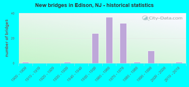
- New bridges - historical statistics
- 11900-1909
- 11930-1939
- 241950-1959
- 371960-1969
- 321970-1979
- 11980-1989
- 101990-1999
- 12010-2019
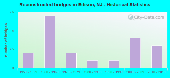
- Reconstructed bridges - Historical Statistics
- 21950-1959
- 71960-1969
- 21970-1979
- 11980-1989
- 11990-1999
- 42000-2009
- 32010-2019
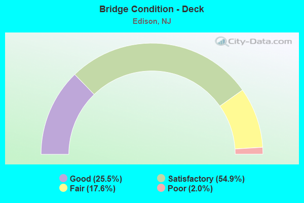
- Bridge Condition - Deck
- 25.5%Good
- 54.9%Satisfactory
- 17.6%Fair
- 2.0%Poor
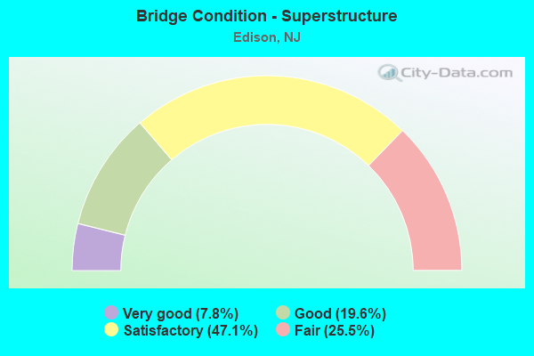
- Bridge Condition - Superstructure
- 7.8%Very good
- 19.6%Good
- 47.1%Satisfactory
- 25.5%Fair
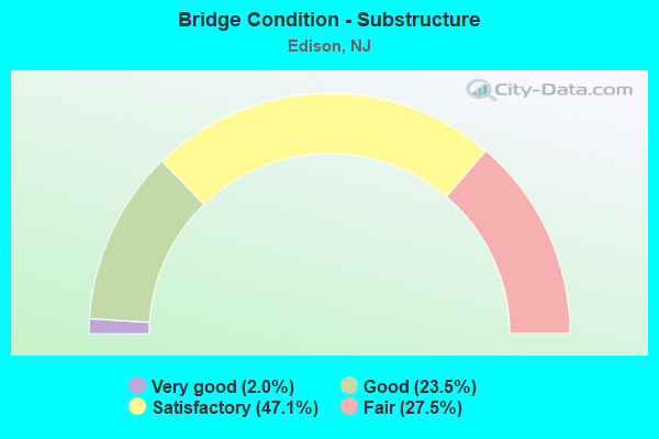
- Bridge Condition - Substructure
- 2.0%Very good
- 23.5%Good
- 47.1%Satisfactory
- 27.5%Fair
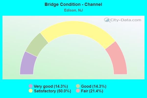
- Bridge Condition - Channel
- 14.3%Very good
- 14.3%Good
- 50.0%Satisfactory
- 21.4%Fair
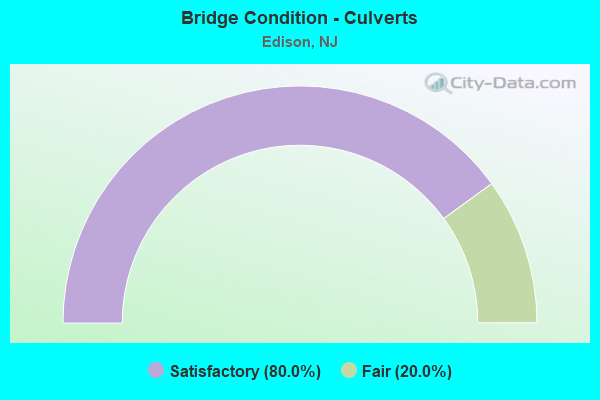
- Bridge Condition - Culverts
- 80.0%Satisfactory
- 20.0%Fair
Find on map >> Show street view
Structure Number: M08805A, Location: 0.60 MI SW OF I-95 (Lat: 40.524569, Lng: -74.343461), Route carried "under" structure: Interstate 95, Year Built: 1973, Structure Length: 0. m, Average Daily Traffic: 55,586 (year 2021), Truck Traffic: 28%, Features Intersected: NJ TPK(I-95) SNO RWY, Facility Carried by Structure: NJ TP RAMP SIT
Minimum Vertical Clearance: 4.93m (16.17ft), Kilometerpoint: 68.735, Lanes on structure: 1, Lanes under structure: 3, Toll: On toll road, Material/Design: Steel, Design/Construction: Stringer/Multi-beam, Length of Maximum Span: 38.4m (126.0ft)
Find on map >> Show street view
Structure Number: M08809A, Location: 0.42 MI SW OF INT 10 (Lat: 40.525997, Lng: -74.343244), Route carried "under" structure: Interstate 95, Year Built: 1970, Structure Length: 0. m, Average Daily Traffic: 45,000 (year 2021), Features Intersected: NJ TURNPIKE(I-95)
Minimum Vertical Clearance: 5.08m (16.67ft), Kilometerpoint: 68.767, Lanes on structure: 4, Lanes under structure: 14, Toll: On toll road, Material/Design: Steel, Design/Construction: Stringer/Multi-beam, Length of Maximum Span: 29.0m (95.1ft)
Find on map >> Show street view
Structure Number: M08813A, Location: 0.38 MI SW OF I-95 (Lat: 40.525322, Lng: -74.341908), Route carried "under" structure: Interstate 95, Year Built: 1970, Structure Length: 0. m, Average Daily Traffic: 55,500 (year 2021), Truck Traffic: 28%, Features Intersected: NJ TPK(I-95) SNO RWY, Facility Carried by Structure: NJ TP RAMP TNI
Minimum Vertical Clearance: 4.90m (16.08ft), Kilometerpoint: 68.832, Lanes on structure: 1, Lanes under structure: 3, Toll: On toll road, Material/Design: Steel, Design/Construction: Stringer/Multi-beam, Length of Maximum Span: 29.0m (95.1ft)
Find on map >> Show street view
Structure Number: M08828A, Location: 0.20 MI SW OF I-95 (Lat: 40.527447, Lng: -74.340117), Route carried "under" structure: Interstate 95, Year Built: 1973, Structure Length: 0. m, Average Daily Traffic: 45,121 (year 2021), Features Intersected: NJ TPK(I-95) NSO RWY, Facility Carried by Structure: NJ TP RAMP TSI
Minimum Vertical Clearance: 4.93m (16.17ft), Kilometerpoint: 69.073, Lanes on structure: 1, Lanes under structure: 3, Toll: On toll road, Material/Design: Steel, Design/Construction: Stringer/Multi-beam, Length of Maximum Span: 31.7m (104.0ft)
Find on map >> Show street view
Structure Number: M08833A, Location: 0.08 MI SW OF I-95 (Lat: 40.527706, Lng: -74.339394), Route carried "under" structure: Interstate 95, Year Built: 1970, Structure Length: 0. m, Average Daily Traffic: 45,000 (year 2021), Features Intersected: NJTPK(I-95) NSO ROADWAY
Minimum Vertical Clearance: 4.52m (14.83ft), Kilometerpoint: 69.154, Lanes on structure: 1, Lanes under structure: 3, Toll: On toll road, Material/Design: Steel, Design/Construction: Stringer/Multi-beam, Length of Maximum Span: 31.1m (102.0ft)
Find on map >> Show street view
Structure Number: M08889N, Location: 0.7 MI E OF US 1 (Lat: 40.532389, Lng: -74.330306), Route carried "under" structure: County highway 501, Year Built: 1969, Structure Length: 0. m, Average Daily Traffic: 14,080 (year 2021), Truck Traffic: 4%, Features Intersected: AMBOY AVE (EDISON TWP), Facility Carried by Structure: NJTPK SNI-SNO RWY
Minimum Vertical Clearance: 4.44m (14.57ft), Kilometerpoint: 8.739, Lanes on structure: 6, Lanes under structure: 2, Material/Design: Steel, Design/Construction: Stringer/Multi-beam, Length of Maximum Span: 18.3m (60.0ft)
Find on map >> Show street view
Structure Number: M08889S, Location: 1.3 MI S OF GSP (Lat: 40.532622, Lng: -74.331033), Route carried "under" structure: County highway 501, Year Built: 1950, Structure Length: 0. m, Average Daily Traffic: 17,313 (year 2021), Features Intersected: AMBOY AVENUE(EDISON TWP), Facility Carried by Structure: NJTPK NSO-NSI RWY
Minimum Vertical Clearance: 4.44m (14.57ft), Kilometerpoint: 8.739, Lanes on structure: 6, Lanes under structure: 2, Material/Design: Steel, Design/Construction: Stringer/Multi-beam, Length of Maximum Span: 18.3m (60.0ft)
Find on map >> Show street view
Structure Number: M08915, Location: 0.62 MI N OF I-95 (Lat: 40.535108, Lng: -74.327681), Route carried "under" structure: Interstate 95, Year Built: 1950, Structure Length: 0. m, Average Daily Traffic: 45,116 (year 2021), Truck Traffic: 14%, Features Intersected: NJ TURNPIKE RWYS, Facility Carried by Structure: GRANDVIEW AVENUE
Minimum Vertical Clearance: 10.39m (34.09ft), Kilometerpoint: 70.521, Lanes on structure: 2, Lanes under structure: 12, Toll: On toll road, Material/Design: Steel, Design/Construction: Stringer/Multi-beam, Length of Maximum Span: 23.5m (77.1ft)