Bridge Statistics for Edinburg, Texas (TX)
Condition, Traffic, Stress, Structural Evaluation, Project Costs
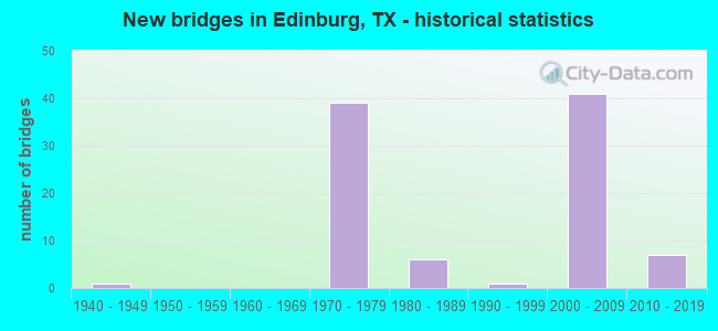
- New bridges - historical statistics
- 11940-1949
- 391970-1979
- 61980-1989
- 11990-1999
- 412000-2009
- 72010-2019
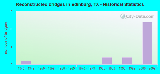
- Reconstructed bridges - Historical Statistics
- 11940-1949
- 01950-1959
- 01960-1969
- 01970-1979
- 21980-1989
- 21990-1999
- 122000-2009
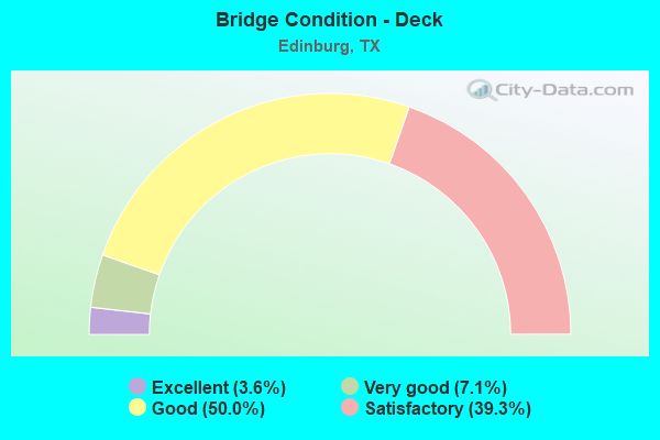
- Bridge Condition - Deck
- 3.6%Excellent
- 7.1%Very good
- 50.0%Good
- 39.3%Satisfactory
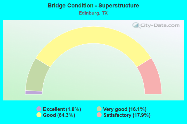
- Bridge Condition - Superstructure
- 1.8%Excellent
- 16.1%Very good
- 64.3%Good
- 17.9%Satisfactory
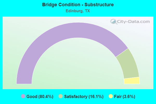
- Bridge Condition - Substructure
- 80.4%Good
- 16.1%Satisfactory
- 3.6%Fair
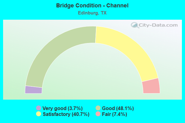
- Bridge Condition - Channel
- 3.7%Very good
- 48.1%Good
- 40.7%Satisfactory
- 7.4%Fair
Find on map >> Show street view
Structure Number: 211090052801003, Location: 0.25 MI E OF FM 2061 (Lat: 26.305372, Lng: -98.190161), Route carried "on" structure: State highway 107, Year Built: 1978, Year Reconstructed: 2008, Status: Open, Structure Length: 1.86m (6.10ft), Average Daily Traffic: 25,010 (year 2020), Truck Traffic: 3%, Average Future Daily Traffic: 44,950 (year 2030), Design Load: HS 20, Features Intersected: DRAIN
Minimum Vertical Clearance: 30+ m (98+ ft), Kilometerpoint: 24.757, Lanes on structure: 6, Owner: State Highway Agency, Approaching Roadway Width: 29.3m (96.1ft), Skew: 20 degrees, Material/Design: Prestressed concrete, Design/Construction: Box Beam or Girders - Multiple, Number Of Spans In Main Unit: 1, Length of Maximum Span: 18.3m (60.0ft), Curb or Sidewalk Widths: Left: 1.5m (4.9ft), Right: 1.5m (4.9ft), Curb-To-Curb Width: 29.3m (96.1ft), Out-to-Out Width: 38.4m (126.0ft)
Condition: Deck: Very good, Superstructure: Very good, Substructure: Good, Channel: Satisfactory, Operating Rating: 54.4 metric tons, Method Used To Determine Operating Rating: Assigned rating based on Load Factor Design (LFD) reported in metric tons, Inventory Rating: 32.7 metric tons, Method Used To Determine Inventory Rating: Assigned rating based on Load Factor Design (LFD) reported in metric tons, Structural Evaluation: Better than present minimum criteria, Deck Geometry: Superior to present desirable criteria, Waterway Adequacy: Equal to present minimum criteria, Approach Roadway Alignment: Equal to present desirable criteria, Designated Inspection Frequency: Every 24 months, Inspection Date: May 2021, Deck Structure Type: Concrete Precast Panels, Wearing Surface/Protective System: Wearing Surface: Bituminous
Find on map >> Show street view
Structure Number: 211090180301002, Location: 0.25 MI E OF FM 2061 (Lat: 26.341081, Lng: -98.184136), Route carried "on" structure: State highway 1925, Year Built: 1978, Year Reconstructed: 2003, Status: Open, Structure Length: 2.47m (8.10ft), Average Daily Traffic: 18,428 (year 2020), Truck Traffic: 4%, Average Future Daily Traffic: 29,840 (year 2031), Design Load: HS 20, Features Intersected: DRAIN
Minimum Vertical Clearance: 30+ m (98+ ft), Kilometerpoint: 15.044, Lanes on structure: 5, Owner: State Highway Agency, Approaching Roadway Width: 25.3m (83.0ft), Material/Design: Prestressed concrete, Design/Construction: Box Beam or Girders - Multiple, Number Of Spans In Main Unit: 2, Length of Maximum Span: 12.2m (40.0ft), Curb or Sidewalk Widths: Left: 1.6m (5.2ft), Right: 1.6m (5.2ft), Curb-To-Curb Width: 25.2m (82.7ft), Out-to-Out Width: 29.9m (98.1ft)
Condition: Deck: Very good, Superstructure: Good, Substructure: Good, Channel: Good, Operating Rating: 54.4 metric tons, Method Used To Determine Operating Rating: Assigned rating based on Load Factor Design (LFD) reported in metric tons, Inventory Rating: 32.7 metric tons, Method Used To Determine Inventory Rating: Assigned rating based on Load Factor Design (LFD) reported in metric tons, Structural Evaluation: Better than present minimum criteria, Deck Geometry: Superior to present desirable criteria, Waterway Adequacy: Superior to present desirable criteria, Approach Roadway Alignment: Equal to present desirable criteria, Designated Inspection Frequency: Every 24 months, Inspection Date: April 2021, Deck Structure Type: Concrete Cast-file-Place, Wearing Surface/Protective System: Wearing Surface: Bituminous
Find on map >> Show street view
Structure Number: 211090193901005, Location: 1.90 MI S OF SH 107 (Lat: 26.278550, Lng: -98.199572), Route carried "on" structure: State highway 2061, Year Built: 1978, Year Reconstructed: 1994, Status: Open, Structure Length: 2.01m (6.59ft), Average Daily Traffic: 24,582 (year 2019), Truck Traffic: 3%, Average Future Daily Traffic: 23,930 (year 2033), Design Load: HS 20, Features Intersected: MCALLEN LATERAL DRAIN
Minimum Vertical Clearance: 30+ m (98+ ft), Kilometerpoint: 7.094, Lanes on structure: 5, Owner: State Highway Agency, Approaching Roadway Width: 18.9m (62.0ft), Material/Design: Prestressed concrete, Design/Construction: Box Beam or Girders - Multiple, Number Of Spans In Main Unit: 1, Length of Maximum Span: 19.8m (65.0ft), Curb or Sidewalk Widths: Left: 1.1m (3.6ft), Right: 1.1m (3.6ft), Curb-To-Curb Width: 18.7m (61.4ft), Out-to-Out Width: 22.6m (74.1ft)
Condition: Deck: Very good, Superstructure: Good, Substructure: Good, Channel: Good, Operating Rating: 54.4 metric tons, Method Used To Determine Operating Rating: Assigned rating based on Load Factor Design (LFD) reported in metric tons, Inventory Rating: 32.7 metric tons, Method Used To Determine Inventory Rating: Assigned rating based on Load Factor Design (LFD) reported in metric tons, Structural Evaluation: Better than present minimum criteria, Deck Geometry: High priority of corrective action, Waterway Adequacy: Equal to present minimum criteria, Approach Roadway Alignment: Equal to present desirable criteria, Designated Inspection Frequency: Every 24 months, Inspection Date: May 2021, Deck Structure Type: Concrete Precast Panels, Wearing Surface/Protective System: Wearing Surface: Bituminous
Find on map >> Show street view
Structure Number: 211090193901008, Location: 0.7 MI N OF SH 107 (Lat: 26.316150, Lng: -98.192342), Route carried "on" structure: State highway 2061, Year Built: 1990, Year Reconstructed: 2007, Status: Open, Structure Length: 2.29m (7.51ft), Average Daily Traffic: 14,794 (year 2020), Truck Traffic: 3%, Average Future Daily Traffic: 33,680 (year 2030), Design Load: HS 20, Features Intersected: W MAIN I DRAIN
Minimum Vertical Clearance: 30+ m (98+ ft), Kilometerpoint: 2.849, Lanes on structure: 5, Owner: State Highway Agency, Approaching Roadway Width: 19.5m (64.0ft), Material/Design: Prestressed concrete, Design/Construction: Box Beam or Girders - Multiple, Number Of Spans In Main Unit: 2, Length of Maximum Span: 12.2m (40.0ft), Curb-To-Curb Width: 19.5m (64.0ft), Out-to-Out Width: 20.2m (66.3ft)
Condition: Deck: Very good, Superstructure: Good, Substructure: Good, Channel: Good, Operating Rating: 54.4 metric tons, Method Used To Determine Operating Rating: Assigned rating based on Load Factor Design (LFD) reported in metric tons, Inventory Rating: 32.7 metric tons, Method Used To Determine Inventory Rating: Assigned rating based on Load Factor Design (LFD) reported in metric tons, Structural Evaluation: Better than present minimum criteria, Deck Geometry: Meets minimum limits, Waterway Adequacy: Superior to present desirable criteria, Approach Roadway Alignment: Equal to present desirable criteria, Designated Inspection Frequency: Every 24 months, Inspection Date: May 2021, Deck Structure Type: Concrete Precast Panels, Wearing Surface/Protective System: Wearing Surface: Bituminous
Find on map >> Show street view
Structure Number: 211090346801001, Location: 0.25 MI N.OF WISCONSIN RD (Lat: 26.275431, Lng: -98.190964), Route carried "on" structure: State highway 3362, Year Built: 2000, Status: Open, Structure Length: 1.04m (3.41ft), Average Daily Traffic: 15,872 (year 2014), Truck Traffic: 2%, Average Future Daily Traffic: 18,480 (year 2033), Design Load: HS 20, Features Intersected: S.MAIN DRAINAGE DITCH
Minimum Vertical Clearance: 30+ m (98+ ft), Kilometerpoint: 3.283, Lanes on structure: 5, Owner: State Highway Agency, Approaching Roadway Width: 24.4m (80.1ft), Skew: 1 degrees, Material/Design: Concrete, Design/Construction: Culvert, Number Of Spans In Main Unit: 3, Length of Maximum Span: 3.0m (9.8ft), Curb or Sidewalk Widths: Left: 0.0m, Right: 2.4m (7.9ft)
Condition: Channel: Good, Culverts: Good, Operating Rating: 54.4 metric tons, Method Used To Determine Operating Rating: Assigned rating based on Load Factor Design (LFD) reported in metric tons, Inventory Rating: 32.7 metric tons, Method Used To Determine Inventory Rating: Assigned rating based on Load Factor Design (LFD) reported in metric tons, Structural Evaluation: Better than present minimum criteria, Waterway Adequacy: Equal to present minimum criteria, Approach Roadway Alignment: Equal to present desirable criteria, Designated Inspection Frequency: Every 48 months, Inspection Date: May 2021
Find on map >> Show street view
Structure Number: 211090AA0166001, Location: 3.05 MI N OF FM 1925 (Lat: 26.383197, Lng: -98.162311), Route carried "on" structure: County highway , Year Built: 1979, Status: Open, Structure Length: 2.83m (9.28ft), Average Daily Traffic: 1,560 (year 2019), Truck Traffic: 2%, Average Future Daily Traffic: 890 (year 2030), Features Intersected: N MAIN DRAINAGE DITCH, Facility Carried by Structure: SEMINARY RD
Minimum Vertical Clearance: 30+ m (98+ ft), Kilometerpoint: 4.908, Lanes on structure: 2, Owner: County Highway Agency, Approaching Roadway Width: 6.1m (20.0ft), Material/Design: Concrete, Design/Construction: Stringer/Multi-beam, Number Of Spans In Main Unit: 3, Length of Maximum Span: 9.1m (29.9ft), Curb-To-Curb Width: 7.9m (25.9ft), Out-to-Out Width: 8.7m (28.5ft)
Condition: Deck: Good, Superstructure: Good, Substructure: Satisfactory, Channel: Satisfactory, Operating Rating: 32.7 metric tons, Method Used To Determine Operating Rating: Field evaluation and documented engineering judgment, Inventory Rating: 24.5 metric tons, Method Used To Determine Inventory Rating: Field evaluation and documented engineering judgment, Structural Evaluation: Equal to present minimum criteria, Deck Geometry: Meets minimum limits, Waterway Adequacy: Better than present minimum criteria, Approach Roadway Alignment: Equal to present minimum criteria, Designated Inspection Frequency: Every 24 months, Inspection Date: June 2020, Deck Structure Type: Concrete Cast-file-Place
Find on map >> Show street view
Structure Number: 211090AA0266001, Location: 0.70 MI E OF US 281 (Lat: 26.265789, Lng: -98.147425), Route carried "on" structure: County highway , Year Built: 1989, Status: Open, Structure Length: 2.83m (9.28ft), Average Daily Traffic: 2,080 (year 2019), Truck Traffic: 2%, Average Future Daily Traffic: 1,860 (year 2030), Design Load: H 20, Features Intersected: PHARR-MCALLEN LATERAL, Facility Carried by Structure: WISCONSIN ROAD
Minimum Vertical Clearance: 30+ m (98+ ft), Kilometerpoint: 1.127, Lanes on structure: 2, Owner: County Highway Agency, Approaching Roadway Width: 6.1m (20.0ft), Material/Design: Concrete, Design/Construction: Stringer/Multi-beam, Number Of Spans In Main Unit: 3, Length of Maximum Span: 9.2m (30.2ft), Curb-To-Curb Width: 7.7m (25.3ft), Out-to-Out Width: 8.5m (27.9ft)
Condition: Deck: Satisfactory, Superstructure: Satisfactory, Substructure: Satisfactory, Channel: Satisfactory, Operating Rating: 68.0 metric tons, Method Used To Determine Operating Rating: Load Factor (LF), Inventory Rating: 40.8 metric tons, Method Used To Determine Inventory Rating: Load Factor (LF), Structural Evaluation: Equal to present minimum criteria, Deck Geometry: High priority of replacement, Waterway Adequacy: Better than present minimum criteria, Approach Roadway Alignment: Equal to present desirable criteria, Designated Inspection Frequency: Every 24 months, Inspection Date: May 2020, Deck Structure Type: Concrete Cast-file-Place
Find on map >> Show street view
Structure Number: 211090AA3534002, Location: 0.3 MI OF SCHUNIOR RD (Lat: 26.320200, Lng: -98.216200), Route carried "on" structure: County highway , Year Built: 2019, Status: Open, Structure Length: 3.66m (12.01ft), Average Daily Traffic: 1,000 (year 2010), Truck Traffic: 3%, Average Future Daily Traffic: 1,600 (year 2030), Design Load: HL 93, Features Intersected: HIDALGO W MAIN DRAIN, Facility Carried by Structure: 10TH ST
Minimum Vertical Clearance: 30+ m (98+ ft), Kilometerpoint: 0.451, Lanes on structure: 5, Owner: County Highway Agency, Approaching Roadway Width: 25.6m (84.0ft), Material/Design: Prestressed concrete, Design/Construction: Stringer/Multi-beam, Number Of Spans In Main Unit: 3, Length of Maximum Span: 15.2m (49.9ft), Curb or Sidewalk Widths: Left: 1.8m (5.9ft), Right: 1.8m (5.9ft), Curb-To-Curb Width: 30.5m (100.1ft), Out-to-Out Width: 36.6m (120.1ft)
Condition: Deck: Excellent, Superstructure: Good, Substructure: Good, Channel: Good, Operating Rating: 54.4 metric tons, Method Used To Determine Operating Rating: Assigned ratings based on Load and Resistance Factor Design (LRFD) reported in metric tons, Inventory Rating: 32.7 metric tons, Method Used To Determine Inventory Rating: Assigned ratings based on Load and Resistance Factor Design (LRFD) reported in metric tons, Structural Evaluation: Better than present minimum criteria, Deck Geometry: Superior to present desirable criteria, Waterway Adequacy: Superior to present desirable criteria, Approach Roadway Alignment: Equal to present desirable criteria, Designated Inspection Frequency: Every 24 months, Inspection Date: May 2020, Deck Structure Type: Concrete Cast-file-Place
Find on map >> Show street view
Structure Number: 211090E00183001, Location: 0.20 MI N OF SH 107 (Lat: 26.314025, Lng: -98.225489), Route carried "on" structure: City street , Year Built: 1989, Status: Open, Structure Length: 2.80m (9.19ft), Average Daily Traffic: 4,661 (year 2019), Truck Traffic: 4%, Average Future Daily Traffic: 2,420 (year 2029), Features Intersected: HIDALGO W MAIN DRAIN, Facility Carried by Structure: DEPOT RD
Minimum Vertical Clearance: 30+ m (98+ ft), Kilometerpoint: 0.338, Lanes on structure: 2, Owner: City or Municipal Highway Agency, Approaching Roadway Width: 7.3m (24.0ft), Material/Design: Concrete, Design/Construction: Stringer/Multi-beam, Number Of Spans In Main Unit: 3, Length of Maximum Span: 9.1m (29.9ft), Curb-To-Curb Width: 8.4m (27.6ft), Out-to-Out Width: 9.2m (30.2ft)
Condition: Deck: Satisfactory, Superstructure: Satisfactory, Substructure: Good, Channel: Satisfactory, Operating Rating: 32.7 metric tons, Method Used To Determine Operating Rating: Field evaluation and documented engineering judgment, Inventory Rating: 24.5 metric tons, Method Used To Determine Inventory Rating: Field evaluation and documented engineering judgment, Structural Evaluation: Equal to present minimum criteria, Deck Geometry: High priority of corrective action, Waterway Adequacy: Better than present minimum criteria, Approach Roadway Alignment: Equal to present desirable criteria, Designated Inspection Frequency: Every 24 months, Inspection Date: May 2020, Deck Structure Type: Concrete Cast-file-Place
Find on map >> Show street view
Structure Number: 211090E00320001, Location: 0.25 MI E OF FM 2061 (Lat: 26.290975, Lng: -98.192722), Route carried "on" structure: City street , Year Built: 1975, Year Reconstructed: 1986, Status: Open, Structure Length: 1.59m (5.22ft), Average Daily Traffic: 16,962 (year 2019), Truck Traffic: 4%, Average Future Daily Traffic: 15,000 (year 2029), Features Intersected: N MAIN DRAINAGE DITCH, Facility Carried by Structure: FREDDY GONZALEZ DR
Minimum Vertical Clearance: 30+ m (98+ ft), Kilometerpoint: 1.094, Lanes on structure: 5, Owner: City or Municipal Highway Agency, Approaching Roadway Width: 19.5m (64.0ft), Material/Design: Prestressed concrete, Design/Construction: Box Beam or Girders - Multiple, Number Of Spans In Main Unit: 1, Length of Maximum Span: 15.2m (49.9ft), Curb or Sidewalk Widths: Left: 1.2m (3.9ft), Right: 0.0m, Curb-To-Curb Width: 20.1m (65.9ft), Out-to-Out Width: 22.1m (72.5ft)
Condition: Deck: Good, Superstructure: Good, Substructure: Satisfactory, Channel: Satisfactory, Operating Rating: 32.7 metric tons, Method Used To Determine Operating Rating: Field evaluation and documented engineering judgment, Inventory Rating: 24.5 metric tons, Method Used To Determine Inventory Rating: Field evaluation and documented engineering judgment, Structural Evaluation: Equal to present minimum criteria, Deck Geometry: Somewhat better than minimum adequacy, Waterway Adequacy: Better than present minimum criteria, Approach Roadway Alignment: Equal to present desirable criteria, Designated Inspection Frequency: Every 24 months, Inspection Date: May 2020, Deck Structure Type: Concrete Precast Panels, Wearing Surface/Protective System: Wearing Surface: Bituminous
Find on map >> Show street view
Structure Number: 211090E00344001, Location: 0.75 MI N OF SH 107 (Lat: 26.320175, Lng: -98.216167), Route carried "on" structure: City street , Year Built: 1989, Status: Open, Structure Length: 0.67m (2.20ft), Average Daily Traffic: 1,110 (year 2010), Truck Traffic: 4%, Average Future Daily Traffic: 1,340 (year 2029), Features Intersected: HIDALGO W MAIN DRAIN, Facility Carried by Structure: HOEHN RD
Minimum Vertical Clearance: 30+ m (98+ ft), Kilometerpoint: 1.207, Lanes on structure: 2, Owner: City or Municipal Highway Agency, Approaching Roadway Width: 6.1m (20.0ft), Material/Design: Concrete, Design/Construction: Culvert, Number Of Spans In Main Unit: 2, Length of Maximum Span: 3.0m (9.8ft)
Condition: Channel: Good, Culverts: Good, Operating Rating: 32.7 metric tons, Method Used To Determine Operating Rating: Field evaluation and documented engineering judgment, Inventory Rating: 24.5 metric tons, Method Used To Determine Inventory Rating: Field evaluation and documented engineering judgment, Structural Evaluation: Equal to present minimum criteria, Waterway Adequacy: Better than present minimum criteria, Approach Roadway Alignment: Equal to present desirable criteria, Designated Inspection Frequency: Every 24 months, Inspection Date: May 2020
Find on map >> Show street view
Structure Number: 211090E00365001, Location: 0.25 MI N OF WISCONSIN (Lat: 26.270436, Lng: -98.154325), Route carried "on" structure: City street , Year Built: 2010, Status: Open, Structure Length: 0.76m (2.49ft), Average Daily Traffic: 5,241 (year 2020), Truck Traffic: 4%, Average Future Daily Traffic: 2,160 (year 2029), Design Load: HS 20, Features Intersected: HIDALGO S MAIN DRAIN, Facility Carried by Structure: N I RD
Minimum Vertical Clearance: 30+ m (98+ ft), Kilometerpoint: 8.771, Lanes on structure: 3, Owner: City or Municipal Highway Agency, Approaching Roadway Width: 19.5m (64.0ft), Skew: 20 degrees, Material/Design: Concrete, Design/Construction: Culvert, Number Of Spans In Main Unit: 2, Length of Maximum Span: 3.0m (9.8ft)
Condition: Channel: Satisfactory, Culverts: Good, Operating Rating: 54.4 metric tons, Method Used To Determine Operating Rating: Assigned rating based on Load Factor Design (LFD) reported in metric tons, Inventory Rating: 32.7 metric tons, Method Used To Determine Inventory Rating: Assigned rating based on Load Factor Design (LFD) reported in metric tons, Structural Evaluation: Better than present minimum criteria, Waterway Adequacy: Superior to present desirable criteria, Approach Roadway Alignment: Equal to present desirable criteria, Designated Inspection Frequency: Every 24 months, Inspection Date: May 2020
Find on map >> Show street view
Structure Number: 211090E00525001, Location: 0.60 MI N OF SH 107 (Lat: 26.315450, Lng: -98.200667), Route carried "on" structure: City street , Year Built: 1989, Status: Open, Structure Length: 2.80m (9.19ft), Average Daily Traffic: 5,275 (year 2019), Truck Traffic: 4%, Average Future Daily Traffic: 2,140 (year 2029), Features Intersected: HIDALGO W MAIN DRAIN, Facility Carried by Structure: MON MACK RD
Minimum Vertical Clearance: 30+ m (98+ ft), Kilometerpoint: 2.575, Lanes on structure: 2, Owner: City or Municipal Highway Agency, Approaching Roadway Width: 7.3m (24.0ft), Material/Design: Concrete, Design/Construction: Stringer/Multi-beam, Number Of Spans In Main Unit: 3, Length of Maximum Span: 9.1m (29.9ft), Curb-To-Curb Width: 8.4m (27.6ft), Out-to-Out Width: 9.2m (30.2ft)
Condition: Deck: Satisfactory, Superstructure: Satisfactory, Substructure: Satisfactory, Channel: Satisfactory, Operating Rating: 32.7 metric tons, Method Used To Determine Operating Rating: Field evaluation and documented engineering judgment, Inventory Rating: 24.5 metric tons, Method Used To Determine Inventory Rating: Field evaluation and documented engineering judgment, Structural Evaluation: Equal to present minimum criteria, Deck Geometry: High priority of replacement, Waterway Adequacy: Better than present minimum criteria, Approach Roadway Alignment: Equal to present desirable criteria, Designated Inspection Frequency: Every 24 months, Inspection Date: May 2020, Deck Structure Type: Concrete Cast-file-Place
Find on map >> Show street view
Structure Number: 211090E00657001, Location: 0.25 MI E OF FM 2061 (Lat: 26.326856, Lng: -98.186406), Route carried "on" structure: City street , Year Built: 1975, Status: Open, Structure Length: 1.74m (5.71ft), Average Daily Traffic: 5,369 (year 2019), Truck Traffic: 2%, Average Future Daily Traffic: 3,740 (year 2029), Features Intersected: N MAIN DRAINAGE DITCH, Facility Carried by Structure: MILE 17-1/2 N RD
Minimum Vertical Clearance: 30+ m (98+ ft), Kilometerpoint: 6.035, Lanes on structure: 2, Owner: City or Municipal Highway Agency, Approaching Roadway Width: 10.4m (34.1ft), Material/Design: Prestressed concrete, Design/Construction: Box Beam or Girders - Multiple, Number Of Spans In Main Unit: 1, Length of Maximum Span: 16.8m (55.1ft), Curb-To-Curb Width: 7.9m (25.9ft), Out-to-Out Width: 8.6m (28.2ft)
Condition: Deck: Good, Superstructure: Good, Substructure: Good, Channel: Satisfactory, Operating Rating: 32.7 metric tons, Method Used To Determine Operating Rating: Field evaluation and documented engineering judgment, Inventory Rating: 24.5 metric tons, Method Used To Determine Inventory Rating: Field evaluation and documented engineering judgment, Structural Evaluation: Equal to present minimum criteria, Deck Geometry: High priority of replacement, Waterway Adequacy: Better than present minimum criteria, Approach Roadway Alignment: Equal to present desirable criteria, Designated Inspection Frequency: Every 24 months, Inspection Date: May 2020, Deck Structure Type: Concrete Precast Panels, Wearing Surface/Protective System: Wearing Surface: Bituminous
Find on map >> Show street view
Structure Number: 211090E00668001, Location: 0.25 MI E OF FM 2061 (Lat: 26.333953, Lng: -98.185086), Route carried "on" structure: City street , Year Built: 1975, Status: Open, Structure Length: 1.74m (5.71ft), Average Daily Traffic: 4,186 (year 2019), Truck Traffic: 2%, Average Future Daily Traffic: 3,420 (year 2029), Features Intersected: N MAIN DRAINAGE DITCH, Facility Carried by Structure: ROGERS RD
Minimum Vertical Clearance: 30+ m (98+ ft), Kilometerpoint: 2.575, Lanes on structure: 2, Owner: City or Municipal Highway Agency, Approaching Roadway Width: 6.1m (20.0ft), Material/Design: Prestressed concrete, Design/Construction: Box Beam or Girders - Multiple, Number Of Spans In Main Unit: 1, Length of Maximum Span: 16.8m (55.1ft), Curb-To-Curb Width: 7.9m (25.9ft), Out-to-Out Width: 8.6m (28.2ft)
Condition: Deck: Satisfactory, Superstructure: Satisfactory, Substructure: Good, Channel: Satisfactory, Operating Rating: 32.7 metric tons, Method Used To Determine Operating Rating: Field evaluation and documented engineering judgment, Inventory Rating: 24.5 metric tons, Method Used To Determine Inventory Rating: Field evaluation and documented engineering judgment, Structural Evaluation: Equal to present minimum criteria, Deck Geometry: High priority of corrective action, Waterway Adequacy: Better than present minimum criteria, Approach Roadway Alignment: Equal to present desirable criteria, Designated Inspection Frequency: Every 24 months, Inspection Date: May 2020, Deck Structure Type: Concrete Precast Panels, Wearing Surface/Protective System: Wearing Surface: Bituminous
Find on map >> Show street view
Structure Number: 211090E00695001, Location: 0.25 MI E OF FM 2061 (Lat: 26.319617, Lng: -98.187739), Route carried "on" structure: City street , Year Built: 1975, Status: Posted for load, Structure Length: 1.74m (5.71ft), Average Daily Traffic: 7,028 (year 2019), Truck Traffic: 2%, Average Future Daily Traffic: 6,510 (year 2029), Features Intersected: N MAIN DRAINAGE DITCH, Facility Carried by Structure: SCHUNIOR RD
Minimum Vertical Clearance: 30+ m (98+ ft), Kilometerpoint: 4.426, Lanes on structure: 2, Owner: City or Municipal Highway Agency, Approaching Roadway Width: 7.9m (25.9ft), Material/Design: Prestressed concrete, Design/Construction: Box Beam or Girders - Multiple, Number Of Spans In Main Unit: 1, Length of Maximum Span: 16.8m (55.1ft), Curb-To-Curb Width: 8.1m (26.6ft), Out-to-Out Width: 8.6m (28.2ft)
Condition: Deck: Satisfactory, Superstructure: Satisfactory, Substructure: Fair, Channel: Fair, Operating Rating: 32.7 metric tons, Method Used To Determine Operating Rating: Field evaluation and documented engineering judgment, Inventory Rating: 24.5 metric tons, Method Used To Determine Inventory Rating: Field evaluation and documented engineering judgment, Structural Evaluation: Somewhat better than minimum adequacy, Deck Geometry: High priority of replacement, Waterway Adequacy: Better than present minimum criteria, Approach Roadway Alignment: Equal to present desirable criteria, Bridge Posting: Required (Relationship of Operating Rating to Maximum Legal Load: 30.0 - 39.9% below), Length Of Structure Improvement: 1.74m (5.71ft), Designated Inspection Frequency: Every 24 months, Inspection Date: May 2020, Bridge Improvement Cost: $3,000, Roadway Improvement Cost: $1,000, Total Project Cost: $4,000, Deck Structure Type: Concrete Precast Panels, Wearing Surface/Protective System: Wearing Surface: Bituminous
Find on map >> Show street view
Structure Number: 211090E00695002, Location: 0.35 MI W OF DEPOT RD (Lat: 26.316772, Lng: -98.219119), Route carried "on" structure: City street , Year Built: 1989, Status: Open, Structure Length: 2.80m (9.19ft), Average Daily Traffic: 1,543 (year 2019), Truck Traffic: 4%, Average Future Daily Traffic: 1,510 (year 2029), Features Intersected: HIDALGO W MAIN DRAIN, Facility Carried by Structure: SCHUNIOR RD
Minimum Vertical Clearance: 30+ m (98+ ft), Kilometerpoint: 1.448, Lanes on structure: 2, Owner: City or Municipal Highway Agency, Approaching Roadway Width: 6.1m (20.0ft), Material/Design: Concrete, Design/Construction: Stringer/Multi-beam, Number Of Spans In Main Unit: 3, Length of Maximum Span: 9.1m (29.9ft), Curb-To-Curb Width: 8.4m (27.6ft), Out-to-Out Width: 9.2m (30.2ft)
Condition: Deck: Good, Superstructure: Good, Substructure: Good, Channel: Good, Operating Rating: 32.7 metric tons, Method Used To Determine Operating Rating: Field evaluation and documented engineering judgment, Inventory Rating: 24.5 metric tons, Method Used To Determine Inventory Rating: Field evaluation and documented engineering judgment, Structural Evaluation: Equal to present minimum criteria, Deck Geometry: Meets minimum limits, Waterway Adequacy: Better than present minimum criteria, Approach Roadway Alignment: Equal to present desirable criteria, Designated Inspection Frequency: Every 24 months, Inspection Date: May 2020, Deck Structure Type: Concrete Cast-file-Place
Find on map >> Show street view
Structure Number: 211090E00785001, Location: 0.25 MI E OF FM 2061 (Lat: 26.298069, Lng: -98.191469), Route carried "on" structure: City street , Year Built: 1975, Status: Open, Structure Length: 1.59m (5.22ft), Average Daily Traffic: 6,087 (year 2019), Truck Traffic: 2%, Average Future Daily Traffic: 8,040 (year 2036), Features Intersected: N MAIN DRAINAGE DITCH, Facility Carried by Structure: SPRAGUE RD
Minimum Vertical Clearance: 30+ m (98+ ft), Kilometerpoint: 3.621, Lanes on structure: 2, Owner: City or Municipal Highway Agency, Approaching Roadway Width: 6.1m (20.0ft), Material/Design: Prestressed concrete, Design/Construction: Box Beam or Girders - Multiple, Number Of Spans In Main Unit: 1, Length of Maximum Span: 15.2m (49.9ft), Curb-To-Curb Width: 7.9m (25.9ft), Out-to-Out Width: 8.6m (28.2ft)
Condition: Deck: Satisfactory, Superstructure: Satisfactory, Substructure: Satisfactory, Channel: Fair, Operating Rating: 32.7 metric tons, Method Used To Determine Operating Rating: Field evaluation and documented engineering judgment, Inventory Rating: 24.5 metric tons, Method Used To Determine Inventory Rating: Field evaluation and documented engineering judgment, Structural Evaluation: Equal to present minimum criteria, Deck Geometry: High priority of replacement, Waterway Adequacy: Better than present minimum criteria, Approach Roadway Alignment: Equal to present desirable criteria, Length Of Structure Improvement: 1.59m (5.22ft), Designated Inspection Frequency: Every 24 months, Inspection Date: May 2020, Bridge Improvement Cost: $3,000, Roadway Improvement Cost: $1,000, Total Project Cost: $4,000, Deck Structure Type: Concrete Precast Panels, Wearing Surface/Protective System: Wearing Surface: Bituminous
Find on map >> Show street view
Structure Number: 211090E00805001, Location: 0.25 MI N OF WISCONSIN RD (Lat: 26.274306, Lng: -98.182872), Route carried "on" structure: City street , Year Built: 1986, Year Reconstructed: 1996, Status: Open, Structure Length: 2.83m (9.28ft), Average Daily Traffic: 12,010 (year 2016), Truck Traffic: 2%, Average Future Daily Traffic: 12,460 (year 2036), Design Load: H 15, Features Intersected: S MAIN DRAINAGE DITCH, Facility Carried by Structure: SOUTH SUGAR ROAD
Minimum Vertical Clearance: 30+ m (98+ ft), Kilometerpoint: 6.679, Lanes on structure: 4, Owner: City or Municipal Highway Agency, Approaching Roadway Width: 15.5m (50.9ft), Material/Design: Concrete, Design/Construction: Stringer/Multi-beam, Number Of Spans In Main Unit: 3, Length of Maximum Span: 9.1m (29.9ft), Curb or Sidewalk Widths: Left: 1.5m (4.9ft), Right: 1.7m (5.6ft), Curb-To-Curb Width: 15.6m (51.2ft), Out-to-Out Width: 20.2m (66.3ft)
Condition: Deck: Satisfactory, Superstructure: Satisfactory, Substructure: Fair, Channel: Satisfactory, Operating Rating: 68.0 metric tons, Method Used To Determine Operating Rating: Load Factor (LF), Inventory Rating: 40.8 metric tons, Method Used To Determine Inventory Rating: Load Factor (LF), Structural Evaluation: Somewhat better than minimum adequacy, Deck Geometry: Meets minimum limits, Waterway Adequacy: Better than present minimum criteria, Approach Roadway Alignment: Equal to present desirable criteria, Designated Inspection Frequency: Every 24 months, Inspection Date: May 2020, Deck Structure Type: Concrete Cast-file-Place
Find on map >> Show street view
Structure Number: 211090LH3636001, Location: 0.25 Ml E OF FM 2061 (Lat: 26.319592, Lng: -98.187794), Route carried "on" structure: County highway , Year Built: 2019, Status: Open, Structure Length: 1.98m (6.50ft), Average Daily Traffic: 11,780 (year 2010), Truck Traffic: 2%, Average Future Daily Traffic: 12,200 (year 2029), Design Load: HL 93, Features Intersected: N. Main Drainage Ditch, Facility Carried by Structure: Chapin Road
Minimum Vertical Clearance: 30+ m (98+ ft), Kilometerpoint: 0.805, Lanes on structure: 2, Owner: City or Municipal Highway Agency, Approaching Roadway Width: 13.4m (44.0ft), Material/Design: Prestressed concrete, Design/Construction: Box Beam or Girders - Multiple, Number Of Spans In Main Unit: 1, Length of Maximum Span: 19.8m (65.0ft), Curb or Sidewalk Widths: Left: 1.8m (5.9ft), Right: 1.8m (5.9ft), Curb-To-Curb Width: 13.4m (44.0ft), Out-to-Out Width: 17.7m (58.1ft)
Condition: Deck: Excellent, Superstructure: Excellent, Substructure: Good, Channel: Good, Operating Rating: 54.4 metric tons, Method Used To Determine Operating Rating: Assigned ratings based on Load and Resistance Factor Design (LRFD) reported in metric tons, Inventory Rating: 32.7 metric tons, Method Used To Determine Inventory Rating: Assigned ratings based on Load and Resistance Factor Design (LRFD) reported in metric tons, Structural Evaluation: Better than present minimum criteria, Deck Geometry: Equal to present minimum criteria, Waterway Adequacy: Superior to present desirable criteria, Approach Roadway Alignment: Equal to present desirable criteria, Designated Inspection Frequency: Every 24 months, Inspection Date: May 2020, Deck Structure Type: Concrete Precast Panels
Find on map >> Show street view
Structure Number: 211090025507001, Location: 0.50 MI N OF SH 107 (Lat: 26.306461, Lng: -98.146147), Route carried "under" structure: State highway 2128, Year Built: 2007, Structure Length: 0. m, Average Daily Traffic: 13,030 (year 2013), Truck Traffic: 3%, Features Intersected: FM 2128, Facility Carried by Structure: US 281 SB OFF RAMP
Minimum Vertical Clearance: 6.20m (20.34ft), Kilometerpoint: 1.530, Lanes on structure: 1, Lanes under structure: 8, Material/Design: Prestressed concrete, Design/Construction: Stringer/Multi-beam, Length of Maximum Span: 39.6m (129.9ft)
Find on map >> Show street view
Structure Number: 211090025507043, Location: 0.75 MI N OF SH 107 (Lat: 26.310436, Lng: -98.146403), Year Built: 1978, Structure Length: 0. m, Features Intersected: UPRR (ABANDONED)
Minimum Vertical Clearance: 6.99m (22.93ft), Lanes on structure: 3, Lanes under structure: 2, Material/Design: Prestressed concrete, Design/Construction: Stringer/Multi-beam, Length of Maximum Span: 21.3m (69.9ft)
Find on map >> Show street view
Structure Number: 211090025507044, Location: 0.75 MI N OF SH 107 (Lat: 26.309861, Lng: -98.146011), Year Built: 1978, Structure Length: 0. m, Features Intersected: UPRR (ABANDONED)
Minimum Vertical Clearance: 6.91m (22.67ft), Lanes on structure: 4, Lanes under structure: 2, Material/Design: Prestressed concrete, Design/Construction: Stringer/Multi-beam, Length of Maximum Span: 21.3m (69.9ft)
Find on map >> Show street view
Structure Number: 211090025507045, Location: 0.6 MI N OF FM 1925 (Lat: 26.344181, Lng: -98.148111), Route carried "under" structure: Business State highway 281, Year Built: 1978, Structure Length: 0. m, Average Daily Traffic: 3,100 (year 2011), Truck Traffic: 3%, Features Intersected: BU 281 NB
Minimum Vertical Clearance: 5.82m (19.09ft), Kilometerpoint: 1.775, Lanes on structure: 2, Lanes under structure: 3, Material/Design: Prestressed concrete, Design/Construction: Stringer/Multi-beam, Length of Maximum Span: 29.9m (98.1ft)
Find on map >> Show street view
Structure Number: 211090025507046, Location: 0.6 MI N OF FM 1925 (Lat: 26.343703, Lng: -98.147544), Route carried "under" structure: Business State highway 281, Year Built: 1978, Structure Length: 0. m, Average Daily Traffic: 3,100 (year 2011), Truck Traffic: 3%, Features Intersected: BU 281 NB
Minimum Vertical Clearance: 5.31m (17.42ft), Kilometerpoint: 1.823, Lanes on structure: 2, Lanes under structure: 3, Material/Design: Prestressed concrete, Design/Construction: Stringer/Multi-beam, Length of Maximum Span: 31.1m (102.0ft)
Find on map >> Show street view
Structure Number: 211090025507047, Location: 2.50 MI N OF SH 107 (Lat: 26.335744, Lng: -98.145403), Route carried "under" structure: State highway 1925, Year Built: 1978, Structure Length: 0. m, Average Daily Traffic: 15,000 (year 2013), Truck Traffic: 3%, Features Intersected: FM 1925 MONTE CRISTO RD, Facility Carried by Structure: US 281 SB
Minimum Vertical Clearance: 5.01m (16.44ft), Kilometerpoint: 1.099, Lanes on structure: 2, Lanes under structure: 8, Material/Design: Prestressed concrete, Design/Construction: Stringer/Multi-beam, Length of Maximum Span: 27.4m (89.9ft)
Find on map >> Show street view
Structure Number: 211090025507048, Location: 2.50 MI N OF SH 107 (Lat: 26.335217, Lng: -98.145000), Route carried "under" structure: State highway 1925, Year Built: 1978, Structure Length: 0. m, Average Daily Traffic: 15,000 (year 2013), Truck Traffic: 3%, Features Intersected: FM 1925 MONTE CRISTO RD, Facility Carried by Structure: US 281 NB
Minimum Vertical Clearance: 5.33m (17.49ft), Kilometerpoint: 1.099, Lanes on structure: 2, Lanes under structure: 8, Material/Design: Prestressed concrete, Design/Construction: Stringer/Multi-beam, Length of Maximum Span: 27.4m (89.9ft)
Find on map >> Show street view
Structure Number: 211090025507049, Location: 1.00 MI N OF SH 107 (Lat: 26.313644, Lng: -98.146658), Route carried "under" structure: City street , Year Built: 1978, Structure Length: 0. m, Average Daily Traffic: 1,000 (year 2013), Truck Traffic: 2%, Features Intersected: CHAPIN ST, Facility Carried by Structure: US 281 SB
Minimum Vertical Clearance: 5.08m (16.67ft), Kilometerpoint: 0.000, Lanes on structure: 3, Lanes under structure: 2, Material/Design: Prestressed concrete, Design/Construction: Stringer/Multi-beam, Length of Maximum Span: 27.4m (89.9ft)
Find on map >> Show street view
Structure Number: 21109002550705, Location: 1.00 MI N OF SH 107 (Lat: 26.313650, Lng: -98.146544), Route carried "under" structure: City street , Year Built: 1978, Structure Length: 0. m, Average Daily Traffic: 1,000 (year 2012), Truck Traffic: 2%, Features Intersected: CHAPIN ST, Facility Carried by Structure: US 281 NB
Minimum Vertical Clearance: 5.18m (16.99ft), Kilometerpoint: 0.000, Lanes on structure: 4, Lanes under structure: 2, Material/Design: Prestressed concrete, Design/Construction: Stringer/Multi-beam, Length of Maximum Span: 27.4m (89.9ft)
Find on map >> Show street view
Structure Number: 211090025507053, Location: 6.9 MI N OF US 83 (Lat: 26.299581, Lng: -98.147092), Route carried "under" structure: State highway 107, Year Built: 1978, Structure Length: 0. m, Average Daily Traffic: 11,560 (year 2013), Truck Traffic: 3%, Features Intersected: SH 107, Facility Carried by Structure: US 281 SB
Minimum Vertical Clearance: 5.05m (16.57ft), Kilometerpoint: 33.502, Lanes on structure: 4, Lanes under structure: 8, Material/Design: Prestressed concrete, Design/Construction: Stringer/Multi-beam, Length of Maximum Span: 30.5m (100.1ft)
Find on map >> Show street view
Structure Number: 211090025507054, Location: 6.9 MI N OF US 83 (Lat: 26.299075, Lng: -98.146786), Route carried "under" structure: State highway 107, Year Built: 1978, Structure Length: 0. m, Average Daily Traffic: 11,560 (year 2013), Truck Traffic: 3%, Features Intersected: SH 107, Facility Carried by Structure: US 281 NB
Minimum Vertical Clearance: 5.03m (16.50ft), Kilometerpoint: 33.486, Lanes on structure: 4, Lanes under structure: 8, Material/Design: Prestressed concrete, Design/Construction: Stringer/Multi-beam, Length of Maximum Span: 30.5m (100.1ft)
Find on map >> Show street view
Structure Number: 211090025507055, Location: 1.50 MI N OF SH 107 (Lat: 26.321228, Lng: -98.148019), Route carried "under" structure: US 281, Year Built: 1978, Structure Length: 0. m, Average Daily Traffic: 37,550 (year 2011), Truck Traffic: 24%, Features Intersected: US 281, Facility Carried by Structure: RUSSELL RD
Minimum Vertical Clearance: 5.54m (18.18ft), Kilometerpoint: 52.099, Lanes on structure: 2, Lanes under structure: 11, Material/Design: Prestressed concrete, Design/Construction: Stringer/Multi-beam, Length of Maximum Span: 30.5m (100.1ft)
Find on map >> Show street view
Structure Number: 211090025507093, Location: 0.50 MI N OF SH 107 (Lat: 26.306444, Lng: -98.146033), Route carried "under" structure: State highway 2128, Year Built: 2008, Structure Length: 0. m, Average Daily Traffic: 13,030 (year 2013), Truck Traffic: 3%, Features Intersected: FM 2128 (SCHUNIOR ST), Facility Carried by Structure: US 281 SB
Minimum Vertical Clearance: 5.49m (18.01ft), Kilometerpoint: 1.550, Lanes on structure: 3, Lanes under structure: 7, Material/Design: Prestressed concrete, Design/Construction: Stringer/Multi-beam, Length of Maximum Span: 35.4m (116.1ft)
Find on map >> Show street view
Structure Number: 211090025507094, Location: 0.50 MI N. OF SH 107 (Lat: 26.305719, Lng: -98.145742), Route carried "under" structure: State highway 2128, Year Built: 2008, Structure Length: 0. m, Average Daily Traffic: 15,360 (year 2013), Truck Traffic: 2%, Features Intersected: FM 2128 (SCHUNIOR ST), Facility Carried by Structure: US 281 NB
Minimum Vertical Clearance: 6.04m (19.82ft), Kilometerpoint: 1.568, Lanes on structure: 3, Lanes under structure: 7, Material/Design: Prestressed concrete, Design/Construction: Stringer/Multi-beam, Length of Maximum Span: 35.4m (116.1ft)
Find on map >> Show street view
Structure Number: 211090025507095, Location: 2.1 MI S OF FM 162 (Lat: 26.385031, Lng: -98.142236), Route carried "under" structure: State highway 2812, Year Built: 2002, Structure Length: 0. m, Average Daily Traffic: 9,610 (year 2013), Truck Traffic: 7%, Features Intersected: FM 2812, Facility Carried by Structure: US 281 NB
Minimum Vertical Clearance: 5.44m (17.85ft), Kilometerpoint: 0.113, Lanes on structure: 2, Lanes under structure: 6, Material/Design: Prestressed concrete, Design/Construction: Stringer/Multi-beam, Length of Maximum Span: 34.1m (111.9ft)
Find on map >> Show street view
Structure Number: 211090025507096, Location: 2.1 MI S OF FM 162 (Lat: 26.385589, Lng: -98.142475), Route carried "under" structure: State highway 2812, Year Built: 2002, Structure Length: 0. m, Average Daily Traffic: 9,610 (year 2013), Truck Traffic: 7%, Features Intersected: FM 2812, Facility Carried by Structure: US 281 SB
Minimum Vertical Clearance: 5.44m (17.85ft), Kilometerpoint: 0.137, Lanes on structure: 2, Lanes under structure: 6, Material/Design: Prestressed concrete, Design/Construction: Stringer/Multi-beam, Length of Maximum Span: 34.1m (111.9ft)
Find on map >> Show street view
Structure Number: 211090025507253, Location: 2.4 MI S OF FM 490 (Lat: 26.416242, Lng: -98.137331), Route carried "under" structure: State highway 162, Year Built: 2003, Structure Length: 0. m, Average Daily Traffic: 3,320 (year 2013), Truck Traffic: 6%, Features Intersected: FM 162, Facility Carried by Structure: US 281 NB
Minimum Vertical Clearance: 5.21m (17.09ft), Kilometerpoint: 0.296, Lanes on structure: 2, Lanes under structure: 6, Material/Design: Prestressed concrete, Design/Construction: Stringer/Multi-beam, Length of Maximum Span: 34.1m (111.9ft)
Find on map >> Show street view
Structure Number: 211090025507254, Location: 2.4 MI S OF FM 490 (Lat: 26.416814, Lng: -26.416814), Route carried "under" structure: State highway 162, Year Built: 2003, Structure Length: 0. m, Average Daily Traffic: 3,320 (year 2013), Truck Traffic: 6%, Features Intersected: FM 162, Facility Carried by Structure: US 281 SB
Minimum Vertical Clearance: 5.33m (17.49ft), Kilometerpoint: 0.314, Lanes on structure: 2, Lanes under structure: 6, Material/Design: Prestressed concrete, Design/Construction: Stringer/Multi-beam, Length of Maximum Span: 34.1m (111.9ft)
Find on map >> Show street view
Structure Number: 211090025507255, Location: 4.58 MI N OF FM 2812 (Lat: 26.450458, Lng: -98.133306), Route carried "under" structure: State highway 490, Year Built: 2004, Structure Length: 0. m, Average Daily Traffic: 1,300 (year 2013), Truck Traffic: 11%, Features Intersected: FM 490, Facility Carried by Structure: US 281 NB
Minimum Vertical Clearance: 5.18m (16.99ft), Kilometerpoint: 0.050, Lanes on structure: 2, Lanes under structure: 6, Material/Design: Prestressed concrete, Design/Construction: Stringer/Multi-beam, Length of Maximum Span: 35.1m (115.2ft)
Find on map >> Show street view
Structure Number: 211090025507256, Location: 4.58 MI N OF FM 2812 (Lat: 26.451264, Lng: -98.133706), Route carried "under" structure: State highway 490, Year Built: 2004, Structure Length: 0. m, Average Daily Traffic: 1,300 (year 2013), Truck Traffic: 11%, Features Intersected: FM 490, Facility Carried by Structure: US 281 SB
Minimum Vertical Clearance: 5.23m (17.16ft), Kilometerpoint: 0.027, Lanes on structure: 2, Lanes under structure: 6, Material/Design: Prestressed concrete, Design/Construction: Stringer/Multi-beam, Length of Maximum Span: 35.1m (115.2ft)
Find on map >> Show street view
Structure Number: 211090025507263, Location: 4.6 MI N OF SH 107 (Lat: 26.365528, Lng: -98.145211), Route carried "under" structure: City street , Year Built: 2005, Structure Length: 0. m, Average Daily Traffic: 750 (year 2011), Truck Traffic: 2%, Features Intersected: RAMSEYER RD, Facility Carried by Structure: US 281 NB
Minimum Vertical Clearance: 6.45m (21.16ft), Kilometerpoint: 0.002, Lanes on structure: 2, Lanes under structure: 6, Material/Design: Prestressed concrete, Design/Construction: Stringer/Multi-beam, Length of Maximum Span: 34.1m (111.9ft)
Find on map >> Show street view
Structure Number: 211090025507264, Location: 4.6 MI N OF SH 107 (Lat: 26.366200, Lng: -98.145481), Route carried "under" structure: City street , Year Built: 2005, Structure Length: 0. m, Average Daily Traffic: 750 (year 2011), Truck Traffic: 2%, Features Intersected: RAMSEYER RD, Facility Carried by Structure: US 281 SB
Minimum Vertical Clearance: 6.02m (19.75ft), Kilometerpoint: 0.002, Lanes on structure: 2, Lanes under structure: 6, Material/Design: Prestressed concrete, Design/Construction: Stringer/Multi-beam, Length of Maximum Span: 34.1m (111.9ft)
Find on map >> Show street view
Structure Number: 211090025508058, Location: 0.50 MI S OF SH 107 (Lat: 26.291744, Lng: -98.148053), Route carried "under" structure: City street , Year Built: 1979, Structure Length: 0. m, Average Daily Traffic: 400 (year 2011), Truck Traffic: 2%, Features Intersected: SPRAGUE ST, Facility Carried by Structure: US 281 NB
Minimum Vertical Clearance: 5.13m (16.83ft), Kilometerpoint: 0.000, Lanes on structure: 4, Lanes under structure: 6, Material/Design: Prestressed concrete, Design/Construction: Stringer/Multi-beam, Length of Maximum Span: 25.9m (85.0ft)
Find on map >> Show street view
Structure Number: 211090025508059, Location: 0.50 MI S OF SH 107 (Lat: 26.292231, Lng: -98.148311), Route carried "under" structure: City street , Year Built: 1979, Structure Length: 0. m, Average Daily Traffic: 400 (year 2011), Truck Traffic: 2%, Features Intersected: SPRAGUE ST, Facility Carried by Structure: US 281 SB
Minimum Vertical Clearance: 5.13m (16.83ft), Kilometerpoint: 0.000, Lanes on structure: 4, Lanes under structure: 6, Material/Design: Prestressed concrete, Design/Construction: Stringer/Multi-beam, Length of Maximum Span: 25.9m (85.0ft)
Find on map >> Show street view
Structure Number: 21109002550806, Location: 1.00 MI S OF SH 107 (Lat: 26.284308, Lng: -98.149322), Route carried "under" structure: City street , Year Built: 1979, Structure Length: 0. m, Average Daily Traffic: 400 (year 2011), Truck Traffic: 2%, Features Intersected: FREDDY GONZALEZ DR, Facility Carried by Structure: US 281 NB
Minimum Vertical Clearance: 5.03m (16.50ft), Kilometerpoint: 0.000, Lanes on structure: 4, Lanes under structure: 8, Material/Design: Prestressed concrete, Design/Construction: Stringer/Multi-beam, Length of Maximum Span: 25.9m (85.0ft)
Find on map >> Show street view
Structure Number: 211090025508061, Location: 1.00 MI S OF SH 107 (Lat: 26.284908, Lng: -98.149581), Route carried "under" structure: City street , Year Built: 1979, Structure Length: 0. m, Average Daily Traffic: 400 (year 2011), Truck Traffic: 2%, Features Intersected: FREDDY GONZALEZ DR, Facility Carried by Structure: US 281 SB
Minimum Vertical Clearance: 5.05m (16.57ft), Kilometerpoint: 0.000, Lanes on structure: 4, Lanes under structure: 8, Material/Design: Prestressed concrete, Design/Construction: Stringer/Multi-beam, Length of Maximum Span: 25.9m (85.0ft)
Find on map >> Show street view
Structure Number: 211090025508261, Location: 2.95 MI S OF SH 107 (Lat: 26.260550, Lng: -98.164322), Route carried "under" structure: City street , Year Built: 2005, Structure Length: 0. m, Average Daily Traffic: 500 (year 2009), Truck Traffic: 2%, Features Intersected: TRENTON RD, Facility Carried by Structure: US 281 NB
Minimum Vertical Clearance: 5.08m (16.67ft), Lanes on structure: 4, Lanes under structure: 8, Material/Design: Prestressed concrete, Design/Construction: Stringer/Multi-beam, Length of Maximum Span: 39.6m (129.9ft)
Find on map >> Show street view
Structure Number: 211090025508262, Location: 2.95 MI S OF SH 107 (Lat: 26.261167, Lng: -98.164292), Route carried "under" structure: City street , Year Built: 2005, Structure Length: 0. m, Average Daily Traffic: 500 (year 2009), Truck Traffic: 2%, Features Intersected: TRENTON RD, Facility Carried by Structure: US 281 SB
Minimum Vertical Clearance: 5.18m (16.99ft), Lanes on structure: 4, Lanes under structure: 8, Material/Design: Prestressed concrete, Design/Construction: Stringer/Multi-beam, Length of Maximum Span: 39.6m (129.9ft)
Find on map >> Show street view
Structure Number: 211090025508265, Location: 1.75 MI S OF SH 107 (Lat: 26.273639, Lng: -98.152536), Route carried "under" structure: County highway , Year Built: 2006, Structure Length: 0. m, Average Daily Traffic: 14,550 (year 2011), Truck Traffic: 1%, Features Intersected: CANTON ROAD, Facility Carried by Structure: US 281 NB
Minimum Vertical Clearance: 6.40m (21.00ft), Lanes on structure: 4, Lanes under structure: 9, Material/Design: Prestressed concrete, Design/Construction: Stringer/Multi-beam, Length of Maximum Span: 37.2m (122.0ft)
Find on map >> Show street view
Structure Number: 211090025508266, Location: 1.75 MI S OF SH 107 (Lat: 26.274125, Lng: -98.152708), Route carried "under" structure: County highway , Year Built: 2006, Structure Length: 0. m, Average Daily Traffic: 14,550 (year 2011), Truck Traffic: 1%, Features Intersected: CANTON ROAD, Facility Carried by Structure: US 281 SB
Minimum Vertical Clearance: 5.41m (17.75ft), Lanes on structure: 4, Lanes under structure: 9, Material/Design: Prestressed concrete, Design/Construction: Stringer/Multi-beam, Length of Maximum Span: 37.2m (122.0ft)
Find on map >> Show street view
Structure Number: 211090025508267, Location: 1.9 MI S OF SH 107 (Lat: 26.271758, Lng: -98.154228), Route carried "under" structure: County highway , Year Built: 2006, Structure Length: 0. m, Average Daily Traffic: 3,560 (year 2011), Truck Traffic: 1%, Features Intersected: I ROAD, Facility Carried by Structure: US 281 NB
Minimum Vertical Clearance: 5.59m (18.34ft), Lanes on structure: 4, Lanes under structure: 2, Material/Design: Prestressed concrete, Design/Construction: Stringer/Multi-beam, Length of Maximum Span: 38.4m (126.0ft)
Find on map >> Show street view
Structure Number: 211090025508268, Location: 1.90 MI S OF SH 107 (Lat: 26.272806, Lng: -98.153806), Route carried "under" structure: County highway , Year Built: 2006, Structure Length: 0. m, Average Daily Traffic: 3,560 (year 2011), Truck Traffic: 1%, Features Intersected: I ROAD, Facility Carried by Structure: US 281 SB
Minimum Vertical Clearance: 5.77m (18.93ft), Lanes on structure: 4, Lanes under structure: 2, Material/Design: Prestressed concrete, Design/Construction: Stringer/Multi-beam, Length of Maximum Span: 38.4m (126.0ft)
Find on map >> Show street view
Structure Number: 21109002550827, Location: 1.1 MI N OF FM 3461 (Lat: 26.251300, Lng: -98.174372), Route carried "under" structure: State highway 281, Year Built: 2006, Structure Length: 0. m, Average Daily Traffic: 37,550 (year 2010), Truck Traffic: 8%, Features Intersected: US 281 & OWASSA RD
Minimum Vertical Clearance: 6.38m (20.93ft), Kilometerpoint: 7.937, Lanes on structure: 1, Lanes under structure: 18, Material/Design: Steel continuous, Design/Construction: Stringer/Multi-beam, Length of Maximum Span: 52.4m (171.9ft)
Find on map >> Show street view
Structure Number: 211090025508272, Location: 1.0 MI N OF FM 3461 (Lat: 26.247964, Lng: -98.175381), Route carried "under" structure: County highway , Year Built: 2006, Structure Length: 0. m, Average Daily Traffic: 7,240 (year 2009), Truck Traffic: 1%, Features Intersected: OWASSA ROAD, Facility Carried by Structure: US 281 SB
Minimum Vertical Clearance: 6.40m (21.00ft), Lanes on structure: 4, Lanes under structure: 8, Material/Design: Prestressed concrete, Design/Construction: Stringer/Multi-beam, Length of Maximum Span: 35.1m (115.2ft)