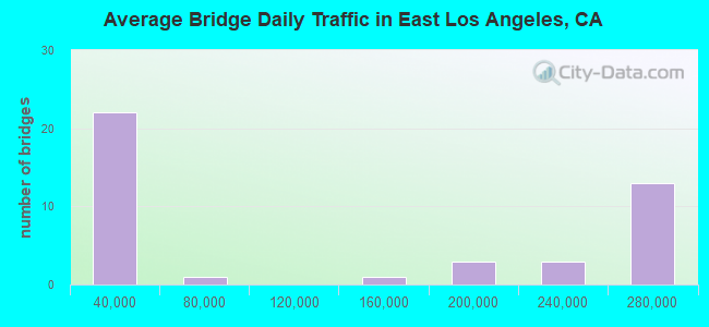
Bridge Statistics for East Los Angeles, California (CA)
Condition, Traffic, Stress, Structural Evaluation, Project Costs
- National Bridge Inventory (NBI) Statistics
- 43Number of bridges
- 794ft / 242mTotal length
- 5,032,355Total average daily traffic
- 287,869Total average daily truck traffic
- National Bridge Inventory (NBI) Registered Bridges for East Los Angeles
- No street view available for this location
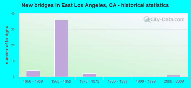
- New bridges - historical statistics
- 41950-1959
- 361960-1969
- 21970-1979
- 12000-2009
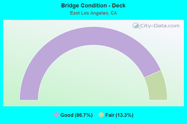
- Bridge Condition - Deck
- 86.7%Good
- 13.3%Fair
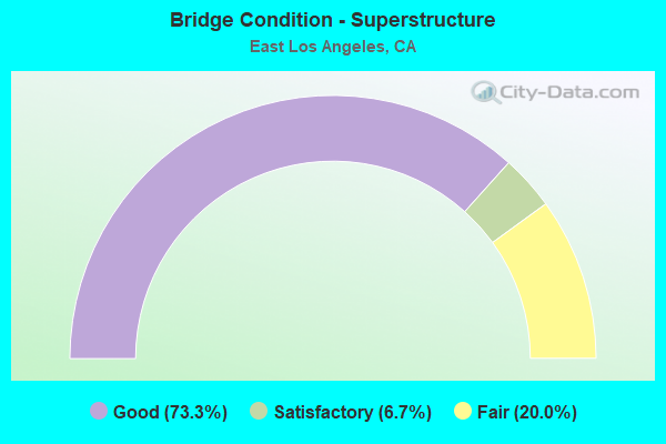
- Bridge Condition - Superstructure
- 73.3%Good
- 6.7%Satisfactory
- 20.0%Fair
Find on map >> Show street view
Structure Number: 53 0119, Location: 07-LA-060-R2.22 (Lat: 34.032067, Lng: -118.187489), Route carried "on" structure: County highway , Year Built: 1965, Status: Open, Structure Length: 7.22m (23.69ft), Average Daily Traffic: 2,050 (year 2015), Truck Traffic: 2%, Average Future Daily Traffic: 2,125 (year 2040), Design Load: HS 20, Features Intersected: ROUTE 60, Facility Carried by Structure: ROWAN AVE
Minimum Vertical Clearance: 30+ m (98+ ft), Kilometerpoint: 0.000, Lanes on structure: 2, Lanes under structure: 12, Owner: State Highway Agency, Approaching Roadway Width: 12.2m (40.0ft), Material/Design: Concrete continuous, Design/Construction: Box Beam or Girders - Multiple, Number Of Spans In Main Unit: 4, Length of Maximum Span: 25.0m (82.0ft), Curb or Sidewalk Widths: Left: 1.6m (5.2ft), Right: 1.6m (5.2ft), Curb-To-Curb Width: 12.2m (40.0ft), Out-to-Out Width: 15.9m (52.2ft)
Condition: Deck: Good, Superstructure: Fair, Substructure: Good, Operating Rating: 38.6 metric tons, Method Used To Determine Operating Rating: Load and Resistance Factor Rating (LRFR) rating reported by rating factor(RF) method using HL-93 loadings, Inventory Rating: 29.8 metric tons, Method Used To Determine Inventory Rating: Load and Resistance Factor Rating (LRFR) rating reported by rating factor(RF) method using HL-93 loadings, Structural Evaluation: Somewhat better than minimum adequacy, Deck Geometry: Equal to present minimum criteria, Underclear: High priority of corrective action, Approach Roadway Alignment: Equal to present desirable criteria, Designated Inspection Frequency: Every 24 months, Inspection Date: May 2021, Deck Structure Type: Concrete Cast-file-Place
Find on map >> Show street view
Structure Number: 53 0389, Location: 07-LA-060-R3.25 (Lat: 34.035403, Lng: -118.170283), Route carried "on" structure: State highway 60, Year Built: 1967, Status: Open, Structure Length: 6.83m (22.41ft), Average Daily Traffic: 241,000 (year 2019), Truck Traffic: 5%, Average Future Daily Traffic: 216,259 (year 2040), Design Load: HS 20, Features Intersected: INTERSTATE 710
Minimum Vertical Clearance: 4.57m (14.99ft), Kilometerpoint: 3.250, Lanes on structure: 8, Lanes under structure: 8, Base Highway Network: Yes (, Subroute: 1), Owner: State Highway Agency, Approaching Roadway Width: 40.8m (133.9ft), Skew: 31 degrees, Material/Design: Prestressed concrete, Design/Construction: Stringer/Multi-beam, Number Of Spans In Main Unit: 2, Number Of Approach Spans: 2, Length of Maximum Span: 22.3m (73.2ft), Curb-To-Curb Width: 39.1m (128.3ft), Out-to-Out Width: 42.3m (138.8ft)
Condition: Deck: Good, Superstructure: Good, Substructure: Good, Operating Rating: 59.3 metric tons, Method Used To Determine Operating Rating: Load and Resistance Factor Rating (LRFR) rating reported by rating factor(RF) method using HL-93 loadings, Inventory Rating: 39.9 metric tons, Method Used To Determine Inventory Rating: Load and Resistance Factor Rating (LRFR) rating reported by rating factor(RF) method using HL-93 loadings, Structural Evaluation: Better than present minimum criteria, Deck Geometry: Meets minimum limits, Underclear: Meets minimum limits, Approach Roadway Alignment: Equal to present desirable criteria, Designated Inspection Frequency: Every 24 months, Inspection Date: April 2021, Deck Structure Type: Concrete Cast-file-Place
Find on map >> Show street view
Structure Number: 53 0442, Location: 07-LA-060-R3.30 (Lat: 34.035539, Lng: -118.169447), Route carried "on" structure: State highway 60, Year Built: 1967, Status: Open, Structure Length: 5.24m (17.19ft), Average Daily Traffic: 261,000 (year 2019), Truck Traffic: 7%, Average Future Daily Traffic: 239,337 (year 2040), Design Load: HS 20, Features Intersected: FORD BLVD
Minimum Vertical Clearance: 30+ m (98+ ft), Kilometerpoint: 3.300, Lanes on structure: 8, Lanes under structure: 4, Base Highway Network: Yes (, Subroute: 1), Owner: State Highway Agency, Approaching Roadway Width: 41.5m (136.2ft), Skew: 31 degrees, Material/Design: Concrete continuous, Design/Construction: Box Beam or Girders - Multiple, Number Of Spans In Main Unit: 4, Length of Maximum Span: 16.2m (53.1ft), Curb-To-Curb Width: 41.1m (134.8ft), Out-to-Out Width: 42.3m (138.8ft)
Condition: Deck: Good, Superstructure: Good, Substructure: Good, Operating Rating: 28.5 metric tons, Method Used To Determine Operating Rating: Load and Resistance Factor Rating (LRFR) rating reported by rating factor(RF) method using HL-93 loadings, Inventory Rating: 22.0 metric tons, Method Used To Determine Inventory Rating: Load and Resistance Factor Rating (LRFR) rating reported by rating factor(RF) method using HL-93 loadings, Structural Evaluation: Somewhat better than minimum adequacy, Deck Geometry: Superior to present desirable criteria, Underclear: Meets minimum limits, Approach Roadway Alignment: Equal to present desirable criteria, Length Of Structure Improvement: 5.24m (17.19ft), Designated Inspection Frequency: Every 24 months, Inspection Date: April 2021, Deck Structure Type: Concrete Cast-file-Place
Find on map >> Show street view
Structure Number: 53 0446K, Location: 07-LA-060-R2.54 (Lat: 34.033131, Lng: -118.181914), Route carried "on" structure: Bypass State highway 60, Year Built: 1965, Status: Open, Structure Length: 5.53m (18.14ft), Average Daily Traffic: 5,200 (year 2019), Truck Traffic: 2%, Average Future Daily Traffic: 7,082 (year 2040), Design Load: HS 20, Features Intersected: 3RD STREET
Minimum Vertical Clearance: 30+ m (98+ ft), Kilometerpoint: 2.540, Lanes on structure: 2, Lanes under structure: 5, Base Highway Network: Yes (, Subroute: 1), Owner: State Highway Agency, Approaching Roadway Width: 8.5m (27.9ft), Skew: 1 degrees, Material/Design: Concrete continuous, Design/Construction: Box Beam or Girders - Multiple, Number Of Spans In Main Unit: 4, Length of Maximum Span: 17.4m (57.1ft), Curb or Sidewalk Widths: Left: 0.6m (2.0ft), Right: 0.6m (2.0ft), Curb-To-Curb Width: 8.5m (27.9ft), Out-to-Out Width: 10.4m (34.1ft)
Condition: Deck: Good, Superstructure: Good, Substructure: Good, Operating Rating: 38.9 metric tons, Method Used To Determine Operating Rating: Load and Resistance Factor Rating (LRFR) rating reported by rating factor(RF) method using HL-93 loadings, Inventory Rating: 30.1 metric tons, Method Used To Determine Inventory Rating: Load and Resistance Factor Rating (LRFR) rating reported by rating factor(RF) method using HL-93 loadings, Structural Evaluation: Better than present minimum criteria, Deck Geometry: High priority of replacement, Underclear: Meets minimum limits, Approach Roadway Alignment: Equal to present desirable criteria, Designated Inspection Frequency: Every 24 months, Inspection Date: May 2021, Deck Structure Type: Concrete Cast-file-Place
Find on map >> Show street view
Structure Number: 53 0606, Location: 07-LA-005-14.16 (Lat: 34.018747, Lng: -118.178844), Route carried "on" structure: County highway L183, Year Built: 1951, Status: Open, Structure Length: 12.70m (41.67ft), Average Daily Traffic: 25,800 (year 2019), Truck Traffic: 6%, Average Future Daily Traffic: 36,145 (year 2038), Design Load: HS 20, Features Intersected: ROUTE 5, Facility Carried by Structure: OLYMPIC BLVD
Minimum Vertical Clearance: 30+ m (98+ ft), Kilometerpoint: 0.000, Lanes on structure: 5, Lanes under structure: 11, Base Highway Network: Yes, Owner: State Highway Agency, Approaching Roadway Width: 21.3m (69.9ft), Skew: 6 degrees, Material/Design: Concrete continuous, Design/Construction: Box Beam or Girders - Multiple, Number Of Spans In Main Unit: 4, Length of Maximum Span: 44.5m (146.0ft), Curb or Sidewalk Widths: Left: 1.8m (5.9ft), Right: 1.8m (5.9ft), Curb-To-Curb Width: 21.3m (69.9ft), Out-to-Out Width: 25.8m (84.6ft)
Condition: Deck: Good, Superstructure: Satisfactory, Substructure: Good, Operating Rating: 99.8 metric tons, Method Used To Determine Operating Rating: Load Factor (LF), Inventory Rating: 70.7 metric tons, Method Used To Determine Inventory Rating: Load Factor (LF), Structural Evaluation: Equal to present minimum criteria, Deck Geometry: Somewhat better than minimum adequacy, Underclear: High priority of corrective action, Approach Roadway Alignment: Equal to present desirable criteria, Designated Inspection Frequency: Every 24 months, Inspection Date: January 2021, Deck Structure Type: Concrete Cast-file-Place
Find on map >> Show street view
Structure Number: 53 0756S, Location: 07-LA-060-R2.39 (Lat: 34.032275, Lng: -118.184697), Route carried "on" structure: Ramp County highway , Year Built: 1965, Status: Open, Structure Length: 8.11m (26.61ft), Average Daily Traffic: 5,030 (year 2015), Truck Traffic: 2%, Average Future Daily Traffic: 6,286 (year 2040), Design Load: HS 20, Features Intersected: ROUTE 60, Facility Carried by Structure: 3RD ST ON-RAMP
Minimum Vertical Clearance: 30+ m (98+ ft), Kilometerpoint: 0.000, Lanes on structure: 2, Lanes under structure: 11, Base Highway Network: Yes, Owner: State Highway Agency, Approaching Roadway Width: 8.5m (27.9ft), Skew: 9 degrees, Material/Design: Concrete continuous, Design/Construction: Box Beam or Girders - Multiple, Number Of Spans In Main Unit: 4, Length of Maximum Span: 27.1m (88.9ft), Curb or Sidewalk Widths: Left: 0.6m (2.0ft), Right: 0.6m (2.0ft), Curb-To-Curb Width: 8.5m (27.9ft), Out-to-Out Width: 10.4m (34.1ft)
Condition: Deck: Good, Superstructure: Good, Substructure: Good, Operating Rating: 61.6 metric tons, Method Used To Determine Operating Rating: Load Factor (LF), Inventory Rating: 37.2 metric tons, Method Used To Determine Inventory Rating: Load Factor (LF), Structural Evaluation: Better than present minimum criteria, Deck Geometry: High priority of corrective action, Underclear: High priority of corrective action, Approach Roadway Alignment: Equal to present desirable criteria, Designated Inspection Frequency: Every 48 months, Inspection Date: May 2021, Deck Structure Type: Concrete Cast-file-Place
Find on map >> Show street view
Structure Number: 53 0772, Location: 07-LA-060-R2.75 (Lat: 34.033886, Lng: -118.178983), Route carried "on" structure: State highway 60, Year Built: 1967, Year Reconstructed: 2004, Status: Open, Structure Length: 4.75m (15.58ft), Average Daily Traffic: 241,000 (year 2019), Truck Traffic: 5%, Average Future Daily Traffic: 268,000 (year 2040), Design Load: HS 20, Features Intersected: SUNOL DR
Minimum Vertical Clearance: 30+ m (98+ ft), Kilometerpoint: 2.750, Lanes on structure: 12, Lanes under structure: 2, Base Highway Network: Yes (, Subroute: 1), Owner: State Highway Agency, Approaching Roadway Width: 42.4m (139.1ft), Skew: 32 degrees, Material/Design: Concrete continuous, Design/Construction: Box Beam or Girders - Multiple, Number Of Spans In Main Unit: 3, Length of Maximum Span: 22.9m (75.1ft), Curb or Sidewalk Widths: Left: 0.6m (2.0ft), Right: 0.6m (2.0ft), Curb-To-Curb Width: 42.4m (139.1ft), Out-to-Out Width: 51.0m (167.3ft)
Condition: Deck: Good, Superstructure: Good, Substructure: Good, Operating Rating: 58.0 metric tons, Method Used To Determine Operating Rating: Load Factor (LF), Inventory Rating: 35.4 metric tons, Method Used To Determine Inventory Rating: Load Factor (LF), Structural Evaluation: Better than present minimum criteria, Deck Geometry: High priority of replacement, Underclear: Equal to present desirable criteria, Approach Roadway Alignment: Equal to present desirable criteria, Designated Inspection Frequency: Every 24 months, Inspection Date: May 2021, Deck Structure Type: Concrete Cast-file-Place
Find on map >> Show street view
Structure Number: 53 0775, Location: 07-LA-060-R3.06 (Lat: 34.035344, Lng: -118.173686), Route carried "on" structure: County highway L359, Year Built: 1967, Status: Open, Structure Length: 7.10m (23.29ft), Average Daily Traffic: 14,000 (year 2015), Truck Traffic: 2%, Average Future Daily Traffic: 16,486 (year 2040), Design Load: HS 20, Features Intersected: STATE ROUTE 60, Facility Carried by Structure: EASTERN AVE
Minimum Vertical Clearance: 30+ m (98+ ft), Kilometerpoint: 0.000, Lanes on structure: 2, Lanes under structure: 12, Owner: State Highway Agency, Approaching Roadway Width: 18.9m (62.0ft), Skew: 1 degrees, Material/Design: Concrete continuous, Design/Construction: Box Beam or Girders - Multiple, Number Of Spans In Main Unit: 3, Length of Maximum Span: 32.9m (107.9ft), Curb or Sidewalk Widths: Left: 1.5m (4.9ft), Right: 1.5m (4.9ft), Curb-To-Curb Width: 18.9m (62.0ft), Out-to-Out Width: 24.1m (79.1ft)
Condition: Deck: Good, Superstructure: Fair, Substructure: Good, Operating Rating: 32.1 metric tons, Method Used To Determine Operating Rating: Load and Resistance Factor Rating (LRFR) rating reported by rating factor(RF) method using HL-93 loadings, Inventory Rating: 24.9 metric tons, Method Used To Determine Inventory Rating: Load and Resistance Factor Rating (LRFR) rating reported by rating factor(RF) method using HL-93 loadings, Structural Evaluation: Somewhat better than minimum adequacy, Deck Geometry: Superior to present desirable criteria, Underclear: High priority of corrective action, Approach Roadway Alignment: Equal to present desirable criteria, Designated Inspection Frequency: Every 24 months, Inspection Date: April 2021, Deck Structure Type: Concrete Cast-file-Place
Find on map >> Show street view
Structure Number: 53 0784, Location: 07-LA-005-14.25 (Lat: 34.019283, Lng: -118.179972), Route carried "on" structure: County highway , Year Built: 1951, Status: Open, Structure Length: 6.49m (21.29ft), Average Daily Traffic: 6,500 (year 2019), Truck Traffic: 1%, Average Future Daily Traffic: 11,128 (year 2038), Design Load: HS 20, Features Intersected: INTERSTATE 5, Facility Carried by Structure: DOWNEY ROAD
Minimum Vertical Clearance: 30+ m (98+ ft), Kilometerpoint: 0.000, Lanes on structure: 2, Lanes under structure: 10, Owner: State Highway Agency, Approaching Roadway Width: 12.2m (40.0ft), Skew: 2 degrees, Material/Design: Concrete continuous, Design/Construction: Box Beam or Girders - Multiple, Number Of Spans In Main Unit: 2, Length of Maximum Span: 21.3m (69.9ft), Curb or Sidewalk Widths: Left: 1.5m (4.9ft), Right: 1.5m (4.9ft), Curb-To-Curb Width: 12.2m (40.0ft), Out-to-Out Width: 16.0m (52.5ft)
Condition: Deck: Fair, Superstructure: Good, Substructure: Good, Operating Rating: 35.3 metric tons, Method Used To Determine Operating Rating: Load and Resistance Factor Rating (LRFR) rating reported by rating factor(RF) method using HL-93 loadings, Inventory Rating: 27.2 metric tons, Method Used To Determine Inventory Rating: Load and Resistance Factor Rating (LRFR) rating reported by rating factor(RF) method using HL-93 loadings, Structural Evaluation: Equal to present minimum criteria, Deck Geometry: Somewhat better than minimum adequacy, Underclear: High priority of corrective action, Approach Roadway Alignment: Superior to present desirable criteria, Designated Inspection Frequency: Every 24 months, Inspection Date: January 2021, Deck Structure Type: Concrete Cast-file-Place
Find on map >> Show street view
Structure Number: 53 1696, Location: 07-LA-060-R4.80 (Lat: 34.032875, Lng: -118.144403), Route carried "on" structure: State highway 60, Year Built: 1967, Year Reconstructed: 2004, Status: Open, Structure Length: 4.63m (15.19ft), Average Daily Traffic: 250,000 (year 2019), Truck Traffic: 7%, Average Future Daily Traffic: 289,337 (year 2039), Design Load: HS 20, Features Intersected: GERHART AVE
Minimum Vertical Clearance: 30+ m (98+ ft), Kilometerpoint: 4.800, Lanes on structure: 12, Lanes under structure: 4, Base Highway Network: Yes (, Subroute: 1), Owner: State Highway Agency, Approaching Roadway Width: 54.3m (178.1ft), Skew: 30 degrees, Material/Design: Concrete continuous, Design/Construction: Box Beam or Girders - Multiple, Number Of Spans In Main Unit: 3, Length of Maximum Span: 25.0m (82.0ft), Curb or Sidewalk Widths: Left: 0.6m (2.0ft), Right: 0.6m (2.0ft), Curb-To-Curb Width: 54.3m (178.1ft), Out-to-Out Width: 55.3m (181.4ft)
Condition: Deck: Fair, Superstructure: Good, Substructure: Good, Operating Rating: 63.8 metric tons, Method Used To Determine Operating Rating: Load Factor (LF), Inventory Rating: 38.2 metric tons, Method Used To Determine Inventory Rating: Load Factor (LF), Structural Evaluation: Better than present minimum criteria, Deck Geometry: Superior to present desirable criteria, Underclear: Somewhat better than minimum adequacy, Approach Roadway Alignment: Equal to present desirable criteria, Length Of Structure Improvement: 4.63m (15.19ft), Designated Inspection Frequency: Every 24 months, Inspection Date: April 2021, Deck Structure Type: Concrete Cast-file-Place
Find on map >> Show street view
Structure Number: 53 1715H, Location: 07-LA-060-R3.28-EALA (Lat: 34.034653, Lng: -118.171292), Route carried "on" structure: Ramp State highway 60, Year Built: 1967, Status: Open, Structure Length: 56.45m (185.20ft), Average Daily Traffic: 27,000 (year 2017), Truck Traffic: 7%, Average Future Daily Traffic: 42,200 (year 2039), Design Load: HS 20, Features Intersected: RTE60/710,FORD ST,3RDST
Minimum Vertical Clearance: 99.90m (327.76ft), Kilometerpoint: 3.280, Lanes on structure: 1, Lanes under structure: 26, Base Highway Network: Yes (, Subroute: 1), Owner: State Highway Agency, Approaching Roadway Width: 6.7m (22.0ft), Skew: 9 degrees, Material/Design: Concrete continuous, Design/Construction: Box Beam or Girders - Multiple, Number Of Spans In Main Unit: 17, Number Of Approach Spans: 1, Length of Maximum Span: 37.8m (124.0ft), Curb or Sidewalk Widths: Left: 0.6m (2.0ft), Right: 0.6m (2.0ft), Curb-To-Curb Width: 6.8m (22.3ft), Out-to-Out Width: 11.8m (38.7ft)
Condition: Deck: Good, Superstructure: Good, Substructure: Good, Operating Rating: 66.4 metric tons, Method Used To Determine Operating Rating: Load Factor (LF), Inventory Rating: 39.9 metric tons, Method Used To Determine Inventory Rating: Load Factor (LF), Structural Evaluation: Better than present minimum criteria, Deck Geometry: High priority of corrective action, Underclear: High priority of corrective action, Approach Roadway Alignment: Equal to present desirable criteria, Designated Inspection Frequency: Every 24 months, Inspection Date: April 2021, Deck Structure Type: Concrete Cast-file-Place
Find on map >> Show street view
Structure Number: 53 1717H, Location: 07-LA-060-R3.26 (Lat: 34.035053, Lng: -118.171128), Route carried "on" structure: Ramp State highway 60, Year Built: 1967, Status: Open, Structure Length: 83.70m (274.61ft), Average Daily Traffic: 13,800 (year 2017), Truck Traffic: 7%, Average Future Daily Traffic: 20,954 (year 2039), Design Load: HS 20, Features Intersected: RTE 60/710,RAMP,3STREETS
Minimum Vertical Clearance: 4.62m (15.16ft), Kilometerpoint: 3.260, Lanes on structure: 2, Lanes under structure: 33, Base Highway Network: Yes (, Subroute: 1), Owner: State Highway Agency, Approaching Roadway Width: 6.7m (22.0ft), Skew: 9 degrees, Material/Design: Concrete continuous, Design/Construction: Box Beam or Girders - Multiple, Number Of Spans In Main Unit: 27, Length of Maximum Span: 37.2m (122.0ft), Curb or Sidewalk Widths: Left: 0.6m (2.0ft), Right: 0.6m (2.0ft), Curb-To-Curb Width: 10.5m (34.4ft), Out-to-Out Width: 11.7m (38.4ft)
Condition: Deck: Good, Superstructure: Fair, Substructure: Good, Operating Rating: 76.5 metric tons, Method Used To Determine Operating Rating: Load Factor (LF), Inventory Rating: 46.0 metric tons, Method Used To Determine Inventory Rating: Load Factor (LF), Structural Evaluation: Somewhat better than minimum adequacy, Deck Geometry: Meets minimum limits, Underclear: High priority of corrective action, Approach Roadway Alignment: High priority of corrective action, Designated Inspection Frequency: Every 24 months, Inspection Date: April 2021, Deck Structure Type: Concrete Cast-file-Place
Find on map >> Show street view
Structure Number: 53 1734, Location: 07-LA-060-R3.74 (Lat: 34.036892, Lng: -118.161986), Route carried "on" structure: City street L361, Year Built: 1967, Status: Open, Structure Length: 7.77m (25.49ft), Average Daily Traffic: 12,300 (year 2019), Truck Traffic: 2%, Average Future Daily Traffic: 13,395 (year 2041), Design Load: HS 20, Features Intersected: STATE ROUTE 60, Facility Carried by Structure: MEDNIK AVE
Minimum Vertical Clearance: 30+ m (98+ ft), Kilometerpoint: 0.000, Lanes on structure: 4, Lanes under structure: 12, Owner: State Highway Agency, Approaching Roadway Width: 18.3m (60.0ft), Material/Design: Concrete continuous, Design/Construction: Box Beam or Girders - Multiple, Number Of Spans In Main Unit: 4, Length of Maximum Span: 29.3m (96.1ft), Curb or Sidewalk Widths: Left: 1.5m (4.9ft), Right: 1.5m (4.9ft), Curb-To-Curb Width: 19.5m (64.0ft), Out-to-Out Width: 24.8m (81.4ft)
Condition: Deck: Good, Superstructure: Good, Substructure: Good, Operating Rating: 38.6 metric tons, Method Used To Determine Operating Rating: Load and Resistance Factor Rating (LRFR) rating reported by rating factor(RF) method using HL-93 loadings, Inventory Rating: 29.8 metric tons, Method Used To Determine Inventory Rating: Load and Resistance Factor Rating (LRFR) rating reported by rating factor(RF) method using HL-93 loadings, Structural Evaluation: Better than present minimum criteria, Deck Geometry: Better than present minimum criteria, Underclear: High priority of corrective action, Approach Roadway Alignment: Equal to present desirable criteria, Designated Inspection Frequency: Every 24 months, Inspection Date: April 2021, Deck Structure Type: Concrete Cast-file-Place
Find on map >> Show street view
Structure Number: 53 2039K, Location: 07-LA-010-20.20 (Lat: 34.055889, Lng: -118.184731), Route carried "on" structure: Ramp Interstate 10, Year Built: 1972, Status: Open, Structure Length: 13.23m (43.41ft), Average Daily Traffic: 6,200 (year 2011), Truck Traffic: 1%, Average Future Daily Traffic: 7,267 (year 2040), Design Load: HS 20, Features Intersected: EMBANKMENT
Minimum Vertical Clearance: 30+ m (98+ ft), Kilometerpoint: 20.200, Lanes on structure: 1, Owner: State Highway Agency, Approaching Roadway Width: 7.3m (24.0ft), Material/Design: Concrete continuous, Design/Construction: Box Beam or Girders - Multiple, Number Of Spans In Main Unit: 5, Length of Maximum Span: 29.6m (97.1ft), Curb-To-Curb Width: 7.3m (24.0ft), Out-to-Out Width: 7.9m (25.9ft)
Condition: Deck: Good, Superstructure: Good, Substructure: Good, Operating Rating: 22.7 metric tons, Method Used To Determine Operating Rating: Load and Resistance Factor Rating (LRFR) rating reported by rating factor(RF) method using HL-93 loadings, Inventory Rating: 17.5 metric tons, Method Used To Determine Inventory Rating: Load and Resistance Factor Rating (LRFR) rating reported by rating factor(RF) method using HL-93 loadings, Structural Evaluation: Meets minimum limits, Deck Geometry: Better than present minimum criteria, Approach Roadway Alignment: Meets minimum limits, Designated Inspection Frequency: Every 24 months, Inspection Date: January 2021, Deck Structure Type: Concrete Cast-file-Place
Find on map >> Show street view
Structure Number: 53 2056S, Location: 07-LA-010-20.90 (Lat: 34.060328, Lng: -118.173181), Route carried "on" structure: Ramp Interstate 10, Year Built: 1972, Status: Open, Structure Length: 12.41m (40.72ft), Average Daily Traffic: 6,479 (year 2005), Truck Traffic: 1%, Average Future Daily Traffic: 9,550 (year 2040), Design Load: HS 20, Features Intersected: EMBANKMENT
Minimum Vertical Clearance: 30+ m (98+ ft), Kilometerpoint: 20.900, Lanes on structure: 2, Owner: State Highway Agency, Approaching Roadway Width: 9.8m (32.2ft), Material/Design: Concrete continuous, Design/Construction: Box Beam or Girders - Multiple, Number Of Spans In Main Unit: 5, Length of Maximum Span: 27.4m (89.9ft), Curb-To-Curb Width: 9.8m (32.2ft), Out-to-Out Width: 10.4m (34.1ft)
Condition: Deck: Good, Superstructure: Good, Substructure: Good, Operating Rating: 52.5 metric tons, Method Used To Determine Operating Rating: Load and Resistance Factor Rating (LRFR) rating reported by rating factor(RF) method using HL-93 loadings, Inventory Rating: 37.9 metric tons, Method Used To Determine Inventory Rating: Load and Resistance Factor Rating (LRFR) rating reported by rating factor(RF) method using HL-93 loadings, Structural Evaluation: Better than present minimum criteria, Deck Geometry: Equal to present minimum criteria, Approach Roadway Alignment: Meets minimum limits, Designated Inspection Frequency: Every 48 months, Inspection Date: December 2018, Deck Structure Type: Concrete Cast-file-Place
Find on map >> Show street view
Structure Number: 53 0119, Location: 07-LA-060-R2.22 (Lat: 34.032067, Lng: -118.187489), Route carried "under" structure: State highway 60, Year Built: 1965, Structure Length: 0. m, Average Daily Traffic: 239,000 (year 2019), Truck Traffic: 5%, Features Intersected: ROUTE 60, Facility Carried by Structure: ROWAN AVE
Minimum Vertical Clearance: 4.70m (15.42ft), Kilometerpoint: 2.220, Lanes on structure: 2, Lanes under structure: 12, Material/Design: Concrete continuous, Design/Construction: Box Beam or Girders - Multiple, Length of Maximum Span: 25.0m (82.0ft)
Find on map >> Show street view
Structure Number: 53 0389, Location: 07-LA-060-R3.25 (Lat: 34.035403, Lng: -118.170283), Route carried "under" structure: Interstate 710, Year Built: 1967, Structure Length: 0. m, Average Daily Traffic: 127,000 (year 2015), Truck Traffic: 5%, Features Intersected: INTERSTATE 710, Facility Carried by Structure: STATE ROUTE 60
Minimum Vertical Clearance: 4.57m (14.99ft), Kilometerpoint: 24.630, Lanes on structure: 8, Lanes under structure: 8, Material/Design: Prestressed concrete, Design/Construction: Stringer/Multi-beam, Length of Maximum Span: 22.3m (73.2ft)
Find on map >> Show street view
Structure Number: 53 0442, Location: 07-LA-060-R3.30 (Lat: 34.035539, Lng: -118.169447), Route carried "under" structure: City street L713, Year Built: 1967, Structure Length: 0. m, Average Daily Traffic: 5,264 (year 2015), Truck Traffic: 2%, Features Intersected: FORD BLVD, Facility Carried by Structure: STATE ROUTE 60
Minimum Vertical Clearance: 4.72m (15.49ft), Kilometerpoint: 0.000, Lanes on structure: 8, Lanes under structure: 4, Material/Design: Concrete continuous, Design/Construction: Box Beam or Girders - Multiple, Length of Maximum Span: 16.2m (53.1ft)
Find on map >> Show street view
Structure Number: 53 0446K, Location: 07-LA-060-R2.54 (Lat: 34.033131, Lng: -118.181914), Route carried "under" structure: County highway L700, Year Built: 1965, Structure Length: 0. m, Average Daily Traffic: 18,050 (year 2015), Truck Traffic: 2%, Features Intersected: 3RD STREET, Facility Carried by Structure: 3RD ST-W60 ON-RAMP
Minimum Vertical Clearance: 4.90m (16.08ft), Kilometerpoint: 0.000, Lanes on structure: 2, Lanes under structure: 5, Material/Design: Concrete continuous, Design/Construction: Box Beam or Girders - Multiple, Length of Maximum Span: 17.4m (57.1ft)
Find on map >> Show street view
Structure Number: 53 0606, Location: 07-LA-005-14.16 (Lat: 34.018747, Lng: -118.178844), Route carried "under" structure: Interstate 5, Year Built: 1951, Structure Length: 0. m, Average Daily Traffic: 251,000 (year 2019), Truck Traffic: 7%, Features Intersected: ROUTE 5, Facility Carried by Structure: OLYMPIC BLVD
Minimum Vertical Clearance: 4.57m (14.99ft), Kilometerpoint: 14.160, Lanes on structure: 5, Lanes under structure: 11, Material/Design: Concrete continuous, Design/Construction: Box Beam or Girders - Multiple, Length of Maximum Span: 44.5m (146.0ft)
Find on map >> Show street view
Structure Number: 53 0756S, Location: 07-LA-060-R2.39 (Lat: 34.032275, Lng: -118.184697), Route carried "under" structure: State highway 60, Year Built: 1965, Structure Length: 0. m, Average Daily Traffic: 239,000 (year 2019), Truck Traffic: 2%, Features Intersected: ROUTE 60, Facility Carried by Structure: 3RD ST ON-RAMP
Minimum Vertical Clearance: 4.88m (16.01ft), Kilometerpoint: 2.390, Lanes on structure: 2, Lanes under structure: 11, Material/Design: Concrete continuous, Design/Construction: Box Beam or Girders - Multiple, Length of Maximum Span: 27.1m (88.9ft)
Find on map >> Show street view
Structure Number: 53 0771, Location: 07-LA-060-R2.59 (Lat: 34.033097, Lng: -118.180856), Route carried "under" structure: County highway L700, Year Built: 1965, Structure Length: 0. m, Average Daily Traffic: 18,050 (year 2015), Truck Traffic: 2%, Features Intersected: THIRD STREET, Facility Carried by Structure: STATE ROUTE 60
Minimum Vertical Clearance: 4.65m (15.26ft), Kilometerpoint: 0.000, Lanes on structure: 11, Lanes under structure: 6, Material/Design: Concrete continuous, Design/Construction: Box Beam or Girders - Multiple, Length of Maximum Span: 31.4m (103.0ft)
Find on map >> Show street view
Structure Number: 53 0774, Location: 07-LA-060-R2.94 (Lat: 34.035086, Lng: -118.175650), Route carried "under" structure: State highway 60, Year Built: 1967, Structure Length: 0. m, Average Daily Traffic: 249,000 (year 2017), Truck Traffic: 5%, Features Intersected: STATE ROUTE 60, Facility Carried by Structure: PEDESTRIAN WALKWAY
Minimum Vertical Clearance: 10.36m (33.99ft), Kilometerpoint: 2.940, Lanes under structure: 12, Material/Design: Concrete continuous, Design/Construction: Stringer/Multi-beam, Length of Maximum Span: 32.3m (106.0ft)
Find on map >> Show street view
Structure Number: 53 0775, Location: 07-LA-060-R3.06 (Lat: 34.035344, Lng: -118.173686), Route carried "under" structure: State highway 60, Year Built: 1967, Structure Length: 0. m, Average Daily Traffic: 62,000 (year 2019), Truck Traffic: 5%, Features Intersected: STATE ROUTE 60, Facility Carried by Structure: EASTERN AVE
Minimum Vertical Clearance: 4.62m (15.16ft), Kilometerpoint: 3.060, Lanes on structure: 2, Lanes under structure: 2, Material/Design: Concrete continuous, Design/Construction: Box Beam or Girders - Multiple, Length of Maximum Span: 32.9m (107.9ft)
Find on map >> Show street view
Structure Number: 53 0775, Location: 07-LA-060-R3.06 (Lat: 34.035344, Lng: -118.173686), Route carried "under" structure: State highway 60, Year Built: 1967, Structure Length: 0. m, Average Daily Traffic: 241,000 (year 2019), Truck Traffic: 5%, Features Intersected: STATE ROUTE 60, Facility Carried by Structure: EASTERN AVE
Minimum Vertical Clearance: 4.95m (16.24ft), Kilometerpoint: 3.060, Lanes on structure: 2, Lanes under structure: 10, Material/Design: Concrete continuous, Design/Construction: Box Beam or Girders - Multiple, Length of Maximum Span: 32.9m (107.9ft)
Find on map >> Show street view
Structure Number: 53 0784, Location: 07-LA-005-14.25 (Lat: 34.019283, Lng: -118.179972), Route carried "under" structure: Interstate 5, Year Built: 1951, Structure Length: 0. m, Average Daily Traffic: 251,000 (year 2019), Truck Traffic: 7%, Features Intersected: INTERSTATE 5, Facility Carried by Structure: DOWNEY ROAD
Minimum Vertical Clearance: 4.52m (14.83ft), Kilometerpoint: 14.250, Lanes on structure: 2, Lanes under structure: 10, Material/Design: Concrete continuous, Design/Construction: Box Beam or Girders - Multiple, Length of Maximum Span: 21.3m (69.9ft)
Find on map >> Show street view
Structure Number: 53 1446, Location: 07-LA-060-R3.60 (Lat: 34.036861, Lng: -118.164775), Route carried "under" structure: State highway 60, Year Built: 1967, Structure Length: 0. m, Average Daily Traffic: 231,000 (year 2009), Truck Traffic: 7%, Features Intersected: STATE ROUTE 60, Facility Carried by Structure: PEDESTRIAN WALKWAY
Minimum Vertical Clearance: 6.30m (20.67ft), Kilometerpoint: 3.600, Lanes under structure: 13, Material/Design: Concrete continuous, Design/Construction: Stringer/Multi-beam, Length of Maximum Span: 21.3m (69.9ft)
Find on map >> Show street view
Structure Number: 53 1715H, Location: 07-LA-060-R3.28-EALA (Lat: 34.034653, Lng: -118.171292), Route carried "under" structure: Interstate 710, Year Built: 1967, Structure Length: 0. m, Average Daily Traffic: 198,000 (year 2017), Truck Traffic: 5%, Features Intersected: RTE60/710,FORD ST,3RDST
Minimum Vertical Clearance: 7.62m (25.00ft), Kilometerpoint: 24.620, Lanes on structure: 1, Lanes under structure: 6, Material/Design: Concrete continuous, Design/Construction: Box Beam or Girders - Multiple, Length of Maximum Span: 37.8m (124.0ft)
Find on map >> Show street view
Structure Number: 53 1715H, Location: 07-LA-060-R3.28-EALA (Lat: 34.034653, Lng: -118.171292), Route carried "under" structure: Bypass Interstate 710, Year Built: 1967, Structure Length: 0. m, Average Daily Traffic: 2,900 (year 2017), Truck Traffic: 8%, Features Intersected: RTE60/710,FORD ST,3RDST
Minimum Vertical Clearance: 4.67m (15.32ft), Kilometerpoint: 24.620, Lanes on structure: 1, Lanes under structure: 2, Material/Design: Concrete continuous, Design/Construction: Box Beam or Girders - Multiple, Length of Maximum Span: 37.8m (124.0ft)
Find on map >> Show street view
Structure Number: 53 1715H, Location: 07-LA-060-R3.28-EALA (Lat: 34.034653, Lng: -118.171292), Route carried "under" structure: City street L713, Year Built: 1967, Structure Length: 0. m, Average Daily Traffic: 5,564 (year 2017), Truck Traffic: 2%, Features Intersected: RTE60/710,FORD ST,3RDST, Facility Carried by Structure: E&W60-S710 CONNCTR
Minimum Vertical Clearance: 9.14m (29.99ft), Kilometerpoint: 0.000, Lanes on structure: 1, Lanes under structure: 4, Material/Design: Concrete continuous, Design/Construction: Box Beam or Girders - Multiple, Length of Maximum Span: 37.8m (124.0ft)
Find on map >> Show street view
Structure Number: 53 1715H, Location: 07-LA-060-R3.28-EALA (Lat: 34.034653, Lng: -118.171292), Route carried "under" structure: State highway 60, Year Built: 1967, Structure Length: 0. m, Average Daily Traffic: 264,000 (year 2017), Truck Traffic: 7%, Features Intersected: RTE60/710,FORD ST,3RDST
Minimum Vertical Clearance: 4.72m (15.49ft), Kilometerpoint: 3.280, Lanes on structure: 1, Lanes under structure: 8, Material/Design: Concrete continuous, Design/Construction: Box Beam or Girders - Multiple, Length of Maximum Span: 37.8m (124.0ft)
Find on map >> Show street view
Structure Number: 53 1715H, Location: 07-LA-060-R3.28-EALA (Lat: 34.034653, Lng: -118.171292), Route carried "under" structure: City street L700, Year Built: 1967, Structure Length: 0. m, Average Daily Traffic: 25,768 (year 2017), Truck Traffic: 2%, Features Intersected: RTE60/710,FORD ST,3RDST, Facility Carried by Structure: E&W60-S710 CONNCTR
Minimum Vertical Clearance: 4.57m (14.99ft), Kilometerpoint: 0.000, Lanes on structure: 1, Lanes under structure: 6, Material/Design: Concrete continuous, Design/Construction: Box Beam or Girders - Multiple, Length of Maximum Span: 37.8m (124.0ft)
Find on map >> Show street view
Structure Number: 53 1717H, Location: 07-LA-060-R3.26 (Lat: 34.035053, Lng: -118.171128), Route carried "under" structure: City street L245, Year Built: 1967, Structure Length: 0. m, Average Daily Traffic: 20,000 (year 2019), Truck Traffic: 2%, Features Intersected: RTE 60/710,RAMP,3STREETS, Facility Carried by Structure: E&W60-N710 CONNCTR
Minimum Vertical Clearance: 5.46m (17.91ft), Kilometerpoint: 0.000, Lanes on structure: 2, Lanes under structure: 3, Material/Design: Concrete continuous, Design/Construction: Box Beam or Girders - Multiple, Length of Maximum Span: 37.2m (122.0ft)
Find on map >> Show street view
Structure Number: 53 1717H, Location: 07-LA-060-R3.26 (Lat: 34.035053, Lng: -118.171128), Route carried "under" structure: Ramp Interstate 710, Year Built: 1967, Structure Length: 0. m, Average Daily Traffic: 5,000 (year 2019), Truck Traffic: 2%, Features Intersected: RTE 60/710,RAMP,3STREETS
Minimum Vertical Clearance: 5.82m (19.09ft), Kilometerpoint: 24.820, Lanes on structure: 2, Lanes under structure: 2, Material/Design: Concrete continuous, Design/Construction: Box Beam or Girders - Multiple, Length of Maximum Span: 37.2m (122.0ft)
Find on map >> Show street view
Structure Number: 53 1717H, Location: 07-LA-060-R3.26 (Lat: 34.035053, Lng: -118.171128), Route carried "under" structure: City street L245, Year Built: 1967, Structure Length: 0. m, Average Daily Traffic: 14,000 (year 2019), Truck Traffic: 2%, Features Intersected: RTE 60/710,RAMP,3STREETS, Facility Carried by Structure: E&W60-N710 CONNCTR
Minimum Vertical Clearance: 5.46m (17.91ft), Kilometerpoint: 0.000, Lanes on structure: 2, Lanes under structure: 5, Material/Design: Concrete continuous, Design/Construction: Box Beam or Girders - Multiple, Length of Maximum Span: 37.2m (122.0ft)
Find on map >> Show street view
Structure Number: 53 1717H, Location: 07-LA-060-R3.26 (Lat: 34.035053, Lng: -118.171128), Route carried "under" structure: Interstate 710, Year Built: 1967, Structure Length: 0. m, Average Daily Traffic: 198,000 (year 2017), Truck Traffic: 7%, Features Intersected: RTE 60/710,RAMP,3STREETS
Minimum Vertical Clearance: 7.62m (25.00ft), Kilometerpoint: 24.620, Lanes on structure: 2, Lanes under structure: 6, Material/Design: Concrete continuous, Design/Construction: Box Beam or Girders - Multiple, Length of Maximum Span: 37.2m (122.0ft)
Find on map >> Show street view
Structure Number: 53 1717H, Location: 07-LA-060-R3.26 (Lat: 34.035053, Lng: -118.171128), Route carried "under" structure: City street L713, Year Built: 1967, Structure Length: 0. m, Average Daily Traffic: 12,600 (year 2019), Truck Traffic: 2%, Features Intersected: RTE 60/710,RAMP,3STREETS, Facility Carried by Structure: E&W60-N710 CONNCTR
Minimum Vertical Clearance: 4.65m (15.26ft), Kilometerpoint: 0.000, Lanes on structure: 2, Lanes under structure: 5, Material/Design: Concrete continuous, Design/Construction: Box Beam or Girders - Multiple, Length of Maximum Span: 37.2m (122.0ft)
Find on map >> Show street view
Structure Number: 53 1717H, Location: 07-LA-060-R3.26 (Lat: 34.035053, Lng: -118.171128), Route carried "under" structure: City street L243, Year Built: 1967, Structure Length: 0. m, Average Daily Traffic: 19,800 (year 2019), Truck Traffic: 2%, Features Intersected: RTE 60/710,RAMP,3STREETS, Facility Carried by Structure: E&W60-N710 CONNCTR
Minimum Vertical Clearance: 4.72m (15.49ft), Kilometerpoint: 0.000, Lanes on structure: 2, Lanes under structure: 4, Material/Design: Concrete continuous, Design/Construction: Box Beam or Girders - Multiple, Length of Maximum Span: 37.2m (122.0ft)
Find on map >> Show street view
Structure Number: 53 1717H, Location: 07-LA-060-R3.26 (Lat: 34.035053, Lng: -118.171128), Route carried "under" structure: State highway 60, Year Built: 1967, Structure Length: 0. m, Average Daily Traffic: 264,000 (year 2017), Truck Traffic: 7%, Features Intersected: RTE 60/710,RAMP,3STREETS
Minimum Vertical Clearance: 4.57m (14.99ft), Kilometerpoint: 3.250, Lanes on structure: 2, Lanes under structure: 8, Material/Design: Concrete continuous, Design/Construction: Box Beam or Girders - Multiple, Length of Maximum Span: 37.2m (122.0ft)
Find on map >> Show street view
Structure Number: 53 1728, Location: 07-LA-060-R3.88 (Lat: 34.036894, Lng: -118.159294), Route carried "under" structure: State highway 60, Year Built: 1967, Structure Length: 0. m, Average Daily Traffic: 253,000 (year 2017), Features Intersected: STATE ROUTE 60, Facility Carried by Structure: PEDESTRIAN WALKWAY
Minimum Vertical Clearance: 5.64m (18.50ft), Kilometerpoint: 3.880, Lanes under structure: 12, Material/Design: Concrete continuous, Design/Construction: Stringer/Multi-beam, Length of Maximum Span: 25.0m (82.0ft)
Find on map >> Show street view
Structure Number: 53 1734, Location: 07-LA-060-R3.74 (Lat: 34.036892, Lng: -118.161986), Route carried "under" structure: State highway 60, Year Built: 1967, Structure Length: 0. m, Average Daily Traffic: 261,000 (year 2019), Truck Traffic: 7%, Features Intersected: STATE ROUTE 60, Facility Carried by Structure: MEDNIK AVE
Minimum Vertical Clearance: 4.52m (14.83ft), Kilometerpoint: 3.740, Lanes on structure: 4, Lanes under structure: 12, Material/Design: Concrete continuous, Design/Construction: Box Beam or Girders - Multiple, Length of Maximum Span: 29.3m (96.1ft)
Find on map >> Show street view
Structure Number: 53 187, Location: 07-LA-005-14.57 (Lat: 34.019961, Lng: -118.185942), Route carried "under" structure: Interstate 5, Year Built: 1967, Structure Length: 0. m, Average Daily Traffic: 258,000 (year 2009), Truck Traffic: 10%, Features Intersected: INTERSTATE 5, Facility Carried by Structure: PEDESTRIAN WALKWAY
Minimum Vertical Clearance: 5.00m (16.40ft), Kilometerpoint: 14.570, Lanes under structure: 12, Material/Design: Prestressed concrete, Design/Construction: Tee Beam, Length of Maximum Span: 19.8m (65.0ft)
Find on map >> Show street view
Structure Number: 53 2986, Location: 07-LA-710-24.47 (Lat: 34.033169, Lng: -118.170450), Route carried "under" structure: Interstate 710, Year Built: 2008, Structure Length: 0. m, Average Daily Traffic: 182,000 (year 2009), Truck Traffic: 7%, Features Intersected: INTERSTATE 710, Facility Carried by Structure: MTA RAIL
Minimum Vertical Clearance: 5.23m (17.16ft), Kilometerpoint: 24.470, Lanes under structure: 6, Material/Design: Concrete, Design/Construction: Box Beam or Girders - Multiple, Length of Maximum Span: 25.5m (83.7ft)