Bridge Statistics for Dundee, Michigan (MI)
Condition, Traffic, Stress, Structural Evaluation, Project Costs
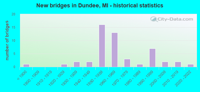
- New bridges - historical statistics
- 1Before 1900
- 11920-1929
- 21930-1939
- 21940-1949
- 161950-1959
- 131960-1969
- 31970-1979
- 11980-1989
- 71990-1999
- 22000-2009
- 22010-2019
- 12020-2022

- Reconstructed bridges - Historical Statistics
- 11970-1979
- 11980-1989
- 81990-1999
- 12000-2009
- 22010-2019


- Bridge Condition - Deck
- 7.1%Excellent
- 7.1%Very good
- 19.0%Good
- 35.7%Satisfactory
- 23.8%Fair
- 4.8%Poor
- 2.4%Serious

- Bridge Condition - Superstructure
- 7.1%Excellent
- 2.4%Very good
- 19.0%Good
- 26.2%Satisfactory
- 35.7%Fair
- 7.1%Poor
- 2.4%Imminent failure

- Bridge Condition - Substructure
- 2.4%Excellent
- 9.5%Very good
- 19.0%Good
- 45.2%Satisfactory
- 21.4%Fair
- 2.4%Poor

- Bridge Condition - Channel
- 2.6%Very good
- 15.8%Good
- 36.8%Satisfactory
- 26.3%Fair
- 15.8%Poor
- 2.6%Serious

- Bridge Condition - Culverts
- 66.7%Good
- 33.3%Fair
Find on map >> Show street view
Structure Number: 707, Location: 1000 FT S OF TOWNLINE RD (Lat: 43.822464, Lng: -83.986547), Route carried "on" structure: County highway , Year Built: 2021, Status: Open, Structure Length: 1.37m (4.49ft), Average Daily Traffic: 409 (year 2020), Truck Traffic: 5%, Average Future Daily Traffic: 499 (year 2040), Design Load: Greater than HL93, Features Intersected: JOHNSON DRAIN, Facility Carried by Structure: MACKINAW ROAD
Minimum Vertical Clearance: 30.48m (100.00ft), Kilometerpoint: 33.276, Lanes on structure: 2, Owner: County Highway Agency, Approaching Roadway Width: 9.8m (32.2ft), Skew: 2 degrees, Material/Design: Prestressed concrete, Design/Construction: Box Beam or Girders - Single/Spread, Number Of Spans In Main Unit: 1, Length of Maximum Span: 13.3m (43.6ft), Curb-To-Curb Width: 9.8m (32.2ft), Out-to-Out Width: 10.5m (34.4ft)
Condition: Deck: Excellent, Superstructure: Excellent, Substructure: Excellent, Channel: Very good, Operating Rating: 78.1 metric tons, Method Used To Determine Operating Rating: Load and Resistance Factor Rating (LRFR) rating reported by rating factor(RF) method using HL-93 loadings, Inventory Rating: 60.3 metric tons, Method Used To Determine Inventory Rating: Load and Resistance Factor Rating (LRFR) rating reported by rating factor(RF) method using HL-93 loadings, Structural Evaluation: Superior to present desirable criteria, Deck Geometry: Equal to present minimum criteria, Waterway Adequacy: Equal to present minimum criteria, Approach Roadway Alignment: Equal to present desirable criteria, Length Of Structure Improvement: 1.30m (4.27ft), Designated Inspection Frequency: Every 9 months, Inspection Date: August 2021, Bridge Improvement Cost: $225,000, Roadway Improvement Cost: $70,000, Total Project Cost: $325,000, Deck Structure Type: Concrete Cast-file-Place, Wearing Surface/Protective System: Wearing Surface: Monolithic Concrete, Deck Protection: Epoxy Coated Reinforcing
Find on map >> Show street view
Structure Number: 707, Location: IN DUNDEE MONROE ST (Lat: 41.956272, Lng: -83.658481), Route carried "on" structure: State highway 50, Year Built: 1937, Year Reconstructed: 2000, Status: Open, Structure Length: 6.15m (20.18ft), Average Daily Traffic: 9,360 (year 2007), Truck Traffic: 4%, Average Future Daily Traffic: 13,555 (year 2018), Design Load: H 20, Features Intersected: RIVER RAISIN
Minimum Vertical Clearance: 30.48m (100.00ft), Kilometerpoint: 9.578, Lanes on structure: 3, Base Highway Network: Yes (Inventory Route: 122, Subroute: 3), Owner: State Highway Agency, Approaching Roadway Width: 19.5m (64.0ft), Skew: 1 degrees, Material/Design: Prestressed concrete, Design/Construction: Box Beam or Girders - Single/Spread, Number Of Spans In Main Unit: 3, Length of Maximum Span: 24.9m (81.7ft), Curb or Sidewalk Widths: Left: 1.8m (5.9ft), Right: 1.8m (5.9ft), Curb-To-Curb Width: 13.2m (43.3ft), Out-to-Out Width: 18.1m (59.4ft)
Condition: Deck: Satisfactory, Superstructure: Satisfactory, Substructure: Fair, Channel: Good, Operating Rating: 53.1 metric tons, Method Used To Determine Operating Rating: Load Factor (LF) rating reported by rating factor (RF) method using MS18 loading, Inventory Rating: 31.8 metric tons, Method Used To Determine Inventory Rating: Load Factor (LF) rating reported by rating factor (RF) method using MS18 loading, Structural Evaluation: Somewhat better than minimum adequacy, Deck Geometry: Somewhat better than minimum adequacy, Waterway Adequacy: Somewhat better than minimum adequacy, Approach Roadway Alignment: Equal to present desirable criteria, Designated Inspection Frequency: Every 24 months, Inspection Date: August 2021, Deck Structure Type: Concrete Cast-file-Place, Wearing Surface/Protective System: Wearing Surface: Monolithic Concrete
Find on map >> Show street view
Structure Number: 7073, Location: 1.5 MI N OF M-50 (Lat: 41.980469, Lng: -83.678267), Route carried "on" structure: US 23, Year Built: 1961, Year Reconstructed: 2003, Status: Open, Structure Length: 3.75m (12.30ft), Average Daily Traffic: 16,735 (year 2007), Truck Traffic: 17%, Average Future Daily Traffic: 20,019 (year 2018), Design Load: HS 20, Features Intersected: S BR MACON RIVER
Minimum Vertical Clearance: 30.48m (100.00ft), Kilometerpoint: 29.298, Lanes on structure: 2, Base Highway Network: Yes (Inventory Route: 122, Subroute: 5), Owner: State Highway Agency, Approaching Roadway Width: 12.8m (42.0ft), Skew: 12 degrees, Material/Design: Steel, Design/Construction: Stringer/Multi-beam, Number Of Spans In Main Unit: 3, Length of Maximum Span: 12.5m (41.0ft), Curb-To-Curb Width: 13.1m (43.0ft), Out-to-Out Width: 14.3m (46.9ft)
Condition: Deck: Satisfactory, Superstructure: Fair, Substructure: Satisfactory, Channel: Satisfactory, Operating Rating: 97.2 metric tons, Method Used To Determine Operating Rating: Load Factor (LF) rating reported by rating factor (RF) method using MS18 loading, Inventory Rating: 73.9 metric tons, Method Used To Determine Inventory Rating: Load Factor (LF) rating reported by rating factor (RF) method using MS18 loading, Structural Evaluation: Somewhat better than minimum adequacy, Deck Geometry: Superior to present desirable criteria, Waterway Adequacy: Equal to present desirable criteria, Approach Roadway Alignment: Equal to present desirable criteria, Designated Inspection Frequency: Every 24 months, Inspection Date: May 2021, Deck Structure Type: Concrete Cast-file-Place, Wearing Surface/Protective System: Wearing Surface: Monolithic Concrete, Deck Protection: Epoxy Coated Reinforcing
Find on map >> Show street view
Structure Number: 7074, Location: 1.5 MI N OF M-50 (Lat: 41.980378, Lng: -83.678608), Route carried "on" structure: US 23, Year Built: 1961, Year Reconstructed: 2003, Status: Open, Structure Length: 3.75m (12.30ft), Average Daily Traffic: 16,735 (year 2007), Truck Traffic: 17%, Average Future Daily Traffic: 20,019 (year 2018), Design Load: HS 20, Features Intersected: S BR MACON RIVER
Minimum Vertical Clearance: 30.48m (100.00ft), Kilometerpoint: 29.364, Lanes on structure: 2, Base Highway Network: Yes (Inventory Route: 122, Subroute: 4), Owner: State Highway Agency, Approaching Roadway Width: 12.8m (42.0ft), Skew: 12 degrees, Material/Design: Steel, Design/Construction: Stringer/Multi-beam, Number Of Spans In Main Unit: 3, Length of Maximum Span: 12.5m (41.0ft), Curb-To-Curb Width: 13.2m (43.3ft), Out-to-Out Width: 14.3m (46.9ft)
Condition: Deck: Satisfactory, Superstructure: Fair, Substructure: Satisfactory, Channel: Satisfactory, Operating Rating: 97.2 metric tons, Method Used To Determine Operating Rating: Load Factor (LF) rating reported by rating factor (RF) method using MS18 loading, Inventory Rating: 73.9 metric tons, Method Used To Determine Inventory Rating: Load Factor (LF) rating reported by rating factor (RF) method using MS18 loading, Structural Evaluation: Somewhat better than minimum adequacy, Deck Geometry: Superior to present desirable criteria, Waterway Adequacy: Equal to present desirable criteria, Approach Roadway Alignment: Equal to present desirable criteria, Designated Inspection Frequency: Every 24 months, Inspection Date: May 2021, Deck Structure Type: Concrete Cast-file-Place, Wearing Surface/Protective System: Wearing Surface: Monolithic Concrete, Deck Protection: Epoxy Coated Reinforcing
Find on map >> Show street view
Structure Number: 7075, Location: 1.7 MI N OF M-50 (Lat: 41.983106, Lng: -83.678314), Route carried "on" structure: US 23, Year Built: 1961, Year Reconstructed: 2003, Status: Open, Structure Length: 3.53m (11.58ft), Average Daily Traffic: 16,735 (year 2007), Truck Traffic: 17%, Average Future Daily Traffic: 20,019 (year 2018), Design Load: HS 20, Features Intersected: MIDDLE BR MACON RIVER
Minimum Vertical Clearance: 30.48m (100.00ft), Kilometerpoint: 29.590, Lanes on structure: 2, Base Highway Network: Yes (Inventory Route: 122, Subroute: 5), Owner: State Highway Agency, Approaching Roadway Width: 12.8m (42.0ft), Skew: 12 degrees, Material/Design: Steel, Design/Construction: Stringer/Multi-beam, Number Of Spans In Main Unit: 3, Length of Maximum Span: 11.8m (38.7ft), Curb-To-Curb Width: 13.1m (43.0ft), Out-to-Out Width: 14.3m (46.9ft)
Condition: Deck: Good, Superstructure: Satisfactory, Substructure: Satisfactory, Channel: Fair, Inventory Rating: 94.4 metric tons, Method Used To Determine Inventory Rating: Load Factor (LF), Structural Evaluation: Equal to present minimum criteria, Deck Geometry: Superior to present desirable criteria, Waterway Adequacy: Equal to present desirable criteria, Approach Roadway Alignment: Equal to present minimum criteria, Designated Inspection Frequency: Every 24 months, Inspection Date: May 2021, Deck Structure Type: Concrete Cast-file-Place, Wearing Surface/Protective System: Wearing Surface: Latex Concrete, Deck Protection: Epoxy Coated Reinforcing
Find on map >> Show street view
Structure Number: 7076, Location: 1.7 MI N OF M-50 (Lat: 41.983014, Lng: -83.678669), Route carried "on" structure: US 23, Year Built: 1961, Year Reconstructed: 2003, Status: Open, Structure Length: 3.53m (11.58ft), Average Daily Traffic: 16,735 (year 2007), Truck Traffic: 17%, Average Future Daily Traffic: 20,019 (year 2018), Design Load: HS 20, Features Intersected: MIDDLE BR MACON RIVER
Minimum Vertical Clearance: 30.48m (100.00ft), Kilometerpoint: 29.656, Lanes on structure: 2, Base Highway Network: Yes (Inventory Route: 122, Subroute: 4), Owner: State Highway Agency, Approaching Roadway Width: 12.8m (42.0ft), Skew: 12 degrees, Material/Design: Steel, Design/Construction: Stringer/Multi-beam, Number Of Spans In Main Unit: 3, Length of Maximum Span: 11.8m (38.7ft), Curb-To-Curb Width: 13.1m (43.0ft), Out-to-Out Width: 14.3m (46.9ft)
Condition: Deck: Good, Superstructure: Satisfactory, Substructure: Satisfactory, Channel: Fair, Inventory Rating: 94.4 metric tons, Method Used To Determine Inventory Rating: Load Factor (LF), Structural Evaluation: Equal to present minimum criteria, Deck Geometry: Superior to present desirable criteria, Waterway Adequacy: Equal to present desirable criteria, Approach Roadway Alignment: Equal to present desirable criteria, Designated Inspection Frequency: Every 24 months, Inspection Date: May 2021, Deck Structure Type: Concrete Cast-file-Place, Wearing Surface/Protective System: Wearing Surface: Monolithic Concrete, Deck Protection: Epoxy Coated Reinforcing
Find on map >> Show street view
Structure Number: 7077, Location: 3.5 MI N OF M-50 (Lat: 42.015083, Lng: -83.678292), Route carried "on" structure: US 23, Year Built: 1961, Status: Open, Structure Length: 1.52m (4.99ft), Average Daily Traffic: 16,735 (year 2007), Truck Traffic: 17%, Average Future Daily Traffic: 20,019 (year 2018), Design Load: HS 20, Features Intersected: BEAR CREEK
Minimum Vertical Clearance: 30.48m (100.00ft), Kilometerpoint: 33.144, Lanes on structure: 2, Base Highway Network: Yes (Inventory Route: 122, Subroute: 5), Owner: State Highway Agency, Approaching Roadway Width: 12.8m (42.0ft), Skew: 12 degrees, Material/Design: Steel, Design/Construction: Stringer/Multi-beam, Number Of Spans In Main Unit: 1, Length of Maximum Span: 15.2m (49.9ft), Curb-To-Curb Width: 13.1m (43.0ft), Out-to-Out Width: 14.3m (46.9ft)
Condition: Deck: Satisfactory, Superstructure: Fair, Substructure: Satisfactory, Channel: Satisfactory, Operating Rating: 60.3 metric tons, Method Used To Determine Operating Rating: Load Factor (LF) rating reported by rating factor (RF) method using MS18 loading, Inventory Rating: 36.0 metric tons, Method Used To Determine Inventory Rating: Load Factor (LF) rating reported by rating factor (RF) method using MS18 loading, Structural Evaluation: Somewhat better than minimum adequacy, Deck Geometry: Superior to present desirable criteria, Waterway Adequacy: Equal to present desirable criteria, Approach Roadway Alignment: Equal to present desirable criteria, Designated Inspection Frequency: Every 24 months, Inspection Date: May 2021, Deck Structure Type: Concrete Cast-file-Place, Wearing Surface/Protective System: Wearing Surface: Epoxy Overlay
Find on map >> Show street view
Structure Number: 7078, Location: 3.8 MI N OF M-50 (Lat: 42.015197, Lng: -83.678647), Route carried "on" structure: US 23, Year Built: 1961, Status: Open, Structure Length: 1.52m (4.99ft), Average Daily Traffic: 16,735 (year 2007), Truck Traffic: 17%, Average Future Daily Traffic: 20,019 (year 2018), Design Load: HS 20, Features Intersected: BEAR CREEK
Minimum Vertical Clearance: 30.48m (100.00ft), Kilometerpoint: 33.233, Lanes on structure: 2, Base Highway Network: Yes (Inventory Route: 122, Subroute: 4), Owner: State Highway Agency, Approaching Roadway Width: 12.8m (42.0ft), Skew: 12 degrees, Material/Design: Steel, Design/Construction: Stringer/Multi-beam, Number Of Spans In Main Unit: 1, Length of Maximum Span: 15.2m (49.9ft), Curb-To-Curb Width: 13.1m (43.0ft), Out-to-Out Width: 14.3m (46.9ft)
Condition: Deck: Satisfactory, Superstructure: Fair, Substructure: Satisfactory, Channel: Satisfactory, Operating Rating: 62.2 metric tons, Method Used To Determine Operating Rating: Load Factor (LF) rating reported by rating factor (RF) method using MS18 loading, Inventory Rating: 37.3 metric tons, Method Used To Determine Inventory Rating: Load Factor (LF) rating reported by rating factor (RF) method using MS18 loading, Structural Evaluation: Somewhat better than minimum adequacy, Deck Geometry: Superior to present desirable criteria, Waterway Adequacy: Equal to present desirable criteria, Approach Roadway Alignment: Equal to present desirable criteria, Designated Inspection Frequency: Every 24 months, Inspection Date: May 2021, Deck Structure Type: Concrete Cast-file-Place, Wearing Surface/Protective System: Wearing Surface: Epoxy Overlay
Find on map >> Show street view
Structure Number: 7079, Location: 4.7 MI N OF M-50 (Lat: 42.025508, Lng: -83.678636), Route carried "on" structure: US 23, Year Built: 1961, Status: Open, Structure Length: 1.52m (4.99ft), Average Daily Traffic: 16,735 (year 2007), Truck Traffic: 17%, Average Future Daily Traffic: 20,019 (year 2018), Design Load: HS 20, Features Intersected: N BR MACON RIVER
Minimum Vertical Clearance: 30.48m (100.00ft), Kilometerpoint: 34.301, Lanes on structure: 2, Base Highway Network: Yes (Inventory Route: 122, Subroute: 5), Owner: State Highway Agency, Approaching Roadway Width: 12.8m (42.0ft), Skew: 12 degrees, Material/Design: Steel, Design/Construction: Stringer/Multi-beam, Number Of Spans In Main Unit: 1, Length of Maximum Span: 15.2m (49.9ft), Curb-To-Curb Width: 13.1m (43.0ft), Out-to-Out Width: 14.3m (46.9ft)
Condition: Deck: Good, Superstructure: Satisfactory, Substructure: Fair, Channel: Fair, Operating Rating: 60.3 metric tons, Method Used To Determine Operating Rating: Load Factor (LF) rating reported by rating factor (RF) method using MS18 loading, Inventory Rating: 36.0 metric tons, Method Used To Determine Inventory Rating: Load Factor (LF) rating reported by rating factor (RF) method using MS18 loading, Structural Evaluation: Somewhat better than minimum adequacy, Deck Geometry: Superior to present desirable criteria, Waterway Adequacy: Equal to present desirable criteria, Approach Roadway Alignment: Equal to present desirable criteria, Designated Inspection Frequency: Every 24 months, Inspection Date: May 2021, Deck Structure Type: Concrete Cast-file-Place, Wearing Surface/Protective System: Wearing Surface: Epoxy Overlay
Find on map >> Show street view
Structure Number: 708, Location: 4.7 MI N OF M-50 (Lat: 42.025631, Lng: -83.679000), Route carried "on" structure: US 23, Year Built: 1961, Status: Open, Structure Length: 1.52m (4.99ft), Average Daily Traffic: 16,735 (year 2007), Truck Traffic: 17%, Average Future Daily Traffic: 20,019 (year 2018), Design Load: HS 20, Features Intersected: N BR MACON RIVER
Minimum Vertical Clearance: 30.48m (100.00ft), Kilometerpoint: 34.391, Lanes on structure: 2, Base Highway Network: Yes (Inventory Route: 122, Subroute: 4), Owner: State Highway Agency, Approaching Roadway Width: 12.8m (42.0ft), Skew: 12 degrees, Material/Design: Steel, Design/Construction: Stringer/Multi-beam, Number Of Spans In Main Unit: 1, Length of Maximum Span: 15.2m (49.9ft), Curb-To-Curb Width: 13.1m (43.0ft), Out-to-Out Width: 14.3m (46.9ft)
Condition: Deck: Satisfactory, Superstructure: Satisfactory, Substructure: Satisfactory, Channel: Fair, Operating Rating: 87.8 metric tons, Method Used To Determine Operating Rating: Load Factor (LF) rating reported by rating factor (RF) method using MS18 loading, Inventory Rating: 52.5 metric tons, Method Used To Determine Inventory Rating: Load Factor (LF) rating reported by rating factor (RF) method using MS18 loading, Structural Evaluation: Equal to present minimum criteria, Deck Geometry: Superior to present desirable criteria, Waterway Adequacy: Equal to present desirable criteria, Approach Roadway Alignment: Equal to present desirable criteria, Designated Inspection Frequency: Every 24 months, Inspection Date: May 2021, Deck Structure Type: Concrete Cast-file-Place, Wearing Surface/Protective System: Wearing Surface: Epoxy Overlay
Find on map >> Show street view
Structure Number: 7083, Location: 3.7 MI N OF M-50 (Lat: 42.011561, Lng: -83.678167), Route carried "on" structure: County highway , Year Built: 1961, Status: Closed, Structure Length: 6.36m (20.87ft), Average Daily Traffic: 290 (year 1974), Truck Traffic: 3%, Average Future Daily Traffic: 290 (year 1977), Design Load: H 15, Features Intersected: US-23, Facility Carried by Structure: MILWAUKEE RD
Minimum Vertical Clearance: 30.48m (100.00ft), Kilometerpoint: 7.764, Lanes on structure: 2, Lanes under structure: 4, Owner: State Highway Agency, Approaching Roadway Width: 10.3m (33.8ft), Material/Design: Steel, Design/Construction: Stringer/Multi-beam, Number Of Spans In Main Unit: 4, Length of Maximum Span: 21.6m (70.9ft), Curb-To-Curb Width: 9.0m (29.5ft), Out-to-Out Width: 9.9m (32.5ft)
Condition: Deck: Fair, Superstructure: Fair, Substructure: Satisfactory, Operating Rating: 53.1 metric tons, Method Used To Determine Operating Rating: Load Factor (LF) rating reported by rating factor (RF) method using MS18 loading, Inventory Rating: 28.5 metric tons, Method Used To Determine Inventory Rating: Load Factor (LF) rating reported by rating factor (RF) method using MS18 loading, Structural Evaluation: Somewhat better than minimum adequacy, Deck Geometry: Equal to present minimum criteria, Underclear: Somewhat better than minimum adequacy, Approach Roadway Alignment: Equal to present desirable criteria, Designated Inspection Frequency: Every 24 months, Inspection Date: May 2021, Deck Structure Type: Concrete Cast-file-Place, Wearing Surface/Protective System: Wearing Surface: Latex Concrete
Find on map >> Show street view
Structure Number: 7093, Location: 1.0 MI S OF M-50 (Lat: 41.945622, Lng: -83.665719), Route carried "on" structure: US 23, Year Built: 1958, Year Reconstructed: 2003, Status: Open, Structure Length: 7.62m (25.00ft), Average Daily Traffic: 17,262 (year 2007), Truck Traffic: 17%, Average Future Daily Traffic: 19,397 (year 2018), Design Load: HS 20, Features Intersected: RIVER RAISIN
Minimum Vertical Clearance: 30.48m (100.00ft), Kilometerpoint: 25.276, Lanes on structure: 2, Base Highway Network: Yes (Inventory Route: 122, Subroute: 5), Owner: State Highway Agency, Approaching Roadway Width: 12.2m (40.0ft), Skew: 12 degrees, Material/Design: Steel, Design/Construction: Stringer/Multi-beam, Number Of Spans In Main Unit: 3, Length of Maximum Span: 30.4m (99.7ft), Curb-To-Curb Width: 10.1m (33.1ft), Out-to-Out Width: 11.1m (36.4ft)
Condition: Deck: Satisfactory, Superstructure: Fair, Substructure: Satisfactory, Channel: Satisfactory, Operating Rating: 97.2 metric tons, Method Used To Determine Operating Rating: Load Factor (LF) rating reported by rating factor (RF) method using MS18 loading, Inventory Rating: 75.5 metric tons, Method Used To Determine Inventory Rating: Load Factor (LF) rating reported by rating factor (RF) method using MS18 loading, Structural Evaluation: Somewhat better than minimum adequacy, Deck Geometry: Somewhat better than minimum adequacy, Waterway Adequacy: Equal to present minimum criteria, Approach Roadway Alignment: Equal to present desirable criteria, Designated Inspection Frequency: Every 24 months, Inspection Date: May 2021, Deck Structure Type: Concrete Cast-file-Place, Wearing Surface/Protective System: Wearing Surface: Monolithic Concrete, Deck Protection: Epoxy Coated Reinforcing
Find on map >> Show street view
Structure Number: 7101, Location: 3.0 MI S OF DUNDEE (Lat: 41.914314, Lng: -83.661897), Route carried "on" structure: US 23, Year Built: 1958, Status: Open, Structure Length: 5.67m (18.60ft), Average Daily Traffic: 16,733 (year 2007), Truck Traffic: 16%, Average Future Daily Traffic: 19,701 (year 2018), Design Load: HS 20, Features Intersected: INDIANA & OHIO RR
Minimum Vertical Clearance: 30.48m (100.00ft), Kilometerpoint: 21.690, Lanes on structure: 2, Base Highway Network: Yes (Inventory Route: 122, Subroute: 5), Owner: State Highway Agency, Approaching Roadway Width: 12.2m (40.0ft), Skew: 14 degrees, Material/Design: Prestressed concrete, Design/Construction: Box Beam or Girders - Multiple, Number Of Spans In Main Unit: 3, Length of Maximum Span: 18.9m (62.0ft), Curb-To-Curb Width: 13.1m (43.0ft), Out-to-Out Width: 14.9m (48.9ft)
Condition: Deck: Fair, Superstructure: Poor, Substructure: Fair, Operating Rating: 65.4 metric tons, Method Used To Determine Operating Rating: Load Factor (LF) rating reported by rating factor (RF) method using MS18 loading, Inventory Rating: 34.3 metric tons, Method Used To Determine Inventory Rating: Load Factor (LF) rating reported by rating factor (RF) method using MS18 loading, Structural Evaluation: Meets minimum limits, Deck Geometry: Superior to present desirable criteria, Underclear: Somewhat better than minimum adequacy, Approach Roadway Alignment: Equal to present desirable criteria, Designated Inspection Frequency: Every 12 months, Inspection Date: July 2021, Deck Structure Type: Concrete Cast-file-Place, Wearing Surface/Protective System: Wearing Surface: Epoxy Overlay
Find on map >> Show street view
Structure Number: 7102, Location: 3.0 MI S OF DUNDEE (Lat: 41.914139, Lng: -83.662156), Route carried "on" structure: US 23, Year Built: 1958, Status: Open, Structure Length: 5.67m (18.60ft), Average Daily Traffic: 16,733 (year 2007), Truck Traffic: 16%, Average Future Daily Traffic: 19,701 (year 2018), Design Load: HS 20, Features Intersected: INDIANA & OHIO RR
Minimum Vertical Clearance: 30.48m (100.00ft), Kilometerpoint: 21.741, Lanes on structure: 2, Base Highway Network: Yes (Inventory Route: 122, Subroute: 4), Owner: State Highway Agency, Approaching Roadway Width: 12.2m (40.0ft), Skew: 14 degrees, Material/Design: Prestressed concrete, Design/Construction: Box Beam or Girders - Multiple, Number Of Spans In Main Unit: 3, Length of Maximum Span: 18.9m (62.0ft), Curb-To-Curb Width: 13.1m (43.0ft), Out-to-Out Width: 14.8m (48.6ft)
Condition: Deck: Fair, Superstructure: Fair, Substructure: Fair, Operating Rating: 95.3 metric tons, Method Used To Determine Operating Rating: Load Factor (LF) rating reported by rating factor (RF) method using MS18 loading, Inventory Rating: 49.6 metric tons, Method Used To Determine Inventory Rating: Load Factor (LF) rating reported by rating factor (RF) method using MS18 loading, Structural Evaluation: Somewhat better than minimum adequacy, Deck Geometry: Superior to present desirable criteria, Approach Roadway Alignment: Equal to present desirable criteria, Designated Inspection Frequency: Every 24 months, Inspection Date: July 2021, Deck Structure Type: Concrete Cast-file-Place, Wearing Surface/Protective System: Wearing Surface: Epoxy Overlay
Find on map >> Show street view
Structure Number: 7109, Location: 3.5 MI S OF M-50 (Lat: 41.909942, Lng: -83.661786), Route carried "on" structure: County highway 5850, Year Built: 1958, Status: Open, Structure Length: 6.15m (20.18ft), Average Daily Traffic: 2,070 (year 1974), Truck Traffic: 3%, Average Future Daily Traffic: 2,070 (year 1977), Design Load: H 15, Features Intersected: US-23, Facility Carried by Structure: IDA WEST RD
Minimum Vertical Clearance: 30.48m (100.00ft), Kilometerpoint: 2.815, Lanes on structure: 2, Lanes under structure: 4, Base Highway Network: Yes (Inventory Route: 122, Subroute: 6), Owner: State Highway Agency, Approaching Roadway Width: 10.3m (33.8ft), Material/Design: Concrete continuous, Design/Construction: Tee Beam, Number Of Spans In Main Unit: 4, Length of Maximum Span: 17.9m (58.7ft), Curb-To-Curb Width: 9.7m (31.8ft), Out-to-Out Width: 10.1m (33.1ft)
Condition: Deck: Poor, Superstructure: Poor, Substructure: Satisfactory, Operating Rating: 50.2 metric tons, Method Used To Determine Operating Rating: Load Factor (LF) rating reported by rating factor (RF) method using MS18 loading, Inventory Rating: 30.1 metric tons, Method Used To Determine Inventory Rating: Load Factor (LF) rating reported by rating factor (RF) method using MS18 loading, Structural Evaluation: Meets minimum limits, Deck Geometry: Meets minimum limits, Underclear: Somewhat better than minimum adequacy, Approach Roadway Alignment: Equal to present desirable criteria, Designated Inspection Frequency: Every 12 months, Inspection Date: April 2021, Deck Structure Type: Concrete Cast-file-Place, Wearing Surface/Protective System: Wearing Surface: Latex Concrete
Find on map >> Show street view
Structure Number: 711, Location: 2.2 MI S OF M-50 (Lat: 41.930053, Lng: -83.662264), Route carried "on" structure: County highway , Year Built: 1959, Status: Open, Structure Length: 8.23m (27.00ft), Average Daily Traffic: 980 (year 1974), Average Future Daily Traffic: 980 (year 1977), Design Load: H 15, Features Intersected: US-23, Facility Carried by Structure: DIXON RD
Minimum Vertical Clearance: 30.48m (100.00ft), Kilometerpoint: 5.449, Lanes on structure: 2, Lanes under structure: 4, Owner: State Highway Agency, Approaching Roadway Width: 10.3m (33.8ft), Skew: 4 degrees, Material/Design: Concrete continuous, Design/Construction: Tee Beam, Number Of Spans In Main Unit: 4, Length of Maximum Span: 24.0m (78.7ft), Curb-To-Curb Width: 9.7m (31.8ft), Out-to-Out Width: 10.1m (33.1ft)
Condition: Deck: Fair, Superstructure: Fair, Substructure: Satisfactory, Operating Rating: 51.2 metric tons, Method Used To Determine Operating Rating: Load Factor (LF) rating reported by rating factor (RF) method using MS18 loading, Inventory Rating: 31.1 metric tons, Method Used To Determine Inventory Rating: Load Factor (LF) rating reported by rating factor (RF) method using MS18 loading, Structural Evaluation: Somewhat better than minimum adequacy, Deck Geometry: Equal to present minimum criteria, Underclear: Somewhat better than minimum adequacy, Approach Roadway Alignment: Equal to present desirable criteria, Designated Inspection Frequency: Every 24 months, Inspection Date: April 2021, Deck Structure Type: Concrete Cast-file-Place, Wearing Surface/Protective System: Wearing Surface: Latex Concrete
Find on map >> Show street view
Structure Number: 7111, Location: 0.7 MI S OF M-50 (Lat: 41.950242, Lng: -83.668600), Route carried "on" structure: City street , Year Built: 1959, Status: Open, Structure Length: 5.21m (17.09ft), Average Daily Traffic: 250 (year 1974), Truck Traffic: 3%, Average Future Daily Traffic: 250 (year 1977), Design Load: H 15, Features Intersected: US-23, Facility Carried by Structure: BREWER RD
Minimum Vertical Clearance: 30.48m (100.00ft), Kilometerpoint: 8.609, Lanes on structure: 2, Lanes under structure: 4, Owner: State Highway Agency, Approaching Roadway Width: 10.3m (33.8ft), Material/Design: Concrete continuous, Design/Construction: Tee Beam, Number Of Spans In Main Unit: 4, Length of Maximum Span: 14.9m (48.9ft), Curb-To-Curb Width: 9.7m (31.8ft), Out-to-Out Width: 10.1m (33.1ft)
Condition: Deck: Fair, Superstructure: Fair, Substructure: Satisfactory, Operating Rating: 49.6 metric tons, Method Used To Determine Operating Rating: Load Factor (LF) rating reported by rating factor (RF) method using MS18 loading, Inventory Rating: 26.6 metric tons, Method Used To Determine Inventory Rating: Load Factor (LF) rating reported by rating factor (RF) method using MS18 loading, Structural Evaluation: Somewhat better than minimum adequacy, Deck Geometry: Equal to present minimum criteria, Underclear: Somewhat better than minimum adequacy, Approach Roadway Alignment: Equal to present desirable criteria, Designated Inspection Frequency: Every 24 months, Inspection Date: April 2021, Deck Structure Type: Concrete Cast-file-Place, Wearing Surface/Protective System: Wearing Surface: Latex Concrete
Find on map >> Show street view
Structure Number: 7112, Location: IN DUNDEE (Lat: 41.959356, Lng: -83.672381), Route carried "on" structure: US 23, Year Built: 1958, Status: Open, Structure Length: 6.00m (19.69ft), Average Daily Traffic: 34,524 (year 2007), Truck Traffic: 17%, Average Future Daily Traffic: 40,038 (year 2018), Design Load: HS 20, Features Intersected: M-50
Minimum Vertical Clearance: 30.48m (100.00ft), Kilometerpoint: 26.853, Lanes on structure: 4, Lanes under structure: 5, Base Highway Network: Yes (Inventory Route: 122, Subroute: 5), Owner: State Highway Agency, Approaching Roadway Width: 12.2m (40.0ft), Skew: 31 degrees, Material/Design: Concrete continuous, Design/Construction: Tee Beam, Number Of Spans In Main Unit: 3, Length of Maximum Span: 24.7m (81.0ft), Curb-To-Curb Width: 29.0m (95.1ft), Out-to-Out Width: 30.3m (99.4ft)
Condition: Deck: Fair, Superstructure: Fair, Substructure: Fair, Operating Rating: 62.5 metric tons, Method Used To Determine Operating Rating: Load Factor (LF) rating reported by rating factor (RF) method using MS18 loading, Inventory Rating: 37.6 metric tons, Method Used To Determine Inventory Rating: Load Factor (LF) rating reported by rating factor (RF) method using MS18 loading, Structural Evaluation: Somewhat better than minimum adequacy, Deck Geometry: Superior to present desirable criteria, Underclear: Meets minimum limits, Approach Roadway Alignment: Equal to present desirable criteria, Designated Inspection Frequency: Every 24 months, Inspection Date: April 2021, Deck Structure Type: Concrete Cast-file-Place, Wearing Surface/Protective System: Wearing Surface: Latex Concrete
Find on map >> Show street view
Structure Number: 7113, Location: 2.5 MI W OF DUNDEE (Lat: 41.965411, Lng: -83.707050), Route carried "on" structure: State highway 50, Year Built: 1953, Status: Open, Structure Length: 1.67m (5.48ft), Average Daily Traffic: 6,646 (year 2007), Truck Traffic: 6%, Average Future Daily Traffic: 12,805 (year 2018), Design Load: HS 20, Features Intersected: S BR MACON RIVER
Minimum Vertical Clearance: 30.48m (100.00ft), Kilometerpoint: 5.446, Lanes on structure: 2, Base Highway Network: Yes (Inventory Route: 122, Subroute: 3), Owner: State Highway Agency, Approaching Roadway Width: 14.6m (47.9ft), Skew: 1 degrees, Material/Design: Steel, Design/Construction: Stringer/Multi-beam, Number Of Spans In Main Unit: 1, Length of Maximum Span: 16.7m (54.8ft), Curb or Sidewalk Widths: Left: 0.4m (1.3ft), Right: 0.4m (1.3ft), Curb-To-Curb Width: 11.6m (38.1ft), Out-to-Out Width: 13.2m (43.3ft)
Condition: Deck: Satisfactory, Superstructure: Fair, Substructure: Satisfactory, Channel: Fair, Operating Rating: 72.6 metric tons, Method Used To Determine Operating Rating: Load Factor (LF) rating reported by rating factor (RF) method using MS18 loading, Inventory Rating: 43.4 metric tons, Method Used To Determine Inventory Rating: Load Factor (LF) rating reported by rating factor (RF) method using MS18 loading, Structural Evaluation: Somewhat better than minimum adequacy, Deck Geometry: Somewhat better than minimum adequacy, Waterway Adequacy: Equal to present desirable criteria, Approach Roadway Alignment: Equal to present desirable criteria, Length Of Structure Improvement: 1.68m (5.51ft), Designated Inspection Frequency: Every 24 months, Inspection Date: August 2021, Bridge Improvement Cost: $30,000, Roadway Improvement Cost: $4,000, Total Project Cost: $50,000, Deck Structure Type: Concrete Cast-file-Place, Wearing Surface/Protective System: Wearing Surface: Bituminous
Find on map >> Show street view
Structure Number: 7232, Location: .2 MI SO OF M 50 (Lat: 41.961250, Lng: -83.711844), Route carried "on" structure: County highway 5815, Year Built: 1958, Year Reconstructed: 2019, Status: Open, Structure Length: 1.16m (3.81ft), Average Daily Traffic: 500 (year 2016), Truck Traffic: 17%, Average Future Daily Traffic: 575 (year 2036), Design Load: HL 93, Features Intersected: SO BR MACON DR, Facility Carried by Structure: PETERSBURG RD
Minimum Vertical Clearance: 30.48m (100.00ft), Kilometerpoint: 6.404, Lanes on structure: 2, Owner: County Highway Agency, Approaching Roadway Width: 6.7m (22.0ft), Material/Design: Steel, Design/Construction: Box Beam or Girders - Single/Spread, Number Of Spans In Main Unit: 1, Length of Maximum Span: 10.3m (33.8ft), Curb-To-Curb Width: 8.5m (27.9ft), Out-to-Out Width: 9.5m (31.2ft)
Condition: Deck: Excellent, Superstructure: Excellent, Substructure: Satisfactory, Channel: Good, Operating Rating: 82.9 metric tons, Method Used To Determine Operating Rating: Load and Resistance Factor Rating (LRFR) rating reported by rating factor(RF) method using HL-93 loadings, Inventory Rating: 63.8 metric tons, Method Used To Determine Inventory Rating: Load and Resistance Factor Rating (LRFR) rating reported by rating factor(RF) method using HL-93 loadings, Structural Evaluation: Equal to present minimum criteria, Deck Geometry: Somewhat better than minimum adequacy, Waterway Adequacy: Equal to present minimum criteria, Approach Roadway Alignment: Equal to present minimum criteria, Designated Inspection Frequency: Every 24 months, Inspection Date: November 2021, Deck Structure Type: Concrete Precast Panels, Wearing Surface/Protective System: Wearing Surface: Monolithic Concrete, Membrane: Epoxy, Deck Protection: Epoxy Coated Reinforcing
Find on map >> Show street view
Structure Number: 7233, Location: 1.25 MI S OF M-50 (Lat: 41.947167, Lng: -83.711547), Route carried "on" structure: County highway 5815, Year Built: 1956, Year Reconstructed: 2019, Status: Open, Structure Length: 1.22m (4.00ft), Average Daily Traffic: 500 (year 2016), Truck Traffic: 17%, Average Future Daily Traffic: 575 (year 2036), Design Load: HL 93, Features Intersected: SWAMP RAISIN DRAIN, Facility Carried by Structure: PETERSBURG RD
Minimum Vertical Clearance: 30.48m (100.00ft), Kilometerpoint: 4.839, Lanes on structure: 2, Owner: County Highway Agency, Approaching Roadway Width: 6.7m (22.0ft), Skew: 3 degrees, Material/Design: Steel, Design/Construction: Box Beam or Girders - Single/Spread, Number Of Spans In Main Unit: 1, Length of Maximum Span: 10.6m (34.8ft), Curb-To-Curb Width: 8.5m (27.9ft), Out-to-Out Width: 9.5m (31.2ft)
Condition: Deck: Excellent, Superstructure: Excellent, Substructure: Satisfactory, Channel: Good, Operating Rating: 77.1 metric tons, Method Used To Determine Operating Rating: Load and Resistance Factor Rating (LRFR) rating reported by rating factor(RF) method using HL-93 loadings, Inventory Rating: 59.6 metric tons, Method Used To Determine Inventory Rating: Load and Resistance Factor Rating (LRFR) rating reported by rating factor(RF) method using HL-93 loadings, Structural Evaluation: Equal to present minimum criteria, Deck Geometry: Somewhat better than minimum adequacy, Waterway Adequacy: Equal to present minimum criteria, Approach Roadway Alignment: Equal to present minimum criteria, Designated Inspection Frequency: Every 24 months, Inspection Date: November 2021, Deck Structure Type: Concrete Precast Panels, Wearing Surface/Protective System: Wearing Surface: Monolithic Concrete, Membrane: Epoxy, Deck Protection: Epoxy Coated Reinforcing
Find on map >> Show street view
Structure Number: 7234, Location: 1.75 MI S OF M-50 (Lat: 41.942281, Lng: -83.711394), Route carried "on" structure: County highway 5815, Year Built: 1978, Status: Open, Structure Length: 0.91m (2.99ft), Average Daily Traffic: 689 (year 2011), Truck Traffic: 3%, Average Future Daily Traffic: 870 (year 2031), Design Load: HS 20, Features Intersected: LITTLE RAISIN RIVER, Facility Carried by Structure: PETERSBURG ROAD
Minimum Vertical Clearance: 30.48m (100.00ft), Kilometerpoint: 4.297, Lanes on structure: 2, Owner: County Highway Agency, Approaching Roadway Width: 8.2m (26.9ft), Material/Design: Prestressed concrete, Design/Construction: Box Beam or Girders - Multiple, Number Of Spans In Main Unit: 1, Length of Maximum Span: 8.8m (28.9ft), Curb-To-Curb Width: 10.1m (33.1ft), Out-to-Out Width: 10.2m (33.5ft)
Condition: Deck: Satisfactory, Superstructure: Satisfactory, Substructure: Satisfactory, Channel: Satisfactory, Operating Rating: 57.7 metric tons, Method Used To Determine Operating Rating: Load Factor (LF) rating reported by rating factor (RF) method using MS18 loading, Inventory Rating: 34.7 metric tons, Method Used To Determine Inventory Rating: Load Factor (LF) rating reported by rating factor (RF) method using MS18 loading, Structural Evaluation: Equal to present minimum criteria, Deck Geometry: Equal to present minimum criteria, Waterway Adequacy: Equal to present desirable criteria, Approach Roadway Alignment: Equal to present minimum criteria, Designated Inspection Frequency: Every 24 months, Inspection Date: October 2020, Deck Structure Type: Concrete Precast Panels, Wearing Surface/Protective System: Wearing Surface: Bituminous, Membrane: Other
Find on map >> Show street view
Structure Number: 7245, Location: 2.75 MI E OF COUNTY LINE (Lat: 41.945356, Lng: -83.718947), Route carried "on" structure: County highway , Year Built: 2009, Status: Open, Structure Length: 2.10m (6.89ft), Average Daily Traffic: 260 (year 2015), Truck Traffic: 2%, Average Future Daily Traffic: 299 (year 2035), Design Load: HS 20+Mod, Features Intersected: SWAMP RAISIN CREEK, Facility Carried by Structure: BREWER RD
Minimum Vertical Clearance: 30.48m (100.00ft), Kilometerpoint: 4.276, Lanes on structure: 2, Owner: County Highway Agency, Approaching Roadway Width: 9.1m (29.9ft), Skew: 3 degrees, Material/Design: Prestressed concrete, Design/Construction: Box Beam or Girders - Multiple, Number Of Spans In Main Unit: 1, Length of Maximum Span: 20.5m (67.3ft), Curb-To-Curb Width: 9.1m (29.9ft), Out-to-Out Width: 9.5m (31.2ft)
Condition: Deck: Good, Superstructure: Good, Substructure: Very good, Channel: Satisfactory, Operating Rating: 94.8 metric tons, Method Used To Determine Operating Rating: Load and Resistance Factor (LRFR), Inventory Rating: 56.8 metric tons, Method Used To Determine Inventory Rating: Load and Resistance Factor (LRFR), Structural Evaluation: Better than present minimum criteria, Deck Geometry: Equal to present minimum criteria, Waterway Adequacy: Equal to present desirable criteria, Approach Roadway Alignment: Equal to present minimum criteria, Designated Inspection Frequency: Every 24 months, Inspection Date: May 2021, Deck Structure Type: Concrete Cast-file-Place, Wearing Surface/Protective System: Wearing Surface: Monolithic Concrete, Deck Protection: Epoxy Coated Reinforcing
Find on map >> Show street view
Structure Number: 7246, Location: 3.55 MI E OF COUNTY LINE (Lat: 41.945700, Lng: -83.704519), Route carried "on" structure: County highway , Year Built: 1967, Status: Open, Structure Length: 1.33m (4.36ft), Average Daily Traffic: 670 (year 2015), Truck Traffic: 1%, Average Future Daily Traffic: 771 (year 2035), Features Intersected: SWAMP RAISIN DRAIN, Facility Carried by Structure: BREWER RD
Minimum Vertical Clearance: 30.48m (100.00ft), Kilometerpoint: 5.472, Lanes on structure: 2, Owner: County Highway Agency, Approaching Roadway Width: 8.8m (28.9ft), Skew: 3 degrees, Material/Design: Steel, Design/Construction: Stringer/Multi-beam, Number Of Spans In Main Unit: 1, Length of Maximum Span: 12.0m (39.4ft), Curb-To-Curb Width: 8.5m (27.9ft), Out-to-Out Width: 8.5m (27.9ft)
Condition: Deck: Poor, Superstructure: Fair, Substructure: Fair, Channel: Fair, Operating Rating: 77.1 metric tons, Method Used To Determine Operating Rating: Load Factor (LF) rating reported by rating factor (RF) method using MS18 loading, Inventory Rating: 46.0 metric tons, Method Used To Determine Inventory Rating: Load Factor (LF) rating reported by rating factor (RF) method using MS18 loading, Structural Evaluation: Somewhat better than minimum adequacy, Deck Geometry: Somewhat better than minimum adequacy, Waterway Adequacy: Better than present minimum criteria, Approach Roadway Alignment: Meets minimum limits, Designated Inspection Frequency: Every 12 months, Inspection Date: May 2021, Deck Structure Type: Concrete Cast-file-Place, Wearing Surface/Protective System: Wearing Surface: Monolithic Concrete
Find on map >> Show street view
Structure Number: 7247, Location: 1.85 MI N OF DUNDEE (Lat: 41.978989, Lng: -83.627492), Route carried "on" structure: County highway 5866, Year Built: 1964, Status: Open, Structure Length: 3.65m (11.98ft), Average Daily Traffic: 1,300 (year 2017), Truck Traffic: 2%, Average Future Daily Traffic: 1,495 (year 2037), Design Load: H 20, Features Intersected: MACON RIVER, Facility Carried by Structure: STOWELL RD
Minimum Vertical Clearance: 30.48m (100.00ft), Kilometerpoint: 5.111, Lanes on structure: 2, Owner: County Highway Agency, Approaching Roadway Width: 8.5m (27.9ft), Skew: 1 degrees, Material/Design: Prestressed concrete, Design/Construction: Box Beam or Girders - Multiple, Number Of Spans In Main Unit: 3, Length of Maximum Span: 11.8m (38.7ft), Curb or Sidewalk Widths: Left: 0.4m (1.3ft), Right: 0.4m (1.3ft), Curb-To-Curb Width: 8.5m (27.9ft), Out-to-Out Width: 10.1m (33.1ft)
Condition: Deck: Fair, Superstructure: Fair, Substructure: Fair, Channel: Poor, Operating Rating: 50.9 metric tons, Method Used To Determine Operating Rating: Load Factor (LF) rating reported by rating factor (RF) method using MS18 loading, Inventory Rating: 30.5 metric tons, Method Used To Determine Inventory Rating: Load Factor (LF) rating reported by rating factor (RF) method using MS18 loading, Structural Evaluation: Somewhat better than minimum adequacy, Deck Geometry: Somewhat better than minimum adequacy, Waterway Adequacy: Equal to present desirable criteria, Approach Roadway Alignment: High priority of corrective action, Length Of Structure Improvement: 3.66m (12.01ft), Designated Inspection Frequency: Every 24 months, Inspection Date: October 2020, Bridge Improvement Cost: $60,000, Total Project Cost: $70,000, Deck Structure Type: Concrete Precast Panels, Wearing Surface/Protective System: Wearing Surface: Integral Concrete
Find on map >> Show street view
Structure Number: 7249, Location: 1.25 MI N OF M 50 (Lat: 41.986667, Lng: -83.731919), Route carried "on" structure: County highway 5809, Year Built: 2011, Status: Open, Structure Length: 1.89m (6.20ft), Average Daily Traffic: 430 (year 2015), Truck Traffic: 14%, Average Future Daily Traffic: 495 (year 2035), Design Load: HL 93, Features Intersected: N DR MID BR MACON R, Facility Carried by Structure: DENNISON RD
Minimum Vertical Clearance: 30.48m (100.00ft), Kilometerpoint: 8.662, Lanes on structure: 2, Owner: County Highway Agency, Approaching Roadway Width: 9.1m (29.9ft), Material/Design: Prestressed concrete, Design/Construction: Box Beam or Girders - Multiple, Number Of Spans In Main Unit: 1, Length of Maximum Span: 18.5m (60.7ft), Curb-To-Curb Width: 9.1m (29.9ft), Out-to-Out Width: 9.5m (31.2ft)
Condition: Deck: Good, Superstructure: Good, Substructure: Very good, Channel: Good, Operating Rating: 97.2 metric tons, Method Used To Determine Operating Rating: Load and Resistance Factor Rating (LRFR) rating reported by rating factor(RF) method using HL-93 loadings, Inventory Rating: 70.6 metric tons, Method Used To Determine Inventory Rating: Load and Resistance Factor Rating (LRFR) rating reported by rating factor(RF) method using HL-93 loadings, Structural Evaluation: Better than present minimum criteria, Deck Geometry: Equal to present minimum criteria, Waterway Adequacy: Equal to present desirable criteria, Approach Roadway Alignment: Equal to present minimum criteria, Designated Inspection Frequency: Every 24 months, Inspection Date: June 2021, Deck Structure Type: Concrete Cast-file-Place, Wearing Surface/Protective System: Wearing Surface: Monolithic Concrete, Deck Protection: Epoxy Coated Reinforcing
Find on map >> Show street view
Structure Number: 725, Location: .3 MI NO OF M 50 (Lat: 41.974256, Lng: -83.731494), Route carried "on" structure: County highway 5809, Year Built: 2017, Status: Open, Structure Length: 1.07m (3.51ft), Average Daily Traffic: 484 (year 2017), Truck Traffic: 8%, Average Future Daily Traffic: 875 (year 2037), Design Load: Greater than HL93, Features Intersected: MIDDLE BRANCH MACON DRAI, Facility Carried by Structure: DENNISON RD
Minimum Vertical Clearance: 30.48m (100.00ft), Kilometerpoint: 7.284, Lanes on structure: 2, Owner: County Highway Agency, Approaching Roadway Width: 9.8m (32.2ft), Material/Design: Concrete, Design/Construction: Culvert, Number Of Spans In Main Unit: 1, Length of Maximum Span: 9.8m (32.2ft), Curb-To-Curb Width: 9.8m (32.2ft), Out-to-Out Width: 11.0m (36.1ft)
Condition: Channel: Satisfactory, Culverts: Good, Operating Rating: 97.2 metric tons, Method Used To Determine Operating Rating: Load and Resistance Factor Rating (LRFR) rating reported by rating factor(RF) method using HL-93 loadings, Inventory Rating: 77.8 metric tons, Method Used To Determine Inventory Rating: Load and Resistance Factor Rating (LRFR) rating reported by rating factor(RF) method using HL-93 loadings, Structural Evaluation: Better than present minimum criteria, Deck Geometry: Equal to present minimum criteria, Waterway Adequacy: Equal to present desirable criteria, Approach Roadway Alignment: Equal to present minimum criteria, Designated Inspection Frequency: Every 24 months, Inspection Date: October 2021, Wearing Surface/Protective System: Wearing Surface: Bituminous
Find on map >> Show street view
Structure Number: 7256, Location: 0.2 MI N OF OSTRANDER RD (Lat: 42.022539, Lng: -83.674222), Route carried "on" structure: County highway 5817, Year Built: 1947, Year Reconstructed: 2003, Status: Open, Structure Length: 1.37m (4.49ft), Average Daily Traffic: 2,378 (year 2017), Truck Traffic: 15%, Average Future Daily Traffic: 2,735 (year 2037), Design Load: HS 20, Features Intersected: NORTH MACON CREEK, Facility Carried by Structure: ANN ARBOR ROAD
Minimum Vertical Clearance: 30.48m (100.00ft), Kilometerpoint: 7.099, Lanes on structure: 2, Owner: County Highway Agency, Approaching Roadway Width: 11.9m (39.0ft), Material/Design: Prestressed concrete, Design/Construction: Box Beam or Girders - Multiple, Number Of Spans In Main Unit: 1, Length of Maximum Span: 13.1m (43.0ft), Curb or Sidewalk Widths: Left: 0.4m (1.3ft), Right: 0.4m (1.3ft), Curb-To-Curb Width: 13.7m (44.9ft), Out-to-Out Width: 14.4m (47.2ft)
Condition: Deck: Very good, Superstructure: Good, Substructure: Good, Channel: Satisfactory, Operating Rating: 87.4 metric tons, Method Used To Determine Operating Rating: Load Factor (LF), Inventory Rating: 32.2 metric tons, Method Used To Determine Inventory Rating: Load Factor (LF), Structural Evaluation: Better than present minimum criteria, Deck Geometry: Superior to present desirable criteria, Waterway Adequacy: Equal to present desirable criteria, Approach Roadway Alignment: Equal to present minimum criteria, Designated Inspection Frequency: Every 24 months, Inspection Date: November 2021, Deck Structure Type: Concrete Cast-file-Place, Wearing Surface/Protective System: Wearing Surface: Monolithic Concrete, Deck Protection: Epoxy Coated Reinforcing
Find on map >> Show street view
Structure Number: 7257, Location: 3.95 MI N OF M 50 (Lat: 42.014086, Lng: -83.673958), Route carried "on" structure: County highway 5817, Year Built: 1947, Year Reconstructed: 2003, Status: Open, Structure Length: 1.07m (3.51ft), Average Daily Traffic: 2,766 (year 2017), Truck Traffic: 15%, Average Future Daily Traffic: 3,181 (year 2037), Design Load: HS 20, Features Intersected: BEAR SWAMP CREEK, Facility Carried by Structure: ANN ARBOR ROAD
Minimum Vertical Clearance: 30.48m (100.00ft), Kilometerpoint: 6.161, Lanes on structure: 2, Owner: County Highway Agency, Approaching Roadway Width: 11.9m (39.0ft), Material/Design: Prestressed concrete, Design/Construction: Box Beam or Girders - Multiple, Number Of Spans In Main Unit: 1, Length of Maximum Span: 10.0m (32.8ft), Curb or Sidewalk Widths: Left: 0.4m (1.3ft), Right: 0.4m (1.3ft), Curb-To-Curb Width: 13.7m (44.9ft), Out-to-Out Width: 14.4m (47.2ft)
Condition: Deck: Very good, Superstructure: Good, Substructure: Fair, Channel: Satisfactory, Operating Rating: 86.3 metric tons, Method Used To Determine Operating Rating: Load Factor (LF), Inventory Rating: 32.0 metric tons, Method Used To Determine Inventory Rating: Load Factor (LF), Structural Evaluation: Somewhat better than minimum adequacy, Deck Geometry: Superior to present desirable criteria, Waterway Adequacy: Equal to present desirable criteria, Approach Roadway Alignment: Equal to present minimum criteria, Designated Inspection Frequency: Every 24 months, Inspection Date: November 2021, Deck Structure Type: Concrete Cast-file-Place, Wearing Surface/Protective System: Wearing Surface: Monolithic Concrete, Deck Protection: Epoxy Coated Reinforcing
Find on map >> Show street view
Structure Number: 728, Location: .35 MI E OF ANN ARBOR RD (Lat: 42.019011, Lng: -83.667256), Route carried "on" structure: County highway 5878, Year Built: 1950, Status: Open, Structure Length: 1.52m (4.99ft), Average Daily Traffic: 926 (year 2017), Truck Traffic: 11%, Average Future Daily Traffic: 1,533 (year 2037), Design Load: H 15, Features Intersected: MACON DRAIN, Facility Carried by Structure: OSTRANDER RD
Minimum Vertical Clearance: 30.48m (100.00ft), Kilometerpoint: 0.888, Lanes on structure: 2, Owner: County Highway Agency, Approaching Roadway Width: 7.3m (24.0ft), Material/Design: Steel, Design/Construction: Stringer/Multi-beam, Number Of Spans In Main Unit: 1, Length of Maximum Span: 14.6m (47.9ft), Curb or Sidewalk Widths: Left: 0.2m (0.7ft), Right: 0.2m (0.7ft), Curb-To-Curb Width: 7.3m (24.0ft), Out-to-Out Width: 9.7m (31.8ft)
Condition: Deck: Good, Superstructure: Satisfactory, Substructure: Good, Channel: Satisfactory, Operating Rating: 79.1 metric tons, Method Used To Determine Operating Rating: Load Factor (LF) rating reported by rating factor (RF) method using MS18 loading, Inventory Rating: 47.3 metric tons, Method Used To Determine Inventory Rating: Load Factor (LF) rating reported by rating factor (RF) method using MS18 loading, Structural Evaluation: Equal to present minimum criteria, Deck Geometry: Meets minimum limits, Waterway Adequacy: Equal to present desirable criteria, Approach Roadway Alignment: Meets minimum limits, Designated Inspection Frequency: Every 24 months, Inspection Date: August 2021, Deck Structure Type: Concrete Cast-file-Place, Wearing Surface/Protective System: Wearing Surface: Bituminous, Membrane: Preformed Fabric
Find on map >> Show street view
Structure Number: 7301, Location: 0.5 MI E OF ANN ARBOR RD (Lat: 41.997275, Lng: -83.662933), Route carried "on" structure: County highway , Year Built: 1960, Status: Open, Structure Length: 1.40m (4.59ft), Average Daily Traffic: 855 (year 2005), Truck Traffic: 37%, Average Future Daily Traffic: 983 (year 2025), Features Intersected: MACON DRAIN, Facility Carried by Structure: DAY ROAD
Minimum Vertical Clearance: 30.48m (100.00ft), Kilometerpoint: 1.260, Lanes on structure: 2, Owner: County Highway Agency, Approaching Roadway Width: 9.8m (32.2ft), Material/Design: Concrete continuous, Design/Construction: Culvert, Number Of Spans In Main Unit: 2, Length of Maximum Span: 6.4m (21.0ft), Curb-To-Curb Width: 9.8m (32.2ft), Out-to-Out Width: 26.8m (87.9ft)
Condition: Channel: Fair, Culverts: Fair, Operating Rating: 54.1 metric tons, Method Used To Determine Operating Rating: Load Factor (LF) rating reported by rating factor (RF) method using MS18 loading, Inventory Rating: 32.4 metric tons, Method Used To Determine Inventory Rating: Load Factor (LF) rating reported by rating factor (RF) method using MS18 loading, Structural Evaluation: Somewhat better than minimum adequacy, Deck Geometry: Equal to present minimum criteria, Waterway Adequacy: Equal to present desirable criteria, Approach Roadway Alignment: Equal to present minimum criteria, Designated Inspection Frequency: Every 24 months, Inspection Date: August 2021, Deck Structure Type: Concrete Cast-file-Place
Find on map >> Show street view
Structure Number: 7319, Location: 0.2 MI S OF BREWER ROAD (Lat: 41.944958, Lng: -83.682464), Route carried "on" structure: County highway , Year Built: 1979, Status: Open, Structure Length: 1.49m (4.89ft), Average Daily Traffic: 171 (year 2003), Truck Traffic: 4%, Average Future Daily Traffic: 240 (year 2023), Design Load: HS 20, Features Intersected: LITTLE RIVER RAISIN, Facility Carried by Structure: DAVIS ROAD
Minimum Vertical Clearance: 30.48m (100.00ft), Kilometerpoint: 4.857, Lanes on structure: 2, Owner: County Highway Agency, Approaching Roadway Width: 5.5m (18.0ft), Material/Design: Prestressed concrete, Design/Construction: Box Beam or Girders - Multiple, Number Of Spans In Main Unit: 1, Length of Maximum Span: 14.6m (47.9ft), Curb-To-Curb Width: 9.1m (29.9ft), Out-to-Out Width: 9.3m (30.5ft)
Condition: Deck: Satisfactory, Superstructure: Satisfactory, Substructure: Satisfactory, Channel: Poor, Operating Rating: 70.0 metric tons, Method Used To Determine Operating Rating: Allowable Stress (AS), Inventory Rating: 31.8 metric tons, Method Used To Determine Inventory Rating: Allowable Stress (AS), Structural Evaluation: Equal to present minimum criteria, Deck Geometry: Equal to present minimum criteria, Waterway Adequacy: Equal to present desirable criteria, Approach Roadway Alignment: Equal to present minimum criteria, Designated Inspection Frequency: Every 24 months, Inspection Date: August 2021, Deck Structure Type: Concrete Precast Panels, Wearing Surface/Protective System: Wearing Surface: Bituminous, Membrane: Other
Find on map >> Show street view
Structure Number: 732, Location: 0.7 MI E OF DENNISON ROAD (Lat: 41.981900, Lng: -83.717442), Route carried "on" structure: County highway , Year Built: 1897, Year Reconstructed: 1990, Status: Open, Structure Length: 1.40m (4.59ft), Average Daily Traffic: 21 (year 2004), Truck Traffic: 3%, Average Future Daily Traffic: 60 (year 2021), Design Load: HS 20, Features Intersected: NORTH MACON DRAIN, Facility Carried by Structure: COLLINS ROAD
Minimum Vertical Clearance: 30.48m (100.00ft), Kilometerpoint: 1.188, Lanes on structure: 2, Owner: County Highway Agency, Approaching Roadway Width: 7.3m (24.0ft), Material/Design: Prestressed concrete, Design/Construction: Box Beam or Girders - Multiple, Number Of Spans In Main Unit: 1, Length of Maximum Span: 13.7m (44.9ft), Curb-To-Curb Width: 7.5m (24.6ft), Out-to-Out Width: 7.5m (24.6ft)
Condition: Deck: Satisfactory, Superstructure: Good, Substructure: Satisfactory, Channel: Fair, Operating Rating: 77.3 metric tons, Method Used To Determine Operating Rating: Allowable Stress (AS), Inventory Rating: 37.3 metric tons, Method Used To Determine Inventory Rating: Allowable Stress (AS), Structural Evaluation: Equal to present minimum criteria, Deck Geometry: Equal to present minimum criteria, Waterway Adequacy: Better than present minimum criteria, Approach Roadway Alignment: Equal to present minimum criteria, Designated Inspection Frequency: Every 24 months, Inspection Date: July 2020, Deck Structure Type: Concrete Precast Panels, Wearing Surface/Protective System: Wearing Surface: Bituminous
Find on map >> Show street view
Structure Number: 7325, Location: 0.4 MI S OF DAY ROAD (Lat: 41.989544, Lng: -83.741706), Route carried "on" structure: County highway , Year Built: 1998, Status: Open, Structure Length: 1.57m (5.15ft), Average Daily Traffic: 50 (year 2005), Truck Traffic: 4%, Average Future Daily Traffic: 57 (year 2025), Design Load: HS 20, Features Intersected: NORTH MACON DRAIN, Facility Carried by Structure: HISER ROAD
Minimum Vertical Clearance: 30.48m (100.00ft), Kilometerpoint: 2.025, Lanes on structure: 2, Owner: County Highway Agency, Approaching Roadway Width: 5.5m (18.0ft), Skew: 1 degrees, Material/Design: Wood or Timber, Design/Construction: Slab, Number Of Spans In Main Unit: 3, Length of Maximum Span: 6.9m (22.6ft), Curb or Sidewalk Widths: Left: 0.1m (0.3ft), Right: 0.1m (0.3ft), Curb-To-Curb Width: 7.3m (24.0ft), Out-to-Out Width: 7.7m (25.3ft)
Condition: Deck: Good, Superstructure: Good, Substructure: Good, Channel: Satisfactory, Operating Rating: 55.0 metric tons, Method Used To Determine Operating Rating: Allowable Stress (AS), Inventory Rating: 40.0 metric tons, Method Used To Determine Inventory Rating: Allowable Stress (AS), Structural Evaluation: Better than present minimum criteria, Deck Geometry: Equal to present minimum criteria, Waterway Adequacy: Equal to present desirable criteria, Approach Roadway Alignment: Meets minimum limits, Designated Inspection Frequency: Every 24 months, Inspection Date: March 2022, Deck Structure Type: Wood or Timber, Wearing Surface/Protective System: Wearing Surface: Bituminous
Find on map >> Show street view
Structure Number: 7326, Location: 0.1 MI N OF M 50 (Lat: 41.972444, Lng: -83.741125), Route carried "on" structure: County highway , Year Built: 1990, Status: Open, Structure Length: 0.79m (2.59ft), Average Daily Traffic: 54 (year 1990), Truck Traffic: 3%, Average Future Daily Traffic: 68 (year 2014), Design Load: HS 20, Features Intersected: MIDDLE BRANCH MACON DRAI, Facility Carried by Structure: HISER ROAD
Minimum Vertical Clearance: 30.48m (100.00ft), Kilometerpoint: 0.124, Lanes on structure: 2, Owner: County Highway Agency, Approaching Roadway Width: 6.7m (22.0ft), Material/Design: Wood or Timber, Design/Construction: Slab, Number Of Spans In Main Unit: 1, Length of Maximum Span: 7.6m (24.9ft), Curb-To-Curb Width: 8.5m (27.9ft), Out-to-Out Width: 9.1m (29.9ft)
Condition: Deck: Good, Superstructure: Good, Substructure: Good, Channel: Good, Operating Rating: 47.3 metric tons, Method Used To Determine Operating Rating: Allowable Stress (AS), Inventory Rating: 33.6 metric tons, Method Used To Determine Inventory Rating: Allowable Stress (AS), Structural Evaluation: Better than present minimum criteria, Deck Geometry: Better than present minimum criteria, Waterway Adequacy: Equal to present minimum criteria, Approach Roadway Alignment: Equal to present minimum criteria, Designated Inspection Frequency: Every 24 months, Inspection Date: October 2020, Deck Structure Type: Wood or Timber, Wearing Surface/Protective System: Wearing Surface: Bituminous
Find on map >> Show street view
Structure Number: 733, Location: 1.1 MILE NORTH OF BREWER (Lat: 41.957950, Lng: -83.730922), Route carried "on" structure: County highway , Year Built: 1983, Status: Open, Structure Length: 2.34m (7.68ft), Average Daily Traffic: 366 (year 2006), Truck Traffic: 4%, Average Future Daily Traffic: 550 (year 2026), Design Load: HS 20, Features Intersected: SOUTH BRANCH MACON DRAIN, Facility Carried by Structure: DENNISON RD
Minimum Vertical Clearance: 30.48m (100.00ft), Kilometerpoint: 5.472, Lanes on structure: 2, Owner: County Highway Agency, Approaching Roadway Width: 8.2m (26.9ft), Material/Design: Prestressed concrete, Design/Construction: Box Beam or Girders - Multiple, Number Of Spans In Main Unit: 2, Length of Maximum Span: 10.6m (34.8ft), Curb-To-Curb Width: 9.4m (30.8ft), Out-to-Out Width: 9.5m (31.2ft)
Condition: Deck: Fair, Superstructure: Fair, Substructure: Good, Channel: Fair, Operating Rating: 59.6 metric tons, Method Used To Determine Operating Rating: Load Factor (LF) rating reported by rating factor (RF) method using MS18 loading, Inventory Rating: 35.6 metric tons, Method Used To Determine Inventory Rating: Load Factor (LF) rating reported by rating factor (RF) method using MS18 loading, Structural Evaluation: Somewhat better than minimum adequacy, Deck Geometry: Equal to present minimum criteria, Waterway Adequacy: Equal to present minimum criteria, Approach Roadway Alignment: Equal to present minimum criteria, Designated Inspection Frequency: Every 24 months, Inspection Date: October 2020, Deck Structure Type: Concrete Precast Panels, Wearing Surface/Protective System: Wearing Surface: Bituminous, Membrane: Other
Find on map >> Show street view
Structure Number: 7331, Location: 0.2 MI N OF KENT ROAD (Lat: 41.977839, Lng: -83.721956), Route carried "on" structure: County highway , Year Built: 1990, Status: Open, Structure Length: 0.79m (2.59ft), Average Daily Traffic: 65 (year 1998), Truck Traffic: 3%, Average Future Daily Traffic: 75 (year 2018), Design Load: HS 20, Features Intersected: MIDDLE BRANCH MACON DRAI, Facility Carried by Structure: REA ROAD
Minimum Vertical Clearance: 30.48m (100.00ft), Kilometerpoint: 0.306, Lanes on structure: 2, Owner: County Highway Agency, Approaching Roadway Width: 4.9m (16.1ft), Skew: 4 degrees, Material/Design: Concrete, Design/Construction: Culvert, Number Of Spans In Main Unit: 1, Length of Maximum Span: 7.0m (23.0ft)
Condition: Channel: Poor, Culverts: Good, Operating Rating: 54.5 metric tons, Method Used To Determine Operating Rating: Allowable Stress (AS), Inventory Rating: 32.7 metric tons, Method Used To Determine Inventory Rating: Allowable Stress (AS), Structural Evaluation: Better than present minimum criteria, Waterway Adequacy: Better than present minimum criteria, Approach Roadway Alignment: Somewhat better than minimum adequacy, Designated Inspection Frequency: Every 24 months, Inspection Date: June 2020
Find on map >> Show street view
Structure Number: 7333, Location: 0.1 MI N OF KENT ROAD (Lat: 41.979458, Lng: -83.712322), Route carried "on" structure: County highway , Year Built: 1990, Status: Open, Structure Length: 2.01m (6.59ft), Average Daily Traffic: 40 (year 2016), Truck Traffic: 3%, Average Future Daily Traffic: 46 (year 2036), Design Load: HS 20, Features Intersected: MIDDLE BRANCH MACON DRAI, Facility Carried by Structure: PETERSBURG ROAD
Minimum Vertical Clearance: 30.48m (100.00ft), Kilometerpoint: 8.425, Lanes on structure: 2, Owner: County Highway Agency, Approaching Roadway Width: 6.4m (21.0ft), Material/Design: Prestressed concrete, Design/Construction: Box Beam or Girders - Multiple, Number Of Spans In Main Unit: 2, Length of Maximum Span: 9.7m (31.8ft), Curb-To-Curb Width: 8.6m (28.2ft), Out-to-Out Width: 8.6m (28.2ft)
Condition: Deck: Satisfactory, Superstructure: Good, Substructure: Good, Channel: Poor, Inventory Rating: 55.5 metric tons, Method Used To Determine Inventory Rating: Allowable Stress (AS), Structural Evaluation: Better than present minimum criteria, Deck Geometry: Better than present minimum criteria, Waterway Adequacy: Equal to present minimum criteria, Approach Roadway Alignment: Better than present minimum criteria, Designated Inspection Frequency: Every 24 months, Inspection Date: October 2020, Deck Structure Type: Concrete Precast Panels, Wearing Surface/Protective System: Wearing Surface: Bituminous, Membrane: Other
Find on map >> Show street view
Structure Number: 7336, Location: 1.1 MI N OF M 50 (Lat: 41.977208, Lng: -83.687567), Route carried "on" structure: County highway , Year Built: 2008, Status: Open, Structure Length: 1.87m (6.14ft), Average Daily Traffic: 460 (year 2006), Truck Traffic: 12%, Average Future Daily Traffic: 529 (year 2026), Design Load: HS 20+Mod, Features Intersected: SOUTH BRANCH MACON RIVER, Facility Carried by Structure: WILCOX ROAD
Minimum Vertical Clearance: 30.48m (100.00ft), Kilometerpoint: 1.688, Lanes on structure: 2, Owner: County Highway Agency, Approaching Roadway Width: 9.1m (29.9ft), Skew: 1 degrees, Material/Design: Prestressed concrete, Design/Construction: Box Beam or Girders - Multiple, Number Of Spans In Main Unit: 1, Length of Maximum Span: 18.3m (60.0ft), Curb-To-Curb Width: 9.1m (29.9ft), Out-to-Out Width: 9.5m (31.2ft)
Condition: Deck: Very good, Superstructure: Very good, Substructure: Very good, Channel: Good, Operating Rating: 97.2 metric tons, Method Used To Determine Operating Rating: Load Factor (LF) rating reported by rating factor (RF) method using MS18 loading, Inventory Rating: 59.6 metric tons, Method Used To Determine Inventory Rating: Load Factor (LF) rating reported by rating factor (RF) method using MS18 loading, Structural Evaluation: Equal to present desirable criteria, Deck Geometry: Equal to present minimum criteria, Waterway Adequacy: Better than present minimum criteria, Approach Roadway Alignment: Better than present minimum criteria, Designated Inspection Frequency: Every 24 months, Inspection Date: October 2020, Deck Structure Type: Concrete Cast-file-Place, Wearing Surface/Protective System: Wearing Surface: Monolithic Concrete, Deck Protection: Epoxy Coated Reinforcing