Bridge Statistics for Dover, Delaware (DE)
Condition, Traffic, Stress, Structural Evaluation, Project Costs
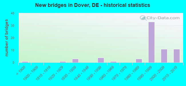
- New bridges - historical statistics
- 1Before 1900
- 11920-1929
- 31930-1939
- 41950-1959
- 11960-1969
- 31980-1989
- 331990-1999
- 112000-2009
- 112010-2019
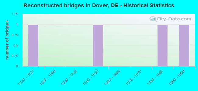
- Reconstructed bridges - Historical Statistics
- 11920-1929
- 01930-1939
- 01940-1949
- 11950-1959
- 01960-1969
- 01970-1979
- 11980-1989
- 11990-1999
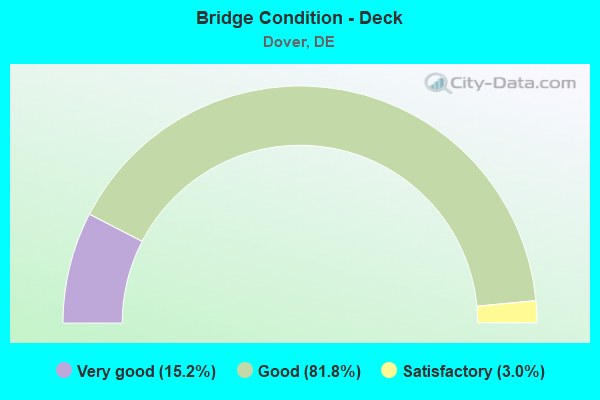
- Bridge Condition - Deck
- 15.2%Very good
- 81.8%Good
- 3.0%Satisfactory
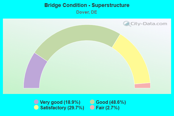
- Bridge Condition - Superstructure
- 18.9%Very good
- 48.6%Good
- 29.7%Satisfactory
- 2.7%Fair
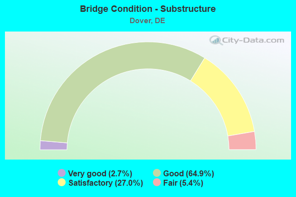
- Bridge Condition - Substructure
- 2.7%Very good
- 64.9%Good
- 27.0%Satisfactory
- 5.4%Fair
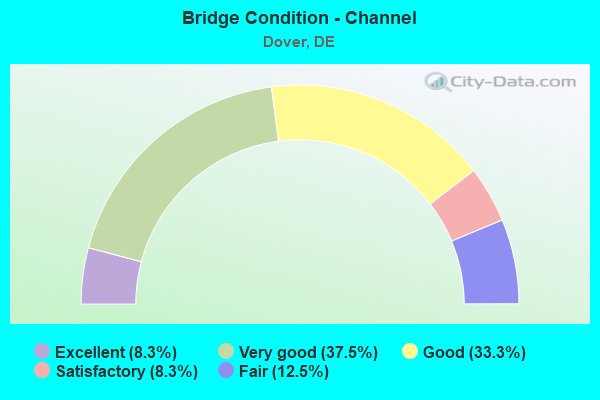
- Bridge Condition - Channel
- 8.3%Excellent
- 37.5%Very good
- 33.3%Good
- 8.3%Satisfactory
- 12.5%Fair
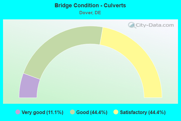
- Bridge Condition - Culverts
- 11.1%Very good
- 44.4%Good
- 44.4%Satisfactory
Find on map >> Show street view
Structure Number: 2003B003, Location: DOVER (Lat: 39.140083, Lng: -75.525753), Route carried "on" structure: Alternate US 13A, Year Built: 2009, Status: Open, Structure Length: 1.03m (3.38ft), Average Daily Traffic: 8,786 (year 2020), Truck Traffic: 7%, Average Future Daily Traffic: 10,920 (year 2043), Design Load: HS 20+Mod, Features Intersected: PUNCHEON RUN, Facility Carried by Structure: S. GOVERNORS AVE
Minimum Vertical Clearance: 30.48m (100.00ft), Kilometerpoint: 1.529, Lanes on structure: 2, Owner: State Highway Agency, Approaching Roadway Width: 14.0m (45.9ft), Skew: 1 degrees, Material/Design: Prestressed concrete, Design/Construction: Box Beam or Girders - Multiple, Number Of Spans In Main Unit: 1, Length of Maximum Span: 9.1m (29.9ft), Curb or Sidewalk Widths: Left: 1.4m (4.6ft), Right: 1.4m (4.6ft), Curb-To-Curb Width: 14.0m (45.9ft), Out-to-Out Width: 17.7m (58.1ft)
Condition: Deck: Good, Superstructure: Very good, Substructure: Good, Channel: Very good, Operating Rating: 56.7 metric tons, Method Used To Determine Operating Rating: Load and Resistance Factor Rating (LRFR) rating reported by rating factor(RF) method using HL-93 loadings, Inventory Rating: 43.7 metric tons, Method Used To Determine Inventory Rating: Load and Resistance Factor Rating (LRFR) rating reported by rating factor(RF) method using HL-93 loadings, Structural Evaluation: Better than present minimum criteria, Deck Geometry: Superior to present desirable criteria, Waterway Adequacy: Equal to present minimum criteria, Approach Roadway Alignment: Equal to present desirable criteria, Designated Inspection Frequency: Every 24 months, Inspection Date: October 2021, Deck Structure Type: Concrete Cast-file-Place, Wearing Surface/Protective System: Wearing Surface: Monolithic Concrete, Deck Protection: Epoxy Coated Reinforcing
Find on map >> Show street view
Structure Number: 2003C003, Location: DOVER (Lat: 39.174231, Lng: -75.529964), Route carried "on" structure: Alternate US 13A, Year Built: 1937, Status: Open, Structure Length: 2.96m (9.71ft), Average Daily Traffic: 14,447 (year 2019), Truck Traffic: 9%, Average Future Daily Traffic: 17,956 (year 2042), Design Load: H 20, Features Intersected: SILVER LAKE, Facility Carried by Structure: NORTH STATE ST
Minimum Vertical Clearance: 30.48m (100.00ft), Kilometerpoint: 5.456, Lanes on structure: 4, Owner: State Highway Agency, Approaching Roadway Width: 14.0m (45.9ft), Material/Design: Concrete, Design/Construction: Arch - Deck, Number Of Spans In Main Unit: 3, Length of Maximum Span: 8.7m (28.5ft), Curb or Sidewalk Widths: Left: 1.7m (5.6ft), Right: 1.7m (5.6ft), Curb-To-Curb Width: 14.0m (45.9ft), Out-to-Out Width: 18.3m (60.0ft)
Condition: Superstructure: Satisfactory, Substructure: Satisfactory, Channel: Good, Operating Rating: 51.2 metric tons, Method Used To Determine Operating Rating: Load and Resistance Factor Rating (LRFR) rating reported by rating factor(RF) method using HL-93 loadings, Inventory Rating: 38.6 metric tons, Method Used To Determine Inventory Rating: Load and Resistance Factor Rating (LRFR) rating reported by rating factor(RF) method using HL-93 loadings, Structural Evaluation: Equal to present minimum criteria, Deck Geometry: High priority of replacement, Waterway Adequacy: Equal to present minimum criteria, Approach Roadway Alignment: Equal to present desirable criteria, Length Of Structure Improvement: 3.37m (11.06ft), Designated Inspection Frequency: Every 24 months, Underwater Inspection Frequency: Every 48 months, Inspection Date: October 2020, Underwater Inspection Date: September 2020, Bridge Improvement Cost: $662,000, Roadway Improvement Cost: $66,000, Total Project Cost: $994,000
Find on map >> Show street view
Structure Number: 2007B008, Location: BARKERS LANDING (Lat: 39.085294, Lng: -75.457239), Route carried "on" structure: US 113, Year Built: 1984, Status: Open, Structure Length: 67.30m (220.80ft), Average Daily Traffic: 29,924 (year 2020), Truck Traffic: 15%, Average Future Daily Traffic: 37,193 (year 2043), Design Load: HS 20+Mod, Features Intersected: ST. JONES RIVER
Minimum Vertical Clearance: 30.48m (100.00ft), Kilometerpoint: 20.406, Lanes on structure: 4, Lanes under structure: 2, Base Highway Network: Yes, Owner: State Highway Agency, Approaching Roadway Width: 23.2m (76.1ft), Skew: 30 degrees, Navigation Control: Yes ( Vertical Clearance: 7.3m (24.0ft), Horizontal Clearance: 15.2m (49.9ft)), Material/Design: Prestressed concrete continuous, Design/Construction: Stringer/Multi-beam, Number Of Spans In Main Unit: 3, Number Of Approach Spans: 34, Length of Maximum Span: 29.0m (95.1ft), Curb-To-Curb Width: 23.2m (76.1ft), Out-to-Out Width: 25.2m (82.7ft)
Condition: Deck: Good, Superstructure: Good, Substructure: Satisfactory, Channel: Very good, Operating Rating: 38.2 metric tons, Method Used To Determine Operating Rating: Load and Resistance Factor Rating (LRFR) rating reported by rating factor(RF) method using HL-93 loadings, Inventory Rating: 30.1 metric tons, Method Used To Determine Inventory Rating: Load and Resistance Factor Rating (LRFR) rating reported by rating factor(RF) method using HL-93 loadings, Structural Evaluation: Equal to present minimum criteria, Deck Geometry: Superior to present desirable criteria, Underclear: Somewhat better than minimum adequacy, Waterway Adequacy: Equal to present desirable criteria, Approach Roadway Alignment: Equal to present desirable criteria, Designated Inspection Frequency: Every 24 months, Underwater Inspection Frequency: Every 48 months, Inspection Date: October 2021, Underwater Inspection Date: August 2021, Deck Structure Type: Concrete Cast-file-Place, Wearing Surface/Protective System: Deck Protection: Epoxy Coated Reinforcing
Find on map >> Show street view
Structure Number: 2016A016, Location: DOVER (Lat: 39.163144, Lng: -75.519003), Route carried "on" structure: State highway 8, Year Built: 1885, Year Reconstructed: 1959, Status: Open, Structure Length: 1.42m (4.66ft), Average Daily Traffic: 10,170 (year 2020), Truck Traffic: 7%, Average Future Daily Traffic: 12,640 (year 2043), Design Load: HS 20, Features Intersected: ST. JONES RIVER
Minimum Vertical Clearance: 30.48m (100.00ft), Kilometerpoint: 0.805, Lanes on structure: 3, Owner: State Highway Agency, Approaching Roadway Width: 11.7m (38.4ft), Skew: 1 degrees, Material/Design: Masonry, Design/Construction: Arch - Deck, Number Of Spans In Main Unit: 3, Length of Maximum Span: 4.3m (14.1ft), Curb or Sidewalk Widths: Left: 1.6m (5.2ft), Right: 1.5m (4.9ft), Curb-To-Curb Width: 13.4m (44.0ft), Out-to-Out Width: 17.4m (57.1ft)
Condition: Superstructure: Satisfactory, Substructure: Satisfactory, Channel: Fair, Operating Rating: 36.9 metric tons, Method Used To Determine Operating Rating: Load and Resistance Factor Rating (LRFR) rating reported by rating factor(RF) method using HL-93 loadings, Inventory Rating: 27.2 metric tons, Method Used To Determine Inventory Rating: Load and Resistance Factor Rating (LRFR) rating reported by rating factor(RF) method using HL-93 loadings, Structural Evaluation: Equal to present minimum criteria, Deck Geometry: Somewhat better than minimum adequacy, Waterway Adequacy: Equal to present minimum criteria, Approach Roadway Alignment: Equal to present desirable criteria, Designated Inspection Frequency: Every 24 months, Inspection Date: August 2021
Find on map >> Show street view
Structure Number: 2016B016, Location: EAST OF DOVER (Lat: 39.166467, Lng: -75.477619), Route carried "on" structure: State highway 8, Year Built: 2014, Status: Open, Structure Length: 0.62m (2.03ft), Average Daily Traffic: 933 (year 2019), Truck Traffic: 10%, Average Future Daily Traffic: 1,385 (year 2038), Design Load: HL 93, Features Intersected: LITTLE RIVER, Facility Carried by Structure: N. LITTLE CREEK RD
Minimum Vertical Clearance: 30.48m (100.00ft), Kilometerpoint: 4.538, Lanes on structure: 2, Owner: State Highway Agency, Approaching Roadway Width: 7.6m (24.9ft), Material/Design: Concrete, Design/Construction: Culvert, Number Of Spans In Main Unit: 1, Length of Maximum Span: 6.2m (20.3ft)
Condition: Channel: Very good, Culverts: Good, Operating Rating: 67.1 metric tons, Method Used To Determine Operating Rating: Load and Resistance Factor Rating (LRFR) rating reported by rating factor(RF) method using HL-93 loadings, Inventory Rating: 51.8 metric tons, Method Used To Determine Inventory Rating: Load and Resistance Factor Rating (LRFR) rating reported by rating factor(RF) method using HL-93 loadings, Structural Evaluation: Better than present minimum criteria, Waterway Adequacy: Equal to present minimum criteria, Approach Roadway Alignment: Equal to present desirable criteria, Length Of Structure Improvement: 1.47m (4.82ft), Designated Inspection Frequency: Every 24 months, Inspection Date: September 2020, Bridge Improvement Cost: $453,000, Roadway Improvement Cost: $68,000, Total Project Cost: $521,000
Find on map >> Show street view
Structure Number: 2017B017, Location: S. OF AIR FORCE BASE (Lat: 39.106306, Lng: -75.455108), Route carried "on" structure: State highway 9, Year Built: 2009, Status: Open, Structure Length: 6.54m (21.46ft), Average Daily Traffic: 2,123 (year 2020), Truck Traffic: 9%, Average Future Daily Traffic: 2,638 (year 2043), Design Load: HS 20+Mod, Features Intersected: BAY RD. / US113/SR1
Minimum Vertical Clearance: 30.48m (100.00ft), Kilometerpoint: 0.161, Lanes on structure: 2, Lanes under structure: 4, Owner: State Highway Agency, Approaching Roadway Width: 8.2m (26.9ft), Material/Design: Prestressed concrete continuous, Design/Construction: Stringer/Multi-beam, Number Of Spans In Main Unit: 2, Length of Maximum Span: 32.0m (105.0ft), Curb-To-Curb Width: 17.1m (56.1ft), Out-to-Out Width: 17.9m (58.7ft)
Condition: Deck: Good, Superstructure: Very good, Substructure: Good, Operating Rating: 51.5 metric tons, Method Used To Determine Operating Rating: Load and Resistance Factor Rating (LRFR) rating reported by rating factor(RF) method using HL-93 loadings, Inventory Rating: 39.9 metric tons, Method Used To Determine Inventory Rating: Load and Resistance Factor Rating (LRFR) rating reported by rating factor(RF) method using HL-93 loadings, Structural Evaluation: Better than present minimum criteria, Deck Geometry: Superior to present desirable criteria, Underclear: Somewhat better than minimum adequacy, Approach Roadway Alignment: Equal to present minimum criteria, Designated Inspection Frequency: Every 24 months, Inspection Date: September 2021, Deck Structure Type: Concrete Cast-file-Place, Wearing Surface/Protective System: Wearing Surface: Monolithic Concrete, Deck Protection: Epoxy Coated Reinforcing
Find on map >> Show street view
Structure Number: 2023A023, Location: DOVER (Lat: 39.159342, Lng: -75.518989), Route carried "on" structure: County highway 23, Year Built: 1934, Status: Open, Structure Length: 1.59m (5.22ft), Average Daily Traffic: 6,205 (year 2020), Truck Traffic: 7%, Average Future Daily Traffic: 7,712 (year 2043), Features Intersected: ST. JONES RIVER, Facility Carried by Structure: LOOCKERMAN ST
Minimum Vertical Clearance: 30.48m (100.00ft), Kilometerpoint: 1.706, Lanes on structure: 2, Owner: State Highway Agency, Approaching Roadway Width: 9.1m (29.9ft), Material/Design: Concrete, Design/Construction: Arch - Deck, Number Of Spans In Main Unit: 1, Length of Maximum Span: 15.9m (52.2ft), Curb or Sidewalk Widths: Left: 1.5m (4.9ft), Right: 1.5m (4.9ft), Curb-To-Curb Width: 9.1m (29.9ft), Out-to-Out Width: 12.9m (42.3ft)
Condition: Superstructure: Good, Substructure: Fair, Channel: Good, Operating Rating: 38.6 metric tons, Method Used To Determine Operating Rating: Load and Resistance Factor Rating (LRFR) rating reported by rating factor(RF) method using HL-93 loadings, Inventory Rating: 29.8 metric tons, Method Used To Determine Inventory Rating: Load and Resistance Factor Rating (LRFR) rating reported by rating factor(RF) method using HL-93 loadings, Structural Evaluation: Somewhat better than minimum adequacy, Deck Geometry: High priority of corrective action, Waterway Adequacy: Equal to present minimum criteria, Approach Roadway Alignment: Equal to present desirable criteria, Length Of Structure Improvement: 1.59m (5.22ft), Designated Inspection Frequency: Every 24 months, Underwater Inspection Frequency: Every 24 months, Inspection Date: August 2021, Underwater Inspection Date: May 2021, Bridge Improvement Cost: $220,000, Roadway Improvement Cost: $22,000, Total Project Cost: $330,000
Find on map >> Show street view
Structure Number: 2024A024, Location: DOVER (Lat: 39.148872, Lng: -75.515244), Route carried "on" structure: US 13, Year Built: 1951, Status: Open, Structure Length: 6.23m (20.44ft), Average Daily Traffic: 24,011 (year 2020), Truck Traffic: 7%, Average Future Daily Traffic: 29,843 (year 2043), Design Load: HS 20, Features Intersected: ST. JONES RIVER
Minimum Vertical Clearance: 30.48m (100.00ft), Kilometerpoint: 12.247, Lanes on structure: 4, Base Highway Network: Yes, Owner: State Highway Agency, Approaching Roadway Width: 9.1m (29.9ft), Skew: 20 degrees, Navigation Control: Yes ( Vertical Clearance: 3.0m (9.8ft), Horizontal Clearance: 24.0m (78.7ft)), Material/Design: Concrete continuous, Design/Construction: Tee Beam, Number Of Spans In Main Unit: 3, Length of Maximum Span: 25.0m (82.0ft), Curb or Sidewalk Widths: Left: 1.5m (4.9ft), Right: 1.5m (4.9ft), Curb-To-Curb Width: 18.3m (60.0ft), Out-to-Out Width: 23.2m (76.1ft)
Condition: Deck: Good, Superstructure: Good, Substructure: Satisfactory, Channel: Very good, Operating Rating: 32.4 metric tons, Method Used To Determine Operating Rating: Load and Resistance Factor Rating (LRFR) rating reported by rating factor(RF) method using HL-93 loadings, Inventory Rating: 24.9 metric tons, Method Used To Determine Inventory Rating: Load and Resistance Factor Rating (LRFR) rating reported by rating factor(RF) method using HL-93 loadings, Structural Evaluation: Equal to present minimum criteria, Deck Geometry: Somewhat better than minimum adequacy, Waterway Adequacy: Equal to present minimum criteria, Approach Roadway Alignment: Equal to present desirable criteria, Designated Inspection Frequency: Every 24 months, Inspection Date: October 2021, Deck Structure Type: Concrete Cast-file-Place, Wearing Surface/Protective System: Wearing Surface: Latex Concrete
Find on map >> Show street view
Structure Number: 2024B024, Location: DOVER (Lat: 39.139072, Lng: -75.524358), Route carried "on" structure: US 13, Year Built: 1951, Year Reconstructed: 1991, Status: Open, Structure Length: 1.30m (4.27ft), Average Daily Traffic: 20,089 (year 2020), Truck Traffic: 7%, Average Future Daily Traffic: 24,969 (year 2043), Design Load: HS 20, Features Intersected: PUNCHEON RUN
Minimum Vertical Clearance: 30.48m (100.00ft), Kilometerpoint: 10.879, Lanes on structure: 4, Base Highway Network: Yes, Owner: State Highway Agency, Approaching Roadway Width: 23.2m (76.1ft), Skew: 23 degrees, Material/Design: Concrete, Design/Construction: Culvert, Number Of Spans In Main Unit: 4, Length of Maximum Span: 3.7m (12.1ft), Curb-To-Curb Width: 37.5m (123.0ft), Out-to-Out Width: 38.4m (126.0ft)
Condition: Channel: Fair, Culverts: Satisfactory, Operating Rating: 34.3 metric tons, Method Used To Determine Operating Rating: Load and Resistance Factor Rating (LRFR) rating reported by rating factor(RF) method using HL-93 loadings, Inventory Rating: 24.3 metric tons, Method Used To Determine Inventory Rating: Load and Resistance Factor Rating (LRFR) rating reported by rating factor(RF) method using HL-93 loadings, Structural Evaluation: Equal to present minimum criteria, Deck Geometry: Superior to present desirable criteria, Waterway Adequacy: Equal to present minimum criteria, Approach Roadway Alignment: Equal to present desirable criteria, Designated Inspection Frequency: Every 24 months, Inspection Date: October 2021, Deck Structure Type: Concrete Cast-file-Place, Wearing Surface/Protective System: Wearing Surface: Bituminous
Find on map >> Show street view
Structure Number: 2027D027, Location: DOVER (Lat: 39.139222, Lng: -75.522769), Route carried "on" structure: US 113A, Year Built: 1957, Year Reconstructed: 1999, Status: Open, Structure Length: 1.10m (3.61ft), Average Daily Traffic: 17,532 (year 2019), Truck Traffic: 9%, Average Future Daily Traffic: 21,790 (year 2042), Design Load: HS 20, Features Intersected: PUNCHEON RUN, Facility Carried by Structure: STATE ST
Minimum Vertical Clearance: 30.48m (100.00ft), Kilometerpoint: 12.006, Lanes on structure: 6, Base Highway Network: Yes, Owner: State Highway Agency, Approaching Roadway Width: 30.5m (100.1ft), Skew: 20 degrees, Material/Design: Concrete, Design/Construction: Culvert, Number Of Spans In Main Unit: 3, Length of Maximum Span: 3.0m (9.8ft)
Condition: Channel: Good, Culverts: Satisfactory, Operating Rating: 57.7 metric tons, Method Used To Determine Operating Rating: Load and Resistance Factor Rating (LRFR) rating reported by rating factor(RF) method using HL-93 loadings, Inventory Rating: 45.4 metric tons, Method Used To Determine Inventory Rating: Load and Resistance Factor Rating (LRFR) rating reported by rating factor(RF) method using HL-93 loadings, Structural Evaluation: Equal to present minimum criteria, Waterway Adequacy: Equal to present minimum criteria, Approach Roadway Alignment: Equal to present desirable criteria, Designated Inspection Frequency: Every 24 months, Inspection Date: October 2020
Find on map >> Show street view
Structure Number: 2066A066, Location: EAST DOVER (Lat: 39.178339, Lng: -75.497469), Route carried "on" structure: County highway 66, Year Built: 2019, Status: Open, Structure Length: 0.67m (2.20ft), Average Daily Traffic: 1,965 (year 2020), Truck Traffic: 13%, Average Future Daily Traffic: 2,442 (year 2043), Design Load: HL 93, Features Intersected: LITTLE RIVER, Facility Carried by Structure: WHITE OAK RD
Minimum Vertical Clearance: 30.48m (100.00ft), Kilometerpoint: 2.704, Lanes on structure: 2, Owner: State Highway Agency, Approaching Roadway Width: 7.0m (23.0ft), Material/Design: Concrete, Design/Construction: Culvert, Number Of Spans In Main Unit: 3, Length of Maximum Span: 1.7m (5.6ft)
Condition: Channel: Very good, Culverts: Very good, Operating Rating: 54.4 metric tons, Method Used To Determine Operating Rating: Field evaluation and documented engineering judgment, Inventory Rating: 32.7 metric tons, Method Used To Determine Inventory Rating: Field evaluation and documented engineering judgment, Structural Evaluation: Equal to present desirable criteria, Waterway Adequacy: Better than present minimum criteria, Approach Roadway Alignment: Equal to present desirable criteria, Designated Inspection Frequency: Every 24 months, Inspection Date: August 2021
Find on map >> Show street view
Structure Number: 2066B066, Location: EAST OF DOVER (Lat: 39.176717, Lng: -75.502522), Route carried "on" structure: County highway 66, Year Built: 1990, Status: Open, Structure Length: 6.94m (22.77ft), Average Daily Traffic: 1,965 (year 2020), Truck Traffic: 13%, Average Future Daily Traffic: 2,442 (year 2043), Design Load: HS 25 or greater, Features Intersected: SR1/KOREAN WAR VET MEM
Minimum Vertical Clearance: 30.48m (100.00ft), Kilometerpoint: 2.205, Lanes on structure: 2, Lanes under structure: 4, Owner: State Highway Agency, Approaching Roadway Width: 7.0m (23.0ft), Skew: 2 degrees, Material/Design: Steel continuous, Design/Construction: Stringer/Multi-beam, Number Of Spans In Main Unit: 2, Length of Maximum Span: 33.5m (109.9ft), Curb-To-Curb Width: 14.0m (45.9ft), Out-to-Out Width: 14.8m (48.6ft)
Condition: Deck: Good, Superstructure: Good, Substructure: Satisfactory, Operating Rating: 35.3 metric tons, Method Used To Determine Operating Rating: Load and Resistance Factor Rating (LRFR) rating reported by rating factor(RF) method using HL-93 loadings, Inventory Rating: 26.9 metric tons, Method Used To Determine Inventory Rating: Load and Resistance Factor Rating (LRFR) rating reported by rating factor(RF) method using HL-93 loadings, Structural Evaluation: Equal to present minimum criteria, Deck Geometry: Superior to present desirable criteria, Underclear: Equal to present minimum criteria, Approach Roadway Alignment: Equal to present desirable criteria, Designated Inspection Frequency: Every 24 months, Inspection Date: August 2021, Deck Structure Type: Concrete Cast-file-Place, Wearing Surface/Protective System: Wearing Surface: Monolithic Concrete, Deck Protection: Epoxy Coated Reinforcing
Find on map >> Show street view
Structure Number: 2067A067, Location: DOVER (Lat: 39.157775, Lng: -75.517511), Route carried "on" structure: County highway 67, Year Built: 1957, Status: Open, Structure Length: 1.83m (6.00ft), Average Daily Traffic: 8,700 (year 2020), Truck Traffic: 7%, Average Future Daily Traffic: 10,813 (year 2043), Design Load: HS 20, Features Intersected: ST. JONES RIVER, Facility Carried by Structure: M.L.K. JR. BLVD.
Minimum Vertical Clearance: 30.48m (100.00ft), Kilometerpoint: 0.740, Lanes on structure: 4, Owner: State Highway Agency, Approaching Roadway Width: 18.3m (60.0ft), Skew: 22 degrees, Material/Design: Concrete, Design/Construction: Arch - Deck, Number Of Spans In Main Unit: 1, Length of Maximum Span: 18.3m (60.0ft), Curb or Sidewalk Widths: Left: 3.9m (12.8ft), Right: 3.9m (12.8ft), Curb-To-Curb Width: 18.3m (60.0ft), Out-to-Out Width: 27.5m (90.2ft)
Condition: Superstructure: Satisfactory, Substructure: Good, Channel: Good, Operating Rating: 71.0 metric tons, Method Used To Determine Operating Rating: Load and Resistance Factor Rating (LRFR) rating reported by rating factor(RF) method using HL-93 loadings, Inventory Rating: 54.8 metric tons, Method Used To Determine Inventory Rating: Load and Resistance Factor Rating (LRFR) rating reported by rating factor(RF) method using HL-93 loadings, Structural Evaluation: Equal to present minimum criteria, Deck Geometry: Somewhat better than minimum adequacy, Waterway Adequacy: Better than present minimum criteria, Approach Roadway Alignment: Equal to present desirable criteria, Designated Inspection Frequency: Every 24 months, Inspection Date: August 2021
Find on map >> Show street view
Structure Number: 2069A099, Location: DEL STATE COLLEGE (Lat: 39.182783, Lng: -75.545281), Route carried "on" structure: County highway 99, Year Built: 1968, Status: Open, Structure Length: 1.65m (5.41ft), Average Daily Traffic: 8,456 (year 2020), Truck Traffic: 7%, Average Future Daily Traffic: 10,510 (year 2043), Design Load: HS 20, Features Intersected: FORK BRANCH, Facility Carried by Structure: COLLEGE RD
Minimum Vertical Clearance: 30.48m (100.00ft), Kilometerpoint: 2.334, Lanes on structure: 2, Owner: State Highway Agency, Approaching Roadway Width: 13.4m (44.0ft), Skew: 2 degrees, Material/Design: Prestressed concrete, Design/Construction: Box Beam or Girders - Multiple, Number Of Spans In Main Unit: 1, Length of Maximum Span: 15.2m (49.9ft), Curb or Sidewalk Widths: Left: 1.2m (3.9ft), Right: 1.2m (3.9ft), Curb-To-Curb Width: 13.4m (44.0ft), Out-to-Out Width: 16.5m (54.1ft)
Condition: Deck: Satisfactory, Superstructure: Satisfactory, Substructure: Fair, Channel: Satisfactory, Operating Rating: 59.3 metric tons, Method Used To Determine Operating Rating: Load and Resistance Factor Rating (LRFR) rating reported by rating factor(RF) method using HL-93 loadings, Inventory Rating: 47.0 metric tons, Method Used To Determine Inventory Rating: Load and Resistance Factor Rating (LRFR) rating reported by rating factor(RF) method using HL-93 loadings, Structural Evaluation: Somewhat better than minimum adequacy, Deck Geometry: Equal to present minimum criteria, Waterway Adequacy: Equal to present minimum criteria, Approach Roadway Alignment: Equal to present desirable criteria, Designated Inspection Frequency: Every 24 months, Inspection Date: August 2021, Deck Structure Type: Concrete Precast Panels, Wearing Surface/Protective System: Wearing Surface: Bituminous
Find on map >> Show street view
Structure Number: 2088A088, Location: NEAR DOVER DOWNS (Lat: 39.197367, Lng: -75.529553), Route carried "on" structure: County highway 88, Year Built: 1991, Status: Open, Structure Length: 0.64m (2.10ft), Average Daily Traffic: 1,677 (year 2020), Truck Traffic: 16%, Average Future Daily Traffic: 2,084 (year 2043), Design Load: HS 20, Features Intersected: MUDDY BRANCH, Facility Carried by Structure: LEIPSIC RD
Minimum Vertical Clearance: 30.48m (100.00ft), Kilometerpoint: 2.269, Lanes on structure: 2, Owner: State Highway Agency, Approaching Roadway Width: 7.4m (24.3ft), Skew: 1 degrees, Material/Design: Concrete, Design/Construction: Culvert, Number Of Spans In Main Unit: 4, Length of Maximum Span: 1.2m (3.9ft)
Condition: Channel: Satisfactory, Culverts: Satisfactory, Operating Rating: 54.4 metric tons, Method Used To Determine Operating Rating: Field evaluation and documented engineering judgment, Inventory Rating: 32.7 metric tons, Method Used To Determine Inventory Rating: Field evaluation and documented engineering judgment, Structural Evaluation: Equal to present minimum criteria, Waterway Adequacy: Equal to present minimum criteria, Approach Roadway Alignment: Equal to present desirable criteria, Designated Inspection Frequency: Every 24 months, Underwater Inspection Frequency: Every 48 months, Inspection Date: August 2021, Underwater Inspection Date: August 2021
Find on map >> Show street view
Structure Number: 2088B088, Location: EAST OF DOVER DOWNS (Lat: 39.192144, Lng: -75.525422), Route carried "on" structure: County highway 88, Year Built: 1993, Status: Open, Structure Length: 6.62m (21.72ft), Average Daily Traffic: 2,020 (year 2020), Truck Traffic: 7%, Average Future Daily Traffic: 2,510 (year 2043), Design Load: HS 25 or greater, Features Intersected: SR1/KOREAN WAR VET MEM
Minimum Vertical Clearance: 30.48m (100.00ft), Kilometerpoint: 1.384, Lanes on structure: 2, Lanes under structure: 5, Owner: State Highway Agency, Approaching Roadway Width: 13.7m (44.9ft), Skew: 1 degrees, Material/Design: Steel continuous, Design/Construction: Stringer/Multi-beam, Number Of Spans In Main Unit: 2, Length of Maximum Span: 32.0m (105.0ft), Curb-To-Curb Width: 14.6m (47.9ft), Out-to-Out Width: 15.4m (50.5ft)
Condition: Deck: Good, Superstructure: Very good, Substructure: Good, Operating Rating: 77.2 metric tons, Method Used To Determine Operating Rating: Load Factor (LF), Inventory Rating: 48.2 metric tons, Method Used To Determine Inventory Rating: Load Factor (LF), Structural Evaluation: Better than present minimum criteria, Deck Geometry: Superior to present desirable criteria, Underclear: Equal to present minimum criteria, Approach Roadway Alignment: Equal to present desirable criteria, Designated Inspection Frequency: Every 24 months, Inspection Date: September 2021, Deck Structure Type: Concrete Cast-file-Place, Wearing Surface/Protective System: Wearing Surface: Monolithic Concrete, Deck Protection: Epoxy Coated Reinforcing
Find on map >> Show street view
Structure Number: 2100A1, Location: NORTH OF DOVER (Lat: 39.195603, Lng: -75.564147), Route carried "on" structure: County highway 100, Year Built: 2015, Status: Open, Structure Length: 0.66m (2.17ft), Average Daily Traffic: 1,486 (year 2020), Truck Traffic: 7%, Average Future Daily Traffic: 1,846 (year 2043), Design Load: HS 20, Features Intersected: FORK BRANCH, Facility Carried by Structure: DENNEYS RD
Minimum Vertical Clearance: 30.48m (100.00ft), Kilometerpoint: 8.401, Lanes on structure: 2, Owner: State Highway Agency, Approaching Roadway Width: 9.8m (32.2ft), Material/Design: Concrete, Design/Construction: Culvert, Number Of Spans In Main Unit: 1, Length of Maximum Span: 6.6m (21.7ft), Curb-To-Curb Width: 9.8m (32.2ft), Out-to-Out Width: 11.0m (36.1ft)
Condition: Channel: Very good, Culverts: Good, Operating Rating: 71.0 metric tons, Method Used To Determine Operating Rating: Load and Resistance Factor Rating (LRFR) rating reported by rating factor(RF) method using HL-93 loadings, Inventory Rating: 54.8 metric tons, Method Used To Determine Inventory Rating: Load and Resistance Factor Rating (LRFR) rating reported by rating factor(RF) method using HL-93 loadings, Structural Evaluation: Better than present minimum criteria, Deck Geometry: Somewhat better than minimum adequacy, Waterway Adequacy: Better than present minimum criteria, Approach Roadway Alignment: Equal to present desirable criteria, Length Of Structure Improvement: 0.73m (2.40ft), Designated Inspection Frequency: Every 24 months, Inspection Date: August 2021, Bridge Improvement Cost: $105,000, Roadway Improvement Cost: $11,000, Total Project Cost: $158,000
Find on map >> Show street view
Structure Number: 2104A104, Location: WEST DOVER (Lat: 39.173064, Lng: -75.578861), Route carried "on" structure: County highway 104, Year Built: 1934, Status: Open, Structure Length: 0.79m (2.59ft), Average Daily Traffic: 7,242 (year 2019), Truck Traffic: 9%, Average Future Daily Traffic: 9,001 (year 2042), Design Load: H 20, Features Intersected: CAHOON BROOK, Facility Carried by Structure: KENTON RD
Minimum Vertical Clearance: 30.48m (100.00ft), Kilometerpoint: 2.640, Lanes on structure: 2, Owner: State Highway Agency, Approaching Roadway Width: 8.5m (27.9ft), Material/Design: Concrete, Design/Construction: Slab, Number Of Spans In Main Unit: 1, Length of Maximum Span: 6.7m (22.0ft), Curb-To-Curb Width: 9.6m (31.5ft), Out-to-Out Width: 10.7m (35.1ft)
Condition: Deck: Good, Superstructure: Good, Substructure: Good, Channel: Good, Operating Rating: 36.6 metric tons, Method Used To Determine Operating Rating: Load and Resistance Factor Rating (LRFR) rating reported by rating factor(RF) method using HL-93 loadings, Inventory Rating: 28.2 metric tons, Method Used To Determine Inventory Rating: Load and Resistance Factor Rating (LRFR) rating reported by rating factor(RF) method using HL-93 loadings, Structural Evaluation: Better than present minimum criteria, Deck Geometry: High priority of corrective action, Waterway Adequacy: Equal to present minimum criteria, Approach Roadway Alignment: Equal to present desirable criteria, Length Of Structure Improvement: 0.79m (2.59ft), Designated Inspection Frequency: Every 24 months, Inspection Date: October 2020, Bridge Improvement Cost: $800,000, Roadway Improvement Cost: $200,000, Total Project Cost: $1,000,000, Deck Structure Type: Concrete Cast-file-Place, Wearing Surface/Protective System: Wearing Surface: Bituminous
Find on map >> Show street view
Structure Number: 2104B104, Location: NORTHWEST DOVER (Lat: 39.177064, Lng: -75.581531), Route carried "on" structure: County highway 104, Year Built: 1920, Year Reconstructed: 1934, Status: Open, Structure Length: 0.62m (2.03ft), Average Daily Traffic: 5,757 (year 2020), Truck Traffic: 7%, Average Future Daily Traffic: 7,155 (year 2043), Design Load: H 15, Features Intersected: MUDSTONE BRANCH
Minimum Vertical Clearance: 30.48m (100.00ft), Kilometerpoint: 3.154, Lanes on structure: 2, Owner: State Highway Agency, Approaching Roadway Width: 8.1m (26.6ft), Material/Design: Concrete, Design/Construction: Culvert, Number Of Spans In Main Unit: 1, Length of Maximum Span: 6.2m (20.3ft)
Condition: Channel: Good, Culverts: Satisfactory, Operating Rating: 43.1 metric tons, Method Used To Determine Operating Rating: Load and Resistance Factor Rating (LRFR) rating reported by rating factor(RF) method using HL-93 loadings, Inventory Rating: 33.0 metric tons, Method Used To Determine Inventory Rating: Load and Resistance Factor Rating (LRFR) rating reported by rating factor(RF) method using HL-93 loadings, Structural Evaluation: Equal to present minimum criteria, Waterway Adequacy: Better than present minimum criteria, Approach Roadway Alignment: Equal to present desirable criteria, Designated Inspection Frequency: Every 24 months, Inspection Date: September 2021
Find on map >> Show street view
Structure Number: 2156A156, Location: NORTH DOVER (Lat: 39.198931, Lng: -75.577539), Route carried "on" structure: County highway 156, Year Built: 1986, Status: Open, Structure Length: 0.98m (3.22ft), Average Daily Traffic: 6,503 (year 2019), Truck Traffic: 8%, Average Future Daily Traffic: 8,082 (year 2042), Design Load: HS 20, Features Intersected: FORK BRANCH, Facility Carried by Structure: MCKEE RD.
Minimum Vertical Clearance: 30.48m (100.00ft), Kilometerpoint: 6.310, Lanes on structure: 2, Owner: State Highway Agency, Approaching Roadway Width: 8.5m (27.9ft), Material/Design: Wood or Timber, Design/Construction: Slab, Number Of Spans In Main Unit: 1, Length of Maximum Span: 9.4m (30.8ft), Curb-To-Curb Width: 10.4m (34.1ft), Out-to-Out Width: 10.7m (35.1ft)
Condition: Deck: Good, Superstructure: Good, Substructure: Good, Channel: Very good, Operating Rating: 53.5 metric tons, Method Used To Determine Operating Rating: Load Factor (LF), Inventory Rating: 36.9 metric tons, Method Used To Determine Inventory Rating: Load Factor (LF), Structural Evaluation: Better than present minimum criteria, Deck Geometry: Meets minimum limits, Waterway Adequacy: Better than present minimum criteria, Approach Roadway Alignment: Equal to present desirable criteria, Designated Inspection Frequency: Every 24 months, Inspection Date: November 2020, Bridge Improvement Cost: $800,000, Roadway Improvement Cost: $200,000, Total Project Cost: $1,000,000, Deck Structure Type: Wood or Timber, Wearing Surface/Protective System: Wearing Surface: Bituminous
Find on map >> Show street view
Structure Number: 2156C156, Location: N/W OF DOVER (Lat: 39.188569, Lng: -75.567569), Route carried "on" structure: State highway 15, Year Built: 1996, Status: Open, Structure Length: 1.97m (6.46ft), Average Daily Traffic: 4,783 (year 2019), Truck Traffic: 9%, Average Future Daily Traffic: 5,944 (year 2042), Design Load: HS 25 or greater, Features Intersected: MUDSTONE BRANCH, Facility Carried by Structure: MCKEE RD.
Minimum Vertical Clearance: 30.48m (100.00ft), Kilometerpoint: 4.699, Lanes on structure: 2, Owner: State Highway Agency, Approaching Roadway Width: 8.6m (28.2ft), Material/Design: Prestressed concrete, Design/Construction: Box Beam or Girders - Multiple, Number Of Spans In Main Unit: 1, Length of Maximum Span: 18.3m (60.0ft), Curb-To-Curb Width: 13.4m (44.0ft), Out-to-Out Width: 14.2m (46.6ft)
Condition: Deck: Good, Superstructure: Good, Substructure: Good, Channel: Good, Operating Rating: 62.5 metric tons, Method Used To Determine Operating Rating: Load and Resistance Factor Rating (LRFR) rating reported by rating factor(RF) method using HL-93 loadings, Inventory Rating: 50.5 metric tons, Method Used To Determine Inventory Rating: Load and Resistance Factor Rating (LRFR) rating reported by rating factor(RF) method using HL-93 loadings, Structural Evaluation: Better than present minimum criteria, Deck Geometry: Better than present minimum criteria, Waterway Adequacy: Equal to present minimum criteria, Approach Roadway Alignment: Equal to present desirable criteria, Designated Inspection Frequency: Every 24 months, Inspection Date: September 2020, Bridge Improvement Cost: $1,000, Deck Structure Type: Concrete Cast-file-Place, Wearing Surface/Protective System: Wearing Surface: Epoxy Overlay, Deck Protection: Epoxy Coated Reinforcing
Find on map >> Show street view
Structure Number: 2156N151, Location: WEST DOVER (Lat: 39.140694, Lng: -75.539417), Route carried "on" structure: State highway 156, Year Built: 2017, Status: Open, Structure Length: 22.31m (73.20ft), Average Daily Traffic: 3,782 (year 2020), Truck Traffic: 7%, Average Future Daily Traffic: 9,860 (year 2041), Design Load: HL 93, Features Intersected: N/S RR & PUNCHEON RUN, Facility Carried by Structure: POW MIA PARKWAY
Minimum Vertical Clearance: 30.48m (100.00ft), Kilometerpoint: 3.219, Lanes on structure: 1, Owner: State Highway Agency, Approaching Roadway Width: 7.4m (24.3ft), Skew: 3 degrees, Material/Design: Prestressed concrete, Design/Construction: Stringer/Multi-beam, Number Of Spans In Main Unit: 6, Length of Maximum Span: 42.1m (138.1ft), Curb-To-Curb Width: 8.2m (26.9ft), Out-to-Out Width: 9.1m (29.9ft)
Condition: Deck: Good, Superstructure: Good, Substructure: Good, Channel: Excellent, Operating Rating: 43.7 metric tons, Method Used To Determine Operating Rating: Load and Resistance Factor Rating (LRFR) rating reported by rating factor(RF) method using HL-93 loadings, Inventory Rating: 33.7 metric tons, Method Used To Determine Inventory Rating: Load and Resistance Factor Rating (LRFR) rating reported by rating factor(RF) method using HL-93 loadings, Structural Evaluation: Better than present minimum criteria, Deck Geometry: High priority of corrective action, Underclear: Better than present minimum criteria, Waterway Adequacy: Equal to present desirable criteria, Approach Roadway Alignment: Equal to present desirable criteria, Designated Inspection Frequency: Every 24 months, Inspection Date: September 2021, Deck Structure Type: Concrete Cast-file-Place, Wearing Surface/Protective System: Wearing Surface: Integral Concrete, Deck Protection: Epoxy Coated Reinforcing
Find on map >> Show street view
Structure Number: 2156S151, Location: WEST DOVER (Lat: 39.140694, Lng: -75.539583), Route carried "on" structure: State highway 156, Year Built: 2017, Status: Open, Structure Length: 22.31m (73.20ft), Average Daily Traffic: 3,782 (year 2020), Truck Traffic: 7%, Average Future Daily Traffic: 9,860 (year 2041), Design Load: HL 93, Features Intersected: N/S RR & PUNCHEON RUN, Facility Carried by Structure: POW MIA PARKWAY
Minimum Vertical Clearance: 30.48m (100.00ft), Kilometerpoint: 3.219, Lanes on structure: 1, Owner: State Highway Agency, Approaching Roadway Width: 7.3m (24.0ft), Skew: 3 degrees, Material/Design: Prestressed concrete, Design/Construction: Stringer/Multi-beam, Number Of Spans In Main Unit: 6, Length of Maximum Span: 42.1m (138.1ft), Curb or Sidewalk Widths: Left: 2.6m (8.5ft), Right: 0.0m, Curb-To-Curb Width: 8.2m (26.9ft), Out-to-Out Width: 12.0m (39.4ft)
Condition: Deck: Very good, Superstructure: Good, Substructure: Good, Channel: Excellent, Operating Rating: 43.4 metric tons, Method Used To Determine Operating Rating: Load and Resistance Factor Rating (LRFR) rating reported by rating factor(RF) method using HL-93 loadings, Inventory Rating: 33.4 metric tons, Method Used To Determine Inventory Rating: Load and Resistance Factor Rating (LRFR) rating reported by rating factor(RF) method using HL-93 loadings, Structural Evaluation: Better than present minimum criteria, Deck Geometry: High priority of corrective action, Underclear: Superior to present desirable criteria, Waterway Adequacy: Equal to present desirable criteria, Approach Roadway Alignment: Equal to present desirable criteria, Designated Inspection Frequency: Every 24 months, Inspection Date: September 2021, Deck Structure Type: Concrete Cast-file-Place, Wearing Surface/Protective System: Wearing Surface: Integral Concrete, Deck Protection: Epoxy Coated Reinforcing
Find on map >> Show street view
Structure Number: 2157N151, Location: WEST DOVER (Lat: 39.130167, Lng: -75.548167), Route carried "on" structure: State highway 151, Year Built: 2017, Status: Open, Structure Length: 4.72m (15.49ft), Average Daily Traffic: 3,223 (year 2020), Truck Traffic: 7%, Average Future Daily Traffic: 10,264 (year 2041), Design Load: HL 93, Features Intersected: NEW BURTON RD & N/S RR, Facility Carried by Structure: POW MIA PARKWAY
Minimum Vertical Clearance: 30.48m (100.00ft), Kilometerpoint: 1.609, Lanes on structure: 2, Lanes under structure: 2, Owner: State Highway Agency, Approaching Roadway Width: 7.3m (24.0ft), Skew: 1 degrees, Material/Design: Prestressed concrete, Design/Construction: Stringer/Multi-beam, Number Of Spans In Main Unit: 2, Length of Maximum Span: 24.2m (79.4ft), Curb-To-Curb Width: 8.2m (26.9ft), Out-to-Out Width: 12.3m (40.4ft)
Condition: Deck: Very good, Superstructure: Very good, Substructure: Satisfactory, Operating Rating: 37.3 metric tons, Method Used To Determine Operating Rating: Load and Resistance Factor Rating (LRFR) rating reported by rating factor(RF) method using HL-93 loadings, Inventory Rating: 28.8 metric tons, Method Used To Determine Inventory Rating: Load and Resistance Factor Rating (LRFR) rating reported by rating factor(RF) method using HL-93 loadings, Structural Evaluation: Equal to present minimum criteria, Deck Geometry: High priority of corrective action, Underclear: Somewhat better than minimum adequacy, Approach Roadway Alignment: Equal to present desirable criteria, Designated Inspection Frequency: Every 24 months, Inspection Date: September 2021, Deck Structure Type: Concrete Cast-file-Place, Wearing Surface/Protective System: Wearing Surface: Integral Concrete, Deck Protection: Epoxy Coated Reinforcing
Find on map >> Show street view
Structure Number: 2157S151, Location: WEST DOVER (Lat: 39.130056, Lng: -75.548250), Route carried "on" structure: State highway 151, Year Built: 2017, Status: Open, Structure Length: 4.72m (15.49ft), Average Daily Traffic: 3,223 (year 2020), Truck Traffic: 7%, Average Future Daily Traffic: 10,264 (year 2041), Design Load: HL 93, Features Intersected: NEW BURTON RD & N/S RR, Facility Carried by Structure: POW MIA PARKWAY
Minimum Vertical Clearance: 30.48m (100.00ft), Kilometerpoint: 0.000, Lanes on structure: 1, Lanes under structure: 2, Owner: State Highway Agency, Approaching Roadway Width: 7.3m (24.0ft), Skew: 1 degrees, Material/Design: Prestressed concrete, Design/Construction: Stringer/Multi-beam, Number Of Spans In Main Unit: 2, Length of Maximum Span: 24.2m (79.4ft), Curb or Sidewalk Widths: Left: 0.0m, Right: 2.6m (8.5ft), Curb-To-Curb Width: 8.2m (26.9ft), Out-to-Out Width: 12.0m (39.4ft)
Condition: Deck: Very good, Superstructure: Very good, Substructure: Good, Operating Rating: 33.4 metric tons, Method Used To Determine Operating Rating: Load and Resistance Factor Rating (LRFR) rating reported by rating factor(RF) method using HL-93 loadings, Inventory Rating: 25.6 metric tons, Method Used To Determine Inventory Rating: Load and Resistance Factor Rating (LRFR) rating reported by rating factor(RF) method using HL-93 loadings, Structural Evaluation: Equal to present minimum criteria, Deck Geometry: High priority of corrective action, Underclear: Somewhat better than minimum adequacy, Approach Roadway Alignment: Equal to present desirable criteria, Designated Inspection Frequency: Every 24 months, Inspection Date: September 2021, Deck Structure Type: Concrete Cast-file-Place, Wearing Surface/Protective System: Wearing Surface: Integral Concrete, Deck Protection: Epoxy Coated Reinforcing
Find on map >> Show street view
Structure Number: 2158A158, Location: WEST OF DOVER (Lat: 39.168222, Lng: -75.576667), Route carried "on" structure: County highway 158, Year Built: 2013, Status: Open, Structure Length: 0.68m (2.23ft), Average Daily Traffic: 2,790 (year 2018), Truck Traffic: 9%, Average Future Daily Traffic: 4,379 (year 2038), Design Load: HL 93, Features Intersected: CAHOON BRANCH, Facility Carried by Structure: CHESTNUT GROVE RD
Minimum Vertical Clearance: 30.48m (100.00ft), Kilometerpoint: 3.750, Lanes on structure: 2, Owner: State Highway Agency, Approaching Roadway Width: 6.2m (20.3ft), Material/Design: Concrete, Design/Construction: Culvert, Number Of Spans In Main Unit: 1, Length of Maximum Span: 6.2m (20.3ft)
Condition: Channel: Very good, Culverts: Good, Operating Rating: 68.0 metric tons, Method Used To Determine Operating Rating: Load and Resistance Factor Rating (LRFR) rating reported by rating factor(RF) method using HL-93 loadings, Inventory Rating: 52.5 metric tons, Method Used To Determine Inventory Rating: Load and Resistance Factor Rating (LRFR) rating reported by rating factor(RF) method using HL-93 loadings, Structural Evaluation: Better than present minimum criteria, Waterway Adequacy: Better than present minimum criteria, Approach Roadway Alignment: Equal to present desirable criteria, Length Of Structure Improvement: 1.30m (4.27ft), Designated Inspection Frequency: Every 24 months, Inspection Date: Febuary 2020, Bridge Improvement Cost: $269,000, Roadway Improvement Cost: $27,000, Total Project Cost: $296,000
Find on map >> Show street view
Structure Number: 2162A162, Location: WEST OF DOVER (Lat: 39.157261, Lng: -75.584978), Route carried "on" structure: County highway 162, Year Built: 1996, Status: Open, Structure Length: 0.98m (3.22ft), Average Daily Traffic: 653 (year 2019), Truck Traffic: 10%, Average Future Daily Traffic: 811 (year 2042), Design Load: HS 25 or greater, Features Intersected: CAHOON BRANCH, Facility Carried by Structure: SHARON HILL RD
Minimum Vertical Clearance: 30.48m (100.00ft), Kilometerpoint: 0.180, Lanes on structure: 2, Owner: State Highway Agency, Approaching Roadway Width: 6.7m (22.0ft), Material/Design: Prestressed concrete, Design/Construction: Box Beam or Girders - Multiple, Number Of Spans In Main Unit: 1, Length of Maximum Span: 8.9m (29.2ft), Curb-To-Curb Width: 11.5m (37.7ft), Out-to-Out Width: 12.3m (40.4ft)
Condition: Deck: Good, Superstructure: Good, Substructure: Satisfactory, Channel: Good, Operating Rating: 52.2 metric tons, Method Used To Determine Operating Rating: Load and Resistance Factor Rating (LRFR) rating reported by rating factor(RF) method using HL-93 loadings, Inventory Rating: 41.1 metric tons, Method Used To Determine Inventory Rating: Load and Resistance Factor Rating (LRFR) rating reported by rating factor(RF) method using HL-93 loadings, Structural Evaluation: Equal to present minimum criteria, Deck Geometry: Better than present minimum criteria, Waterway Adequacy: Better than present minimum criteria, Approach Roadway Alignment: Equal to present minimum criteria, Designated Inspection Frequency: Every 24 months, Inspection Date: October 2020, Bridge Improvement Cost: $800,000, Roadway Improvement Cost: $200,000, Total Project Cost: $1,000,000, Deck Structure Type: Concrete Cast-file-Place, Wearing Surface/Protective System: Wearing Surface: Monolithic Concrete, Deck Protection: Epoxy Coated Reinforcing
Find on map >> Show street view
Structure Number: 2163A163, Location: WEST OF DOVER (Lat: 39.163419, Lng: -75.632914), Route carried "on" structure: County highway 163, Year Built: 2012, Status: Open, Structure Length: 0.62m (2.03ft), Average Daily Traffic: 594 (year 2019), Truck Traffic: 10%, Average Future Daily Traffic: 620 (year 2038), Design Load: HS 20, Features Intersected: PENROSE BRANCH, Facility Carried by Structure: VICTORY CHAPEL RD
Minimum Vertical Clearance: 30.48m (100.00ft), Kilometerpoint: 0.917, Lanes on structure: 2, Owner: State Highway Agency, Approaching Roadway Width: 5.5m (18.0ft), Material/Design: Concrete, Design/Construction: Culvert, Number Of Spans In Main Unit: 1, Length of Maximum Span: 6.2m (20.3ft)
Condition: Channel: Fair, Culverts: Good, Operating Rating: 46.0 metric tons, Method Used To Determine Operating Rating: Load and Resistance Factor Rating (LRFR) rating reported by rating factor(RF) method using HL-93 loadings, Inventory Rating: 35.6 metric tons, Method Used To Determine Inventory Rating: Load and Resistance Factor Rating (LRFR) rating reported by rating factor(RF) method using HL-93 loadings, Structural Evaluation: Better than present minimum criteria, Waterway Adequacy: Better than present minimum criteria, Approach Roadway Alignment: Equal to present desirable criteria, Length Of Structure Improvement: 0.67m (2.20ft), Designated Inspection Frequency: Every 24 months, Inspection Date: October 2020, Bridge Improvement Cost: $110,000, Roadway Improvement Cost: $11,000, Total Project Cost: $165,000
Find on map >> Show street view
Structure Number: 2294A294, Location: NORTH OF DOVER (Lat: 39.189047, Lng: -75.559228), Route carried "on" structure: County highway 294, Year Built: 1999, Status: Open, Structure Length: 7.24m (23.75ft), Average Daily Traffic: 13,103 (year 2020), Truck Traffic: 6%, Average Future Daily Traffic: 16,286 (year 2043), Design Load: HS 25 or greater, Features Intersected: NORFOLK SOUTHERN, Facility Carried by Structure: SCARBOROUGH RD
Minimum Vertical Clearance: 30.48m (100.00ft), Kilometerpoint: 0.515, Lanes on structure: 2, Owner: State Highway Agency, Approaching Roadway Width: 14.9m (48.9ft), Skew: 4 degrees, Material/Design: Prestressed concrete continuous, Design/Construction: Stringer/Multi-beam, Number Of Spans In Main Unit: 3, Length of Maximum Span: 31.1m (102.0ft), Curb or Sidewalk Widths: Left: 2.7m (8.9ft), Right: 0.0m, Curb-To-Curb Width: 11.6m (38.1ft), Out-to-Out Width: 14.9m (48.9ft)
Condition: Deck: Good, Superstructure: Good, Substructure: Good, Operating Rating: 36.3 metric tons, Method Used To Determine Operating Rating: Load and Resistance Factor Rating (LRFR) rating reported by rating factor(RF) method using HL-93 loadings, Inventory Rating: 27.9 metric tons, Method Used To Determine Inventory Rating: Load and Resistance Factor Rating (LRFR) rating reported by rating factor(RF) method using HL-93 loadings, Structural Evaluation: Better than present minimum criteria, Deck Geometry: Somewhat better than minimum adequacy, Underclear: Superior to present desirable criteria, Approach Roadway Alignment: Equal to present desirable criteria, Designated Inspection Frequency: Every 24 months, Inspection Date: November 2021, Deck Structure Type: Concrete Cast-file-Place, Wearing Surface/Protective System: Wearing Surface: Monolithic Concrete, Deck Protection: Epoxy Coated Reinforcing
Find on map >> Show street view
Structure Number: 2294B294, Location: NORTH OF DOVER (Lat: 39.191425, Lng: -75.558864), Route carried "on" structure: County highway 294, Year Built: 1999, Status: Open, Structure Length: 29.32m (96.19ft), Average Daily Traffic: 13,103 (year 2020), Truck Traffic: 7%, Average Future Daily Traffic: 16,286 (year 2043), Design Load: HS 25 or greater, Features Intersected: FORK BRANCH, Facility Carried by Structure: SCARBOROUGH RD
Minimum Vertical Clearance: 30.48m (100.00ft), Kilometerpoint: 0.660, Lanes on structure: 2, Owner: State Highway Agency, Approaching Roadway Width: 11.6m (38.1ft), Material/Design: Prestressed concrete continuous, Design/Construction: Stringer/Multi-beam, Number Of Spans In Main Unit: 14, Length of Maximum Span: 20.1m (65.9ft), Curb or Sidewalk Widths: Left: 2.7m (8.9ft), Right: 0.0m, Curb-To-Curb Width: 11.6m (38.1ft), Out-to-Out Width: 14.9m (48.9ft)
Condition: Deck: Good, Superstructure: Good, Substructure: Good, Channel: Very good, Operating Rating: 41.1 metric tons, Method Used To Determine Operating Rating: Load and Resistance Factor Rating (LRFR) rating reported by rating factor(RF) method using HL-93 loadings, Inventory Rating: 31.8 metric tons, Method Used To Determine Inventory Rating: Load and Resistance Factor Rating (LRFR) rating reported by rating factor(RF) method using HL-93 loadings, Structural Evaluation: Better than present minimum criteria, Deck Geometry: Somewhat better than minimum adequacy, Waterway Adequacy: Equal to present desirable criteria, Approach Roadway Alignment: Equal to present desirable criteria, Designated Inspection Frequency: Every 24 months, Inspection Date: September 2021, Deck Structure Type: Concrete Cast-file-Place, Wearing Surface/Protective System: Wearing Surface: Monolithic Concrete, Deck Protection: Epoxy Coated Reinforcing
Find on map >> Show street view
Structure Number: 2357B357, Location: MAIN GATE DAFB (Lat: 39.121344, Lng: -75.479683), Route carried "on" structure: State highway 10, Year Built: 1998, Status: Open, Structure Length: 5.85m (19.19ft), Average Daily Traffic: 13,922 (year 2019), Truck Traffic: 11%, Average Future Daily Traffic: 17,304 (year 2042), Design Load: HS 25 or greater, Features Intersected: SR 1 N&S, Facility Carried by Structure: RD 357
Minimum Vertical Clearance: 30.48m (100.00ft), Kilometerpoint: 1.158, Lanes on structure: 3, Lanes under structure: 4, Owner: State Highway Agency, Approaching Roadway Width: 24.4m (80.1ft), Material/Design: Steel continuous, Design/Construction: Stringer/Multi-beam, Number Of Spans In Main Unit: 2, Length of Maximum Span: 29.3m (96.1ft), Curb or Sidewalk Widths: Left: 1.8m (5.9ft), Right: 1.8m (5.9ft), Curb-To-Curb Width: 24.4m (80.1ft), Out-to-Out Width: 28.7m (94.2ft)
Condition: Deck: Good, Superstructure: Satisfactory, Substructure: Good, Operating Rating: 53.8 metric tons, Method Used To Determine Operating Rating: Load and Resistance Factor Rating (LRFR) rating reported by rating factor(RF) method using HL-93 loadings, Inventory Rating: 41.5 metric tons, Method Used To Determine Inventory Rating: Load and Resistance Factor Rating (LRFR) rating reported by rating factor(RF) method using HL-93 loadings, Structural Evaluation: Equal to present minimum criteria, Deck Geometry: Superior to present desirable criteria, Underclear: Meets minimum limits, Approach Roadway Alignment: Equal to present desirable criteria, Designated Inspection Frequency: Every 24 months, Inspection Date: September 2020, Deck Structure Type: Concrete Cast-file-Place, Wearing Surface/Protective System: Wearing Surface: Monolithic Concrete, Deck Protection: Epoxy Coated Reinforcing
Find on map >> Show street view
Structure Number: 2920N15, Location: N.E. OF DOVER (Lat: 39.209978, Lng: -75.546822), Route carried "on" structure: State highway 1, Year Built: 1992, Status: Open, Structure Length: 2.19m (7.19ft), Average Daily Traffic: 21,019 (year 2020), Truck Traffic: 9%, Average Future Daily Traffic: 26,125 (year 2043), Design Load: HS 25 or greater, Features Intersected: RD 331/DYKE BRANCH RD, Facility Carried by Structure: KOREAN WAR VET HGW
Minimum Vertical Clearance: 30.48m (100.00ft), Kilometerpoint: 12.456, Lanes on structure: 2, Lanes under structure: 2, Base Highway Network: Yes, Toll: On toll road, Owner: State Highway Agency, Approaching Roadway Width: 12.2m (40.0ft), Material/Design: Steel, Design/Construction: Stringer/Multi-beam, Number Of Spans In Main Unit: 1, Length of Maximum Span: 19.8m (65.0ft), Curb-To-Curb Width: 14.6m (47.9ft), Out-to-Out Width: 15.5m (50.9ft)
Condition: Deck: Good, Superstructure: Good, Substructure: Satisfactory, Operating Rating: 90.7 metric tons, Method Used To Determine Operating Rating: Load and Resistance Factor Rating (LRFR) rating reported by rating factor(RF) method using HL-93 loadings, Inventory Rating: 69.7 metric tons, Method Used To Determine Inventory Rating: Load and Resistance Factor Rating (LRFR) rating reported by rating factor(RF) method using HL-93 loadings, Structural Evaluation: Equal to present minimum criteria, Deck Geometry: Superior to present desirable criteria, Underclear: Superior to present desirable criteria, Approach Roadway Alignment: Equal to present desirable criteria, Designated Inspection Frequency: Every 24 months, Inspection Date: August 2021, Deck Structure Type: Concrete Cast-file-Place, Wearing Surface/Protective System: Wearing Surface: Monolithic Concrete, Deck Protection: Epoxy Coated Reinforcing
Find on map >> Show street view
Structure Number: 2920S15, Location: N.E. OF DOVER (Lat: 39.209811, Lng: -75.547106), Route carried "on" structure: State highway 1, Year Built: 1992, Status: Open, Structure Length: 2.19m (7.19ft), Average Daily Traffic: 21,019 (year 2020), Truck Traffic: 9%, Average Future Daily Traffic: 26,125 (year 2043), Design Load: HS 25 or greater, Features Intersected: RD 331/DYKE BRANCH RD
Minimum Vertical Clearance: 30.48m (100.00ft), Kilometerpoint: 12.328, Lanes on structure: 3, Lanes under structure: 2, Base Highway Network: Yes, Toll: On toll road, Owner: State Highway Agency, Approaching Roadway Width: 7.0m (23.0ft), Material/Design: Steel, Design/Construction: Stringer/Multi-beam, Number Of Spans In Main Unit: 1, Length of Maximum Span: 19.8m (65.0ft), Curb-To-Curb Width: 18.3m (60.0ft), Out-to-Out Width: 19.2m (63.0ft)
Condition: Deck: Good, Superstructure: Satisfactory, Substructure: Satisfactory, Operating Rating: 88.1 metric tons, Method Used To Determine Operating Rating: Load and Resistance Factor Rating (LRFR) rating reported by rating factor(RF) method using HL-93 loadings, Inventory Rating: 67.7 metric tons, Method Used To Determine Inventory Rating: Load and Resistance Factor Rating (LRFR) rating reported by rating factor(RF) method using HL-93 loadings, Structural Evaluation: Equal to present minimum criteria, Deck Geometry: Superior to present desirable criteria, Underclear: Equal to present minimum criteria, Approach Roadway Alignment: Equal to present desirable criteria, Designated Inspection Frequency: Every 24 months, Inspection Date: August 2021, Deck Structure Type: Concrete Cast-file-Place, Wearing Surface/Protective System: Wearing Surface: Monolithic Concrete, Deck Protection: Epoxy Coated Reinforcing
Find on map >> Show street view
Structure Number: 2921E7046, Location: NORTH OF DOVER,TOLL PLAZA (Lat: 39.205350, Lng: -75.542972), Route carried "on" structure: Ramp State highway 7046, Year Built: 1992, Status: Open, Structure Length: 8.53m (27.99ft), Average Daily Traffic: 5,734 (year 2020), Truck Traffic: 3%, Average Future Daily Traffic: 7,126 (year 2043), Design Load: HS 20+Mod, Features Intersected: SR1/KOREAN WAR VET MEM, Facility Carried by Structure: RAMP
Minimum Vertical Clearance: 30.48m (100.00ft), Kilometerpoint: 0.354, Lanes on structure: 1, Lanes under structure: 4, Toll: On toll road, Owner: State Highway Agency, Approaching Roadway Width: 7.9m (25.9ft), Skew: 3 degrees, Material/Design: Steel continuous, Design/Construction: Stringer/Multi-beam, Number Of Spans In Main Unit: 2, Length of Maximum Span: 42.7m (140.1ft), Curb-To-Curb Width: 9.1m (29.9ft), Out-to-Out Width: 10.0m (32.8ft)
Condition: Deck: Very good, Superstructure: Very good, Substructure: Good, Operating Rating: 61.6 metric tons, Method Used To Determine Operating Rating: Load and Resistance Factor Rating (LRFR) rating reported by rating factor(RF) method using HL-93 loadings, Inventory Rating: 47.0 metric tons, Method Used To Determine Inventory Rating: Load and Resistance Factor Rating (LRFR) rating reported by rating factor(RF) method using HL-93 loadings, Structural Evaluation: Better than present minimum criteria, Deck Geometry: Superior to present desirable criteria, Underclear: Better than present minimum criteria, Approach Roadway Alignment: Equal to present desirable criteria, Designated Inspection Frequency: Every 24 months, Inspection Date: September 2021, Deck Structure Type: Concrete Cast-file-Place, Wearing Surface/Protective System: Wearing Surface: Monolithic Concrete, Deck Protection: Epoxy Coated Reinforcing
Find on map >> Show street view
Structure Number: 2921W7045, Location: NORTH OF DOVER,TOLL PLAZA (Lat: 39.205508, Lng: -75.543139), Route carried "on" structure: Ramp State highway 7045, Year Built: 1992, Status: Open, Structure Length: 8.53m (27.99ft), Average Daily Traffic: 2,074 (year 2020), Truck Traffic: 9%, Average Future Daily Traffic: 2,577 (year 2043), Design Load: HS 20+Mod, Features Intersected: SR1/KOREAN WAR VET MEM, Facility Carried by Structure: N. DOVER TOLL RAMP
Minimum Vertical Clearance: 30.48m (100.00ft), Kilometerpoint: 0.966, Lanes on structure: 1, Lanes under structure: 4, Toll: On toll road, Owner: State Highway Agency, Approaching Roadway Width: 7.9m (25.9ft), Skew: 3 degrees, Material/Design: Steel continuous, Design/Construction: Stringer/Multi-beam, Number Of Spans In Main Unit: 2, Length of Maximum Span: 42.7m (140.1ft), Curb-To-Curb Width: 9.1m (29.9ft), Out-to-Out Width: 10.0m (32.8ft)
Condition: Deck: Very good, Superstructure: Very good, Substructure: Very good, Operating Rating: 61.6 metric tons, Method Used To Determine Operating Rating: Load and Resistance Factor Rating (LRFR) rating reported by rating factor(RF) method using HL-93 loadings, Inventory Rating: 47.0 metric tons, Method Used To Determine Inventory Rating: Load and Resistance Factor Rating (LRFR) rating reported by rating factor(RF) method using HL-93 loadings, Structural Evaluation: Equal to present desirable criteria, Deck Geometry: Superior to present desirable criteria, Underclear: Better than present minimum criteria, Approach Roadway Alignment: Equal to present desirable criteria, Designated Inspection Frequency: Every 24 months, Inspection Date: September 2021, Deck Structure Type: Concrete Cast-file-Place, Wearing Surface/Protective System: Wearing Surface: Monolithic Concrete, Deck Protection: Epoxy Coated Reinforcing
Find on map >> Show street view
Structure Number: 2922N15, Location: EAST OF DOVER (Lat: 39.165733, Lng: -75.492875), Route carried "on" structure: State highway 1, Year Built: 1993, Status: Open, Structure Length: 3.27m (10.73ft), Average Daily Traffic: 16,056 (year 2020), Truck Traffic: 9%, Average Future Daily Traffic: 19,956 (year 2043), Design Load: HS 20+Mod, Features Intersected: SR8/ N. LITTLE CREEK RD
Minimum Vertical Clearance: 30.48m (100.00ft), Kilometerpoint: 5.617, Lanes on structure: 2, Lanes under structure: 2, Base Highway Network: Yes, Toll: On toll road, Owner: State Highway Agency, Approaching Roadway Width: 12.2m (40.0ft), Skew: 1 degrees, Material/Design: Steel, Design/Construction: Stringer/Multi-beam, Number Of Spans In Main Unit: 1, Length of Maximum Span: 30.4m (99.7ft), Curb-To-Curb Width: 14.8m (48.6ft), Out-to-Out Width: 15.6m (51.2ft)
Condition: Deck: Good, Superstructure: Satisfactory, Substructure: Good, Operating Rating: 66.1 metric tons, Method Used To Determine Operating Rating: Load and Resistance Factor Rating (LRFR) rating reported by rating factor(RF) method using HL-93 loadings, Inventory Rating: 50.9 metric tons, Method Used To Determine Inventory Rating: Load and Resistance Factor Rating (LRFR) rating reported by rating factor(RF) method using HL-93 loadings, Structural Evaluation: Equal to present minimum criteria, Deck Geometry: Superior to present desirable criteria, Underclear: Better than present minimum criteria, Approach Roadway Alignment: Equal to present desirable criteria, Designated Inspection Frequency: Every 24 months, Inspection Date: September 2021, Deck Structure Type: Concrete Cast-file-Place, Wearing Surface/Protective System: Wearing Surface: Monolithic Concrete, Deck Protection: Epoxy Coated Reinforcing
Find on map >> Show street view
Structure Number: 2922S15, Location: EAST OF DOVER (Lat: 39.165753, Lng: -75.493181), Route carried "on" structure: State highway 1, Year Built: 1993, Status: Open, Structure Length: 3.26m (10.70ft), Average Daily Traffic: 16,056 (year 2020), Truck Traffic: 9%, Average Future Daily Traffic: 19,956 (year 2043), Design Load: HS 20+Mod, Features Intersected: SR8/ N. LITTLE CREEK RD
Minimum Vertical Clearance: 30.48m (100.00ft), Kilometerpoint: 5.601, Lanes on structure: 2, Lanes under structure: 2, Base Highway Network: Yes, Toll: On toll road, Owner: State Highway Agency, Approaching Roadway Width: 12.2m (40.0ft), Skew: 1 degrees, Material/Design: Steel, Design/Construction: Stringer/Multi-beam, Number Of Spans In Main Unit: 1, Length of Maximum Span: 30.4m (99.7ft), Curb-To-Curb Width: 14.8m (48.6ft), Out-to-Out Width: 15.6m (51.2ft)
Condition: Deck: Good, Superstructure: Satisfactory, Substructure: Good, Operating Rating: 66.1 metric tons, Method Used To Determine Operating Rating: Load and Resistance Factor Rating (LRFR) rating reported by rating factor(RF) method using HL-93 loadings, Inventory Rating: 50.9 metric tons, Method Used To Determine Inventory Rating: Load and Resistance Factor Rating (LRFR) rating reported by rating factor(RF) method using HL-93 loadings, Structural Evaluation: Equal to present minimum criteria, Deck Geometry: Superior to present desirable criteria, Underclear: Better than present minimum criteria, Approach Roadway Alignment: Equal to present desirable criteria, Designated Inspection Frequency: Every 24 months, Inspection Date: September 2021, Deck Structure Type: Concrete Cast-file-Place, Wearing Surface/Protective System: Wearing Surface: Monolithic Concrete, Deck Protection: Epoxy Coated Reinforcing
Find on map >> Show street view
Structure Number: 2923N15, Location: EAST OF DOVER (Lat: 39.156611, Lng: -75.493122), Route carried "on" structure: State highway 1, Year Built: 1993, Status: Open, Structure Length: 2.43m (7.97ft), Average Daily Traffic: 16,056 (year 2020), Truck Traffic: 9%, Average Future Daily Traffic: 19,956 (year 2043), Design Load: HS 20+Mod, Features Intersected: S. LITTLE CREEK RD
Minimum Vertical Clearance: 30.48m (100.00ft), Kilometerpoint: 4.603, Lanes on structure: 3, Lanes under structure: 3, Base Highway Network: Yes, Toll: On toll road, Owner: State Highway Agency, Approaching Roadway Width: 17.2m (56.4ft), Material/Design: Steel, Design/Construction: Stringer/Multi-beam, Number Of Spans In Main Unit: 1, Length of Maximum Span: 22.1m (72.5ft), Curb-To-Curb Width: 20.5m (67.3ft), Out-to-Out Width: 21.3m (69.9ft)
Condition: Deck: Good, Superstructure: Fair, Substructure: Good, Operating Rating: 96.2 metric tons, Method Used To Determine Operating Rating: Load and Resistance Factor Rating (LRFR) rating reported by rating factor(RF) method using HL-93 loadings, Inventory Rating: 74.2 metric tons, Method Used To Determine Inventory Rating: Load and Resistance Factor Rating (LRFR) rating reported by rating factor(RF) method using HL-93 loadings, Structural Evaluation: Somewhat better than minimum adequacy, Deck Geometry: Superior to present desirable criteria, Underclear: Better than present minimum criteria, Approach Roadway Alignment: Equal to present desirable criteria, Designated Inspection Frequency: Every 24 months, Inspection Date: August 2021, Deck Structure Type: Concrete Cast-file-Place, Wearing Surface/Protective System: Wearing Surface: Monolithic Concrete, Deck Protection: Epoxy Coated Reinforcing