Bridge Statistics for DeKalb, Illinois (IL)
Condition, Traffic, Stress, Structural Evaluation, Project Costs
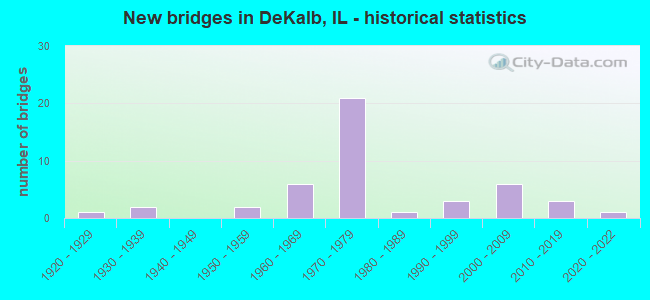
- New bridges - historical statistics
- 11920-1929
- 21930-1939
- 21950-1959
- 61960-1969
- 211970-1979
- 11980-1989
- 31990-1999
- 62000-2009
- 32010-2019
- 12020-2022
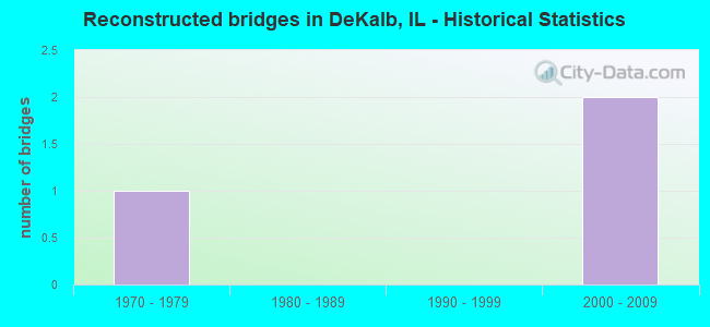
- Reconstructed bridges - Historical Statistics
- 11970-1979
- 01980-1989
- 01990-1999
- 22000-2009
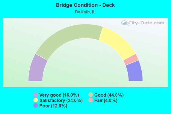
- Bridge Condition - Deck
- 16.0%Very good
- 44.0%Good
- 24.0%Satisfactory
- 4.0%Fair
- 12.0%Poor
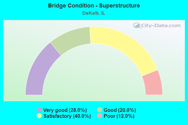
- Bridge Condition - Superstructure
- 28.0%Very good
- 20.0%Good
- 40.0%Satisfactory
- 12.0%Poor

- Bridge Condition - Substructure
- 24.0%Very good
- 28.0%Good
- 36.0%Satisfactory
- 12.0%Fair
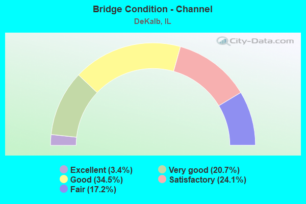
- Bridge Condition - Channel
- 3.4%Excellent
- 20.7%Very good
- 34.5%Good
- 24.1%Satisfactory
- 17.2%Fair
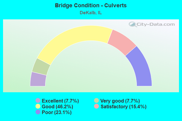
- Bridge Condition - Culverts
- 7.7%Excellent
- 7.7%Very good
- 46.2%Good
- 15.4%Satisfactory
- 23.1%Poor
Find on map >> Show street view
Structure Number: 199912, Location: S EDGE DEKALB (Lat: 41.902569, Lng: -88.753500), Route carried "under" structure: State highway 23, Year Built: 1974, Structure Length: 0. m, Average Daily Traffic: 4,800 (year 2021), Truck Traffic: 4%, Features Intersected: ILL 23, Facility Carried by Structure: I-88 EB
Minimum Vertical Clearance: 5.82m (19.09ft), Kilometerpoint: 134.457, Lanes on structure: 2, Lanes under structure: 2, Toll: On toll road, Material/Design: Prestressed concrete, Design/Construction: Stringer/Multi-beam, Length of Maximum Span: 13.4m (44.0ft)
Find on map >> Show street view
Structure Number: 199915, Location: SE EDGE OF DEKALB (Lat: 41.900311, Lng: -88.723981), Route carried "under" structure: Interstate 88, Year Built: 1974, Structure Length: 0. m, Average Daily Traffic: 23,200 (year 2020), Truck Traffic: 13%, Features Intersected: I-88, Facility Carried by Structure: FAP 324 - PEACE RD
Minimum Vertical Clearance: 4.93m (16.17ft), Kilometerpoint: 151.129, Lanes on structure: 2, Lanes under structure: 4, Material/Design: Prestressed concrete, Design/Construction: Stringer/Multi-beam, Length of Maximum Span: 26.5m (86.9ft)
Find on map >> Show street view
Structure Number: 19992, Location: .5 MI. E OF ILL 23 (Lat: 41.901628, Lng: -88.741542), Route carried "under" structure: Interstate 88, Year Built: 1974, Structure Length: 0. m, Average Daily Traffic: 18,100 (year 2020), Truck Traffic: 32%, Features Intersected: I-88 E-W TOLLWAY
Minimum Vertical Clearance: 4.93m (16.17ft), Kilometerpoint: 149.649, Lanes on structure: 2, Lanes under structure: 4, Toll: On toll road, Material/Design: Prestressed concrete, Design/Construction: Stringer/Multi-beam, Length of Maximum Span: 27.7m (90.9ft)
Find on map >> Show street view
Structure Number: 199921, Location: 0.1 MI S IL38/DEKALB (Lat: 41.929692, Lng: -88.758353), Route carried "under" structure: Other road , Year Built: 1966, Structure Length: 0. m, Average Daily Traffic: 1,800 (year 2021), Truck Traffic: 4%, Features Intersected: PEARL ST, Facility Carried by Structure: UNION PACIFIC RR
Minimum Vertical Clearance: 3.66m (12.01ft), Kilometerpoint: 0.129, Lanes under structure: 2, Material/Design: Steel, Design/Construction: Stringer/Multi-beam, Length of Maximum Span: 10.8m (35.4ft)