Bridge Statistics for Davie, Florida (FL)
Condition, Traffic, Stress, Structural Evaluation, Project Costs
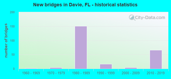
- New bridges - historical statistics
- 21960-1969
- 51970-1979
- 1511980-1989
- 171990-1999
- 52000-2009
- 662010-2019
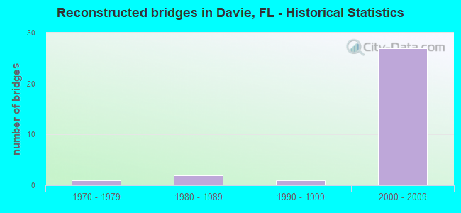
- Reconstructed bridges - Historical Statistics
- 11970-1979
- 21980-1989
- 11990-1999
- 272000-2009
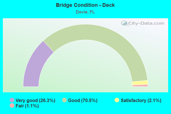
- Bridge Condition - Deck
- 26.3%Very good
- 70.5%Good
- 2.1%Satisfactory
- 1.1%Fair
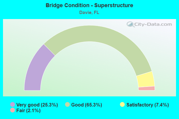
- Bridge Condition - Superstructure
- 25.3%Very good
- 65.3%Good
- 7.4%Satisfactory
- 2.1%Fair
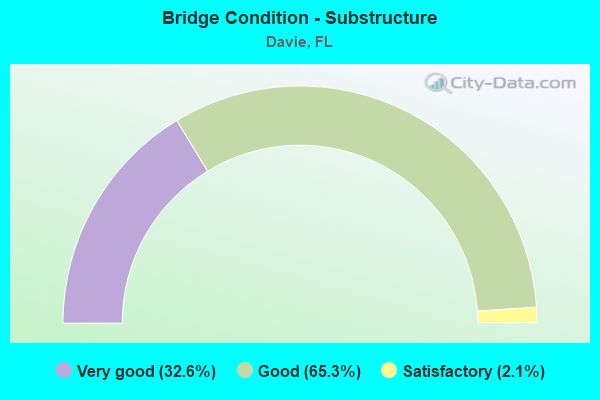
- Bridge Condition - Substructure
- 32.6%Very good
- 65.3%Good
- 2.1%Satisfactory
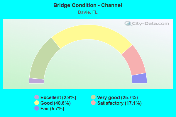
- Bridge Condition - Channel
- 2.9%Excellent
- 25.7%Very good
- 48.6%Good
- 17.1%Satisfactory
- 5.7%Fair
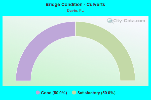
- Bridge Condition - Culverts
- 50.0%Good
- 50.0%Satisfactory
Find on map >> Show street view
Structure Number: 860417, Location: SR-7 & I-595 Interchange (Lat: 26.085056, Lng: -80.205111), Route carried "under" structure: Ramp Interstate 595, Year Built: 1988, Structure Length: 0. m, Average Daily Traffic: 7,000 (year 2018), Truck Traffic: 5%, Features Intersected: Ramp SB SR-7 & EB SR-84
Minimum Vertical Clearance: 4.88m (16.01ft), Kilometerpoint: 0.591, Lanes on structure: 2, Lanes under structure: 1, Material/Design: Prestressed concrete, Design/Construction: Stringer/Multi-beam, Length of Maximum Span: 28.5m (93.5ft)
Find on map >> Show street view
Structure Number: 860418, Location: US-441 & I-595 interchg (Lat: 26.085028, Lng: -80.202889), Route carried "under" structure: US 441, Year Built: 1988, Structure Length: 0. m, Average Daily Traffic: 53,500 (year 2020), Truck Traffic: 6%, Features Intersected: US-441 (SR-7), Facility Carried by Structure: I-595 (SR-862) EB
Minimum Vertical Clearance: 5.09m (16.70ft), Kilometerpoint: 12.521, Lanes on structure: 7, Lanes under structure: 7, Material/Design: Prestressed concrete, Design/Construction: Stringer/Multi-beam, Length of Maximum Span: 30.6m (100.4ft)
Find on map >> Show street view
Structure Number: 860419, Location: US-441 & I-595 Interchg (Lat: 26.085333, Lng: -80.202750), Route carried "under" structure: US 441, Year Built: 1988, Structure Length: 0. m, Average Daily Traffic: 56,000 (year 2020), Truck Traffic: 11%, Features Intersected: US-441 (SR-7), Facility Carried by Structure: I-595 (SR-862) WB
Minimum Vertical Clearance: 5.09m (16.70ft), Kilometerpoint: 12.550, Lanes on structure: 6, Lanes under structure: 7, Material/Design: Prestressed concrete, Design/Construction: Stringer/Multi-beam, Length of Maximum Span: 30.7m (100.7ft)
Find on map >> Show street view
Structure Number: 86042, Location: I-595 & SR-7 INTERCHANGE (Lat: 26.085908, Lng: -80.202614), Route carried "under" structure: US 441, Year Built: 1988, Structure Length: 0. m, Average Daily Traffic: 56,000 (year 2020), Truck Traffic: 11%, Features Intersected: US 441-SR 7, Facility Carried by Structure: I595 WB
Minimum Vertical Clearance: 5.30m (17.39ft), Kilometerpoint: 12.619, Lanes on structure: 3, Lanes under structure: 7, Material/Design: Prestressed concrete, Design/Construction: Stringer/Multi-beam, Length of Maximum Span: 31.4m (103.0ft)
Find on map >> Show street view
Structure Number: 860421, Location: 0.25 mi. East of SR-7 (Lat: 26.083056, Lng: -80.198306), Route carried "under" structure: Ramp State highway 84, Year Built: 1988, Structure Length: 0. m, Average Daily Traffic: 3,800 (year 2020), Truck Traffic: 8%, Features Intersected: SR-7 Ramp to SR-84, Facility Carried by Structure: SB US-441/EB I-595
Minimum Vertical Clearance: 5.09m (16.70ft), Kilometerpoint: 0.341, Lanes on structure: 3, Lanes under structure: 1, Material/Design: Prestressed concrete, Design/Construction: Stringer/Multi-beam, Length of Maximum Span: 35.2m (115.5ft)
Find on map >> Show street view
Structure Number: 860422, Location: SR-7 & I-595 Interchange (Lat: 26.084622, Lng: -80.202986), Route carried "under" structure: US 441, Year Built: 1988, Structure Length: 0. m, Average Daily Traffic: 53,500 (year 2020), Truck Traffic: 6%, Features Intersected: SR-7 US-441, Facility Carried by Structure: Tpk to I-595/SR-84
Minimum Vertical Clearance: 5.03m (16.50ft), Kilometerpoint: 12.476, Lanes on structure: 2, Lanes under structure: 7, Material/Design: Prestressed concrete, Design/Construction: Stringer/Multi-beam, Length of Maximum Span: 30.5m (100.1ft)
Find on map >> Show street view
Structure Number: 860425, Location: I-595 and SR-84 (Lat: 26.083739, Lng: -80.197333), Route carried "under" structure: Ramp US 595, Year Built: 1988, Structure Length: 0. m, Average Daily Traffic: 3,800 (year 2020), Truck Traffic: 8%, Features Intersected: EB SR-84
Minimum Vertical Clearance: 5.64m (18.50ft), Kilometerpoint: 0.470, Lanes on structure: 5, Lanes under structure: 1, Material/Design: Prestressed concrete, Design/Construction: Stringer/Multi-beam, Length of Maximum Span: 41.4m (135.8ft)
Find on map >> Show street view
Structure Number: 860425, Location: I-595 and SR-84 (Lat: 26.083739, Lng: -80.197333), Route carried "under" structure: State highway 84, Year Built: 1988, Structure Length: 0. m, Average Daily Traffic: 8,500 (year 2018), Truck Traffic: 6%, Features Intersected: EB SR-84, Facility Carried by Structure: I-595 EB (SR-862)
Minimum Vertical Clearance: 5.15m (16.90ft), Kilometerpoint: 0.966, Lanes on structure: 5, Lanes under structure: 2, Material/Design: Prestressed concrete, Design/Construction: Stringer/Multi-beam, Length of Maximum Span: 41.4m (135.8ft)
Find on map >> Show street view
Structure Number: 860426, Location: I-595 and SR-84 (Lat: 26.084028, Lng: -80.196556), Route carried "under" structure: State highway 84, Year Built: 1988, Structure Length: 0. m, Average Daily Traffic: 7,800 (year 2020), Truck Traffic: 4%, Features Intersected: EB SR-84, Facility Carried by Structure: I-595 WB (SR-862)
Minimum Vertical Clearance: 5.09m (16.70ft), Kilometerpoint: 23.305, Lanes on structure: 4, Lanes under structure: 2, Material/Design: Steel continuous, Design/Construction: Stringer/Multi-beam, Length of Maximum Span: 53.8m (176.5ft)
Find on map >> Show street view
Structure Number: 860432, Location: 3.8 MI NORTH OF SR-820 (Lat: 26.065689, Lng: -80.215425), Route carried "under" structure: State highway 818, Year Built: 1986, Structure Length: 0. m, Average Daily Traffic: 35,000 (year 2021), Truck Traffic: 6%, Features Intersected: SR 818 & NEW RIVER CANAL, Facility Carried by Structure: SR91 TPK 53.95
Minimum Vertical Clearance: 5.33m (17.49ft), Kilometerpoint: 9.812, Lanes on structure: 7, Lanes under structure: 10, Material/Design: Prestressed concrete, Design/Construction: Stringer/Multi-beam, Length of Maximum Span: 26.4m (86.6ft)
Find on map >> Show street view
Structure Number: 860432, Location: 3.8 MI NORTH OF SR-820 (Lat: 26.065689, Lng: -80.215425), Route carried "under" structure: Business City street , Year Built: 1986, Structure Length: 0. m, Average Daily Traffic: 3,500 (year 2021), Truck Traffic: 5%, Features Intersected: SR 818 & NEW RIVER CANAL, Facility Carried by Structure: SR91 TPK 53.95
Minimum Vertical Clearance: 5.21m (17.09ft), Kilometerpoint: 9.812, Lanes on structure: 7, Lanes under structure: 4, Material/Design: Prestressed concrete, Design/Construction: Stringer/Multi-beam, Length of Maximum Span: 26.4m (86.6ft)
Find on map >> Show street view
Structure Number: 860433, Location: 0.2mi W of US-441 (Lat: 26.046267, Lng: -80.215131), Route carried "under" structure: State highway 91, Year Built: 1983, Structure Length: 0. m, Average Daily Traffic: 13,000 (year 2020), Truck Traffic: 11%, Features Intersected: Fl. Tpk. (SR-91), Facility Carried by Structure: EB Stirling Rd.
Minimum Vertical Clearance: 5.06m (16.60ft), Kilometerpoint: 8.702, Lanes on structure: 3, Lanes under structure: 6, Toll: On toll road, Material/Design: Prestressed concrete, Design/Construction: Stringer/Multi-beam, Length of Maximum Span: 23.8m (78.1ft)
Find on map >> Show street view
Structure Number: 860433, Location: 0.2mi W of US-441 (Lat: 26.046267, Lng: -80.215131), Route carried "under" structure: ServiceCity street , Year Built: 1983, Structure Length: 0. m, Average Daily Traffic: 300 (year 2017), Truck Traffic: 5%, Features Intersected: Fl. Tpk. (SR-91), Facility Carried by Structure: EB Stirling Rd.
Minimum Vertical Clearance: 5.06m (16.60ft), Kilometerpoint: 0.000, Lanes on structure: 3, Lanes under structure: 2, Material/Design: Prestressed concrete, Design/Construction: Stringer/Multi-beam, Length of Maximum Span: 23.8m (78.1ft)
Find on map >> Show street view
Structure Number: 860468, Location: I595 - SR-7 Interchange (Lat: 26.085117, Lng: -80.199583), Route carried "under" structure: Ramp State highway 84, Year Built: 1988, Structure Length: 0. m, Average Daily Traffic: 2,100 (year 2020), Truck Traffic: 7%, Features Intersected: SR 84 EXIT RAMP TO SR 7, Facility Carried by Structure: I595WB RMP to TPK
Minimum Vertical Clearance: 5.12m (16.80ft), Kilometerpoint: 0.222, Lanes on structure: 2, Lanes under structure: 1, Material/Design: Steel continuous, Design/Construction: Stringer/Multi-beam, Length of Maximum Span: 47.6m (156.2ft)
Find on map >> Show street view
Structure Number: 860469, Location: I-595 / SR-7 Interchange (Lat: 26.084289, Lng: -80.196039), Route carried "under" structure: Ramp Interstate 595, Year Built: 1988, Structure Length: 0. m, Average Daily Traffic: 10,250 (year 2020), Truck Traffic: 7%, Features Intersected: I-595 Ramps
Minimum Vertical Clearance: 5.24m (17.19ft), Kilometerpoint: 0.188, Lanes on structure: 2, Lanes under structure: 2, Material/Design: Steel continuous, Design/Construction: Stringer/Multi-beam, Length of Maximum Span: 69.5m (228.0ft)
Find on map >> Show street view
Structure Number: 860469, Location: I-595 / SR-7 Interchange (Lat: 26.084289, Lng: -80.196039), Route carried "under" structure: Ramp Interstate 595, Year Built: 1988, Structure Length: 0. m, Average Daily Traffic: 7,600 (year 2019), Truck Traffic: 8%, Features Intersected: I-595 Ramps
Minimum Vertical Clearance: 5.09m (16.70ft), Kilometerpoint: 1.159, Lanes on structure: 2, Lanes under structure: 2, Material/Design: Steel continuous, Design/Construction: Stringer/Multi-beam, Length of Maximum Span: 69.5m (228.0ft)
Find on map >> Show street view
Structure Number: 860475, Location: I-595 & SR-7 INTERCHANGE (Lat: 26.087200, Lng: -80.205083), Route carried "under" structure: Ramp Interstate , Year Built: 1988, Structure Length: 0. m, Average Daily Traffic: 3,000 (year 2020), Truck Traffic: 6%, Features Intersected: SR 7 SB RAMP TO SR 84 WB, Facility Carried by Structure: WB SR-84
Minimum Vertical Clearance: 5.18m (16.99ft), Kilometerpoint: 0.475, Lanes on structure: 3, Lanes under structure: 1, Material/Design: Prestressed concrete, Design/Construction: Stringer/Multi-beam, Length of Maximum Span: 26.2m (86.0ft)
Find on map >> Show street view
Structure Number: 860476, Location: I-595 / US441 Interchange (Lat: 26.085692, Lng: -80.203231), Route carried "under" structure: Interstate 595, Year Built: 1988, Structure Length: 0. m, Average Daily Traffic: 97,250 (year 2020), Truck Traffic: 6%, Features Intersected: SR-869 & EB to NB ramp
Minimum Vertical Clearance: 5.21m (17.09ft), Kilometerpoint: 13.287, Lanes on structure: 2, Lanes under structure: 13, Material/Design: Prestressed concrete continuous, Design/Construction: Segmental Box Girder, Length of Maximum Span: 68.2m (223.8ft)
Find on map >> Show street view
Structure Number: 860476, Location: I-595 / US441 Interchange (Lat: 26.085692, Lng: -80.203231), Route carried "under" structure: Ramp Interstate 595, Year Built: 1988, Structure Length: 0. m, Average Daily Traffic: 3,000 (year 2020), Truck Traffic: 6%, Features Intersected: SR-869 & EB to NB ramp
Minimum Vertical Clearance: 5.24m (17.19ft), Kilometerpoint: 0.539, Lanes on structure: 2, Lanes under structure: 1, Material/Design: Prestressed concrete continuous, Design/Construction: Segmental Box Girder, Length of Maximum Span: 68.2m (223.8ft)
Find on map >> Show street view
Structure Number: 860476, Location: I-595 / US441 Interchange (Lat: 26.085692, Lng: -80.203231), Route carried "under" structure: Ramp Interstate 595, Year Built: 1988, Structure Length: 0. m, Average Daily Traffic: 5,200 (year 2020), Truck Traffic: 8%, Features Intersected: SR-869 & EB to NB ramp
Minimum Vertical Clearance: 6.40m (21.00ft), Kilometerpoint: 0.673, Lanes on structure: 2, Lanes under structure: 1, Material/Design: Prestressed concrete continuous, Design/Construction: Segmental Box Girder, Length of Maximum Span: 68.2m (223.8ft)
Find on map >> Show street view
Structure Number: 860476, Location: I-595 / US441 Interchange (Lat: 26.085692, Lng: -80.203231), Route carried "under" structure: Ramp Interstate 595, Year Built: 1988, Structure Length: 0. m, Average Daily Traffic: 6,400 (year 2020), Truck Traffic: 6%, Features Intersected: SR-869 & EB to NB ramp
Minimum Vertical Clearance: 5.58m (18.31ft), Kilometerpoint: 0.388, Lanes on structure: 2, Lanes under structure: 2, Material/Design: Prestressed concrete continuous, Design/Construction: Segmental Box Girder, Length of Maximum Span: 68.2m (223.8ft)
Find on map >> Show street view
Structure Number: 860476, Location: I-595 / US441 Interchange (Lat: 26.085692, Lng: -80.203231), Route carried "under" structure: State highway 84, Year Built: 1988, Structure Length: 0. m, Average Daily Traffic: 7,800 (year 2020), Truck Traffic: 4%, Features Intersected: SR-869 & EB to NB ramp, Facility Carried by Structure: NBUS441 to WBI-595
Minimum Vertical Clearance: 5.09m (16.70ft), Kilometerpoint: 22.714, Lanes on structure: 2, Lanes under structure: 2, Material/Design: Prestressed concrete continuous, Design/Construction: Segmental Box Girder, Length of Maximum Span: 68.2m (223.8ft)
Find on map >> Show street view
Structure Number: 860477, Location: I-595 / SR-7 Interchange (Lat: 26.085778, Lng: -80.202353), Route carried "under" structure: Ramp Interstate 595, Year Built: 1988, Structure Length: 0. m, Average Daily Traffic: 12,000 (year 2020), Truck Traffic: 6%, Features Intersected: I-595, SR-7 & Connectors
Minimum Vertical Clearance: 5.06m (16.60ft), Kilometerpoint: 0.729, Lanes on structure: 2, Lanes under structure: 2, Material/Design: Prestressed concrete continuous, Design/Construction: Segmental Box Girder, Length of Maximum Span: 68.2m (223.8ft)
Find on map >> Show street view
Structure Number: 860477, Location: I-595 / SR-7 Interchange (Lat: 26.085778, Lng: -80.202353), Route carried "under" structure: State highway 84, Year Built: 1988, Structure Length: 0. m, Average Daily Traffic: 7,800 (year 2020), Truck Traffic: 4%, Features Intersected: I-595, SR-7 & Connectors, Facility Carried by Structure: I-595 EB to SR7 NB
Minimum Vertical Clearance: 8.84m (29.00ft), Kilometerpoint: 22.006, Lanes on structure: 2, Lanes under structure: 2, Material/Design: Prestressed concrete continuous, Design/Construction: Segmental Box Girder, Length of Maximum Span: 68.2m (223.8ft)
Find on map >> Show street view
Structure Number: 860477, Location: I-595 / SR-7 Interchange (Lat: 26.085778, Lng: -80.202353), Route carried "under" structure: Ramp Interstate 595, Year Built: 1988, Structure Length: 0. m, Average Daily Traffic: 2,100 (year 2020), Truck Traffic: 9%, Features Intersected: I-595, SR-7 & Connectors
Minimum Vertical Clearance: 13.11m (43.01ft), Kilometerpoint: 0.546, Lanes on structure: 2, Lanes under structure: 3, Material/Design: Prestressed concrete continuous, Design/Construction: Segmental Box Girder, Length of Maximum Span: 68.2m (223.8ft)
Find on map >> Show street view
Structure Number: 860477, Location: I-595 / SR-7 Interchange (Lat: 26.085778, Lng: -80.202353), Route carried "under" structure: Ramp Interstate 595, Year Built: 1988, Structure Length: 0. m, Average Daily Traffic: 8,800 (year 2020), Truck Traffic: 6%, Features Intersected: I-595, SR-7 & Connectors
Minimum Vertical Clearance: 12.77m (41.90ft), Kilometerpoint: 0.497, Lanes on structure: 2, Lanes under structure: 2, Material/Design: Prestressed concrete continuous, Design/Construction: Segmental Box Girder, Length of Maximum Span: 68.2m (223.8ft)
Find on map >> Show street view
Structure Number: 860477, Location: I-595 / SR-7 Interchange (Lat: 26.085778, Lng: -80.202353), Route carried "under" structure: Ramp Interstate 595, Year Built: 1988, Structure Length: 0. m, Average Daily Traffic: 6,700 (year 2020), Truck Traffic: 8%, Features Intersected: I-595, SR-7 & Connectors
Minimum Vertical Clearance: 16.76m (54.99ft), Kilometerpoint: 0.760, Lanes on structure: 2, Lanes under structure: 1, Material/Design: Prestressed concrete continuous, Design/Construction: Segmental Box Girder, Length of Maximum Span: 68.2m (223.8ft)
Find on map >> Show street view
Structure Number: 860477, Location: I-595 / SR-7 Interchange (Lat: 26.085778, Lng: -80.202353), Route carried "under" structure: Ramp Interstate 595, Year Built: 1988, Structure Length: 0. m, Average Daily Traffic: 8,200 (year 2020), Truck Traffic: 5%, Features Intersected: I-595, SR-7 & Connectors
Minimum Vertical Clearance: 6.89m (22.60ft), Kilometerpoint: 0.563, Lanes on structure: 2, Lanes under structure: 1, Material/Design: Prestressed concrete continuous, Design/Construction: Segmental Box Girder, Length of Maximum Span: 68.2m (223.8ft)
Find on map >> Show street view
Structure Number: 860507, Location: .2 mi W of US-441 (Lat: 26.046572, Lng: -80.214328), Route carried "under" structure: State highway 91, Year Built: 1983, Structure Length: 0. m, Average Daily Traffic: 13,000 (year 2020), Truck Traffic: 11%, Features Intersected: Fl Tpk. (SR-91), Facility Carried by Structure: WB Stirling Rd.
Minimum Vertical Clearance: 5.03m (16.50ft), Kilometerpoint: 8.719, Lanes on structure: 3, Lanes under structure: 6, Toll: On toll road, Material/Design: Prestressed concrete, Design/Construction: Stringer/Multi-beam, Length of Maximum Span: 23.8m (78.1ft)
Find on map >> Show street view
Structure Number: 860507, Location: .2 mi W of US-441 (Lat: 26.046572, Lng: -80.214328), Route carried "under" structure: ServiceCity street , Year Built: 1983, Structure Length: 0. m, Average Daily Traffic: 300 (year 2017), Truck Traffic: 5%, Features Intersected: Fl Tpk. (SR-91), Facility Carried by Structure: WB Stirling Rd.
Minimum Vertical Clearance: 5.82m (19.09ft), Kilometerpoint: 0.000, Lanes on structure: 3, Lanes under structure: 2, Material/Design: Prestressed concrete, Design/Construction: Stringer/Multi-beam, Length of Maximum Span: 23.8m (78.1ft)
Find on map >> Show street view
Structure Number: 86051, Location: I-75/SR869/I-595 Interchg (Lat: 26.122128, Lng: -80.342917), Route carried "under" structure: State highway 84, Year Built: 1988, Structure Length: 0. m, Average Daily Traffic: 8,200 (year 2020), Truck Traffic: 4%, Features Intersected: WB SR84 & New River Cnl, Facility Carried by Structure: WB 595 TO NB SR869
Minimum Vertical Clearance: 5.39m (17.68ft), Kilometerpoint: 11.996, Lanes on structure: 2, Lanes under structure: 2, Material/Design: Prestressed concrete continuous, Design/Construction: Segmental Box Girder, Length of Maximum Span: 55.5m (182.1ft)
Find on map >> Show street view
Structure Number: 860519, Location: I-75/I-595 INTERCHANGE (Lat: 26.122822, Lng: -80.343950), Route carried "under" structure: State highway 84, Year Built: 1988, Structure Length: 0. m, Average Daily Traffic: 8,200 (year 2020), Truck Traffic: 4%, Features Intersected: SR-84 WB and New River, Facility Carried by Structure: NB I-75 to NB 869
Minimum Vertical Clearance: 5.09m (16.70ft), Kilometerpoint: 12.146, Lanes on structure: 3, Lanes under structure: 2, Material/Design: Prestressed concrete continuous, Design/Construction: Segmental Box Girder, Length of Maximum Span: 42.8m (140.4ft)
Find on map >> Show street view
Structure Number: 860533, Location: 5.6 MILES NORTH OF SR-820 (Lat: 26.091231, Lng: -80.216647), Route carried "under" structure: Interstate 595, Year Built: 1988, Structure Length: 0. m, Average Daily Traffic: 7,108 (year 2021), Truck Traffic: 4%, Features Intersected: I-595 (SR-862) & CANAL, Facility Carried by Structure: SR-91 TPK 55.67
Minimum Vertical Clearance: 5.15m (16.90ft), Kilometerpoint: 13.123, Lanes on structure: 10, Lanes under structure: 16, Material/Design: Prestressed concrete, Design/Construction: Stringer/Multi-beam, Length of Maximum Span: 46.2m (151.6ft)
Find on map >> Show street view
Structure Number: 860559, Location: SR-91-I-595 INTERCHANGE (Lat: 26.082917, Lng: -80.216467), Route carried "under" structure: Ramp State highway 91, Year Built: 1989, Structure Length: 0. m, Average Daily Traffic: 26,500 (year 2019), Truck Traffic: 12%, Features Intersected: SR-91 & RAMPS
Minimum Vertical Clearance: 6.10m (20.01ft), Kilometerpoint: 0.098, Lanes on structure: 2, Lanes under structure: 3, Toll: On toll road, Material/Design: Prestressed concrete, Design/Construction: Stringer/Multi-beam, Length of Maximum Span: 27.7m (90.9ft)
Find on map >> Show street view
Structure Number: 860559, Location: SR-91-I-595 INTERCHANGE (Lat: 26.082917, Lng: -80.216467), Route carried "under" structure: Ramp State highway 91, Year Built: 1989, Structure Length: 0. m, Average Daily Traffic: 26,500 (year 2019), Truck Traffic: 12%, Features Intersected: SR-91 & RAMPS
Minimum Vertical Clearance: 5.52m (18.11ft), Kilometerpoint: 2.531, Lanes on structure: 2, Lanes under structure: 3, Toll: On toll road, Material/Design: Prestressed concrete, Design/Construction: Stringer/Multi-beam, Length of Maximum Span: 27.7m (90.9ft)
Find on map >> Show street view
Structure Number: 860559, Location: SR-91-I-595 INTERCHANGE (Lat: 26.082917, Lng: -80.216467), Route carried "under" structure: State highway 91, Year Built: 1989, Structure Length: 0. m, Average Daily Traffic: 130,100 (year 2020), Truck Traffic: 13%, Features Intersected: SR-91 & RAMPS
Minimum Vertical Clearance: 10.97m (35.99ft), Kilometerpoint: 12.775, Lanes on structure: 2, Lanes under structure: 10, Toll: On toll road, Material/Design: Prestressed concrete, Design/Construction: Stringer/Multi-beam, Length of Maximum Span: 27.7m (90.9ft)
Find on map >> Show street view
Structure Number: 860559, Location: SR-91-I-595 INTERCHANGE (Lat: 26.082917, Lng: -80.216467), Route carried "under" structure: Ramp State highway 91, Year Built: 1989, Structure Length: 0. m, Average Daily Traffic: 23,000 (year 2020), Truck Traffic: 10%, Features Intersected: SR-91 & RAMPS
Minimum Vertical Clearance: 12.50m (41.01ft), Kilometerpoint: 0.000, Lanes on structure: 2, Lanes under structure: 1, Toll: On toll road, Material/Design: Prestressed concrete, Design/Construction: Stringer/Multi-beam, Length of Maximum Span: 27.7m (90.9ft)
Find on map >> Show street view
Structure Number: 860561, Location: I-595-SR-91 INTERCHANGE (Lat: 26.089744, Lng: -80.212667), Route carried "under" structure: Ramp State highway 91, Year Built: 1990, Structure Length: 0. m, Average Daily Traffic: 18,500 (year 2020), Truck Traffic: 13%, Features Intersected: I-595-SR-91 ENT RAMP
Minimum Vertical Clearance: 5.27m (17.29ft), Kilometerpoint: 0.558, Lanes on structure: 2, Lanes under structure: 2, Toll: On toll road, Material/Design: Steel continuous, Design/Construction: Box Beam or Girders - Single/Spread, Length of Maximum Span: 55.2m (181.1ft)
Find on map >> Show street view
Structure Number: 860561, Location: I-595-SR-91 INTERCHANGE (Lat: 26.089744, Lng: -80.212667), Route carried "under" structure: Interstate 595, Year Built: 1990, Structure Length: 0. m, Average Daily Traffic: 97,250 (year 2020), Truck Traffic: 6%, Features Intersected: I-595-SR-91 ENT RAMP, Facility Carried by Structure: SR91 WB TPK 55.2
Minimum Vertical Clearance: 10.97m (35.99ft), Kilometerpoint: 12.192, Lanes on structure: 2, Lanes under structure: 7, Material/Design: Steel continuous, Design/Construction: Box Beam or Girders - Single/Spread, Length of Maximum Span: 55.2m (181.1ft)
Find on map >> Show street view
Structure Number: 860561, Location: I-595-SR-91 INTERCHANGE (Lat: 26.089744, Lng: -80.212667), Route carried "under" structure: Interstate 595, Year Built: 1990, Structure Length: 0. m, Average Daily Traffic: 4,900 (year 2020), Truck Traffic: 6%, Features Intersected: I-595-SR-91 ENT RAMP, Facility Carried by Structure: SR91 WB TPK 55.2
Minimum Vertical Clearance: 10.97m (35.99ft), Kilometerpoint: 13.560, Lanes on structure: 2, Lanes under structure: 2, Toll: On toll road, Material/Design: Steel continuous, Design/Construction: Box Beam or Girders - Single/Spread, Length of Maximum Span: 55.2m (181.1ft)
Find on map >> Show street view
Structure Number: 860561, Location: I-595-SR-91 INTERCHANGE (Lat: 26.089744, Lng: -80.212667), Route carried "under" structure: Ramp State highway 84, Year Built: 1990, Structure Length: 0. m, Average Daily Traffic: 18,000 (year 2020), Truck Traffic: 3%, Features Intersected: I-595-SR-91 ENT RAMP, Facility Carried by Structure: SR91 WB TPK 55.2
Minimum Vertical Clearance: 7.04m (23.10ft), Kilometerpoint: 0.060, Lanes on structure: 2, Lanes under structure: 2, Toll: On toll road, Material/Design: Steel continuous, Design/Construction: Box Beam or Girders - Single/Spread, Length of Maximum Span: 55.2m (181.1ft)
Find on map >> Show street view
Structure Number: 860563, Location: SR-91/I-595 INTERCHANGE (Lat: 26.089681, Lng: -80.212294), Route carried "under" structure: State highway 84, Year Built: 1990, Structure Length: 0. m, Average Daily Traffic: 49,000 (year 2020), Truck Traffic: 8%, Features Intersected: I-595, Facility Carried by Structure: I595 WB 55.343
Minimum Vertical Clearance: 5.00m (16.40ft), Kilometerpoint: 21.501, Lanes on structure: 2, Lanes under structure: 2, Material/Design: Steel continuous, Design/Construction: Box Beam or Girders - Single/Spread, Length of Maximum Span: 49.8m (163.4ft)
Find on map >> Show street view
Structure Number: 860563, Location: SR-91/I-595 INTERCHANGE (Lat: 26.089681, Lng: -80.212294), Route carried "under" structure: Interstate 595, Year Built: 1990, Structure Length: 0. m, Average Daily Traffic: 4,900 (year 2020), Truck Traffic: 6%, Features Intersected: I-595
Minimum Vertical Clearance: 5.03m (16.50ft), Kilometerpoint: 13.560, Lanes on structure: 2, Lanes under structure: 2, Toll: On toll road, Material/Design: Steel continuous, Design/Construction: Box Beam or Girders - Single/Spread, Length of Maximum Span: 49.8m (163.4ft)
Find on map >> Show street view
Structure Number: 860563, Location: SR-91/I-595 INTERCHANGE (Lat: 26.089681, Lng: -80.212294), Route carried "under" structure: Interstate 595, Year Built: 1990, Structure Length: 0. m, Average Daily Traffic: 194,500 (year 2020), Truck Traffic: 5%, Features Intersected: I-595
Minimum Vertical Clearance: 5.02m (16.47ft), Kilometerpoint: 12.228, Lanes on structure: 2, Lanes under structure: 7, Material/Design: Steel continuous, Design/Construction: Box Beam or Girders - Single/Spread, Length of Maximum Span: 49.8m (163.4ft)
Find on map >> Show street view
Structure Number: 860573, Location: I-595 & SR-817 Interchang (Lat: 26.096861, Lng: -80.250667), Route carried "under" structure: Business City street , Year Built: 1989, Structure Length: 0. m, Average Daily Traffic: 250 (year 2003), Truck Traffic: 5%, Features Intersected: Plaza Drive, Facility Carried by Structure: NB SR-817/WB I-595
Minimum Vertical Clearance: 4.42m (14.50ft), Kilometerpoint: 0.000, Lanes on structure: 1, Lanes under structure: 6, Material/Design: Prestressed concrete, Design/Construction: Stringer/Multi-beam, Length of Maximum Span: 20.7m (67.9ft)
Find on map >> Show street view
Structure Number: 860645, Location: Pine Island Rd. & SR84 WB (Lat: 26.103547, Lng: -80.266711), Route carried "under" structure: State highway 84, Year Built: 2010, Structure Length: 0. m, Average Daily Traffic: 22,000 (year 2018), Truck Traffic: 5%, Features Intersected: WB SR-84
Minimum Vertical Clearance: 5.46m (17.91ft), Kilometerpoint: 4.009, Lanes on structure: 2, Lanes under structure: 2, Material/Design: Steel continuous, Design/Construction: Stringer/Multi-beam, Length of Maximum Span: 50.3m (165.0ft)
Find on map >> Show street view
Structure Number: 860648, Location: I-595 and Pine Island Rd. (Lat: 26.103058, Lng: -80.265428), Route carried "under" structure: Ramp State highway 84, Year Built: 2010, Structure Length: 0. m, Average Daily Traffic: 17,500 (year 2020), Truck Traffic: 3%, Features Intersected: Pine Island Road, Facility Carried by Structure: I-595 WB
Minimum Vertical Clearance: 5.39m (17.68ft), Kilometerpoint: 4.059, Lanes on structure: 5, Lanes under structure: 1, Material/Design: Steel continuous, Design/Construction: Stringer/Multi-beam, Length of Maximum Span: 47.2m (154.9ft)
Find on map >> Show street view
Structure Number: 860648, Location: I-595 and Pine Island Rd. (Lat: 26.103058, Lng: -80.265428), Route carried "under" structure: Ramp State highway 84, Year Built: 2010, Structure Length: 0. m, Average Daily Traffic: 7,000 (year 2020), Truck Traffic: 3%, Features Intersected: Pine Island Road, Facility Carried by Structure: I-595 WB
Minimum Vertical Clearance: 5.58m (18.31ft), Kilometerpoint: 15.994, Lanes on structure: 5, Lanes under structure: 1, Material/Design: Steel continuous, Design/Construction: Stringer/Multi-beam, Length of Maximum Span: 47.2m (154.9ft)
Find on map >> Show street view
Structure Number: 860648, Location: I-595 and Pine Island Rd. (Lat: 26.103058, Lng: -80.265428), Route carried "under" structure: County highway , Year Built: 2010, Structure Length: 0. m, Average Daily Traffic: 33,000 (year 2020), Truck Traffic: 4%, Features Intersected: Pine Island Road, Facility Carried by Structure: I-595 WB
Minimum Vertical Clearance: 5.52m (18.11ft), Kilometerpoint: 0.021, Lanes on structure: 5, Lanes under structure: 8, Material/Design: Steel continuous, Design/Construction: Stringer/Multi-beam, Length of Maximum Span: 47.2m (154.9ft)
Find on map >> Show street view
Structure Number: 860649, Location: 1Mi W of University Dr. (Lat: 26.102858, Lng: -80.265539), Route carried "under" structure: Ramp State highway 840, Year Built: 2010, Structure Length: 0. m, Average Daily Traffic: 49,998 (year 2013), Truck Traffic: 1%, Features Intersected: Pine Island Road, Facility Carried by Structure: I595 Express Lanes
Minimum Vertical Clearance: 4.97m (16.31ft), Kilometerpoint: 15.994, Lanes on structure: 3, Lanes under structure: 1, Material/Design: Steel continuous, Design/Construction: Stringer/Multi-beam, Length of Maximum Span: 48.2m (158.1ft)
Find on map >> Show street view
Structure Number: 860649, Location: 1Mi W of University Dr. (Lat: 26.102858, Lng: -80.265539), Route carried "under" structure: County highway , Year Built: 2010, Structure Length: 0. m, Average Daily Traffic: 49,998 (year 2013), Truck Traffic: 5%, Features Intersected: Pine Island Road, Facility Carried by Structure: I595 Express Lanes
Minimum Vertical Clearance: 4.91m (16.11ft), Kilometerpoint: 0.027, Lanes on structure: 3, Lanes under structure: 8, Material/Design: Steel continuous, Design/Construction: Stringer/Multi-beam, Length of Maximum Span: 48.2m (158.1ft)
Find on map >> Show street view
Structure Number: 860649, Location: 1Mi W of University Dr. (Lat: 26.102858, Lng: -80.265539), Route carried "under" structure: Ramp State highway 84, Year Built: 2010, Structure Length: 0. m, Average Daily Traffic: 200 (year 2013), Truck Traffic: 1%, Features Intersected: Pine Island Road, Facility Carried by Structure: I595 Express Lanes
Minimum Vertical Clearance: 4.97m (16.31ft), Kilometerpoint: 3.975, Lanes on structure: 3, Lanes under structure: 1, Material/Design: Steel continuous, Design/Construction: Stringer/Multi-beam, Length of Maximum Span: 48.2m (158.1ft)
Find on map >> Show street view
Structure Number: 86065, Location: 1Mi W of University Dr. (Lat: 26.102472, Lng: -80.265581), Route carried "under" structure: County highway , Year Built: 2011, Structure Length: 0. m, Average Daily Traffic: 27,560 (year 2020), Truck Traffic: 9%, Features Intersected: Pine Island Road, Facility Carried by Structure: EB I595 to EB SR84
Minimum Vertical Clearance: 5.46m (17.91ft), Kilometerpoint: 4.281, Lanes on structure: 1, Lanes under structure: 8, Material/Design: Steel continuous, Design/Construction: Stringer/Multi-beam, Length of Maximum Span: 48.2m (158.1ft)
Find on map >> Show street view
Structure Number: 86065, Location: 1Mi W of University Dr. (Lat: 26.102472, Lng: -80.265581), Route carried "under" structure: Ramp State highway 84, Year Built: 2011, Structure Length: 0. m, Average Daily Traffic: 2,400 (year 2020), Truck Traffic: 2%, Features Intersected: Pine Island Road
Minimum Vertical Clearance: 5.33m (17.49ft), Kilometerpoint: 15.971, Lanes on structure: 1, Lanes under structure: 1, Material/Design: Steel continuous, Design/Construction: Stringer/Multi-beam, Length of Maximum Span: 48.2m (158.1ft)
Find on map >> Show street view
Structure Number: 86065, Location: 1Mi W of University Dr. (Lat: 26.102472, Lng: -80.265581), Route carried "under" structure: Ramp State highway 84, Year Built: 2011, Structure Length: 0. m, Average Daily Traffic: 2,400 (year 2020), Truck Traffic: 3%, Features Intersected: Pine Island Road
Minimum Vertical Clearance: 5.23m (17.16ft), Kilometerpoint: 3.961, Lanes on structure: 1, Lanes under structure: 1, Material/Design: Steel continuous, Design/Construction: Stringer/Multi-beam, Length of Maximum Span: 48.2m (158.1ft)
Find on map >> Show street view
Structure Number: 860651, Location: 1.2Mi. W of University Dr (Lat: 26.104083, Lng: -80.271994), Route carried "under" structure: Ramp Interstate 595, Year Built: 2013, Structure Length: 0. m, Average Daily Traffic: 10,000 (year 2020), Truck Traffic: 7%, Features Intersected: SR84 EB to I595 EB
Minimum Vertical Clearance: 5.72m (18.77ft), Kilometerpoint: 0.000, Lanes on structure: 1, Lanes under structure: 1, Material/Design: Steel continuous, Design/Construction: Stringer/Multi-beam, Length of Maximum Span: 70.1m (230.0ft)
Find on map >> Show street view
Structure Number: 860652, Location: Direct Conn. E. of Davie (Lat: 26.091781, Lng: -80.220117), Route carried "under" structure: Interstate 595, Year Built: 2013, Structure Length: 0. m, Average Daily Traffic: 146,800 (year 2013), Truck Traffic: 4%, Features Intersected: I-595, Facility Carried by Structure: Express Lane Ramp
Minimum Vertical Clearance: 5.03m (16.50ft), Kilometerpoint: 0.000, Lanes on structure: 2, Lanes under structure: 2, Toll: On toll road, Material/Design: Steel continuous, Design/Construction: Box Beam or Girders - Single/Spread, Length of Maximum Span: 72.9m (239.2ft)
Find on map >> Show street view
Structure Number: 860653, Location: I595 Exp. ramp R-9 To TPK (Lat: 26.089211, Lng: -80.216425), Route carried "under" structure: Other road 91, Year Built: 2013, Structure Length: 0. m, Average Daily Traffic: 65,050 (year 2020), Truck Traffic: 13%, Features Intersected: TPK SB SR84 EB I595EB, Facility Carried by Structure: I-595 to TPK S Rmp
Minimum Vertical Clearance: 7.53m (24.70ft), Kilometerpoint: 13.490, Lanes on structure: 1, Lanes under structure: 5, Toll: On toll road, Material/Design: Steel continuous, Design/Construction: Box Beam or Girders - Single/Spread, Length of Maximum Span: 92.7m (304.1ft)
Find on map >> Show street view
Structure Number: 860653, Location: I595 Exp. ramp R-9 To TPK (Lat: 26.089211, Lng: -80.216425), Route carried "under" structure: State highway 84, Year Built: 2013, Structure Length: 0. m, Average Daily Traffic: 49,000 (year 2020), Truck Traffic: 8%, Features Intersected: TPK SB SR84 EB I595EB, Facility Carried by Structure: I-595 to TPK S Rmp
Minimum Vertical Clearance: 12.47m (40.91ft), Kilometerpoint: 20.981, Lanes on structure: 1, Lanes under structure: 3, Material/Design: Steel continuous, Design/Construction: Box Beam or Girders - Single/Spread, Length of Maximum Span: 92.7m (304.1ft)
Find on map >> Show street view
Structure Number: 860653, Location: I595 Exp. ramp R-9 To TPK (Lat: 26.089211, Lng: -80.216425), Route carried "under" structure: Interstate 595, Year Built: 2013, Structure Length: 0. m, Average Daily Traffic: 97,250 (year 2020), Truck Traffic: 6%, Features Intersected: TPK SB SR84 EB I595EB
Minimum Vertical Clearance: 9.88m (32.41ft), Kilometerpoint: 11.636, Lanes on structure: 1, Lanes under structure: 4, Material/Design: Steel continuous, Design/Construction: Box Beam or Girders - Single/Spread, Length of Maximum Span: 92.7m (304.1ft)
Find on map >> Show street view
Structure Number: 860654, Location: I595 Exp. Lane Conn. TPK (Lat: 26.092561, Lng: -80.216986), Route carried "under" structure: State highway 84, Year Built: 2013, Structure Length: 0. m, Average Daily Traffic: 10,250 (year 2020), Truck Traffic: 7%, Features Intersected: New River Canal, Facility Carried by Structure: I-595 to TPK N Rmp
Minimum Vertical Clearance: 7.15m (23.46ft), Kilometerpoint: 2.787, Lanes on structure: 1, Lanes under structure: 3, Material/Design: Steel continuous, Design/Construction: Box Beam or Girders - Single/Spread, Length of Maximum Span: 91.7m (300.9ft)
Find on map >> Show street view
Structure Number: 860654, Location: I595 Exp. Lane Conn. TPK (Lat: 26.092561, Lng: -80.216986), Route carried "under" structure: Other road 91, Year Built: 2013, Structure Length: 0. m, Average Daily Traffic: 64,350 (year 2020), Truck Traffic: 13%, Features Intersected: New River Canal, Facility Carried by Structure: I-595 to TPK N Rmp
Minimum Vertical Clearance: 5.37m (17.62ft), Kilometerpoint: 13.955, Lanes on structure: 1, Lanes under structure: 12, Toll: On toll road, Material/Design: Steel continuous, Design/Construction: Box Beam or Girders - Single/Spread, Length of Maximum Span: 91.7m (300.9ft)
Find on map >> Show street view
Structure Number: 860654, Location: I595 Exp. Lane Conn. TPK (Lat: 26.092561, Lng: -80.216986), Route carried "under" structure: Interstate 595, Year Built: 2013, Structure Length: 0. m, Average Daily Traffic: 97,250 (year 2020), Truck Traffic: 6%, Features Intersected: New River Canal
Minimum Vertical Clearance: 6.28m (20.60ft), Kilometerpoint: 11.537, Lanes on structure: 1, Lanes under structure: 9, Material/Design: Steel continuous, Design/Construction: Box Beam or Girders - Single/Spread, Length of Maximum Span: 91.7m (300.9ft)
Find on map >> Show street view
Structure Number: 860655, Location: 0.8 Mile W. of US-441 (Lat: 26.091628, Lng: -80.216069), Route carried "under" structure: State highway 84, Year Built: 2011, Structure Length: 0. m, Average Daily Traffic: 10,250 (year 2020), Truck Traffic: 7%, Features Intersected: SR84 TPK Ramp New River, Facility Carried by Structure: US441 NB to TPK NB
Minimum Vertical Clearance: 7.58m (24.87ft), Kilometerpoint: 2.472, Lanes on structure: 2, Lanes under structure: 2, Material/Design: Steel continuous, Design/Construction: Stringer/Multi-beam, Length of Maximum Span: 66.4m (217.8ft)
Find on map >> Show street view
Structure Number: 860655, Location: 0.8 Mile W. of US-441 (Lat: 26.091628, Lng: -80.216069), Route carried "under" structure: Ramp State highway 91, Year Built: 2011, Structure Length: 0. m, Average Daily Traffic: 23,500 (year 2016), Truck Traffic: 11%, Features Intersected: SR84 TPK Ramp New River, Facility Carried by Structure: US441 NB to TPK NB
Minimum Vertical Clearance: 6.89m (22.60ft), Kilometerpoint: 1.397, Lanes on structure: 2, Lanes under structure: 2, Material/Design: Steel continuous, Design/Construction: Stringer/Multi-beam, Length of Maximum Span: 66.4m (217.8ft)
Find on map >> Show street view
Structure Number: 860656, Location: 0.4mi W of US-441 (Lat: 26.088853, Lng: -80.208442), Route carried "under" structure: Ramp Interstate 595, Year Built: 2011, Structure Length: 0. m, Average Daily Traffic: 12,000 (year 2020), Truck Traffic: 6%, Features Intersected: US441 NB to SR84 WB
Minimum Vertical Clearance: 5.43m (17.81ft), Kilometerpoint: 1.336, Lanes on structure: 1, Lanes under structure: 1, Material/Design: Steel continuous, Design/Construction: Stringer/Multi-beam, Length of Maximum Span: 55.2m (181.1ft)
Find on map >> Show street view
Structure Number: 860657, Location: I-595 & SR7 Interchange (Lat: 26.084722, Lng: -80.205222), Route carried "under" structure: Ramp Interstate 595, Year Built: 2013, Structure Length: 0. m, Average Daily Traffic: 10,500 (year 2016), Truck Traffic: 5%, Features Intersected: I595 Ramp to SR7
Minimum Vertical Clearance: 5.00m (16.40ft), Kilometerpoint: 0.000, Lanes on structure: 1, Lanes under structure: 1, Material/Design: Prestressed concrete, Design/Construction: Stringer/Multi-beam, Length of Maximum Span: 26.4m (86.6ft)
Find on map >> Show street view
Structure Number: 860658, Location: 0.5 Mi E of University Dr (Lat: 26.096422, Lng: -80.241489), Route carried "under" structure: Ramp Interstate 84, Year Built: 2012, Structure Length: 0. m, Average Daily Traffic: 22,000 (year 2020), Truck Traffic: 7%, Features Intersected: SR84 EB ramp to I595 EB
Minimum Vertical Clearance: 5.48m (17.98ft), Kilometerpoint: 0.000, Lanes on structure: 1, Lanes under structure: 2, Material/Design: Steel continuous, Design/Construction: Stringer/Multi-beam, Length of Maximum Span: 61.0m (200.1ft)
Find on map >> Show street view
Structure Number: 860659, Location: 0.5 Mile W of Davie Road (Lat: 26.095928, Lng: -80.235667), Route carried "under" structure: Ramp Interstate 595, Year Built: 2011, Structure Length: 0. m, Average Daily Traffic: 18,000 (year 2020), Truck Traffic: 3%, Features Intersected: I595 WB ramp to SR84 WB
Minimum Vertical Clearance: 5.54m (18.18ft), Kilometerpoint: 0.000, Lanes on structure: 1, Lanes under structure: 2, Material/Design: Steel continuous, Design/Construction: Stringer/Multi-beam, Length of Maximum Span: 64.6m (211.9ft)
Find on map >> Show street view
Structure Number: 86066, Location: I-595 University Dr. Intc (Lat: 26.099239, Lng: -80.250528), Route carried "under" structure: State highway 817, Year Built: 2011, Structure Length: 0. m, Average Daily Traffic: 69,000 (year 2020), Truck Traffic: 3%, Features Intersected: University Dr (SR-817), Facility Carried by Structure: WB I595 to WB SR84
Minimum Vertical Clearance: 5.12m (16.80ft), Kilometerpoint: 14.199, Lanes on structure: 2, Lanes under structure: 9, Material/Design: Steel continuous, Design/Construction: Stringer/Multi-beam, Length of Maximum Span: 42.7m (140.1ft)
Find on map >> Show street view
Structure Number: 86066, Location: I-595 University Dr. Intc (Lat: 26.099239, Lng: -80.250528), Route carried "under" structure: Ramp State highway 84, Year Built: 2011, Structure Length: 0. m, Average Daily Traffic: 1,128 (year 2020), Truck Traffic: 2%, Features Intersected: University Dr (SR-817)
Minimum Vertical Clearance: 5.12m (16.80ft), Kilometerpoint: 17.519, Lanes on structure: 2, Lanes under structure: 1, Material/Design: Steel continuous, Design/Construction: Stringer/Multi-beam, Length of Maximum Span: 42.7m (140.1ft)
Find on map >> Show street view
Structure Number: 86066, Location: I-595 University Dr. Intc (Lat: 26.099239, Lng: -80.250528), Route carried "under" structure: Ramp State highway 84, Year Built: 2011, Structure Length: 0. m, Average Daily Traffic: 1,128 (year 2020), Truck Traffic: 6%, Features Intersected: University Dr (SR-817)
Minimum Vertical Clearance: 5.46m (17.91ft), Kilometerpoint: 2.409, Lanes on structure: 2, Lanes under structure: 1, Material/Design: Steel continuous, Design/Construction: Stringer/Multi-beam, Length of Maximum Span: 42.7m (140.1ft)
Find on map >> Show street view
Structure Number: 860661, Location: I-595-Hiatus Rd. Inchg (Lat: 26.110342, Lng: -80.297706), Route carried "under" structure: Ramp State highway 84, Year Built: 2011, Structure Length: 0. m, Average Daily Traffic: 2,400 (year 2021), Truck Traffic: 3%, Features Intersected: Hiatus Road, Facility Carried by Structure: EB I-595 Nob Hill
Minimum Vertical Clearance: 5.33m (17.49ft), Kilometerpoint: 12.645, Lanes on structure: 1, Lanes under structure: 1, Material/Design: Prestressed concrete, Design/Construction: Stringer/Multi-beam, Length of Maximum Span: 48.8m (160.1ft)
Find on map >> Show street view
Structure Number: 860661, Location: I-595-Hiatus Rd. Inchg (Lat: 26.110342, Lng: -80.297706), Route carried "under" structure: City street , Year Built: 2011, Structure Length: 0. m, Average Daily Traffic: 16,600 (year 2020), Truck Traffic: 8%, Features Intersected: Hiatus Road, Facility Carried by Structure: EB I-595 Nob Hill
Minimum Vertical Clearance: 5.09m (16.70ft), Kilometerpoint: 2.503, Lanes on structure: 1, Lanes under structure: 7, Material/Design: Prestressed concrete, Design/Construction: Stringer/Multi-beam, Length of Maximum Span: 48.8m (160.1ft)
Find on map >> Show street view
Structure Number: 860661, Location: I-595-Hiatus Rd. Inchg (Lat: 26.110342, Lng: -80.297706), Route carried "under" structure: Ramp State highway 84, Year Built: 2011, Structure Length: 0. m, Average Daily Traffic: 2,400 (year 2021), Truck Traffic: 3%, Features Intersected: Hiatus Road, Facility Carried by Structure: EB I-595 Nob Hill
Minimum Vertical Clearance: 5.43m (17.81ft), Kilometerpoint: 7.303, Lanes on structure: 1, Lanes under structure: 1, Material/Design: Prestressed concrete, Design/Construction: Stringer/Multi-beam, Length of Maximum Span: 48.8m (160.1ft)
Find on map >> Show street view
Structure Number: 860662, Location: 2.7Mi. W of University Dr (Lat: 26.109139, Lng: -80.292558), Route carried "under" structure: Ramp State highway 84, Year Built: 2013, Structure Length: 0. m, Average Daily Traffic: 8,800 (year 2020), Truck Traffic: 7%, Features Intersected: SR84 EB Ramp to I595 EB
Minimum Vertical Clearance: 5.61m (18.41ft), Kilometerpoint: 0.018, Lanes on structure: 1, Lanes under structure: 1, Material/Design: Steel continuous, Design/Construction: Stringer/Multi-beam, Length of Maximum Span: 45.7m (149.9ft)
Find on map >> Show street view
Structure Number: 860663, Location: Ramp I over Hiatus Rd. (Lat: 26.110944, Lng: -80.297444), Route carried "under" structure: Ramp State highway 84, Year Built: 2010, Structure Length: 0. m, Average Daily Traffic: 14,000 (year 2020), Truck Traffic: 3%, Features Intersected: Hiatus Road
Minimum Vertical Clearance: 5.21m (17.09ft), Kilometerpoint: 12.666, Lanes on structure: 2, Lanes under structure: 1, Material/Design: Prestressed concrete, Design/Construction: Stringer/Multi-beam, Length of Maximum Span: 48.8m (160.1ft)
Find on map >> Show street view
Structure Number: 860663, Location: Ramp I over Hiatus Rd. (Lat: 26.110944, Lng: -80.297444), Route carried "under" structure: City street , Year Built: 2010, Structure Length: 0. m, Average Daily Traffic: 16,600 (year 2020), Truck Traffic: 8%, Features Intersected: Hiatus Road, Facility Carried by Structure: I595 WB to SR84 WB
Minimum Vertical Clearance: 5.21m (17.09ft), Kilometerpoint: 2.575, Lanes on structure: 2, Lanes under structure: 7, Material/Design: Prestressed concrete, Design/Construction: Stringer/Multi-beam, Length of Maximum Span: 48.8m (160.1ft)
Find on map >> Show street view
Structure Number: 860663, Location: Ramp I over Hiatus Rd. (Lat: 26.110944, Lng: -80.297444), Route carried "under" structure: Ramp State highway 84, Year Built: 2010, Structure Length: 0. m, Average Daily Traffic: 14,000 (year 2020), Truck Traffic: 6%, Features Intersected: Hiatus Road
Minimum Vertical Clearance: 5.18m (16.99ft), Kilometerpoint: 7.311, Lanes on structure: 2, Lanes under structure: 1, Material/Design: Prestressed concrete, Design/Construction: Stringer/Multi-beam, Length of Maximum Span: 48.8m (160.1ft)
Find on map >> Show street view
Structure Number: 860664, Location: 0.5 Mile E of Flamingo Rd (Lat: 26.111336, Lng: -80.301575), Route carried "under" structure: Ramp Interstate 595, Year Built: 2013, Structure Length: 0. m, Average Daily Traffic: 14,500 (year 2020), Truck Traffic: 7%, Features Intersected: SR84 EB Ramp to I595 EB
Minimum Vertical Clearance: 5.33m (17.49ft), Kilometerpoint: 0.132, Lanes on structure: 1, Lanes under structure: 1, Material/Design: Steel continuous, Design/Construction: Stringer/Multi-beam, Length of Maximum Span: 38.7m (127.0ft)
Find on map >> Show street view
Structure Number: 860665, Location: 2.25Mi W of FL TPK (Lat: 26.098556, Lng: -80.250750), Route carried "under" structure: State highway 817, Year Built: 2011, Structure Length: 0. m, Average Daily Traffic: 57,500 (year 2020), Truck Traffic: 2%, Features Intersected: University Dr (SR-817), Facility Carried by Structure: I-595 EB
Minimum Vertical Clearance: 5.05m (16.57ft), Kilometerpoint: 14.119, Lanes on structure: 5, Lanes under structure: 8, Material/Design: Steel continuous, Design/Construction: Stringer/Multi-beam, Length of Maximum Span: 42.7m (140.1ft)
Find on map >> Show street view
Structure Number: 860665, Location: 2.25Mi W of FL TPK (Lat: 26.098556, Lng: -80.250750), Route carried "under" structure: Ramp State highway 84, Year Built: 2011, Structure Length: 0. m, Average Daily Traffic: 650 (year 2021), Truck Traffic: 2%, Features Intersected: University Dr (SR-817), Facility Carried by Structure: I-595 EB
Minimum Vertical Clearance: 5.53m (18.14ft), Kilometerpoint: 17.519, Lanes on structure: 5, Lanes under structure: 1, Material/Design: Steel continuous, Design/Construction: Stringer/Multi-beam, Length of Maximum Span: 42.7m (140.1ft)
Find on map >> Show street view
Structure Number: 860665, Location: 2.25Mi W of FL TPK (Lat: 26.098556, Lng: -80.250750), Route carried "under" structure: Ramp State highway 84, Year Built: 2011, Structure Length: 0. m, Average Daily Traffic: 650 (year 2021), Truck Traffic: 1%, Features Intersected: University Dr (SR-817), Facility Carried by Structure: I-595 EB
Minimum Vertical Clearance: 5.52m (18.11ft), Kilometerpoint: 2.409, Lanes on structure: 5, Lanes under structure: 1, Material/Design: Steel continuous, Design/Construction: Stringer/Multi-beam, Length of Maximum Span: 42.7m (140.1ft)
Find on map >> Show street view
Structure Number: 860666, Location: 4Mi W of University Dr. (Lat: 26.114806, Lng: -80.313608), Route carried "under" structure: Ramp State highway 84, Year Built: 2011, Structure Length: 0. m, Average Daily Traffic: 20,000 (year 2020), Truck Traffic: 5%, Features Intersected: SR-823 Flamingo Road, Facility Carried by Structure: I-595 WB (SR-862)
Minimum Vertical Clearance: 5.49m (18.01ft), Kilometerpoint: 8.964, Lanes on structure: 5, Lanes under structure: 1, Material/Design: Prestressed concrete, Design/Construction: Stringer/Multi-beam, Length of Maximum Span: 41.8m (137.1ft)
Find on map >> Show street view
Structure Number: 860666, Location: 4Mi W of University Dr. (Lat: 26.114806, Lng: -80.313608), Route carried "under" structure: Ramp State highway 84, Year Built: 2011, Structure Length: 0. m, Average Daily Traffic: 17,500 (year 2019), Truck Traffic: 3%, Features Intersected: SR-823 Flamingo Road, Facility Carried by Structure: I-595 WB (SR-862)
Minimum Vertical Clearance: 5.49m (18.01ft), Kilometerpoint: 11.019, Lanes on structure: 5, Lanes under structure: 1, Material/Design: Prestressed concrete, Design/Construction: Stringer/Multi-beam, Length of Maximum Span: 41.8m (137.1ft)
Find on map >> Show street view
Structure Number: 860666, Location: 4Mi W of University Dr. (Lat: 26.114806, Lng: -80.313608), Route carried "under" structure: State highway 823, Year Built: 2011, Structure Length: 0. m, Average Daily Traffic: 34,500 (year 2020), Truck Traffic: 4%, Features Intersected: SR-823 Flamingo Road, Facility Carried by Structure: I-595 WB (SR-862)
Minimum Vertical Clearance: 4.88m (16.01ft), Kilometerpoint: 17.492, Lanes on structure: 5, Lanes under structure: 10, Material/Design: Prestressed concrete, Design/Construction: Stringer/Multi-beam, Length of Maximum Span: 41.8m (137.1ft)
Find on map >> Show street view
Structure Number: 860667, Location: 0.5 MI SOUTH OF I-595 (Lat: 26.084150, Lng: -80.216233), Route carried "under" structure: State highway 91, Year Built: 2012, Structure Length: 0. m, Average Daily Traffic: 130,100 (year 2020), Truck Traffic: 13%, Features Intersected: SR-91 Turnpike, Facility Carried by Structure: I595 to TPK SB
Minimum Vertical Clearance: 5.43m (17.81ft), Kilometerpoint: 12.905, Lanes on structure: 3, Lanes under structure: 10, Toll: On toll road, Material/Design: Steel continuous, Design/Construction: Box Beam or Girders - Single/Spread, Length of Maximum Span: 62.9m (206.4ft)
Find on map >> Show street view
Structure Number: 860668, Location: 1.4 MI N of Orange Drive (Lat: 26.085758, Lng: -80.213642), Route carried "under" structure: Ramp State highway 91, Year Built: 2014, Structure Length: 0. m, Average Daily Traffic: 1,600 (year 2020), Truck Traffic: 13%, Features Intersected: I-595 WB to TPK SB, Facility Carried by Structure: TPK SB to I-595 WB
Minimum Vertical Clearance: 5.21m (17.09ft), Kilometerpoint: 0.016, Lanes on structure: 1, Lanes under structure: 2, Toll: On toll road, Material/Design: Steel, Design/Construction: Stringer/Multi-beam, Length of Maximum Span: 56.7m (186.0ft)