Bridge Statistics for Covington, Kentucky (KY)
Condition, Traffic, Stress, Structural Evaluation, Project Costs
- National Bridge Inventory (NBI) Statistics
- 81Number of bridges
- 1,873ft / 571mTotal length
- $55,579,000Total costs
- 2,182,557Total average daily traffic
- 265,809Total average daily truck traffic
- National Bridge Inventory (NBI) Registered Bridges for Covington
- No street view available for this location
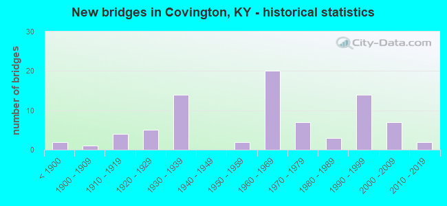
- New bridges - historical statistics
- 2Before 1900
- 11900-1909
- 41910-1919
- 51920-1929
- 141930-1939
- 21950-1959
- 201960-1969
- 71970-1979
- 31980-1989
- 141990-1999
- 72000-2009
- 22010-2019

- Reconstructed bridges - Historical Statistics
- 11950-1959
- 01960-1969
- 01970-1979
- 01980-1989
- 01990-1999
- 12000-2009


- Bridge Condition - Deck
- 59.4%Good
- 21.9%Satisfactory
- 15.6%Fair
- 3.1%Failed

- Bridge Condition - Superstructure
- 21.9%Very good
- 37.5%Good
- 15.6%Satisfactory
- 18.8%Fair
- 3.1%Poor
- 3.1%Failed

- Bridge Condition - Substructure
- 3.1%Very good
- 46.9%Good
- 15.6%Satisfactory
- 31.3%Fair
- 3.1%Failed

- Bridge Condition - Channel
- 17.6%Very good
- 35.3%Good
- 29.4%Satisfactory
- 17.6%Fair

- Bridge Condition - Culverts
- 50.0%Good
- 50.0%Fair
Find on map >> Show street view
Structure Number: 59B00022N, Location: .30 MI EAST OF JCT KY 17 (Lat: 38.991111, Lng: -84.527500), Route carried "on" structure: State highway 1501, Year Built: 1954, Status: Posted for load, Structure Length: 0.82m (2.69ft), Average Daily Traffic: 7,953 (year 2019), Truck Traffic: 2%, Average Future Daily Traffic: 7,396 (year 2039), Design Load: H 15, Features Intersected: WAYMANS BR.
Minimum Vertical Clearance: 30+ m (98+ ft), Kilometerpoint: 0.649, Lanes on structure: 2, Owner: State Highway Agency, Approaching Roadway Width: 5.8m (19.0ft), Skew: 3 degrees, Material/Design: Concrete, Design/Construction: Culvert, Number Of Spans In Main Unit: 2, Length of Maximum Span: 3.7m (12.1ft)
Condition: Channel: Fair, Culverts: Fair, Operating Rating: 20.0 metric tons, Method Used To Determine Operating Rating: Field evaluation and documented engineering judgment, Inventory Rating: 20.0 metric tons, Method Used To Determine Inventory Rating: Field evaluation and documented engineering judgment, Structural Evaluation: Somewhat better than minimum adequacy, Waterway Adequacy: Meets minimum limits, Approach Roadway Alignment: Somewhat better than minimum adequacy, Bridge Posting: Required (Relationship of Operating Rating to Maximum Legal Load: > 39.9% below), Designated Inspection Frequency: Every 24 months, Inspection Date: October 2021
Find on map >> Show street view
Structure Number: 59B00037N, Location: 4TH ST BR OVER LICKING RV (Lat: 39.088056, Lng: -84.504722), Route carried "on" structure: State highway 8, Year Built: 1936, Status: Posted for load, Structure Length: 30.54m (100.20ft), Average Daily Traffic: 17,190 (year 2019), Truck Traffic: 12%, Average Future Daily Traffic: 16,158 (year 2039), Design Load: H 15, Features Intersected: LICKING RIVER, Facility Carried by Structure: 4TH STREET
Minimum Vertical Clearance: 5.38m (17.65ft), Kilometerpoint: 12.286, Lanes on structure: 3, Lanes under structure: 1, Base Highway Network: Yes, Owner: State Highway Agency, Approaching Roadway Width: 9.1m (29.9ft), Navigation Control: Yes ( Vertical Clearance: 19.8m (65.0ft), Horizontal Clearance: 76.2m (250.0ft)), Material/Design: Steel, Design/Construction: Truss - Thru, Number Of Spans In Main Unit: 1, Number Of Approach Spans: 13, Length of Maximum Span: 76.2m (250.0ft), Curb or Sidewalk Widths: Left: 1.2m (3.9ft), Right: 1.2m (3.9ft), Curb-To-Curb Width: 11.0m (36.1ft), Out-to-Out Width: 11.9m (39.0ft)
Condition: Deck: Satisfactory, Superstructure: Poor, Substructure: Fair, Channel: Good, Operating Rating: 28.9 metric tons, Method Used To Determine Operating Rating: Load Factor (LF), Inventory Rating: 17.3 metric tons, Method Used To Determine Inventory Rating: Load Factor (LF), Structural Evaluation: Meets minimum limits, Deck Geometry: High priority of replacement, Underclear: Meets minimum limits, Waterway Adequacy: Equal to present desirable criteria, Approach Roadway Alignment: Equal to present minimum criteria, Bridge Posting: Required (Relationship of Operating Rating to Maximum Legal Load: > 39.9% below), Length Of Structure Improvement: 3.05m (10.01ft), Designated Inspection Frequency: Every 12 months, Critical Feature Inspection Frequency: Every 24 months, Underwater Inspection Frequency: Every 60 months, Inspection Date: April 2021, Critical Feature Inspection Date: April 2020, Underwater Inspection Date: July 2019, Bridge Improvement Cost: $5,922,000, Total Project Cost: $5,921,000, Deck Structure Type: Concrete Cast-file-Place, Wearing Surface/Protective System: Wearing Surface: Low Slump Concrete
Find on map >> Show street view
Structure Number: 59B00038L, Location: SBL .4M S OF 5TH ST NTRCH (Lat: 39.078889, Lng: -84.521667), Route carried "on" structure: Interstate 75, Year Built: 1960, Status: Open, Structure Length: 4.85m (15.91ft), Average Daily Traffic: 79,675 (year 2017), Truck Traffic: 14%, Average Future Daily Traffic: 85,252 (year 2037), Design Load: HS 20, Features Intersected: NINTH ST IN COVINGTON
Minimum Vertical Clearance: 30+ m (98+ ft), Kilometerpoint: 306.916, Lanes on structure: 4, Lanes under structure: 1, Base Highway Network: Yes, Owner: State Highway Agency, Approaching Roadway Width: 16.5m (54.1ft), Material/Design: Concrete, Design/Construction: Tee Beam, Number Of Spans In Main Unit: 3, Length of Maximum Span: 15.2m (49.9ft), Curb or Sidewalk Widths: Left: 0.5m (1.6ft), Right: 0.5m (1.6ft), Curb-To-Curb Width: 26.8m (87.9ft), Out-to-Out Width: 27.7m (90.9ft)
Condition: Deck: Good, Superstructure: Good, Substructure: Satisfactory, Operating Rating: 81.0 metric tons, Method Used To Determine Operating Rating: Load Factor (LF), Inventory Rating: 48.6 metric tons, Method Used To Determine Inventory Rating: Load Factor (LF), Structural Evaluation: Equal to present minimum criteria, Deck Geometry: Superior to present desirable criteria, Underclear: Superior to present desirable criteria, Approach Roadway Alignment: Superior to present desirable criteria, Length Of Structure Improvement: 0.48m (1.57ft), Designated Inspection Frequency: Every 24 months, Inspection Date: November 2021, Bridge Improvement Cost: $1,145,000, Total Project Cost: $1,144,000, Deck Structure Type: Concrete Cast-file-Place, Wearing Surface/Protective System: Wearing Surface: Low Slump Concrete
Find on map >> Show street view
Structure Number: 59B00038R, Location: NBL .4M S OF 5TH ST NTRCH (Lat: 39.079167, Lng: -84.521389), Route carried "on" structure: Interstate 75, Year Built: 1960, Status: Open, Structure Length: 4.85m (15.91ft), Average Daily Traffic: 79,675 (year 2017), Truck Traffic: 14%, Average Future Daily Traffic: 85,252 (year 2037), Design Load: HS 20, Features Intersected: NINTH ST IN COVINGTON
Minimum Vertical Clearance: 30+ m (98+ ft), Kilometerpoint: 306.929, Lanes on structure: 3, Lanes under structure: 1, Base Highway Network: Yes, Owner: State Highway Agency, Approaching Roadway Width: 16.5m (54.1ft), Material/Design: Concrete, Design/Construction: Tee Beam, Number Of Spans In Main Unit: 3, Length of Maximum Span: 15.2m (49.9ft), Curb or Sidewalk Widths: Left: 0.5m (1.6ft), Right: 0.5m (1.6ft), Curb-To-Curb Width: 16.8m (55.1ft), Out-to-Out Width: 17.7m (58.1ft)
Condition: Deck: Good, Superstructure: Good, Substructure: Satisfactory, Operating Rating: 81.0 metric tons, Method Used To Determine Operating Rating: Load Factor (LF), Inventory Rating: 48.6 metric tons, Method Used To Determine Inventory Rating: Load Factor (LF), Structural Evaluation: Equal to present minimum criteria, Deck Geometry: Equal to present minimum criteria, Underclear: Somewhat better than minimum adequacy, Approach Roadway Alignment: Superior to present desirable criteria, Length Of Structure Improvement: 0.48m (1.57ft), Designated Inspection Frequency: Every 24 months, Inspection Date: November 2021, Bridge Improvement Cost: $1,145,000, Total Project Cost: $1,144,000, Deck Structure Type: Concrete Cast-file-Place, Wearing Surface/Protective System: Wearing Surface: Low Slump Concrete
Find on map >> Show street view
Structure Number: 59B00039N, Location: SB EXT RMP @5TH ST NTRCH (Lat: 39.085278, Lng: -84.523333), Route carried "on" structure: State highway 8, Year Built: 1963, Status: Open, Structure Length: 1.89m (6.20ft), Average Daily Traffic: 5,036 (year 2020), Truck Traffic: 5%, Average Future Daily Traffic: 4,733 (year 2040), Design Load: HS 20, Features Intersected: 4TH ST RAMP TO SB I-75, Facility Carried by Structure: 5TH ST/SB I75 RMP
Minimum Vertical Clearance: 30+ m (98+ ft), Kilometerpoint: 10.503, Lanes on structure: 1, Lanes under structure: 1, Base Highway Network: Yes, Owner: State Highway Agency, Approaching Roadway Width: 4.3m (14.1ft), Material/Design: Concrete, Design/Construction: Tee Beam, Number Of Spans In Main Unit: 1, Length of Maximum Span: 9.4m (30.8ft), Curb or Sidewalk Widths: Left: 0.0m, Right: 1.4m (4.6ft), Curb-To-Curb Width: 18.9m (62.0ft), Out-to-Out Width: 21.0m (68.9ft)
Condition: Deck: Satisfactory, Superstructure: Satisfactory, Substructure: Satisfactory, Operating Rating: 75.2 metric tons, Method Used To Determine Operating Rating: Load Factor (LF), Inventory Rating: 45.1 metric tons, Method Used To Determine Inventory Rating: Load Factor (LF), Structural Evaluation: Equal to present minimum criteria, Deck Geometry: Superior to present desirable criteria, Underclear: Equal to present minimum criteria, Approach Roadway Alignment: Equal to present minimum criteria, Designated Inspection Frequency: Every 24 months, Inspection Date: November 2021, Deck Structure Type: Concrete Cast-file-Place, Wearing Surface/Protective System: Wearing Surface: Latex Concrete
Find on map >> Show street view
Structure Number: 59B00040N, Location: APPROACH TO BRENT SPENCE (Lat: 39.086817, Lng: -84.522808), Route carried "on" structure: Interstate 75, Year Built: 1963, Year Reconstructed: 2007, Status: Open, Structure Length: 95.49m (313.29ft), Average Daily Traffic: 132,112 (year 2020), Truck Traffic: 15%, Average Future Daily Traffic: 141,359 (year 2040), Design Load: HS 20, Features Intersected: 3RD-4TH-5TH STS COVINGTO
Minimum Vertical Clearance: 30+ m (98+ ft), Kilometerpoint: 307.782, Lanes on structure: 7, Lanes under structure: 5, Base Highway Network: Yes, Owner: State Highway Agency, Approaching Roadway Width: 12.8m (42.0ft), Material/Design: Steel, Design/Construction: Stringer/Multi-beam, Number Of Spans In Main Unit: 1, Number Of Approach Spans: 43, Length of Maximum Span: 22.9m (75.1ft), Curb or Sidewalk Widths: Left: 0.5m (1.6ft), Right: 0.5m (1.6ft), Curb-To-Curb Width: 9.1m (29.9ft), Out-to-Out Width: 11.0m (36.1ft)
Condition: Deck: Fair, Superstructure: Fair, Substructure: Fair, Operating Rating: 34.3 metric tons, Method Used To Determine Operating Rating: Load and Resistance Factor Rating (LRFR) rating reported by rating factor(RF) method using HL-93 loadings, Inventory Rating: 26.2 metric tons, Method Used To Determine Inventory Rating: Load and Resistance Factor Rating (LRFR) rating reported by rating factor(RF) method using HL-93 loadings, Structural Evaluation: Somewhat better than minimum adequacy, Deck Geometry: High priority of replacement, Underclear: Equal to present minimum criteria, Approach Roadway Alignment: Equal to present desirable criteria, Length Of Structure Improvement: 3.62m (11.88ft), Designated Inspection Frequency: Every 24 months, Critical Feature Inspection Frequency: Every 24 months, Inspection Date: September 2020, Critical Feature Inspection Date: September 2020, Bridge Improvement Cost: $5,000, Total Project Cost: $5,000, Deck Structure Type: Concrete Cast-file-Place, Wearing Surface/Protective System: Wearing Surface: Low Slump Concrete
Find on map >> Show street view
Structure Number: 59B00044L, Location: SBL-.3M N-JEFFERSON ST OP (Lat: 39.076667, Lng: -84.520000), Route carried "on" structure: Interstate 75, Year Built: 1960, Status: Open, Structure Length: 20.85m (68.41ft), Average Daily Traffic: 79,675 (year 2017), Truck Traffic: 14%, Average Future Daily Traffic: 85,252 (year 2037), Design Load: HS 20, Features Intersected: 11TH-12TH-LEWIS IN CVNGT
Minimum Vertical Clearance: 30+ m (98+ ft), Kilometerpoint: 306.607, Lanes on structure: 4, Lanes under structure: 6, Base Highway Network: Yes, Owner: State Highway Agency, Approaching Roadway Width: 16.5m (54.1ft), Material/Design: Concrete continuous, Design/Construction: Tee Beam, Number Of Spans In Main Unit: 3, Number Of Approach Spans: 9, Length of Maximum Span: 24.4m (80.1ft), Curb or Sidewalk Widths: Left: 0.5m (1.6ft), Right: 0.5m (1.6ft), Curb-To-Curb Width: 26.2m (86.0ft), Out-to-Out Width: 27.1m (88.9ft)
Condition: Deck: Fair, Superstructure: Fair, Substructure: Fair, Operating Rating: 70.9 metric tons, Method Used To Determine Operating Rating: Load Factor (LF), Inventory Rating: 42.5 metric tons, Method Used To Determine Inventory Rating: Load Factor (LF), Structural Evaluation: Somewhat better than minimum adequacy, Deck Geometry: Superior to present desirable criteria, Underclear: High priority of corrective action, Approach Roadway Alignment: Superior to present desirable criteria, Length Of Structure Improvement: 2.08m (6.82ft), Designated Inspection Frequency: Every 24 months, Inspection Date: November 2021, Bridge Improvement Cost: $4,925,000, Total Project Cost: $4,924,000, Deck Structure Type: Concrete Cast-file-Place, Wearing Surface/Protective System: Wearing Surface: Low Slump Concrete, Deck Protection: Epoxy Coated Reinforcing
Find on map >> Show street view
Structure Number: 59B00044R, Location: NBL-.3M N-JEFFERSON ST OP (Lat: 39.076667, Lng: -84.519722), Route carried "on" structure: Interstate 75, Year Built: 1960, Status: Open, Structure Length: 20.85m (68.41ft), Average Daily Traffic: 79,675 (year 2017), Truck Traffic: 14%, Average Future Daily Traffic: 85,252 (year 2037), Design Load: HS 20, Features Intersected: US25,KY1120,(11TH,12TH,L
Minimum Vertical Clearance: 30+ m (98+ ft), Kilometerpoint: 306.607, Lanes on structure: 3, Lanes under structure: 6, Base Highway Network: Yes, Owner: State Highway Agency, Approaching Roadway Width: 16.5m (54.1ft), Material/Design: Concrete continuous, Design/Construction: Tee Beam, Number Of Spans In Main Unit: 3, Number Of Approach Spans: 9, Length of Maximum Span: 24.4m (80.1ft), Curb or Sidewalk Widths: Left: 0.5m (1.6ft), Right: 0.5m (1.6ft), Curb-To-Curb Width: 16.5m (54.1ft), Out-to-Out Width: 26.5m (86.9ft)
Condition: Deck: Fair, Superstructure: Fair, Substructure: Fair, Operating Rating: 70.9 metric tons, Method Used To Determine Operating Rating: Load Factor (LF), Inventory Rating: 42.5 metric tons, Method Used To Determine Inventory Rating: Load Factor (LF), Structural Evaluation: Somewhat better than minimum adequacy, Deck Geometry: Equal to present minimum criteria, Underclear: High priority of corrective action, Approach Roadway Alignment: Superior to present desirable criteria, Length Of Structure Improvement: 2.08m (6.82ft), Designated Inspection Frequency: Every 24 months, Inspection Date: November 2021, Bridge Improvement Cost: $4,925,000, Total Project Cost: $4,924,000, Deck Structure Type: Concrete Cast-file-Place, Wearing Surface/Protective System: Wearing Surface: Low Slump Concrete, Deck Protection: Epoxy Coated Reinforcing
Find on map >> Show street view
Structure Number: 59B00046N, Location: BRENT SPENCE BR OVER OHIO (Lat: 39.090556, Lng: -84.522500), Route carried "on" structure: Interstate 75, Year Built: 1963, Status: Open, Structure Length: 52.93m (173.65ft), Average Daily Traffic: 132,112 (year 2020), Truck Traffic: 15%, Average Future Daily Traffic: 141,359 (year 2040), Design Load: HS 20, Features Intersected: OHIO RIVER
Minimum Vertical Clearance: 5.59m (18.34ft), Kilometerpoint: 308.247, Lanes on structure: 8, Base Highway Network: Yes, Owner: State Highway Agency, Approaching Roadway Width: 14.0m (45.9ft), Skew: 10 degrees, Navigation Control: Yes ( Vertical Clearance: 28.2m (92.5ft), Horizontal Clearance: 243.8m (799.9ft)), Material/Design: Steel continuous, Design/Construction: Truss - Thru, Number Of Spans In Main Unit: 3, Length of Maximum Span: 253.1m (830.4ft), Curb-To-Curb Width: 27.9m (91.5ft), Out-to-Out Width: 28.7m (94.2ft)
Condition: Deck: Fair, Superstructure: Fair, Substructure: Fair, Channel: Good, Operating Rating: 43.5 metric tons, Method Used To Determine Operating Rating: Load Factor (LF), Inventory Rating: 26.1 metric tons, Method Used To Determine Inventory Rating: Load Factor (LF), Structural Evaluation: Somewhat better than minimum adequacy, Deck Geometry: High priority of replacement, Waterway Adequacy: Superior to present desirable criteria, Approach Roadway Alignment: Equal to present desirable criteria, Length Of Structure Improvement: 5.29m (17.36ft), Designated Inspection Frequency: Every 24 months, Critical Feature Inspection Frequency: Every 24 months, Underwater Inspection Frequency: Every 60 months, Inspection Date: September 2020, Critical Feature Inspection Date: September 2020, Underwater Inspection Date: August 2017, Bridge Improvement Cost: $21,322,000, Total Project Cost: $21,321,000, Deck Structure Type: Concrete Cast-file-Place, Wearing Surface/Protective System: Wearing Surface: Latex Concrete
Find on map >> Show street view
Structure Number: 59B00048N, Location: SUSPENSION BR OVR OHIO RV (Lat: 39.092778, Lng: -84.510000), Route carried "on" structure: State highway 17, Year Built: 1867, Year Reconstructed: 1955, Status: Posted for load, Structure Length: 65.90m (216.21ft), Average Daily Traffic: 9,054 (year 2018), Truck Traffic: 13%, Average Future Daily Traffic: 8,510 (year 2038), Design Load: H 20, Features Intersected: OHIO RIVER
Minimum Vertical Clearance: 6.51m (21.36ft), Kilometerpoint: 38.874, Lanes on structure: 2, Lanes under structure: 1, Base Highway Network: Yes, Owner: State Highway Agency, Approaching Roadway Width: 8.2m (26.9ft), Navigation Control: Yes ( Vertical Clearance: 20.8m (68.2ft), Horizontal Clearance: 304.8m (1,000.0ft)), Material/Design: Steel, Design/Construction: Suspension, Number Of Spans In Main Unit: 3, Number Of Approach Spans: 11, Length of Maximum Span: 322.2m (1,057.1ft), Curb or Sidewalk Widths: Left: 2.4m (7.9ft), Right: 2.4m (7.9ft), Curb-To-Curb Width: 7.6m (24.9ft), Out-to-Out Width: 9.2m (30.2ft)
Condition: Deck: Satisfactory, Superstructure: Fair, Substructure: Fair, Channel: Good, Operating Rating: 10.1 metric tons, Method Used To Determine Operating Rating: Load Factor (LF), Inventory Rating: 10.0 metric tons, Method Used To Determine Inventory Rating: Load Factor (LF), Structural Evaluation: High priority of replacement, Deck Geometry: High priority of replacement, Waterway Adequacy: Superior to present desirable criteria, Approach Roadway Alignment: Equal to present minimum criteria, Bridge Posting: Required (Relationship of Operating Rating to Maximum Legal Load: > 39.9% below), Length Of Structure Improvement: 6.23m (20.44ft), Designated Inspection Frequency: Every 12 months, Critical Feature Inspection Frequency: Every 24 months, Underwater Inspection Frequency: Every 60 months, Inspection Date: August 2021, Critical Feature Inspection Date: August 2020, Underwater Inspection Date: August 2017, Bridge Improvement Cost: $9,826,000, Total Project Cost: $9,826,000, Deck Structure Type: Open Grating
Find on map >> Show street view
Structure Number: 59B00049N, Location: CLAY WADE BAILEY OVR OHIO (Lat: 39.091314, Lng: -84.519361), Route carried "on" structure: US 25, Year Built: 1974, Status: Open, Structure Length: 67.34m (220.93ft), Average Daily Traffic: 13,531 (year 2019), Truck Traffic: 11%, Average Future Daily Traffic: 12,583 (year 2039), Design Load: HS 20+Mod, Features Intersected: OHIO RIVER
Minimum Vertical Clearance: 5.49m (18.01ft), Kilometerpoint: 22.090, Lanes on structure: 2, Lanes under structure: 3, Owner: State Highway Agency, Approaching Roadway Width: 10.4m (34.1ft), Navigation Control: Yes ( Vertical Clearance: 25.0m (82.0ft), Horizontal Clearance: 196.6m (645.0ft)), Material/Design: Steel, Design/Construction: Truss - Thru, Number Of Spans In Main Unit: 3, Number Of Approach Spans: 7, Length of Maximum Span: 205.7m (674.9ft), Curb or Sidewalk Widths: Left: 0.0m, Right: 1.2m (3.9ft), Curb-To-Curb Width: 13.0m (42.7ft), Out-to-Out Width: 14.2m (46.6ft)
Condition: Deck: Fair, Superstructure: Satisfactory, Substructure: Fair, Channel: Good, Operating Rating: 52.9 metric tons, Method Used To Determine Operating Rating: Load Factor (LF), Inventory Rating: 31.7 metric tons, Method Used To Determine Inventory Rating: Load Factor (LF), Structural Evaluation: Somewhat better than minimum adequacy, Deck Geometry: Somewhat better than minimum adequacy, Waterway Adequacy: Superior to present desirable criteria, Approach Roadway Alignment: Equal to present minimum criteria, Designated Inspection Frequency: Every 24 months, Critical Feature Inspection Frequency: Every 24 months, Underwater Inspection Frequency: Every 60 months, Inspection Date: June 2020, Critical Feature Inspection Date: June 2020, Underwater Inspection Date: August 2017, Deck Structure Type: Concrete Cast-file-Place, Wearing Surface/Protective System: Wearing Surface: Latex Concrete
Find on map >> Show street view
Structure Number: 59B00067L, Location: SBL S-@N-JCT OLD KY 17 (Lat: 39.016389, Lng: -84.529444), Route carried "on" structure: State highway 17, Year Built: 1974, Status: Open, Structure Length: 15.58m (51.12ft), Average Daily Traffic: 16,119 (year 2020), Truck Traffic: 26%, Average Future Daily Traffic: 14,991 (year 2040), Design Load: HS 20+Mod, Features Intersected: CSX RR & BANKLICK CR, Facility Carried by Structure: MADISON PIKE NC
Minimum Vertical Clearance: 30+ m (98+ ft), Kilometerpoint: 28.403, Lanes on structure: 2, Owner: State Highway Agency, Approaching Roadway Width: 10.7m (35.1ft), Skew: 24 degrees, Material/Design: Prestressed concrete, Design/Construction: Stringer/Multi-beam, Number Of Spans In Main Unit: 7, Length of Maximum Span: 21.9m (71.9ft), Curb or Sidewalk Widths: Left: 1.1m (3.6ft), Right: 2.4m (7.9ft), Curb-To-Curb Width: 11.0m (36.1ft), Out-to-Out Width: 14.5m (47.6ft)
Condition: Deck: Good, Superstructure: Good, Substructure: Good, Channel: Fair, Operating Rating: 74.2 metric tons, Method Used To Determine Operating Rating: Load Factor (LF), Inventory Rating: 44.5 metric tons, Method Used To Determine Inventory Rating: Load Factor (LF), Structural Evaluation: Better than present minimum criteria, Deck Geometry: Equal to present minimum criteria, Waterway Adequacy: Equal to present desirable criteria, Approach Roadway Alignment: Equal to present desirable criteria, Designated Inspection Frequency: Every 24 months, Inspection Date: October 2021, Deck Structure Type: Concrete Cast-file-Place, Wearing Surface/Protective System: Wearing Surface: Latex Concrete, Deck Protection: Epoxy Coated Reinforcing
Find on map >> Show street view
Structure Number: 59B00067R, Location: NBL S-@N-JCT OLD KY 17 (Lat: 39.016389, Lng: -84.529444), Route carried "on" structure: State highway 17, Year Built: 1974, Status: Open, Structure Length: 15.58m (51.12ft), Average Daily Traffic: 16,119 (year 2020), Truck Traffic: 26%, Average Future Daily Traffic: 14,991 (year 2040), Design Load: HS 20+Mod, Features Intersected: CSX RR & BANKLICK CR, Facility Carried by Structure: MADISON ROAD/MADIS
Minimum Vertical Clearance: 30+ m (98+ ft), Kilometerpoint: 28.416, Lanes on structure: 2, Owner: State Highway Agency, Approaching Roadway Width: 10.7m (35.1ft), Skew: 24 degrees, Material/Design: Prestressed concrete, Design/Construction: Stringer/Multi-beam, Number Of Spans In Main Unit: 8, Length of Maximum Span: 21.9m (71.9ft), Curb or Sidewalk Widths: Left: 2.4m (7.9ft), Right: 1.1m (3.6ft), Curb-To-Curb Width: 11.0m (36.1ft), Out-to-Out Width: 14.5m (47.6ft)
Condition: Deck: Good, Superstructure: Good, Substructure: Good, Channel: Good, Operating Rating: 87.8 metric tons, Method Used To Determine Operating Rating: Load Factor (LF), Inventory Rating: 52.7 metric tons, Method Used To Determine Inventory Rating: Load Factor (LF), Structural Evaluation: Better than present minimum criteria, Deck Geometry: Equal to present minimum criteria, Waterway Adequacy: Equal to present desirable criteria, Approach Roadway Alignment: Equal to present desirable criteria, Designated Inspection Frequency: Every 24 months, Inspection Date: October 2021, Deck Structure Type: Concrete Cast-file-Place, Wearing Surface/Protective System: Wearing Surface: Latex Concrete, Deck Protection: Epoxy Coated Reinforcing
Find on map >> Show street view
Structure Number: 59B00071N, Location: .80 MI NOR. OF I-275 OP (Lat: 39.033611, Lng: -84.494722), Route carried "on" structure: State highway 177, Year Built: 1976, Status: Open, Structure Length: 10.67m (35.01ft), Average Daily Traffic: 1,598 (year 2020), Truck Traffic: 4%, Average Future Daily Traffic: 1,486 (year 2040), Design Load: HS 20, Features Intersected: BANKLICK CREEK, Facility Carried by Structure: DECOURSEY ROAD
Minimum Vertical Clearance: 30+ m (98+ ft), Kilometerpoint: 30.978, Lanes on structure: 2, Owner: State Highway Agency, Approaching Roadway Width: 12.8m (42.0ft), Skew: 3 degrees, Material/Design: Steel continuous, Design/Construction: Stringer/Multi-beam, Number Of Spans In Main Unit: 3, Length of Maximum Span: 41.1m (134.8ft), Curb or Sidewalk Widths: Left: 2.6m (8.5ft), Right: 0.5m (1.6ft), Curb-To-Curb Width: 9.1m (29.9ft), Out-to-Out Width: 12.5m (41.0ft)
Condition: Deck: Good, Superstructure: Good, Substructure: Good, Channel: Very good, Operating Rating: 58.3 metric tons, Method Used To Determine Operating Rating: Load Factor (LF), Inventory Rating: 35.0 metric tons, Method Used To Determine Inventory Rating: Load Factor (LF), Structural Evaluation: Better than present minimum criteria, Deck Geometry: Somewhat better than minimum adequacy, Waterway Adequacy: Superior to present desirable criteria, Approach Roadway Alignment: Equal to present minimum criteria, Designated Inspection Frequency: Every 24 months, Inspection Date: November 2021, Deck Structure Type: Concrete Cast-file-Place, Wearing Surface/Protective System: Wearing Surface: Latex Concrete
Find on map >> Show street view
Structure Number: 59B00074N, Location: .1 MI. S. JCT. KY 1486 (Lat: 38.979722, Lng: -84.540556), Route carried "on" structure: State highway 3035, Year Built: 1981, Status: Open, Structure Length: 1.89m (6.20ft), Average Daily Traffic: 3,012 (year 2020), Truck Traffic: 7%, Average Future Daily Traffic: 2,801 (year 2040), Design Load: HS 20, Features Intersected: FOWLERCREEK
Minimum Vertical Clearance: 30+ m (98+ ft), Kilometerpoint: 2.752, Lanes on structure: 2, Owner: State Highway Agency, Approaching Roadway Width: 6.7m (22.0ft), Material/Design: Prestressed concrete, Design/Construction: Stringer/Multi-beam, Number Of Spans In Main Unit: 1, Length of Maximum Span: 17.4m (57.1ft), Curb or Sidewalk Widths: Left: 0.3m (1.0ft), Right: 0.3m (1.0ft), Curb-To-Curb Width: 12.2m (40.0ft), Out-to-Out Width: 12.9m (42.3ft)
Condition: Deck: Good, Superstructure: Good, Substructure: Good, Channel: Good, Operating Rating: 59.2 metric tons, Method Used To Determine Operating Rating: Load Factor (LF), Inventory Rating: 35.6 metric tons, Method Used To Determine Inventory Rating: Load Factor (LF), Structural Evaluation: Better than present minimum criteria, Deck Geometry: Equal to present minimum criteria, Waterway Adequacy: Equal to present minimum criteria, Approach Roadway Alignment: Equal to present minimum criteria, Designated Inspection Frequency: Every 24 months, Inspection Date: October 2021, Deck Structure Type: Concrete Cast-file-Place, Wearing Surface/Protective System: Wearing Surface: Low Slump Concrete, Deck Protection: Epoxy Coated Reinforcing
Find on map >> Show street view
Structure Number: 59B00075N, Location: .05 MI S OF JCT KY 1501 (Lat: 38.989722, Lng: -84.532778), Route carried "on" structure: State highway 3035, Year Built: 1983, Status: Open, Structure Length: 1.04m (3.41ft), Average Daily Traffic: 769 (year 2019), Truck Traffic: 7%, Average Future Daily Traffic: 722 (year 2039), Design Load: HS 20, Features Intersected: WAYMAN BRANCH
Minimum Vertical Clearance: 30+ m (98+ ft), Kilometerpoint: 4.196, Lanes on structure: 2, Owner: State Highway Agency, Approaching Roadway Width: 6.4m (21.0ft), Material/Design: Prestressed concrete, Design/Construction: Box Beam or Girders - Single/Spread, Number Of Spans In Main Unit: 1, Length of Maximum Span: 9.8m (32.2ft), Curb or Sidewalk Widths: Left: 0.5m (1.6ft), Right: 0.5m (1.6ft), Curb-To-Curb Width: 12.0m (39.4ft), Out-to-Out Width: 13.0m (42.7ft)
Condition: Deck: Good, Superstructure: Very good, Substructure: Good, Channel: Fair, Operating Rating: 97.4 metric tons, Method Used To Determine Operating Rating: Load Factor (LF), Inventory Rating: 58.4 metric tons, Method Used To Determine Inventory Rating: Load Factor (LF), Structural Evaluation: Better than present minimum criteria, Deck Geometry: Better than present minimum criteria, Waterway Adequacy: Equal to present minimum criteria, Approach Roadway Alignment: Equal to present minimum criteria, Designated Inspection Frequency: Every 24 months, Inspection Date: October 2021, Deck Structure Type: Concrete Cast-file-Place, Wearing Surface/Protective System: Wearing Surface: Monolithic Concrete
Find on map >> Show street view
Structure Number: 59B00081L, Location: 400.FT E. RUSSELL ST. (Lat: 39.077500, Lng: -84.510278), Route carried "on" structure: State highway 1120, Year Built: 1983, Status: Open, Structure Length: 16.67m (54.69ft), Average Daily Traffic: 7,359 (year 2019), Truck Traffic: 9%, Average Future Daily Traffic: 6,917 (year 2039), Design Load: HS 20, Features Intersected: CSX RR
Minimum Vertical Clearance: 30+ m (98+ ft), Kilometerpoint: 0.832, Lanes on structure: 2, Base Highway Network: Yes, Owner: State Highway Agency, Approaching Roadway Width: 11.0m (36.1ft), Material/Design: Steel continuous, Design/Construction: Stringer/Multi-beam, Number Of Spans In Main Unit: 3, Number Of Approach Spans: 4, Length of Maximum Span: 32.6m (107.0ft), Curb or Sidewalk Widths: Left: 1.8m (5.9ft), Right: 0.5m (1.6ft), Curb-To-Curb Width: 9.1m (29.9ft), Out-to-Out Width: 11.8m (38.7ft)
Condition: Deck: Satisfactory, Superstructure: Satisfactory, Substructure: Satisfactory, Operating Rating: 48.3 metric tons, Method Used To Determine Operating Rating: Load Factor (LF), Inventory Rating: 28.9 metric tons, Method Used To Determine Inventory Rating: Load Factor (LF), Structural Evaluation: Equal to present minimum criteria, Deck Geometry: Meets minimum limits, Underclear: High priority of corrective action, Approach Roadway Alignment: Equal to present minimum criteria, Length Of Structure Improvement: 1.67m (5.48ft), Designated Inspection Frequency: Every 24 months, Inspection Date: November 2021, Bridge Improvement Cost: $2,637,000, Total Project Cost: $2,637,000, Deck Structure Type: Concrete Cast-file-Place, Wearing Surface/Protective System: Wearing Surface: Monolithic Concrete, Deck Protection: Epoxy Coated Reinforcing
Find on map >> Show street view
Structure Number: 59B00085N, Location: 500'S. SUSPENSION BRIDGE (Lat: 39.089722, Lng: -84.509167), Route carried "on" structure: State highway 17, Year Built: 1992, Status: Open, Structure Length: 1.58m (5.18ft), Average Daily Traffic: 9,054 (year 2018), Truck Traffic: 13%, Average Future Daily Traffic: 8,510 (year 2038), Design Load: HS 25 or greater, Features Intersected: SECOND STREET, Facility Carried by Structure: SUSP. BRIDGE APPR
Minimum Vertical Clearance: 30+ m (98+ ft), Kilometerpoint: 38.487, Lanes on structure: 2, Lanes under structure: 2, Base Highway Network: Yes, Owner: State Highway Agency, Approaching Roadway Width: 16.5m (54.1ft), Material/Design: Prestressed concrete, Design/Construction: Box Beam or Girders - Multiple, Number Of Spans In Main Unit: 1, Length of Maximum Span: 15.8m (51.8ft), Curb or Sidewalk Widths: Left: 3.4m (11.2ft), Right: 3.4m (11.2ft), Curb-To-Curb Width: 16.5m (54.1ft), Out-to-Out Width: 23.2m (76.1ft)
Condition: Deck: Satisfactory, Superstructure: Satisfactory, Substructure: Good, Operating Rating: 53.2 metric tons, Method Used To Determine Operating Rating: Load Factor (LF), Inventory Rating: 31.9 metric tons, Method Used To Determine Inventory Rating: Load Factor (LF), Structural Evaluation: Equal to present minimum criteria, Deck Geometry: Superior to present desirable criteria, Underclear: High priority of corrective action, Approach Roadway Alignment: Equal to present minimum criteria, Length Of Structure Improvement: 0.16m (0.52ft), Designated Inspection Frequency: Every 24 months, Inspection Date: November 2021, Bridge Improvement Cost: $494,000, Total Project Cost: $494,000, Deck Structure Type: Concrete Cast-file-Place, Wearing Surface/Protective System: Wearing Surface: Monolithic Concrete, Deck Protection: Epoxy Coated Reinforcing
Find on map >> Show street view
Structure Number: 59B00086N, Location: .1 MI N.W.-KY 204 (Lat: 38.977222, Lng: -84.487222), Route carried "on" structure: State highway 177, Year Built: 1992, Status: Open, Structure Length: 5.03m (16.50ft), Average Daily Traffic: 2,105 (year 2019), Truck Traffic: 4%, Average Future Daily Traffic: 1,957 (year 2039), Design Load: HS 25 or greater, Features Intersected: DECOURSEY CREEK, Facility Carried by Structure: DECOURSEY ROAD
Minimum Vertical Clearance: 30+ m (98+ ft), Kilometerpoint: 24.497, Lanes on structure: 2, Owner: State Highway Agency, Approaching Roadway Width: 7.0m (23.0ft), Skew: 5 degrees, Material/Design: Prestressed concrete continuous, Design/Construction: Stringer/Multi-beam, Number Of Spans In Main Unit: 3, Length of Maximum Span: 16.8m (55.1ft), Curb or Sidewalk Widths: Left: 0.5m (1.6ft), Right: 0.5m (1.6ft), Curb-To-Curb Width: 9.8m (32.2ft), Out-to-Out Width: 10.8m (35.4ft)
Condition: Deck: Good, Superstructure: Very good, Substructure: Good, Channel: Satisfactory, Operating Rating: 71.6 metric tons, Method Used To Determine Operating Rating: Load Factor (LF), Inventory Rating: 42.9 metric tons, Method Used To Determine Inventory Rating: Load Factor (LF), Structural Evaluation: Better than present minimum criteria, Deck Geometry: Meets minimum limits, Waterway Adequacy: Equal to present desirable criteria, Approach Roadway Alignment: Equal to present desirable criteria, Designated Inspection Frequency: Every 24 months, Inspection Date: October 2021, Deck Structure Type: Concrete Cast-file-Place, Wearing Surface/Protective System: Wearing Surface: Monolithic Concrete, Deck Protection: Epoxy Coated Reinforcing
Find on map >> Show street view
Structure Number: 59B00087N, Location: I-75 NB-EXIT E TO 5TH ST (Lat: 39.078056, Lng: -84.520278), Route carried "on" structure: Ramp Interstate 75, Year Built: 1993, Status: Open, Structure Length: 2.59m (8.50ft), Average Daily Traffic: 159,350 (year 2017), Truck Traffic: 14%, Average Future Daily Traffic: 170,504 (year 2037), Design Load: HS 25 or greater, Features Intersected: PIKE ST-ON RMP TO I-75 N
Minimum Vertical Clearance: 30+ m (98+ ft), Kilometerpoint: 306.781, Lanes on structure: 1, Lanes under structure: 1, Owner: State Highway Agency, Approaching Roadway Width: 7.9m (25.9ft), Skew: 6 degrees, Material/Design: Prestressed concrete, Design/Construction: Stringer/Multi-beam, Number Of Spans In Main Unit: 1, Length of Maximum Span: 16.2m (53.1ft), Curb or Sidewalk Widths: Left: 0.5m (1.6ft), Right: 0.5m (1.6ft), Curb-To-Curb Width: 7.9m (25.9ft), Out-to-Out Width: 8.8m (28.9ft)
Condition: Deck: Good, Superstructure: Good, Substructure: Satisfactory, Operating Rating: 89.2 metric tons, Method Used To Determine Operating Rating: Load Factor (LF), Inventory Rating: 53.5 metric tons, Method Used To Determine Inventory Rating: Load Factor (LF), Structural Evaluation: Equal to present minimum criteria, Deck Geometry: Equal to present desirable criteria, Underclear: Meets minimum limits, Approach Roadway Alignment: Equal to present minimum criteria, Length Of Structure Improvement: 0.24m (0.79ft), Designated Inspection Frequency: Every 24 months, Inspection Date: November 2021, Bridge Improvement Cost: $293,000, Total Project Cost: $293,000, Deck Structure Type: Concrete Cast-file-Place, Wearing Surface/Protective System: Wearing Surface: Monolithic Concrete, Deck Protection: Epoxy Coated Reinforcing
Find on map >> Show street view
Structure Number: 59B00088N, Location: I75 NB TO 5TH ST OVR 9TH (Lat: 39.079167, Lng: -84.521111), Route carried "on" structure: Ramp Interstate 75, Year Built: 1993, Status: Open, Structure Length: 4.85m (15.91ft), Average Daily Traffic: 159,350 (year 2017), Truck Traffic: 14%, Average Future Daily Traffic: 170,504 (year 2037), Design Load: HS 25 or greater, Features Intersected: 9TH ST (I-75NB) RAMP'G'
Minimum Vertical Clearance: 30+ m (98+ ft), Kilometerpoint: 306.916, Lanes on structure: 1, Lanes under structure: 1, Owner: State Highway Agency, Approaching Roadway Width: 7.9m (25.9ft), Material/Design: Prestressed concrete continuous, Design/Construction: Stringer/Multi-beam, Number Of Spans In Main Unit: 3, Length of Maximum Span: 16.2m (53.1ft), Curb or Sidewalk Widths: Left: 0.5m (1.6ft), Right: 0.5m (1.6ft), Curb-To-Curb Width: 7.9m (25.9ft), Out-to-Out Width: 8.8m (28.9ft)
Condition: Deck: Good, Superstructure: Very good, Substructure: Good, Operating Rating: 75.3 metric tons, Method Used To Determine Operating Rating: Load Factor (LF), Inventory Rating: 45.2 metric tons, Method Used To Determine Inventory Rating: Load Factor (LF), Structural Evaluation: Better than present minimum criteria, Deck Geometry: Equal to present desirable criteria, Underclear: Meets minimum limits, Approach Roadway Alignment: Equal to present minimum criteria, Designated Inspection Frequency: Every 24 months, Inspection Date: November 2021, Deck Structure Type: Concrete Cast-file-Place, Wearing Surface/Protective System: Wearing Surface: Monolithic Concrete, Deck Protection: Epoxy Coated Reinforcing
Find on map >> Show street view
Structure Number: 59B00089N, Location: PIKE ST TO I75NB OVR 9TH (Lat: 39.079167, Lng: -84.521389), Route carried "on" structure: Ramp Interstate 75, Year Built: 1993, Status: Open, Structure Length: 4.85m (15.91ft), Average Daily Traffic: 159,350 (year 2017), Truck Traffic: 14%, Average Future Daily Traffic: 170,504 (year 2037), Design Load: HS 25 or greater, Features Intersected: 9TH ST (COV)
Minimum Vertical Clearance: 30+ m (98+ ft), Kilometerpoint: 306.916, Lanes on structure: 1, Lanes under structure: 1, Owner: State Highway Agency, Approaching Roadway Width: 7.9m (25.9ft), Material/Design: Prestressed concrete continuous, Design/Construction: Stringer/Multi-beam, Number Of Spans In Main Unit: 3, Length of Maximum Span: 16.2m (53.1ft), Curb or Sidewalk Widths: Left: 0.5m (1.6ft), Right: 0.5m (1.6ft), Curb-To-Curb Width: 7.9m (25.9ft), Out-to-Out Width: 8.8m (28.9ft)
Condition: Deck: Good, Superstructure: Very good, Substructure: Good, Operating Rating: 80.3 metric tons, Method Used To Determine Operating Rating: Load Factor (LF), Inventory Rating: 48.2 metric tons, Method Used To Determine Inventory Rating: Load Factor (LF), Structural Evaluation: Better than present minimum criteria, Deck Geometry: Equal to present desirable criteria, Underclear: Meets minimum limits, Approach Roadway Alignment: Better than present minimum criteria, Length Of Structure Improvement: 0.48m (1.57ft), Designated Inspection Frequency: Every 24 months, Inspection Date: November 2021, Bridge Improvement Cost: $582,000, Total Project Cost: $582,000, Deck Structure Type: Concrete Cast-file-Place, Wearing Surface/Protective System: Wearing Surface: Monolithic Concrete, Deck Protection: Epoxy Coated Reinforcing
Find on map >> Show street view
Structure Number: 59B00090N, Location: I-75 SB-EXIT TO PIKE ST (Lat: 39.078889, Lng: -84.521944), Route carried "on" structure: Ramp Interstate 75, Year Built: 1993, Status: Open, Structure Length: 4.88m (16.01ft), Average Daily Traffic: 159,350 (year 2017), Truck Traffic: 14%, Average Future Daily Traffic: 170,504 (year 2037), Design Load: HS 25 or greater, Features Intersected: 9TH ST-COVINGTON
Minimum Vertical Clearance: 30+ m (98+ ft), Kilometerpoint: 306.921, Lanes on structure: 1, Lanes under structure: 1, Owner: State Highway Agency, Approaching Roadway Width: 7.9m (25.9ft), Material/Design: Prestressed concrete continuous, Design/Construction: Stringer/Multi-beam, Number Of Spans In Main Unit: 3, Length of Maximum Span: 16.2m (53.1ft), Curb or Sidewalk Widths: Left: 0.5m (1.6ft), Right: 0.5m (1.6ft), Curb-To-Curb Width: 7.9m (25.9ft), Out-to-Out Width: 9.6m (31.5ft)
Condition: Deck: Good, Superstructure: Very good, Substructure: Fair, Operating Rating: 82.2 metric tons, Method Used To Determine Operating Rating: Load Factor (LF), Inventory Rating: 49.3 metric tons, Method Used To Determine Inventory Rating: Load Factor (LF), Structural Evaluation: Somewhat better than minimum adequacy, Deck Geometry: Equal to present desirable criteria, Underclear: High priority of corrective action, Approach Roadway Alignment: Equal to present minimum criteria, Length Of Structure Improvement: 0.49m (1.61ft), Designated Inspection Frequency: Every 24 months, Inspection Date: November 2021, Bridge Improvement Cost: $632,000, Total Project Cost: $632,000, Deck Structure Type: Concrete Cast-file-Place, Wearing Surface/Protective System: Wearing Surface: Monolithic Concrete, Deck Protection: Epoxy Coated Reinforcing
Find on map >> Show street view
Structure Number: 59B00104N, Location: 1.0 MI E. JCT I 75 (Lat: 39.079544, Lng: -84.499750), Route carried "on" structure: State highway 1120, Year Built: 2001, Status: Open, Structure Length: 44.93m (147.41ft), Average Daily Traffic: 15,664 (year 2018), Truck Traffic: 9%, Average Future Daily Traffic: 14,724 (year 2038), Design Load: HS 25 or greater, Features Intersected: LICKING RIVER CSX RR-LOW
Minimum Vertical Clearance: 30+ m (98+ ft), Kilometerpoint: 1.765, Lanes on structure: 4, Lanes under structure: 4, Base Highway Network: Yes, Owner: State Highway Agency, Approaching Roadway Width: 16.8m (55.1ft), Navigation Control: Yes ( Vertical Clearance: 1.9m (6.2ft), Horizontal Clearance: 86.9m (285.1ft)), Material/Design: Steel continuous, Design/Construction: Stringer/Multi-beam, Number Of Spans In Main Unit: 3, Number Of Approach Spans: 8, Length of Maximum Span: 86.9m (285.1ft), Curb or Sidewalk Widths: Left: 0.5m (1.6ft), Right: 2.0m (6.6ft), Curb-To-Curb Width: 16.8m (55.1ft), Out-to-Out Width: 19.2m (63.0ft)
Condition: Deck: Good, Superstructure: Good, Substructure: Good, Channel: Very good, Operating Rating: 32.7 metric tons, Method Used To Determine Operating Rating: Load Factor (LF), Inventory Rating: 19.6 metric tons, Method Used To Determine Inventory Rating: Load Factor (LF), Structural Evaluation: Meets minimum limits, Deck Geometry: Somewhat better than minimum adequacy, Waterway Adequacy: Superior to present desirable criteria, Approach Roadway Alignment: Better than present minimum criteria, Designated Inspection Frequency: Every 24 months, Inspection Date: November 2021, Deck Structure Type: Concrete Cast-file-Place, Wearing Surface/Protective System: Wearing Surface: Monolithic Concrete, Deck Protection: Epoxy Coated Reinforcing
Find on map >> Show street view
Structure Number: 59B00106L, Location: .1 MI S OF FOWLER RD (Lat: 38.971667, Lng: -84.531667), Route carried "on" structure: State highway 17, Year Built: 2002, Status: Open, Structure Length: 14.60m (47.90ft), Average Daily Traffic: 5,815 (year 2020), Truck Traffic: 6%, Average Future Daily Traffic: 5,408 (year 2040), Design Load: HS 25 or greater, Features Intersected: FOWLER CREEK ROAD, Facility Carried by Structure: MADISON PIKE NC
Minimum Vertical Clearance: 30+ m (98+ ft), Kilometerpoint: 23.200, Lanes on structure: 2, Lanes under structure: 2, Owner: State Highway Agency, Approaching Roadway Width: 12.2m (40.0ft), Material/Design: Prestressed concrete continuous, Design/Construction: Stringer/Multi-beam, Number Of Spans In Main Unit: 5, Length of Maximum Span: 32.0m (105.0ft), Curb or Sidewalk Widths: Left: 0.5m (1.6ft), Right: 0.5m (1.6ft), Curb-To-Curb Width: 12.2m (40.0ft), Out-to-Out Width: 13.6m (44.6ft)
Condition: Deck: Good, Superstructure: Good, Substructure: Good, Channel: Satisfactory, Operating Rating: 74.3 metric tons, Method Used To Determine Operating Rating: Load Factor (LF), Inventory Rating: 44.5 metric tons, Method Used To Determine Inventory Rating: Load Factor (LF), Structural Evaluation: Better than present minimum criteria, Deck Geometry: Better than present minimum criteria, Underclear: Superior to present desirable criteria, Waterway Adequacy: Superior to present desirable criteria, Approach Roadway Alignment: Equal to present minimum criteria, Designated Inspection Frequency: Every 24 months, Inspection Date: October 2021, Deck Structure Type: Concrete Cast-file-Place, Wearing Surface/Protective System: Wearing Surface: Monolithic Concrete, Deck Protection: Epoxy Coated Reinforcing
Find on map >> Show street view
Structure Number: 59B00106R, Location: .1 MI S OF FOWLER CK. RD. (Lat: 38.971667, Lng: -84.531667), Route carried "on" structure: State highway 17, Year Built: 2001, Status: Open, Structure Length: 14.60m (47.90ft), Average Daily Traffic: 5,815 (year 2020), Truck Traffic: 6%, Average Future Daily Traffic: 5,408 (year 2040), Design Load: HS 25 or greater, Features Intersected: FOWLER CREEK ROAD, Facility Carried by Structure: MADISON ROAD
Minimum Vertical Clearance: 30+ m (98+ ft), Kilometerpoint: 23.200, Lanes on structure: 2, Lanes under structure: 2, Owner: State Highway Agency, Approaching Roadway Width: 12.2m (40.0ft), Material/Design: Prestressed concrete continuous, Design/Construction: Stringer/Multi-beam, Number Of Spans In Main Unit: 5, Length of Maximum Span: 32.0m (105.0ft), Curb or Sidewalk Widths: Left: 0.5m (1.6ft), Right: 0.5m (1.6ft), Curb-To-Curb Width: 12.2m (40.0ft), Out-to-Out Width: 13.6m (44.6ft)
Condition: Deck: Good, Superstructure: Good, Substructure: Good, Channel: Satisfactory, Operating Rating: 74.3 metric tons, Method Used To Determine Operating Rating: Load Factor (LF), Inventory Rating: 44.5 metric tons, Method Used To Determine Inventory Rating: Load Factor (LF), Structural Evaluation: Better than present minimum criteria, Deck Geometry: Better than present minimum criteria, Underclear: Superior to present desirable criteria, Waterway Adequacy: Superior to present desirable criteria, Approach Roadway Alignment: Equal to present minimum criteria, Designated Inspection Frequency: Every 24 months, Inspection Date: October 2021, Deck Structure Type: Concrete Cast-file-Place, Wearing Surface/Protective System: Wearing Surface: Monolithic Concrete, Deck Protection: Epoxy Coated Reinforcing
Find on map >> Show street view
Structure Number: 59B00107N, Location: 150 FT N OF KY 3035 (Lat: 38.987500, Lng: -84.534444), Route carried "on" structure: State highway 17, Year Built: 2001, Status: Open, Structure Length: 8.20m (26.90ft), Average Daily Traffic: 15,724 (year 2018), Truck Traffic: 6%, Average Future Daily Traffic: 14,623 (year 2038), Design Load: HS 25 or greater, Features Intersected: BANKLICK CREEK, Facility Carried by Structure: MADISON ROAD
Minimum Vertical Clearance: 30+ m (98+ ft), Kilometerpoint: 25.029, Lanes on structure: 4, Owner: State Highway Agency, Approaching Roadway Width: 29.3m (96.1ft), Material/Design: Prestressed concrete continuous, Design/Construction: Stringer/Multi-beam, Number Of Spans In Main Unit: 3, Length of Maximum Span: 32.0m (105.0ft), Curb or Sidewalk Widths: Left: 0.5m (1.6ft), Right: 0.5m (1.6ft), Curb-To-Curb Width: 29.4m (96.5ft), Out-to-Out Width: 30.4m (99.7ft)
Condition: Deck: Good, Superstructure: Very good, Substructure: Very good, Channel: Very good, Operating Rating: 85.1 metric tons, Method Used To Determine Operating Rating: Load Factor (LF), Inventory Rating: 51.1 metric tons, Method Used To Determine Inventory Rating: Load Factor (LF), Structural Evaluation: Equal to present desirable criteria, Deck Geometry: Superior to present desirable criteria, Waterway Adequacy: Superior to present desirable criteria, Approach Roadway Alignment: Equal to present minimum criteria, Designated Inspection Frequency: Every 24 months, Inspection Date: October 2021, Deck Structure Type: Concrete Cast-file-Place, Wearing Surface/Protective System: Wearing Surface: Monolithic Concrete, Deck Protection: Epoxy Coated Reinforcing
Find on map >> Show street view
Structure Number: 59B00113R, Location: 400.FT E. RUSSELL ST. (Lat: 39.077222, Lng: -84.510278), Route carried "on" structure: State highway 1120, Year Built: 2011, Status: Open, Structure Length: 16.67m (54.69ft), Average Daily Traffic: 7,359 (year 2019), Truck Traffic: 9%, Average Future Daily Traffic: 6,917 (year 2039), Design Load: HS 25 or greater, Features Intersected: CSX RR
Minimum Vertical Clearance: 30+ m (98+ ft), Kilometerpoint: 0.835, Lanes on structure: 2, Base Highway Network: Yes, Owner: State Highway Agency, Approaching Roadway Width: 11.0m (36.1ft), Material/Design: Steel continuous, Design/Construction: Stringer/Multi-beam, Number Of Spans In Main Unit: 7, Length of Maximum Span: 31.3m (102.7ft), Curb or Sidewalk Widths: Left: 0.5m (1.6ft), Right: 2.1m (6.9ft), Curb-To-Curb Width: 9.1m (29.9ft), Out-to-Out Width: 11.2m (36.7ft)
Condition: Deck: Good, Superstructure: Very good, Substructure: Good, Operating Rating: 59.6 metric tons, Method Used To Determine Operating Rating: Load Factor (LF), Inventory Rating: 35.7 metric tons, Method Used To Determine Inventory Rating: Load Factor (LF), Structural Evaluation: Better than present minimum criteria, Deck Geometry: Meets minimum limits, Underclear: Meets minimum limits, Approach Roadway Alignment: Equal to present minimum criteria, Designated Inspection Frequency: Every 24 months, Inspection Date: November 2021, Deck Structure Type: Concrete Cast-file-Place, Wearing Surface/Protective System: Wearing Surface: Monolithic Concrete, Deck Protection: Epoxy Coated Reinforcing
Find on map >> Show street view
Structure Number: 59C00002N, Location: 50 FT SE OF N-JCT KY 177 (Lat: 38.986944, Lng: -84.488056), Route carried "on" structure: City street 7503, Year Built: 1970, Status: Open, Structure Length: 2.77m (9.09ft), Average Daily Traffic: 231 (year 2006), Average Future Daily Traffic: 315 (year 2026), Design Load: HS 20, Features Intersected: DECOURSEY CREEK, Facility Carried by Structure: PORTER RD
Minimum Vertical Clearance: 30+ m (98+ ft), Kilometerpoint: 3.112, Lanes on structure: 2, Owner: City or Municipal Highway Agency, Maintenance Responsibility: County Highway Agency, Approaching Roadway Width: 4.6m (15.1ft), Material/Design: Prestressed concrete, Design/Construction: Box Beam or Girders - Multiple, Number Of Spans In Main Unit: 1, Length of Maximum Span: 26.5m (86.9ft), Curb or Sidewalk Widths: Left: 0.3m (1.0ft), Right: 0.3m (1.0ft), Curb-To-Curb Width: 6.8m (22.3ft), Out-to-Out Width: 7.4m (24.3ft)
Condition: Deck: Satisfactory, Superstructure: Satisfactory, Substructure: Fair, Channel: Satisfactory, Operating Rating: 46.2 metric tons, Method Used To Determine Operating Rating: Load Factor (LF), Inventory Rating: 27.8 metric tons, Method Used To Determine Inventory Rating: Load Factor (LF), Structural Evaluation: Somewhat better than minimum adequacy, Deck Geometry: Meets minimum limits, Waterway Adequacy: Better than present minimum criteria, Approach Roadway Alignment: Equal to present minimum criteria, Designated Inspection Frequency: Every 24 months, Inspection Date: June 2020, Deck Structure Type: Concrete Precast Panels, Wearing Surface/Protective System: Wearing Surface: Bituminous
Find on map >> Show street view
Structure Number: 59C00029N, Location: EAST OF RUSSEL ST.ON 15TH (Lat: 39.073889, Lng: -84.509444), Route carried "on" structure: City street 2097, Year Built: 1950, Status: Closed, Structure Length: 5.46m (17.91ft), Average Daily Traffic: 3,000 (year 2011), Average Future Daily Traffic: 2,031 (year 2031), Features Intersected: CSX RAILROAD, Facility Carried by Structure: WEST 15TH STREET
Minimum Vertical Clearance: 30+ m (98+ ft), Kilometerpoint: 0.291, Lanes on structure: 2, Owner: Railroad, Maintenance Responsibility: City or Municipal Highway Agency, Approaching Roadway Width: 6.7m (22.0ft), Material/Design: Steel, Design/Construction: Girder and Floorbeam System, Number Of Spans In Main Unit: 3, Length of Maximum Span: 32.6m (107.0ft), Curb or Sidewalk Widths: Left: 0.0m, Right: 1.8m (5.9ft), Curb-To-Curb Width: 5.9m (19.4ft), Out-to-Out Width: 9.8m (32.2ft)
Condition: Deck: Failed, Superstructure: Failed, Substructure: Failed, Approach Roadway Alignment: Meets minimum limits, Bridge Posting: Required (Relationship of Operating Rating to Maximum Legal Load: > 39.9% below), Length Of Structure Improvement: 0.55m (1.80ft), Designated Inspection Frequency: Every 12 months, Inspection Date: June 2021, Bridge Improvement Cost: $859,000, Roadway Improvement Cost: $550,000, Total Project Cost: $1,409,000, Deck Structure Type: Wood or Timber, Wearing Surface/Protective System: Wearing Surface: Bituminous
Find on map >> Show street view
Structure Number: 59C00037N, Location: PARKWAY AVE OVR HIGH ST (Lat: 39.088611, Lng: -84.535556), Route carried "on" structure: City street 2270, Year Built: 1960, Status: Posted for load, Structure Length: 2.96m (9.71ft), Average Daily Traffic: 15,394 (year 2006), Average Future Daily Traffic: 20,972 (year 2026), Design Load: HS 20, Features Intersected: PARKWAY ST OVER KY8, Facility Carried by Structure: PARKWAY AVE
Minimum Vertical Clearance: 5.94m (19.49ft), Kilometerpoint: 0.702, Lanes on structure: 2, Lanes under structure: 2, Owner: City or Municipal Highway Agency, Approaching Roadway Width: 6.7m (22.0ft), Material/Design: Prestressed concrete, Design/Construction: Box Beam or Girders - Multiple, Number Of Spans In Main Unit: 1, Length of Maximum Span: 28.7m (94.2ft), Curb or Sidewalk Widths: Left: 0.5m (1.6ft), Right: 0.5m (1.6ft), Curb-To-Curb Width: 7.6m (24.9ft), Out-to-Out Width: 9.4m (30.8ft)
Condition: Deck: Satisfactory, Superstructure: Fair, Substructure: Fair, Operating Rating: 17.2 metric tons, Method Used To Determine Operating Rating: Load Factor (LF), Inventory Rating: 10.3 metric tons, Method Used To Determine Inventory Rating: Load Factor (LF), Structural Evaluation: High priority of corrective action, Deck Geometry: High priority of replacement, Underclear: High priority of corrective action, Approach Roadway Alignment: Somewhat better than minimum adequacy, Bridge Posting: Required (Relationship of Operating Rating to Maximum Legal Load: > 39.9% below), Designated Inspection Frequency: Every 12 months, Inspection Date: June 2021, Deck Structure Type: Concrete Precast Panels, Wearing Surface/Protective System: Wearing Surface: Bituminous
Find on map >> Show street view
Structure Number: 59C00043N, Location: 100FT W OF KY 17 (Lat: 39.059167, Lng: -84.503333), Route carried "on" structure: City street 2150, Year Built: 1970, Status: Posted for load, Structure Length: 3.36m (11.02ft), Average Daily Traffic: 15,394 (year 2006), Average Future Daily Traffic: 20,972 (year 2026), Features Intersected: CSX RAILROAD, Facility Carried by Structure: WEST 26TH ST
Minimum Vertical Clearance: 8.99m (29.49ft), Kilometerpoint: 0.074, Lanes on structure: 2, Owner: County Highway Agency, Approaching Roadway Width: 7.6m (24.9ft), Material/Design: Prestressed concrete, Design/Construction: Box Beam or Girders - Multiple, Number Of Spans In Main Unit: 1, Length of Maximum Span: 32.6m (107.0ft), Curb or Sidewalk Widths: Left: 0.9m (3.0ft), Right: 0.2m (0.7ft), Curb-To-Curb Width: 6.3m (20.7ft), Out-to-Out Width: 7.2m (23.6ft)
Condition: Deck: Good, Superstructure: Good, Substructure: Good, Operating Rating: 16.4 metric tons, Method Used To Determine Operating Rating: Field evaluation and documented engineering judgment, Inventory Rating: 16.3 metric tons, Method Used To Determine Inventory Rating: Field evaluation and documented engineering judgment, Structural Evaluation: Meets minimum limits, Deck Geometry: High priority of replacement, Underclear: Somewhat better than minimum adequacy, Approach Roadway Alignment: Equal to present minimum criteria, Bridge Posting: Required (Relationship of Operating Rating to Maximum Legal Load: > 39.9% below), Length Of Structure Improvement: 0.34m (1.12ft), Designated Inspection Frequency: Every 24 months, Inspection Date: June 2020, Bridge Improvement Cost: $323,000, Total Project Cost: $323,000, Deck Structure Type: Concrete Precast Panels, Wearing Surface/Protective System: Wearing Surface: Bituminous
Find on map >> Show street view
Structure Number: 59C00059N, Location: 200 FT W.-MADISON AVENUE (Lat: 39.067500, Lng: -84.507778), Route carried "on" structure: City street 2171, Year Built: 1997, Status: Open, Structure Length: 5.29m (17.36ft), Average Daily Traffic: 5,702 (year 2020), Average Future Daily Traffic: 5,302 (year 2040), Design Load: HS 25 or greater, Features Intersected: CSX RAILROAD, Facility Carried by Structure: WEST 19TH STREET
Minimum Vertical Clearance: 30+ m (98+ ft), Kilometerpoint: 0.995, Lanes on structure: 2, Owner: County Highway Agency, Approaching Roadway Width: 7.9m (25.9ft), Skew: 1 degrees, Material/Design: Prestressed concrete, Design/Construction: Box Beam or Girders - Single/Spread, Number Of Spans In Main Unit: 3, Length of Maximum Span: 18.9m (62.0ft), Curb or Sidewalk Widths: Left: 1.8m (5.9ft), Right: 1.8m (5.9ft), Curb-To-Curb Width: 7.9m (25.9ft), Out-to-Out Width: 12.2m (40.0ft)
Condition: Deck: Good, Superstructure: Good, Substructure: Good, Operating Rating: 81.9 metric tons, Method Used To Determine Operating Rating: Load Factor (LF), Inventory Rating: 49.2 metric tons, Method Used To Determine Inventory Rating: Load Factor (LF), Structural Evaluation: Better than present minimum criteria, Deck Geometry: High priority of replacement, Underclear: Somewhat better than minimum adequacy, Approach Roadway Alignment: Somewhat better than minimum adequacy, Designated Inspection Frequency: Every 24 months, Inspection Date: June 2020, Deck Structure Type: Concrete Precast Panels, Wearing Surface/Protective System: Wearing Surface: Monolithic Concrete, Deck Protection: Epoxy Coated Reinforcing
Find on map >> Show street view
Structure Number: 59C00068N, Location: .2 MILES EAST OF KY-17 (Lat: 39.009444, Lng: -84.526944), Route carried "on" structure: City street 2594, Year Built: 2010, Status: Posted for load, Structure Length: 0.98m (3.22ft), Average Daily Traffic: 130 (year 2012), Average Future Daily Traffic: 140 (year 2032), Features Intersected: BANKLICK CREEK, Facility Carried by Structure: PIENZA WAY
Minimum Vertical Clearance: 30+ m (98+ ft), Kilometerpoint: 0.080, Lanes on structure: 1, Owner: County Highway Agency, Approaching Roadway Width: 7.9m (25.9ft), Material/Design: Concrete, Design/Construction: Culvert, Number Of Spans In Main Unit: 1, Length of Maximum Span: 9.8m (32.2ft)
Condition: Channel: Satisfactory, Culverts: Good, Operating Rating: 16.4 metric tons, Method Used To Determine Operating Rating: Field evaluation and documented engineering judgment, Inventory Rating: 16.4 metric tons, Method Used To Determine Inventory Rating: Field evaluation and documented engineering judgment, Structural Evaluation: Somewhat better than minimum adequacy, Waterway Adequacy: Better than present minimum criteria, Approach Roadway Alignment: Equal to present minimum criteria, Bridge Posting: Required (Relationship of Operating Rating to Maximum Legal Load: > 39.9% below), Designated Inspection Frequency: Every 24 months, Inspection Date: June 2020
Find on map >> Show street view
Structure Number: 59B00037N, Location: 4TH ST BR OVER LICKING RV (Lat: 39.088056, Lng: -84.504722), Route carried "under" structure: City street 1000, Year Built: 1936, Structure Length: 0. m, Features Intersected: LICKING RIVER, Facility Carried by Structure: 4TH STREET
Minimum Vertical Clearance: 7.21m (23.65ft), Kilometerpoint: 2.103, Lanes on structure: 3, Lanes under structure: 1, Material/Design: Steel, Design/Construction: Truss - Thru, Length of Maximum Span: 76.2m (250.0ft)
Find on map >> Show street view
Structure Number: 59B00038L, Location: SBL .4M S OF 5TH ST NTRCH (Lat: 39.078889, Lng: -84.521667), Route carried "under" structure: City street 2064, Year Built: 1960, Structure Length: 0. m, Average Daily Traffic: 3,346 (year 2006), Features Intersected: NINTH ST IN COVINGTON, Facility Carried by Structure: I-75 NC
Minimum Vertical Clearance: 30+ m (98+ ft), Kilometerpoint: 0.735, Lanes on structure: 4, Lanes under structure: 1, Material/Design: Concrete, Design/Construction: Tee Beam, Length of Maximum Span: 15.2m (49.9ft)
Find on map >> Show street view
Structure Number: 59B00038R, Location: NBL .4M S OF 5TH ST NTRCH (Lat: 39.079167, Lng: -84.521389), Route carried "under" structure: City street 2064, Year Built: 1960, Structure Length: 0. m, Average Daily Traffic: 3,346 (year 2006), Features Intersected: NINTH ST IN COVINGTON, Facility Carried by Structure: I-75
Minimum Vertical Clearance: 30+ m (98+ ft), Kilometerpoint: 0.713, Lanes on structure: 3, Lanes under structure: 1, Material/Design: Concrete, Design/Construction: Tee Beam, Length of Maximum Span: 15.2m (49.9ft)
Find on map >> Show street view
Structure Number: 59B00039N, Location: SB EXT RMP @5TH ST NTRCH (Lat: 39.085278, Lng: -84.523333), Route carried "under" structure: Ramp Interstate 75, Year Built: 1963, Structure Length: 0. m, Average Daily Traffic: 132,112 (year 2020), Truck Traffic: 15%, Features Intersected: 4TH ST RAMP TO SB I-75
Minimum Vertical Clearance: 5.39m (17.68ft), Kilometerpoint: 307.633, Lanes on structure: 1, Lanes under structure: 1, Material/Design: Concrete, Design/Construction: Tee Beam, Length of Maximum Span: 9.4m (30.8ft)
Find on map >> Show street view
Structure Number: 59B00040N, Location: APPROACH TO BRENT SPENCE (Lat: 39.086817, Lng: -84.522808), Route carried "under" structure: State highway 8, Year Built: 1963, Structure Length: 0. m, Average Daily Traffic: 5,036 (year 2020), Truck Traffic: 5%, Features Intersected: 3RD-4TH-5TH STS COVINGTO, Facility Carried by Structure: I-75 NC
Minimum Vertical Clearance: 7.01m (23.00ft), Kilometerpoint: 10.548, Lanes on structure: 7, Lanes under structure: 1, Material/Design: Steel, Design/Construction: Stringer/Multi-beam, Length of Maximum Span: 22.9m (75.1ft)
Find on map >> Show street view
Structure Number: 59B00040N, Location: APPROACH TO BRENT SPENCE (Lat: 39.086817, Lng: -84.522808), Route carried "under" structure: State highway 8, Year Built: 1963, Structure Length: 0. m, Average Daily Traffic: 5,036 (year 2020), Truck Traffic: 5%, Features Intersected: 3RD-4TH-5TH STS COVINGTO, Facility Carried by Structure: I-75 NC
Minimum Vertical Clearance: 7.01m (23.00ft), Kilometerpoint: 10.549, Lanes on structure: 7, Lanes under structure: 1, Material/Design: Steel, Design/Construction: Stringer/Multi-beam, Length of Maximum Span: 22.9m (75.1ft)
Find on map >> Show street view
Structure Number: 59B00040N, Location: APPROACH TO BRENT SPENCE (Lat: 39.086817, Lng: -84.522808), Route carried "under" structure: City street 2609, Year Built: 1963, Structure Length: 0. m, Average Daily Traffic: 11,151 (year 2019), Features Intersected: 3RD-4TH-5TH STS COVINGTO, Facility Carried by Structure: I-75 NC
Minimum Vertical Clearance: 7.01m (23.00ft), Kilometerpoint: 0.148, Lanes on structure: 7, Lanes under structure: 3, Material/Design: Steel, Design/Construction: Stringer/Multi-beam, Length of Maximum Span: 22.9m (75.1ft)
Find on map >> Show street view
Structure Number: 59B00041N, Location: PED. OP 5TH ST INTERCHANG (Lat: 39.085000, Lng: -84.521389), Route carried "under" structure: Ramp Interstate 75, Year Built: 1968, Structure Length: 0. m, Average Daily Traffic: 132,112 (year 2020), Truck Traffic: 15%, Features Intersected: NB I75 EXT RMP TO 5TH ST, Facility Carried by Structure: PED. OP AT 5TH ST
Kilometerpoint: 307.599, Lanes under structure: 1, Material/Design: Prestressed concrete, Design/Construction: Box Beam or Girders - Multiple, Length of Maximum Span: 26.2m (86.0ft)