Bridge Statistics for Coppell, Texas (TX)
Condition, Traffic, Stress, Structural Evaluation, Project Costs
- New bridges - historical statistics
- 11950-1959
- 101970-1979
- 141980-1989
- 131990-1999
- 72000-2009
- 152010-2019
- 12020-2022
- Reconstructed bridges - Historical Statistics
- 11970-1979
- 21980-1989
- 01990-1999
- 02000-2009
- 22010-2019
- 22020-2022
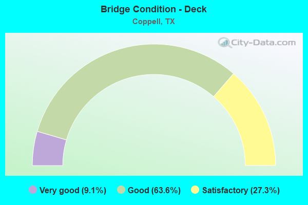
- Bridge Condition - Deck
- 9.1%Very good
- 63.6%Good
- 27.3%Satisfactory
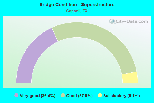
- Bridge Condition - Superstructure
- 36.4%Very good
- 57.6%Good
- 6.1%Satisfactory
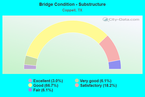
- Bridge Condition - Substructure
- 3.0%Excellent
- 6.1%Very good
- 66.7%Good
- 18.2%Satisfactory
- 6.1%Fair
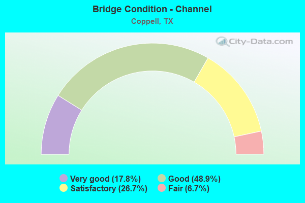
- Bridge Condition - Channel
- 17.8%Very good
- 48.9%Good
- 26.7%Satisfactory
- 6.7%Fair
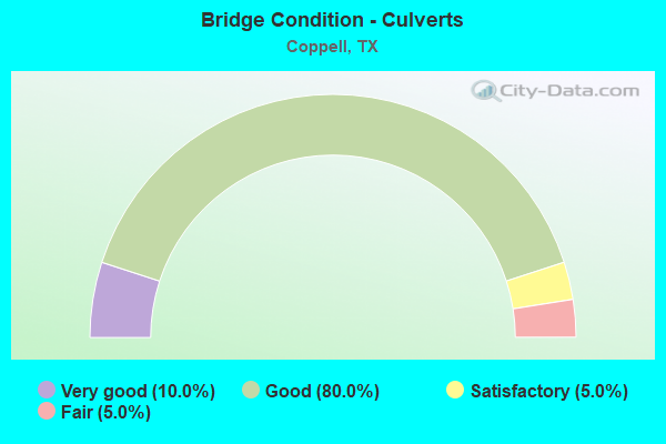
- Bridge Condition - Culverts
- 10.0%Very good
- 80.0%Good
- 5.0%Satisfactory
- 5.0%Fair
Find on map >> Show street view
Structure Number: 180570V00243003, Location: 1.82 MI E OF DENTON TAP (Lat: 32.974886, Lng: -96.963556), Route carried "on" structure: City street , Year Built: 1985, Status: Open, Structure Length: 1.16m (3.81ft), Average Daily Traffic: 2,916 (year 2015), Truck Traffic: 3%, Average Future Daily Traffic: 4,082 (year 2037), Design Load: HS 20, Features Intersected: DRAINAGE DITCH, Facility Carried by Structure: PARKWAY BLVD
Minimum Vertical Clearance: 30+ m (98+ ft), Kilometerpoint: 3.322, Lanes on structure: 4, Owner: City or Municipal Highway Agency, Approaching Roadway Width: 13.4m (44.0ft), Material/Design: Concrete, Design/Construction: Culvert, Number Of Spans In Main Unit: 4, Length of Maximum Span: 2.7m (8.9ft), Curb or Sidewalk Widths: Left: 1.2m (3.9ft), Right: 1.2m (3.9ft)
Condition: Channel: Very good, Culverts: Good, Operating Rating: 39.9 metric tons, Method Used To Determine Operating Rating: Load Factor (LF), Inventory Rating: 23.6 metric tons, Method Used To Determine Inventory Rating: Load Factor (LF), Structural Evaluation: Equal to present minimum criteria, Waterway Adequacy: Better than present minimum criteria, Approach Roadway Alignment: Equal to present desirable criteria, Designated Inspection Frequency: Every 24 months, Inspection Date: January 2021
Find on map >> Show street view
Structure Number: 180570V00243004, Location: 0.1 MI W OF DENTON TAP RD (Lat: 32.977567, Lng: -96.997153), Route carried "on" structure: City street , Year Built: 1990, Status: Open, Structure Length: 5.12m (16.80ft), Average Daily Traffic: 5,146 (year 2017), Truck Traffic: 4%, Average Future Daily Traffic: 7,210 (year 2037), Features Intersected: COTTONWOOD CREEK, Facility Carried by Structure: PARKWAY BLVD
Minimum Vertical Clearance: 30+ m (98+ ft), Kilometerpoint: 0.161, Lanes on structure: 4, Owner: City or Municipal Highway Agency, Approaching Roadway Width: 14.6m (47.9ft), Skew: 24 degrees, Material/Design: Prestressed concrete, Design/Construction: Stringer/Multi-beam, Number Of Spans In Main Unit: 2, Length of Maximum Span: 25.6m (84.0ft), Curb or Sidewalk Widths: Left: 2.1m (6.9ft), Right: 1.8m (5.9ft), Curb-To-Curb Width: 14.6m (47.9ft), Out-to-Out Width: 24.4m (80.1ft)
Condition: Deck: Good, Superstructure: Good, Substructure: Good, Channel: Satisfactory, Operating Rating: 32.7 metric tons, Method Used To Determine Operating Rating: Field evaluation and documented engineering judgment, Inventory Rating: 24.5 metric tons, Method Used To Determine Inventory Rating: Field evaluation and documented engineering judgment, Structural Evaluation: Equal to present minimum criteria, Deck Geometry: High priority of replacement, Waterway Adequacy: Equal to present minimum criteria, Approach Roadway Alignment: Equal to present desirable criteria, Length Of Structure Improvement: 5.12m (16.80ft), Designated Inspection Frequency: Every 24 months, Inspection Date: Febuary 2021, Bridge Improvement Cost: $16,000, Roadway Improvement Cost: $4,000, Total Project Cost: $20,000, Deck Structure Type: Concrete Cast-file-Place
Find on map >> Show street view
Structure Number: 180570V00253001, Location: 0.65 MI N OF BETHEL ROAD (Lat: 32.962439, Lng: -97.026556), Route carried "on" structure: City street , Year Built: 1986, Status: Open, Structure Length: 5.55m (18.21ft), Average Daily Traffic: 5,700 (year 2015), Truck Traffic: 30%, Average Future Daily Traffic: 7,980 (year 2037), Features Intersected: COTTONWOOD BRANCH, Facility Carried by Structure: ROYAL LANE NB
Minimum Vertical Clearance: 30+ m (98+ ft), Kilometerpoint: 1.287, Lanes on structure: 2, Owner: City or Municipal Highway Agency, Approaching Roadway Width: 7.3m (24.0ft), Material/Design: Concrete, Design/Construction: Stringer/Multi-beam, Number Of Spans In Main Unit: 6, Length of Maximum Span: 9.1m (29.9ft), Curb or Sidewalk Widths: Left: 1.0m (3.3ft), Right: 2.0m (6.6ft), Curb-To-Curb Width: 7.4m (24.3ft), Out-to-Out Width: 11.0m (36.1ft)
Condition: Deck: Good, Superstructure: Good, Substructure: Good, Channel: Satisfactory, Operating Rating: 32.7 metric tons, Method Used To Determine Operating Rating: Field evaluation and documented engineering judgment, Inventory Rating: 24.5 metric tons, Method Used To Determine Inventory Rating: Field evaluation and documented engineering judgment, Structural Evaluation: Equal to present minimum criteria, Deck Geometry: High priority of replacement, Waterway Adequacy: Better than present minimum criteria, Approach Roadway Alignment: Equal to present desirable criteria, Designated Inspection Frequency: Every 24 months, Inspection Date: Febuary 2021, Deck Structure Type: Concrete Cast-file-Place
Find on map >> Show street view
Structure Number: 180570V00253002, Location: 0.65 MI N OF BETHEL ROAD (Lat: 32.962928, Lng: -97.026794), Route carried "on" structure: City street , Year Built: 1986, Status: Open, Structure Length: 5.55m (18.21ft), Average Daily Traffic: 5,700 (year 2015), Truck Traffic: 3%, Average Future Daily Traffic: 7,980 (year 2037), Features Intersected: COTTONWOOD BRANCH, Facility Carried by Structure: ROYAL LANE SB
Minimum Vertical Clearance: 30+ m (98+ ft), Kilometerpoint: 1.287, Lanes on structure: 2, Owner: City or Municipal Highway Agency, Approaching Roadway Width: 7.3m (24.0ft), Material/Design: Concrete, Design/Construction: Stringer/Multi-beam, Number Of Spans In Main Unit: 6, Length of Maximum Span: 9.1m (29.9ft), Curb or Sidewalk Widths: Left: 1.9m (6.2ft), Right: 1.1m (3.6ft), Curb-To-Curb Width: 7.4m (24.3ft), Out-to-Out Width: 11.0m (36.1ft)
Condition: Deck: Good, Superstructure: Good, Substructure: Good, Channel: Good, Operating Rating: 32.7 metric tons, Method Used To Determine Operating Rating: Field evaluation and documented engineering judgment, Inventory Rating: 24.5 metric tons, Method Used To Determine Inventory Rating: Field evaluation and documented engineering judgment, Structural Evaluation: Equal to present minimum criteria, Deck Geometry: High priority of replacement, Waterway Adequacy: Better than present minimum criteria, Approach Roadway Alignment: Equal to present desirable criteria, Designated Inspection Frequency: Every 24 months, Inspection Date: Febuary 2021, Deck Structure Type: Concrete Cast-file-Place
Find on map >> Show street view
Structure Number: 180570V00253003, Location: 0.6 MI N OF IH 635 (Lat: 32.954603, Lng: -97.021933), Route carried "on" structure: City street , Year Built: 1998, Status: Open, Structure Length: 2.07m (6.79ft), Average Daily Traffic: 15,009 (year 2015), Truck Traffic: 3%, Average Future Daily Traffic: 21,012 (year 2037), Features Intersected: DRAINAGE DITCH, Facility Carried by Structure: ROYAL LANE
Minimum Vertical Clearance: 30+ m (98+ ft), Kilometerpoint: 3.621, Lanes on structure: 5, Owner: City or Municipal Highway Agency, Approaching Roadway Width: 18.3m (60.0ft), Skew: 20 degrees, Material/Design: Concrete, Design/Construction: Culvert, Number Of Spans In Main Unit: 8, Length of Maximum Span: 2.4m (7.9ft)
Condition: Channel: Satisfactory, Culverts: Fair, Operating Rating: 32.7 metric tons, Method Used To Determine Operating Rating: Field evaluation and documented engineering judgment, Inventory Rating: 24.5 metric tons, Method Used To Determine Inventory Rating: Field evaluation and documented engineering judgment, Structural Evaluation: Somewhat better than minimum adequacy, Waterway Adequacy: Better than present minimum criteria, Approach Roadway Alignment: Equal to present desirable criteria, Designated Inspection Frequency: Every 24 months, Inspection Date: Febuary 2021
Find on map >> Show street view
Structure Number: 180570V00254001, Location: At Intersection S Royal L (Lat: 32.950417, Lng: -97.022508), Route carried "on" structure: City street , Year Built: 2019, Status: Open, Structure Length: 1.07m (3.51ft), Average Daily Traffic: 5,000 (year 2019), Truck Traffic: 18%, Average Future Daily Traffic: 7,000 (year 2039), Features Intersected: Drain, Facility Carried by Structure: Technology Rd.
Minimum Vertical Clearance: 30+ m (98+ ft), Kilometerpoint: 0.000, Lanes on structure: 3, Owner: City or Municipal Highway Agency, Approaching Roadway Width: 14.6m (47.9ft), Skew: 9 degrees, Material/Design: Concrete, Design/Construction: Culvert, Number Of Spans In Main Unit: 4, Length of Maximum Span: 2.4m (7.9ft)
Condition: Channel: Very good, Culverts: Good, Operating Rating: 32.7 metric tons, Method Used To Determine Operating Rating: Field evaluation and documented engineering judgment, Inventory Rating: 24.5 metric tons, Method Used To Determine Inventory Rating: Field evaluation and documented engineering judgment, Structural Evaluation: Equal to present minimum criteria, Waterway Adequacy: Equal to present desirable criteria, Approach Roadway Alignment: Equal to present desirable criteria, Designated Inspection Frequency: Every 24 months, Inspection Date: March 2021, Wearing Surface/Protective System: Wearing Surface: Monolithic Concrete
Find on map >> Show street view
Structure Number: 180570V00275001, Location: 1.3 MI W of PGBT (Lat: 32.967681, Lng: -96.953164), Route carried "on" structure: City street , Year Built: 2001, Status: Open, Structure Length: 1.91m (6.27ft), Average Daily Traffic: 13,249 (year 2019), Truck Traffic: 3%, Average Future Daily Traffic: 18,548 (year 2039), Features Intersected: Trib. Denton Creek, Facility Carried by Structure: E. Sandy Lake Blvd
Minimum Vertical Clearance: 30+ m (98+ ft), Kilometerpoint: 2.092, Lanes on structure: 4, Owner: City or Municipal Highway Agency, Approaching Roadway Width: 15.9m (52.2ft), Skew: 34 degrees, Material/Design: Concrete, Design/Construction: Culvert, Number Of Spans In Main Unit: 4, Length of Maximum Span: 3.0m (9.8ft), Curb or Sidewalk Widths: Left: 1.8m (5.9ft), Right: 1.8m (5.9ft)
Condition: Channel: Good, Culverts: Very good, Operating Rating: 32.7 metric tons, Method Used To Determine Operating Rating: Field evaluation and documented engineering judgment, Inventory Rating: 24.5 metric tons, Method Used To Determine Inventory Rating: Field evaluation and documented engineering judgment, Structural Evaluation: Equal to present minimum criteria, Waterway Adequacy: Equal to present desirable criteria, Approach Roadway Alignment: Equal to present desirable criteria, Designated Inspection Frequency: Every 24 months, Inspection Date: March 2021, Wearing Surface/Protective System: Wearing Surface: Monolithic Concrete
Find on map >> Show street view
Structure Number: 180570V00300002, Location: 0.4 MI S OF SANDY LAKE RD (Lat: 32.967433, Lng: -97.015033), Route carried "on" structure: City street , Year Built: 2015, Status: Open, Structure Length: 5.49m (18.01ft), Average Daily Traffic: 5,054 (year 2015), Truck Traffic: 3%, Average Future Daily Traffic: 7,075 (year 2037), Design Load: HL 93, Features Intersected: COTTONWOOD BRANCH, Facility Carried by Structure: FREEPORT PKWY
Minimum Vertical Clearance: 30+ m (98+ ft), Kilometerpoint: 16.753, Lanes on structure: 4, Owner: City or Municipal Highway Agency, Approaching Roadway Width: 14.6m (47.9ft), Skew: 21 degrees, Material/Design: Prestressed concrete, Design/Construction: Box Beam or Girders - Multiple, Number Of Spans In Main Unit: 3, Length of Maximum Span: 21.3m (69.9ft), Curb or Sidewalk Widths: Left: 4.3m (14.1ft), Right: 2.1m (6.9ft), Curb-To-Curb Width: 14.6m (47.9ft), Out-to-Out Width: 28.3m (92.8ft)
Condition: Deck: Very good, Superstructure: Good, Substructure: Satisfactory, Channel: Satisfactory, Operating Rating: 54.4 metric tons, Method Used To Determine Operating Rating: Assigned ratings based on Load and Resistance Factor Design (LRFD) reported in metric tons, Inventory Rating: 32.7 metric tons, Method Used To Determine Inventory Rating: Assigned ratings based on Load and Resistance Factor Design (LRFD) reported in metric tons, Structural Evaluation: Equal to present minimum criteria, Deck Geometry: High priority of replacement, Waterway Adequacy: Superior to present desirable criteria, Approach Roadway Alignment: Equal to present desirable criteria, Designated Inspection Frequency: Every 24 months, Inspection Date: Febuary 2021, Deck Structure Type: Concrete Cast-file-Place
Find on map >> Show street view
Structure Number: 180570V00312001, Location: 0.2MI E OF MACRATHUR BLVD (Lat: 32.975022, Lng: -96.957514), Route carried "on" structure: City street , Year Built: 1986, Status: Open, Structure Length: 0.67m (2.20ft), Average Daily Traffic: 340 (year 2015), Truck Traffic: 3%, Average Future Daily Traffic: 340 (year 2037), Features Intersected: TRIB OF DENTON CREEK, Facility Carried by Structure: VILLAGE PKWY
Minimum Vertical Clearance: 30+ m (98+ ft), Kilometerpoint: 0.966, Lanes on structure: 2, Owner: City or Municipal Highway Agency, Approaching Roadway Width: 10.7m (35.1ft), Material/Design: Concrete, Design/Construction: Culvert, Number Of Spans In Main Unit: 2, Length of Maximum Span: 3.0m (9.8ft), Curb or Sidewalk Widths: Left: 1.2m (3.9ft), Right: 1.2m (3.9ft)
Condition: Channel: Very good, Culverts: Good, Operating Rating: 32.7 metric tons, Method Used To Determine Operating Rating: Field evaluation and documented engineering judgment, Inventory Rating: 24.5 metric tons, Method Used To Determine Inventory Rating: Field evaluation and documented engineering judgment, Structural Evaluation: Equal to present minimum criteria, Waterway Adequacy: Superior to present desirable criteria, Approach Roadway Alignment: Equal to present desirable criteria, Designated Inspection Frequency: Every 24 months, Inspection Date: January 2021
Find on map >> Show street view
Structure Number: 180570V00318001, Location: 0.1 MI E OF N COPPELL LN (Lat: 32.981122, Lng: -97.010636), Route carried "on" structure: City street , Year Built: 2002, Status: Open, Structure Length: 1.01m (3.31ft), Average Daily Traffic: 340 (year 2015), Truck Traffic: 3%, Average Future Daily Traffic: 340 (year 2037), Features Intersected: DRAW, Facility Carried by Structure: WESTMINSTER WAY
Minimum Vertical Clearance: 30+ m (98+ ft), Kilometerpoint: 0.161, Lanes on structure: 2, Owner: City or Municipal Highway Agency, Approaching Roadway Width: 8.2m (26.9ft), Skew: 1 degrees, Material/Design: Concrete, Design/Construction: Culvert, Number Of Spans In Main Unit: 3, Length of Maximum Span: 3.0m (9.8ft), Curb or Sidewalk Widths: Left: 1.1m (3.6ft), Right: 1.1m (3.6ft)
Condition: Channel: Good, Culverts: Satisfactory, Operating Rating: 32.7 metric tons, Method Used To Determine Operating Rating: Field evaluation and documented engineering judgment, Inventory Rating: 24.5 metric tons, Method Used To Determine Inventory Rating: Field evaluation and documented engineering judgment, Structural Evaluation: Equal to present minimum criteria, Waterway Adequacy: Better than present minimum criteria, Approach Roadway Alignment: Equal to present desirable criteria, Designated Inspection Frequency: Every 24 months, Inspection Date: Febuary 2021
Find on map >> Show street view
Structure Number: 180570V00328001, Location: 0.25 MI SE of SH 121 FR (Lat: 32.987156, Lng: -97.005092), Route carried "on" structure: City street , Year Built: 2015, Status: Open, Structure Length: 0.88m (2.89ft), Average Daily Traffic: 1,500 (year 2020), Truck Traffic: 1%, Average Future Daily Traffic: 2,000 (year 2040), Design Load: HL 93, Features Intersected: Denton Creek Trib, Facility Carried by Structure: Bridge St
Minimum Vertical Clearance: 30+ m (98+ ft), Kilometerpoint: 0.402, Lanes on structure: 2, Owner: City or Municipal Highway Agency, Approaching Roadway Width: 7.9m (25.9ft), Skew: 9 degrees, Material/Design: Concrete, Design/Construction: Culvert, Number Of Spans In Main Unit: 3, Length of Maximum Span: 2.4m (7.9ft), Curb or Sidewalk Widths: Left: 1.5m (4.9ft), Right: 1.5m (4.9ft)
Condition: Channel: Fair, Culverts: Good, Operating Rating: 54.4 metric tons, Method Used To Determine Operating Rating: Assigned ratings based on Load and Resistance Factor Design (LRFD) reported in metric tons, Inventory Rating: 32.7 metric tons, Method Used To Determine Inventory Rating: Assigned ratings based on Load and Resistance Factor Design (LRFD) reported in metric tons, Structural Evaluation: Better than present minimum criteria, Waterway Adequacy: Superior to present desirable criteria, Approach Roadway Alignment: Equal to present desirable criteria, Designated Inspection Frequency: Every 24 months, Inspection Date: October 2020
Find on map >> Show street view
Structure Number: 180570V00328002, Location: 0.05 MI NE of Bridge St (Lat: 32.987731, Lng: -97.005286), Route carried "on" structure: City street , Year Built: 2015, Status: Open, Structure Length: 1.04m (3.41ft), Average Daily Traffic: 400 (year 2020), Average Future Daily Traffic: 600 (year 2040), Design Load: HL 93, Features Intersected: Denton Creek Trib, Facility Carried by Structure: Evergreen Dr
Minimum Vertical Clearance: 30+ m (98+ ft), Kilometerpoint: 0.080, Lanes on structure: 2, Owner: City or Municipal Highway Agency, Approaching Roadway Width: 7.9m (25.9ft), Skew: 3 degrees, Material/Design: Concrete, Design/Construction: Culvert, Number Of Spans In Main Unit: 3, Length of Maximum Span: 2.4m (7.9ft), Curb or Sidewalk Widths: Left: 1.5m (4.9ft), Right: 1.5m (4.9ft), Curb-To-Curb Width: 8.1m (26.6ft), Out-to-Out Width: 18.7m (61.4ft)
Condition: Channel: Fair, Culverts: Good, Operating Rating: 54.4 metric tons, Method Used To Determine Operating Rating: Assigned ratings based on Load and Resistance Factor Design (LRFD) reported in metric tons, Inventory Rating: 32.7 metric tons, Method Used To Determine Inventory Rating: Assigned ratings based on Load and Resistance Factor Design (LRFD) reported in metric tons, Structural Evaluation: Better than present minimum criteria, Deck Geometry: Somewhat better than minimum adequacy, Waterway Adequacy: Superior to present desirable criteria, Approach Roadway Alignment: Equal to present desirable criteria, Designated Inspection Frequency: Every 24 months, Inspection Date: October 2020, Deck Structure Type: Concrete Cast-file-Place, Wearing Surface/Protective System: Wearing Surface: Monolithic Concrete
Find on map >> Show street view
Structure Number: 180610354701454, Location: 0.10 MI NE OF DALLAS C/L (Lat: 32.990056, Lng: -97.008164), Route carried "on" structure: Other road 121, Year Built: 2006, Status: Open, Structure Length: 10.12m (33.20ft), Average Daily Traffic: 7,500 (year 2008), Truck Traffic: 5%, Average Future Daily Traffic: 10,000 (year 2028), Design Load: HS 20, Features Intersected: SH 121 TOLL
Minimum Vertical Clearance: 30+ m (98+ ft), Kilometerpoint: 10.670, Lanes on structure: 2, Lanes under structure: 5, Toll: On toll road, Owner: Local Toll Authority, Approaching Roadway Width: 11.0m (36.1ft), Skew: 9 degrees, Material/Design: Steel continuous, Design/Construction: Stringer/Multi-beam, Number Of Spans In Main Unit: 2, Length of Maximum Span: 57.6m (189.0ft), Curb-To-Curb Width: 11.0m (36.1ft), Out-to-Out Width: 11.6m (38.1ft)
Condition: Deck: Good, Superstructure: Very good, Substructure: Good, Operating Rating: 48.1 metric tons, Method Used To Determine Operating Rating: Load Factor (LF), Inventory Rating: 29.0 metric tons, Method Used To Determine Inventory Rating: Load Factor (LF), Structural Evaluation: Better than present minimum criteria, Deck Geometry: Equal to present minimum criteria, Underclear: Equal to present minimum criteria, Approach Roadway Alignment: Equal to present desirable criteria, Designated Inspection Frequency: Every 24 months, Inspection Date: November 2021, Deck Structure Type: Concrete Cast-file-Place, Wearing Surface/Protective System: Deck Protection: Epoxy Coated Reinforcing
Find on map >> Show street view
Structure Number: 180570036402617, Location: 1.5 MI NE OF IH 635 (Lat: 32.972850, Lng: -97.028439), Route carried "under" structure: City street , Year Built: 2017, Structure Length: 0. m, Average Daily Traffic: 4,000 (year 2010), Features Intersected: W. Sandy Lake Rd., Facility Carried by Structure: SH 121 NB
Minimum Vertical Clearance: 5.26m (17.26ft), Lanes on structure: 4, Lanes under structure: 10, Material/Design: Prestressed concrete, Design/Construction: Stringer/Multi-beam, Length of Maximum Span: 38.4m (126.0ft)
Find on map >> Show street view
Structure Number: 180570036402618, Location: 3.5 MI NE of IH 635 (Lat: 32.980039, Lng: -97.020750), Route carried "under" structure: City street , Year Built: 2017, Structure Length: 0. m, Average Daily Traffic: 2,000 (year 2010), Features Intersected: Freeport Pkwy., Facility Carried by Structure: SH 121 NB
Minimum Vertical Clearance: 6.04m (19.82ft), Lanes on structure: 5, Lanes under structure: 10, Material/Design: Prestressed concrete, Design/Construction: Stringer/Multi-beam, Length of Maximum Span: 36.6m (120.1ft)
Find on map >> Show street view
Structure Number: 18057003640262, Location: 2.0 MI NE OF IH 635 (Lat: 32.975839, Lng: -97.024719), Route carried "under" structure: Ramp State highway 121, Year Built: 2015, Structure Length: 0. m, Average Daily Traffic: 5,000 (year 2020), Features Intersected: SH 121 NB Off-Ramp
Minimum Vertical Clearance: 5.79m (19.00ft), Lanes on structure: 1, Lanes under structure: 1, Material/Design: Prestressed concrete, Design/Construction: Stringer/Multi-beam, Length of Maximum Span: 36.6m (120.1ft)
Find on map >> Show street view
Structure Number: 180570237407343, Location: 8.3 MI W OF IH 35E (Lat: 32.947256, Lng: -96.028242), Route carried "under" structure: Alternate City street , Year Built: 1979, Structure Length: 0. m, Average Daily Traffic: 231 (year 2020), Features Intersected: IH 635 EB, Facility Carried by Structure: IH 635 EB
Minimum Vertical Clearance: 6.88m (22.57ft), Kilometerpoint: 0.000, Lanes on structure: 4, Lanes under structure: 2, Material/Design: Prestressed concrete, Design/Construction: Stringer/Multi-beam, Length of Maximum Span: 25.9m (85.0ft)
Find on map >> Show street view
Structure Number: 180570237407344, Location: 8.3 MI W OF IH 35E (Lat: 32.947542, Lng: -97.027542), Route carried "under" structure: Alternate City street , Year Built: 1979, Structure Length: 0. m, Average Daily Traffic: 231 (year 2020), Truck Traffic: 3%, Features Intersected: IH 635 WB, Facility Carried by Structure: IH 635 WB
Minimum Vertical Clearance: 7.47m (24.51ft), Kilometerpoint: 0.000, Lanes on structure: 6, Lanes under structure: 2, Material/Design: Prestressed concrete, Design/Construction: Stringer/Multi-beam, Length of Maximum Span: 25.9m (85.0ft)
Find on map >> Show street view
Structure Number: 180570237407345, Location: 8.0 MI W OF IH 35E (Lat: 32.945514, Lng: -96.022228), Route carried "under" structure: State highway , Year Built: 1979, Structure Length: 0. m, Average Daily Traffic: 20,365 (year 2019), Truck Traffic: 18%, Features Intersected: IH 635 EB, Facility Carried by Structure: IH 635 EB
Minimum Vertical Clearance: 5.23m (17.16ft), Kilometerpoint: 136.751, Lanes on structure: 4, Lanes under structure: 4, Material/Design: Prestressed concrete, Design/Construction: Stringer/Multi-beam, Length of Maximum Span: 38.1m (125.0ft)
Find on map >> Show street view
Structure Number: 180570237407346, Location: 8.0 MI W OF IH 35E (Lat: 32.945914, Lng: -97.022364), Route carried "under" structure: City street , Year Built: 1979, Structure Length: 0. m, Average Daily Traffic: 15,613 (year 2011), Truck Traffic: 3%, Features Intersected: IH 635 WB, Facility Carried by Structure: IH 635 WB
Minimum Vertical Clearance: 5.05m (16.57ft), Kilometerpoint: 39.812, Lanes on structure: 4, Lanes under structure: 4, Material/Design: Prestressed concrete, Design/Construction: Stringer/Multi-beam, Length of Maximum Span: 38.1m (125.0ft)
Find on map >> Show street view
Structure Number: 180610354701454, Location: 0.10 MI NE OF DALLAS C/L (Lat: 32.990000, Lng: -97.008200), Route carried "under" structure: Other road 121, Year Built: 2006, Structure Length: 0. m, Average Daily Traffic: 36,000 (year 2013), Truck Traffic: 5%, Features Intersected: SH 121 TOLL
Minimum Vertical Clearance: 5.49m (18.01ft), Kilometerpoint: 21.726, Toll: On toll road, Material/Design: Steel continuous, Design/Construction: Stringer/Multi-beam, Length of Maximum Span: 57.6m (189.0ft)