Bridge Statistics for Coon Rapids, Minnesota (MN)
Condition, Traffic, Stress, Structural Evaluation, Project Costs
- National Bridge Inventory (NBI) Statistics
- 70Number of bridges
- 794ft / 242mTotal length
- $2,223,001,000Total costs
- 2,085,169Total average daily traffic
- 58,159Total average daily truck traffic
- National Bridge Inventory (NBI) Registered Bridges for Coon Rapids
- No street view available for this location
- New bridges - historical statistics
- 61960-1969
- 51970-1979
- 121980-1989
- 321990-1999
- 92000-2009
- 62010-2019
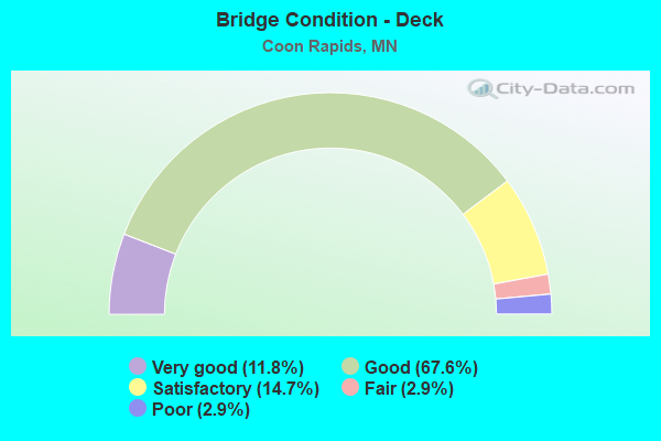
- Bridge Condition - Deck
- 11.8%Very good
- 67.6%Good
- 14.7%Satisfactory
- 2.9%Fair
- 2.9%Poor
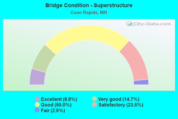
- Bridge Condition - Superstructure
- 8.8%Excellent
- 14.7%Very good
- 50.0%Good
- 23.5%Satisfactory
- 2.9%Fair
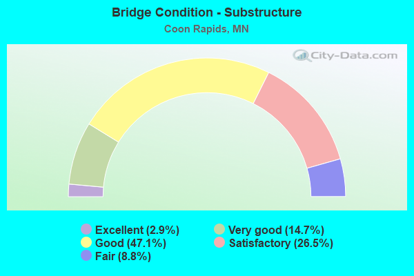
- Bridge Condition - Substructure
- 2.9%Excellent
- 14.7%Very good
- 47.1%Good
- 26.5%Satisfactory
- 8.8%Fair
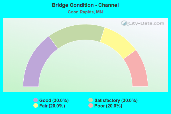
- Bridge Condition - Channel
- 30.0%Good
- 30.0%Satisfactory
- 20.0%Fair
- 20.0%Poor
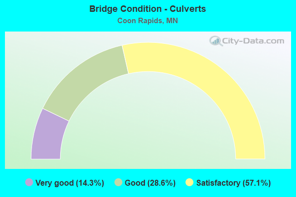
- Bridge Condition - Culverts
- 14.3%Very good
- 28.6%Good
- 57.1%Satisfactory
Find on map >> Show street view
Structure Number: 2023, Location: 1.1 MI SW OF JCT TH 10 (Lat: 45.138742, Lng: -93.290597), Route carried "under" structure: County highway 1, Year Built: 1986, Structure Length: 0. m, Average Daily Traffic: 17,600 (year 2005), Features Intersected: East River Road
Minimum Vertical Clearance: 5.00m (16.40ft), Kilometerpoint: 0.000, Lanes on structure: 3, Lanes under structure: 6, Material/Design: Prestressed concrete, Design/Construction: Stringer/Multi-beam, Length of Maximum Span: 29.0m (95.1ft)
Find on map >> Show street view
Structure Number: 2024, Location: 1.1 MI SW OF JCT TH 10 (Lat: 45.138550, Lng: -93.290489), Route carried "under" structure: County highway 1, Year Built: 1986, Structure Length: 0. m, Average Daily Traffic: 17,600 (year 2005), Features Intersected: East River Road
Minimum Vertical Clearance: 5.00m (16.40ft), Kilometerpoint: 0.000, Lanes on structure: 3, Lanes under structure: 6, Material/Design: Prestressed concrete, Design/Construction: Stringer/Multi-beam, Length of Maximum Span: 29.0m (95.1ft)
Find on map >> Show street view
Structure Number: 2027, Location: 0.4 MI SW OF JCT TH 10 (Lat: 45.142833, Lng: -93.279336), Route carried "under" structure: City street 116, Year Built: 1986, Structure Length: 0. m, Average Daily Traffic: 24,700 (year 2005), Features Intersected: Coon Rapids Blvd, Facility Carried by Structure: MN 610
Minimum Vertical Clearance: 5.00m (16.40ft), Kilometerpoint: 0.000, Lanes on structure: 4, Lanes under structure: 4, Material/Design: Prestressed concrete, Design/Construction: Stringer/Multi-beam, Length of Maximum Span: 31.0m (101.7ft)
Find on map >> Show street view
Structure Number: 2028, Location: 0.4 MI SW OF JCT TH 10 (Lat: 45.142594, Lng: -93.279103), Route carried "under" structure: City street 116, Year Built: 1986, Structure Length: 0. m, Average Daily Traffic: 24,700 (year 2005), Features Intersected: Coon Rapids Blvd, Facility Carried by Structure: MN 610
Minimum Vertical Clearance: 5.00m (16.40ft), Kilometerpoint: 0.000, Lanes on structure: 3, Lanes under structure: 4, Material/Design: Prestressed concrete, Design/Construction: Stringer/Multi-beam, Length of Maximum Span: 31.0m (101.7ft)
Find on map >> Show street view
Structure Number: 2031, Location: 3.6 MI SE OF JCT TH 242 (Lat: 45.163300, Lng: -93.285386), Route carried "under" structure: US 10, Year Built: 1997, Structure Length: 0. m, Average Daily Traffic: 102,000 (year 2019), Truck Traffic: 3%, Features Intersected: US 10
Minimum Vertical Clearance: 5.00m (16.40ft), Kilometerpoint: 0.000, Lanes on structure: 4, Lanes under structure: 7, Material/Design: Prestressed concrete, Design/Construction: Stringer/Multi-beam, Length of Maximum Span: 30.0m (98.4ft)
Find on map >> Show street view
Structure Number: 2033, Location: 0.5 MI N OF JCT TH 610 (Lat: 45.152247, Lng: -93.274475), Route carried "under" structure: US 10, Year Built: 1996, Structure Length: 0. m, Average Daily Traffic: 102,000 (year 2019), Truck Traffic: 3%, Features Intersected: US 10, RAMP; MN 47, Facility Carried by Structure: CSAH 11
Minimum Vertical Clearance: 5.00m (16.40ft), Kilometerpoint: 0.000, Lanes on structure: 5, Lanes under structure: 6, Material/Design: Steel continuous, Design/Construction: Stringer/Multi-beam, Length of Maximum Span: 52.0m (170.6ft)
Find on map >> Show street view
Structure Number: 2033, Location: 0.5 MI N OF JCT TH 610 (Lat: 45.152247, Lng: -93.274475), Route carried "under" structure: Ramp US 5887, Year Built: 1996, Structure Length: 0. m, Average Daily Traffic: 5,000 (year 1994), Features Intersected: US 10, RAMP; MN 47, Facility Carried by Structure: CSAH 11
Minimum Vertical Clearance: 5.00m (16.40ft), Kilometerpoint: 0.000, Lanes on structure: 5, Lanes under structure: 2, Material/Design: Steel continuous, Design/Construction: Stringer/Multi-beam, Length of Maximum Span: 52.0m (170.6ft)
Find on map >> Show street view
Structure Number: 2033, Location: 0.5 MI N OF JCT TH 610 (Lat: 45.152247, Lng: -93.274475), Route carried "under" structure: State highway 47, Year Built: 1996, Structure Length: 0. m, Average Daily Traffic: 23,250 (year 2008), Truck Traffic: 5%, Features Intersected: US 10, RAMP; MN 47, Facility Carried by Structure: CSAH 11
Minimum Vertical Clearance: 5.00m (16.40ft), Kilometerpoint: 0.000, Lanes on structure: 5, Lanes under structure: 3, Material/Design: Steel continuous, Design/Construction: Stringer/Multi-beam, Length of Maximum Span: 52.0m (170.6ft)
Find on map >> Show street view
Structure Number: 2034, Location: 0.5 MI N OF JCT TH 610 (Lat: 45.150725, Lng: -93.273675), Route carried "under" structure: State highway 47, Year Built: 1996, Structure Length: 0. m, Average Daily Traffic: 23,250 (year 2008), Truck Traffic: 5%, Features Intersected: MN 47 SB, Facility Carried by Structure: CON 5529
Minimum Vertical Clearance: 5.00m (16.40ft), Kilometerpoint: 0.000, Lanes on structure: 3, Lanes under structure: 3, Material/Design: Prestressed concrete, Design/Construction: Box Beam or Girders - Multiple, Length of Maximum Span: 47.0m (154.2ft)
Find on map >> Show street view
Structure Number: 2035, Location: AT THE JCT TH 47 (Lat: 45.146300, Lng: -93.269950), Route carried "under" structure: State highway 47, Year Built: 1997, Structure Length: 0. m, Average Daily Traffic: 25,000 (year 2019), Truck Traffic: 3%, Features Intersected: MN 47 NB, Facility Carried by Structure: US 10
Minimum Vertical Clearance: 5.49m (18.01ft), Kilometerpoint: 0.000, Lanes on structure: 6, Lanes under structure: 3, Material/Design: Steel continuous, Design/Construction: Stringer/Multi-beam, Length of Maximum Span: 66.0m (216.5ft)
Find on map >> Show street view
Structure Number: 2037E, Location: 0.1 MI W OF JCT TH 47 (Lat: 45.143475, Lng: -93.266731), Route carried "under" structure: State highway 610, Year Built: 1997, Structure Length: 0. m, Average Daily Traffic: 27,500 (year 2004), Truck Traffic: 4%, Features Intersected: UNIVERSITY AVE; MN 610, Facility Carried by Structure: US 10
Minimum Vertical Clearance: 4.97m (16.31ft), Kilometerpoint: 0.000, Lanes on structure: 2, Lanes under structure: 3, Material/Design: Prestressed concrete, Design/Construction: Box Beam or Girders - Multiple, Length of Maximum Span: 62.0m (203.4ft)
Find on map >> Show street view
Structure Number: 2037E, Location: 0.1 MI W OF JCT TH 47 (Lat: 45.143475, Lng: -93.266731), Route carried "under" structure: County highway 51, Year Built: 1997, Structure Length: 0. m, Average Daily Traffic: 23,000 (year 2005), Features Intersected: UNIVERSITY AVE; MN 610, Facility Carried by Structure: US 10
Minimum Vertical Clearance: 5.00m (16.40ft), Kilometerpoint: 0.000, Lanes on structure: 2, Lanes under structure: 4, Material/Design: Prestressed concrete, Design/Construction: Box Beam or Girders - Multiple, Length of Maximum Span: 62.0m (203.4ft)
Find on map >> Show street view
Structure Number: 2037E, Location: 0.1 MI W OF JCT TH 47 (Lat: 45.143475, Lng: -93.266731), Route carried "under" structure: Ramp US 4875, Year Built: 1997, Structure Length: 0. m, Average Daily Traffic: 1 (year 2019), Features Intersected: UNIVERSITY AVE; MN 610, Facility Carried by Structure: US 10
Minimum Vertical Clearance: 4.88m (16.01ft), Kilometerpoint: 0.000, Lanes under structure: 1, Material/Design: Prestressed concrete, Design/Construction: Box Beam or Girders - Multiple, Length of Maximum Span: 62.0m (203.4ft)
Find on map >> Show street view
Structure Number: 2037W, Location: 0.1 MI E OF JCT TH 47 (Lat: 45.143489, Lng: -93.266472), Route carried "under" structure: State highway 610, Year Built: 1997, Structure Length: 0. m, Average Daily Traffic: 27,500 (year 2004), Truck Traffic: 4%, Features Intersected: UNIVERSITY AVE; MN 610, Facility Carried by Structure: US 10
Minimum Vertical Clearance: 5.00m (16.40ft), Kilometerpoint: 0.000, Lanes on structure: 3, Lanes under structure: 3, Material/Design: Prestressed concrete, Design/Construction: Box Beam or Girders - Multiple, Length of Maximum Span: 65.0m (213.3ft)
Find on map >> Show street view
Structure Number: 2037W, Location: 0.1 MI E OF JCT TH 47 (Lat: 45.143489, Lng: -93.266472), Route carried "under" structure: County highway 51, Year Built: 1997, Structure Length: 0. m, Average Daily Traffic: 23,000 (year 2005), Features Intersected: UNIVERSITY AVE; MN 610, Facility Carried by Structure: US 10
Minimum Vertical Clearance: 5.00m (16.40ft), Kilometerpoint: 0.000, Lanes on structure: 3, Lanes under structure: 4, Material/Design: Prestressed concrete, Design/Construction: Box Beam or Girders - Multiple, Length of Maximum Span: 65.0m (213.3ft)
Find on map >> Show street view
Structure Number: 2037W, Location: 0.1 MI E OF JCT TH 47 (Lat: 45.143489, Lng: -93.266472), Route carried "under" structure: Ramp US 4875, Year Built: 1997, Structure Length: 0. m, Average Daily Traffic: 1 (year 2019), Features Intersected: UNIVERSITY AVE; MN 610, Facility Carried by Structure: US 10
Minimum Vertical Clearance: 4.88m (16.01ft), Kilometerpoint: 0.000, Lanes under structure: 1, Material/Design: Prestressed concrete, Design/Construction: Box Beam or Girders - Multiple, Length of Maximum Span: 65.0m (213.3ft)
Find on map >> Show street view
Structure Number: 2039, Location: 0.1 MI E OF JCT TH 47 (Lat: 45.143314, Lng: -93.266961), Route carried "under" structure: County highway 51, Year Built: 1997, Structure Length: 0. m, Average Daily Traffic: 17,100 (year 2005), Features Intersected: University Avenue, Facility Carried by Structure: MN 610
Minimum Vertical Clearance: 5.00m (16.40ft), Kilometerpoint: 0.000, Lanes on structure: 3, Lanes under structure: 4, Material/Design: Prestressed concrete, Design/Construction: Stringer/Multi-beam, Length of Maximum Span: 25.0m (82.0ft)
Find on map >> Show street view
Structure Number: 204, Location: 0.1 MI E OF JCT TH 47 (Lat: 45.142311, Lng: -93.266547), Route carried "under" structure: County highway 51, Year Built: 1997, Structure Length: 0. m, Average Daily Traffic: 17,100 (year 2005), Features Intersected: University Avenue, Facility Carried by Structure: MN 610
Minimum Vertical Clearance: 5.00m (16.40ft), Kilometerpoint: 0.000, Lanes on structure: 4, Lanes under structure: 5, Material/Design: Prestressed concrete, Design/Construction: Stringer/Multi-beam, Length of Maximum Span: 26.0m (85.3ft)
Find on map >> Show street view
Structure Number: 2041, Location: AT THE JCT TH 47 (Lat: 45.143017, Lng: -93.270142), Route carried "under" structure: State highway 47, Year Built: 1997, Structure Length: 0. m, Average Daily Traffic: 50,000 (year 2019), Truck Traffic: 3%, Features Intersected: MN 47, Facility Carried by Structure: MN 610
Minimum Vertical Clearance: 5.97m (19.59ft), Kilometerpoint: 0.000, Lanes on structure: 3, Lanes under structure: 5, Material/Design: Prestressed concrete, Design/Construction: Stringer/Multi-beam, Length of Maximum Span: 35.0m (114.8ft)
Find on map >> Show street view
Structure Number: 2042, Location: AT THE JCT TH 47 (Lat: 45.142553, Lng: -93.270150), Route carried "under" structure: State highway 47, Year Built: 1997, Structure Length: 0. m, Average Daily Traffic: 50,000 (year 2019), Truck Traffic: 3%, Features Intersected: MN 47, Facility Carried by Structure: MN 610
Minimum Vertical Clearance: 5.00m (16.40ft), Kilometerpoint: 0.000, Lanes on structure: 4, Lanes under structure: 5, Material/Design: Prestressed concrete, Design/Construction: Stringer/Multi-beam, Length of Maximum Span: 34.0m (111.5ft)
Find on map >> Show street view
Structure Number: 2522, Location: AT THE JCT CR 3 (Lat: 45.147525, Lng: -93.293533), Route carried "under" structure: County highway 1, Year Built: 1972, Structure Length: 0. m, Average Daily Traffic: 30,231 (year 2007), Features Intersected: NB EAST RIVER RD(CSAH 1)
Minimum Vertical Clearance: 5.24m (17.19ft), Kilometerpoint: 0.000, Lanes on structure: 4, Lanes under structure: 2, Material/Design: Prestressed concrete, Design/Construction: Stringer/Multi-beam, Length of Maximum Span: 27.1m (88.9ft)
Find on map >> Show street view
Structure Number: 2552, Location: 0.8 MI NW OF JCT TH 242 (Lat: 45.204328, Lng: -93.357819), Route carried "under" structure: US 10, Year Built: 1989, Structure Length: 0. m, Average Daily Traffic: 70,000 (year 2019), Truck Traffic: 3%, Features Intersected: US 10, Facility Carried by Structure: CSAH 9
Minimum Vertical Clearance: 5.33m (17.49ft), Kilometerpoint: 0.000, Lanes on structure: 6, Lanes under structure: 6, Material/Design: Prestressed concrete, Design/Construction: Stringer/Multi-beam, Length of Maximum Span: 26.2m (86.0ft)
Find on map >> Show street view
Structure Number: 2559, Location: 0.85 MI E JCT US10-CSAH9 (Lat: 45.197619, Lng: -93.340600), Route carried "under" structure: US 10, Year Built: 2000, Structure Length: 0. m, Average Daily Traffic: 76,000 (year 2019), Truck Traffic: 3%, Features Intersected: US 10, Facility Carried by Structure: CSAH 14
Minimum Vertical Clearance: 5.06m (16.60ft), Kilometerpoint: 0.000, Lanes on structure: 6, Lanes under structure: 6, Material/Design: Prestressed concrete, Design/Construction: Stringer/Multi-beam, Length of Maximum Span: 36.5m (119.8ft)
Find on map >> Show street view
Structure Number: 2562, Location: 2.4 MI SE OF JCT TH 242 (Lat: 45.175664, Lng: -93.302681), Route carried "under" structure: US 10, Year Built: 1998, Structure Length: 0. m, Average Daily Traffic: 102,000 (year 2019), Truck Traffic: 3%, Features Intersected: US 10, Facility Carried by Structure: MSAS 120
Minimum Vertical Clearance: 4.91m (16.11ft), Kilometerpoint: 0.000, Lanes on structure: 4, Lanes under structure: 4, Material/Design: Prestressed concrete, Design/Construction: Stringer/Multi-beam, Length of Maximum Span: 29.7m (97.4ft)
Find on map >> Show street view
Structure Number: 2567, Location: 1.7 MI SE JCT TH 242 (Lat: 45.181961, Lng: -93.315353), Route carried "under" structure: US 10, Year Built: 2007, Structure Length: 0. m, Average Daily Traffic: 102,000 (year 2019), Truck Traffic: 3%, Features Intersected: US 10, Facility Carried by Structure: CSAH 11
Minimum Vertical Clearance: 5.00m (16.40ft), Kilometerpoint: 0.000, Lanes on structure: 6, Lanes under structure: 4, Material/Design: Steel continuous, Design/Construction: Stringer/Multi-beam, Length of Maximum Span: 27.7m (90.9ft)
Find on map >> Show street view
Structure Number: 257, Location: 0.42 MI NW JCT MN 242 (Lat: 45.202758, Lng: -93.347603), Route carried "under" structure: US 10, Year Built: 2006, Structure Length: 0. m, Average Daily Traffic: 70,000 (year 2019), Truck Traffic: 3%, Features Intersected: US 10, Facility Carried by Structure: MSAS 127
Minimum Vertical Clearance: 5.21m (17.09ft), Kilometerpoint: 0.000, Lanes on structure: 4, Lanes under structure: 4, Material/Design: Prestressed concrete, Design/Construction: Stringer/Multi-beam, Length of Maximum Span: 44.6m (146.3ft)
Find on map >> Show street view
Structure Number: 2588, Location: 1.1 MI S OF JCT TH 10 (Lat: 45.165000, Lng: -93.317800), Route carried "under" structure: City street 552, Year Built: 2019, Structure Length: 0. m, Average Daily Traffic: 1 (year 2018), Features Intersected: 108TH AVE NW, Facility Carried by Structure: CSAH 78
Minimum Vertical Clearance: 5.06m (16.60ft), Kilometerpoint: 0.000, Lanes under structure: 2, Material/Design: Prestressed concrete, Design/Construction: Stringer/Multi-beam, Length of Maximum Span: 22.1m (72.5ft)
Find on map >> Show street view
Structure Number: 9725, Location: 0.4 Mi South of Jct TH 6 (Lat: 45.135928, Lng: -93.270425), Route carried "under" structure: County highway 10, Year Built: 1966, Structure Length: 0. m, Average Daily Traffic: 16,900 (year 2007), Features Intersected: CSAH 10, Facility Carried by Structure: MN 47
Minimum Vertical Clearance: 4.94m (16.21ft), Kilometerpoint: 0.000, Lanes on structure: 2, Lanes under structure: 4, Material/Design: Steel continuous, Design/Construction: Stringer/Multi-beam, Length of Maximum Span: 20.2m (66.3ft)
Find on map >> Show street view
Structure Number: 9726, Location: 0.4 Mi South of Jct TH 6 (Lat: 45.135678, Lng: -93.270111), Route carried "under" structure: County highway 10, Year Built: 1966, Structure Length: 0. m, Average Daily Traffic: 16,900 (year 2007), Features Intersected: CSAH 10, Facility Carried by Structure: MN 47
Minimum Vertical Clearance: 5.00m (16.40ft), Kilometerpoint: 0.000, Lanes on structure: 2, Lanes under structure: 4, Material/Design: Steel continuous, Design/Construction: Stringer/Multi-beam, Length of Maximum Span: 20.2m (66.3ft)