Bridge Statistics for Compton, California (CA)
Condition, Traffic, Stress, Structural Evaluation, Project Costs
- National Bridge Inventory (NBI) Statistics
- 65Number of bridges
- 1,135ft / 346mTotal length
- $79,452,000Total costs
- 3,384,538Total average daily traffic
- 235,193Total average daily truck traffic
- National Bridge Inventory (NBI) Registered Bridges for Compton
- No street view available for this location
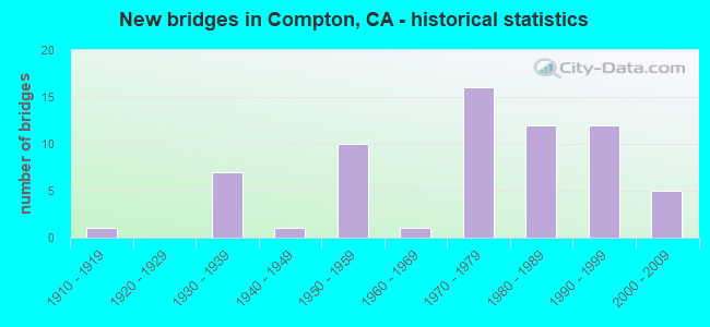
- New bridges - historical statistics
- 11910-1919
- 71930-1939
- 11940-1949
- 101950-1959
- 11960-1969
- 161970-1979
- 121980-1989
- 121990-1999
- 52000-2009
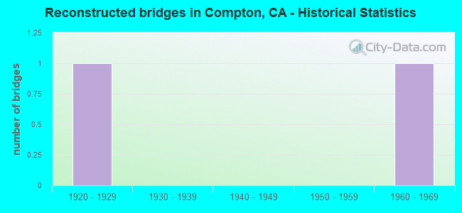
- Reconstructed bridges - Historical Statistics
- 11920-1929
- 01930-1939
- 01940-1949
- 01950-1959
- 11960-1969
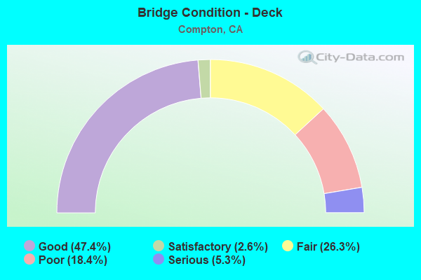
- Bridge Condition - Deck
- 47.4%Good
- 2.6%Satisfactory
- 26.3%Fair
- 18.4%Poor
- 5.3%Serious
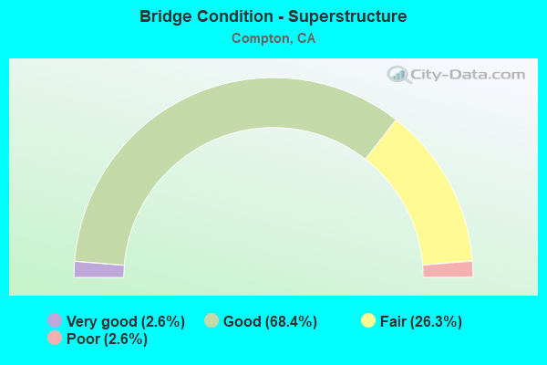
- Bridge Condition - Superstructure
- 2.6%Very good
- 68.4%Good
- 26.3%Fair
- 2.6%Poor
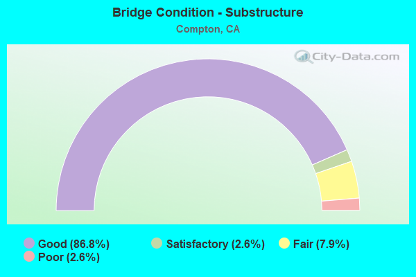
- Bridge Condition - Substructure
- 86.8%Good
- 2.6%Satisfactory
- 7.9%Fair
- 2.6%Poor
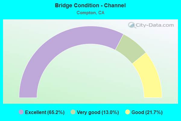
- Bridge Condition - Channel
- 65.2%Excellent
- 13.0%Very good
- 21.7%Good
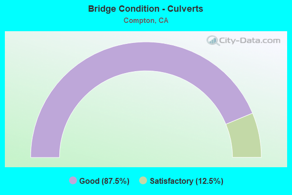
- Bridge Condition - Culverts
- 87.5%Good
- 12.5%Satisfactory
Find on map >> Show street view
Structure Number: 53 0821, Location: 07-LA-710-13.62-COM (Lat: 33.884489, Lng: -118.190544), Route carried "on" structure: Interstate 710, Year Built: 1954, Year Reconstructed: 1971, Status: Open, Structure Length: 3.17m (10.40ft), Average Daily Traffic: 230,000 (year 2017), Truck Traffic: 14%, Average Future Daily Traffic: 253,395 (year 2037), Design Load: HS 20, Features Intersected: ATLANTIC AVE
Minimum Vertical Clearance: 30+ m (98+ ft), Kilometerpoint: 13.620, Lanes on structure: 12, Lanes under structure: 4, Base Highway Network: Yes (Inventory Route: 7, Subroute: 1), Owner: State Highway Agency, Approaching Roadway Width: 53.9m (176.8ft), Skew: 32 degrees, Material/Design: Concrete, Design/Construction: Tee Beam, Number Of Spans In Main Unit: 1, Length of Maximum Span: 30.5m (100.1ft), Curb-To-Curb Width: 53.9m (176.8ft), Out-to-Out Width: 58.4m (191.6ft)
Condition: Deck: Good, Superstructure: Good, Substructure: Good, Operating Rating: 96.6 metric tons, Method Used To Determine Operating Rating: Load Factor (LF), Inventory Rating: 32.4 metric tons, Method Used To Determine Inventory Rating: Load Factor (LF), Structural Evaluation: Better than present minimum criteria, Deck Geometry: Superior to present desirable criteria, Underclear: Equal to present minimum criteria, Approach Roadway Alignment: Equal to present desirable criteria, Designated Inspection Frequency: Every 24 months, Inspection Date: May 2020, Deck Structure Type: Concrete Cast-file-Place
Find on map >> Show street view
Structure Number: 53 0822, Location: 07-LA-710-13.95-COM (Lat: 33.888858, Lng: -118.189261), Route carried "on" structure: County highway L086, Year Built: 1958, Status: Open, Structure Length: 5.30m (17.39ft), Average Daily Traffic: 30,600 (year 2017), Truck Traffic: 3%, Average Future Daily Traffic: 42,940 (year 2037), Design Load: HS 20, Features Intersected: ROUTE 710, Facility Carried by Structure: ALONDRA BLVD
Minimum Vertical Clearance: 30+ m (98+ ft), Kilometerpoint: 0.000, Lanes on structure: 6, Lanes under structure: 10, Owner: State Highway Agency, Approaching Roadway Width: 26.2m (86.0ft), Skew: 22 degrees, Material/Design: Concrete continuous, Design/Construction: Box Beam or Girders - Multiple, Number Of Spans In Main Unit: 2, Length of Maximum Span: 25.6m (84.0ft), Curb or Sidewalk Widths: Left: 1.6m (5.2ft), Right: 1.6m (5.2ft), Curb-To-Curb Width: 26.2m (86.0ft), Out-to-Out Width: 35.1m (115.2ft)
Condition: Deck: Good, Superstructure: Good, Substructure: Good, Operating Rating: 56.4 metric tons, Method Used To Determine Operating Rating: Load and Resistance Factor Rating (LRFR) rating reported by rating factor(RF) method using HL-93 loadings, Inventory Rating: 43.4 metric tons, Method Used To Determine Inventory Rating: Load and Resistance Factor Rating (LRFR) rating reported by rating factor(RF) method using HL-93 loadings, Structural Evaluation: Better than present minimum criteria, Deck Geometry: Equal to present minimum criteria, Underclear: High priority of corrective action, Approach Roadway Alignment: Somewhat better than minimum adequacy, Designated Inspection Frequency: Every 48 months, Inspection Date: May 2020, Deck Structure Type: Concrete Cast-file-Place
Find on map >> Show street view
Structure Number: 53 1865, Location: 07-LA-091-R9.15-COM (Lat: 33.873367, Lng: -118.235897), Route carried "on" structure: City street , Year Built: 1974, Status: Open, Structure Length: 7.96m (26.12ft), Average Daily Traffic: 20,400 (year 2015), Truck Traffic: 2%, Average Future Daily Traffic: 22,002 (year 2038), Design Load: HS 20, Features Intersected: STATE ROUTE 91, Facility Carried by Structure: WILMINGTON AVE
Minimum Vertical Clearance: 30+ m (98+ ft), Kilometerpoint: 0.000, Lanes on structure: 4, Lanes under structure: 10, Base Highway Network: Yes, Owner: State Highway Agency, Approaching Roadway Width: 25.7m (84.3ft), Material/Design: Prestressed concrete continuous, Design/Construction: Box Beam or Girders - Multiple, Number Of Spans In Main Unit: 2, Length of Maximum Span: 38.5m (126.3ft), Curb or Sidewalk Widths: Left: 1.5m (4.9ft), Right: 1.5m (4.9ft), Curb-To-Curb Width: 25.7m (84.3ft), Out-to-Out Width: 29.3m (96.1ft)
Condition: Deck: Good, Superstructure: Good, Substructure: Good, Operating Rating: 59.6 metric tons, Method Used To Determine Operating Rating: Load and Resistance Factor Rating (LRFR) rating reported by rating factor(RF) method using HL-93 loadings, Inventory Rating: 45.4 metric tons, Method Used To Determine Inventory Rating: Load and Resistance Factor Rating (LRFR) rating reported by rating factor(RF) method using HL-93 loadings, Structural Evaluation: Better than present minimum criteria, Deck Geometry: Superior to present desirable criteria, Underclear: Equal to present minimum criteria, Approach Roadway Alignment: Equal to present desirable criteria, Designated Inspection Frequency: Every 24 months, Inspection Date: June 2021, Deck Structure Type: Concrete Cast-file-Place
Find on map >> Show street view
Structure Number: 53 223, Location: 07-LA-002-24.43 (Lat: 34.206222, Lng: -118.200019), Route carried "on" structure: State highway 2, Year Built: 1972, Status: Open, Structure Length: 9.05m (29.69ft), Average Daily Traffic: 12,400 (year 2014), Truck Traffic: 1%, Average Future Daily Traffic: 18,909 (year 2044), Design Load: HS 20, Features Intersected: ROUTE 210
Minimum Vertical Clearance: 30+ m (98+ ft), Kilometerpoint: 24.430, Lanes on structure: 4, Lanes under structure: 10, Base Highway Network: Yes (, Subroute: 1), Owner: State Highway Agency, Approaching Roadway Width: 25.0m (82.0ft), Skew: 1 degrees, Material/Design: Prestressed concrete continuous, Design/Construction: Box Beam or Girders - Multiple, Number Of Spans In Main Unit: 2, Length of Maximum Span: 47.5m (155.8ft), Curb or Sidewalk Widths: Left: 2.1m (6.9ft), Right: 2.1m (6.9ft), Curb-To-Curb Width: 25.0m (82.0ft), Out-to-Out Width: 29.9m (98.1ft)
Condition: Deck: Good, Superstructure: Good, Substructure: Fair, Operating Rating: 38.9 metric tons, Method Used To Determine Operating Rating: Load and Resistance Factor Rating (LRFR) rating reported by rating factor(RF) method using HL-93 loadings, Inventory Rating: 24.3 metric tons, Method Used To Determine Inventory Rating: Load and Resistance Factor Rating (LRFR) rating reported by rating factor(RF) method using HL-93 loadings, Structural Evaluation: Somewhat better than minimum adequacy, Deck Geometry: Superior to present desirable criteria, Underclear: High priority of corrective action, Approach Roadway Alignment: Superior to present desirable criteria, Designated Inspection Frequency: Every 24 months, Inspection Date: January 2022, Deck Structure Type: Concrete Cast-file-Place
Find on map >> Show street view
Structure Number: 53 2234, Location: 07-LA-091-R9.97-COM (Lat: 33.873656, Lng: -118.221983), Route carried "on" structure: State highway 91, Year Built: 1974, Status: Open, Structure Length: 5.52m (18.11ft), Average Daily Traffic: 206,000 (year 2015), Truck Traffic: 6%, Average Future Daily Traffic: 207,782 (year 2036), Design Load: HS 20, Features Intersected: UP RR, MTA BLUE LINE
Minimum Vertical Clearance: 30+ m (98+ ft), Kilometerpoint: 9.970, Lanes on structure: 11, Base Highway Network: Yes (, Subroute: 1), Owner: State Highway Agency, Approaching Roadway Width: 47.4m (155.5ft), Skew: 32 degrees, Material/Design: Concrete continuous, Design/Construction: Box Beam or Girders - Multiple, Number Of Spans In Main Unit: 3, Length of Maximum Span: 28.0m (91.9ft), Curb-To-Curb Width: 47.4m (155.5ft), Out-to-Out Width: 48.8m (160.1ft)
Condition: Deck: Good, Superstructure: Good, Substructure: Good, Operating Rating: 56.1 metric tons, Method Used To Determine Operating Rating: Load and Resistance Factor Rating (LRFR) rating reported by rating factor(RF) method using HL-93 loadings, Inventory Rating: 43.4 metric tons, Method Used To Determine Inventory Rating: Load and Resistance Factor Rating (LRFR) rating reported by rating factor(RF) method using HL-93 loadings, Structural Evaluation: Better than present minimum criteria, Deck Geometry: Better than present minimum criteria, Underclear: Equal to present minimum criteria, Approach Roadway Alignment: Equal to present desirable criteria, Designated Inspection Frequency: Every 48 months, Inspection Date: June 2019, Deck Structure Type: Concrete Cast-file-Place
Find on map >> Show street view
Structure Number: 53 2235, Location: 07-LA-091-R10.19-COM (Lat: 33.873325, Lng: -118.218069), Route carried "on" structure: State highway 91, Year Built: 1974, Status: Open, Structure Length: 38.72m (127.03ft), Average Daily Traffic: 210,000 (year 2015), Truck Traffic: 6%, Average Future Daily Traffic: 207,782 (year 2038), Design Load: HS 20, Features Intersected: ALAMEDA, SANTA FE, UP RR
Minimum Vertical Clearance: 30+ m (98+ ft), Kilometerpoint: 10.190, Lanes on structure: 10, Lanes under structure: 8, Base Highway Network: Yes (, Subroute: 1), Owner: State Highway Agency, Approaching Roadway Width: 43.7m (143.4ft), Skew: 39 degrees, Material/Design: Prestressed concrete continuous, Design/Construction: Box Beam or Girders - Multiple, Number Of Spans In Main Unit: 2, Number Of Approach Spans: 8, Length of Maximum Span: 48.9m (160.4ft), Curb-To-Curb Width: 43.7m (143.4ft), Out-to-Out Width: 45.1m (148.0ft)
Condition: Deck: Fair, Superstructure: Good, Substructure: Good, Channel: Very good, Operating Rating: 85.2 metric tons, Method Used To Determine Operating Rating: Load Factor (LF), Inventory Rating: 32.4 metric tons, Method Used To Determine Inventory Rating: Load Factor (LF), Structural Evaluation: Better than present minimum criteria, Deck Geometry: Better than present minimum criteria, Underclear: High priority of corrective action, Waterway Adequacy: Equal to present desirable criteria, Approach Roadway Alignment: Equal to present desirable criteria, Designated Inspection Frequency: Every 24 months, Inspection Date: June 2021, Deck Structure Type: Concrete Cast-file-Place
Find on map >> Show street view
Structure Number: 53 2236S, Location: 07-LA-091-R10.26-COM (Lat: 33.872192, Lng: -118.216939), Route carried "on" structure: Ramp State highway 91, Year Built: 1974, Status: Open, Structure Length: 23.87m (78.31ft), Average Daily Traffic: 8,900 (year 2015), Truck Traffic: 2%, Average Future Daily Traffic: 9,534 (year 2038), Design Load: HS 20+Mod, Features Intersected: ALAMEDA ST, COMPTON CRK
Minimum Vertical Clearance: 30+ m (98+ ft), Kilometerpoint: 10.260, Lanes on structure: 2, Lanes under structure: 4, Owner: State Highway Agency, Approaching Roadway Width: 9.8m (32.2ft), Skew: 9 degrees, Material/Design: Prestressed concrete continuous, Design/Construction: Box Beam or Girders - Multiple, Number Of Spans In Main Unit: 1, Number Of Approach Spans: 8, Length of Maximum Span: 40.7m (133.5ft), Curb-To-Curb Width: 9.8m (32.2ft), Out-to-Out Width: 10.4m (34.1ft)
Condition: Deck: Good, Superstructure: Good, Substructure: Good, Channel: Good, Operating Rating: 87.9 metric tons, Method Used To Determine Operating Rating: Load Factor (LF), Inventory Rating: 32.6 metric tons, Method Used To Determine Inventory Rating: Load Factor (LF), Structural Evaluation: Better than present minimum criteria, Deck Geometry: Equal to present minimum criteria, Underclear: High priority of corrective action, Waterway Adequacy: Equal to present desirable criteria, Approach Roadway Alignment: Equal to present desirable criteria, Designated Inspection Frequency: Every 24 months, Inspection Date: June 2021, Deck Structure Type: Concrete Cast-file-Place
Find on map >> Show street view
Structure Number: 53 2237S, Location: 07-LA-091-R10.28-COM (Lat: 33.873211, Lng: -118.216986), Route carried "on" structure: Ramp State highway 91, Year Built: 1974, Status: Open, Structure Length: 15.73m (51.61ft), Average Daily Traffic: 6,200 (year 2015), Truck Traffic: 2%, Average Future Daily Traffic: 6,810 (year 2038), Design Load: HS 20, Features Intersected: COMPTON CREEK, RR TRACKS
Minimum Vertical Clearance: 5.03m (16.50ft), Kilometerpoint: 10.280, Lanes on structure: 1, Owner: State Highway Agency, Approaching Roadway Width: 7.3m (24.0ft), Material/Design: Concrete continuous, Design/Construction: Box Beam or Girders - Multiple, Number Of Spans In Main Unit: 6, Length of Maximum Span: 27.4m (89.9ft), Curb-To-Curb Width: 7.3m (24.0ft), Out-to-Out Width: 10.4m (34.1ft)
Condition: Deck: Good, Superstructure: Good, Substructure: Good, Channel: Good, Operating Rating: 31.4 metric tons, Method Used To Determine Operating Rating: Load and Resistance Factor Rating (LRFR) rating reported by rating factor(RF) method using HL-93 loadings, Inventory Rating: 24.3 metric tons, Method Used To Determine Inventory Rating: Load and Resistance Factor Rating (LRFR) rating reported by rating factor(RF) method using HL-93 loadings, Structural Evaluation: Equal to present minimum criteria, Deck Geometry: Equal to present minimum criteria, Underclear: Superior to present desirable criteria, Waterway Adequacy: Equal to present desirable criteria, Approach Roadway Alignment: Equal to present desirable criteria, Designated Inspection Frequency: Every 24 months, Inspection Date: June 2021, Deck Structure Type: Concrete Cast-file-Place
Find on map >> Show street view
Structure Number: 53 2238K, Location: 07-LA-091-R10.39-COM (Lat: 33.874531, Lng: -118.214906), Route carried "on" structure: Ramp State highway 91, Year Built: 1974, Status: Open, Structure Length: 18.68m (61.29ft), Average Daily Traffic: 6,500 (year 2015), Truck Traffic: 2%, Average Future Daily Traffic: 7,544 (year 2038), Design Load: HS 20, Features Intersected: ARTESIA BL, SANTA FE AV
Minimum Vertical Clearance: 30+ m (98+ ft), Kilometerpoint: 10.390, Lanes on structure: 2, Lanes under structure: 10, Owner: State Highway Agency, Approaching Roadway Width: 11.0m (36.1ft), Skew: 9 degrees, Material/Design: Prestressed concrete continuous, Design/Construction: Box Beam or Girders - Multiple, Number Of Spans In Main Unit: 4, Number Of Approach Spans: 1, Length of Maximum Span: 61.5m (201.8ft), Curb-To-Curb Width: 11.0m (36.1ft), Out-to-Out Width: 11.6m (38.1ft)
Condition: Deck: Good, Superstructure: Fair, Substructure: Good, Operating Rating: 99.8 metric tons, Method Used To Determine Operating Rating: Load Factor (LF), Inventory Rating: 32.6 metric tons, Method Used To Determine Inventory Rating: Load Factor (LF), Structural Evaluation: Somewhat better than minimum adequacy, Deck Geometry: Better than present minimum criteria, Underclear: Meets minimum limits, Approach Roadway Alignment: Equal to present desirable criteria, Designated Inspection Frequency: Every 24 months, Inspection Date: June 2021, Deck Structure Type: Concrete Cast-file-Place
Find on map >> Show street view
Structure Number: 53 2252, Location: 07-LA-091-R10.81-COM (Lat: 33.873228, Lng: -118.207400), Route carried "on" structure: State highway 91, Year Built: 1974, Status: Open, Structure Length: 5.12m (16.80ft), Average Daily Traffic: 222,000 (year 2017), Truck Traffic: 6%, Average Future Daily Traffic: 243,405 (year 2038), Design Load: HS 20, Features Intersected: SUSANA RD
Minimum Vertical Clearance: 30+ m (98+ ft), Kilometerpoint: 10.810, Lanes on structure: 14, Lanes under structure: 4, Base Highway Network: Yes (, Subroute: 1), Owner: State Highway Agency, Approaching Roadway Width: 58.2m (190.9ft), Skew: 31 degrees, Material/Design: Prestressed concrete, Design/Construction: Box Beam or Girders - Multiple, Number Of Spans In Main Unit: 1, Length of Maximum Span: 51.2m (168.0ft), Curb-To-Curb Width: 58.2m (190.9ft), Out-to-Out Width: 59.7m (195.9ft)
Condition: Deck: Good, Superstructure: Good, Substructure: Good, Operating Rating: 69.3 metric tons, Method Used To Determine Operating Rating: Load and Resistance Factor Rating (LRFR) rating reported by rating factor(RF) method using HL-93 loadings, Inventory Rating: 46.0 metric tons, Method Used To Determine Inventory Rating: Load and Resistance Factor Rating (LRFR) rating reported by rating factor(RF) method using HL-93 loadings, Structural Evaluation: Better than present minimum criteria, Deck Geometry: Better than present minimum criteria, Underclear: Somewhat better than minimum adequacy, Approach Roadway Alignment: Equal to present desirable criteria, Designated Inspection Frequency: Every 24 months, Inspection Date: June 2021, Deck Structure Type: Concrete Cast-file-Place
Find on map >> Show street view
Structure Number: 53 248, Location: 07-LA-105-R8.94-LA (Lat: 33.927789, Lng: -118.254631), Route carried "on" structure: Interstate 105, Year Built: 1987, Status: Open, Structure Length: 4.84m (15.88ft), Average Daily Traffic: 220,000 (year 2009), Truck Traffic: 4%, Average Future Daily Traffic: 249,998 (year 2042), Design Load: HS 20+Mod, Features Intersected: CENTRAL AVENUE
Minimum Vertical Clearance: 30+ m (98+ ft), Kilometerpoint: 8.940, Lanes on structure: 9, Lanes under structure: 4, Base Highway Network: Yes (Inventory Route: 1, Subroute: 1), Owner: State Highway Agency, Approaching Roadway Width: 39.5m (129.6ft), Skew: 31 degrees, Material/Design: Prestressed concrete, Design/Construction: Box Beam or Girders - Multiple, Number Of Spans In Main Unit: 1, Length of Maximum Span: 48.4m (158.8ft), Curb-To-Curb Width: 39.5m (129.6ft), Out-to-Out Width: 53.6m (175.9ft)
Condition: Deck: Good, Superstructure: Good, Substructure: Good, Operating Rating: 54.1 metric tons, Method Used To Determine Operating Rating: Assigned rating based on Load Factor Design (LFD) reported in metric tons, Inventory Rating: 32.4 metric tons, Method Used To Determine Inventory Rating: Assigned rating based on Load Factor Design (LFD) reported in metric tons, Structural Evaluation: Better than present minimum criteria, Deck Geometry: Better than present minimum criteria, Underclear: Equal to present minimum criteria, Approach Roadway Alignment: Superior to present desirable criteria, Designated Inspection Frequency: Every 24 months, Inspection Date: May 2020, Deck Structure Type: Concrete Cast-file-Place
Find on map >> Show street view
Structure Number: 53 2483, Location: 07-LA-105-R8.98-COM (Lat: 33.927975, Lng: -118.253267), Route carried "on" structure: Interstate 105, Year Built: 1988, Status: Open, Structure Length: 4.02m (13.19ft), Average Daily Traffic: 220,000 (year 2009), Truck Traffic: 4%, Average Future Daily Traffic: 249,998 (year 2042), Design Load: HS 20+Mod, Features Intersected: COMPTON CREEK
Minimum Vertical Clearance: 30+ m (98+ ft), Kilometerpoint: 8.980, Lanes on structure: 9, Base Highway Network: Yes (Inventory Route: 1, Subroute: 1), Owner: State Highway Agency, Approaching Roadway Width: 39.5m (129.6ft), Skew: 32 degrees, Material/Design: Prestressed concrete, Design/Construction: Box Beam or Girders - Multiple, Number Of Spans In Main Unit: 1, Length of Maximum Span: 40.2m (131.9ft), Curb-To-Curb Width: 39.5m (129.6ft), Out-to-Out Width: 53.6m (175.9ft)
Condition: Deck: Good, Superstructure: Good, Substructure: Good, Channel: Excellent, Operating Rating: 53.1 metric tons, Method Used To Determine Operating Rating: Load and Resistance Factor Rating (LRFR) rating reported by rating factor(RF) method using HL-93 loadings, Inventory Rating: 38.2 metric tons, Method Used To Determine Inventory Rating: Load and Resistance Factor Rating (LRFR) rating reported by rating factor(RF) method using HL-93 loadings, Structural Evaluation: Better than present minimum criteria, Deck Geometry: Better than present minimum criteria, Waterway Adequacy: Superior to present desirable criteria, Approach Roadway Alignment: Superior to present desirable criteria, Designated Inspection Frequency: Every 24 months, Inspection Date: May 2020, Deck Structure Type: Concrete Cast-file-Place
Find on map >> Show street view
Structure Number: 53 2484, Location: 07-LA-105-R9.21-COM (Lat: 33.928414, Lng: -118.249469), Route carried "on" structure: Interstate 105, Year Built: 1987, Status: Open, Structure Length: 3.33m (10.93ft), Average Daily Traffic: 220,000 (year 2009), Truck Traffic: 4%, Average Future Daily Traffic: 249,998 (year 2042), Design Load: HS 20+Mod, Features Intersected: SUCCESS AVENUE
Minimum Vertical Clearance: 30+ m (98+ ft), Kilometerpoint: 9.210, Lanes on structure: 9, Lanes under structure: 2, Base Highway Network: Yes (Inventory Route: 1, Subroute: 1), Owner: State Highway Agency, Approaching Roadway Width: 44.7m (146.7ft), Skew: 30 degrees, Material/Design: Prestressed concrete, Design/Construction: Box Beam or Girders - Multiple, Number Of Spans In Main Unit: 1, Length of Maximum Span: 33.3m (109.3ft), Curb-To-Curb Width: 44.7m (146.7ft), Out-to-Out Width: 58.9m (193.2ft)
Condition: Deck: Good, Superstructure: Good, Substructure: Good, Operating Rating: 54.1 metric tons, Method Used To Determine Operating Rating: Assigned rating based on Load Factor Design (LFD) reported in metric tons, Inventory Rating: 32.4 metric tons, Method Used To Determine Inventory Rating: Assigned rating based on Load Factor Design (LFD) reported in metric tons, Structural Evaluation: Better than present minimum criteria, Deck Geometry: Superior to present desirable criteria, Underclear: Equal to present minimum criteria, Approach Roadway Alignment: Equal to present desirable criteria, Designated Inspection Frequency: Every 24 months, Inspection Date: May 2020, Deck Structure Type: Concrete Cast-file-Place
Find on map >> Show street view
Structure Number: 53 2485, Location: 07-LA-105-R9.38-COM (Lat: 33.928478, Lng: -118.246478), Route carried "on" structure: Interstate 105, Year Built: 1988, Status: Open, Structure Length: 4.00m (13.12ft), Average Daily Traffic: 220,000 (year 2009), Truck Traffic: 4%, Average Future Daily Traffic: 249,998 (year 2042), Design Load: HS 20+Mod, Features Intersected: COMPTON AVENUE
Minimum Vertical Clearance: 30+ m (98+ ft), Kilometerpoint: 9.380, Lanes on structure: 9, Lanes under structure: 4, Base Highway Network: Yes (Inventory Route: 1, Subroute: 1), Owner: State Highway Agency, Approaching Roadway Width: 45.0m (147.6ft), Skew: 30 degrees, Material/Design: Prestressed concrete, Design/Construction: Box Beam or Girders - Multiple, Number Of Spans In Main Unit: 1, Length of Maximum Span: 40.0m (131.2ft), Curb-To-Curb Width: 45.0m (147.6ft), Out-to-Out Width: 59.1m (193.9ft)
Condition: Deck: Good, Superstructure: Good, Substructure: Good, Operating Rating: 54.1 metric tons, Method Used To Determine Operating Rating: Assigned rating based on Load Factor Design (LFD) reported in metric tons, Inventory Rating: 32.4 metric tons, Method Used To Determine Inventory Rating: Assigned rating based on Load Factor Design (LFD) reported in metric tons, Structural Evaluation: Better than present minimum criteria, Deck Geometry: Superior to present desirable criteria, Underclear: Equal to present minimum criteria, Approach Roadway Alignment: Equal to present desirable criteria, Designated Inspection Frequency: Every 24 months, Inspection Date: May 2020, Deck Structure Type: Concrete Cast-file-Place
Find on map >> Show street view
Structure Number: 53 2487L, Location: 07-LA-105-R9.78-COM (Lat: 33.928425, Lng: -118.239492), Route carried "on" structure: Interstate 105, Year Built: 1989, Status: Open, Structure Length: 21.85m (71.69ft), Average Daily Traffic: 220,000 (year 2009), Truck Traffic: 4%, Average Future Daily Traffic: 249,998 (year 2042), Design Load: HS 20+Mod, Features Intersected: WILLOWBROOK AVE,LRT,UPRR
Minimum Vertical Clearance: 30+ m (98+ ft), Kilometerpoint: 9.780, Lanes on structure: 4, Lanes under structure: 6, Base Highway Network: Yes (Inventory Route: 1, Subroute: 1), Owner: State Highway Agency, Approaching Roadway Width: 25.0m (82.0ft), Skew: 9 degrees, Material/Design: Prestressed concrete continuous, Design/Construction: Box Beam or Girders - Multiple, Number Of Spans In Main Unit: 7, Length of Maximum Span: 41.1m (134.8ft), Curb-To-Curb Width: 25.0m (82.0ft), Out-to-Out Width: 32.8m (107.6ft)
Condition: Deck: Good, Superstructure: Good, Substructure: Good, Operating Rating: 54.1 metric tons, Method Used To Determine Operating Rating: Assigned rating based on Load Factor Design (LFD) reported in metric tons, Inventory Rating: 32.4 metric tons, Method Used To Determine Inventory Rating: Assigned rating based on Load Factor Design (LFD) reported in metric tons, Structural Evaluation: Better than present minimum criteria, Deck Geometry: Superior to present desirable criteria, Underclear: Better than present minimum criteria, Approach Roadway Alignment: Superior to present desirable criteria, Designated Inspection Frequency: Every 24 months, Inspection Date: May 2020, Deck Structure Type: Concrete Cast-file-Place
Find on map >> Show street view
Structure Number: 53 2487R, Location: 07-LA-105-R9.78-COM (Lat: 33.928097, Lng: -118.239489), Route carried "on" structure: Interstate 105, Year Built: 1989, Status: Open, Structure Length: 21.85m (71.69ft), Average Daily Traffic: 220,000 (year 2009), Truck Traffic: 4%, Average Future Daily Traffic: 249,998 (year 2042), Design Load: HS 20+Mod, Features Intersected: WILMINGTON AVE,LRT,UP RR
Minimum Vertical Clearance: 30+ m (98+ ft), Kilometerpoint: 9.780, Lanes on structure: 4, Lanes under structure: 6, Base Highway Network: Yes (Inventory Route: 1, Subroute: 1), Owner: State Highway Agency, Approaching Roadway Width: 21.3m (69.9ft), Skew: 9 degrees, Material/Design: Prestressed concrete continuous, Design/Construction: Box Beam or Girders - Multiple, Number Of Spans In Main Unit: 7, Length of Maximum Span: 41.1m (134.8ft), Curb-To-Curb Width: 21.3m (69.9ft), Out-to-Out Width: 29.2m (95.8ft)
Condition: Deck: Good, Superstructure: Good, Substructure: Good, Operating Rating: 54.1 metric tons, Method Used To Determine Operating Rating: Assigned rating based on Load Factor Design (LFD) reported in metric tons, Inventory Rating: 32.4 metric tons, Method Used To Determine Inventory Rating: Assigned rating based on Load Factor Design (LFD) reported in metric tons, Structural Evaluation: Better than present minimum criteria, Deck Geometry: Better than present minimum criteria, Underclear: Better than present minimum criteria, Approach Roadway Alignment: Superior to present desirable criteria, Designated Inspection Frequency: Every 24 months, Inspection Date: May 2020, Deck Structure Type: Concrete Cast-file-Place
Find on map >> Show street view
Structure Number: 53C0077, Location: 1.0MI N/O DEL AMO BLVD (Lat: 33.860081, Lng: -118.215731), Route carried "on" structure: County highway , Year Built: 1950, Status: Open, Structure Length: 6.89m (22.60ft), Average Daily Traffic: 18,631 (year 2012), Truck Traffic: 6%, Average Future Daily Traffic: 22,358 (year 2041), Design Load: HS 20, Features Intersected: COMPTON CRK, Facility Carried by Structure: SANTA FE AVE
Minimum Vertical Clearance: 30.47m (99.97ft), Kilometerpoint: 0.000, Lanes on structure: 5, Owner: County Highway Agency, Approaching Roadway Width: 22.6m (74.1ft), Skew: 23 degrees, Material/Design: Concrete continuous, Design/Construction: Slab, Number Of Spans In Main Unit: 4, Length of Maximum Span: 19.5m (64.0ft), Curb or Sidewalk Widths: Left: 1.3m (4.3ft), Right: 1.3m (4.3ft), Curb-To-Curb Width: 22.6m (74.1ft), Out-to-Out Width: 28.6m (93.8ft)
Condition: Deck: Fair, Superstructure: Fair, Substructure: Good, Channel: Very good, Operating Rating: 41.8 metric tons, Method Used To Determine Operating Rating: Load Factor (LF), Inventory Rating: 32.7 metric tons, Method Used To Determine Inventory Rating: Load Factor (LF), Structural Evaluation: Somewhat better than minimum adequacy, Deck Geometry: Equal to present minimum criteria, Waterway Adequacy: Equal to present desirable criteria, Approach Roadway Alignment: Equal to present minimum criteria, Designated Inspection Frequency: Every 24 months, Inspection Date: Febuary 2021, Deck Structure Type: Concrete Cast-file-Place
Find on map >> Show street view
Structure Number: 53C0183, Location: 0.1 MI EAST OF I-5 (Lat: 34.332803, Lng: -118.506011), Route carried "on" structure: City street , Year Built: 1911, Year Reconstructed: 1934, Status: Open, Structure Length: 4.85m (15.91ft), Average Daily Traffic: 6,100 (year 2018), Truck Traffic: 2%, Average Future Daily Traffic: 8,410 (year 2040), Design Load: H 15, Features Intersected: METROLINK & UP RR, CREEK, Facility Carried by Structure: SIERRA HWY
Minimum Vertical Clearance: 30+ m (98+ ft), Kilometerpoint: 0.000, Lanes on structure: 3, Base Highway Network: Yes, Owner: City or Municipal Highway Agency, Approaching Roadway Width: 8.8m (28.9ft), Skew: 3 degrees, Material/Design: Concrete continuous, Design/Construction: Tee Beam, Number Of Spans In Main Unit: 5, Length of Maximum Span: 11.6m (38.1ft), Curb or Sidewalk Widths: Left: 1.2m (3.9ft), Right: 0.5m (1.6ft), Curb-To-Curb Width: 12.2m (40.0ft), Out-to-Out Width: 14.5m (47.6ft)
Condition: Deck: Fair, Superstructure: Fair, Substructure: Fair, Channel: Good, Operating Rating: 34.0 metric tons, Method Used To Determine Operating Rating: Load Factor (LF), Inventory Rating: 20.4 metric tons, Method Used To Determine Inventory Rating: Load Factor (LF), Structural Evaluation: Somewhat better than minimum adequacy, Deck Geometry: Meets minimum limits, Underclear: Meets minimum limits, Waterway Adequacy: Equal to present desirable criteria, Approach Roadway Alignment: Somewhat better than minimum adequacy, Designated Inspection Frequency: Every 24 months, Inspection Date: September 2020, Deck Structure Type: Concrete Cast-file-Place, Wearing Surface/Protective System: Wearing Surface: Bituminous
Find on map >> Show street view
Structure Number: 53C0185, Location: 0.5MI S/O ALONDRA BLVD (Lat: 33.883878, Lng: -118.189428), Route carried "on" structure: City street L062, Year Built: 1937, Status: Open, Structure Length: 26.46m (86.81ft), Average Daily Traffic: 23,298 (year 2019), Truck Traffic: 3%, Average Future Daily Traffic: 26,792 (year 2041), Features Intersected: LOS ANGELES RIV, Facility Carried by Structure: ATLANTIC AVE
Minimum Vertical Clearance: 30.47m (99.97ft), Kilometerpoint: 0.000, Lanes on structure: 4, Owner: City or Municipal Highway Agency, Approaching Roadway Width: 22.6m (74.1ft), Skew: 9 degrees, Material/Design: Concrete, Design/Construction: Tee Beam, Number Of Spans In Main Unit: 15, Length of Maximum Span: 19.5m (64.0ft), Curb or Sidewalk Widths: Left: 1.3m (4.3ft), Right: 1.3m (4.3ft), Curb-To-Curb Width: 13.2m (43.3ft), Out-to-Out Width: 16.5m (54.1ft)
Condition: Deck: Poor, Superstructure: Good, Substructure: Fair, Channel: Excellent, Operating Rating: 37.9 metric tons, Method Used To Determine Operating Rating: Load Factor (LF), Inventory Rating: 22.7 metric tons, Method Used To Determine Inventory Rating: Load Factor (LF), Structural Evaluation: Somewhat better than minimum adequacy, Deck Geometry: High priority of replacement, Waterway Adequacy: Superior to present desirable criteria, Approach Roadway Alignment: Equal to present minimum criteria, Designated Inspection Frequency: Every 24 months, Inspection Date: June 2021, Bridge Improvement Cost: $4,376,000, Roadway Improvement Cost: $1,666,000, Total Project Cost: $14,001,000 ( Estimate for 2017), Deck Structure Type: Concrete Cast-file-Place
Find on map >> Show street view
Structure Number: 53C0558, Location: 0.8MI W/O WILMINGTON AVE (Lat: 33.916181, Lng: -118.249769), Route carried "on" structure: City street L080, Year Built: 1948, Status: Open, Structure Length: 2.19m (7.19ft), Average Daily Traffic: 23,426 (year 2012), Truck Traffic: 4%, Average Future Daily Traffic: 28,111 (year 2041), Design Load: HS 20, Features Intersected: COMPTON CRK, Facility Carried by Structure: EL SEGUNDO BLVD
Minimum Vertical Clearance: 30.47m (99.97ft), Kilometerpoint: 0.000, Lanes on structure: 5, Owner: City or Municipal Highway Agency, Approaching Roadway Width: 23.2m (76.1ft), Skew: 1 degrees, Material/Design: Concrete continuous, Design/Construction: Slab, Number Of Spans In Main Unit: 2, Length of Maximum Span: 10.7m (35.1ft), Curb or Sidewalk Widths: Left: 1.5m (4.9ft), Right: 1.5m (4.9ft), Curb-To-Curb Width: 23.1m (75.8ft), Out-to-Out Width: 26.8m (87.9ft)
Condition: Deck: Poor, Superstructure: Poor, Substructure: Good, Channel: Excellent, Operating Rating: 47.0 metric tons, Method Used To Determine Operating Rating: Load Factor (LF), Inventory Rating: 28.2 metric tons, Method Used To Determine Inventory Rating: Load Factor (LF), Structural Evaluation: Meets minimum limits, Deck Geometry: Better than present minimum criteria, Waterway Adequacy: Superior to present desirable criteria, Approach Roadway Alignment: Equal to present desirable criteria, Designated Inspection Frequency: Every 24 months, Inspection Date: May 2021, Bridge Improvement Cost: $586,000, Roadway Improvement Cost: $117,000, Total Project Cost: $984,000 ( Estimate for 2017), Deck Structure Type: Concrete Cast-file-Place
Find on map >> Show street view
Structure Number: 53C0599, Location: 0.1MI S/O ARTESIA BLVD (Lat: 33.872206, Lng: -118.216572), Route carried "on" structure: City street L047, Year Built: 1937, Status: Open, Structure Length: 11.55m (37.89ft), Average Daily Traffic: 10,710 (year 2012), Truck Traffic: 7%, Average Future Daily Traffic: 12,317 (year 2041), Design Load: H 20, Features Intersected: COMPTON CRK, Facility Carried by Structure: ALAMEDA ST
Minimum Vertical Clearance: 5.30m (17.39ft), Kilometerpoint: 0.000, Lanes on structure: 4, Owner: City or Municipal Highway Agency, Approaching Roadway Width: 21.3m (69.9ft), Skew: 5 degrees, Material/Design: Steel continuous, Design/Construction: Stringer/Multi-beam, Number Of Spans In Main Unit: 4, Length of Maximum Span: 30.5m (100.1ft), Curb or Sidewalk Widths: Left: 0.4m (1.3ft), Right: 0.5m (1.6ft), Curb-To-Curb Width: 15.2m (49.9ft), Out-to-Out Width: 16.6m (54.5ft)
Condition: Deck: Poor, Superstructure: Fair, Substructure: Good, Channel: Good, Operating Rating: 71.3 metric tons, Method Used To Determine Operating Rating: Load Factor (LF), Inventory Rating: 42.8 metric tons, Method Used To Determine Inventory Rating: Load Factor (LF), Structural Evaluation: Somewhat better than minimum adequacy, Deck Geometry: High priority of corrective action, Waterway Adequacy: Better than present minimum criteria, Approach Roadway Alignment: Equal to present desirable criteria, Designated Inspection Frequency: Every 24 months, Inspection Date: June 2021, Bridge Improvement Cost: $1,917,000, Roadway Improvement Cost: $914,000, Total Project Cost: $7,680,000 ( Estimate for 2017), Deck Structure Type: Concrete Cast-file-Place
Find on map >> Show street view
Structure Number: 53C0907, Location: 0.5MI S/O ROSECRANS AVE (Lat: 33.897186, Lng: -118.237536), Route carried "on" structure: City street , Year Built: 1938, Status: Posted for load, Structure Length: 3.33m (10.93ft), Average Daily Traffic: 29,520 (year 2016), Truck Traffic: 4%, Average Future Daily Traffic: 35,420 (year 2041), Design Load: H 20, Features Intersected: COMPTON CRK, Facility Carried by Structure: WILMINGTON AVE
Minimum Vertical Clearance: 30.47m (99.97ft), Kilometerpoint: 0.000, Lanes on structure: 4, Owner: City or Municipal Highway Agency, Approaching Roadway Width: 21.3m (69.9ft), Skew: 23 degrees, Material/Design: Steel, Design/Construction: Stringer/Multi-beam, Number Of Spans In Main Unit: 2, Length of Maximum Span: 17.7m (58.1ft), Curb or Sidewalk Widths: Left: 1.4m (4.6ft), Right: 1.4m (4.6ft), Curb-To-Curb Width: 19.8m (65.0ft), Out-to-Out Width: 27.5m (90.2ft)
Condition: Deck: Serious, Superstructure: Fair, Substructure: Good, Channel: Excellent, Operating Rating: 21.1 metric tons, Method Used To Determine Operating Rating: Load Factor (LF), Inventory Rating: 12.6 metric tons, Method Used To Determine Inventory Rating: Load Factor (LF), Structural Evaluation: High priority of replacement, Deck Geometry: Better than present minimum criteria, Waterway Adequacy: Superior to present desirable criteria, Approach Roadway Alignment: Equal to present desirable criteria, Bridge Posting: Required (Relationship of Operating Rating to Maximum Legal Load: > 39.9% below), Designated Inspection Frequency: Every 6 months, Inspection Date: September 2021, Bridge Improvement Cost: $2,107,000, Roadway Improvement Cost: $421,000, Total Project Cost: $3,540,000 ( Estimate for 2017), Deck Structure Type: Concrete Cast-file-Place
Find on map >> Show street view
Structure Number: 53C0908, Location: 0.3MI W/O WILMINGTON AVE (Lat: 33.903206, Lng: -118.241619), Route carried "on" structure: City street L079, Year Built: 1938, Status: Open, Structure Length: 2.16m (7.09ft), Average Daily Traffic: 36,146 (year 2012), Truck Traffic: 4%, Average Future Daily Traffic: 43,375 (year 2041), Design Load: H 20, Features Intersected: COMPTON CRK, Facility Carried by Structure: ROSECRANS AVE
Minimum Vertical Clearance: 30.47m (99.97ft), Kilometerpoint: 0.000, Lanes on structure: 4, Owner: City or Municipal Highway Agency, Approaching Roadway Width: 21.9m (71.9ft), Skew: 22 degrees, Material/Design: Steel, Design/Construction: Stringer/Multi-beam, Number Of Spans In Main Unit: 2, Length of Maximum Span: 9.9m (32.5ft), Curb or Sidewalk Widths: Left: 1.6m (5.2ft), Right: 1.6m (5.2ft), Curb-To-Curb Width: 18.8m (61.7ft), Out-to-Out Width: 22.2m (72.8ft)
Condition: Deck: Good, Superstructure: Fair, Substructure: Satisfactory, Channel: Excellent, Operating Rating: 73.2 metric tons, Method Used To Determine Operating Rating: Load Factor (LF), Inventory Rating: 43.7 metric tons, Method Used To Determine Inventory Rating: Load Factor (LF), Structural Evaluation: Somewhat better than minimum adequacy, Deck Geometry: Equal to present minimum criteria, Waterway Adequacy: Superior to present desirable criteria, Approach Roadway Alignment: Equal to present desirable criteria, Designated Inspection Frequency: Every 24 months, Inspection Date: May 2021, Deck Structure Type: Concrete Cast-file-Place, Wearing Surface/Protective System: Wearing Surface: Bituminous
Find on map >> Show street view
Structure Number: 53C0925, Location: 0.2MI E/O WILMINGTON AVE (Lat: 33.895814, Lng: -118.236039), Route carried "on" structure: City street L087, Year Built: 1938, Status: Posted for load, Structure Length: 2.71m (8.89ft), Average Daily Traffic: 27,136 (year 2012), Truck Traffic: 3%, Average Future Daily Traffic: 32,563 (year 2041), Design Load: H 20, Features Intersected: COMPTON CRK, Facility Carried by Structure: COMPTON BLVD
Minimum Vertical Clearance: 30.47m (99.97ft), Kilometerpoint: 0.000, Lanes on structure: 4, Owner: City or Municipal Highway Agency, Approaching Roadway Width: 16.6m (54.5ft), Skew: 4 degrees, Material/Design: Steel, Design/Construction: Stringer/Multi-beam, Number Of Spans In Main Unit: 2, Length of Maximum Span: 13.1m (43.0ft), Curb or Sidewalk Widths: Left: 1.7m (5.6ft), Right: 1.7m (5.6ft), Curb-To-Curb Width: 18.2m (59.7ft), Out-to-Out Width: 22.2m (72.8ft)
Condition: Deck: Serious, Superstructure: Fair, Substructure: Good, Channel: Excellent, Operating Rating: 29.5 metric tons, Method Used To Determine Operating Rating: Load Factor (LF), Inventory Rating: 17.8 metric tons, Method Used To Determine Inventory Rating: Load Factor (LF), Structural Evaluation: Meets minimum limits, Deck Geometry: Somewhat better than minimum adequacy, Waterway Adequacy: Superior to present desirable criteria, Approach Roadway Alignment: Equal to present desirable criteria, Bridge Posting: Required (Relationship of Operating Rating to Maximum Legal Load: 10.0 - 19.9% below), Designated Inspection Frequency: Every 12 months, Inspection Date: May 2021, Bridge Improvement Cost: $1,384,000, Roadway Improvement Cost: $276,000, Total Project Cost: $2,326,000 ( Estimate for 2017), Deck Structure Type: Concrete Cast-file-Place
Find on map >> Show street view
Structure Number: 53C1481, Location: 0.1MI W/O WILLOWBROOK AVE (Lat: 33.881025, Lng: -118.224494), Route carried "on" structure: City street , Year Built: 1963, Status: Open, Structure Length: 2.44m (8.01ft), Average Daily Traffic: 8,446 (year 2012), Truck Traffic: 3%, Average Future Daily Traffic: 9,713 (year 2041), Design Load: HS 20, Features Intersected: COMPTON CRK, Facility Carried by Structure: GREENLEAF BLVD
Minimum Vertical Clearance: 30.47m (99.97ft), Kilometerpoint: 0.000, Lanes on structure: 2, Owner: City or Municipal Highway Agency, Approaching Roadway Width: 17.1m (56.1ft), Skew: 2 degrees, Material/Design: Concrete continuous, Design/Construction: Slab, Number Of Spans In Main Unit: 2, Length of Maximum Span: 11.9m (39.0ft), Curb or Sidewalk Widths: Left: 1.7m (5.6ft), Right: 1.7m (5.6ft), Curb-To-Curb Width: 17.0m (55.8ft), Out-to-Out Width: 20.5m (67.3ft)
Condition: Deck: Fair, Superstructure: Fair, Substructure: Good, Channel: Excellent, Operating Rating: 42.4 metric tons, Method Used To Determine Operating Rating: Load Factor (LF), Inventory Rating: 25.3 metric tons, Method Used To Determine Inventory Rating: Load Factor (LF), Structural Evaluation: Somewhat better than minimum adequacy, Deck Geometry: Superior to present desirable criteria, Waterway Adequacy: Superior to present desirable criteria, Approach Roadway Alignment: Equal to present desirable criteria, Designated Inspection Frequency: Every 24 months, Inspection Date: April 2021, Deck Structure Type: Concrete Cast-file-Place
Find on map >> Show street view
Structure Number: 53C1577, Location: 0.3MI S/O ALONDRA BLVD (Lat: 33.886422, Lng: -118.228022), Route carried "on" structure: City street , Year Built: 1938, Status: Open, Structure Length: 4.24m (13.91ft), Average Daily Traffic: 11,330 (year 2012), Average Future Daily Traffic: 13,030 (year 2041), Design Load: H 20, Features Intersected: COMPTON CRK, Facility Carried by Structure: OLEANDER AVE
Minimum Vertical Clearance: 30.47m (99.97ft), Kilometerpoint: 0.000, Lanes on structure: 2, Owner: City or Municipal Highway Agency, Approaching Roadway Width: 11.0m (36.1ft), Skew: 6 degrees, Material/Design: Steel, Design/Construction: Stringer/Multi-beam, Number Of Spans In Main Unit: 2, Length of Maximum Span: 20.7m (67.9ft), Curb or Sidewalk Widths: Left: 1.9m (6.2ft), Right: 1.9m (6.2ft), Curb-To-Curb Width: 10.9m (35.8ft), Out-to-Out Width: 14.8m (48.6ft)
Condition: Deck: Fair, Superstructure: Fair, Substructure: Good, Channel: Excellent, Operating Rating: 40.2 metric tons, Method Used To Determine Operating Rating: Load Factor (LF), Inventory Rating: 24.0 metric tons, Method Used To Determine Inventory Rating: Load Factor (LF), Structural Evaluation: Somewhat better than minimum adequacy, Deck Geometry: Meets minimum limits, Waterway Adequacy: Superior to present desirable criteria, Approach Roadway Alignment: Equal to present desirable criteria, Designated Inspection Frequency: Every 24 months, Inspection Date: April 2021, Deck Structure Type: Concrete Cast-file-Place
Find on map >> Show street view
Structure Number: 53C1578, Location: 0.3MI N/O SR-91 FWY (Lat: 33.877839, Lng: -118.214358), Route carried "on" structure: City street , Year Built: 1953, Status: Open, Structure Length: 1.42m (4.66ft), Average Daily Traffic: 1,224 (year 2012), Average Future Daily Traffic: 1,346 (year 2041), Features Intersected: COMPTON CRK E, Facility Carried by Structure: COMPT. COLGE ACS R
Minimum Vertical Clearance: 30+ m (98+ ft), Kilometerpoint: 0.000, Lanes on structure: 2, Owner: City or Municipal Highway Agency, Approaching Roadway Width: 7.3m (24.0ft), Material/Design: Concrete, Design/Construction: Culvert, Number Of Spans In Main Unit: 3, Length of Maximum Span: 4.5m (14.8ft), Curb or Sidewalk Widths: Left: 0.2m (0.7ft), Right: 1.4m (4.6ft), Curb-To-Curb Width: 7.2m (23.6ft), Out-to-Out Width: 9.4m (30.8ft)
Condition: Channel: Excellent, Culverts: Good, Operating Rating: 40.5 metric tons, Method Used To Determine Operating Rating: Field evaluation and documented engineering judgment, Inventory Rating: 24.3 metric tons, Method Used To Determine Inventory Rating: Field evaluation and documented engineering judgment, Structural Evaluation: Equal to present minimum criteria, Deck Geometry: High priority of corrective action, Waterway Adequacy: Superior to present desirable criteria, Approach Roadway Alignment: Equal to present minimum criteria, Designated Inspection Frequency: Every 24 months, Inspection Date: April 2021
Find on map >> Show street view
Structure Number: 53C1579, Location: 200FT E/O SANTA FE AVE (Lat: 33.881197, Lng: -118.214600), Route carried "on" structure: City street Q815, Year Built: 1953, Status: Open, Structure Length: 1.43m (4.69ft), Average Daily Traffic: 8,446 (year 2012), Truck Traffic: 3%, Average Future Daily Traffic: 9,713 (year 2041), Features Intersected: COMPTON CRK E, Facility Carried by Structure: GREENLEAF BLVD
Minimum Vertical Clearance: 30+ m (98+ ft), Kilometerpoint: 0.000, Lanes on structure: 2, Owner: City or Municipal Highway Agency, Approaching Roadway Width: 13.4m (44.0ft), Material/Design: Concrete, Design/Construction: Culvert, Number Of Spans In Main Unit: 3, Length of Maximum Span: 4.5m (14.8ft), Curb or Sidewalk Widths: Left: 1.4m (4.6ft), Right: 0.0m, Curb-To-Curb Width: 13.4m (44.0ft), Out-to-Out Width: 15.6m (51.2ft)
Condition: Channel: Excellent, Culverts: Good, Operating Rating: 40.5 metric tons, Method Used To Determine Operating Rating: Field evaluation and documented engineering judgment, Inventory Rating: 24.3 metric tons, Method Used To Determine Inventory Rating: Field evaluation and documented engineering judgment, Structural Evaluation: Equal to present minimum criteria, Deck Geometry: Equal to present minimum criteria, Waterway Adequacy: Superior to present desirable criteria, Approach Roadway Alignment: Equal to present desirable criteria, Designated Inspection Frequency: Every 24 months, Inspection Date: April 2021
Find on map >> Show street view
Structure Number: 53C1717, Location: 0.2MI W/O ALAMEDA ST (Lat: 33.877656, Lng: -118.221958), Route carried "on" structure: City street , Year Built: 1980, Status: Open, Structure Length: 3.90m (12.80ft), Average Daily Traffic: 505 (year 2012), Truck Traffic: 1%, Average Future Daily Traffic: 556 (year 2041), Features Intersected: COMPTON CRK, Facility Carried by Structure: TOWN CENTER DR
Minimum Vertical Clearance: 30+ m (98+ ft), Kilometerpoint: 0.000, Lanes on structure: 2, Owner: City or Municipal Highway Agency, Approaching Roadway Width: 15.2m (49.9ft), Material/Design: Concrete, Design/Construction: Culvert, Number Of Spans In Main Unit: 7, Length of Maximum Span: 5.5m (18.0ft), Curb or Sidewalk Widths: Left: 0.0m, Right: 1.5m (4.9ft), Curb-To-Curb Width: 15.2m (49.9ft), Out-to-Out Width: 21.0m (68.9ft)
Condition: Channel: Excellent, Culverts: Good, Operating Rating: 54.1 metric tons, Method Used To Determine Operating Rating: Field evaluation and documented engineering judgment, Inventory Rating: 32.4 metric tons, Method Used To Determine Inventory Rating: Field evaluation and documented engineering judgment, Structural Evaluation: Better than present minimum criteria, Deck Geometry: Superior to present desirable criteria, Waterway Adequacy: Superior to present desirable criteria, Approach Roadway Alignment: Equal to present minimum criteria, Designated Inspection Frequency: Every 48 months, Inspection Date: March 2021
Find on map >> Show street view
Structure Number: 53C1718, Location: 0.1MI W/O ALAMEDA ST (Lat: 33.876111, Lng: -118.220389), Route carried "on" structure: City street , Year Built: 1980, Status: Open, Structure Length: 3.90m (12.80ft), Average Daily Traffic: 102 (year 2012), Truck Traffic: 1%, Average Future Daily Traffic: 124 (year 2041), Features Intersected: COMPTON CRK, Facility Carried by Structure: AUTO DR S
Minimum Vertical Clearance: 30+ m (98+ ft), Kilometerpoint: 0.000, Lanes on structure: 2, Owner: City or Municipal Highway Agency, Approaching Roadway Width: 15.2m (49.9ft), Material/Design: Concrete, Design/Construction: Culvert, Number Of Spans In Main Unit: 7, Length of Maximum Span: 5.5m (18.0ft), Curb or Sidewalk Widths: Left: 1.5m (4.9ft), Right: 0.0m, Curb-To-Curb Width: 15.2m (49.9ft), Out-to-Out Width: 20.9m (68.6ft)
Condition: Channel: Excellent, Culverts: Good, Operating Rating: 54.1 metric tons, Method Used To Determine Operating Rating: Field evaluation and documented engineering judgment, Inventory Rating: 32.4 metric tons, Method Used To Determine Inventory Rating: Field evaluation and documented engineering judgment, Structural Evaluation: Better than present minimum criteria, Deck Geometry: Superior to present desirable criteria, Waterway Adequacy: Superior to present desirable criteria, Approach Roadway Alignment: Equal to present minimum criteria, Designated Inspection Frequency: Every 48 months, Inspection Date: March 2021
Find on map >> Show street view
Structure Number: 53C1719, Location: 0.1MI S/O ALONDRA BLVD (Lat: 33.887022, Lng: -118.215753), Route carried "on" structure: City street L049, Year Built: 1953, Status: Open, Structure Length: 1.49m (4.89ft), Average Daily Traffic: 28,302 (year 2012), Truck Traffic: 7%, Average Future Daily Traffic: 33,962 (year 2041), Features Intersected: COMPTON CRK E, Facility Carried by Structure: SANTA FE AVE
Minimum Vertical Clearance: 30+ m (98+ ft), Kilometerpoint: 0.000, Lanes on structure: 4, Owner: City or Municipal Highway Agency, Approaching Roadway Width: 20.7m (67.9ft), Material/Design: Concrete, Design/Construction: Culvert, Number Of Spans In Main Unit: 3, Length of Maximum Span: 4.6m (15.1ft), Curb or Sidewalk Widths: Left: 3.1m (10.2ft), Right: 3.1m (10.2ft), Curb-To-Curb Width: 24.3m (79.7ft), Out-to-Out Width: 30.4m (99.7ft)
Condition: Channel: Excellent, Culverts: Good, Operating Rating: 40.5 metric tons, Method Used To Determine Operating Rating: Field evaluation and documented engineering judgment, Inventory Rating: 24.3 metric tons, Method Used To Determine Inventory Rating: Field evaluation and documented engineering judgment, Structural Evaluation: Equal to present minimum criteria, Deck Geometry: Superior to present desirable criteria, Waterway Adequacy: Superior to present desirable criteria, Approach Roadway Alignment: Equal to present desirable criteria, Designated Inspection Frequency: Every 24 months, Inspection Date: April 2021
Find on map >> Show street view
Structure Number: 53C1741, Location: 0.1MI S/O LAS TUNAS BLVD (Lat: 34.101150, Lng: -118.092147), Route carried "on" structure: City street , Year Built: 1935, Status: Open, Structure Length: 1.10m (3.61ft), Average Daily Traffic: 5,100 (year 2012), Truck Traffic: 1%, Average Future Daily Traffic: 5,865 (year 2040), Features Intersected: RUBIO WASH, Facility Carried by Structure: PINE ST
Minimum Vertical Clearance: 30.47m (99.97ft), Kilometerpoint: 0.000, Lanes on structure: 2, Owner: City or Municipal Highway Agency, Approaching Roadway Width: 12.2m (40.0ft), Skew: 5 degrees, Material/Design: Concrete, Design/Construction: Culvert, Number Of Spans In Main Unit: 2, Length of Maximum Span: 3.0m (9.8ft), Curb or Sidewalk Widths: Left: 3.0m (9.8ft), Right: 3.0m (9.8ft), Curb-To-Curb Width: 12.2m (40.0ft), Out-to-Out Width: 18.7m (61.4ft)
Condition: Channel: Good, Culverts: Satisfactory, Operating Rating: 27.2 metric tons, Method Used To Determine Operating Rating: Field evaluation and documented engineering judgment, Inventory Rating: 16.2 metric tons, Method Used To Determine Inventory Rating: Field evaluation and documented engineering judgment, Structural Evaluation: Meets minimum limits, Deck Geometry: Somewhat better than minimum adequacy, Waterway Adequacy: Better than present minimum criteria, Approach Roadway Alignment: Equal to present desirable criteria, Designated Inspection Frequency: Every 24 months, Inspection Date: November 2020
Find on map >> Show street view
Structure Number: 53C1743, Location: 0.3MI W/O ALAMEDA ST (Lat: 33.874472, Lng: -118.222222), Route carried "on" structure: City street L090, Year Built: 1974, Status: Open, Structure Length: 5.18m (16.99ft), Average Daily Traffic: 25,440 (year 2012), Truck Traffic: 7%, Average Future Daily Traffic: 30,528 (year 2041), Design Load: HS 20+Mod, Features Intersected: UPRR / METROLINK, Facility Carried by Structure: ARTESIA BLVD
Minimum Vertical Clearance: 30.47m (99.97ft), Kilometerpoint: 0.000, Lanes on structure: 4, Owner: City or Municipal Highway Agency, Approaching Roadway Width: 18.0m (59.1ft), Skew: 2 degrees, Material/Design: Concrete continuous, Design/Construction: Box Beam or Girders - Multiple, Number Of Spans In Main Unit: 3, Length of Maximum Span: 22.9m (75.1ft), Curb or Sidewalk Widths: Left: 2.1m (6.9ft), Right: 2.1m (6.9ft), Curb-To-Curb Width: 19.5m (64.0ft), Out-to-Out Width: 24.3m (79.7ft)
Condition: Deck: Poor, Superstructure: Good, Substructure: Poor, Operating Rating: 54.1 metric tons, Method Used To Determine Operating Rating: Load Factor (LF), Inventory Rating: 32.4 metric tons, Method Used To Determine Inventory Rating: Load Factor (LF), Structural Evaluation: Meets minimum limits, Deck Geometry: Better than present minimum criteria, Underclear: Meets minimum limits, Approach Roadway Alignment: Equal to present desirable criteria, Designated Inspection Frequency: Every 24 months, Inspection Date: June 2021, Bridge Improvement Cost: $1,260,000, Roadway Improvement Cost: $252,000, Total Project Cost: $2,118,000 ( Estimate for 2017), Deck Structure Type: Concrete Cast-file-Place
Find on map >> Show street view
Structure Number: 53C1744, Location: 0.3MI W/O SANTA FE AVE (Lat: 33.874058, Lng: -118.218664), Route carried "on" structure: City street , Year Built: 1956, Status: Temporarily open, Structure Length: 21.98m (72.11ft), Average Daily Traffic: 25,440 (year 2012), Truck Traffic: 7%, Average Future Daily Traffic: 30,528 (year 2041), Design Load: HS 20, Features Intersected: UPRR,COMPTON CR,ALAMEDA, Facility Carried by Structure: ARTESIA BLVD
Minimum Vertical Clearance: 30.47m (99.97ft), Kilometerpoint: 0.000, Lanes on structure: 4, Lanes under structure: 4, Owner: City or Municipal Highway Agency, Approaching Roadway Width: 31.7m (104.0ft), Skew: 29 degrees, Material/Design: Steel, Design/Construction: Stringer/Multi-beam, Number Of Spans In Main Unit: 10, Length of Maximum Span: 27.4m (89.9ft), Curb or Sidewalk Widths: Left: 1.6m (5.2ft), Right: 1.6m (5.2ft), Curb-To-Curb Width: 24.4m (80.1ft), Out-to-Out Width: 33.8m (110.9ft)
Condition: Deck: Poor, Superstructure: Fair, Substructure: Good, Channel: Very good, Structural Evaluation: High priority of replacement, Deck Geometry: Superior to present desirable criteria, Underclear: Meets minimum limits, Waterway Adequacy: Equal to present desirable criteria, Approach Roadway Alignment: Equal to present desirable criteria, Designated Inspection Frequency: Every 24 months, Inspection Date: June 2021, Bridge Improvement Cost: $17,087,000, Roadway Improvement Cost: $3,417,000, Total Project Cost: $28,706,000 ( Estimate for 2017), Deck Structure Type: Concrete Cast-file-Place
Find on map >> Show street view
Structure Number: 53C1745, Location: 0.1MI N/O SR-91 FWY (Lat: 33.873933, Lng: -118.214894), Route carried "on" structure: City street L049, Year Built: 1952, Status: Open, Structure Length: 1.65m (5.41ft), Average Daily Traffic: 28,302 (year 2012), Truck Traffic: 7%, Average Future Daily Traffic: 33,962 (year 2041), Features Intersected: COMPTON CRK E, Facility Carried by Structure: SANTA FE AV-ART BL
Minimum Vertical Clearance: 30+ m (98+ ft), Kilometerpoint: 0.000, Lanes on structure: 5, Owner: City or Municipal Highway Agency, Approaching Roadway Width: 27.5m (90.2ft), Skew: 2 degrees, Material/Design: Concrete, Design/Construction: Culvert, Number Of Spans In Main Unit: 3, Length of Maximum Span: 5.5m (18.0ft), Curb or Sidewalk Widths: Left: 2.4m (7.9ft), Right: 2.9m (9.5ft), Curb-To-Curb Width: 27.5m (90.2ft), Out-to-Out Width: 35.1m (115.2ft)
Condition: Channel: Excellent, Culverts: Good, Operating Rating: 40.5 metric tons, Method Used To Determine Operating Rating: Field evaluation and documented engineering judgment, Inventory Rating: 24.3 metric tons, Method Used To Determine Inventory Rating: Field evaluation and documented engineering judgment, Structural Evaluation: Equal to present minimum criteria, Deck Geometry: Superior to present desirable criteria, Waterway Adequacy: Superior to present desirable criteria, Approach Roadway Alignment: Equal to present desirable criteria, Designated Inspection Frequency: Every 24 months, Inspection Date: April 2021
Find on map >> Show street view
Structure Number: 53C192, Location: 0.2MI E/O SAN DIMAS CN RD (Lat: 34.100650, Lng: -117.790119), Route carried "on" structure: City street L528, Year Built: 1990, Status: Open, Structure Length: 0.73m (2.40ft), Average Daily Traffic: 20,800 (year 2012), Truck Traffic: 5%, Average Future Daily Traffic: 24,960 (year 2041), Features Intersected: PUDDINGSTONE CHAN, Facility Carried by Structure: ARROW HWY
Minimum Vertical Clearance: 30+ m (98+ ft), Kilometerpoint: 0.000, Lanes on structure: 6, Owner: City or Municipal Highway Agency, Approaching Roadway Width: 21.0m (68.9ft), Skew: 30 degrees, Material/Design: Concrete, Design/Construction: Culvert, Number Of Spans In Main Unit: 2, Length of Maximum Span: 3.4m (11.2ft), Curb or Sidewalk Widths: Left: 1.7m (5.6ft), Right: 0.2m (0.7ft)
Condition: Channel: Excellent, Culverts: Good, Operating Rating: 54.5 metric tons, Method Used To Determine Operating Rating: Field evaluation and documented engineering judgment, Inventory Rating: 32.7 metric tons, Method Used To Determine Inventory Rating: Field evaluation and documented engineering judgment, Structural Evaluation: Better than present minimum criteria, Waterway Adequacy: Superior to present desirable criteria, Approach Roadway Alignment: Equal to present desirable criteria, Designated Inspection Frequency: Every 48 months, Inspection Date: October 2021, Wearing Surface/Protective System: Wearing Surface: Bituminous
Find on map >> Show street view
Structure Number: 53C1964, Location: 0.1MI W/O SANTA FE AVE (Lat: 33.903269, Lng: -118.222775), Route carried "on" structure: City street L079, Year Built: 1992, Status: Open, Structure Length: 27.28m (89.50ft), Average Daily Traffic: 37,842 (year 2012), Truck Traffic: 2%, Average Future Daily Traffic: 45,410 (year 2041), Design Load: HS 20+Mod, Features Intersected: ALAMEDA ST, Facility Carried by Structure: ROSECRANS AVE
Minimum Vertical Clearance: 30.47m (99.97ft), Kilometerpoint: 0.000, Lanes on structure: 4, Lanes under structure: 6, Owner: City or Municipal Highway Agency, Approaching Roadway Width: 15.8m (51.8ft), Skew: 20 degrees, Material/Design: Prestressed concrete, Design/Construction: Box Beam or Girders - Multiple, Number Of Spans In Main Unit: 9, Length of Maximum Span: 33.5m (109.9ft), Curb-To-Curb Width: 15.7m (51.5ft), Out-to-Out Width: 17.1m (56.1ft)
Condition: Deck: Poor, Superstructure: Good, Substructure: Good, Operating Rating: 71.9 metric tons, Method Used To Determine Operating Rating: Load Factor (LF), Inventory Rating: 42.8 metric tons, Method Used To Determine Inventory Rating: Load Factor (LF), Structural Evaluation: Better than present minimum criteria, Deck Geometry: Meets minimum limits, Underclear: Meets minimum limits, Approach Roadway Alignment: Equal to present desirable criteria, Designated Inspection Frequency: Every 24 months, Inspection Date: June 2021, Bridge Improvement Cost: $4,664,000, Roadway Improvement Cost: $2,114,000, Total Project Cost: $17,759,000 ( Estimate for 2017), Deck Structure Type: Concrete Cast-file-Place
Find on map >> Show street view
Structure Number: 53C213, Location: 0.2MI N/O FIRESTONE BLVD (Lat: 33.961517, Lng: -118.231792), Route carried "on" structure: County highway , Year Built: 2000, Status: Open, Structure Length: 1.79m (5.87ft), Average Daily Traffic: 306 (year 2012), Truck Traffic: 24%, Average Future Daily Traffic: 306 (year 2040), Design Load: HS 25 or greater, Features Intersected: ACTA, Facility Carried by Structure: ENGLE DRIVEWAY
Minimum Vertical Clearance: 30.47m (99.97ft), Kilometerpoint: 0.000, Lanes on structure: 2, Owner: County Highway Agency, Approaching Roadway Width: 13.4m (44.0ft), Material/Design: Prestressed concrete, Design/Construction: Tee Beam, Number Of Spans In Main Unit: 1, Length of Maximum Span: 15.6m (51.2ft), Curb-To-Curb Width: 13.4m (44.0ft), Out-to-Out Width: 14.7m (48.2ft)
Condition: Deck: Satisfactory, Superstructure: Very good, Substructure: Good, Operating Rating: 69.7 metric tons, Method Used To Determine Operating Rating: Load Factor (LF), Inventory Rating: 41.8 metric tons, Method Used To Determine Inventory Rating: Load Factor (LF), Structural Evaluation: Better than present minimum criteria, Deck Geometry: Superior to present desirable criteria, Underclear: Meets minimum limits, Approach Roadway Alignment: Meets minimum limits, Designated Inspection Frequency: Every 24 months, Inspection Date: December 2020, Deck Structure Type: Concrete Cast-file-Place
Find on map >> Show street view
Structure Number: 53C2139, Location: 50FT E/O ALAMEDA ST (Lat: 33.919736, Lng: -118.223975), Route carried "on" structure: City street , Year Built: 2000, Status: Open, Structure Length: 1.79m (5.87ft), Average Daily Traffic: 2,336 (year 2012), Truck Traffic: 24%, Average Future Daily Traffic: 2,570 (year 2041), Design Load: HS 25 or greater, Features Intersected: ACTA, Facility Carried by Structure: 124TH ST
Minimum Vertical Clearance: 30.47m (99.97ft), Kilometerpoint: 0.000, Lanes on structure: 4, Owner: City or Municipal Highway Agency, Approaching Roadway Width: 9.3m (30.5ft), Material/Design: Prestressed concrete, Design/Construction: Tee Beam, Number Of Spans In Main Unit: 1, Length of Maximum Span: 15.5m (50.9ft), Curb or Sidewalk Widths: Left: 4.2m (13.8ft), Right: 4.2m (13.8ft), Curb-To-Curb Width: 15.8m (51.8ft), Out-to-Out Width: 24.4m (80.1ft)
Condition: Deck: Poor, Superstructure: Good, Substructure: Good, Operating Rating: 72.9 metric tons, Method Used To Determine Operating Rating: Load Factor (LF), Inventory Rating: 41.5 metric tons, Method Used To Determine Inventory Rating: Load Factor (LF), Structural Evaluation: Better than present minimum criteria, Deck Geometry: Meets minimum limits, Underclear: Meets minimum limits, Approach Roadway Alignment: Equal to present desirable criteria, Designated Inspection Frequency: Every 24 months, Inspection Date: April 2021, Deck Structure Type: Concrete Cast-file-Place
Find on map >> Show street view
Structure Number: 53C2141, Location: 25FT E/O ALAMEDA ST (Lat: 33.910594, Lng: -118.222533), Route carried "on" structure: City street , Year Built: 2000, Status: Open, Structure Length: 1.81m (5.94ft), Average Daily Traffic: 4,631 (year 2012), Truck Traffic: 24%, Average Future Daily Traffic: 5,094 (year 2041), Design Load: HS 25 or greater, Features Intersected: ACTA, Facility Carried by Structure: 134TH ST
Minimum Vertical Clearance: 30.47m (99.97ft), Kilometerpoint: 0.000, Lanes on structure: 4, Owner: City or Municipal Highway Agency, Approaching Roadway Width: 12.4m (40.7ft), Material/Design: Prestressed concrete, Design/Construction: Tee Beam, Number Of Spans In Main Unit: 1, Length of Maximum Span: 15.5m (50.9ft), Curb or Sidewalk Widths: Left: 4.6m (15.1ft), Right: 6.8m (22.3ft), Curb-To-Curb Width: 18.9m (62.0ft), Out-to-Out Width: 29.2m (95.8ft)
Condition: Deck: Fair, Superstructure: Good, Substructure: Good, Operating Rating: 70.3 metric tons, Method Used To Determine Operating Rating: Load Factor (LF), Inventory Rating: 40.8 metric tons, Method Used To Determine Inventory Rating: Load Factor (LF), Structural Evaluation: Better than present minimum criteria, Deck Geometry: Equal to present minimum criteria, Underclear: Meets minimum limits, Approach Roadway Alignment: Equal to present desirable criteria, Designated Inspection Frequency: Every 24 months, Inspection Date: April 2021, Deck Structure Type: Concrete Cast-file-Place
Find on map >> Show street view
Structure Number: 53C2142, Location: 25FT E/O ALAMEDA ST (Lat: 33.900592, Lng: -118.220969), Route carried "on" structure: City street 7MS07, Year Built: 1999, Status: Open, Structure Length: 1.81m (5.94ft), Average Daily Traffic: 4,539 (year 2012), Truck Traffic: 24%, Average Future Daily Traffic: 4,993 (year 2041), Design Load: HS 25 or greater, Features Intersected: ACTA, Facility Carried by Structure: ELM ST
Minimum Vertical Clearance: 30.47m (99.97ft), Kilometerpoint: 0.000, Lanes on structure: 5, Owner: City or Municipal Highway Agency, Approaching Roadway Width: 9.1m (29.9ft), Material/Design: Prestressed concrete, Design/Construction: Tee Beam, Number Of Spans In Main Unit: 1, Length of Maximum Span: 15.5m (50.9ft), Curb or Sidewalk Widths: Left: 4.4m (14.4ft), Right: 5.9m (19.4ft), Curb-To-Curb Width: 18.6m (61.0ft), Out-to-Out Width: 29.3m (96.1ft)
Condition: Deck: Fair, Superstructure: Good, Substructure: Good, Operating Rating: 71.0 metric tons, Method Used To Determine Operating Rating: Load Factor (LF), Inventory Rating: 42.4 metric tons, Method Used To Determine Inventory Rating: Load Factor (LF), Structural Evaluation: Better than present minimum criteria, Deck Geometry: High priority of corrective action, Underclear: Meets minimum limits, Approach Roadway Alignment: Equal to present desirable criteria, Designated Inspection Frequency: Every 24 months, Inspection Date: April 2021, Deck Structure Type: Concrete Cast-file-Place