Bridge Statistics for Columbus, Nebraska (NE)
Condition, Traffic, Stress, Structural Evaluation, Project Costs
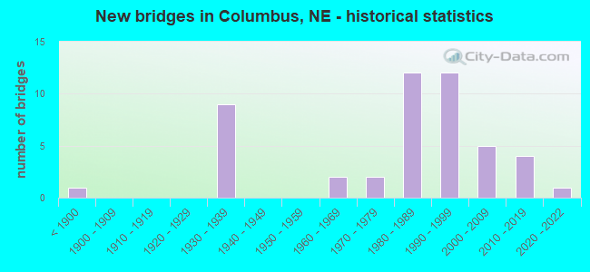
- New bridges - historical statistics
- 1Before 1900
- 91930-1939
- 21960-1969
- 21970-1979
- 121980-1989
- 121990-1999
- 52000-2009
- 42010-2019
- 12020-2022
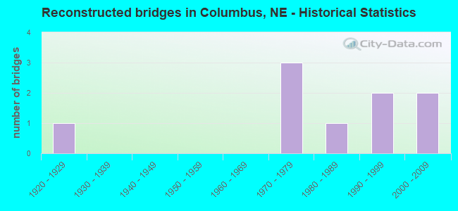
- Reconstructed bridges - Historical Statistics
- 11920-1929
- 01930-1939
- 01940-1949
- 01950-1959
- 01960-1969
- 31970-1979
- 11980-1989
- 21990-1999
- 22000-2009
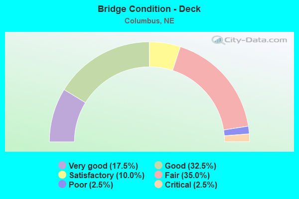
- Bridge Condition - Deck
- 17.5%Very good
- 32.5%Good
- 10.0%Satisfactory
- 35.0%Fair
- 2.5%Poor
- 2.5%Critical
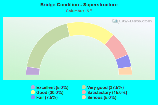
- Bridge Condition - Superstructure
- 5.0%Excellent
- 37.5%Very good
- 30.0%Good
- 15.0%Satisfactory
- 7.5%Fair
- 5.0%Serious
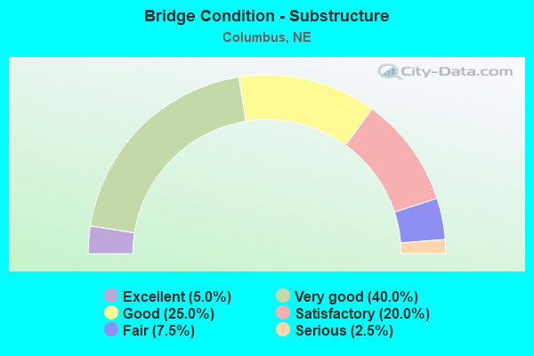
- Bridge Condition - Substructure
- 5.0%Excellent
- 40.0%Very good
- 25.0%Good
- 20.0%Satisfactory
- 7.5%Fair
- 2.5%Serious
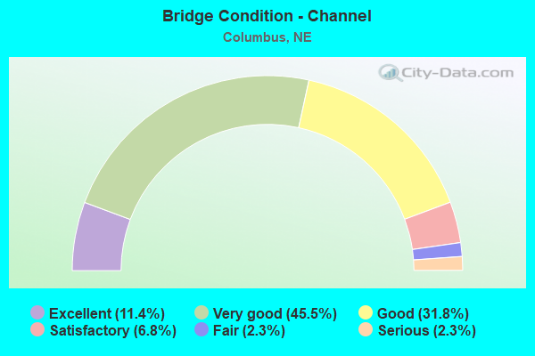
- Bridge Condition - Channel
- 11.4%Excellent
- 45.5%Very good
- 31.8%Good
- 6.8%Satisfactory
- 2.3%Fair
- 2.3%Serious
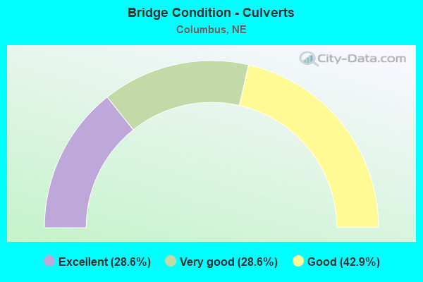
- Bridge Condition - Culverts
- 28.6%Excellent
- 28.6%Very good
- 42.9%Good
Find on map >> Show street view
Structure Number: S081 11598, Location: 4N COLUMBUS (Lat: 41.468800, Lng: -97.432600), Route carried "on" structure: US 81, Year Built: 1995, Status: Open, Structure Length: 1.58m (5.18ft), Average Daily Traffic: 10,560 (year 2018), Truck Traffic: 14%, Average Future Daily Traffic: 15,312 (year 2038), Design Load: HS 20, Features Intersected: LOST CREEK
Minimum Vertical Clearance: 30+ m (98+ ft), Kilometerpoint: 18.665, Lanes on structure: 4, Base Highway Network: Yes, Owner: State Highway Agency, Approaching Roadway Width: 21.3m (69.9ft), Material/Design: Concrete, Design/Construction: Culvert, Number Of Spans In Main Unit: 4, Length of Maximum Span: 3.0m (9.8ft)
Condition: Channel: Very good, Culverts: Good, Operating Rating: 43.0 metric tons, Method Used To Determine Operating Rating: Field evaluation and documented engineering judgment, Inventory Rating: 33.0 metric tons, Method Used To Determine Inventory Rating: Field evaluation and documented engineering judgment, Structural Evaluation: Better than present minimum criteria, Waterway Adequacy: Equal to present desirable criteria, Approach Roadway Alignment: Equal to present desirable criteria, Designated Inspection Frequency: Every 48 months, Inspection Date: June 2021
Find on map >> Show street view
Structure Number: U054504505, Location: 63RD AVE .5N US81 (Lat: 41.460600, Lng: -97.406900), Route carried "on" structure: City street 45, Year Built: 2010, Status: Open, Structure Length: 2.50m (8.20ft), Average Daily Traffic: 150 (year 2010), Truck Traffic: 5%, Average Future Daily Traffic: 225 (year 2033), Features Intersected: LOST CREEK, Facility Carried by Structure: 63RD AVE
Minimum Vertical Clearance: 30+ m (98+ ft), Kilometerpoint: 0.000, Lanes on structure: 2, Owner: City or Municipal Highway Agency, Approaching Roadway Width: 12.2m (40.0ft), Material/Design: Concrete continuous, Design/Construction: Slab, Number Of Spans In Main Unit: 3, Length of Maximum Span: 9.8m (32.2ft), Curb-To-Curb Width: 12.2m (40.0ft), Out-to-Out Width: 12.9m (42.3ft)
Condition: Deck: Good, Superstructure: Good, Substructure: Very good, Channel: Excellent, Operating Rating: 62.0 metric tons, Method Used To Determine Operating Rating: Load Factor (LF), Inventory Rating: 37.0 metric tons, Method Used To Determine Inventory Rating: Load Factor (LF), Structural Evaluation: Better than present minimum criteria, Deck Geometry: Superior to present desirable criteria, Waterway Adequacy: Superior to present desirable criteria, Approach Roadway Alignment: Better than present minimum criteria, Designated Inspection Frequency: Every 24 months, Inspection Date: June 2020, Deck Structure Type: Concrete Cast-file-Place, Wearing Surface/Protective System: Wearing Surface: Monolithic Concrete, Deck Protection: Epoxy Coated Reinforcing
Find on map >> Show street view
Structure Number: U054504615, Location: COTTONWOOD DRIVE @50TH AV (Lat: 41.424300, Lng: -97.390200), Route carried "on" structure: City street 46, Year Built: 1984, Status: Open, Structure Length: 1.83m (6.00ft), Average Daily Traffic: 250 (year 2003), Truck Traffic: 10%, Average Future Daily Traffic: 362 (year 2033), Features Intersected: LAKE ACCESS, Facility Carried by Structure: COTTONWOOD DRIVE
Minimum Vertical Clearance: 30+ m (98+ ft), Kilometerpoint: 0.000, Lanes on structure: 2, Owner: City or Municipal Highway Agency, Approaching Roadway Width: 8.5m (27.9ft), Material/Design: Prestressed concrete, Design/Construction: Tee Beam, Number Of Spans In Main Unit: 1, Length of Maximum Span: 17.7m (58.1ft), Curb-To-Curb Width: 8.5m (27.9ft), Out-to-Out Width: 8.5m (27.9ft)
Condition: Deck: Very good, Superstructure: Very good, Substructure: Very good, Channel: Satisfactory, Operating Rating: 44.0 metric tons, Method Used To Determine Operating Rating: Load Factor (LF), Inventory Rating: 13.0 metric tons, Method Used To Determine Inventory Rating: Load Factor (LF), Structural Evaluation: Meets minimum limits, Deck Geometry: Equal to present minimum criteria, Waterway Adequacy: Equal to present desirable criteria, Approach Roadway Alignment: Better than present minimum criteria, Designated Inspection Frequency: Every 24 months, Inspection Date: June 2020, Deck Structure Type: Concrete Cast-file-Place, Wearing Surface/Protective System: Wearing Surface: Monolithic Concrete
Find on map >> Show street view
Structure Number: U05450485, Location: 12 AVE IN COLUMBUS (Lat: 41.429000, Lng: -97.343100), Route carried "on" structure: City street , Year Built: 2020, Status: Open, Structure Length: 27.22m (89.30ft), Average Daily Traffic: 250 (year 2003), Average Future Daily Traffic: 362 (year 2033), Design Load: HL 93, Features Intersected: UPRR, Facility Carried by Structure: 12TH AVE
Minimum Vertical Clearance: 30+ m (98+ ft), Kilometerpoint: 0.000, Lanes on structure: 2, Owner: City or Municipal Highway Agency, Approaching Roadway Width: 9.8m (32.2ft), Material/Design: Steel, Design/Construction: Stringer/Multi-beam, Number Of Spans In Main Unit: 7, Length of Maximum Span: 42.7m (140.1ft), Curb or Sidewalk Widths: Left: 3.4m (11.2ft), Right: 0.0m, Curb-To-Curb Width: 9.8m (32.2ft), Out-to-Out Width: 10.2m (33.5ft)
Condition: Deck: Very good, Superstructure: Excellent, Substructure: Excellent, Operating Rating: 44.0 metric tons, Method Used To Determine Operating Rating: Load and Resistance Factor (LRFR), Inventory Rating: 34.0 metric tons, Method Used To Determine Inventory Rating: Load and Resistance Factor (LRFR), Structural Evaluation: Superior to present desirable criteria, Deck Geometry: Better than present minimum criteria, Underclear: High priority of corrective action, Approach Roadway Alignment: Superior to present desirable criteria, Designated Inspection Frequency: Every 24 months, Inspection Date: Febuary 2021, Deck Structure Type: Concrete Cast-file-Place, Wearing Surface/Protective System: Wearing Surface: Monolithic Concrete, Deck Protection: Epoxy Coated Reinforcing
Find on map >> Show street view
Structure Number: U054515315P, Location: CAMINO REAL @ 22ND ST (Lat: 41.436700, Lng: -97.326700), Route carried "on" structure: City street P153, Year Built: 1980, Year Reconstructed: 2013, Status: Posted for load, Structure Length: 2.44m (8.01ft), Average Daily Traffic: 100 (year 2003), Truck Traffic: 10%, Average Future Daily Traffic: 145 (year 2033), Features Intersected: CRISTOPHERS COVE LAKE, Facility Carried by Structure: CAMINO REAL
Minimum Vertical Clearance: 30+ m (98+ ft), Kilometerpoint: 0.000, Lanes on structure: 1, Owner: City or Municipal Highway Agency, Approaching Roadway Width: 9.1m (29.9ft), Material/Design: Steel, Design/Construction: Truss - Thru, Number Of Spans In Main Unit: 1, Length of Maximum Span: 24.1m (79.1ft), Curb-To-Curb Width: 4.4m (14.4ft), Out-to-Out Width: 4.5m (14.8ft)
Condition: Deck: Good, Superstructure: Fair, Substructure: Satisfactory, Channel: Very good, Operating Rating: 24.0 metric tons, Method Used To Determine Operating Rating: Load Factor (LF), Inventory Rating: 15.0 metric tons, Method Used To Determine Inventory Rating: Load Factor (LF), Structural Evaluation: Meets minimum limits, Deck Geometry: Equal to present minimum criteria, Waterway Adequacy: Superior to present desirable criteria, Approach Roadway Alignment: Equal to present minimum criteria, Bridge Posting: Required (Relationship of Operating Rating to Maximum Legal Load: 30.0 - 39.9% below), Length Of Structure Improvement: 2.44m (8.01ft), Designated Inspection Frequency: Every 24 months, Critical Feature Inspection Frequency: Every 24 months, Inspection Date: September 2021, Critical Feature Inspection Date: September 2021, Deck Structure Type: Concrete Precast Panels, Wearing Surface/Protective System: Wearing Surface: Monolithic Concrete, Deck Protection: Epoxy Coated Reinforcing
Find on map >> Show street view
Structure Number: U0545K4705, Location: IN COLUMBUS (Lat: 41.421200, Lng: -97.372300), Route carried "on" structure: City street K47, Year Built: 1935, Status: Posted for load, Structure Length: 0.88m (2.89ft), Average Daily Traffic: 200 (year 2003), Truck Traffic: 10%, Average Future Daily Traffic: 290 (year 2033), Features Intersected: STREAM, Facility Carried by Structure: PARK ROAD
Minimum Vertical Clearance: 30+ m (98+ ft), Kilometerpoint: 0.000, Lanes on structure: 1, Owner: City or Municipal Highway Agency, Approaching Roadway Width: 5.5m (18.0ft), Material/Design: Wood or Timber, Design/Construction: Stringer/Multi-beam, Number Of Spans In Main Unit: 2, Length of Maximum Span: 4.3m (14.1ft), Curb-To-Curb Width: 4.8m (15.7ft), Out-to-Out Width: 4.8m (15.7ft)
Condition: Deck: Fair, Superstructure: Fair, Substructure: Fair, Channel: Satisfactory, Operating Rating: 13.0 metric tons, Method Used To Determine Operating Rating: Allowable Stress (AS), Inventory Rating: 9.0 metric tons, Method Used To Determine Inventory Rating: Allowable Stress (AS), Structural Evaluation: High priority of corrective action, Deck Geometry: High priority of corrective action, Waterway Adequacy: Equal to present minimum criteria, Approach Roadway Alignment: Somewhat better than minimum adequacy, Bridge Posting: Required (Relationship of Operating Rating to Maximum Legal Load: > 39.9% below), Length Of Structure Improvement: 0.88m (2.89ft), Designated Inspection Frequency: Every 24 months, Inspection Date: June 2020, Deck Structure Type: Wood or Timber, Wearing Surface/Protective System: Wearing Surface: Wood or Timber
Find on map >> Show street view
Structure Number: S030 37787, Location: IN COLUMBUS (Lat: 41.418600, Lng: -97.368100), Route carried "under" structure: City street P46, Year Built: 1931, Structure Length: 0. m, Average Daily Traffic: 100 (year 1997), Truck Traffic: 10%, Features Intersected: PARK SUBWAY, Facility Carried by Structure: US30/US81
Minimum Vertical Clearance: 2.81m (9.22ft), Kilometerpoint: 0.000, Lanes on structure: 2, Lanes under structure: 2, Material/Design: Concrete, Design/Construction: Tee Beam, Length of Maximum Span: 7.3m (24.0ft)