Bridge Statistics for College Station, Texas (TX)
Condition, Traffic, Stress, Structural Evaluation, Project Costs
- National Bridge Inventory (NBI) Statistics
- 137Number of bridges
- 1,614ft / 492mTotal length
- $848,000Total costs
- 1,785,298Total average daily traffic
- 174,818Total average daily truck traffic
- National Bridge Inventory (NBI) Registered Bridges for College Station
- No street view available for this location
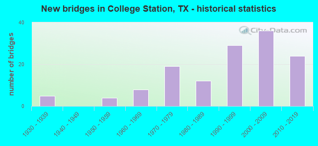
- New bridges - historical statistics
- 51930-1939
- 41950-1959
- 81960-1969
- 191970-1979
- 121980-1989
- 291990-1999
- 362000-2009
- 242010-2019
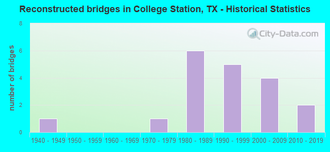
- Reconstructed bridges - Historical Statistics
- 11940-1949
- 01950-1959
- 01960-1969
- 11970-1979
- 61980-1989
- 51990-1999
- 42000-2009
- 22010-2019

- Bridge Condition - Deck
- 16.1%Very good
- 74.2%Good
- 4.8%Satisfactory
- 4.8%Fair
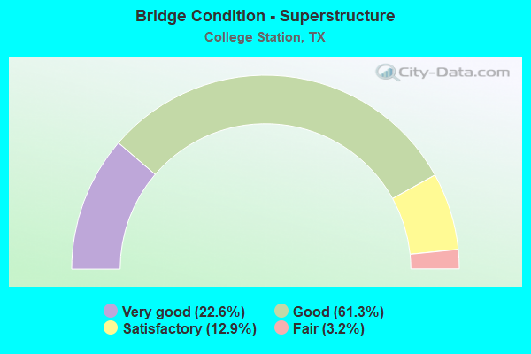
- Bridge Condition - Superstructure
- 22.6%Very good
- 61.3%Good
- 12.9%Satisfactory
- 3.2%Fair
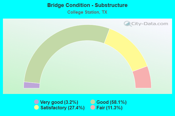
- Bridge Condition - Substructure
- 3.2%Very good
- 58.1%Good
- 27.4%Satisfactory
- 11.3%Fair
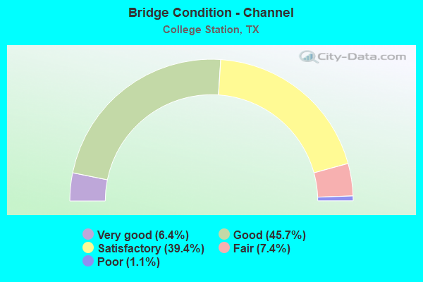
- Bridge Condition - Channel
- 6.4%Very good
- 45.7%Good
- 39.4%Satisfactory
- 7.4%Fair
- 1.1%Poor
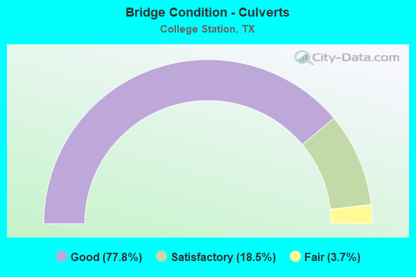
- Bridge Condition - Culverts
- 77.8%Good
- 18.5%Satisfactory
- 3.7%Fair
Find on map >> Show street view
Structure Number: 170210004912095, Location: 0.3 MI NW OF FM 60 (Lat: 30.644194, Lng: -96.313403), Route carried "on" structure: State highway 6, Year Built: 1971, Status: Open, Structure Length: 5.64m (18.50ft), Average Daily Traffic: 28,862 (year 2019), Truck Traffic: 14%, Average Future Daily Traffic: 39,190 (year 2033), Design Load: HS 20, Features Intersected: BURTON CREEK
Minimum Vertical Clearance: 30+ m (98+ ft), Kilometerpoint: 14.040, Lanes on structure: 2, Base Highway Network: Yes (Inventory Route: SH06SB00, Subroute: 1), Owner: State Highway Agency, Approaching Roadway Width: 12.2m (40.0ft), Skew: 4 degrees, Material/Design: Prestressed concrete, Design/Construction: Stringer/Multi-beam, Number Of Spans In Main Unit: 1, Number Of Approach Spans: 2, Length of Maximum Span: 22.9m (75.1ft), Curb-To-Curb Width: 12.8m (42.0ft), Out-to-Out Width: 13.5m (44.3ft)
Condition: Deck: Good, Superstructure: Good, Substructure: Good, Channel: Good, Operating Rating: 54.4 metric tons, Method Used To Determine Operating Rating: Assigned rating based on Load Factor Design (LFD) reported in metric tons, Inventory Rating: 32.7 metric tons, Method Used To Determine Inventory Rating: Assigned rating based on Load Factor Design (LFD) reported in metric tons, Structural Evaluation: Better than present minimum criteria, Deck Geometry: Equal to present desirable criteria, Waterway Adequacy: Equal to present desirable criteria, Approach Roadway Alignment: Equal to present desirable criteria, Designated Inspection Frequency: Every 24 months, Inspection Date: January 2021, Deck Structure Type: Concrete Cast-file-Place, Wearing Surface/Protective System: Wearing Surface: Bituminous
Find on map >> Show street view
Structure Number: 170210004912096, Location: 0.3 MI NW OF FM 60 (Lat: 30.644147, Lng: -96.312950), Route carried "on" structure: State highway 6, Year Built: 1971, Status: Open, Structure Length: 5.64m (18.50ft), Average Daily Traffic: 27,317 (year 2019), Truck Traffic: 14%, Average Future Daily Traffic: 39,190 (year 2033), Design Load: H 20, Features Intersected: BURTON CREEK
Minimum Vertical Clearance: 30+ m (98+ ft), Kilometerpoint: 14.069, Lanes on structure: 2, Base Highway Network: Yes (Inventory Route: SH06WFR0, Subroute: 1), Owner: State Highway Agency, Approaching Roadway Width: 12.2m (40.0ft), Skew: 4 degrees, Material/Design: Prestressed concrete, Design/Construction: Stringer/Multi-beam, Number Of Spans In Main Unit: 1, Number Of Approach Spans: 2, Length of Maximum Span: 22.9m (75.1ft), Curb-To-Curb Width: 13.4m (44.0ft), Out-to-Out Width: 14.1m (46.3ft)
Condition: Deck: Good, Superstructure: Very good, Substructure: Satisfactory, Channel: Satisfactory, Operating Rating: 65.3 metric tons, Method Used To Determine Operating Rating: Load Factor (LF), Inventory Rating: 28.1 metric tons, Method Used To Determine Inventory Rating: Load Factor (LF), Structural Evaluation: Equal to present minimum criteria, Deck Geometry: Superior to present desirable criteria, Waterway Adequacy: Equal to present desirable criteria, Approach Roadway Alignment: Equal to present desirable criteria, Designated Inspection Frequency: Every 24 months, Inspection Date: January 2021, Deck Structure Type: Concrete Cast-file-Place, Wearing Surface/Protective System: Wearing Surface: Bituminous
Find on map >> Show street view
Structure Number: 170210004912097, Location: 0.3 MI NW OF FM 60 (Lat: 30.644269, Lng: -96.313847), Route carried "on" structure: ServiceState highway 6, Year Built: 1971, Status: Open, Structure Length: 5.64m (18.50ft), Average Daily Traffic: 4,900 (year 2013), Truck Traffic: 10%, Average Future Daily Traffic: 6,860 (year 2033), Design Load: H 20, Features Intersected: BURTON CREEK
Minimum Vertical Clearance: 30+ m (98+ ft), Kilometerpoint: 14.009, Lanes on structure: 2, Base Highway Network: Yes (Inventory Route: SH06WFR0, Subroute: 1), Owner: State Highway Agency, Approaching Roadway Width: 8.5m (27.9ft), Skew: 4 degrees, Material/Design: Prestressed concrete, Design/Construction: Stringer/Multi-beam, Number Of Spans In Main Unit: 1, Number Of Approach Spans: 2, Length of Maximum Span: 22.9m (75.1ft), Curb-To-Curb Width: 10.4m (34.1ft), Out-to-Out Width: 11.1m (36.4ft)
Condition: Deck: Good, Superstructure: Good, Substructure: Satisfactory, Channel: Satisfactory, Operating Rating: 65.3 metric tons, Method Used To Determine Operating Rating: Load Factor (LF), Inventory Rating: 35.4 metric tons, Method Used To Determine Inventory Rating: Load Factor (LF), Structural Evaluation: Equal to present minimum criteria, Deck Geometry: Somewhat better than minimum adequacy, Waterway Adequacy: Equal to present desirable criteria, Approach Roadway Alignment: Equal to present desirable criteria, Designated Inspection Frequency: Every 24 months, Inspection Date: January 2021, Deck Structure Type: Concrete Cast-file-Place, Wearing Surface/Protective System: Wearing Surface: Bituminous
Find on map >> Show street view
Structure Number: 170210004912098, Location: 0.3 MI NW OF FM 60 (Lat: 30.644083, Lng: -96.312469), Route carried "on" structure: ServiceState highway 6, Year Built: 1971, Status: Open, Structure Length: 5.64m (18.50ft), Average Daily Traffic: 2,610 (year 2013), Truck Traffic: 9%, Average Future Daily Traffic: 3,660 (year 2033), Design Load: H 20, Features Intersected: BURTON CREEK
Minimum Vertical Clearance: 30+ m (98+ ft), Kilometerpoint: 14.104, Lanes on structure: 2, Base Highway Network: Yes (Inventory Route: SH06EFR0, Subroute: 1), Owner: State Highway Agency, Approaching Roadway Width: 8.5m (27.9ft), Skew: 4 degrees, Material/Design: Prestressed concrete, Design/Construction: Stringer/Multi-beam, Number Of Spans In Main Unit: 1, Number Of Approach Spans: 2, Length of Maximum Span: 22.9m (75.1ft), Curb-To-Curb Width: 10.4m (34.1ft), Out-to-Out Width: 11.1m (36.4ft)
Condition: Deck: Good, Superstructure: Good, Substructure: Fair, Channel: Fair, Operating Rating: 65.3 metric tons, Method Used To Determine Operating Rating: Load Factor (LF), Inventory Rating: 35.4 metric tons, Method Used To Determine Inventory Rating: Load Factor (LF), Structural Evaluation: Somewhat better than minimum adequacy, Deck Geometry: Somewhat better than minimum adequacy, Waterway Adequacy: Equal to present desirable criteria, Approach Roadway Alignment: Equal to present desirable criteria, Designated Inspection Frequency: Every 24 months, Inspection Date: January 2021, Deck Structure Type: Concrete Cast-file-Place, Wearing Surface/Protective System: Wearing Surface: Bituminous
Find on map >> Show street view
Structure Number: 170210004912099, Location: 0.81 MI NW OF SH 30 (Lat: 30.640564, Lng: -96.310097), Route carried "on" structure: State highway 60, Year Built: 1971, Year Reconstructed: 2001, Status: Open, Structure Length: 8.84m (29.00ft), Average Daily Traffic: 34,380 (year 2013), Truck Traffic: 13%, Average Future Daily Traffic: 48,130 (year 2033), Design Load: H 20, Features Intersected: SH 6
Minimum Vertical Clearance: 4.93m (16.17ft), Kilometerpoint: 14.381, Lanes on structure: 4, Lanes under structure: 6, Base Highway Network: Yes (Inventory Route: FM600000, Subroute: 1), Owner: State Highway Agency, Approaching Roadway Width: 24.4m (80.1ft), Skew: 20 degrees, Material/Design: Prestressed concrete, Design/Construction: Stringer/Multi-beam, Number Of Spans In Main Unit: 2, Number Of Approach Spans: 2, Length of Maximum Span: 29.0m (95.1ft), Curb or Sidewalk Widths: Left: 1.8m (5.9ft), Right: 1.8m (5.9ft), Curb-To-Curb Width: 16.9m (55.4ft), Out-to-Out Width: 29.1m (95.5ft)
Condition: Deck: Very good, Superstructure: Good, Substructure: Good, Operating Rating: 65.3 metric tons, Method Used To Determine Operating Rating: Load Factor (LF), Inventory Rating: 30.8 metric tons, Method Used To Determine Inventory Rating: Load Factor (LF), Structural Evaluation: Better than present minimum criteria, Deck Geometry: Somewhat better than minimum adequacy, Underclear: Somewhat better than minimum adequacy, Approach Roadway Alignment: Equal to present desirable criteria, Designated Inspection Frequency: Every 24 months, Inspection Date: January 2021, Deck Structure Type: Concrete Cast-file-Place, Wearing Surface/Protective System: Wearing Surface: Bituminous
Find on map >> Show street view
Structure Number: 1702100049121, Location: 0.05 MI N OF SH 30 (Lat: 30.631050, Lng: -96.301756), Route carried "on" structure: ServiceState highway 6, Year Built: 1971, Status: Open, Structure Length: 0.79m (2.59ft), Average Daily Traffic: 4,420 (year 2013), Truck Traffic: 9%, Average Future Daily Traffic: 6,190 (year 2033), Design Load: HS 20, Features Intersected: DRAIN
Minimum Vertical Clearance: 30+ m (98+ ft), Kilometerpoint: 15.902, Lanes on structure: 2, Base Highway Network: Yes (Inventory Route: SH06EFR0, Subroute: 1), Owner: State Highway Agency, Approaching Roadway Width: 8.5m (27.9ft), Skew: 3 degrees, Material/Design: Concrete, Design/Construction: Culvert, Number Of Spans In Main Unit: 3, Length of Maximum Span: 2.1m (6.9ft), Curb-To-Curb Width: 9.6m (31.5ft), Out-to-Out Width: 14.7m (48.2ft)
Condition: Channel: Good, Culverts: Good, Operating Rating: 39.9 metric tons, Method Used To Determine Operating Rating: Load Factor (LF), Inventory Rating: 23.6 metric tons, Method Used To Determine Inventory Rating: Load Factor (LF), Structural Evaluation: Equal to present minimum criteria, Deck Geometry: Meets minimum limits, Waterway Adequacy: Equal to present desirable criteria, Approach Roadway Alignment: Equal to present desirable criteria, Length Of Structure Improvement: 0.61m (2.00ft), Designated Inspection Frequency: Every 24 months, Inspection Date: May 2021, Bridge Improvement Cost: $53,000, Roadway Improvement Cost: $5,000, Total Project Cost: $80,000, Deck Structure Type: Concrete Cast-file-Place, Wearing Surface/Protective System: Wearing Surface: Bituminous
Find on map >> Show street view
Structure Number: 170210004912101, Location: 0.87 MI SE OF FM 60 (Lat: 30.629850, Lng: -96.302186), Route carried "on" structure: State highway 6, Year Built: 1971, Status: Open, Structure Length: 5.33m (17.49ft), Average Daily Traffic: 30,650 (year 2013), Truck Traffic: 14%, Average Future Daily Traffic: 42,920 (year 2033), Design Load: HS 20, Features Intersected: SH 30
Minimum Vertical Clearance: 30+ m (98+ ft), Kilometerpoint: 15.982, Lanes on structure: 2, Lanes under structure: 8, Base Highway Network: Yes (Inventory Route: SH06NB00, Subroute: 1), Owner: State Highway Agency, Approaching Roadway Width: 12.2m (40.0ft), Skew: 1 degrees, Material/Design: Prestressed concrete, Design/Construction: Stringer/Multi-beam, Number Of Spans In Main Unit: 1, Number Of Approach Spans: 2, Length of Maximum Span: 29.0m (95.1ft), Curb-To-Curb Width: 12.5m (41.0ft), Out-to-Out Width: 13.5m (44.3ft)
Condition: Deck: Good, Superstructure: Satisfactory, Substructure: Fair, Operating Rating: 54.4 metric tons, Method Used To Determine Operating Rating: Assigned rating based on Load Factor Design (LFD) reported in metric tons, Inventory Rating: 32.7 metric tons, Method Used To Determine Inventory Rating: Assigned rating based on Load Factor Design (LFD) reported in metric tons, Structural Evaluation: Somewhat better than minimum adequacy, Deck Geometry: Better than present minimum criteria, Underclear: Meets minimum limits, Approach Roadway Alignment: Equal to present desirable criteria, Designated Inspection Frequency: Every 24 months, Inspection Date: January 2021, Deck Structure Type: Concrete Cast-file-Place, Wearing Surface/Protective System: Wearing Surface: Bituminous
Find on map >> Show street view
Structure Number: 170210004912102, Location: 0.87 MI SE OF FM 60 (Lat: 30.629636, Lng: -96.302425), Route carried "on" structure: State highway 6, Year Built: 1971, Status: Open, Structure Length: 5.33m (17.49ft), Average Daily Traffic: 33,477 (year 2019), Truck Traffic: 14%, Average Future Daily Traffic: 42,920 (year 2033), Design Load: HS 20, Features Intersected: SH 30
Minimum Vertical Clearance: 30+ m (98+ ft), Kilometerpoint: 15.992, Lanes on structure: 2, Lanes under structure: 8, Base Highway Network: Yes (Inventory Route: SH06SB00, Subroute: 1), Owner: State Highway Agency, Approaching Roadway Width: 12.2m (40.0ft), Skew: 1 degrees, Material/Design: Prestressed concrete, Design/Construction: Stringer/Multi-beam, Number Of Spans In Main Unit: 1, Number Of Approach Spans: 2, Length of Maximum Span: 29.0m (95.1ft), Curb-To-Curb Width: 12.5m (41.0ft), Out-to-Out Width: 13.5m (44.3ft)
Condition: Deck: Good, Superstructure: Satisfactory, Substructure: Fair, Operating Rating: 54.4 metric tons, Method Used To Determine Operating Rating: Assigned rating based on Load Factor Design (LFD) reported in metric tons, Inventory Rating: 32.7 metric tons, Method Used To Determine Inventory Rating: Assigned rating based on Load Factor Design (LFD) reported in metric tons, Structural Evaluation: Somewhat better than minimum adequacy, Deck Geometry: Better than present minimum criteria, Underclear: Meets minimum limits, Approach Roadway Alignment: Equal to present desirable criteria, Designated Inspection Frequency: Every 24 months, Inspection Date: January 2021, Deck Structure Type: Concrete Cast-file-Place, Wearing Surface/Protective System: Wearing Surface: Bituminous
Find on map >> Show street view
Structure Number: 170210004912103, Location: 0.58 MI SE OF SH 30 (Lat: 30.622383, Lng: -96.297497), Route carried "on" structure: State highway 6, Year Built: 1971, Status: Open, Structure Length: 1.49m (4.89ft), Average Daily Traffic: 57,636 (year 2020), Truck Traffic: 14%, Average Future Daily Traffic: 67,180 (year 2033), Design Load: HS 20, Features Intersected: DRAW
Minimum Vertical Clearance: 30+ m (98+ ft), Kilometerpoint: 16.938, Lanes on structure: 10, Base Highway Network: Yes (Inventory Route: SH060000, Subroute: 1), Owner: State Highway Agency, Approaching Roadway Width: 49.4m (162.1ft), Skew: 23 degrees, Material/Design: Concrete, Design/Construction: Culvert, Number Of Spans In Main Unit: 4, Length of Maximum Span: 3.0m (9.8ft)
Condition: Channel: Satisfactory, Culverts: Satisfactory, Operating Rating: 39.9 metric tons, Method Used To Determine Operating Rating: Load Factor (LF), Inventory Rating: 23.6 metric tons, Method Used To Determine Inventory Rating: Load Factor (LF), Structural Evaluation: Somewhat better than minimum adequacy, Waterway Adequacy: Equal to present desirable criteria, Approach Roadway Alignment: Equal to present desirable criteria, Designated Inspection Frequency: Every 24 months, Inspection Date: May 2021
Find on map >> Show street view
Structure Number: 170210004912104, Location: 1.82 MI SE OF SH 30 (Lat: 30.606000, Lng: -96.290772), Route carried "on" structure: State highway 6, Year Built: 1971, Year Reconstructed: 1989, Status: Open, Structure Length: 3.20m (10.50ft), Average Daily Traffic: 58,504 (year 2020), Truck Traffic: 10%, Average Future Daily Traffic: 77,750 (year 2033), Design Load: HS 20, Features Intersected: BEE CREEK
Minimum Vertical Clearance: 30+ m (98+ ft), Kilometerpoint: 18.926, Lanes on structure: 9, Base Highway Network: Yes (Inventory Route: SH060000, Subroute: 1), Owner: State Highway Agency, Approaching Roadway Width: 49.7m (163.1ft), Skew: 20 degrees, Material/Design: Concrete, Design/Construction: Culvert, Number Of Spans In Main Unit: 11, Length of Maximum Span: 2.7m (8.9ft)
Condition: Channel: Fair, Culverts: Fair, Operating Rating: 39.9 metric tons, Method Used To Determine Operating Rating: Load Factor (LF), Inventory Rating: 23.6 metric tons, Method Used To Determine Inventory Rating: Load Factor (LF), Structural Evaluation: Somewhat better than minimum adequacy, Waterway Adequacy: Equal to present desirable criteria, Approach Roadway Alignment: Equal to present desirable criteria, Designated Inspection Frequency: Every 24 months, Inspection Date: January 2021
Find on map >> Show street view
Structure Number: 170210004912105, Location: 1.98 MI SE OF SH 30 (Lat: 30.603000, Lng: -96.290936), Route carried "on" structure: ServiceState highway 6, Year Built: 1971, Year Reconstructed: 1989, Status: Open, Structure Length: 1.49m (4.89ft), Average Daily Traffic: 15,625 (year 2014), Truck Traffic: 9%, Average Future Daily Traffic: 16,500 (year 2031), Design Load: HS 20, Features Intersected: DRAW
Minimum Vertical Clearance: 30+ m (98+ ft), Kilometerpoint: 19.182, Lanes on structure: 4, Base Highway Network: Yes (Inventory Route: FM281800, Subroute: 1), Owner: State Highway Agency, Approaching Roadway Width: 24.4m (80.1ft), Skew: 29 degrees, Material/Design: Concrete, Design/Construction: Culvert, Number Of Spans In Main Unit: 4, Length of Maximum Span: 3.0m (9.8ft)
Condition: Channel: Good, Culverts: Satisfactory, Operating Rating: 39.9 metric tons, Method Used To Determine Operating Rating: Load Factor (LF), Inventory Rating: 23.6 metric tons, Method Used To Determine Inventory Rating: Load Factor (LF), Structural Evaluation: Somewhat better than minimum adequacy, Waterway Adequacy: Equal to present desirable criteria, Approach Roadway Alignment: Equal to present desirable criteria, Designated Inspection Frequency: Every 24 months, Inspection Date: January 2021
Find on map >> Show street view
Structure Number: 170210004912106, Location: 2.71 MI SE OF SH 30 (Lat: 30.592964, Lng: -96.290594), Route carried "on" structure: State highway 6, Year Built: 1971, Status: Open, Structure Length: 9.60m (31.50ft), Average Daily Traffic: 17,650 (year 2013), Truck Traffic: 14%, Average Future Daily Traffic: 24,710 (year 2033), Design Load: HS 20, Features Intersected: BS 6 NB
Minimum Vertical Clearance: 30+ m (98+ ft), Kilometerpoint: 20.357, Lanes on structure: 2, Lanes under structure: 1, Base Highway Network: Yes (Inventory Route: SH06SB00, Subroute: 1), Owner: State Highway Agency, Approaching Roadway Width: 12.2m (40.0ft), Skew: 9 degrees, Material/Design: Steel continuous, Design/Construction: Stringer/Multi-beam, Number Of Spans In Main Unit: 1, Number Of Approach Spans: 2, Length of Maximum Span: 47.2m (154.9ft), Curb-To-Curb Width: 12.8m (42.0ft), Out-to-Out Width: 13.6m (44.6ft)
Condition: Deck: Satisfactory, Superstructure: Good, Substructure: Good, Operating Rating: 44.4 metric tons, Method Used To Determine Operating Rating: Assigned ratings based on Allowable Stress Design (ASD) reported in metric tons, Inventory Rating: 32.7 metric tons, Method Used To Determine Inventory Rating: Assigned ratings based on Allowable Stress Design (ASD) reported in metric tons, Structural Evaluation: Better than present minimum criteria, Deck Geometry: Equal to present desirable criteria, Underclear: Superior to present desirable criteria, Approach Roadway Alignment: Equal to present desirable criteria, Designated Inspection Frequency: Every 24 months, Inspection Date: January 2021, Deck Structure Type: Concrete Cast-file-Place
Find on map >> Show street view
Structure Number: 170210004912131, Location: 1.98 MI SE OF SH 30 (Lat: 30.602775, Lng: -96.289928), Route carried "on" structure: State highway 6, Year Built: 1990, Status: Open, Structure Length: 11.58m (37.99ft), Average Daily Traffic: 25,083 (year 2019), Truck Traffic: 10%, Average Future Daily Traffic: 38,870 (year 2033), Design Load: HS 20, Features Intersected: FM 2818
Minimum Vertical Clearance: 30+ m (98+ ft), Kilometerpoint: 19.159, Lanes on structure: 2, Lanes under structure: 8, Base Highway Network: Yes (Inventory Route: SH06NB00, Subroute: 1), Owner: State Highway Agency, Approaching Roadway Width: 12.2m (40.0ft), Material/Design: Prestressed concrete, Design/Construction: Stringer/Multi-beam, Number Of Spans In Main Unit: 3, Number Of Approach Spans: 2, Length of Maximum Span: 29.0m (95.1ft), Curb-To-Curb Width: 11.9m (39.0ft), Out-to-Out Width: 12.8m (42.0ft)
Condition: Deck: Good, Superstructure: Good, Substructure: Satisfactory, Operating Rating: 54.4 metric tons, Method Used To Determine Operating Rating: Assigned rating based on Load Factor Design (LFD) reported in metric tons, Inventory Rating: 32.7 metric tons, Method Used To Determine Inventory Rating: Assigned rating based on Load Factor Design (LFD) reported in metric tons, Structural Evaluation: Equal to present minimum criteria, Deck Geometry: Equal to present minimum criteria, Underclear: Somewhat better than minimum adequacy, Approach Roadway Alignment: Equal to present desirable criteria, Designated Inspection Frequency: Every 24 months, Inspection Date: January 2021, Deck Structure Type: Concrete Cast-file-Place, Wearing Surface/Protective System: Wearing Surface: Bituminous
Find on map >> Show street view
Structure Number: 170210004912132, Location: 1.98 MI SE OF SH 30 (Lat: 30.603683, Lng: -96.290344), Route carried "on" structure: State highway 6, Year Built: 1990, Status: Open, Structure Length: 9.75m (31.99ft), Average Daily Traffic: 37,180 (year 2019), Truck Traffic: 10%, Average Future Daily Traffic: 38,870 (year 2033), Design Load: HS 20, Features Intersected: FM 2818
Minimum Vertical Clearance: 30+ m (98+ ft), Kilometerpoint: 19.179, Lanes on structure: 2, Lanes under structure: 8, Base Highway Network: Yes (Inventory Route: SH06SB00, Subroute: 1), Owner: State Highway Agency, Approaching Roadway Width: 12.2m (40.0ft), Material/Design: Prestressed concrete, Design/Construction: Stringer/Multi-beam, Number Of Spans In Main Unit: 1, Number Of Approach Spans: 3, Length of Maximum Span: 35.1m (115.2ft), Curb-To-Curb Width: 11.8m (38.7ft), Out-to-Out Width: 12.8m (42.0ft)
Condition: Deck: Good, Superstructure: Good, Substructure: Good, Operating Rating: 54.4 metric tons, Method Used To Determine Operating Rating: Assigned rating based on Load Factor Design (LFD) reported in metric tons, Inventory Rating: 32.7 metric tons, Method Used To Determine Inventory Rating: Assigned rating based on Load Factor Design (LFD) reported in metric tons, Structural Evaluation: Better than present minimum criteria, Deck Geometry: Equal to present minimum criteria, Underclear: Somewhat better than minimum adequacy, Approach Roadway Alignment: Equal to present desirable criteria, Designated Inspection Frequency: Every 24 months, Inspection Date: January 2021, Deck Structure Type: Concrete Cast-file-Place, Wearing Surface/Protective System: Wearing Surface: Bituminous
Find on map >> Show street view
Structure Number: 170210004912133, Location: 3.58 MI SE OF SH 30 (Lat: 30.584894, Lng: -96.284950), Route carried "on" structure: City street , Year Built: 1990, Year Reconstructed: 2014, Status: Open, Structure Length: 7.92m (25.98ft), Average Daily Traffic: 21,360 (year 2015), Truck Traffic: 1%, Average Future Daily Traffic: 34,000 (year 2035), Design Load: HS 20, Features Intersected: SH 6, Facility Carried by Structure: ROCK PRAIRIE RD
Minimum Vertical Clearance: 5.05m (16.57ft), Kilometerpoint: 0.080, Lanes on structure: 5, Lanes under structure: 5, Owner: State Highway Agency, Approaching Roadway Width: 14.6m (47.9ft), Material/Design: Prestressed concrete, Design/Construction: Stringer/Multi-beam, Number Of Spans In Main Unit: 4, Length of Maximum Span: 21.3m (69.9ft), Curb or Sidewalk Widths: Left: 3.0m (9.8ft), Right: 3.0m (9.8ft), Curb-To-Curb Width: 23.5m (77.1ft), Out-to-Out Width: 44.2m (145.0ft)
Condition: Deck: Good, Superstructure: Good, Substructure: Good, Operating Rating: 54.4 metric tons, Method Used To Determine Operating Rating: Assigned rating based on Load Factor Design (LFD) reported in metric tons, Inventory Rating: 32.7 metric tons, Method Used To Determine Inventory Rating: Assigned rating based on Load Factor Design (LFD) reported in metric tons, Structural Evaluation: Better than present minimum criteria, Deck Geometry: Better than present minimum criteria, Underclear: High priority of corrective action, Approach Roadway Alignment: Equal to present desirable criteria, Designated Inspection Frequency: Every 24 months, Inspection Date: January 2021, Deck Structure Type: Concrete Cast-file-Place
Find on map >> Show street view
Structure Number: 17021000491214, Location: 0.85 MI SE OF SH 30 (Lat: 30.618522, Lng: -96.295667), Route carried "on" structure: City street , Year Built: 1994, Status: Open, Structure Length: 8.84m (29.00ft), Average Daily Traffic: 15,000 (year 2011), Truck Traffic: 1%, Average Future Daily Traffic: 10,350 (year 2031), Design Load: HS 20, Features Intersected: SH 6, Facility Carried by Structure: SOUTHWEST PKWY
Minimum Vertical Clearance: 4.98m (16.34ft), Kilometerpoint: 14.986, Lanes on structure: 5, Lanes under structure: 4, Owner: State Highway Agency, Approaching Roadway Width: 19.5m (64.0ft), Material/Design: Prestressed concrete, Design/Construction: Box Beam or Girders - Multiple, Number Of Spans In Main Unit: 2, Number Of Approach Spans: 2, Length of Maximum Span: 30.5m (100.1ft), Curb or Sidewalk Widths: Left: 1.9m (6.2ft), Right: 0.0m, Curb-To-Curb Width: 19.4m (63.6ft), Out-to-Out Width: 22.4m (73.5ft)
Condition: Deck: Very good, Superstructure: Good, Substructure: Satisfactory, Operating Rating: 54.4 metric tons, Method Used To Determine Operating Rating: Assigned rating based on Load Factor Design (LFD) reported in metric tons, Inventory Rating: 32.7 metric tons, Method Used To Determine Inventory Rating: Assigned rating based on Load Factor Design (LFD) reported in metric tons, Structural Evaluation: Equal to present minimum criteria, Deck Geometry: Meets minimum limits, Underclear: Somewhat better than minimum adequacy, Approach Roadway Alignment: Equal to present desirable criteria, Designated Inspection Frequency: Every 24 months, Inspection Date: January 2021, Deck Structure Type: Concrete Cast-file-Place, Wearing Surface/Protective System: Wearing Surface: Bituminous
Find on map >> Show street view
Structure Number: 170210004912167, Location: 2.71 MI SE OF SH 30 (Lat: 30.593303, Lng: -96.290958), Route carried "on" structure: Ramp State highway 6, Year Built: 2009, Status: Open, Structure Length: 32.31m (106.00ft), Average Daily Traffic: 11,000 (year 2014), Truck Traffic: 6%, Average Future Daily Traffic: 11,500 (year 2031), Design Load: HS 20, Features Intersected: SH 6 SB ONR / BS 6 NB
Minimum Vertical Clearance: 30+ m (98+ ft), Kilometerpoint: 20.357, Lanes on structure: 1, Lanes under structure: 2, Owner: State Highway Agency, Approaching Roadway Width: 7.3m (24.0ft), Material/Design: Prestressed concrete, Design/Construction: Stringer/Multi-beam, Number Of Spans In Main Unit: 9, Length of Maximum Span: 39.6m (129.9ft), Curb-To-Curb Width: 7.2m (23.6ft), Out-to-Out Width: 7.9m (25.9ft)
Condition: Deck: Very good, Superstructure: Very good, Substructure: Good, Operating Rating: 54.4 metric tons, Method Used To Determine Operating Rating: Assigned rating based on Load Factor Design (LFD) reported in metric tons, Inventory Rating: 32.7 metric tons, Method Used To Determine Inventory Rating: Assigned rating based on Load Factor Design (LFD) reported in metric tons, Structural Evaluation: Better than present minimum criteria, Deck Geometry: Equal to present minimum criteria, Underclear: Superior to present desirable criteria, Approach Roadway Alignment: Equal to present desirable criteria, Designated Inspection Frequency: Every 24 months, Inspection Date: January 2021, Deck Structure Type: Concrete Precast Panels
Find on map >> Show street view
Structure Number: 170210005001004, Location: 0.2 MI NW OF FM 2818 (Lat: 30.602681, Lng: -96.302950), Route carried "on" structure: State highway 6, Year Built: 1932, Year Reconstructed: 2007, Status: Open, Structure Length: 1.98m (6.50ft), Average Daily Traffic: 48,130 (year 2013), Truck Traffic: 14%, Average Future Daily Traffic: 67,390 (year 2033), Design Load: H 20, Features Intersected: BEE CREEK
Minimum Vertical Clearance: 30+ m (98+ ft), Kilometerpoint: 12.373, Lanes on structure: 6, Base Highway Network: Yes (Inventory Route: BS060000, Subroute: 1), Owner: State Highway Agency, Approaching Roadway Width: 25.0m (82.0ft), Skew: 20 degrees, Material/Design: Concrete, Design/Construction: Culvert, Number Of Spans In Main Unit: 6, Length of Maximum Span: 3.0m (9.8ft), Curb or Sidewalk Widths: Left: 1.8m (5.9ft), Right: 1.8m (5.9ft), Curb-To-Curb Width: 25.2m (82.7ft), Out-to-Out Width: 43.1m (141.4ft)
Condition: Channel: Good, Culverts: Satisfactory, Operating Rating: 39.9 metric tons, Method Used To Determine Operating Rating: Load Factor (LF), Inventory Rating: 23.6 metric tons, Method Used To Determine Inventory Rating: Load Factor (LF), Structural Evaluation: Somewhat better than minimum adequacy, Deck Geometry: Somewhat better than minimum adequacy, Waterway Adequacy: Superior to present desirable criteria, Approach Roadway Alignment: Equal to present desirable criteria, Designated Inspection Frequency: Every 24 months, Inspection Date: January 2021, Deck Structure Type: Concrete Cast-file-Place, Wearing Surface/Protective System: Wearing Surface: Bituminous
Find on map >> Show street view
Structure Number: 170210005001005, Location: 0.4 MI SE OF FM 2818 (Lat: 30.596531, Lng: -96.295708), Route carried "on" structure: State highway 6, Year Built: 1932, Year Reconstructed: 1986, Status: Open, Structure Length: 1.01m (3.31ft), Average Daily Traffic: 26,230 (year 2013), Truck Traffic: 14%, Average Future Daily Traffic: 36,730 (year 2033), Design Load: H 20, Features Intersected: BEE CREEK BRANCH
Minimum Vertical Clearance: 30+ m (98+ ft), Kilometerpoint: 13.353, Lanes on structure: 7, Base Highway Network: Yes (Inventory Route: BS060000, Subroute: 1), Owner: State Highway Agency, Approaching Roadway Width: 31.7m (104.0ft), Material/Design: Concrete, Design/Construction: Culvert, Number Of Spans In Main Unit: 3, Length of Maximum Span: 3.0m (9.8ft), Curb-To-Curb Width: 31.7m (104.0ft), Out-to-Out Width: 46.5m (152.6ft)
Condition: Channel: Satisfactory, Culverts: Satisfactory, Operating Rating: 39.9 metric tons, Method Used To Determine Operating Rating: Load Factor (LF), Inventory Rating: 23.6 metric tons, Method Used To Determine Inventory Rating: Load Factor (LF), Structural Evaluation: Somewhat better than minimum adequacy, Deck Geometry: Superior to present desirable criteria, Waterway Adequacy: Equal to present minimum criteria, Approach Roadway Alignment: Equal to present desirable criteria, Length Of Structure Improvement: 0.91m (2.99ft), Designated Inspection Frequency: Every 24 months, Inspection Date: January 2021, Bridge Improvement Cost: $98,000, Roadway Improvement Cost: $9,000, Total Project Cost: $148,000, Deck Structure Type: Concrete Cast-file-Place, Wearing Surface/Protective System: Wearing Surface: Bituminous
Find on map >> Show street view
Structure Number: 170210005001034, Location: 0.02 MI S OF SH 30 (Lat: 30.615050, Lng: -96.318439), Route carried "on" structure: State highway 6, Year Built: 1960, Year Reconstructed: 2006, Status: Open, Structure Length: 1.16m (3.81ft), Average Daily Traffic: 48,130 (year 2013), Truck Traffic: 14%, Average Future Daily Traffic: 67,390 (year 2033), Design Load: H 20, Features Intersected: WOLFPEN CREEK
Minimum Vertical Clearance: 30+ m (98+ ft), Kilometerpoint: 10.342, Lanes on structure: 7, Base Highway Network: Yes (Inventory Route: BS060000, Subroute: 1), Owner: State Highway Agency, Approaching Roadway Width: 25.6m (84.0ft), Skew: 33 degrees, Material/Design: Concrete, Design/Construction: Culvert, Number Of Spans In Main Unit: 3, Length of Maximum Span: 3.0m (9.8ft), Curb or Sidewalk Widths: Left: 1.8m (5.9ft), Right: 1.8m (5.9ft), Curb-To-Curb Width: 29.4m (96.5ft), Out-to-Out Width: 43.5m (142.7ft)
Condition: Channel: Satisfactory, Culverts: Satisfactory, Operating Rating: 39.9 metric tons, Method Used To Determine Operating Rating: Load Factor (LF), Inventory Rating: 23.6 metric tons, Method Used To Determine Inventory Rating: Load Factor (LF), Structural Evaluation: Somewhat better than minimum adequacy, Deck Geometry: Somewhat better than minimum adequacy, Waterway Adequacy: Equal to present minimum criteria, Approach Roadway Alignment: Equal to present desirable criteria, Designated Inspection Frequency: Every 24 months, Inspection Date: January 2021, Deck Structure Type: Concrete Cast-file-Place, Wearing Surface/Protective System: Wearing Surface: Bituminous
Find on map >> Show street view
Structure Number: 170210005002007, Location: 2.75 MI S OF FM 2818 (Lat: 30.572667, Lng: -96.273867), Route carried "on" structure: State highway 6, Year Built: 1932, Year Reconstructed: 1990, Status: Open, Structure Length: 0.98m (3.22ft), Average Daily Traffic: 37,905 (year 2019), Truck Traffic: 14%, Average Future Daily Traffic: 36,160 (year 2033), Features Intersected: LICK CREEK BRANCH
Minimum Vertical Clearance: 30+ m (98+ ft), Kilometerpoint: 16.766, Lanes on structure: 9, Owner: State Highway Agency, Approaching Roadway Width: 45.7m (149.9ft), Skew: 39 degrees, Material/Design: Concrete, Design/Construction: Culvert, Number Of Spans In Main Unit: 3, Length of Maximum Span: 3.0m (9.8ft)
Condition: Channel: Satisfactory, Culverts: Good, Operating Rating: 32.7 metric tons, Method Used To Determine Operating Rating: Field evaluation and documented engineering judgment, Inventory Rating: 24.5 metric tons, Method Used To Determine Inventory Rating: Field evaluation and documented engineering judgment, Structural Evaluation: Equal to present minimum criteria, Waterway Adequacy: Equal to present desirable criteria, Approach Roadway Alignment: Equal to present desirable criteria, Designated Inspection Frequency: Every 24 months, Inspection Date: January 2021
Find on map >> Show street view
Structure Number: 170210005002008, Location: 3.64 MI SE OF FM 2818 (Lat: 30.563842, Lng: -96.263253), Route carried "on" structure: State highway 6, Year Built: 1932, Year Reconstructed: 1990, Status: Open, Structure Length: 2.99m (9.81ft), Average Daily Traffic: 37,905 (year 2019), Truck Traffic: 14%, Average Future Daily Traffic: 36,160 (year 2033), Design Load: H 20, Features Intersected: SPRING CREEK
Minimum Vertical Clearance: 30+ m (98+ ft), Kilometerpoint: 18.157, Lanes on structure: 4, Base Highway Network: Yes (Inventory Route: SH060000, Subroute: 1), Owner: State Highway Agency, Approaching Roadway Width: 27.4m (89.9ft), Skew: 30 degrees, Material/Design: Concrete, Design/Construction: Tee Beam, Number Of Spans In Main Unit: 4, Length of Maximum Span: 7.3m (24.0ft), Curb-To-Curb Width: 27.2m (89.2ft), Out-to-Out Width: 28.7m (94.2ft)
Condition: Deck: Good, Superstructure: Good, Substructure: Satisfactory, Channel: Good, Operating Rating: 51.7 metric tons, Method Used To Determine Operating Rating: Load Factor (LF), Inventory Rating: 30.8 metric tons, Method Used To Determine Inventory Rating: Load Factor (LF), Structural Evaluation: Equal to present minimum criteria, Deck Geometry: Superior to present desirable criteria, Waterway Adequacy: Equal to present minimum criteria, Approach Roadway Alignment: Equal to present desirable criteria, Designated Inspection Frequency: Every 24 months, Inspection Date: January 2021, Deck Structure Type: Concrete Cast-file-Place, Wearing Surface/Protective System: Wearing Surface: Bituminous
Find on map >> Show street view
Structure Number: 170210005002123, Location: 3.64 MI SE OF FM 2818 (Lat: 30.564000, Lng: -96.263053), Route carried "on" structure: ServiceState highway 6, Year Built: 1990, Year Reconstructed: 2010, Status: Open, Structure Length: 3.96m (12.99ft), Average Daily Traffic: 13,714 (year 2019), Truck Traffic: 11%, Average Future Daily Traffic: 13,000 (year 2031), Design Load: HS 20, Features Intersected: SPRING CREEK
Minimum Vertical Clearance: 30+ m (98+ ft), Kilometerpoint: 18.158, Lanes on structure: 3, Owner: State Highway Agency, Approaching Roadway Width: 12.8m (42.0ft), Material/Design: Prestressed concrete, Design/Construction: Box Beam or Girders - Multiple, Number Of Spans In Main Unit: 3, Length of Maximum Span: 15.2m (49.9ft), Curb-To-Curb Width: 13.2m (43.3ft), Out-to-Out Width: 14.1m (46.3ft)
Condition: Deck: Very good, Superstructure: Very good, Substructure: Good, Channel: Good, Operating Rating: 54.4 metric tons, Method Used To Determine Operating Rating: Assigned rating based on Load Factor Design (LFD) reported in metric tons, Inventory Rating: 32.7 metric tons, Method Used To Determine Inventory Rating: Assigned rating based on Load Factor Design (LFD) reported in metric tons, Structural Evaluation: Better than present minimum criteria, Deck Geometry: High priority of replacement, Waterway Adequacy: Superior to present desirable criteria, Approach Roadway Alignment: Equal to present desirable criteria, Designated Inspection Frequency: Every 24 months, Inspection Date: January 2021, Deck Structure Type: Concrete Cast-file-Place, Wearing Surface/Protective System: Wearing Surface: Bituminous
Find on map >> Show street view
Structure Number: 170210005002124, Location: 3.64 MI SE OF FM 2818 (Lat: 30.563572, Lng: -96.263636), Route carried "on" structure: ServiceState highway 6, Year Built: 1990, Status: Open, Structure Length: 3.96m (12.99ft), Average Daily Traffic: 19,646 (year 2019), Truck Traffic: 11%, Average Future Daily Traffic: 13,000 (year 2031), Design Load: HS 20, Features Intersected: SPRING CREEK
Minimum Vertical Clearance: 30+ m (98+ ft), Kilometerpoint: 18.158, Lanes on structure: 2, Owner: State Highway Agency, Approaching Roadway Width: 9.8m (32.2ft), Material/Design: Prestressed concrete, Design/Construction: Box Beam or Girders - Multiple, Number Of Spans In Main Unit: 3, Length of Maximum Span: 15.2m (49.9ft), Curb-To-Curb Width: 10.2m (33.5ft), Out-to-Out Width: 11.0m (36.1ft)
Condition: Deck: Very good, Superstructure: Very good, Substructure: Good, Channel: Good, Operating Rating: 54.4 metric tons, Method Used To Determine Operating Rating: Assigned rating based on Load Factor Design (LFD) reported in metric tons, Inventory Rating: 32.7 metric tons, Method Used To Determine Inventory Rating: Assigned rating based on Load Factor Design (LFD) reported in metric tons, Structural Evaluation: Better than present minimum criteria, Deck Geometry: High priority of corrective action, Waterway Adequacy: Superior to present desirable criteria, Approach Roadway Alignment: Equal to present desirable criteria, Designated Inspection Frequency: Every 24 months, Inspection Date: January 2021, Deck Structure Type: Concrete Cast-file-Place, Wearing Surface/Protective System: Wearing Surface: Bituminous
Find on map >> Show street view
Structure Number: 170210005002125, Location: 4.1 MI SE OF FM 2818 (Lat: 30.559189, Lng: -96.257422), Route carried "on" structure: State highway 6, Year Built: 1990, Status: Open, Structure Length: 8.38m (27.49ft), Average Daily Traffic: 37,905 (year 2019), Truck Traffic: 14%, Average Future Daily Traffic: 36,160 (year 2033), Design Load: HS 20, Features Intersected: WILLIAM D FITCH PARKWAY
Minimum Vertical Clearance: 30+ m (98+ ft), Kilometerpoint: 18.858, Lanes on structure: 4, Lanes under structure: 9, Base Highway Network: Yes (Inventory Route: SH060000, Subroute: 1), Owner: State Highway Agency, Approaching Roadway Width: 27.4m (89.9ft), Skew: 31 degrees, Material/Design: Prestressed concrete, Design/Construction: Stringer/Multi-beam, Number Of Spans In Main Unit: 1, Number Of Approach Spans: 2, Length of Maximum Span: 32.0m (105.0ft), Curb-To-Curb Width: 27.1m (88.9ft), Out-to-Out Width: 28.7m (94.2ft)
Condition: Deck: Satisfactory, Superstructure: Good, Substructure: Good, Operating Rating: 54.4 metric tons, Method Used To Determine Operating Rating: Assigned rating based on Load Factor Design (LFD) reported in metric tons, Inventory Rating: 32.7 metric tons, Method Used To Determine Inventory Rating: Assigned rating based on Load Factor Design (LFD) reported in metric tons, Structural Evaluation: Better than present minimum criteria, Deck Geometry: Superior to present desirable criteria, Underclear: Somewhat better than minimum adequacy, Approach Roadway Alignment: Equal to present desirable criteria, Designated Inspection Frequency: Every 24 months, Inspection Date: January 2021, Deck Structure Type: Concrete Cast-file-Place
Find on map >> Show street view
Structure Number: 170210005002132, Location: 2.3 MI NW OF FM 159 (Lat: 30.531833, Lng: -96.229456), Route carried "on" structure: County highway , Year Built: 1996, Status: Open, Structure Length: 7.92m (25.98ft), Average Daily Traffic: 1,000 (year 2017), Truck Traffic: 10%, Average Future Daily Traffic: 1,500 (year 2037), Design Load: HS 20, Features Intersected: SH 6, Facility Carried by Structure: PEACH CREEK CUTOFF
Minimum Vertical Clearance: 30+ m (98+ ft), Kilometerpoint: 23.598, Lanes on structure: 2, Lanes under structure: 4, Owner: State Highway Agency, Approaching Roadway Width: 12.8m (42.0ft), Material/Design: Prestressed concrete, Design/Construction: Stringer/Multi-beam, Number Of Spans In Main Unit: 4, Length of Maximum Span: 21.3m (69.9ft), Curb-To-Curb Width: 13.2m (43.3ft), Out-to-Out Width: 14.0m (45.9ft)
Condition: Deck: Good, Superstructure: Very good, Substructure: Good, Operating Rating: 54.4 metric tons, Method Used To Determine Operating Rating: Assigned rating based on Load Factor Design (LFD) reported in metric tons, Inventory Rating: 32.7 metric tons, Method Used To Determine Inventory Rating: Assigned rating based on Load Factor Design (LFD) reported in metric tons, Structural Evaluation: Better than present minimum criteria, Deck Geometry: Superior to present desirable criteria, Underclear: Superior to present desirable criteria, Approach Roadway Alignment: Equal to present desirable criteria, Designated Inspection Frequency: Every 24 months, Inspection Date: January 2021, Deck Structure Type: Concrete Precast Panels
Find on map >> Show street view
Structure Number: 170210005002133, Location: 3.84 MI NW OF FM 159 (Lat: 30.544547, Lng: -96.242322), Route carried "on" structure: ServiceState highway 6, Year Built: 1996, Status: Open, Structure Length: 1.89m (6.20ft), Average Daily Traffic: 10,710 (year 2013), Truck Traffic: 13%, Average Future Daily Traffic: 15,000 (year 2033), Design Load: HS 20, Features Intersected: ALUM CREEK
Minimum Vertical Clearance: 30+ m (98+ ft), Kilometerpoint: 19.517, Lanes on structure: 2, Owner: State Highway Agency, Approaching Roadway Width: 9.8m (32.2ft), Skew: 4 degrees, Material/Design: Concrete, Design/Construction: Culvert, Number Of Spans In Main Unit: 4, Length of Maximum Span: 4.3m (14.1ft), Curb-To-Curb Width: 10.5m (34.4ft), Out-to-Out Width: 11.4m (37.4ft)
Condition: Channel: Good, Culverts: Good, Operating Rating: 39.9 metric tons, Method Used To Determine Operating Rating: Load Factor (LF), Inventory Rating: 23.6 metric tons, Method Used To Determine Inventory Rating: Load Factor (LF), Structural Evaluation: Somewhat better than minimum adequacy, Deck Geometry: Somewhat better than minimum adequacy, Waterway Adequacy: Equal to present desirable criteria, Approach Roadway Alignment: Equal to present desirable criteria, Designated Inspection Frequency: Every 24 months, Inspection Date: January 2021, Deck Structure Type: Concrete Cast-file-Place, Wearing Surface/Protective System: Wearing Surface: Bituminous
Find on map >> Show street view
Structure Number: 170210005002134, Location: 3.84 MI NW OF FM 159 (Lat: 30.544056, Lng: -96.242767), Route carried "on" structure: ServiceState highway 6, Year Built: 1996, Status: Open, Structure Length: 1.40m (4.59ft), Average Daily Traffic: 12,450 (year 2013), Truck Traffic: 14%, Average Future Daily Traffic: 17,430 (year 2033), Design Load: HS 20, Features Intersected: ALUM CREEK
Minimum Vertical Clearance: 30+ m (98+ ft), Kilometerpoint: 19.520, Lanes on structure: 2, Owner: State Highway Agency, Approaching Roadway Width: 9.8m (32.2ft), Material/Design: Concrete, Design/Construction: Culvert, Number Of Spans In Main Unit: 4, Length of Maximum Span: 3.0m (9.8ft), Curb-To-Curb Width: 10.6m (34.8ft), Out-to-Out Width: 11.4m (37.4ft)
Condition: Channel: Good, Culverts: Good, Operating Rating: 39.9 metric tons, Method Used To Determine Operating Rating: Load Factor (LF), Inventory Rating: 23.6 metric tons, Method Used To Determine Inventory Rating: Load Factor (LF), Structural Evaluation: Somewhat better than minimum adequacy, Deck Geometry: Somewhat better than minimum adequacy, Waterway Adequacy: Better than present minimum criteria, Approach Roadway Alignment: Equal to present desirable criteria, Designated Inspection Frequency: Every 48 months, Inspection Date: January 2019, Deck Structure Type: Concrete Cast-file-Place, Wearing Surface/Protective System: Wearing Surface: Bituminous
Find on map >> Show street view
Structure Number: 170210005002135, Location: 0.8 MI NW OF FM 159 (Lat: 30.512367, Lng: -96.206289), Route carried "on" structure: State highway 6, Year Built: 1996, Status: Open, Structure Length: 12.95m (42.49ft), Average Daily Traffic: 32,022 (year 2020), Truck Traffic: 14%, Average Future Daily Traffic: 36,480 (year 2033), Design Load: HS 20, Features Intersected: PEACH CREEK
Minimum Vertical Clearance: 30+ m (98+ ft), Kilometerpoint: 26.028, Lanes on structure: 4, Owner: State Highway Agency, Approaching Roadway Width: 27.4m (89.9ft), Skew: 31 degrees, Material/Design: Prestressed concrete, Design/Construction: Stringer/Multi-beam, Number Of Spans In Main Unit: 5, Length of Maximum Span: 25.9m (85.0ft), Curb-To-Curb Width: 27.1m (88.9ft), Out-to-Out Width: 28.7m (94.2ft)
Condition: Deck: Good, Superstructure: Good, Substructure: Good, Channel: Good, Operating Rating: 54.4 metric tons, Method Used To Determine Operating Rating: Assigned rating based on Load Factor Design (LFD) reported in metric tons, Inventory Rating: 32.7 metric tons, Method Used To Determine Inventory Rating: Assigned rating based on Load Factor Design (LFD) reported in metric tons, Structural Evaluation: Better than present minimum criteria, Deck Geometry: Superior to present desirable criteria, Waterway Adequacy: Superior to present desirable criteria, Approach Roadway Alignment: Equal to present desirable criteria, Designated Inspection Frequency: Every 24 months, Inspection Date: January 2021, Deck Structure Type: Concrete Precast Panels
Find on map >> Show street view
Structure Number: 170210005002156, Location: 2.2 MI S OF FM 2818 (Lat: 30.578525, Lng: -96.280631), Route carried "on" structure: State highway 6, Year Built: 1990, Status: Open, Structure Length: 1.22m (4.00ft), Average Daily Traffic: 37,905 (year 2019), Truck Traffic: 14%, Average Future Daily Traffic: 36,160 (year 2033), Design Load: HS 20, Features Intersected: LICK CREEK
Minimum Vertical Clearance: 30+ m (98+ ft), Kilometerpoint: 16.987, Lanes on structure: 10, Owner: State Highway Agency, Approaching Roadway Width: 54.6m (179.1ft), Skew: 34 degrees, Material/Design: Concrete, Design/Construction: Culvert, Number Of Spans In Main Unit: 3, Length of Maximum Span: 2.7m (8.9ft)
Condition: Channel: Satisfactory, Culverts: Satisfactory, Operating Rating: 39.9 metric tons, Method Used To Determine Operating Rating: Load Factor (LF), Inventory Rating: 23.6 metric tons, Method Used To Determine Inventory Rating: Load Factor (LF), Structural Evaluation: Somewhat better than minimum adequacy, Waterway Adequacy: Equal to present desirable criteria, Approach Roadway Alignment: Equal to present desirable criteria, Designated Inspection Frequency: Every 24 months, Inspection Date: January 2021
Find on map >> Show street view
Structure Number: 17021000500217, Location: 0.8 MI NW OF FM 159 (Lat: 30.512650, Lng: -96.207139), Route carried "on" structure: ServiceState highway 6, Year Built: 2010, Status: Open, Structure Length: 12.95m (42.49ft), Average Daily Traffic: 10,710 (year 2013), Truck Traffic: 13%, Average Future Daily Traffic: 15,000 (year 2033), Design Load: HL 93, Features Intersected: PEACH CREEK
Minimum Vertical Clearance: 30+ m (98+ ft), Kilometerpoint: 26.028, Lanes on structure: 2, Owner: State Highway Agency, Approaching Roadway Width: 12.8m (42.0ft), Skew: 1 degrees, Material/Design: Prestressed concrete, Design/Construction: Stringer/Multi-beam, Number Of Spans In Main Unit: 5, Length of Maximum Span: 25.9m (85.0ft), Curb-To-Curb Width: 12.0m (39.4ft), Out-to-Out Width: 12.8m (42.0ft)
Condition: Deck: Very good, Superstructure: Good, Substructure: Good, Channel: Good, Operating Rating: 54.4 metric tons, Method Used To Determine Operating Rating: Assigned ratings based on Load and Resistance Factor Design (LRFD) reported in metric tons, Inventory Rating: 32.7 metric tons, Method Used To Determine Inventory Rating: Assigned ratings based on Load and Resistance Factor Design (LRFD) reported in metric tons, Structural Evaluation: Better than present minimum criteria, Deck Geometry: Better than present minimum criteria, Waterway Adequacy: Superior to present desirable criteria, Approach Roadway Alignment: Equal to present desirable criteria, Designated Inspection Frequency: Every 24 months, Inspection Date: January 2021, Deck Structure Type: Concrete Precast Panels
Find on map >> Show street view
Structure Number: 170210005002171, Location: 0.8 MI NW OF FM 159 (Lat: 30.512108, Lng: -96.205403), Route carried "on" structure: ServiceState highway 6, Year Built: 2010, Status: Open, Structure Length: 12.95m (42.49ft), Average Daily Traffic: 90 (year 2013), Truck Traffic: 13%, Average Future Daily Traffic: 130 (year 2033), Design Load: HL 93, Features Intersected: PEACH CREEK
Minimum Vertical Clearance: 30+ m (98+ ft), Kilometerpoint: 26.028, Lanes on structure: 2, Owner: State Highway Agency, Approaching Roadway Width: 12.8m (42.0ft), Skew: 1 degrees, Material/Design: Prestressed concrete, Design/Construction: Stringer/Multi-beam, Number Of Spans In Main Unit: 5, Length of Maximum Span: 25.9m (85.0ft), Curb-To-Curb Width: 12.0m (39.4ft), Out-to-Out Width: 12.8m (42.0ft)
Condition: Deck: Very good, Superstructure: Very good, Substructure: Good, Channel: Good, Operating Rating: 54.4 metric tons, Method Used To Determine Operating Rating: Assigned ratings based on Load and Resistance Factor Design (LRFD) reported in metric tons, Inventory Rating: 32.7 metric tons, Method Used To Determine Inventory Rating: Assigned ratings based on Load and Resistance Factor Design (LRFD) reported in metric tons, Structural Evaluation: Better than present minimum criteria, Deck Geometry: Better than present minimum criteria, Waterway Adequacy: Superior to present desirable criteria, Approach Roadway Alignment: Equal to present desirable criteria, Designated Inspection Frequency: Every 24 months, Inspection Date: January 2021, Deck Structure Type: Concrete Precast Panels
Find on map >> Show street view
Structure Number: 170210005002181, Location: 1.35 MI N OF FM 159 (Lat: 30.518069, Lng: -96.211739), Route carried "on" structure: State highway 6, Year Built: 2008, Status: Open, Structure Length: 6.71m (22.01ft), Average Daily Traffic: 32,022 (year 2020), Truck Traffic: 12%, Average Future Daily Traffic: 28,000 (year 2030), Design Load: HS 20, Features Intersected: PEACH CREEK DR
Minimum Vertical Clearance: 30+ m (98+ ft), Kilometerpoint: 25.991, Lanes on structure: 4, Lanes under structure: 4, Base Highway Network: Yes (Inventory Route: SH060000, Subroute: 1), Owner: State Highway Agency, Approaching Roadway Width: 28.0m (91.9ft), Skew: 30 degrees, Material/Design: Prestressed concrete, Design/Construction: Stringer/Multi-beam, Number Of Spans In Main Unit: 1, Number Of Approach Spans: 2, Length of Maximum Span: 27.4m (89.9ft), Curb-To-Curb Width: 26.9m (88.3ft), Out-to-Out Width: 28.7m (94.2ft)
Condition: Deck: Good, Superstructure: Good, Substructure: Good, Operating Rating: 54.4 metric tons, Method Used To Determine Operating Rating: Assigned rating based on Load Factor Design (LFD) reported in metric tons, Inventory Rating: 32.7 metric tons, Method Used To Determine Inventory Rating: Assigned rating based on Load Factor Design (LFD) reported in metric tons, Structural Evaluation: Better than present minimum criteria, Deck Geometry: Superior to present desirable criteria, Underclear: Superior to present desirable criteria, Approach Roadway Alignment: Equal to present desirable criteria, Designated Inspection Frequency: Every 24 months, Inspection Date: January 2021, Deck Structure Type: Concrete Precast Panels
Find on map >> Show street view
Structure Number: 170210005002182, Location: 3.84 MI NW OF FM 159 (Lat: 30.543553, Lng: -96.241861), Route carried "on" structure: State highway 6, Year Built: 2006, Status: Open, Structure Length: 24.23m (79.49ft), Average Daily Traffic: 37,905 (year 2019), Truck Traffic: 14%, Average Future Daily Traffic: 36,160 (year 2033), Design Load: HS 20, Features Intersected: NANTUCKET DR AND ALUM CR
Minimum Vertical Clearance: 30+ m (98+ ft), Kilometerpoint: 22.025, Lanes on structure: 4, Lanes under structure: 4, Base Highway Network: Yes (Inventory Route: SH060000, Subroute: 1), Owner: State Highway Agency, Approaching Roadway Width: 27.1m (88.9ft), Skew: 30 degrees, Material/Design: Prestressed concrete, Design/Construction: Stringer/Multi-beam, Number Of Spans In Main Unit: 7, Number Of Approach Spans: 1, Length of Maximum Span: 35.1m (115.2ft), Curb-To-Curb Width: 26.9m (88.3ft), Out-to-Out Width: 28.7m (94.2ft)
Condition: Deck: Good, Superstructure: Very good, Substructure: Good, Channel: Very good, Operating Rating: 54.4 metric tons, Method Used To Determine Operating Rating: Assigned rating based on Load Factor Design (LFD) reported in metric tons, Inventory Rating: 32.7 metric tons, Method Used To Determine Inventory Rating: Assigned rating based on Load Factor Design (LFD) reported in metric tons, Structural Evaluation: Better than present minimum criteria, Deck Geometry: Superior to present desirable criteria, Underclear: Superior to present desirable criteria, Waterway Adequacy: Superior to present desirable criteria, Approach Roadway Alignment: Equal to present desirable criteria, Designated Inspection Frequency: Every 24 months, Inspection Date: January 2021, Deck Structure Type: Concrete Precast Panels
Find on map >> Show street view
Structure Number: 170210005002456, Location: 2.77 MI SE OF FM 2818 (Lat: 30.572183, Lng: -96.273894), Route carried "on" structure: State highway 6, Year Built: 2010, Status: Open, Structure Length: 10.36m (33.99ft), Average Daily Traffic: 37,905 (year 2019), Truck Traffic: 14%, Average Future Daily Traffic: 36,160 (year 2033), Design Load: HL 93, Features Intersected: BARRON RD
Minimum Vertical Clearance: 30+ m (98+ ft), Kilometerpoint: 16.766, Lanes on structure: 4, Lanes under structure: 7, Base Highway Network: Yes (Inventory Route: SH060000, Subroute: 1), Owner: State Highway Agency, Approaching Roadway Width: 28.0m (91.9ft), Skew: 30 degrees, Material/Design: Prestressed concrete, Design/Construction: Stringer/Multi-beam, Number Of Spans In Main Unit: 3, Length of Maximum Span: 36.6m (120.1ft), Curb-To-Curb Width: 26.5m (86.9ft), Out-to-Out Width: 28.7m (94.2ft)
Condition: Deck: Good, Superstructure: Very good, Substructure: Good, Operating Rating: 54.4 metric tons, Method Used To Determine Operating Rating: Assigned ratings based on Load and Resistance Factor Design (LRFD) reported in metric tons, Inventory Rating: 32.7 metric tons, Method Used To Determine Inventory Rating: Assigned ratings based on Load and Resistance Factor Design (LRFD) reported in metric tons, Structural Evaluation: Better than present minimum criteria, Deck Geometry: Superior to present desirable criteria, Underclear: Better than present minimum criteria, Approach Roadway Alignment: Equal to present desirable criteria, Designated Inspection Frequency: Every 24 months, Inspection Date: January 2021, Deck Structure Type: Concrete Precast Panels
Find on map >> Show street view
Structure Number: 170210021203012, Location: 5.7 MI SE OF FM 158 (Lat: 30.616711, Lng: -96.197347), Route carried "on" structure: State highway 30, Year Built: 1958, Status: Open, Structure Length: 11.09m (36.38ft), Average Daily Traffic: 9,094 (year 2017), Truck Traffic: 6%, Average Future Daily Traffic: 11,470 (year 2033), Design Load: H 20, Features Intersected: NAVASOTA RIVER REL NO 1
Minimum Vertical Clearance: 30+ m (98+ ft), Kilometerpoint: 18.862, Lanes on structure: 2, Owner: State Highway Agency, Approaching Roadway Width: 8.5m (27.9ft), Material/Design: Concrete, Design/Construction: Stringer/Multi-beam, Number Of Spans In Main Unit: 12, Length of Maximum Span: 9.1m (29.9ft), Curb-To-Curb Width: 8.4m (27.6ft), Out-to-Out Width: 9.5m (31.2ft)
Condition: Deck: Fair, Superstructure: Fair, Substructure: Fair, Channel: Satisfactory, Operating Rating: 65.3 metric tons, Method Used To Determine Operating Rating: Load Factor (LF), Inventory Rating: 40.8 metric tons, Method Used To Determine Inventory Rating: Load Factor (LF), Structural Evaluation: Somewhat better than minimum adequacy, Deck Geometry: High priority of corrective action, Waterway Adequacy: Equal to present minimum criteria, Approach Roadway Alignment: Equal to present desirable criteria, Length Of Structure Improvement: 11.09m (36.38ft), Designated Inspection Frequency: Every 24 months, Inspection Date: January 2021, Bridge Improvement Cost: $20,000, Roadway Improvement Cost: $5,000, Total Project Cost: $25,000, Deck Structure Type: Concrete Cast-file-Place
Find on map >> Show street view
Structure Number: 170210021203013, Location: 6.2 MI SE OF FM 158 (Lat: 30.612194, Lng: -96.190664), Route carried "on" structure: State highway 30, Year Built: 1958, Status: Open, Structure Length: 16.64m (54.59ft), Average Daily Traffic: 9,094 (year 2017), Truck Traffic: 6%, Average Future Daily Traffic: 11,470 (year 2033), Design Load: H 20, Features Intersected: NAVASOTA RIVER REL NO 2
Minimum Vertical Clearance: 30+ m (98+ ft), Kilometerpoint: 19.594, Lanes on structure: 2, Owner: State Highway Agency, Approaching Roadway Width: 8.5m (27.9ft), Material/Design: Concrete, Design/Construction: Stringer/Multi-beam, Number Of Spans In Main Unit: 18, Length of Maximum Span: 9.1m (29.9ft), Curb-To-Curb Width: 8.4m (27.6ft), Out-to-Out Width: 9.5m (31.2ft)
Condition: Deck: Fair, Superstructure: Fair, Substructure: Fair, Channel: Good, Operating Rating: 65.3 metric tons, Method Used To Determine Operating Rating: Load Factor (LF), Inventory Rating: 40.8 metric tons, Method Used To Determine Inventory Rating: Load Factor (LF), Structural Evaluation: Somewhat better than minimum adequacy, Deck Geometry: High priority of corrective action, Waterway Adequacy: Equal to present minimum criteria, Approach Roadway Alignment: Equal to present desirable criteria, Length Of Structure Improvement: 16.64m (54.59ft), Designated Inspection Frequency: Every 24 months, Inspection Date: January 2021, Bridge Improvement Cost: $29,000, Roadway Improvement Cost: $7,000, Total Project Cost: $36,000, Deck Structure Type: Concrete Cast-file-Place
Find on map >> Show street view
Structure Number: 170210050601016, Location: 0.1 MI E OF SH 6 (Lat: 30.641894, Lng: -96.307956), Route carried "on" structure: State highway 60, Year Built: 1980, Year Reconstructed: 2001, Status: Open, Structure Length: 8.53m (27.99ft), Average Daily Traffic: 17,220 (year 2020), Truck Traffic: 13%, Average Future Daily Traffic: 20,690 (year 2033), Design Load: HS 20, Features Intersected: CARTER CREEK
Minimum Vertical Clearance: 30+ m (98+ ft), Kilometerpoint: 14.639, Lanes on structure: 4, Owner: State Highway Agency, Approaching Roadway Width: 20.1m (65.9ft), Material/Design: Concrete, Design/Construction: Stringer/Multi-beam, Number Of Spans In Main Unit: 7, Length of Maximum Span: 12.2m (40.0ft), Curb or Sidewalk Widths: Left: 1.8m (5.9ft), Right: 1.8m (5.9ft), Curb-To-Curb Width: 20.1m (65.9ft), Out-to-Out Width: 29.0m (95.1ft)
Condition: Deck: Good, Superstructure: Good, Substructure: Satisfactory, Channel: Satisfactory, Operating Rating: 65.3 metric tons, Method Used To Determine Operating Rating: Load Factor (LF), Inventory Rating: 40.8 metric tons, Method Used To Determine Inventory Rating: Load Factor (LF), Structural Evaluation: Equal to present minimum criteria, Deck Geometry: Better than present minimum criteria, Waterway Adequacy: Superior to present desirable criteria, Approach Roadway Alignment: Equal to present desirable criteria, Designated Inspection Frequency: Every 24 months, Inspection Date: January 2021, Deck Structure Type: Concrete Cast-file-Place, Wearing Surface/Protective System: Wearing Surface: Bituminous
Find on map >> Show street view
Structure Number: 170210050601017, Location: 0.2 MI E OF SH 6 (Lat: 30.643861, Lng: -96.304822), Route carried "on" structure: State highway 60, Year Built: 1980, Year Reconstructed: 2013, Status: Open, Structure Length: 7.32m (24.02ft), Average Daily Traffic: 17,220 (year 2020), Truck Traffic: 13%, Average Future Daily Traffic: 20,690 (year 2033), Design Load: HS 20, Features Intersected: CARTER CREEK RELIEF
Minimum Vertical Clearance: 30+ m (98+ ft), Kilometerpoint: 14.999, Lanes on structure: 4, Owner: State Highway Agency, Approaching Roadway Width: 19.5m (64.0ft), Material/Design: Concrete, Design/Construction: Stringer/Multi-beam, Number Of Spans In Main Unit: 6, Length of Maximum Span: 12.2m (40.0ft), Curb or Sidewalk Widths: Left: 1.8m (5.9ft), Right: 1.8m (5.9ft), Curb-To-Curb Width: 20.1m (65.9ft), Out-to-Out Width: 29.4m (96.5ft)
Condition: Deck: Good, Superstructure: Good, Substructure: Good, Channel: Satisfactory, Operating Rating: 65.3 metric tons, Method Used To Determine Operating Rating: Load Factor (LF), Inventory Rating: 40.8 metric tons, Method Used To Determine Inventory Rating: Load Factor (LF), Structural Evaluation: Better than present minimum criteria, Deck Geometry: Better than present minimum criteria, Waterway Adequacy: Superior to present desirable criteria, Approach Roadway Alignment: Equal to present desirable criteria, Designated Inspection Frequency: Every 24 months, Inspection Date: January 2021, Deck Structure Type: Concrete Cast-file-Place, Wearing Surface/Protective System: Wearing Surface: Bituminous
Find on map >> Show street view
Structure Number: 170210050601018, Location: 0.93 MI NW OF FM 2347 (Lat: 30.602564, Lng: -96.363856), Route carried "on" structure: State highway 60, Year Built: 1982, Year Reconstructed: 2019, Status: Open, Structure Length: 7.92m (25.98ft), Average Daily Traffic: 21,558 (year 2020), Truck Traffic: 4%, Average Future Daily Traffic: 26,500 (year 2037), Design Load: HS 20, Features Intersected: FM 2818
Minimum Vertical Clearance: 30+ m (98+ ft), Kilometerpoint: 7.583, Lanes on structure: 6, Lanes under structure: 5, Base Highway Network: Yes, Owner: State Highway Agency, Approaching Roadway Width: 29.3m (96.1ft), Skew: 31 degrees, Material/Design: Prestressed concrete, Design/Construction: Stringer/Multi-beam, Number Of Spans In Main Unit: 1, Number Of Approach Spans: 2, Length of Maximum Span: 39.6m (129.9ft), Curb-To-Curb Width: 32.9m (107.9ft), Out-to-Out Width: 33.5m (109.9ft)
Condition: Deck: Good, Superstructure: Good, Substructure: Good, Operating Rating: 54.4 metric tons, Method Used To Determine Operating Rating: Assigned rating based on Load Factor Design (LFD) reported in metric tons, Inventory Rating: 32.7 metric tons, Method Used To Determine Inventory Rating: Assigned rating based on Load Factor Design (LFD) reported in metric tons, Structural Evaluation: Better than present minimum criteria, Deck Geometry: Superior to present desirable criteria, Underclear: High priority of corrective action, Approach Roadway Alignment: Equal to present desirable criteria, Designated Inspection Frequency: Every 24 months, Inspection Date: January 2021, Deck Structure Type: Concrete Cast-file-Place