Bridge Statistics for Chico, California (CA)
Condition, Traffic, Stress, Structural Evaluation, Project Costs
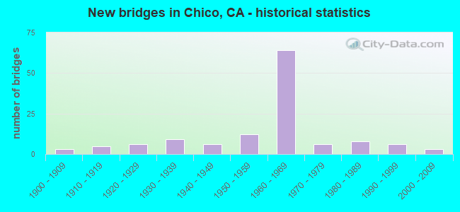
- New bridges - historical statistics
- 31900-1909
- 51910-1919
- 61920-1929
- 91930-1939
- 61940-1949
- 121950-1959
- 641960-1969
- 61970-1979
- 81980-1989
- 61990-1999
- 32000-2009
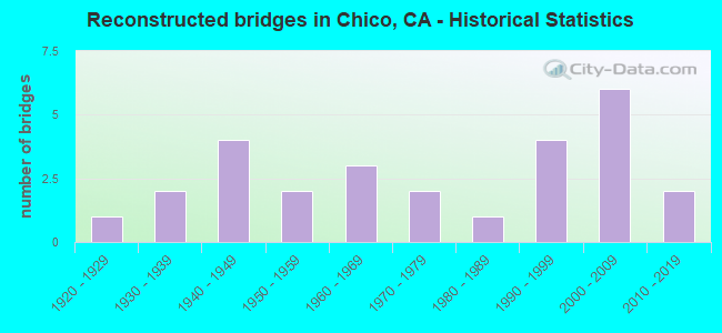
- Reconstructed bridges - Historical Statistics
- 11920-1929
- 21930-1939
- 41940-1949
- 21950-1959
- 31960-1969
- 21970-1979
- 11980-1989
- 41990-1999
- 62000-2009
- 22010-2019
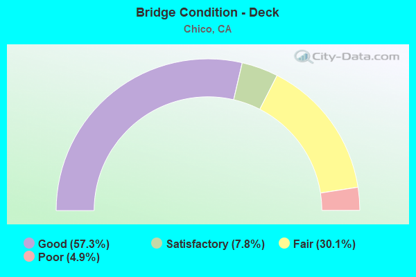
- Bridge Condition - Deck
- 57.3%Good
- 7.8%Satisfactory
- 30.1%Fair
- 4.9%Poor
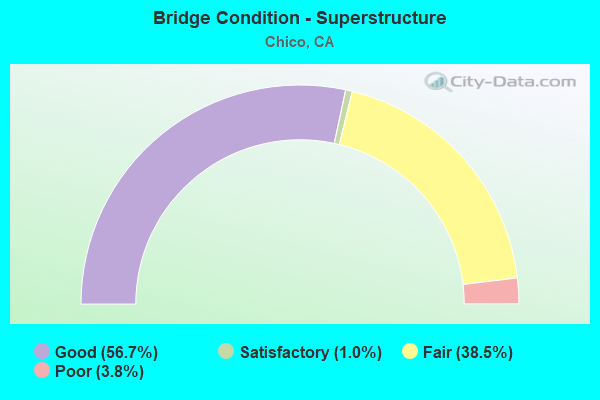
- Bridge Condition - Superstructure
- 56.7%Good
- 1.0%Satisfactory
- 38.5%Fair
- 3.8%Poor
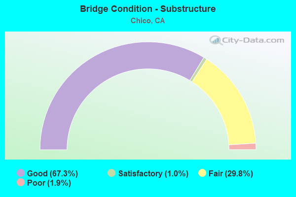
- Bridge Condition - Substructure
- 67.3%Good
- 1.0%Satisfactory
- 29.8%Fair
- 1.9%Poor
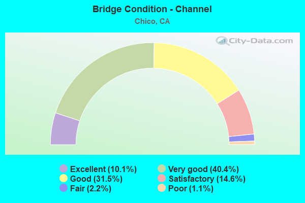
- Bridge Condition - Channel
- 10.1%Excellent
- 40.4%Very good
- 31.5%Good
- 14.6%Satisfactory
- 2.2%Fair
- 1.1%Poor
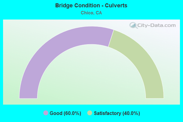
- Bridge Condition - Culverts
- 60.0%Good
- 40.0%Satisfactory
Find on map >> Show street view
Structure Number: 12C0299, Location: N/O 6TH ST (Lat: 39.743233, Lng: -121.792158), Route carried "on" structure: City street , Year Built: 1981, Year Reconstructed: 2006, Status: Open, Structure Length: 1.32m (4.33ft), Average Daily Traffic: 14,500 (year 2015), Truck Traffic: 4%, Average Future Daily Traffic: 18,547 (year 2038), Features Intersected: S FORK DEAD HORSE SLOUGH, Facility Carried by Structure: BRUCE ROAD
Minimum Vertical Clearance: 30+ m (98+ ft), Kilometerpoint: 0.000, Lanes on structure: 4, Owner: City or Municipal Highway Agency, Approaching Roadway Width: 22.5m (73.8ft), Skew: 20 degrees, Material/Design: Concrete continuous, Design/Construction: Culvert, Number Of Spans In Main Unit: 4, Length of Maximum Span: 3.3m (10.8ft), Curb or Sidewalk Widths: Left: 1.5m (4.9ft), Right: 1.5m (4.9ft), Curb-To-Curb Width: 22.5m (73.8ft), Out-to-Out Width: 26.2m (86.0ft)
Condition: Channel: Very good, Culverts: Satisfactory, Operating Rating: 54.1 metric tons, Method Used To Determine Operating Rating: Field evaluation and documented engineering judgment, Inventory Rating: 32.4 metric tons, Method Used To Determine Inventory Rating: Field evaluation and documented engineering judgment, Structural Evaluation: Equal to present minimum criteria, Deck Geometry: Superior to present desirable criteria, Waterway Adequacy: Equal to present minimum criteria, Approach Roadway Alignment: Equal to present desirable criteria, Designated Inspection Frequency: Every 48 months, Inspection Date: October 2018, Deck Structure Type: Concrete Cast-file-Place, Wearing Surface/Protective System: Wearing Surface: Bituminous
Find on map >> Show street view
Structure Number: 12C031, Location: 0.55 MI W HMTN ND CA HY (Lat: 39.781233, Lng: -121.965275), Route carried "on" structure: County highway , Year Built: 1940, Status: Open, Structure Length: 1.25m (4.10ft), Average Daily Traffic: 83 (year 2018), Truck Traffic: 8%, Average Future Daily Traffic: 303 (year 2042), Features Intersected: ROCK CREEK, Facility Carried by Structure: NORD GIANELLA RD
Minimum Vertical Clearance: 30+ m (98+ ft), Kilometerpoint: 0.000, Lanes on structure: 2, Owner: County Highway Agency, Approaching Roadway Width: 5.5m (18.0ft), Material/Design: Concrete continuous, Design/Construction: Tee Beam, Number Of Spans In Main Unit: 2, Length of Maximum Span: 5.8m (19.0ft), Curb or Sidewalk Widths: Left: 0.3m (1.0ft), Right: 0.3m (1.0ft), Curb-To-Curb Width: 6.4m (21.0ft), Out-to-Out Width: 7.1m (23.3ft)
Condition: Deck: Good, Superstructure: Fair, Substructure: Fair, Channel: Satisfactory, Operating Rating: 27.5 metric tons, Method Used To Determine Operating Rating: Field evaluation and documented engineering judgment, Inventory Rating: 16.5 metric tons, Method Used To Determine Inventory Rating: Field evaluation and documented engineering judgment, Structural Evaluation: Somewhat better than minimum adequacy, Deck Geometry: Somewhat better than minimum adequacy, Waterway Adequacy: Equal to present desirable criteria, Approach Roadway Alignment: Equal to present desirable criteria, Designated Inspection Frequency: Every 24 months, Inspection Date: July 2020, Deck Structure Type: Concrete Cast-file-Place, Wearing Surface/Protective System: Wearing Surface: Bituminous
Find on map >> Show street view
Structure Number: 12C0311, Location: 3.4 MI E/O HAMILT NORD CA (Lat: 39.775597, Lng: -121.893747), Route carried "on" structure: County highway , Year Built: 1962, Status: Open, Structure Length: 7.75m (25.43ft), Average Daily Traffic: 3,200 (year 2015), Truck Traffic: 5%, Average Future Daily Traffic: 2,173 (year 2040), Design Load: H 20, Features Intersected: MUD CREEK, Facility Carried by Structure: NORD HWY
Minimum Vertical Clearance: 30+ m (98+ ft), Kilometerpoint: 0.000, Lanes on structure: 2, Owner: City or Municipal Highway Agency, Approaching Roadway Width: 8.5m (27.9ft), Skew: 3 degrees, Material/Design: Concrete continuous, Design/Construction: Slab, Number Of Spans In Main Unit: 9, Length of Maximum Span: 8.6m (28.2ft), Curb-To-Curb Width: 7.9m (25.9ft), Out-to-Out Width: 8.1m (26.6ft)
Condition: Deck: Good, Superstructure: Good, Substructure: Good, Channel: Good, Operating Rating: 33.4 metric tons, Method Used To Determine Operating Rating: Load and Resistance Factor Rating (LRFR) rating reported by rating factor(RF) method using HL-93 loadings, Inventory Rating: 23.7 metric tons, Method Used To Determine Inventory Rating: Load and Resistance Factor Rating (LRFR) rating reported by rating factor(RF) method using HL-93 loadings, Structural Evaluation: Equal to present minimum criteria, Deck Geometry: High priority of corrective action, Waterway Adequacy: Superior to present desirable criteria, Approach Roadway Alignment: Equal to present minimum criteria, Designated Inspection Frequency: Every 24 months, Inspection Date: October 2020, Deck Structure Type: Concrete Cast-file-Place, Wearing Surface/Protective System: Wearing Surface: Bituminous
Find on map >> Show street view
Structure Number: 12C0313, Location: 0.1 MI N OF HWY 32 (Lat: 39.754778, Lng: -121.919025), Route carried "on" structure: County highway , Year Built: 1935, Status: Open, Structure Length: 0.70m (2.30ft), Average Daily Traffic: 1,820 (year 2011), Truck Traffic: 15%, Average Future Daily Traffic: 1,744 (year 2042), Features Intersected: GRASSY BANKS DITCH, Facility Carried by Structure: MERIDIAN RD
Minimum Vertical Clearance: 30+ m (98+ ft), Kilometerpoint: 0.000, Lanes on structure: 2, Owner: County Highway Agency, Approaching Roadway Width: 6.7m (22.0ft), Material/Design: Concrete, Design/Construction: Slab, Number Of Spans In Main Unit: 2, Length of Maximum Span: 3.4m (11.2ft), Curb-To-Curb Width: 6.9m (22.6ft), Out-to-Out Width: 7.0m (23.0ft)
Condition: Deck: Fair, Superstructure: Fair, Substructure: Fair, Channel: Excellent, Operating Rating: 26.9 metric tons, Method Used To Determine Operating Rating: Field evaluation and documented engineering judgment, Inventory Rating: 16.2 metric tons, Method Used To Determine Inventory Rating: Field evaluation and documented engineering judgment, Structural Evaluation: Meets minimum limits, Deck Geometry: High priority of corrective action, Waterway Adequacy: Equal to present desirable criteria, Approach Roadway Alignment: Equal to present desirable criteria, Designated Inspection Frequency: Every 24 months, Inspection Date: July 2020, Deck Structure Type: Concrete Cast-file-Place, Wearing Surface/Protective System: Wearing Surface: Bituminous
Find on map >> Show street view
Structure Number: 12C0314, Location: 0.77 MI N/O SACRAMENTO AV (Lat: 39.741167, Lng: -121.903253), Route carried "on" structure: County highway , Year Built: 1936, Status: Open, Structure Length: 1.33m (4.36ft), Average Daily Traffic: 225 (year 2011), Truck Traffic: 8%, Average Future Daily Traffic: 365 (year 2042), Features Intersected: CHANNEL SLOUGH, Facility Carried by Structure: MUIR RD
Minimum Vertical Clearance: 30+ m (98+ ft), Kilometerpoint: 0.000, Lanes on structure: 2, Owner: County Highway Agency, Approaching Roadway Width: 4.9m (16.1ft), Skew: 2 degrees, Material/Design: Concrete continuous, Design/Construction: Tee Beam, Number Of Spans In Main Unit: 2, Length of Maximum Span: 6.5m (21.3ft), Curb or Sidewalk Widths: Left: 0.4m (1.3ft), Right: 0.4m (1.3ft), Curb-To-Curb Width: 6.4m (21.0ft), Out-to-Out Width: 7.1m (23.3ft)
Condition: Deck: Good, Superstructure: Fair, Substructure: Fair, Channel: Poor, Operating Rating: 53.5 metric tons, Method Used To Determine Operating Rating: Load Factor (LF), Inventory Rating: 32.1 metric tons, Method Used To Determine Inventory Rating: Load Factor (LF), Structural Evaluation: Somewhat better than minimum adequacy, Deck Geometry: Meets minimum limits, Waterway Adequacy: Equal to present desirable criteria, Approach Roadway Alignment: Equal to present minimum criteria, Designated Inspection Frequency: Every 24 months, Inspection Date: July 2020, Deck Structure Type: Concrete Cast-file-Place, Wearing Surface/Protective System: Wearing Surface: Bituminous
Find on map >> Show street view
Structure Number: 12C0316, Location: 3.66 MI N ORD FERRY RD (Lat: 39.676028, Lng: -121.933078), Route carried "on" structure: County highway , Year Built: 1931, Status: Open, Structure Length: 0.98m (3.22ft), Average Daily Traffic: 1,256 (year 2006), Truck Traffic: 8%, Average Future Daily Traffic: 804 (year 2040), Features Intersected: SHADY OAKS SLOUGH, Facility Carried by Structure: RIVER RD
Minimum Vertical Clearance: 30+ m (98+ ft), Kilometerpoint: 0.000, Lanes on structure: 2, Owner: County Highway Agency, Approaching Roadway Width: 7.8m (25.6ft), Material/Design: Steel, Design/Construction: Stringer/Multi-beam, Number Of Spans In Main Unit: 2, Length of Maximum Span: 4.6m (15.1ft), Curb or Sidewalk Widths: Left: 0.3m (1.0ft), Right: 0.0m, Curb-To-Curb Width: 8.4m (27.6ft), Out-to-Out Width: 8.7m (28.5ft)
Condition: Deck: Good, Superstructure: Fair, Substructure: Fair, Channel: Good, Operating Rating: 24.9 metric tons, Method Used To Determine Operating Rating: Load Factor (LF), Inventory Rating: 14.9 metric tons, Method Used To Determine Inventory Rating: Load Factor (LF), Structural Evaluation: Meets minimum limits, Deck Geometry: Meets minimum limits, Waterway Adequacy: Equal to present minimum criteria, Approach Roadway Alignment: Equal to present minimum criteria, Designated Inspection Frequency: Every 24 months, Other Special Inspection Frequency: Every 48 months, Inspection Date: April 2020, Other Special Inspection Date: April 2020, Deck Structure Type: Concrete Cast-file-Place, Wearing Surface/Protective System: Wearing Surface: Bituminous
Find on map >> Show street view
Structure Number: 12C0319, Location: 0.25 MI S KEEFER RD (Lat: 39.815681, Lng: -121.876853), Route carried "on" structure: County highway , Year Built: 1940, Status: Open, Structure Length: 1.56m (5.12ft), Average Daily Traffic: 2,900 (year 2015), Truck Traffic: 10%, Average Future Daily Traffic: 435 (year 2040), Features Intersected: KEEFER SLOUGH, Facility Carried by Structure: HICKS LANE
Minimum Vertical Clearance: 30+ m (98+ ft), Kilometerpoint: 0.000, Lanes on structure: 2, Owner: County Highway Agency, Approaching Roadway Width: 6.4m (21.0ft), Material/Design: Concrete continuous, Design/Construction: Slab, Number Of Spans In Main Unit: 5, Length of Maximum Span: 3.0m (9.8ft), Curb-To-Curb Width: 7.0m (23.0ft), Out-to-Out Width: 7.1m (23.3ft)
Condition: Deck: Fair, Superstructure: Fair, Substructure: Fair, Channel: Good, Operating Rating: 26.9 metric tons, Method Used To Determine Operating Rating: Field evaluation and documented engineering judgment, Inventory Rating: 16.2 metric tons, Method Used To Determine Inventory Rating: Field evaluation and documented engineering judgment, Structural Evaluation: Meets minimum limits, Deck Geometry: High priority of replacement, Waterway Adequacy: Equal to present desirable criteria, Approach Roadway Alignment: Equal to present minimum criteria, Designated Inspection Frequency: Every 24 months, Inspection Date: October 2020, Deck Structure Type: Concrete Cast-file-Place, Wearing Surface/Protective System: Wearing Surface: Bituminous
Find on map >> Show street view
Structure Number: 12C032, Location: 0.5 MI N/O EATON RD (Lat: 39.783147, Lng: -121.872169), Route carried "on" structure: County highway , Year Built: 1962, Status: Open, Structure Length: 6.89m (22.60ft), Average Daily Traffic: 3,000 (year 2018), Truck Traffic: 12%, Average Future Daily Traffic: 520 (year 2040), Design Load: H 20, Features Intersected: SYCAMORE CREEK, Facility Carried by Structure: HICKS LANE
Minimum Vertical Clearance: 30+ m (98+ ft), Kilometerpoint: 0.000, Lanes on structure: 2, Owner: City or Municipal Highway Agency, Approaching Roadway Width: 7.9m (25.9ft), Skew: 1 degrees, Material/Design: Concrete continuous, Design/Construction: Slab, Number Of Spans In Main Unit: 8, Length of Maximum Span: 8.5m (27.9ft), Curb-To-Curb Width: 7.9m (25.9ft), Out-to-Out Width: 8.1m (26.6ft)
Condition: Deck: Good, Superstructure: Good, Substructure: Good, Channel: Very good, Operating Rating: 58.6 metric tons, Method Used To Determine Operating Rating: Load Factor (LF), Inventory Rating: 35.3 metric tons, Method Used To Determine Inventory Rating: Load Factor (LF), Structural Evaluation: Better than present minimum criteria, Deck Geometry: High priority of corrective action, Waterway Adequacy: Equal to present desirable criteria, Approach Roadway Alignment: Equal to present minimum criteria, Designated Inspection Frequency: Every 48 months, Inspection Date: October 2018, Deck Structure Type: Concrete Cast-file-Place
Find on map >> Show street view
Structure Number: 12C0321, Location: 0.01 MI NW OF ROCK CR RD (Lat: 39.843878, Lng: -121.836089), Route carried "on" structure: County highway , Year Built: 1926, Year Reconstructed: 1949, Status: Open, Structure Length: 3.66m (12.01ft), Average Daily Traffic: 20 (year 2016), Average Future Daily Traffic: 65 (year 2037), Features Intersected: ROCK CREEK, Facility Carried by Structure: ROCK CREEK DRIVE
Minimum Vertical Clearance: 30+ m (98+ ft), Kilometerpoint: 0.000, Lanes on structure: 2, Owner: County Highway Agency, Approaching Roadway Width: 4.3m (14.1ft), Material/Design: Steel, Design/Construction: Stringer/Multi-beam, Number Of Spans In Main Unit: 4, Length of Maximum Span: 9.2m (30.2ft), Curb or Sidewalk Widths: Left: 0.3m (1.0ft), Right: 0.3m (1.0ft), Curb-To-Curb Width: 5.6m (18.4ft), Out-to-Out Width: 6.2m (20.3ft)
Condition: Deck: Fair, Superstructure: Fair, Substructure: Fair, Channel: Very good, Operating Rating: 27.9 metric tons, Method Used To Determine Operating Rating: Load and Resistance Factor Rating (LRFR) rating reported by rating factor(RF) method using HL-93 loadings, Inventory Rating: 21.4 metric tons, Method Used To Determine Inventory Rating: Load and Resistance Factor Rating (LRFR) rating reported by rating factor(RF) method using HL-93 loadings, Structural Evaluation: Somewhat better than minimum adequacy, Deck Geometry: Meets minimum limits, Waterway Adequacy: Equal to present desirable criteria, Approach Roadway Alignment: Equal to present minimum criteria, Designated Inspection Frequency: Every 24 months, Critical Feature Inspection Frequency: Every 24 months, Inspection Date: July 2020, Critical Feature Inspection Date: July 2020, Deck Structure Type: Concrete Cast-file-Place
Find on map >> Show street view
Structure Number: 12C0323, Location: JUST W OF GRAPE WAY (Lat: 39.730019, Lng: -121.901950), Route carried "on" structure: County highway , Year Built: 1967, Status: Open, Structure Length: 3.06m (10.04ft), Average Daily Traffic: 1,048 (year 2011), Truck Traffic: 7%, Average Future Daily Traffic: 2,088 (year 2042), Design Load: HS 20, Features Intersected: SANDY GULCH, Facility Carried by Structure: SACRAMENTO AVE
Minimum Vertical Clearance: 30+ m (98+ ft), Kilometerpoint: 0.000, Lanes on structure: 2, Owner: County Highway Agency, Approaching Roadway Width: 6.1m (20.0ft), Skew: 3 degrees, Material/Design: Concrete continuous, Design/Construction: Slab, Number Of Spans In Main Unit: 4, Length of Maximum Span: 8.6m (28.2ft), Curb-To-Curb Width: 8.5m (27.9ft), Out-to-Out Width: 8.7m (28.5ft)
Condition: Deck: Fair, Superstructure: Fair, Substructure: Good, Channel: Very good, Operating Rating: 59.6 metric tons, Method Used To Determine Operating Rating: Load Factor (LF), Inventory Rating: 36.0 metric tons, Method Used To Determine Inventory Rating: Load Factor (LF), Structural Evaluation: Somewhat better than minimum adequacy, Deck Geometry: Somewhat better than minimum adequacy, Waterway Adequacy: Equal to present desirable criteria, Approach Roadway Alignment: Equal to present minimum criteria, Designated Inspection Frequency: Every 24 months, Inspection Date: July 2020, Deck Structure Type: Concrete Cast-file-Place, Wearing Surface/Protective System: Wearing Surface: Bituminous
Find on map >> Show street view
Structure Number: 12C0324, Location: 0.5 MI W GLENWOOD AVE (Lat: 39.735492, Lng: -121.891022), Route carried "on" structure: County highway , Year Built: 1906, Year Reconstructed: 1936, Status: Open, Structure Length: 1.80m (5.91ft), Average Daily Traffic: 325 (year 2011), Truck Traffic: 7%, Average Future Daily Traffic: 626 (year 2042), Features Intersected: SANDY GULCH, Facility Carried by Structure: OAK WAY
Minimum Vertical Clearance: 30+ m (98+ ft), Kilometerpoint: 0.000, Lanes on structure: 2, Owner: County Highway Agency, Approaching Roadway Width: 5.8m (19.0ft), Skew: 9 degrees, Material/Design: Steel, Design/Construction: Stringer/Multi-beam, Number Of Spans In Main Unit: 1, Number Of Approach Spans: 2, Length of Maximum Span: 13.6m (44.6ft), Curb or Sidewalk Widths: Left: 0.5m (1.6ft), Right: 0.5m (1.6ft), Curb-To-Curb Width: 7.3m (24.0ft), Out-to-Out Width: 8.3m (27.2ft)
Condition: Deck: Good, Superstructure: Fair, Substructure: Poor, Channel: Very good, Operating Rating: 29.5 metric tons, Method Used To Determine Operating Rating: Load Factor (LF), Inventory Rating: 17.8 metric tons, Method Used To Determine Inventory Rating: Load Factor (LF), Structural Evaluation: Meets minimum limits, Deck Geometry: Somewhat better than minimum adequacy, Waterway Adequacy: Equal to present desirable criteria, Approach Roadway Alignment: Equal to present desirable criteria, Length Of Structure Improvement: 1.77m (5.81ft), Designated Inspection Frequency: Every 24 months, Inspection Date: July 2020, Bridge Improvement Cost: $338,000, Roadway Improvement Cost: $67,000, Total Project Cost: $568,000 ( Estimate for 2020), Deck Structure Type: Concrete Cast-file-Place, Wearing Surface/Protective System: Wearing Surface: Bituminous
Find on map >> Show street view
Structure Number: 12C0325, Location: AT BIDWELL AVENUE (Lat: 39.726997, Lng: -121.863308), Route carried "on" structure: County highway , Year Built: 1925, Status: Open, Structure Length: 2.01m (6.59ft), Average Daily Traffic: 1,013 (year 2006), Truck Traffic: 6%, Average Future Daily Traffic: 1,750 (year 2042), Features Intersected: BIG CHICO CREEK, Facility Carried by Structure: ROSE AVE
Minimum Vertical Clearance: 30+ m (98+ ft), Kilometerpoint: 0.000, Lanes on structure: 1, Owner: County Highway Agency, Approaching Roadway Width: 5.5m (18.0ft), Material/Design: Concrete continuous, Design/Construction: Tee Beam, Number Of Spans In Main Unit: 3, Length of Maximum Span: 9.6m (31.5ft), Curb or Sidewalk Widths: Left: 0.1m (0.3ft), Right: 0.1m (0.3ft), Curb-To-Curb Width: 6.3m (20.7ft), Out-to-Out Width: 7.1m (23.3ft)
Condition: Deck: Good, Superstructure: Fair, Substructure: Fair, Channel: Good, Operating Rating: 24.9 metric tons, Method Used To Determine Operating Rating: Load and Resistance Factor Rating (LRFR) rating reported by rating factor(RF) method using HL-93 loadings, Inventory Rating: 19.1 metric tons, Method Used To Determine Inventory Rating: Load and Resistance Factor Rating (LRFR) rating reported by rating factor(RF) method using HL-93 loadings, Structural Evaluation: Somewhat better than minimum adequacy, Deck Geometry: High priority of replacement, Waterway Adequacy: Superior to present desirable criteria, Approach Roadway Alignment: Equal to present minimum criteria, Designated Inspection Frequency: Every 24 months, Inspection Date: October 2020, Deck Structure Type: Concrete Cast-file-Place, Wearing Surface/Protective System: Wearing Surface: Bituminous
Find on map >> Show street view
Structure Number: 12C0327, Location: 0.5 MI S CHICO RIVER RD (Lat: 39.700569, Lng: -121.882636), Route carried "on" structure: County highway , Year Built: 1939, Status: Open, Structure Length: 1.25m (4.10ft), Average Daily Traffic: 330 (year 2011), Truck Traffic: 18%, Average Future Daily Traffic: 730 (year 2042), Features Intersected: LITTLE CHICO CREEK, Facility Carried by Structure: CROUCH AVE
Minimum Vertical Clearance: 30+ m (98+ ft), Kilometerpoint: 0.000, Lanes on structure: 2, Owner: County Highway Agency, Approaching Roadway Width: 5.2m (17.1ft), Skew: 2 degrees, Material/Design: Steel, Design/Construction: Stringer/Multi-beam, Number Of Spans In Main Unit: 1, Length of Maximum Span: 11.9m (39.0ft), Curb or Sidewalk Widths: Left: 0.5m (1.6ft), Right: 0.5m (1.6ft), Curb-To-Curb Width: 7.3m (24.0ft), Out-to-Out Width: 8.3m (27.2ft)
Condition: Deck: Fair, Superstructure: Fair, Substructure: Fair, Channel: Good, Operating Rating: 48.3 metric tons, Method Used To Determine Operating Rating: Load Factor (LF), Inventory Rating: 28.8 metric tons, Method Used To Determine Inventory Rating: Load Factor (LF), Structural Evaluation: Somewhat better than minimum adequacy, Deck Geometry: Somewhat better than minimum adequacy, Waterway Adequacy: Better than present minimum criteria, Approach Roadway Alignment: Equal to present desirable criteria, Designated Inspection Frequency: Every 24 months, Inspection Date: July 2020, Deck Structure Type: Concrete Cast-file-Place, Wearing Surface/Protective System: Wearing Surface: Bituminous
Find on map >> Show street view
Structure Number: 12C0328, Location: 0.4 MI SE/O MILLER AVE (Lat: 39.716306, Lng: -121.845572), Route carried "on" structure: County highway , Year Built: 1917, Status: Open, Structure Length: 2.02m (6.63ft), Average Daily Traffic: 1,100 (year 2000), Truck Traffic: 3%, Average Future Daily Traffic: 1,641 (year 2042), Features Intersected: LITTLE CHICO CREEK, Facility Carried by Structure: POMONA ROAD
Minimum Vertical Clearance: 30+ m (98+ ft), Kilometerpoint: 0.000, Lanes on structure: 2, Owner: City or Municipal Highway Agency, Approaching Roadway Width: 9.4m (30.8ft), Skew: 2 degrees, Material/Design: Concrete continuous, Design/Construction: Tee Beam, Number Of Spans In Main Unit: 3, Length of Maximum Span: 9.2m (30.2ft), Curb or Sidewalk Widths: Left: 0.3m (1.0ft), Right: 0.3m (1.0ft), Curb-To-Curb Width: 6.2m (20.3ft), Out-to-Out Width: 6.8m (22.3ft)
Condition: Deck: Good, Superstructure: Good, Substructure: Fair, Channel: Satisfactory, Operating Rating: 25.9 metric tons, Method Used To Determine Operating Rating: Field evaluation and documented engineering judgment, Inventory Rating: 15.6 metric tons, Method Used To Determine Inventory Rating: Field evaluation and documented engineering judgment, Structural Evaluation: Meets minimum limits, Deck Geometry: High priority of replacement, Waterway Adequacy: Equal to present minimum criteria, Approach Roadway Alignment: Equal to present desirable criteria, Designated Inspection Frequency: Every 24 months, Inspection Date: October 2020, Deck Structure Type: Concrete Cast-file-Place, Wearing Surface/Protective System: Wearing Surface: Bituminous
Find on map >> Show street view
Structure Number: 12C033, Location: 2.60 MI N OF NELSON RD (Lat: 39.588542, Lng: -121.800439), Route carried "on" structure: County highway , Year Built: 1937, Status: Open, Structure Length: 1.68m (5.51ft), Average Daily Traffic: 44 (year 2017), Truck Traffic: 17%, Average Future Daily Traffic: 116 (year 2041), Features Intersected: HANLON SLOUGH, Facility Carried by Structure: DURNEL RD
Minimum Vertical Clearance: 30+ m (98+ ft), Kilometerpoint: 0.000, Lanes on structure: 2, Owner: County Highway Agency, Approaching Roadway Width: 5.2m (17.1ft), Skew: 5 degrees, Material/Design: Steel, Design/Construction: Stringer/Multi-beam, Number Of Spans In Main Unit: 2, Length of Maximum Span: 7.6m (24.9ft), Curb or Sidewalk Widths: Left: 0.2m (0.7ft), Right: 0.2m (0.7ft), Curb-To-Curb Width: 8.0m (26.2ft), Out-to-Out Width: 9.1m (29.9ft)
Condition: Deck: Good, Superstructure: Fair, Substructure: Fair, Channel: Good, Operating Rating: 99.8 metric tons, Method Used To Determine Operating Rating: Load Factor (LF), Inventory Rating: 63.5 metric tons, Method Used To Determine Inventory Rating: Load Factor (LF), Structural Evaluation: Somewhat better than minimum adequacy, Deck Geometry: Equal to present minimum criteria, Waterway Adequacy: Better than present minimum criteria, Approach Roadway Alignment: Equal to present minimum criteria, Designated Inspection Frequency: Every 24 months, Inspection Date: November 2020, Deck Structure Type: Concrete Cast-file-Place, Wearing Surface/Protective System: Wearing Surface: Bituminous
Find on map >> Show street view
Structure Number: 12C0335, Location: AT W 9TH ST (Lat: 39.722722, Lng: -121.838192), Route carried "on" structure: City street , Year Built: 1980, Status: Open, Structure Length: 2.36m (7.74ft), Average Daily Traffic: 1,700 (year 2000), Truck Traffic: 3%, Average Future Daily Traffic: 2,896 (year 2036), Design Load: HS 20, Features Intersected: LITTLE CHICO CREEK, Facility Carried by Structure: CHESTNUT ST
Minimum Vertical Clearance: 30+ m (98+ ft), Kilometerpoint: 0.000, Lanes on structure: 2, Owner: City or Municipal Highway Agency, Approaching Roadway Width: 12.2m (40.0ft), Material/Design: Concrete continuous, Design/Construction: Slab, Number Of Spans In Main Unit: 3, Length of Maximum Span: 9.1m (29.9ft), Curb or Sidewalk Widths: Left: 1.5m (4.9ft), Right: 1.5m (4.9ft), Curb-To-Curb Width: 12.2m (40.0ft), Out-to-Out Width: 15.8m (51.8ft)
Condition: Deck: Good, Superstructure: Good, Substructure: Good, Channel: Good, Operating Rating: 75.5 metric tons, Method Used To Determine Operating Rating: Load Factor (LF), Inventory Rating: 45.4 metric tons, Method Used To Determine Inventory Rating: Load Factor (LF), Structural Evaluation: Better than present minimum criteria, Deck Geometry: Better than present minimum criteria, Waterway Adequacy: Equal to present desirable criteria, Approach Roadway Alignment: Equal to present desirable criteria, Designated Inspection Frequency: Every 48 months, Inspection Date: October 2018, Deck Structure Type: Concrete Cast-file-Place
Find on map >> Show street view
Structure Number: 12C0336, Location: 0.1 MI N OF 10TH ST (Lat: 39.723847, Lng: -121.836164), Route carried "on" structure: City street , Year Built: 1916, Status: Open, Structure Length: 1.95m (6.40ft), Average Daily Traffic: 5,200 (year 2000), Truck Traffic: 3%, Average Future Daily Traffic: 6,265 (year 2042), Features Intersected: LITTLE CHICO CREEK, Facility Carried by Structure: SALEM STREET
Minimum Vertical Clearance: 30+ m (98+ ft), Kilometerpoint: 0.000, Lanes on structure: 2, Owner: City or Municipal Highway Agency, Approaching Roadway Width: 10.2m (33.5ft), Material/Design: Concrete continuous, Design/Construction: Tee Beam, Number Of Spans In Main Unit: 3, Length of Maximum Span: 10.4m (34.1ft), Curb or Sidewalk Widths: Left: 1.4m (4.6ft), Right: 1.4m (4.6ft), Curb-To-Curb Width: 6.8m (22.3ft), Out-to-Out Width: 10.0m (32.8ft)
Condition: Deck: Fair, Superstructure: Good, Substructure: Fair, Channel: Satisfactory, Operating Rating: 39.5 metric tons, Method Used To Determine Operating Rating: Load and Resistance Factor Rating (LRFR) rating reported by rating factor(RF) method using HL-93 loadings, Inventory Rating: 30.5 metric tons, Method Used To Determine Inventory Rating: Load and Resistance Factor Rating (LRFR) rating reported by rating factor(RF) method using HL-93 loadings, Structural Evaluation: Somewhat better than minimum adequacy, Deck Geometry: High priority of replacement, Waterway Adequacy: Equal to present desirable criteria, Approach Roadway Alignment: Equal to present minimum criteria, Designated Inspection Frequency: Every 24 months, Inspection Date: October 2020, Deck Structure Type: Concrete Cast-file-Place, Wearing Surface/Protective System: Wearing Surface: Bituminous
Find on map >> Show street view
Structure Number: 12C0337, Location: S OF 9TH ST (Lat: 39.724269, Lng: -121.835075), Route carried "on" structure: City street , Year Built: 1920, Year Reconstructed: 1930, Status: Open, Structure Length: 1.53m (5.02ft), Average Daily Traffic: 4,000 (year 2000), Truck Traffic: 3%, Average Future Daily Traffic: 5,361 (year 2042), Features Intersected: LITTLE CHICO CREEK, Facility Carried by Structure: BROADWAY ST
Minimum Vertical Clearance: 30+ m (98+ ft), Kilometerpoint: 0.000, Lanes on structure: 2, Owner: City or Municipal Highway Agency, Approaching Roadway Width: 15.0m (49.2ft), Skew: 3 degrees, Material/Design: Concrete, Design/Construction: Tee Beam, Number Of Spans In Main Unit: 1, Length of Maximum Span: 14.6m (47.9ft), Curb or Sidewalk Widths: Left: 1.3m (4.3ft), Right: 1.2m (3.9ft), Curb-To-Curb Width: 10.5m (34.4ft), Out-to-Out Width: 13.7m (44.9ft)
Condition: Deck: Fair, Superstructure: Fair, Substructure: Fair, Channel: Satisfactory, Operating Rating: 40.2 metric tons, Method Used To Determine Operating Rating: Load Factor (LF), Inventory Rating: 24.0 metric tons, Method Used To Determine Inventory Rating: Load Factor (LF), Structural Evaluation: Somewhat better than minimum adequacy, Deck Geometry: Somewhat better than minimum adequacy, Waterway Adequacy: Equal to present minimum criteria, Approach Roadway Alignment: Equal to present minimum criteria, Designated Inspection Frequency: Every 24 months, Inspection Date: October 2020, Deck Structure Type: Concrete Cast-file-Place, Wearing Surface/Protective System: Wearing Surface: Bituminous
Find on map >> Show street view
Structure Number: 12C0338, Location: 0.1 MI N OF 12TH ST (Lat: 39.728203, Lng: -121.825717), Route carried "on" structure: City street , Year Built: 1950, Status: Open, Structure Length: 1.74m (5.71ft), Average Daily Traffic: 2,500 (year 2000), Truck Traffic: 3%, Average Future Daily Traffic: 3,133 (year 2042), Features Intersected: LITTLE CHICO CREEK, Facility Carried by Structure: MILL ST
Minimum Vertical Clearance: 30+ m (98+ ft), Kilometerpoint: 0.000, Lanes on structure: 2, Owner: City or Municipal Highway Agency, Approaching Roadway Width: 10.4m (34.1ft), Material/Design: Concrete, Design/Construction: Tee Beam, Number Of Spans In Main Unit: 1, Length of Maximum Span: 17.1m (56.1ft), Curb or Sidewalk Widths: Left: 0.2m (0.7ft), Right: 1.0m (3.3ft), Curb-To-Curb Width: 7.3m (24.0ft), Out-to-Out Width: 9.1m (29.9ft)
Condition: Deck: Fair, Superstructure: Good, Substructure: Good, Channel: Good, Operating Rating: 19.4 metric tons, Method Used To Determine Operating Rating: Load and Resistance Factor Rating (LRFR) rating reported by rating factor(RF) method using HL-93 loadings, Inventory Rating: 15.2 metric tons, Method Used To Determine Inventory Rating: Load and Resistance Factor Rating (LRFR) rating reported by rating factor(RF) method using HL-93 loadings, Structural Evaluation: Meets minimum limits, Deck Geometry: High priority of replacement, Waterway Adequacy: Equal to present desirable criteria, Approach Roadway Alignment: Equal to present desirable criteria, Designated Inspection Frequency: Every 24 months, Inspection Date: October 2020, Deck Structure Type: Concrete Cast-file-Place
Find on map >> Show street view
Structure Number: 12C036, Location: N OF LA PORTE RD (Lat: 39.335992, Lng: -121.491400), Route carried "on" structure: County highway , Year Built: 1970, Year Reconstructed: 2015, Status: Open, Structure Length: 0.91m (2.99ft), Average Daily Traffic: 3,000 (year 2019), Truck Traffic: 20%, Average Future Daily Traffic: 4,191 (year 2041), Features Intersected: WILSON CREEK, Facility Carried by Structure: DUNSTONE DRIVE
Minimum Vertical Clearance: 30+ m (98+ ft), Kilometerpoint: 0.000, Lanes on structure: 2, Owner: County Highway Agency, Approaching Roadway Width: 6.7m (22.0ft), Skew: 4 degrees, Material/Design: Steel, Design/Construction: Culvert, Number Of Spans In Main Unit: 4, Length of Maximum Span: 2.4m (7.9ft)
Condition: Channel: Very good, Culverts: Good, Operating Rating: 40.5 metric tons, Method Used To Determine Operating Rating: Field evaluation and documented engineering judgment, Inventory Rating: 24.3 metric tons, Method Used To Determine Inventory Rating: Field evaluation and documented engineering judgment, Structural Evaluation: Equal to present minimum criteria, Waterway Adequacy: Equal to present desirable criteria, Approach Roadway Alignment: Equal to present minimum criteria, Designated Inspection Frequency: Every 24 months, Inspection Date: July 2021
Find on map >> Show street view
Structure Number: 12C0363, Location: BTWN DAYTON RD & 9TH ST (Lat: 39.718314, Lng: -121.843339), Route carried "on" structure: City street , Year Built: 1982, Status: Open, Structure Length: 2.35m (7.71ft), Average Daily Traffic: 200 (year 2010), Average Future Daily Traffic: 834 (year 2042), Design Load: HS 20+Mod, Features Intersected: LITTLE CHICO CREEK, Facility Carried by Structure: WALNUT ST
Minimum Vertical Clearance: 30+ m (98+ ft), Kilometerpoint: 0.000, Lanes on structure: 2, Owner: City or Municipal Highway Agency, Approaching Roadway Width: 12.1m (39.7ft), Skew: 1 degrees, Material/Design: Concrete continuous, Design/Construction: Slab, Number Of Spans In Main Unit: 3, Length of Maximum Span: 9.2m (30.2ft), Curb or Sidewalk Widths: Left: 1.5m (4.9ft), Right: 1.5m (4.9ft), Curb-To-Curb Width: 12.1m (39.7ft), Out-to-Out Width: 15.8m (51.8ft)
Condition: Deck: Fair, Superstructure: Fair, Substructure: Good, Channel: Good, Operating Rating: 75.5 metric tons, Method Used To Determine Operating Rating: Load Factor (LF), Inventory Rating: 45.4 metric tons, Method Used To Determine Inventory Rating: Load Factor (LF), Structural Evaluation: Somewhat better than minimum adequacy, Deck Geometry: Superior to present desirable criteria, Waterway Adequacy: Equal to present desirable criteria, Approach Roadway Alignment: Equal to present minimum criteria, Designated Inspection Frequency: Every 24 months, Inspection Date: October 2020, Deck Structure Type: Concrete Cast-file-Place
Find on map >> Show street view
Structure Number: 12C0392, Location: 0.1 MI N SR 32 (Lat: 39.741378, Lng: -121.800186), Route carried "on" structure: County highway , Year Built: 1979, Status: Open, Structure Length: 2.20m (7.22ft), Average Daily Traffic: 628 (year 2007), Truck Traffic: 5%, Average Future Daily Traffic: 579 (year 2042), Design Load: HS 20, Features Intersected: DEAD HORSE SLOUGH, Facility Carried by Structure: EL MONTE AVE
Minimum Vertical Clearance: 30+ m (98+ ft), Kilometerpoint: 0.000, Lanes on structure: 2, Owner: County Highway Agency, Approaching Roadway Width: 8.8m (28.9ft), Skew: 3 degrees, Material/Design: Concrete continuous, Design/Construction: Slab, Number Of Spans In Main Unit: 3, Length of Maximum Span: 8.6m (28.2ft), Curb-To-Curb Width: 9.7m (31.8ft), Out-to-Out Width: 9.9m (32.5ft)
Condition: Deck: Fair, Superstructure: Fair, Substructure: Good, Channel: Very good, Operating Rating: 78.7 metric tons, Method Used To Determine Operating Rating: Load Factor (LF), Inventory Rating: 47.3 metric tons, Method Used To Determine Inventory Rating: Load Factor (LF), Structural Evaluation: Somewhat better than minimum adequacy, Deck Geometry: Equal to present minimum criteria, Waterway Adequacy: Equal to present desirable criteria, Approach Roadway Alignment: Equal to present desirable criteria, Designated Inspection Frequency: Every 24 months, Inspection Date: October 2020, Deck Structure Type: Concrete Cast-file-Place
Find on map >> Show street view
Structure Number: 12C041, Location: 0.2 MI W PALERMO RD (Lat: 39.466339, Lng: -121.528872), Route carried "on" structure: County highway , Year Built: 1988, Status: Open, Structure Length: 0.73m (2.40ft), Average Daily Traffic: 4,290 (year 2007), Truck Traffic: 9%, Average Future Daily Traffic: 1,817 (year 2041), Features Intersected: BRANCH WYMAN RAVINE, Facility Carried by Structure: OPHIR RD EXT
Minimum Vertical Clearance: 30+ m (98+ ft), Kilometerpoint: 0.000, Lanes on structure: 2, Owner: County Highway Agency, Approaching Roadway Width: 11.3m (37.1ft), Skew: 4 degrees, Material/Design: Concrete continuous, Design/Construction: Culvert, Number Of Spans In Main Unit: 2, Length of Maximum Span: 3.7m (12.1ft), Curb-To-Curb Width: 12.2m (40.0ft), Out-to-Out Width: 12.4m (40.7ft)
Condition: Channel: Satisfactory, Culverts: Good, Operating Rating: 54.1 metric tons, Method Used To Determine Operating Rating: Field evaluation and documented engineering judgment, Inventory Rating: 32.4 metric tons, Method Used To Determine Inventory Rating: Field evaluation and documented engineering judgment, Structural Evaluation: Better than present minimum criteria, Deck Geometry: Equal to present minimum criteria, Waterway Adequacy: Equal to present desirable criteria, Approach Roadway Alignment: Equal to present desirable criteria, Designated Inspection Frequency: Every 48 months, Inspection Date: May 2019, Deck Structure Type: Concrete Cast-file-Place, Wearing Surface/Protective System: Wearing Surface: Bituminous
Find on map >> Show street view
Structure Number: 12C0412, Location: 0.5 MI S OF W EAST AVE (Lat: 39.749078, Lng: -121.865453), Route carried "on" structure: City street , Year Built: 1996, Status: Open, Structure Length: 2.52m (8.27ft), Average Daily Traffic: 4,000 (year 1998), Truck Traffic: 3%, Average Future Daily Traffic: 6,520 (year 2042), Design Load: HS 20+Mod, Features Intersected: LINDO CHANNEL, Facility Carried by Structure: HOLLY AVE
Minimum Vertical Clearance: 30+ m (98+ ft), Kilometerpoint: 0.000, Lanes on structure: 3, Owner: City or Municipal Highway Agency, Approaching Roadway Width: 12.1m (39.7ft), Skew: 1 degrees, Material/Design: Prestressed concrete, Design/Construction: Box Beam or Girders - Multiple, Number Of Spans In Main Unit: 1, Length of Maximum Span: 24.4m (80.1ft), Curb or Sidewalk Widths: Left: 1.5m (4.9ft), Right: 1.5m (4.9ft), Curb-To-Curb Width: 12.1m (39.7ft), Out-to-Out Width: 15.8m (51.8ft)
Condition: Deck: Good, Superstructure: Good, Substructure: Good, Channel: Excellent, Operating Rating: 54.1 metric tons, Method Used To Determine Operating Rating: Assigned rating based on Load Factor Design (LFD) reported in metric tons, Inventory Rating: 32.4 metric tons, Method Used To Determine Inventory Rating: Assigned rating based on Load Factor Design (LFD) reported in metric tons, Structural Evaluation: Better than present minimum criteria, Deck Geometry: Meets minimum limits, Waterway Adequacy: Superior to present desirable criteria, Approach Roadway Alignment: Equal to present desirable criteria, Designated Inspection Frequency: Every 48 months, Inspection Date: October 2020, Deck Structure Type: Concrete Cast-file-Place
Find on map >> Show street view
Structure Number: 12C042, Location: 0.5 MI N SKYWAY (Lat: 39.885975, Lng: -121.612617), Route carried "on" structure: County highway , Year Built: 1968, Status: Open, Structure Length: 0.70m (2.30ft), Average Daily Traffic: 100 (year 2007), Truck Traffic: 1%, Average Future Daily Traffic: 217 (year 2042), Features Intersected: BUTTE CREEK CANAL, Facility Carried by Structure: DOE MILL ROAD
Minimum Vertical Clearance: 30+ m (98+ ft), Kilometerpoint: 0.000, Lanes on structure: 1, Owner: County Highway Agency, Approaching Roadway Width: 4.8m (15.7ft), Material/Design: Steel, Design/Construction: Stringer/Multi-beam, Number Of Spans In Main Unit: 1, Length of Maximum Span: 6.3m (20.7ft), Curb-To-Curb Width: 4.6m (15.1ft), Out-to-Out Width: 4.8m (15.7ft)
Condition: Deck: Fair, Superstructure: Fair, Substructure: Good, Channel: Excellent, Operating Rating: 28.5 metric tons, Method Used To Determine Operating Rating: Load and Resistance Factor Rating (LRFR) rating reported by rating factor(RF) method using HL-93 loadings, Inventory Rating: 22.0 metric tons, Method Used To Determine Inventory Rating: Load and Resistance Factor Rating (LRFR) rating reported by rating factor(RF) method using HL-93 loadings, Structural Evaluation: Somewhat better than minimum adequacy, Deck Geometry: Better than present minimum criteria, Waterway Adequacy: Equal to present desirable criteria, Approach Roadway Alignment: Equal to present minimum criteria, Designated Inspection Frequency: Every 24 months, Inspection Date: July 2020, Deck Structure Type: Concrete Precast Panels
Find on map >> Show street view
Structure Number: 12C0422, Location: 0.7 MI N/O EATON RD (Lat: 39.786600, Lng: -121.843872), Route carried "on" structure: City street , Year Built: 2008, Status: Open, Structure Length: 2.78m (9.12ft), Average Daily Traffic: 10,300 (year 2018), Truck Traffic: 3%, Average Future Daily Traffic: 15,612 (year 2040), Design Load: HS 20+Mod, Features Intersected: SYCAMORE CREEK TRIBUTARY, Facility Carried by Structure: COHASSET RD
Minimum Vertical Clearance: 30+ m (98+ ft), Kilometerpoint: 0.000, Lanes on structure: 2, Owner: City or Municipal Highway Agency, Approaching Roadway Width: 20.0m (65.6ft), Skew: 3 degrees, Material/Design: Concrete continuous, Design/Construction: Slab, Number Of Spans In Main Unit: 3, Length of Maximum Span: 11.0m (36.1ft), Curb or Sidewalk Widths: Left: 3.1m (10.2ft), Right: 0.0m, Curb-To-Curb Width: 19.5m (64.0ft), Out-to-Out Width: 24.0m (78.7ft)
Condition: Deck: Fair, Superstructure: Fair, Substructure: Good, Channel: Excellent, Operating Rating: 54.1 metric tons, Method Used To Determine Operating Rating: Assigned rating based on Load Factor Design (LFD) reported in metric tons, Inventory Rating: 32.4 metric tons, Method Used To Determine Inventory Rating: Assigned rating based on Load Factor Design (LFD) reported in metric tons, Structural Evaluation: Somewhat better than minimum adequacy, Deck Geometry: Superior to present desirable criteria, Waterway Adequacy: Equal to present desirable criteria, Approach Roadway Alignment: Equal to present desirable criteria, Designated Inspection Frequency: Every 24 months, Inspection Date: October 2020, Deck Structure Type: Concrete Cast-file-Place
Find on map >> Show street view
Structure Number: 12C0425, Location: E OF BRUCE ROAD (Lat: 39.747275, Lng: -121.791108), Route carried "on" structure: Business City street , Year Built: 1987, Status: Open, Structure Length: 1.91m (6.27ft), Average Daily Traffic: 2,000 (year 2010), Truck Traffic: 3%, Average Future Daily Traffic: 3,175 (year 2042), Features Intersected: CALIFORNIA PARK LAKES, Facility Carried by Structure: LAKEWEST DRIVE
Minimum Vertical Clearance: 30+ m (98+ ft), Kilometerpoint: 0.000, Lanes on structure: 2, Owner: City or Municipal Highway Agency, Approaching Roadway Width: 12.8m (42.0ft), Material/Design: Concrete continuous, Design/Construction: Slab, Number Of Spans In Main Unit: 3, Length of Maximum Span: 7.4m (24.3ft), Curb or Sidewalk Widths: Left: 1.5m (4.9ft), Right: 1.5m (4.9ft), Curb-To-Curb Width: 12.8m (42.0ft), Out-to-Out Width: 16.4m (53.8ft)
Condition: Deck: Poor, Superstructure: Poor, Substructure: Good, Channel: Very good, Operating Rating: 36.0 metric tons, Method Used To Determine Operating Rating: Load and Resistance Factor Rating (LRFR) rating reported by rating factor(RF) method using HL-93 loadings, Inventory Rating: 27.5 metric tons, Method Used To Determine Inventory Rating: Load and Resistance Factor Rating (LRFR) rating reported by rating factor(RF) method using HL-93 loadings, Structural Evaluation: Meets minimum limits, Deck Geometry: Better than present minimum criteria, Waterway Adequacy: Superior to present desirable criteria, Approach Roadway Alignment: Equal to present desirable criteria, Length Of Structure Improvement: 1.91m (6.27ft), Designated Inspection Frequency: Every 24 months, Underwater Inspection Frequency: Every 60 months, Inspection Date: October 2020, Underwater Inspection Date: September 2020, Bridge Improvement Cost: $314,000, Roadway Improvement Cost: $62,000, Total Project Cost: $527,000 ( Estimate for 2021), Deck Structure Type: Concrete Cast-file-Place
Find on map >> Show street view
Structure Number: 12C0429, Location: 0.35 MI E OF BRUCE ROAD (Lat: 39.726217, Lng: -121.781353), Route carried "on" structure: Business City street , Year Built: 2009, Status: Open, Structure Length: 2.17m (7.12ft), Average Daily Traffic: 2,200 (year 2015), Truck Traffic: 3%, Average Future Daily Traffic: 924 (year 2038), Design Load: HS 20+Mod, Features Intersected: LTL CHC-BUT CR DIV CHAN, Facility Carried by Structure: EAST 20TH STREET
Minimum Vertical Clearance: 30+ m (98+ ft), Kilometerpoint: 0.000, Lanes on structure: 2, Owner: City or Municipal Highway Agency, Approaching Roadway Width: 12.1m (39.7ft), Material/Design: Prestressed concrete, Design/Construction: Box Beam or Girders - Multiple, Number Of Spans In Main Unit: 1, Length of Maximum Span: 20.9m (68.6ft), Curb or Sidewalk Widths: Left: 1.2m (3.9ft), Right: 1.2m (3.9ft), Curb-To-Curb Width: 12.1m (39.7ft), Out-to-Out Width: 15.2m (49.9ft)
Condition: Deck: Fair, Superstructure: Fair, Substructure: Fair, Channel: Excellent, Operating Rating: 54.1 metric tons, Method Used To Determine Operating Rating: Assigned rating based on Load Factor Design (LFD) reported in metric tons, Inventory Rating: 32.4 metric tons, Method Used To Determine Inventory Rating: Assigned rating based on Load Factor Design (LFD) reported in metric tons, Structural Evaluation: Somewhat better than minimum adequacy, Deck Geometry: Somewhat better than minimum adequacy, Waterway Adequacy: Better than present minimum criteria, Approach Roadway Alignment: Equal to present desirable criteria, Designated Inspection Frequency: Every 24 months, Inspection Date: October 2020, Deck Structure Type: Concrete Cast-file-Place
Find on map >> Show street view
Structure Number: 12C043, Location: 1.5 MI NORTH OF NELSON RD (Lat: 39.573275, Lng: -121.856936), Route carried "on" structure: County highway , Year Built: 1960, Status: Open, Structure Length: 0.71m (2.33ft), Average Daily Traffic: 423 (year 2019), Truck Traffic: 15%, Average Future Daily Traffic: 855 (year 2039), Features Intersected: WESTERN CANAL-PRATT LATL, Facility Carried by Structure: AGUAS FRIAS ROAD
Minimum Vertical Clearance: 30+ m (98+ ft), Kilometerpoint: 0.000, Lanes on structure: 2, Owner: County Highway Agency, Approaching Roadway Width: 6.5m (21.3ft), Material/Design: Concrete, Design/Construction: Culvert, Number Of Spans In Main Unit: 4, Length of Maximum Span: 1.5m (4.9ft)
Condition: Channel: Satisfactory, Culverts: Satisfactory, Operating Rating: 40.5 metric tons, Method Used To Determine Operating Rating: Field evaluation and documented engineering judgment, Inventory Rating: 24.3 metric tons, Method Used To Determine Inventory Rating: Field evaluation and documented engineering judgment, Structural Evaluation: Equal to present minimum criteria, Waterway Adequacy: Meets minimum limits, Approach Roadway Alignment: Equal to present desirable criteria, Designated Inspection Frequency: Every 24 months, Inspection Date: Febuary 2021
Find on map >> Show street view
Structure Number: 12C0438, Location: 0.2 MI NE MANZANITA AVE (Lat: 39.763625, Lng: -121.802506), Route carried "on" structure: City street , Year Built: 1999, Status: Open, Structure Length: 5.41m (17.75ft), Average Daily Traffic: 638 (year 2012), Truck Traffic: 6%, Average Future Daily Traffic: 2,386 (year 2041), Design Load: HS 20, Features Intersected: SYCAMORE CREEK, Facility Carried by Structure: WILDWOOD AVENUE
Minimum Vertical Clearance: 99.90m (327.76ft), Kilometerpoint: 0.000, Lanes on structure: 2, Owner: City or Municipal Highway Agency, Approaching Roadway Width: 9.1m (29.9ft), Material/Design: Concrete continuous, Design/Construction: Slab, Number Of Spans In Main Unit: 6, Length of Maximum Span: 9.8m (32.2ft), Curb or Sidewalk Widths: Left: 0.5m (1.6ft), Right: 2.3m (7.5ft), Curb-To-Curb Width: 9.1m (29.9ft), Out-to-Out Width: 14.0m (45.9ft)
Condition: Deck: Good, Superstructure: Good, Substructure: Good, Channel: Good, Operating Rating: 54.1 metric tons, Method Used To Determine Operating Rating: Field evaluation and documented engineering judgment, Inventory Rating: 32.4 metric tons, Method Used To Determine Inventory Rating: Field evaluation and documented engineering judgment, Structural Evaluation: Better than present minimum criteria, Deck Geometry: Equal to present minimum criteria, Waterway Adequacy: Equal to present minimum criteria, Approach Roadway Alignment: Equal to present desirable criteria, Designated Inspection Frequency: Every 48 months, Inspection Date: October 2020, Deck Structure Type: Concrete Cast-file-Place, Wearing Surface/Protective System: Wearing Surface: Bituminous
Find on map >> Show street view
Structure Number: 12 0149L, Location: 03-BUT-099-R32.37-CHC (Lat: 39.736019, Lng: -121.818992), Route carried "under" structure: State highway 32, Year Built: 1965, Structure Length: 0. m, Average Daily Traffic: 12,900 (year 2009), Truck Traffic: 7%, Features Intersected: STATE ROUTE 32 EB, Facility Carried by Structure: STATE ROUTE 99 SB
Minimum Vertical Clearance: 4.78m (15.68ft), Kilometerpoint: 10.190, Lanes on structure: 2, Lanes under structure: 2, Material/Design: Concrete continuous, Design/Construction: Tee Beam, Length of Maximum Span: 14.3m (46.9ft)
Find on map >> Show street view
Structure Number: 12 0149R, Location: 03-BUT-099-R32.37-CHC (Lat: 39.736156, Lng: -121.818792), Route carried "under" structure: State highway 32, Year Built: 1965, Structure Length: 0. m, Average Daily Traffic: 9,400 (year 2009), Truck Traffic: 7%, Features Intersected: STATE ROUTE 32 EB, Facility Carried by Structure: STATE ROUTE 99 NB
Minimum Vertical Clearance: 4.57m (14.99ft), Kilometerpoint: 10.190, Lanes on structure: 2, Lanes under structure: 3, Material/Design: Concrete continuous, Design/Construction: Tee Beam, Length of Maximum Span: 14.3m (46.9ft)
Find on map >> Show street view
Structure Number: 12 0150L, Location: 03-BUT-099-R32.44-CHC (Lat: 39.736711, Lng: -121.819917), Route carried "under" structure: State highway 32, Year Built: 1965, Structure Length: 0. m, Average Daily Traffic: 12,900 (year 2009), Truck Traffic: 7%, Features Intersected: STATE ROUTE 32 WB, Facility Carried by Structure: STATE ROUTE 99 SB
Minimum Vertical Clearance: 5.25m (17.22ft), Kilometerpoint: 10.190, Lanes on structure: 2, Lanes under structure: 3, Material/Design: Concrete continuous, Design/Construction: Tee Beam, Length of Maximum Span: 14.3m (46.9ft)
Find on map >> Show street view
Structure Number: 12 0150R, Location: 03-BUT-099-R32.44-CHC (Lat: 39.736831, Lng: -121.819717), Route carried "under" structure: State highway 32, Year Built: 1965, Structure Length: 0. m, Average Daily Traffic: 9,400 (year 2009), Truck Traffic: 7%, Features Intersected: STATE ROUTE 32 WB, Facility Carried by Structure: STATE ROUTE 99 NB
Minimum Vertical Clearance: 5.05m (16.57ft), Kilometerpoint: 10.190, Lanes on structure: 2, Lanes under structure: 2, Material/Design: Concrete continuous, Design/Construction: Tee Beam, Length of Maximum Span: 14.3m (46.9ft)
Find on map >> Show street view
Structure Number: 12 0151, Location: 03-BUT-099-R32.61-CHC (Lat: 39.738578, Lng: -121.821972), Route carried "under" structure: City street , Year Built: 1963, Structure Length: 0. m, Average Daily Traffic: 500 (year 1998), Truck Traffic: 1%, Features Intersected: VALLOMBROSA, BIG CHICO, Facility Carried by Structure: STATE ROUTE 99
Minimum Vertical Clearance: 4.52m (14.83ft), Kilometerpoint: 0.000, Lanes on structure: 7, Lanes under structure: 2, Material/Design: Concrete continuous, Design/Construction: Box Beam or Girders - Multiple, Length of Maximum Span: 18.9m (62.0ft)
Find on map >> Show street view
Structure Number: 12 0152, Location: 03-BUT-099-R33.08-CHC (Lat: 39.743342, Lng: -121.828492), Route carried "under" structure: City street , Year Built: 1963, Structure Length: 0. m, Average Daily Traffic: 500 (year 1998), Truck Traffic: 1%, Features Intersected: PALMETTO AVE, Facility Carried by Structure: STATE ROUTE 99
Minimum Vertical Clearance: 4.72m (15.49ft), Kilometerpoint: 0.000, Lanes on structure: 7, Lanes under structure: 2, Material/Design: Concrete continuous, Design/Construction: Tee Beam, Length of Maximum Span: 15.8m (51.8ft)
Find on map >> Show street view
Structure Number: 12 0153L, Location: 03-BUT-099-R33.28-CHC (Lat: 39.745219, Lng: -121.831400), Route carried "under" structure: City street , Year Built: 1966, Structure Length: 0. m, Average Daily Traffic: 13,400 (year 2003), Truck Traffic: 10%, Features Intersected: EAST FIRST AVE, Facility Carried by Structure: STATE ROUTE 99 SB
Minimum Vertical Clearance: 4.72m (15.49ft), Kilometerpoint: 0.000, Lanes on structure: 2, Lanes under structure: 6, Material/Design: Concrete continuous, Design/Construction: Box Beam or Girders - Multiple, Length of Maximum Span: 25.9m (85.0ft)
Find on map >> Show street view
Structure Number: 12 0153R, Location: 03-BUT-099-R33.28-CHC (Lat: 39.745358, Lng: -121.831211), Route carried "under" structure: City street , Year Built: 1966, Structure Length: 0. m, Average Daily Traffic: 13,400 (year 2003), Truck Traffic: 10%, Features Intersected: EAST FIRST AVE, Facility Carried by Structure: STATE ROUTE 99 NB
Minimum Vertical Clearance: 4.57m (14.99ft), Kilometerpoint: 0.000, Lanes on structure: 2, Lanes under structure: 6, Material/Design: Concrete continuous, Design/Construction: Box Beam or Girders - Multiple, Length of Maximum Span: 25.9m (85.0ft)
Find on map >> Show street view
Structure Number: 12 0158L, Location: 03-BUT-099-R34.93-CHC (Lat: 39.760072, Lng: -121.855442), Route carried "under" structure: City street , Year Built: 1966, Structure Length: 0. m, Average Daily Traffic: 14,500 (year 2010), Truck Traffic: 10%, Features Intersected: EAST AVENUE, Facility Carried by Structure: STATE ROUTE 99 SB
Minimum Vertical Clearance: 5.31m (17.42ft), Kilometerpoint: 0.000, Lanes on structure: 2, Lanes under structure: 5, Material/Design: Concrete continuous, Design/Construction: Tee Beam, Length of Maximum Span: 19.5m (64.0ft)
Find on map >> Show street view
Structure Number: 12 0158R, Location: 03-BUT-099-R34.93-CHC (Lat: 39.760167, Lng: -121.855203), Route carried "under" structure: City street , Year Built: 1966, Structure Length: 0. m, Average Daily Traffic: 14,500 (year 2010), Truck Traffic: 10%, Features Intersected: EAST AVENUE, Facility Carried by Structure: STATE ROUTE 99 NB
Minimum Vertical Clearance: 4.92m (16.14ft), Kilometerpoint: 0.000, Lanes on structure: 2, Lanes under structure: 4, Material/Design: Concrete continuous, Design/Construction: Tee Beam, Length of Maximum Span: 19.5m (64.0ft)
Find on map >> Show street view
Structure Number: 12 0159L, Location: 03-BUT-099-R35.31 (Lat: 39.764028, Lng: -121.860433), Route carried "under" structure: City street , Year Built: 1966, Structure Length: 0. m, Average Daily Traffic: 6,000 (year 2010), Truck Traffic: 8%, Features Intersected: LASSEN AVE, Facility Carried by Structure: STATE ROUTE 99 SB
Minimum Vertical Clearance: 4.83m (15.85ft), Kilometerpoint: 0.000, Lanes on structure: 2, Lanes under structure: 2, Material/Design: Concrete continuous, Design/Construction: Tee Beam, Length of Maximum Span: 15.8m (51.8ft)
Find on map >> Show street view
Structure Number: 12 0159R, Location: 03-BUT-099-R35.31 (Lat: 39.764150, Lng: -121.860228), Route carried "under" structure: City street , Year Built: 1966, Structure Length: 0. m, Average Daily Traffic: 6,000 (year 2010), Truck Traffic: 8%, Features Intersected: LASSEN AVE, Facility Carried by Structure: STATE ROUTE 99 NB
Minimum Vertical Clearance: 4.77m (15.65ft), Kilometerpoint: 0.000, Lanes on structure: 2, Lanes under structure: 2, Material/Design: Concrete continuous, Design/Construction: Tee Beam, Length of Maximum Span: 15.8m (51.8ft)
Find on map >> Show street view
Structure Number: 12 016, Location: 03-BUT-099-R36.31 (Lat: 39.774369, Lng: -121.873531), Route carried "under" structure: State highway 99, Year Built: 1966, Structure Length: 0. m, Average Daily Traffic: 19,000 (year 2009), Truck Traffic: 12%, Features Intersected: STATE ROUTE 99, Facility Carried by Structure: EATON AVE
Minimum Vertical Clearance: 4.72m (15.49ft), Kilometerpoint: 36.310, Lanes on structure: 2, Lanes under structure: 4, Material/Design: Concrete continuous, Design/Construction: Tee Beam, Length of Maximum Span: 17.9m (58.7ft)
Find on map >> Show street view
Structure Number: 12 0164L, Location: 03-BUT-099-R33.57-CHC (Lat: 39.748089, Lng: -121.835281), Route carried "under" structure: City street , Year Built: 1966, Structure Length: 0. m, Average Daily Traffic: 5,736 (year 2010), Truck Traffic: 8%, Features Intersected: EAST FIFTH AVE, Facility Carried by Structure: STATE ROUTE 99 SB
Minimum Vertical Clearance: 4.67m (15.32ft), Kilometerpoint: 0.000, Lanes on structure: 2, Lanes under structure: 2, Material/Design: Concrete continuous, Design/Construction: Tee Beam, Length of Maximum Span: 15.8m (51.8ft)
Find on map >> Show street view
Structure Number: 12 0164R, Location: 03-BUT-099-R33.57-CHC (Lat: 39.748233, Lng: -121.835097), Route carried "under" structure: City street , Year Built: 1966, Structure Length: 0. m, Average Daily Traffic: 5,736 (year 2010), Truck Traffic: 8%, Features Intersected: EAST FIFTH AVE, Facility Carried by Structure: STATE ROUTE 99 NB
Minimum Vertical Clearance: 4.62m (15.16ft), Kilometerpoint: 0.000, Lanes on structure: 2, Lanes under structure: 2, Material/Design: Concrete continuous, Design/Construction: Tee Beam, Length of Maximum Span: 15.8m (51.8ft)
Find on map >> Show street view
Structure Number: 12 0167, Location: 03-BUT-099-R30.60-CHC (Lat: 39.714858, Lng: -121.801156), Route carried "under" structure: State highway 99, Year Built: 1965, Structure Length: 0. m, Average Daily Traffic: 32,500 (year 2009), Truck Traffic: 11%, Features Intersected: STATE ROUTE 99, Facility Carried by Structure: SKYWAY
Minimum Vertical Clearance: 4.57m (14.99ft), Kilometerpoint: 30.600, Lanes on structure: 4, Lanes under structure: 6, Material/Design: Concrete continuous, Design/Construction: Box Beam or Girders - Multiple, Length of Maximum Span: 23.5m (77.1ft)
Find on map >> Show street view
Structure Number: 12 0168, Location: 03-BUT-099-R34.25-CHC (Lat: 39.753878, Lng: -121.845119), Route carried "under" structure: State highway 99, Year Built: 1966, Structure Length: 0. m, Average Daily Traffic: 49,500 (year 2009), Truck Traffic: 7%, Features Intersected: STATE ROUTE 99, Facility Carried by Structure: COHASSET HWY
Minimum Vertical Clearance: 4.67m (15.32ft), Kilometerpoint: 34.250, Lanes on structure: 4, Lanes under structure: 6, Material/Design: Concrete continuous, Design/Construction: Box Beam or Girders - Multiple, Length of Maximum Span: 26.4m (86.6ft)
Find on map >> Show street view
Structure Number: 12 0169L, Location: 03-BUT-099-R31.50-CHC (Lat: 39.726042, Lng: -121.809553), Route carried "under" structure: State highway 99, Year Built: 1993, Structure Length: 0. m, Average Daily Traffic: 49,500 (year 2009), Truck Traffic: 7%, Features Intersected: STATE ROUTE 99, Facility Carried by Structure: EAST 20TH ST WB
Minimum Vertical Clearance: 5.33m (17.49ft), Kilometerpoint: 31.500, Lanes on structure: 2, Lanes under structure: 4, Material/Design: Prestressed concrete continuous, Design/Construction: Box Beam or Girders - Multiple, Length of Maximum Span: 29.4m (96.5ft)
Find on map >> Show street view
Structure Number: 12 0169R, Location: 03-BUT-099-R31.50-CHC (Lat: 39.725889, Lng: -121.809458), Route carried "under" structure: State highway 99, Year Built: 1965, Structure Length: 0. m, Average Daily Traffic: 49,500 (year 2009), Truck Traffic: 7%, Features Intersected: STATE ROUTE 99, Facility Carried by Structure: EAST 20TH ST EB
Minimum Vertical Clearance: 4.62m (15.16ft), Kilometerpoint: 31.500, Lanes on structure: 2, Lanes under structure: 4, Material/Design: Concrete continuous, Design/Construction: Tee Beam, Length of Maximum Span: 18.0m (59.1ft)