Bridge Statistics for Cheyenne, Wyoming (WY)
Condition, Traffic, Stress, Structural Evaluation, Project Costs
- National Bridge Inventory (NBI) Statistics
- 148Number of bridges
- 1,752ft / 534mTotal length
- $3,857,000Total costs
- 1,186,313Total average daily traffic
- 265,185Total average daily truck traffic
- National Bridge Inventory (NBI) Registered Bridges for Cheyenne
- No street view available for this location
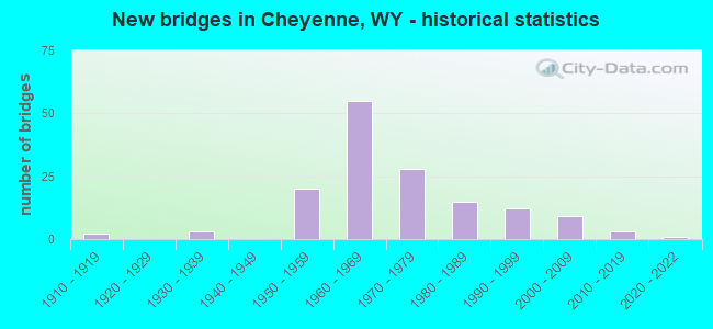
- New bridges - historical statistics
- 21910-1919
- 31930-1939
- 201950-1959
- 551960-1969
- 281970-1979
- 151980-1989
- 121990-1999
- 92000-2009
- 32010-2019
- 12020-2022
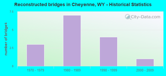
- Reconstructed bridges - Historical Statistics
- 31970-1979
- 71980-1989
- 41990-1999
- 12000-2009
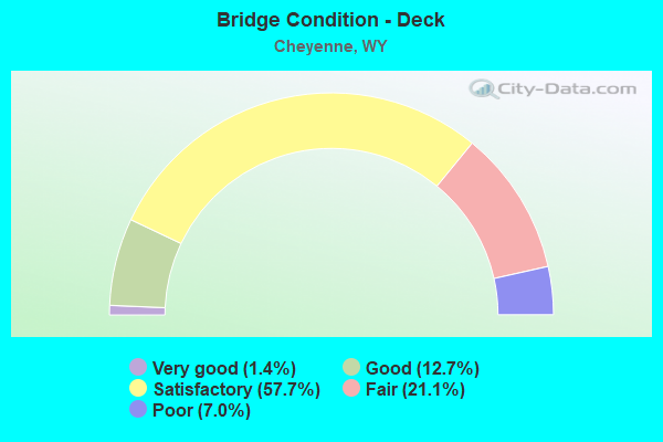
- Bridge Condition - Deck
- 1.4%Very good
- 12.7%Good
- 57.7%Satisfactory
- 21.1%Fair
- 7.0%Poor
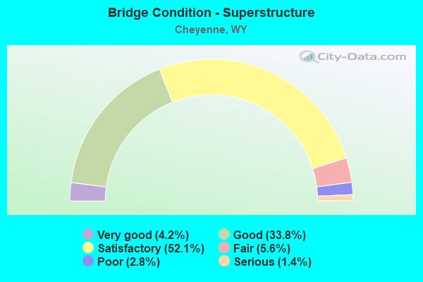
- Bridge Condition - Superstructure
- 4.2%Very good
- 33.8%Good
- 52.1%Satisfactory
- 5.6%Fair
- 2.8%Poor
- 1.4%Serious
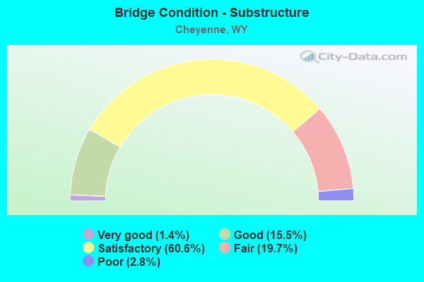
- Bridge Condition - Substructure
- 1.4%Very good
- 15.5%Good
- 60.6%Satisfactory
- 19.7%Fair
- 2.8%Poor
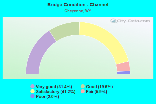
- Bridge Condition - Channel
- 31.4%Very good
- 19.6%Good
- 41.2%Satisfactory
- 5.9%Fair
- 2.0%Poor
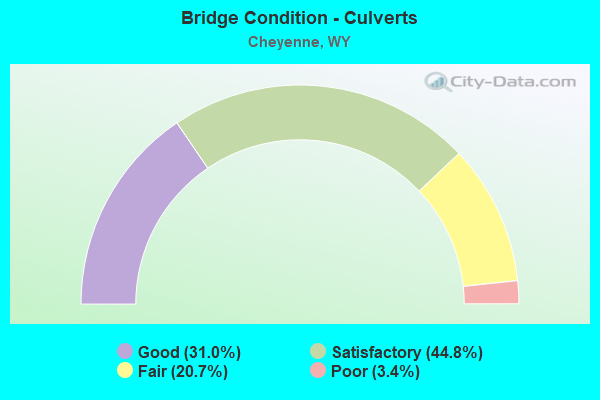
- Bridge Condition - Culverts
- 31.0%Good
- 44.8%Satisfactory
- 20.7%Fair
- 3.4%Poor
Find on map >> Show street view
Structure Number: JVS, Location: Converse Avenue (Lat: 41.160844, Lng: -104.785394), Route carried "on" structure: City street 4001, Year Built: 1992, Status: Open, Structure Length: 1.72m (5.64ft), Average Daily Traffic: 10,194 (year 2021), Truck Traffic: 9%, Average Future Daily Traffic: 14,272 (year 2041), Design Load: HS 20, Features Intersected: Dry Creek, Facility Carried by Structure: Converse Avenue
Minimum Vertical Clearance: 30+ m (98+ ft), Kilometerpoint: 164.992, Lanes on structure: 2, Owner: Town or Township Highway Agency, Approaching Roadway Width: 21.6m (70.9ft), Skew: 2 degrees, Material/Design: Concrete, Design/Construction: Culvert, Number Of Spans In Main Unit: 6, Length of Maximum Span: 3.0m (9.8ft), Curb or Sidewalk Widths: Left: 1.3m (4.3ft), Right: 2.8m (9.2ft), Curb-To-Curb Width: 19.2m (63.0ft), Out-to-Out Width: 26.7m (87.6ft)
Condition: Channel: Satisfactory, Culverts: Fair, Operating Rating: 78.4 metric tons, Method Used To Determine Operating Rating: Load Factor (LF), Inventory Rating: 47.0 metric tons, Method Used To Determine Inventory Rating: Load Factor (LF), Structural Evaluation: Somewhat better than minimum adequacy, Deck Geometry: Superior to present desirable criteria, Waterway Adequacy: Equal to present desirable criteria, Approach Roadway Alignment: Equal to present desirable criteria, Length Of Structure Improvement: 1.74m (5.71ft), Designated Inspection Frequency: Every 24 months, Inspection Date: December 2021, Bridge Improvement Cost: $6,000, Roadway Improvement Cost: $1,000, Total Project Cost: $10,000
Find on map >> Show street view
Structure Number: KCX, Location: Pershing Blvd (Lat: 41.145411, Lng: -104.745536), Route carried "on" structure: City street 210, Year Built: 1993, Status: Open, Structure Length: 2.05m (6.73ft), Average Daily Traffic: 363 (year 2021), Truck Traffic: 39%, Average Future Daily Traffic: 508 (year 2041), Design Load: HS 20, Features Intersected: Dry Creek
Minimum Vertical Clearance: 30+ m (98+ ft), Kilometerpoint: 7.825, Lanes on structure: 2, Owner: Town or Township Highway Agency, Approaching Roadway Width: 16.2m (53.1ft), Skew: 2 degrees, Material/Design: Concrete continuous, Design/Construction: Culvert, Number Of Spans In Main Unit: 5, Length of Maximum Span: 3.7m (12.1ft), Curb-To-Curb Width: 15.2m (49.9ft), Out-to-Out Width: 16.1m (52.8ft)
Condition: Channel: Very good, Culverts: Satisfactory, Operating Rating: 64.3 metric tons, Method Used To Determine Operating Rating: Load Factor (LF), Inventory Rating: 38.6 metric tons, Method Used To Determine Inventory Rating: Load Factor (LF), Structural Evaluation: Equal to present minimum criteria, Deck Geometry: Superior to present desirable criteria, Waterway Adequacy: Equal to present desirable criteria, Approach Roadway Alignment: Equal to present desirable criteria, Designated Inspection Frequency: Every 24 months, Inspection Date: December 2021
Find on map >> Show street view
Structure Number: KEF, Location: Colo St. Line-Cheyenne (Lat: 41.099467, Lng: -104.850081), Route carried "on" structure: Business US 212, Year Built: 1995, Status: Open, Structure Length: 6.71m (22.01ft), Average Daily Traffic: 13,762 (year 2021), Truck Traffic: 3%, Average Future Daily Traffic: 19,267 (year 2041), Design Load: HS 20, Features Intersected: I-25, Facility Carried by Structure: La Cnty Rd 926
Minimum Vertical Clearance: 30+ m (98+ ft), Kilometerpoint: 160.907, Lanes on structure: 2, Lanes under structure: 4, Base Highway Network: Yes, Owner: State Highway Agency, Approaching Roadway Width: 12.2m (40.0ft), Skew: 30 degrees, Material/Design: Steel continuous, Design/Construction: Stringer/Multi-beam, Number Of Spans In Main Unit: 3, Length of Maximum Span: 45.4m (149.0ft), Curb-To-Curb Width: 16.0m (52.5ft), Out-to-Out Width: 22.4m (73.5ft)
Condition: Deck: Satisfactory, Superstructure: Good, Substructure: Satisfactory, Operating Rating: 67.1 metric tons, Method Used To Determine Operating Rating: Load Factor (LF), Inventory Rating: 40.8 metric tons, Method Used To Determine Inventory Rating: Load Factor (LF), Structural Evaluation: Equal to present minimum criteria, Deck Geometry: Superior to present desirable criteria, Underclear: Equal to present minimum criteria, Approach Roadway Alignment: Equal to present desirable criteria, Designated Inspection Frequency: Every 24 months, Inspection Date: Febuary 2021, Deck Structure Type: Concrete Cast-file-Place, Wearing Surface/Protective System: Wearing Surface: Epoxy Overlay
Find on map >> Show street view
Structure Number: KPL, Location: Cheyenne Streets (Lat: 41.108886, Lng: -104.790033), Route carried "on" structure: City street 4019, Year Built: 1996, Status: Open, Structure Length: 1.14m (3.74ft), Average Daily Traffic: 3,628 (year 2021), Truck Traffic: 2%, Average Future Daily Traffic: 5,079 (year 2041), Design Load: HS 20, Features Intersected: Allison Draw, Facility Carried by Structure: La Cnty Rd 126-1
Minimum Vertical Clearance: 30+ m (98+ ft), Kilometerpoint: 4.699, Lanes on structure: 2, Owner: County Highway Agency, Approaching Roadway Width: 8.5m (27.9ft), Material/Design: Concrete, Design/Construction: Culvert, Number Of Spans In Main Unit: 3, Length of Maximum Span: 3.7m (12.1ft), Curb or Sidewalk Widths: Left: 2.2m (7.2ft), Right: 2.2m (7.2ft), Curb-To-Curb Width: 9.1m (29.9ft), Out-to-Out Width: 13.9m (45.6ft)
Condition: Channel: Very good, Culverts: Satisfactory, Operating Rating: 58.1 metric tons, Method Used To Determine Operating Rating: Load Factor (LF), Inventory Rating: 34.5 metric tons, Method Used To Determine Inventory Rating: Load Factor (LF), Structural Evaluation: Equal to present minimum criteria, Deck Geometry: Meets minimum limits, Waterway Adequacy: Equal to present desirable criteria, Approach Roadway Alignment: Equal to present desirable criteria, Length Of Structure Improvement: 5.76m (18.90ft), Designated Inspection Frequency: Every 24 months, Inspection Date: December 2021, Bridge Improvement Cost: $8,000, Roadway Improvement Cost: $30,000, Total Project Cost: $39,000
Find on map >> Show street view
Structure Number: KPX, Location: Cheyenne (Lat: 41.170197, Lng: -104.828603), Route carried "on" structure: City street 1108, Year Built: 1995, Status: Open, Structure Length: 0.61m (2.00ft), Average Daily Traffic: 5,428 (year 2021), Truck Traffic: 2%, Average Future Daily Traffic: 7,599 (year 2041), Design Load: HS 20, Features Intersected: Dry Creek, Facility Carried by Structure: WYO 219
Minimum Vertical Clearance: 30+ m (98+ ft), Kilometerpoint: 1.067, Lanes on structure: 5, Base Highway Network: Yes, Owner: Town or Township Highway Agency, Approaching Roadway Width: 27.1m (88.9ft), Material/Design: Concrete, Design/Construction: Culvert, Number Of Spans In Main Unit: 1, Length of Maximum Span: 6.1m (20.0ft), Curb or Sidewalk Widths: Left: 1.8m (5.9ft), Right: 4.0m (13.1ft), Curb-To-Curb Width: 27.2m (89.2ft), Out-to-Out Width: 39.4m (129.3ft)
Condition: Channel: Very good, Culverts: Satisfactory, Operating Rating: 32.7 metric tons, Method Used To Determine Operating Rating: Field evaluation and documented engineering judgment, Inventory Rating: 32.7 metric tons, Method Used To Determine Inventory Rating: Field evaluation and documented engineering judgment, Structural Evaluation: Equal to present minimum criteria, Deck Geometry: Superior to present desirable criteria, Waterway Adequacy: Equal to present desirable criteria, Approach Roadway Alignment: Equal to present desirable criteria, Designated Inspection Frequency: Every 24 months, Inspection Date: December 2021
Find on map >> Show street view
Structure Number: KSA, Location: Cheyenne (Lat: 41.102369, Lng: -104.807572), Route carried "on" structure: Alternate US 212, Year Built: 2001, Status: Open, Structure Length: 1.12m (3.67ft), Average Daily Traffic: 5,903 (year 2021), Truck Traffic: 7%, Average Future Daily Traffic: 8,264 (year 2041), Design Load: HS 25 or greater, Features Intersected: Allison Draw
Minimum Vertical Clearance: 30+ m (98+ ft), Kilometerpoint: 3.764, Lanes on structure: 2, Base Highway Network: Yes, Owner: State Highway Agency, Approaching Roadway Width: 14.3m (46.9ft), Material/Design: Concrete, Design/Construction: Culvert, Number Of Spans In Main Unit: 3, Length of Maximum Span: 3.6m (11.8ft)
Condition: Channel: Good, Culverts: Good, Operating Rating: 65.3 metric tons, Method Used To Determine Operating Rating: Load Factor (LF), Inventory Rating: 32.7 metric tons, Method Used To Determine Inventory Rating: Load Factor (LF), Structural Evaluation: Better than present minimum criteria, Waterway Adequacy: Equal to present desirable criteria, Approach Roadway Alignment: Equal to present desirable criteria, Designated Inspection Frequency: Every 24 months, Inspection Date: January 2022
Find on map >> Show street view
Structure Number: KSG, Location: Cheyenne Drainage (Lat: 41.108400, Lng: -104.770047), Route carried "on" structure: State highway 212, Year Built: 1997, Status: Open, Structure Length: 1.28m (4.20ft), Average Daily Traffic: 9,734 (year 2021), Truck Traffic: 4%, Average Future Daily Traffic: 13,628 (year 2041), Design Load: HS 20, Features Intersected: Allison Draw
Minimum Vertical Clearance: 30+ m (98+ ft), Kilometerpoint: 7.286, Lanes on structure: 3, Base Highway Network: Yes, Owner: State Highway Agency, Approaching Roadway Width: 12.8m (42.0ft), Material/Design: Concrete, Design/Construction: Culvert, Number Of Spans In Main Unit: 4, Length of Maximum Span: 3.0m (9.8ft)
Condition: Channel: Satisfactory, Culverts: Good, Operating Rating: 32.7 metric tons, Method Used To Determine Operating Rating: Field evaluation and documented engineering judgment, Inventory Rating: 32.7 metric tons, Method Used To Determine Inventory Rating: Field evaluation and documented engineering judgment, Structural Evaluation: Better than present minimum criteria, Waterway Adequacy: Equal to present desirable criteria, Approach Roadway Alignment: Equal to present desirable criteria, Designated Inspection Frequency: Every 24 months, Inspection Date: April 2021
Find on map >> Show street view
Structure Number: LEK, Location: Cheyenne (Lat: 41.105969, Lng: -104.803100), Route carried "on" structure: County highway 207A, Year Built: 2004, Status: Open, Structure Length: 1.57m (5.15ft), Average Daily Traffic: 1,599 (year 2021), Truck Traffic: 5%, Average Future Daily Traffic: 2,239 (year 2041), Design Load: HS 25 or greater, Features Intersected: Allison Draw, Facility Carried by Structure: La Cnty Rd 207-A
Minimum Vertical Clearance: 30+ m (98+ ft), Kilometerpoint: 1.252, Lanes on structure: 2, Owner: County Highway Agency, Approaching Roadway Width: 9.1m (29.9ft), Material/Design: Concrete, Design/Construction: Culvert, Number Of Spans In Main Unit: 4, Length of Maximum Span: 3.7m (12.1ft), Out-to-Out Width: 15.2m (49.9ft)
Condition: Channel: Very good, Culverts: Satisfactory, Operating Rating: 32.7 metric tons, Method Used To Determine Operating Rating: Field evaluation and documented engineering judgment, Inventory Rating: 32.7 metric tons, Method Used To Determine Inventory Rating: Field evaluation and documented engineering judgment, Structural Evaluation: Equal to present minimum criteria, Waterway Adequacy: Equal to present desirable criteria, Approach Roadway Alignment: Equal to present desirable criteria, Length Of Structure Improvement: 6.10m (20.01ft), Designated Inspection Frequency: Every 24 months, Inspection Date: December 2020, Bridge Improvement Cost: $1,000, Roadway Improvement Cost: $40,000, Total Project Cost: $42,000
Find on map >> Show street view
Structure Number: LEW, Location: Cheyenne (Lat: 41.121381, Lng: -104.803422), Route carried "on" structure: City street 4067, Year Built: 1999, Status: Open, Structure Length: 6.89m (22.60ft), Average Daily Traffic: 2,548 (year 2021), Truck Traffic: 20%, Average Future Daily Traffic: 3,567 (year 2041), Design Load: HS 20, Features Intersected: Crow Creek, Facility Carried by Structure: E. 1st Street
Minimum Vertical Clearance: 30+ m (98+ ft), Kilometerpoint: 161.156, Lanes on structure: 2, Owner: Town or Township Highway Agency, Approaching Roadway Width: 12.2m (40.0ft), Skew: 3 degrees, Material/Design: Prestressed concrete continuous, Design/Construction: Tee Beam, Number Of Spans In Main Unit: 4, Length of Maximum Span: 17.1m (56.1ft), Curb or Sidewalk Widths: Left: 2.8m (9.2ft), Right: 0.0m, Curb-To-Curb Width: 12.6m (41.3ft), Out-to-Out Width: 16.5m (54.1ft)
Condition: Deck: Good, Superstructure: Good, Substructure: Good, Channel: Satisfactory, Operating Rating: 54.4 metric tons, Method Used To Determine Operating Rating: Load Factor (LF), Inventory Rating: 32.7 metric tons, Method Used To Determine Inventory Rating: Load Factor (LF), Structural Evaluation: Better than present minimum criteria, Deck Geometry: Equal to present minimum criteria, Waterway Adequacy: Equal to present desirable criteria, Approach Roadway Alignment: Equal to present minimum criteria, Length Of Structure Improvement: 1.83m (6.00ft), Designated Inspection Frequency: Every 24 months, Inspection Date: December 2021, Bridge Improvement Cost: $2,000, Roadway Improvement Cost: $1,000, Total Project Cost: $4,000, Deck Structure Type: Concrete Precast Panels, Wearing Surface/Protective System: Wearing Surface: Monolithic Concrete
Find on map >> Show street view
Structure Number: LZL, Location: Cheyenne Streets (Lat: 41.122667, Lng: -104.794850), Route carried "on" structure: City street 4019, Year Built: 2006, Status: Open, Structure Length: 3.72m (12.20ft), Average Daily Traffic: 6,444 (year 2021), Truck Traffic: 8%, Average Future Daily Traffic: 9,022 (year 2041), Design Load: HS 20, Features Intersected: Crow Creek, Facility Carried by Structure: Morrie Avenue
Minimum Vertical Clearance: 30+ m (98+ ft), Kilometerpoint: 161.184, Lanes on structure: 2, Owner: Town or Township Highway Agency, Approaching Roadway Width: 12.8m (42.0ft), Material/Design: Prestressed concrete, Design/Construction: Tee Beam, Number Of Spans In Main Unit: 2, Length of Maximum Span: 18.3m (60.0ft), Curb or Sidewalk Widths: Left: 2.4m (7.9ft), Right: 0.0m, Curb-To-Curb Width: 13.0m (42.7ft), Out-to-Out Width: 16.5m (54.1ft)
Condition: Deck: Very good, Superstructure: Very good, Substructure: Satisfactory, Channel: Very good, Operating Rating: 59.0 metric tons, Method Used To Determine Operating Rating: Load Factor (LF), Inventory Rating: 31.8 metric tons, Method Used To Determine Inventory Rating: Load Factor (LF), Structural Evaluation: Equal to present minimum criteria, Deck Geometry: Somewhat better than minimum adequacy, Waterway Adequacy: Equal to present desirable criteria, Approach Roadway Alignment: Better than present minimum criteria, Designated Inspection Frequency: Every 24 months, Inspection Date: December 2021, Deck Structure Type: Concrete Precast Panels, Wearing Surface/Protective System: Wearing Surface: Bituminous
Find on map >> Show street view
Structure Number: MCJ, Location: Cheyenne Marginal (Lat: 41.145947, Lng: -104.838897), Route carried "on" structure: Interstate 25, Year Built: 2009, Status: Open, Structure Length: 7.32m (24.02ft), Average Daily Traffic: 10,976 (year 2021), Truck Traffic: 24%, Average Future Daily Traffic: 15,366 (year 2041), Design Load: HL 93, Features Intersected: Randall Avenue
Minimum Vertical Clearance: 30+ m (98+ ft), Kilometerpoint: 18.038, Lanes on structure: 2, Lanes under structure: 5, Base Highway Network: Yes, Owner: State Highway Agency, Approaching Roadway Width: 12.2m (40.0ft), Skew: 12 degrees, Material/Design: Steel continuous, Design/Construction: Stringer/Multi-beam, Number Of Spans In Main Unit: 3, Length of Maximum Span: 41.8m (137.1ft), Curb-To-Curb Width: 12.2m (40.0ft), Out-to-Out Width: 13.2m (43.3ft)
Condition: Deck: Good, Superstructure: Good, Substructure: Good, Operating Rating: 76.4 metric tons, Method Used To Determine Operating Rating: Load Factor (LF), Inventory Rating: 45.7 metric tons, Method Used To Determine Inventory Rating: Load Factor (LF), Structural Evaluation: Better than present minimum criteria, Deck Geometry: Better than present minimum criteria, Underclear: Superior to present desirable criteria, Approach Roadway Alignment: Equal to present desirable criteria, Designated Inspection Frequency: Every 24 months, Inspection Date: January 2022, Deck Structure Type: Concrete Cast-file-Place, Wearing Surface/Protective System: Wearing Surface: Epoxy Overlay, Deck Protection: Epoxy Coated Reinforcing
Find on map >> Show street view
Structure Number: MCK, Location: Cheyenne Marginal (Lat: 41.145989, Lng: -104.839058), Route carried "on" structure: Interstate 25, Year Built: 2009, Status: Open, Structure Length: 7.32m (24.02ft), Average Daily Traffic: 10,651 (year 2021), Truck Traffic: 20%, Average Future Daily Traffic: 14,911 (year 2041), Design Load: HL 93, Features Intersected: Randall Avenue
Minimum Vertical Clearance: 30+ m (98+ ft), Kilometerpoint: 18.044, Lanes on structure: 2, Lanes under structure: 5, Base Highway Network: Yes, Owner: State Highway Agency, Approaching Roadway Width: 12.2m (40.0ft), Skew: 12 degrees, Material/Design: Steel continuous, Design/Construction: Stringer/Multi-beam, Number Of Spans In Main Unit: 3, Length of Maximum Span: 41.8m (137.1ft), Curb-To-Curb Width: 12.2m (40.0ft), Out-to-Out Width: 13.2m (43.3ft)
Condition: Deck: Good, Superstructure: Good, Substructure: Good, Operating Rating: 71.7 metric tons, Method Used To Determine Operating Rating: Load Factor (LF), Inventory Rating: 42.6 metric tons, Method Used To Determine Inventory Rating: Load Factor (LF), Structural Evaluation: Better than present minimum criteria, Deck Geometry: Better than present minimum criteria, Underclear: Superior to present desirable criteria, Approach Roadway Alignment: Equal to present desirable criteria, Length Of Structure Improvement: 8.35m (27.40ft), Designated Inspection Frequency: Every 24 months, Inspection Date: January 2022, Bridge Improvement Cost: $1,187,000, Roadway Improvement Cost: $119,000, Total Project Cost: $1,780,000 ( Estimate for 2015), Deck Structure Type: Concrete Cast-file-Place, Wearing Surface/Protective System: Wearing Surface: Epoxy Overlay, Deck Protection: Epoxy Coated Reinforcing
Find on map >> Show street view
Structure Number: MCX, Location: Cheyenne Warren Avenue (Lat: 41.121747, Lng: -104.805378), Route carried "on" structure: City street 4069, Year Built: 2008, Status: Open, Structure Length: 3.14m (10.30ft), Average Daily Traffic: 668 (year 2021), Truck Traffic: 8%, Average Future Daily Traffic: 935 (year 2041), Design Load: HS 20, Features Intersected: Crow Creek, Facility Carried by Structure: Warren Avenue
Minimum Vertical Clearance: 30+ m (98+ ft), Kilometerpoint: 161.242, Lanes on structure: 2, Owner: Town or Township Highway Agency, Approaching Roadway Width: 11.9m (39.0ft), Skew: 2 degrees, Material/Design: Concrete, Design/Construction: Stringer/Multi-beam, Number Of Spans In Main Unit: 2, Length of Maximum Span: 15.2m (49.9ft), Curb or Sidewalk Widths: Left: 1.8m (5.9ft), Right: 1.8m (5.9ft), Curb-To-Curb Width: 9.8m (32.2ft), Out-to-Out Width: 14.6m (47.9ft)
Condition: Deck: Fair, Superstructure: Very good, Substructure: Good, Channel: Good, Operating Rating: 70.8 metric tons, Method Used To Determine Operating Rating: Load Factor (LF), Inventory Rating: 40.8 metric tons, Method Used To Determine Inventory Rating: Load Factor (LF), Structural Evaluation: Better than present minimum criteria, Deck Geometry: Equal to present minimum criteria, Waterway Adequacy: Equal to present desirable criteria, Approach Roadway Alignment: Equal to present desirable criteria, Designated Inspection Frequency: Every 24 months, Inspection Date: December 2020, Deck Structure Type: Concrete Cast-file-Place, Wearing Surface/Protective System: Wearing Surface: Integral Concrete
Find on map >> Show street view
Structure Number: MFT, Location: Colorado State Line - Che (Lat: 41.061494, Lng: -104.877047), Route carried "on" structure: Other road 9586, Year Built: 2010, Status: Open, Structure Length: 7.77m (25.49ft), Average Daily Traffic: 958 (year 2021), Truck Traffic: 28%, Average Future Daily Traffic: 1,341 (year 2041), Design Load: HS 20, Features Intersected: I-25, Facility Carried by Structure: La Cnty Rd 927
Minimum Vertical Clearance: 30+ m (98+ ft), Kilometerpoint: 0.214, Lanes on structure: 3, Lanes under structure: 4, Owner: State Highway Agency, Approaching Roadway Width: 14.0m (45.9ft), Material/Design: Steel continuous, Design/Construction: Stringer/Multi-beam, Number Of Spans In Main Unit: 3, Length of Maximum Span: 50.3m (165.0ft), Curb or Sidewalk Widths: Left: 0.0m, Right: 2.9m (9.5ft), Curb-To-Curb Width: 14.0m (45.9ft), Out-to-Out Width: 18.3m (60.0ft)
Condition: Deck: Good, Superstructure: Good, Substructure: Good, Inventory Rating: 67.1 metric tons, Method Used To Determine Inventory Rating: Load Factor (LF), Structural Evaluation: Better than present minimum criteria, Deck Geometry: Somewhat better than minimum adequacy, Underclear: Superior to present desirable criteria, Approach Roadway Alignment: Equal to present minimum criteria, Designated Inspection Frequency: Every 24 months, Inspection Date: January 2022, Deck Structure Type: Concrete Cast-file-Place, Wearing Surface/Protective System: Wearing Surface: Epoxy Overlay, Deck Protection: Epoxy Coated Reinforcing
Find on map >> Show street view
Structure Number: MGE, Location: Cheyenne Streets (Lat: 41.097961, Lng: -104.810539), Route carried "on" structure: Alternate County highway 769, Year Built: 2009, Status: Open, Structure Length: 0.80m (2.62ft), Average Daily Traffic: 460 (year 2021), Truck Traffic: 4%, Average Future Daily Traffic: 644 (year 2041), Features Intersected: Allison Draw
Minimum Vertical Clearance: 30+ m (98+ ft), Kilometerpoint: 0.491, Lanes on structure: 2, Owner: County Highway Agency, Approaching Roadway Width: 6.1m (20.0ft), Skew: 4 degrees, Material/Design: Steel, Design/Construction: Culvert, Number Of Spans In Main Unit: 1, Length of Maximum Span: 5.7m (18.7ft)
Condition: Channel: Very good, Culverts: Good, Operating Rating: 54.5 metric tons, Method Used To Determine Operating Rating: Field evaluation and documented engineering judgment, Inventory Rating: 32.7 metric tons, Method Used To Determine Inventory Rating: Field evaluation and documented engineering judgment, Structural Evaluation: Better than present minimum criteria, Waterway Adequacy: Equal to present desirable criteria, Approach Roadway Alignment: Equal to present desirable criteria, Designated Inspection Frequency: Every 24 months, Inspection Date: December 2021
Find on map >> Show street view
Structure Number: MGF, Location: Cheyenne (Lat: 41.097086, Lng: -104.811614), Route carried "on" structure: Alternate County highway 451, Year Built: 2009, Status: Open, Structure Length: 0.74m (2.43ft), Average Daily Traffic: 460 (year 2021), Truck Traffic: 4%, Average Future Daily Traffic: 644 (year 2041), Features Intersected: Allison Draw
Minimum Vertical Clearance: 30+ m (98+ ft), Kilometerpoint: 0.079, Lanes on structure: 2, Owner: County Highway Agency, Approaching Roadway Width: 6.1m (20.0ft), Skew: 4 degrees, Material/Design: Steel, Design/Construction: Culvert, Number Of Spans In Main Unit: 1, Length of Maximum Span: 5.7m (18.7ft)
Condition: Channel: Very good, Culverts: Good, Operating Rating: 32.7 metric tons, Method Used To Determine Operating Rating: Field evaluation and documented engineering judgment, Inventory Rating: 32.7 metric tons, Method Used To Determine Inventory Rating: Field evaluation and documented engineering judgment, Structural Evaluation: Better than present minimum criteria, Waterway Adequacy: Equal to present desirable criteria, Approach Roadway Alignment: Equal to present desirable criteria, Designated Inspection Frequency: Every 24 months, Inspection Date: December 2021
Find on map >> Show street view
Structure Number: MHF, Location: Cheyenne/Dunn Ave (Lat: 41.131950, Lng: -104.795242), Route carried "on" structure: City street 4019, Year Built: 2009, Status: Open, Structure Length: 8.80m (28.87ft), Average Daily Traffic: 12,941 (year 2021), Truck Traffic: 7%, Average Future Daily Traffic: 18,117 (year 2041), Design Load: HL 93, Features Intersected: UPRR, Facility Carried by Structure: Logan Avenue
Minimum Vertical Clearance: 30+ m (98+ ft), Kilometerpoint: 161.781, Lanes on structure: 4, Owner: Town or Township Highway Agency, Approaching Roadway Width: 9.1m (29.9ft), Material/Design: Steel continuous, Design/Construction: Box Beam or Girders - Multiple, Number Of Spans In Main Unit: 2, Length of Maximum Span: 45.4m (149.0ft), Curb or Sidewalk Widths: Left: 3.0m (9.8ft), Right: 1.8m (5.9ft), Curb-To-Curb Width: 17.1m (56.1ft), Out-to-Out Width: 23.4m (76.8ft)
Condition: Deck: Satisfactory, Superstructure: Satisfactory, Substructure: Satisfactory, Operating Rating: 83.5 metric tons, Method Used To Determine Operating Rating: Load Factor (LF), Inventory Rating: 64.4 metric tons, Method Used To Determine Inventory Rating: Load Factor (LF), Structural Evaluation: Equal to present minimum criteria, Deck Geometry: Somewhat better than minimum adequacy, Underclear: Somewhat better than minimum adequacy, Approach Roadway Alignment: Equal to present desirable criteria, Designated Inspection Frequency: Every 24 months, Inspection Date: December 2021, Deck Structure Type: Concrete Cast-file-Place, Wearing Surface/Protective System: Deck Protection: Epoxy Coated Reinforcing
Find on map >> Show street view
Structure Number: NCM, Location: East Edge of Cheyenne (Lat: 41.145775, Lng: -104.713342), Route carried "on" structure: City street CR103, Year Built: 2020, Status: Open, Structure Length: 8.23m (27.00ft), Average Daily Traffic: 8,933 (year 2021), Truck Traffic: 4%, Average Future Daily Traffic: 12,506 (year 2041), Design Load: HL 93, Features Intersected: UPRR, Facility Carried by Structure: Christensen Road
Minimum Vertical Clearance: 30+ m (98+ ft), Kilometerpoint: 161.535, Lanes on structure: 2, Base Highway Network: Yes, Owner: County Highway Agency, Approaching Roadway Width: 11.0m (36.1ft), Skew: 2 degrees, Material/Design: Steel continuous, Design/Construction: Stringer/Multi-beam, Number Of Spans In Main Unit: 3, Length of Maximum Span: 39.6m (129.9ft), Curb or Sidewalk Widths: Left: 2.9m (9.5ft), Right: 0.0m, Curb-To-Curb Width: 11.0m (36.1ft), Out-to-Out Width: 15.4m (50.5ft)
Condition: Deck: Good, Superstructure: Very good, Substructure: Very good, Operating Rating: 40.5 metric tons, Method Used To Determine Operating Rating: Load and Resistance Factor Rating (LRFR) rating reported by rating factor(RF) method using HL-93 loadings, Inventory Rating: 31.1 metric tons, Method Used To Determine Inventory Rating: Load and Resistance Factor Rating (LRFR) rating reported by rating factor(RF) method using HL-93 loadings, Structural Evaluation: Better than present minimum criteria, Deck Geometry: Meets minimum limits, Underclear: Superior to present desirable criteria, Approach Roadway Alignment: Equal to present desirable criteria, Designated Inspection Frequency: Every 24 months, Inspection Date: December 2020, Deck Structure Type: Concrete Cast-file-Place, Wearing Surface/Protective System: Deck Protection: Epoxy Coated Reinforcing
Find on map >> Show street view
Structure Number: AAG, Location: Colorado Line - Cheyenne (Lat: 41.035756, Lng: -104.896728), Route carried "under" structure: State highway 223, Year Built: 1964, Structure Length: 0. m, Average Daily Traffic: 1,044 (year 2021), Truck Traffic: 2%, Features Intersected: WYO 223 / Terry Ranch Rd, Facility Carried by Structure: I-25 NBL
Minimum Vertical Clearance: 5.32m (17.45ft), Kilometerpoint: 0.010, Lanes on structure: 2, Lanes under structure: 2, Material/Design: Concrete continuous, Design/Construction: Slab, Length of Maximum Span: 10.7m (35.1ft)
Find on map >> Show street view
Structure Number: AAH, Location: Colorado Line - Cheyenne (Lat: 41.035817, Lng: -104.896950), Route carried "under" structure: County highway , Year Built: 1964, Structure Length: 0. m, Average Daily Traffic: 1,044 (year 2021), Truck Traffic: 2%, Features Intersected: WYO 223 / Terry Ranch Rd, Facility Carried by Structure: I-25 SBL
Minimum Vertical Clearance: 5.27m (17.29ft), Kilometerpoint: 0.011, Lanes on structure: 2, Lanes under structure: 2, Material/Design: Concrete continuous, Design/Construction: Slab, Length of Maximum Span: 10.7m (35.1ft)
Find on map >> Show street view
Structure Number: AAR, Location: Colorado Line - Cheyenne (Lat: 41.113631, Lng: -104.850722), Route carried "under" structure: Ramp Interstate 80, Year Built: 1963, Structure Length: 0. m, Average Daily Traffic: 907 (year 2021), Truck Traffic: 10%, Features Intersected: I-80, Facility Carried by Structure: I-25 NBL
Minimum Vertical Clearance: 5.66m (18.57ft), Kilometerpoint: 0.472, Lanes on structure: 3, Lanes under structure: 1, Material/Design: Steel continuous, Design/Construction: Stringer/Multi-beam, Length of Maximum Span: 25.6m (84.0ft)
Find on map >> Show street view
Structure Number: AAR, Location: Colorado Line - Cheyenne (Lat: 41.113631, Lng: -104.850722), Route carried "under" structure: Interstate 80, Year Built: 1963, Structure Length: 0. m, Average Daily Traffic: 9,900 (year 2021), Truck Traffic: 57%, Features Intersected: I-80, Facility Carried by Structure: I-25 NBL
Minimum Vertical Clearance: 5.66m (18.57ft), Kilometerpoint: 578.372, Lanes on structure: 3, Lanes under structure: 2, Material/Design: Steel continuous, Design/Construction: Stringer/Multi-beam, Length of Maximum Span: 25.6m (84.0ft)
Find on map >> Show street view
Structure Number: AAR, Location: Colorado Line - Cheyenne (Lat: 41.113631, Lng: -104.850722), Route carried "under" structure: Interstate 80, Year Built: 1963, Structure Length: 0. m, Average Daily Traffic: 10,825 (year 2021), Truck Traffic: 44%, Features Intersected: I-80, Facility Carried by Structure: I-25 NBL
Minimum Vertical Clearance: 5.74m (18.83ft), Kilometerpoint: 578.094, Lanes on structure: 3, Lanes under structure: 2, Material/Design: Steel continuous, Design/Construction: Stringer/Multi-beam, Length of Maximum Span: 25.6m (84.0ft)
Find on map >> Show street view
Structure Number: AAR, Location: Colorado Line - Cheyenne (Lat: 41.113631, Lng: -104.850722), Route carried "under" structure: Ramp Interstate 80, Year Built: 1963, Structure Length: 0. m, Average Daily Traffic: 2,410 (year 2021), Truck Traffic: 61%, Features Intersected: I-80, Facility Carried by Structure: I-25 NBL
Minimum Vertical Clearance: 5.74m (18.83ft), Kilometerpoint: 0.000, Lanes on structure: 3, Lanes under structure: 1, Material/Design: Steel continuous, Design/Construction: Stringer/Multi-beam, Length of Maximum Span: 25.6m (84.0ft)
Find on map >> Show street view
Structure Number: AAS, Location: Colorado Line - Cheyenne (Lat: 41.113569, Lng: -104.850992), Route carried "under" structure: Interstate 80, Year Built: 1963, Structure Length: 0. m, Average Daily Traffic: 9,900 (year 2021), Truck Traffic: 57%, Features Intersected: I-80, Facility Carried by Structure: I-25 SBL
Minimum Vertical Clearance: 5.16m (16.93ft), Kilometerpoint: 578.348, Lanes on structure: 3, Lanes under structure: 2, Material/Design: Steel continuous, Design/Construction: Stringer/Multi-beam, Length of Maximum Span: 25.6m (84.0ft)
Find on map >> Show street view
Structure Number: AAS, Location: Colorado Line - Cheyenne (Lat: 41.113569, Lng: -104.850992), Route carried "under" structure: Interstate 80, Year Built: 1963, Structure Length: 0. m, Average Daily Traffic: 10,825 (year 2021), Truck Traffic: 44%, Features Intersected: I-80, Facility Carried by Structure: I-25 SBL
Minimum Vertical Clearance: 5.66m (18.57ft), Kilometerpoint: 578.072, Lanes on structure: 3, Lanes under structure: 2, Material/Design: Steel continuous, Design/Construction: Stringer/Multi-beam, Length of Maximum Span: 25.6m (84.0ft)
Find on map >> Show street view
Structure Number: AAS, Location: Colorado Line - Cheyenne (Lat: 41.113569, Lng: -104.850992), Route carried "under" structure: Ramp Interstate 80, Year Built: 1963, Structure Length: 0. m, Average Daily Traffic: 2,424 (year 2021), Truck Traffic: 19%, Features Intersected: I-80, Facility Carried by Structure: I-25 SBL
Minimum Vertical Clearance: 5.16m (16.93ft), Kilometerpoint: 0.042, Lanes on structure: 3, Lanes under structure: 1, Material/Design: Steel continuous, Design/Construction: Stringer/Multi-beam, Length of Maximum Span: 25.6m (84.0ft)
Find on map >> Show street view
Structure Number: AAS, Location: Colorado Line - Cheyenne (Lat: 41.113569, Lng: -104.850992), Route carried "under" structure: Ramp Interstate 80, Year Built: 1963, Structure Length: 0. m, Average Daily Traffic: 3,379 (year 2021), Truck Traffic: 23%, Features Intersected: I-80, Facility Carried by Structure: I-25 SBL
Minimum Vertical Clearance: 5.66m (18.57ft), Kilometerpoint: 0.037, Lanes on structure: 3, Lanes under structure: 1, Material/Design: Steel continuous, Design/Construction: Stringer/Multi-beam, Length of Maximum Span: 25.6m (84.0ft)
Find on map >> Show street view
Structure Number: AAV, Location: Cheyenne (Lat: 41.117725, Lng: -104.850828), Route carried "under" structure: Business US 30, Year Built: 1963, Structure Length: 0. m, Average Daily Traffic: 3,779 (year 2021), Truck Traffic: 9%, Features Intersected: UPRR / US 30, Facility Carried by Structure: I-25 NBL
Minimum Vertical Clearance: 7.96m (26.12ft), Kilometerpoint: 579.457, Lanes on structure: 3, Lanes under structure: 4, Material/Design: Steel continuous, Design/Construction: Stringer/Multi-beam, Length of Maximum Span: 34.4m (112.9ft)
Find on map >> Show street view
Structure Number: AAW, Location: Cheyenne (Lat: 41.117606, Lng: -104.851097), Route carried "under" structure: Business US 30, Year Built: 1963, Structure Length: 0. m, Average Daily Traffic: 3,077 (year 2021), Truck Traffic: 13%, Features Intersected: UPRR / US 30, Facility Carried by Structure: I-25 SBL
Minimum Vertical Clearance: 7.93m (26.02ft), Kilometerpoint: 579.433, Lanes on structure: 3, Lanes under structure: 4, Material/Design: Steel continuous, Design/Construction: Stringer/Multi-beam, Length of Maximum Span: 34.4m (112.9ft)
Find on map >> Show street view
Structure Number: ABB, Location: Cheyenne (Lat: 41.136586, Lng: -104.840511), Route carried "under" structure: City street 9013, Year Built: 1958, Structure Length: 0. m, Average Daily Traffic: 576 (year 2021), Truck Traffic: 3%, Features Intersected: Missile Dr/Happy Jack Rd, Facility Carried by Structure: I-25 NBL
Minimum Vertical Clearance: 5.19m (17.03ft), Kilometerpoint: 0.328, Lanes on structure: 2, Lanes under structure: 4, Material/Design: Concrete continuous, Design/Construction: Frame, Length of Maximum Span: 16.3m (53.5ft)
Find on map >> Show street view
Structure Number: ABK, Location: Cheyenne (Lat: 41.159531, Lng: -104.839361), Route carried "under" structure: Interstate 25, Year Built: 1957, Structure Length: 0. m, Average Daily Traffic: 7,152 (year 2021), Truck Traffic: 16%, Features Intersected: I-25, Facility Carried by Structure: Stinner Road
Minimum Vertical Clearance: 5.52m (18.11ft), Kilometerpoint: 19.549, Lanes on structure: 2, Lanes under structure: 2, Material/Design: Concrete continuous, Design/Construction: Tee Beam, Length of Maximum Span: 18.3m (60.0ft)
Find on map >> Show street view
Structure Number: ABK, Location: Cheyenne (Lat: 41.159531, Lng: -104.839361), Route carried "under" structure: Interstate 25, Year Built: 1957, Structure Length: 0. m, Average Daily Traffic: 9,233 (year 2021), Truck Traffic: 44%, Features Intersected: I-25, Facility Carried by Structure: Stinner Road
Minimum Vertical Clearance: 5.50m (18.04ft), Kilometerpoint: 19.549, Lanes on structure: 2, Lanes under structure: 2, Material/Design: Concrete continuous, Design/Construction: Tee Beam, Length of Maximum Span: 18.3m (60.0ft)
Find on map >> Show street view
Structure Number: ABP, Location: Vandehei Ave Cheyenne (Lat: 41.183661, Lng: -104.838461), Route carried "under" structure: Interstate 25, Year Built: 1963, Structure Length: 0. m, Average Daily Traffic: 5,651 (year 2021), Truck Traffic: 44%, Features Intersected: I-25, Facility Carried by Structure: Vandehei Avenue
Minimum Vertical Clearance: 5.13m (16.83ft), Kilometerpoint: 22.248, Lanes on structure: 2, Lanes under structure: 2, Material/Design: Steel continuous, Design/Construction: Stringer/Multi-beam, Length of Maximum Span: 17.1m (56.1ft)
Find on map >> Show street view
Structure Number: ABP, Location: Vandehei Ave Cheyenne (Lat: 41.183661, Lng: -104.838461), Route carried "under" structure: Interstate 25, Year Built: 1963, Structure Length: 0. m, Average Daily Traffic: 6,193 (year 2021), Truck Traffic: 20%, Features Intersected: I-25, Facility Carried by Structure: Vandehei Avenue
Minimum Vertical Clearance: 5.16m (16.93ft), Kilometerpoint: 22.248, Lanes on structure: 2, Lanes under structure: 2, Material/Design: Steel continuous, Design/Construction: Stringer/Multi-beam, Length of Maximum Span: 17.1m (56.1ft)
Find on map >> Show street view
Structure Number: ADR, Location: Cheyenne (Lat: 41.120544, Lng: -104.793664), Route carried "under" structure: Business City street , Year Built: 1973, Structure Length: 0. m, Average Daily Traffic: 457 (year 2021), Truck Traffic: 13%, Features Intersected: Morrie Avenue, Facility Carried by Structure: I-80 EBL
Minimum Vertical Clearance: 4.98m (16.34ft), Kilometerpoint: 160.930, Lanes on structure: 2, Lanes under structure: 2, Material/Design: Steel continuous, Design/Construction: Frame, Length of Maximum Span: 19.2m (63.0ft)
Find on map >> Show street view
Structure Number: AYU, Location: Laramie - Cheyenne (Lat: 41.114772, Lng: -104.860861), Route carried "under" structure: Business US 56, Year Built: 1963, Structure Length: 0. m, Average Daily Traffic: 3,779 (year 2021), Truck Traffic: 9%, Features Intersected: UPRR / US 30, Facility Carried by Structure: I-80 EBL
Minimum Vertical Clearance: 8.84m (29.00ft), Kilometerpoint: 578.562, Lanes on structure: 2, Lanes under structure: 4, Material/Design: Steel continuous, Design/Construction: Stringer/Multi-beam, Length of Maximum Span: 20.7m (67.9ft)
Find on map >> Show street view
Structure Number: AYV, Location: Laramie - Cheyenne (Lat: 41.114872, Lng: -104.860597), Route carried "under" structure: Business US 56, Year Built: 1963, Structure Length: 0. m, Average Daily Traffic: 3,779 (year 2021), Truck Traffic: 9%, Features Intersected: UPRR / US 30, Facility Carried by Structure: I-80 WBL
Minimum Vertical Clearance: 9.08m (29.79ft), Kilometerpoint: 578.587, Lanes on structure: 3, Lanes under structure: 4, Material/Design: Steel continuous, Design/Construction: Stringer/Multi-beam, Length of Maximum Span: 20.7m (67.9ft)
Find on map >> Show street view
Structure Number: AYZ, Location: Cheyenne (Lat: 41.115300, Lng: -104.843844), Route carried "under" structure: City street 4016, Year Built: 1965, Structure Length: 0. m, Average Daily Traffic: 1,355 (year 2021), Truck Traffic: 22%, Features Intersected: La CR 123-1/Southwest Dr, Facility Carried by Structure: I-80 EBL
Minimum Vertical Clearance: 4.55m (14.93ft), Kilometerpoint: 1.811, Lanes on structure: 2, Lanes under structure: 2, Material/Design: Steel continuous, Design/Construction: Stringer/Multi-beam, Length of Maximum Span: 14.0m (45.9ft)
Find on map >> Show street view
Structure Number: AZA, Location: Cheyenne (Lat: 41.115506, Lng: -104.843833), Route carried "under" structure: City street 4016, Year Built: 1965, Structure Length: 0. m, Average Daily Traffic: 1,355 (year 2021), Truck Traffic: 22%, Features Intersected: La CR 123-1/Southwest Dr, Facility Carried by Structure: I-80 WBL
Minimum Vertical Clearance: 4.55m (14.93ft), Kilometerpoint: 1.833, Lanes on structure: 2, Lanes under structure: 2, Material/Design: Steel continuous, Design/Construction: Stringer/Multi-beam, Length of Maximum Span: 14.0m (45.9ft)
Find on map >> Show street view
Structure Number: AZC, Location: Cheyenne (Lat: 41.116344, Lng: -104.836303), Route carried "under" structure: Interstate 80, Year Built: 1965, Structure Length: 0. m, Average Daily Traffic: 9,900 (year 2021), Truck Traffic: 55%, Features Intersected: I-80, Facility Carried by Structure: BNSF Railway
Minimum Vertical Clearance: 5.11m (16.77ft), Kilometerpoint: 579.623, Lanes under structure: 2, Material/Design: Steel, Design/Construction: Stringer/Multi-beam, Length of Maximum Span: 17.7m (58.1ft)
Find on map >> Show street view
Structure Number: AZC, Location: Cheyenne (Lat: 41.116344, Lng: -104.836303), Route carried "under" structure: Interstate 80, Year Built: 1965, Structure Length: 0. m, Average Daily Traffic: 10,825 (year 2021), Truck Traffic: 44%, Features Intersected: I-80, Facility Carried by Structure: BNSF Railway
Minimum Vertical Clearance: 4.93m (16.17ft), Kilometerpoint: 579.353, Lanes under structure: 2, Material/Design: Steel, Design/Construction: Stringer/Multi-beam, Length of Maximum Span: 17.7m (58.1ft)
Find on map >> Show street view
Structure Number: AZD, Location: Parsley Blvd-Cheyenne (Lat: 41.116061, Lng: -104.828789), Route carried "under" structure: Interstate 80, Year Built: 1965, Structure Length: 0. m, Average Daily Traffic: 10,825 (year 2021), Truck Traffic: 44%, Features Intersected: I-80, Facility Carried by Structure: La Cnty Rd 124-1
Minimum Vertical Clearance: 5.03m (16.50ft), Kilometerpoint: 579.985, Lanes on structure: 2, Lanes under structure: 2, Material/Design: Steel continuous, Design/Construction: Stringer/Multi-beam, Length of Maximum Span: 18.0m (59.1ft)
Find on map >> Show street view
Structure Number: AZD, Location: Parsley Blvd-Cheyenne (Lat: 41.116061, Lng: -104.828789), Route carried "under" structure: Interstate 80, Year Built: 1965, Structure Length: 0. m, Average Daily Traffic: 9,900 (year 2021), Truck Traffic: 55%, Features Intersected: I-80, Facility Carried by Structure: La Cnty Rd 124-1
Minimum Vertical Clearance: 5.16m (16.93ft), Kilometerpoint: 580.255, Lanes on structure: 2, Lanes under structure: 2, Material/Design: Steel continuous, Design/Construction: Stringer/Multi-beam, Length of Maximum Span: 18.0m (59.1ft)
Find on map >> Show street view
Structure Number: AZI, Location: Cheyenne (Lat: 41.118856, Lng: -104.805242), Route carried "under" structure: Business US 85, Year Built: 1966, Structure Length: 0. m, Average Daily Traffic: 10,097 (year 2021), Truck Traffic: 5%, Features Intersected: South Greeley Highway, Facility Carried by Structure: I-80 EBL
Minimum Vertical Clearance: 5.56m (18.24ft), Kilometerpoint: 13.655, Lanes on structure: 2, Lanes under structure: 2, Material/Design: Steel continuous, Design/Construction: Stringer/Multi-beam, Length of Maximum Span: 29.3m (96.1ft)
Find on map >> Show street view
Structure Number: AZI, Location: Cheyenne (Lat: 41.118856, Lng: -104.805242), Route carried "under" structure: Business US 85, Year Built: 1966, Structure Length: 0. m, Average Daily Traffic: 11,025 (year 2021), Truck Traffic: 3%, Features Intersected: South Greeley Highway, Facility Carried by Structure: I-80 EBL
Minimum Vertical Clearance: 5.23m (17.16ft), Kilometerpoint: 13.676, Lanes on structure: 2, Lanes under structure: 2, Material/Design: Steel continuous, Design/Construction: Stringer/Multi-beam, Length of Maximum Span: 29.3m (96.1ft)
Find on map >> Show street view
Structure Number: AZJ, Location: Cheyenne (Lat: 41.119019, Lng: -104.805353), Route carried "under" structure: Business US 85, Year Built: 1966, Structure Length: 0. m, Average Daily Traffic: 11,025 (year 2021), Truck Traffic: 3%, Features Intersected: South Greeley Highway, Facility Carried by Structure: I-80 WBL
Minimum Vertical Clearance: 6.65m (21.82ft), Kilometerpoint: 13.697, Lanes on structure: 2, Lanes under structure: 2, Material/Design: Steel continuous, Design/Construction: Stringer/Multi-beam, Length of Maximum Span: 29.3m (96.1ft)
Find on map >> Show street view
Structure Number: AZJ, Location: Cheyenne (Lat: 41.119019, Lng: -104.805353), Route carried "under" structure: Business US 85, Year Built: 1966, Structure Length: 0. m, Average Daily Traffic: 10,097 (year 2021), Truck Traffic: 5%, Features Intersected: South Greeley Highway, Facility Carried by Structure: I-80 WBL
Minimum Vertical Clearance: 6.65m (21.82ft), Kilometerpoint: 13.687, Lanes on structure: 2, Lanes under structure: 2, Material/Design: Steel continuous, Design/Construction: Stringer/Multi-beam, Length of Maximum Span: 29.3m (96.1ft)
Find on map >> Show street view
Structure Number: BLF, Location: Missile Drive Cheyenne (Lat: 41.132942, Lng: -104.833161), Route carried "under" structure: State highway 226, Year Built: 1959, Structure Length: 0. m, Average Daily Traffic: 3,781 (year 2021), Truck Traffic: 8%, Features Intersected: Missile Drive, Facility Carried by Structure: BNSF Railway
Minimum Vertical Clearance: 4.90m (16.08ft), Kilometerpoint: 162.986, Lanes under structure: 4, Material/Design: Steel, Design/Construction: Stringer/Multi-beam, Length of Maximum Span: 9.8m (32.2ft)
Find on map >> Show street view
Structure Number: CGC, Location: Cheyenne - Pine Bluffs (Lat: 41.157456, Lng: -104.655758), Route carried "under" structure: Interstate 80, Year Built: 1976, Structure Length: 0. m, Average Daily Traffic: 6,500 (year 2021), Truck Traffic: 44%, Features Intersected: I-80, Facility Carried by Structure: US 30
Minimum Vertical Clearance: 5.82m (19.09ft), Kilometerpoint: 595.551, Lanes on structure: 2, Lanes under structure: 2, Material/Design: Concrete continuous, Design/Construction: Box Beam or Girders - Multiple, Length of Maximum Span: 48.8m (160.1ft)
Find on map >> Show street view
Structure Number: CGC, Location: Cheyenne - Pine Bluffs (Lat: 41.157456, Lng: -104.655758), Route carried "under" structure: Interstate 80, Year Built: 1976, Structure Length: 0. m, Average Daily Traffic: 7,169 (year 2021), Truck Traffic: 78%, Features Intersected: I-80, Facility Carried by Structure: US 30
Minimum Vertical Clearance: 5.43m (17.81ft), Kilometerpoint: 595.829, Lanes on structure: 2, Lanes under structure: 2, Material/Design: Concrete continuous, Design/Construction: Box Beam or Girders - Multiple, Length of Maximum Span: 48.8m (160.1ft)
Find on map >> Show street view
Structure Number: CIX, Location: Happy Jack Rd - Cheyenne (Lat: 41.131431, Lng: -104.834692), Route carried "under" structure: Alternate City street 506, Year Built: 1911, Structure Length: 0. m, Average Daily Traffic: 1,362 (year 2021), Truck Traffic: 5%, Features Intersected: Old Happy Jack Road, Facility Carried by Structure: BNSF Railway
Minimum Vertical Clearance: 0.37m (1.21ft), Kilometerpoint: 159.262, Lanes under structure: 2, Material/Design: Concrete, Design/Construction: Arch - Deck, Length of Maximum Span: 21.0m (68.9ft)
Find on map >> Show street view
Structure Number: CMO, Location: Cheyenne (Lat: 41.123839, Lng: -104.837778), Route carried "under" structure: Business US 30, Year Built: 1911, Structure Length: 0. m, Average Daily Traffic: 4,830 (year 2021), Truck Traffic: 5%, Features Intersected: US 30 / UPRR, Facility Carried by Structure: BNSF Railway
Minimum Vertical Clearance: 4.58m (15.03ft), Kilometerpoint: 580.753, Lanes under structure: 4, Material/Design: Steel, Design/Construction: Truss - Thru, Length of Maximum Span: 38.4m (126.0ft)
Find on map >> Show street view
Structure Number: DBR, Location: Cheyenne - Pine Bluffs (Lat: 41.134922, Lng: -104.704494), Route carried "under" structure: City street 207, Year Built: 1977, Structure Length: 0. m, Average Daily Traffic: 1,884 (year 2021), Truck Traffic: 17%, Features Intersected: Campstool Road, Facility Carried by Structure: I-80 EBL
Minimum Vertical Clearance: 5.18m (16.99ft), Kilometerpoint: 8.103, Lanes on structure: 2, Lanes under structure: 3, Material/Design: Steel continuous, Design/Construction: Frame, Length of Maximum Span: 17.1m (56.1ft)
Find on map >> Show street view
Structure Number: DBS, Location: Cheyenne - Pine Bluffs (Lat: 41.135269, Lng: -104.704819), Route carried "under" structure: City street 209, Year Built: 1977, Structure Length: 0. m, Average Daily Traffic: 1,884 (year 2021), Truck Traffic: 17%, Features Intersected: Campstool Road, Facility Carried by Structure: I-80 WBL
Minimum Vertical Clearance: 5.18m (16.99ft), Kilometerpoint: 8.079, Lanes on structure: 2, Lanes under structure: 3, Material/Design: Steel continuous, Design/Construction: Frame, Length of Maximum Span: 17.1m (56.1ft)
Find on map >> Show street view
Structure Number: DBW, Location: College Drive Cheyenne (Lat: 41.123758, Lng: -104.766953), Route carried "under" structure: Interstate 80, Year Built: 1977, Structure Length: 0. m, Average Daily Traffic: 9,900 (year 2021), Truck Traffic: 57%, Features Intersected: I-80, Facility Carried by Structure: WYO 212
Minimum Vertical Clearance: 5.21m (17.09ft), Kilometerpoint: 585.529, Lanes on structure: 5, Lanes under structure: 2, Material/Design: Steel continuous, Design/Construction: Box Beam or Girders - Multiple, Length of Maximum Span: 35.1m (115.2ft)
Find on map >> Show street view
Structure Number: DBW, Location: College Drive Cheyenne (Lat: 41.123758, Lng: -104.766953), Route carried "under" structure: Interstate 80, Year Built: 1977, Structure Length: 0. m, Average Daily Traffic: 9,233 (year 2021), Truck Traffic: 44%, Features Intersected: I-80, Facility Carried by Structure: WYO 212
Minimum Vertical Clearance: 5.16m (16.93ft), Kilometerpoint: 585.259, Lanes on structure: 5, Lanes under structure: 2, Material/Design: Steel continuous, Design/Construction: Box Beam or Girders - Multiple, Length of Maximum Span: 35.1m (115.2ft)
Find on map >> Show street view
Structure Number: DBX, Location: College Drive Cheyenne (Lat: 41.128111, Lng: -104.766550), Route carried "under" structure: City street 209-3, Year Built: 1977, Structure Length: 0. m, Average Daily Traffic: 2,417 (year 2021), Truck Traffic: 4%, Features Intersected: UPRR / Campstool Rd, Facility Carried by Structure: WYO 212
Minimum Vertical Clearance: 8.65m (28.38ft), Kilometerpoint: 2.565, Lanes on structure: 5, Lanes under structure: 2, Material/Design: Steel continuous, Design/Construction: Stringer/Multi-beam, Length of Maximum Span: 40.8m (133.9ft)
Find on map >> Show street view
Structure Number: DPQ, Location: T13N R066W S06 (Lat: 41.127664, Lng: -104.824142), Route carried "under" structure: City street 50-2, Year Built: 1950, Structure Length: 0. m, Average Daily Traffic: 8,122 (year 2021), Truck Traffic: 4%, Features Intersected: Dey Ave, Facility Carried by Structure: UPRR
Minimum Vertical Clearance: 3.98m (13.06ft), Kilometerpoint: 162.510, Lanes under structure: 2, Material/Design: Steel continuous, Design/Construction: Stringer/Multi-beam, Length of Maximum Span: 20.7m (67.9ft)
Find on map >> Show street view
Structure Number: DPR, Location: T13N R066W S06 (Lat: 41.126086, Lng: -104.823053), Route carried "under" structure: City street 5002, Year Built: 1950, Structure Length: 0. m, Average Daily Traffic: 8,122 (year 2021), Truck Traffic: 4%, Features Intersected: Dey Ave, Facility Carried by Structure: UPRR
Minimum Vertical Clearance: 4.58m (15.03ft), Kilometerpoint: 162.312, Lanes under structure: 2, Material/Design: Steel continuous, Design/Construction: Stringer/Multi-beam, Length of Maximum Span: 14.0m (45.9ft)
Find on map >> Show street view
Structure Number: EOI, Location: Cheyenne (Lat: 41.167158, Lng: -104.839708), Route carried "under" structure: Interstate 25, Year Built: 1984, Structure Length: 0. m, Average Daily Traffic: 7,119 (year 2021), Truck Traffic: 19%, Features Intersected: I-25, Facility Carried by Structure: Central Ave
Minimum Vertical Clearance: 5.37m (17.62ft), Kilometerpoint: 20.408, Lanes on structure: 5, Lanes under structure: 2, Material/Design: Steel continuous, Design/Construction: Stringer/Multi-beam, Length of Maximum Span: 44.2m (145.0ft)
Find on map >> Show street view
Structure Number: EOI, Location: Cheyenne (Lat: 41.167158, Lng: -104.839708), Route carried "under" structure: Interstate _, Year Built: 1984, Structure Length: 0. m, Average Daily Traffic: 7,227 (year 2021), Truck Traffic: 20%, Features Intersected: I-25, Facility Carried by Structure: Central Ave
Minimum Vertical Clearance: 5.12m (16.80ft), Kilometerpoint: 20.411, Lanes on structure: 5, Lanes under structure: 2, Material/Design: Steel continuous, Design/Construction: Stringer/Multi-beam, Length of Maximum Span: 44.2m (145.0ft)
Find on map >> Show street view
Structure Number: KEF, Location: Colo St. Line-Cheyenne (Lat: 41.099467, Lng: -104.850081), Route carried "under" structure: Interstate 25, Year Built: 1995, Structure Length: 0. m, Average Daily Traffic: 10,584 (year 2021), Truck Traffic: 26%, Features Intersected: I-25, Facility Carried by Structure: La Cnty Rd 926
Minimum Vertical Clearance: 5.19m (17.03ft), Kilometerpoint: 12.629, Lanes on structure: 2, Lanes under structure: 2, Material/Design: Steel continuous, Design/Construction: Stringer/Multi-beam, Length of Maximum Span: 45.4m (149.0ft)
Find on map >> Show street view
Structure Number: KEF, Location: Colo St. Line-Cheyenne (Lat: 41.099467, Lng: -104.850081), Route carried "under" structure: Interstate 25, Year Built: 1995, Structure Length: 0. m, Average Daily Traffic: 10,651 (year 2021), Truck Traffic: 20%, Features Intersected: I-25, Facility Carried by Structure: La Cnty Rd 926
Minimum Vertical Clearance: 5.37m (17.62ft), Kilometerpoint: 12.627, Lanes on structure: 2, Lanes under structure: 2, Material/Design: Steel continuous, Design/Construction: Stringer/Multi-beam, Length of Maximum Span: 45.4m (149.0ft)
Find on map >> Show street view
Structure Number: MFT, Location: Colorado State Line - Che (Lat: 41.061494, Lng: -104.877047), Route carried "under" structure: Interstate 25, Year Built: 2010, Structure Length: 0. m, Average Daily Traffic: 10,584 (year 2021), Truck Traffic: 26%, Features Intersected: I-25, Facility Carried by Structure: La Cnty Rd 927
Minimum Vertical Clearance: 6.04m (19.82ft), Kilometerpoint: 7.619, Lanes on structure: 3, Lanes under structure: 2, Material/Design: Steel continuous, Design/Construction: Stringer/Multi-beam, Length of Maximum Span: 50.3m (165.0ft)
Find on map >> Show street view
Structure Number: MFT, Location: Colorado State Line - Che (Lat: 41.061494, Lng: -104.877047), Route carried "under" structure: Interstate 25, Year Built: 2010, Structure Length: 0. m, Average Daily Traffic: 10,468 (year 2021), Truck Traffic: 44%, Features Intersected: I-25, Facility Carried by Structure: La Cnty Rd 927
Minimum Vertical Clearance: 6.10m (20.01ft), Kilometerpoint: 7.644, Lanes on structure: 3, Lanes under structure: 2, Material/Design: Steel continuous, Design/Construction: Stringer/Multi-beam, Length of Maximum Span: 50.3m (165.0ft)