Bridge Statistics for Chandler, Arizona (AZ)
Condition, Traffic, Stress, Structural Evaluation, Project Costs
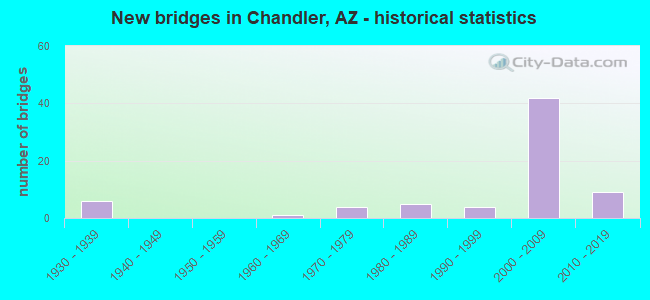
- New bridges - historical statistics
- 61930-1939
- 11960-1969
- 41970-1979
- 51980-1989
- 41990-1999
- 422000-2009
- 92010-2019
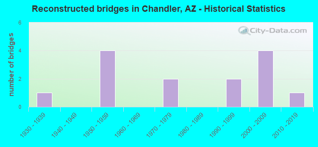
- Reconstructed bridges - Historical Statistics
- 11930-1939
- 01940-1949
- 41950-1959
- 01960-1969
- 21970-1979
- 01980-1989
- 21990-1999
- 42000-2009
- 12010-2019
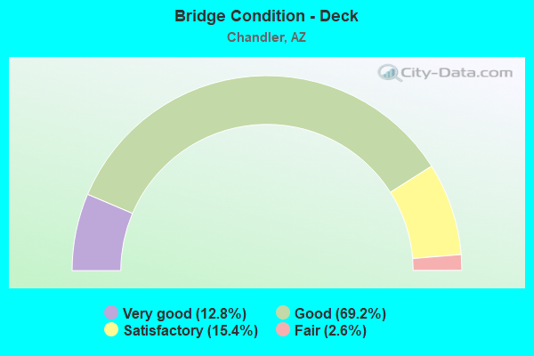
- Bridge Condition - Deck
- 12.8%Very good
- 69.2%Good
- 15.4%Satisfactory
- 2.6%Fair

- Bridge Condition - Superstructure
- 28.2%Very good
- 53.8%Good
- 15.4%Satisfactory
- 2.6%Fair
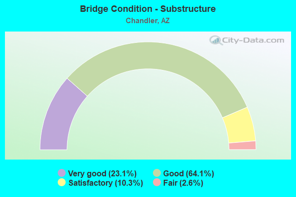
- Bridge Condition - Substructure
- 23.1%Very good
- 64.1%Good
- 10.3%Satisfactory
- 2.6%Fair
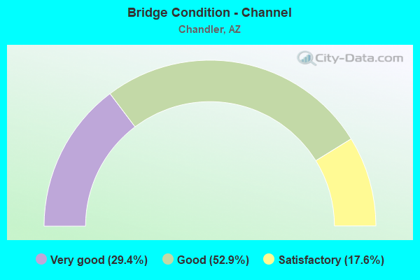
- Bridge Condition - Channel
- 29.4%Very good
- 52.9%Good
- 17.6%Satisfactory
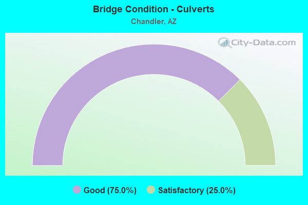
- Bridge Condition - Culverts
- 75.0%Good
- 25.0%Satisfactory
Find on map >> Show street view
Structure Number: 11143, Location: 0.2 mi S Jct Queen Crk Rd (Lat: 33.258917, Lng: -111.824139), Route carried "on" structure: City street , Year Built: 2010, Status: Open, Structure Length: 1.10m (3.61ft), Average Daily Traffic: 20,773 (year 2019), Truck Traffic: 5%, Average Future Daily Traffic: 20,783 (year 2039), Design Load: HS 20, Features Intersected: Consolidated Canal, Facility Carried by Structure: McQueen Rd
Minimum Vertical Clearance: 30+ m (98+ ft), Kilometerpoint: 0.000, Lanes on structure: 7, Owner: City or Municipal Highway Agency, Approaching Roadway Width: 29.3m (96.1ft), Skew: 6 degrees, Material/Design: Concrete, Design/Construction: Frame, Number Of Spans In Main Unit: 1, Length of Maximum Span: 10.4m (34.1ft), Curb or Sidewalk Widths: Left: 3.2m (10.5ft), Right: 2.0m (6.6ft), Curb-To-Curb Width: 29.3m (96.1ft), Out-to-Out Width: 36.3m (119.1ft)
Condition: Deck: Good, Superstructure: Good, Substructure: Very good, Channel: Very good, Operating Rating: 54.4 metric tons, Method Used To Determine Operating Rating: Field evaluation and documented engineering judgment, Inventory Rating: 32.7 metric tons, Method Used To Determine Inventory Rating: Field evaluation and documented engineering judgment, Structural Evaluation: Better than present minimum criteria, Deck Geometry: Somewhat better than minimum adequacy, Waterway Adequacy: Equal to present desirable criteria, Approach Roadway Alignment: Equal to present desirable criteria, Designated Inspection Frequency: Every 24 months, Inspection Date: December 2021, Deck Structure Type: Concrete Cast-file-Place, Wearing Surface/Protective System: Wearing Surface: Monolithic Concrete
Find on map >> Show street view
Structure Number: 2288, Location: 4.5 mi S/ 60 & 4.5E/ I 17 (Lat: 33.320300, Lng: -111.894700), Route carried "under" structure: State highway 101, Year Built: 2001, Structure Length: 0. m, Average Daily Traffic: 183,521 (year 2019), Truck Traffic: 5%, Features Intersected: SR 101L, Facility Carried by Structure: Ray Road
Minimum Vertical Clearance: 5.42m (17.78ft), Kilometerpoint: 95.901, Lanes on structure: 10, Lanes under structure: 10, Material/Design: Prestressed concrete continuous, Design/Construction: Box Beam or Girders - Single/Spread, Length of Maximum Span: 38.1m (125.0ft)
Find on map >> Show street view
Structure Number: 2302, Location: 8.1 mi S of Jct US 60 (Lat: 33.255000, Lng: -111.949200), Route carried "under" structure: Interstate 10, Year Built: 1991, Structure Length: 0. m, Average Daily Traffic: 104,778 (year 2017), Truck Traffic: 11%, Features Intersected: I 10, Facility Carried by Structure: Queen Creek Rd
Minimum Vertical Clearance: 5.15m (16.90ft), Kilometerpoint: 264.737, Lanes on structure: 7, Lanes under structure: 4, Material/Design: Prestressed concrete continuous, Design/Construction: Stringer/Multi-beam, Length of Maximum Span: 39.6m (129.9ft)
Find on map >> Show street view
Structure Number: 2328, Location: Est 5.5 mi S of US 60 (Lat: 33.305700, Lng: -111.894300), Route carried "under" structure: City street , Year Built: 2000, Structure Length: 0. m, Average Daily Traffic: 21,500 (year 2017), Truck Traffic: 7%, Features Intersected: Chandler Blvd, Facility Carried by Structure: SR 101 L
Minimum Vertical Clearance: 5.05m (16.57ft), Kilometerpoint: 0.000, Lanes on structure: 9, Lanes under structure: 9, Material/Design: Prestressed concrete continuous, Design/Construction: Stringer/Multi-beam, Length of Maximum Span: 30.5m (100.1ft)
Find on map >> Show street view
Structure Number: 2329, Location: 6.4 mi S of Jct US 60 (Lat: 33.298500, Lng: -111.894900), Route carried "under" structure: State highway 101, Year Built: 1995, Structure Length: 0. m, Average Daily Traffic: 115,169 (year 2019), Truck Traffic: 7%, Features Intersected: SL 101(Price Road), Facility Carried by Structure: Frye Road
Minimum Vertical Clearance: 5.09m (16.70ft), Kilometerpoint: 98.299, Lanes on structure: 6, Lanes under structure: 6, Material/Design: Prestressed concrete continuous, Design/Construction: Box Beam or Girders - Single/Spread, Length of Maximum Span: 58.8m (192.9ft)
Find on map >> Show street view
Structure Number: 2589, Location: 0.7 mi S Chandler Blvd (Lat: 33.295167, Lng: -111.963139), Route carried "under" structure: Business City street , Year Built: 2003, Structure Length: 0. m, Average Daily Traffic: 17,200 (year 2019), Truck Traffic: 5%, Features Intersected: 56th Street, Facility Carried by Structure: Santan Freeway
Minimum Vertical Clearance: 6.81m (22.34ft), Kilometerpoint: 0.000, Lanes on structure: 2, Lanes under structure: 2, Material/Design: Prestressed concrete continuous, Design/Construction: Box Beam or Girders - Single/Spread, Length of Maximum Span: 44.2m (145.0ft)
Find on map >> Show street view
Structure Number: 259, Location: 0.7 mi S Chandler Blvrd (Lat: 33.295556, Lng: -111.963139), Route carried "under" structure: Business City street 56, Year Built: 2003, Structure Length: 0. m, Average Daily Traffic: 17,200 (year 2020), Truck Traffic: 5%, Features Intersected: 56th Street, Facility Carried by Structure: Santan Freeway
Minimum Vertical Clearance: 7.10m (23.29ft), Kilometerpoint: 0.000, Lanes on structure: 4, Lanes under structure: 4, Material/Design: Prestressed concrete continuous, Design/Construction: Box Beam or Girders - Single/Spread, Length of Maximum Span: 45.1m (148.0ft)
Find on map >> Show street view
Structure Number: 2591, Location: 0.7 mi S Chandler Blvrd (Lat: 33.295556, Lng: -111.963139), Route carried "under" structure: Business City street , Year Built: 2003, Structure Length: 0. m, Average Daily Traffic: 17,200 (year 2017), Truck Traffic: 5%, Features Intersected: 56th Street, Facility Carried by Structure: Santan Freeway
Minimum Vertical Clearance: 6.74m (22.11ft), Kilometerpoint: 0.000, Lanes on structure: 3, Lanes under structure: 3, Material/Design: Prestressed concrete continuous, Design/Construction: Box Beam or Girders - Single/Spread, Length of Maximum Span: 45.1m (148.0ft)
Find on map >> Show street view
Structure Number: 2592, Location: 0.7 mi S Chandler Blvrd (Lat: 33.295889, Lng: -111.963139), Route carried "under" structure: Business City street , Year Built: 2003, Structure Length: 0. m, Average Daily Traffic: 17,200 (year 2020), Truck Traffic: 5%, Features Intersected: 56th Street, Facility Carried by Structure: Santan Freeway
Minimum Vertical Clearance: 7.08m (23.23ft), Kilometerpoint: 0.000, Lanes on structure: 2, Lanes under structure: 2, Material/Design: Prestressed concrete continuous, Design/Construction: Box Beam or Girders - Single/Spread, Length of Maximum Span: 46.6m (152.9ft)
Find on map >> Show street view
Structure Number: 2612, Location: Gila River Indi (Lat: 33.279561, Lng: -111.966800), Route carried "under" structure: Interstate 10, Year Built: 2004, Structure Length: 0. m, Average Daily Traffic: 104,778 (year 2017), Truck Traffic: 11%, Features Intersected: I 10, Facility Carried by Structure: Wild Horse Pass Bl
Minimum Vertical Clearance: 5.29m (17.36ft), Kilometerpoint: 261.583, Lanes on structure: 7, Lanes under structure: 6, Material/Design: Prestressed concrete continuous, Design/Construction: Stringer/Multi-beam, Length of Maximum Span: 41.8m (137.1ft)
Find on map >> Show street view
Structure Number: 2613, Location: Price Road and 202 L (Lat: 33.292194, Lng: -111.892694), Route carried "under" structure: State highway 202, Year Built: 2003, Structure Length: 0. m, Average Daily Traffic: 80,393 (year 2018), Truck Traffic: 7%, Features Intersected: SR 202L, Facility Carried by Structure: Price Road
Minimum Vertical Clearance: 5.99m (19.65ft), Kilometerpoint: 81.513, Lanes on structure: 10, Lanes under structure: 10, Material/Design: Prestressed concrete continuous, Design/Construction: Box Beam or Girders - Single/Spread, Length of Maximum Span: 39.3m (128.9ft)
Find on map >> Show street view
Structure Number: 2614, Location: 1 mi W of L101/L202 (Lat: 33.292000, Lng: -111.902333), Route carried "under" structure: State highway 202, Year Built: 2004, Structure Length: 0. m, Average Daily Traffic: 91,509 (year 2016), Truck Traffic: 8%, Features Intersected: SR 202L, Facility Carried by Structure: Chandler Village D
Minimum Vertical Clearance: 5.48m (17.98ft), Kilometerpoint: 82.431, Lanes on structure: 5, Lanes under structure: 5, Material/Design: Prestressed concrete continuous, Design/Construction: Box Beam or Girders - Single/Spread, Length of Maximum Span: 50.6m (166.0ft)
Find on map >> Show street view
Structure Number: 2615, Location: 0.25 mi N of L101/L202 (Lat: 33.295900, Lng: -111.894500), Route carried "under" structure: State highway 101, Year Built: 2003, Structure Length: 0. m, Average Daily Traffic: 21,800 (year 2019), Truck Traffic: 7%, Features Intersected: SB Frontage Road
Minimum Vertical Clearance: 5.18m (16.99ft), Kilometerpoint: 97.735, Lanes on structure: 3, Lanes under structure: 3, Material/Design: Prestressed concrete continuous, Design/Construction: Box Beam or Girders - Single/Spread, Length of Maximum Span: 54.9m (180.1ft)
Find on map >> Show street view
Structure Number: 2617, Location: 0.25 mi N of L101/L202 (Lat: 33.295200, Lng: -111.894100), Route carried "under" structure: ServiceState highway 101, Year Built: 2004, Structure Length: 0. m, Average Daily Traffic: 25,756 (year 2021), Truck Traffic: 7%, Features Intersected: SB Frontage Road, Facility Carried by Structure: Ramp S-W
Minimum Vertical Clearance: 5.31m (17.42ft), Kilometerpoint: 97.848, Lanes on structure: 1, Lanes under structure: 3, Material/Design: Prestressed concrete continuous, Design/Construction: Box Beam or Girders - Single/Spread, Length of Maximum Span: 36.6m (120.1ft)
Find on map >> Show street view
Structure Number: 2672, Location: McQueen Rd/L202 intersect (Lat: 33.282200, Lng: -111.824100), Route carried "under" structure: State highway 202, Year Built: 2005, Structure Length: 0. m, Average Daily Traffic: 149,651 (year 2018), Truck Traffic: 7%, Features Intersected: Santan Freeway (202L), Facility Carried by Structure: McQueen Road
Minimum Vertical Clearance: 5.70m (18.70ft), Kilometerpoint: 74.995, Lanes on structure: 9, Lanes under structure: 5, Material/Design: Prestressed concrete continuous, Design/Construction: Box Beam or Girders - Single/Spread, Length of Maximum Span: 39.6m (129.9ft)
Find on map >> Show street view
Structure Number: 2674, Location: Cooper Rd /L 202 Chandler (Lat: 33.282400, Lng: -111.806800), Route carried "under" structure: State highway 202, Year Built: 2005, Structure Length: 0. m, Average Daily Traffic: 144,103 (year 2018), Truck Traffic: 7%, Features Intersected: Santan Freeway (202L), Facility Carried by Structure: Cooper Road, NB
Minimum Vertical Clearance: 5.47m (17.95ft), Kilometerpoint: 73.225, Lanes on structure: 9, Lanes under structure: 8, Material/Design: Prestressed concrete continuous, Design/Construction: Box Beam or Girders - Single/Spread, Length of Maximum Span: 39.0m (128.0ft)
Find on map >> Show street view
Structure Number: 2689, Location: 1mi W AlmaSchoolRd & 202L (Lat: 33.287250, Lng: -111.876250), Route carried "under" structure: State highway 202, Year Built: 2004, Structure Length: 0. m, Average Daily Traffic: 162,804 (year 2018), Truck Traffic: 7%, Features Intersected: L202, Facility Carried by Structure: Dobson Rd
Minimum Vertical Clearance: 5.81m (19.06ft), Kilometerpoint: 79.888, Lanes on structure: 7, Lanes under structure: 10, Material/Design: Prestressed concrete continuous, Design/Construction: Box Beam or Girders - Single/Spread, Length of Maximum Span: 36.0m (118.1ft)
Find on map >> Show street view
Structure Number: 2692, Location: 1 mi Eof Dobson Rd & 202L (Lat: 33.286600, Lng: -111.858800), Route carried "under" structure: State highway 202, Year Built: 2004, Structure Length: 0. m, Average Daily Traffic: 162,804 (year 2018), Truck Traffic: 7%, Features Intersected: SR 202L, Facility Carried by Structure: Alma School Road
Minimum Vertical Clearance: 5.56m (18.24ft), Kilometerpoint: 78.278, Lanes on structure: 10, Lanes under structure: 8, Material/Design: Prestressed concrete continuous, Design/Construction: Box Beam or Girders - Multiple, Length of Maximum Span: 31.4m (103.0ft)
Find on map >> Show street view
Structure Number: 2693, Location: 1 mi E AlmaSchool & 202L (Lat: 33.287306, Lng: -111.841500), Route carried "under" structure: City street , Year Built: 2004, Structure Length: 0. m, Average Daily Traffic: 45,400 (year 2019), Truck Traffic: 8%, Features Intersected: Arizona Avenue, Facility Carried by Structure: SR 202L
Minimum Vertical Clearance: 6.40m (21.00ft), Kilometerpoint: 0.000, Lanes on structure: 8, Lanes under structure: 9, Material/Design: Prestressed concrete continuous, Design/Construction: Box Beam or Girders - Multiple, Length of Maximum Span: 24.7m (81.0ft)
Find on map >> Show street view
Structure Number: 2713, Location: Intersect. I-10 @ Santan (Lat: 33.295839, Lng: -111.975700), Route carried "under" structure: Ramp State highway 202, Year Built: 2002, Structure Length: 0. m, Average Daily Traffic: 101,234 (year 2015), Truck Traffic: 12%, Features Intersected: I10,202 & Ramps N-W,S-E
Minimum Vertical Clearance: 7.48m (24.54ft), Kilometerpoint: 259.426, Lanes on structure: 1, Lanes under structure: 17, Material/Design: Prestressed concrete continuous, Design/Construction: Box Beam or Girders - Single/Spread, Length of Maximum Span: 71.0m (232.9ft)
Find on map >> Show street view
Structure Number: 2714, Location: Intersect. I-10 @ Santan (Lat: 33.298031, Lng: -111.970700), Route carried "under" structure: Interstate 10, Year Built: 2003, Structure Length: 0. m, Average Daily Traffic: 89,395 (year 2017), Truck Traffic: 4%, Features Intersected: I-10, 202, Ramps SE,NW,C
Minimum Vertical Clearance: 6.51m (21.36ft), Kilometerpoint: 259.539, Lanes on structure: 1, Lanes under structure: 17, Material/Design: Prestressed concrete continuous, Design/Construction: Box Beam or Girders - Single/Spread, Length of Maximum Span: 49.4m (162.1ft)
Find on map >> Show street view
Structure Number: 2715, Location: TI , I 10 and 202L,Chndlr (Lat: 33.299800, Lng: -111.972700), Route carried "under" structure: Interstate 10, Year Built: 2003, Structure Length: 0. m, Average Daily Traffic: 89,395 (year 2017), Truck Traffic: 4%, Features Intersected: 10,202 & C
Minimum Vertical Clearance: 5.67m (18.60ft), Kilometerpoint: 259.362, Lanes on structure: 2, Lanes under structure: 12, Material/Design: Prestressed concrete continuous, Design/Construction: Box Beam or Girders - Single/Spread, Length of Maximum Span: 78.3m (256.9ft)
Find on map >> Show street view
Structure Number: 2718, Location: Intersect. I-10 @ Santan (Lat: 33.296353, Lng: -111.970753), Route carried "under" structure: Interstate 10, Year Built: 2003, Structure Length: 0. m, Average Daily Traffic: 89,395 (year 2017), Truck Traffic: 4%, Features Intersected: I-10, L202, Ramp C
Minimum Vertical Clearance: 5.70m (18.70ft), Kilometerpoint: 259.619, Lanes on structure: 1, Lanes under structure: 13, Material/Design: Prestressed concrete continuous, Design/Construction: Box Beam or Girders - Single/Spread, Length of Maximum Span: 48.8m (160.1ft)
Find on map >> Show street view
Structure Number: 2719, Location: Intersect. I-10 @ Santan (Lat: 33.300964, Lng: -111.973186), Route carried "under" structure: Ramp City street 10, Year Built: 2003, Structure Length: 0. m, Average Daily Traffic: 4,000 (year 2019), Truck Traffic: 6%, Features Intersected: Chandler Ramp D
Minimum Vertical Clearance: 5.91m (19.39ft), Kilometerpoint: 259.298, Lanes on structure: 2, Lanes under structure: 2, Material/Design: Prestressed concrete continuous, Design/Construction: Box Beam or Girders - Single/Spread, Length of Maximum Span: 44.2m (145.0ft)
Find on map >> Show street view
Structure Number: 272, Location: Intersect. I-10 @ Santan (Lat: 33.299408, Lng: -111.970969), Route carried "under" structure: Ramp Interstate 10, Year Built: 2003, Structure Length: 0. m, Average Daily Traffic: 8,939 (year 2017), Truck Traffic: 4%, Features Intersected: Chandler Ramp C
Minimum Vertical Clearance: 9.96m (32.68ft), Kilometerpoint: 259.362, Lanes on structure: 2, Lanes under structure: 2, Material/Design: Prestressed concrete continuous, Design/Construction: Box Beam or Girders - Single/Spread, Length of Maximum Span: 45.7m (149.9ft)
Find on map >> Show street view
Structure Number: 2991, Location: TI, 101L and 202L Chndlr (Lat: 33.295600, Lng: -111.894200), Route carried "under" structure: State highway 202, Year Built: 2011, Structure Length: 0. m, Average Daily Traffic: 186,471 (year 2019), Truck Traffic: 6%, Features Intersected: 202L Santan Fwy
Minimum Vertical Clearance: 7.93m (26.02ft), Kilometerpoint: 81.417, Lanes on structure: 2, Lanes under structure: 2, Material/Design: Prestressed concrete continuous, Design/Construction: Stringer/Multi-beam, Length of Maximum Span: 41.1m (134.8ft)
Find on map >> Show street view
Structure Number: 2992, Location: I-10/202 TI (Lat: 33.299500, Lng: -111.972200), Route carried "under" structure: Interstate 10, Year Built: 2012, Structure Length: 0. m, Average Daily Traffic: 50,617 (year 2017), Truck Traffic: 4%, Features Intersected: I-10 Papago Fwy
Minimum Vertical Clearance: 5.84m (19.16ft), Kilometerpoint: 259.426, Lanes on structure: 2, Lanes under structure: 5, Material/Design: Prestressed concrete continuous, Design/Construction: Stringer/Multi-beam, Length of Maximum Span: 40.8m (133.9ft)
Find on map >> Show street view
Structure Number: 2993, Location: Intersect. I-10 at Santan (Lat: 33.297033, Lng: -111.970233), Route carried "under" structure: State highway 202, Year Built: 2011, Structure Length: 0. m, Average Daily Traffic: 80,418 (year 2020), Truck Traffic: 7%, Features Intersected: 202L Santan Fwy
Minimum Vertical Clearance: 6.31m (20.70ft), Kilometerpoint: 88.884, Lanes on structure: 2, Lanes under structure: 2, Material/Design: Prestressed concrete continuous, Design/Construction: Box Beam or Girders - Single/Spread, Length of Maximum Span: 61.9m (203.1ft)
Find on map >> Show street view
Structure Number: 108, Location: S of Ray Rd (Lat: 33.312900, Lng: -111.894900), Route carried "under" structure: State highway 101, Year Built: 2013, Structure Length: 0. m, Average Daily Traffic: 157,435 (year 2018), Truck Traffic: 7%, Features Intersected: SR 101L, Facility Carried by Structure: Galveston St Ped
Minimum Vertical Clearance: 5.61m (18.41ft), Kilometerpoint: 95.960, Material/Design: Steel continuous, Design/Construction: Box Beam or Girders - Multiple, Length of Maximum Span: 39.3m (128.9ft)