Bridge Statistics for Casper, Wyoming (WY)
Condition, Traffic, Stress, Structural Evaluation, Project Costs
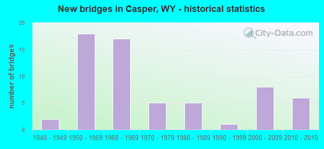
- New bridges - historical statistics
- 21940-1949
- 181950-1959
- 171960-1969
- 51970-1979
- 51980-1989
- 11990-1999
- 82000-2009
- 62010-2019
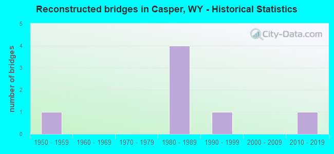
- Reconstructed bridges - Historical Statistics
- 11950-1959
- 01960-1969
- 01970-1979
- 41980-1989
- 11990-1999
- 02000-2009
- 12010-2019
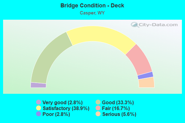
- Bridge Condition - Deck
- 2.8%Very good
- 33.3%Good
- 38.9%Satisfactory
- 16.7%Fair
- 2.8%Poor
- 5.6%Serious
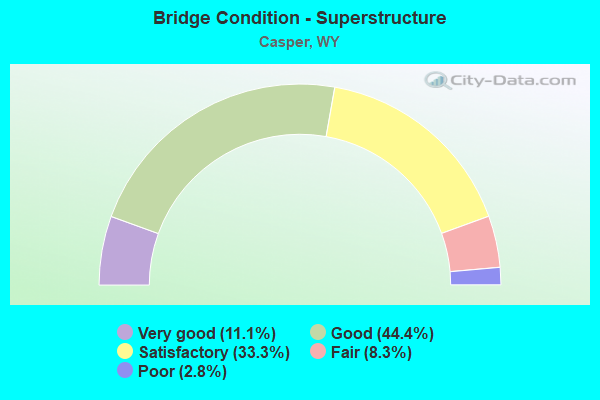
- Bridge Condition - Superstructure
- 11.1%Very good
- 44.4%Good
- 33.3%Satisfactory
- 8.3%Fair
- 2.8%Poor
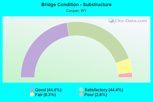
- Bridge Condition - Substructure
- 44.4%Good
- 44.4%Satisfactory
- 8.3%Fair
- 2.8%Poor
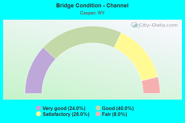
- Bridge Condition - Channel
- 24.0%Very good
- 40.0%Good
- 28.0%Satisfactory
- 8.0%Fair
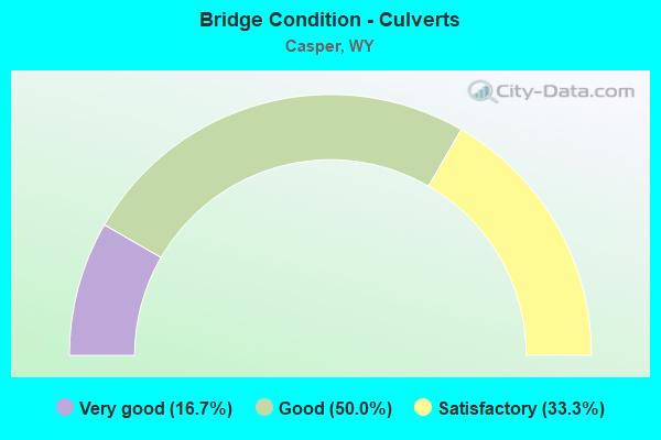
- Bridge Condition - Culverts
- 16.7%Very good
- 50.0%Good
- 33.3%Satisfactory
Find on map >> Show street view
Structure Number: MMB, Location: Casper (Lat: 42.864381, Lng: -106.360892), Route carried "on" structure: State highway 254, Year Built: 2015, Status: Open, Structure Length: 8.53m (27.99ft), Average Daily Traffic: 6,329 (year 2021), Truck Traffic: 7%, Average Future Daily Traffic: 8,861 (year 2041), Design Load: HL 93, Features Intersected: US 20/26 Bypass
Minimum Vertical Clearance: 30+ m (98+ ft), Kilometerpoint: 2.211, Lanes on structure: 5, Lanes under structure: 4, Owner: State Highway Agency, Approaching Roadway Width: 21.9m (71.9ft), Skew: 3 degrees, Material/Design: Steel continuous, Design/Construction: Stringer/Multi-beam, Number Of Spans In Main Unit: 2, Length of Maximum Span: 42.1m (138.1ft), Curb or Sidewalk Widths: Left: 2.3m (7.5ft), Right: 1.3m (4.3ft), Curb-To-Curb Width: 21.9m (71.9ft), Out-to-Out Width: 27.1m (88.9ft)
Condition: Deck: Good, Superstructure: Very good, Substructure: Good, Operating Rating: 53.5 metric tons, Method Used To Determine Operating Rating: Load and Resistance Factor Rating (LRFR) rating reported by rating factor(RF) method using HL-93 loadings, Inventory Rating: 41.1 metric tons, Method Used To Determine Inventory Rating: Load and Resistance Factor Rating (LRFR) rating reported by rating factor(RF) method using HL-93 loadings, Structural Evaluation: Better than present minimum criteria, Deck Geometry: Somewhat better than minimum adequacy, Underclear: Meets minimum limits, Approach Roadway Alignment: Equal to present desirable criteria, Designated Inspection Frequency: Every 24 months, Inspection Date: April 2021, Deck Structure Type: Concrete Precast Panels, Wearing Surface/Protective System: Wearing Surface: Epoxy Overlay, Deck Protection: Epoxy Coated Reinforcing
Find on map >> Show street view
Structure Number: MPP, Location: Casper (Lat: 42.827836, Lng: -106.415572), Route carried "on" structure: City street 4131, Year Built: 2015, Status: Open, Structure Length: 0.70m (2.30ft), Average Daily Traffic: 7,838 (year 2021), Truck Traffic: 1%, Average Future Daily Traffic: 10,973 (year 2041), Design Load: HL 93, Features Intersected: Unnamed Draw, Facility Carried by Structure: Na Cnty Rd 305
Minimum Vertical Clearance: 30+ m (98+ ft), Kilometerpoint: 2.194, Lanes on structure: 2, Owner: Town or Township Highway Agency, Approaching Roadway Width: 9.1m (29.9ft), Skew: 2 degrees, Material/Design: Concrete, Design/Construction: Culvert, Number Of Spans In Main Unit: 2, Length of Maximum Span: 3.0m (9.8ft)
Condition: Channel: Very good, Culverts: Good, Operating Rating: 32.7 metric tons, Method Used To Determine Operating Rating: Field evaluation and documented engineering judgment, Inventory Rating: 32.7 metric tons, Method Used To Determine Inventory Rating: Field evaluation and documented engineering judgment, Structural Evaluation: Better than present minimum criteria, Waterway Adequacy: Equal to present desirable criteria, Approach Roadway Alignment: Equal to present desirable criteria, Designated Inspection Frequency: Every 24 months, Inspection Date: August 2021
Find on map >> Show street view
Structure Number: AIA, Location: Casper (Lat: 42.856708, Lng: -106.294139), Route carried "under" structure: Interstate 25, Year Built: 1958, Structure Length: 0. m, Average Daily Traffic: 8,147 (year 2021), Truck Traffic: 20%, Features Intersected: I-25, Facility Carried by Structure: BNSF Railway
Minimum Vertical Clearance: 4.57m (14.99ft), Kilometerpoint: 299.838, Lanes under structure: 2, Material/Design: Steel, Design/Construction: Truss - Thru, Length of Maximum Span: 46.9m (153.9ft)
Find on map >> Show street view
Structure Number: AIA, Location: Casper (Lat: 42.856708, Lng: -106.294139), Route carried "under" structure: Interstate 25, Year Built: 1958, Structure Length: 0. m, Average Daily Traffic: 8,168 (year 2021), Truck Traffic: 20%, Features Intersected: I-25, Facility Carried by Structure: BNSF Railway
Minimum Vertical Clearance: 4.83m (15.85ft), Kilometerpoint: 299.853, Lanes under structure: 2, Material/Design: Steel, Design/Construction: Truss - Thru, Length of Maximum Span: 46.9m (153.9ft)
Find on map >> Show street view
Structure Number: AIB, Location: Bryan Stock Trail Casper (Lat: 42.857675, Lng: -106.297575), Route carried "under" structure: Interstate 25, Year Built: 1960, Structure Length: 0. m, Average Daily Traffic: 10,836 (year 2021), Truck Traffic: 16%, Features Intersected: I-25, Facility Carried by Structure: N. Beverly Street
Minimum Vertical Clearance: 4.60m (15.09ft), Kilometerpoint: 300.141, Lanes on structure: 4, Lanes under structure: 2, Material/Design: Concrete, Design/Construction: Frame, Length of Maximum Span: 28.0m (91.9ft)
Find on map >> Show street view
Structure Number: AIB, Location: Bryan Stock Trail Casper (Lat: 42.857675, Lng: -106.297575), Route carried "under" structure: Interstate 25, Year Built: 1960, Structure Length: 0. m, Average Daily Traffic: 10,671 (year 2021), Truck Traffic: 20%, Features Intersected: I-25, Facility Carried by Structure: N. Beverly Street
Minimum Vertical Clearance: 5.08m (16.67ft), Kilometerpoint: 300.149, Lanes on structure: 4, Lanes under structure: 2, Material/Design: Concrete, Design/Construction: Frame, Length of Maximum Span: 28.0m (91.9ft)
Find on map >> Show street view
Structure Number: AIF, Location: Casper (Lat: 42.857022, Lng: -106.311906), Route carried "under" structure: City street 4125, Year Built: 1958, Structure Length: 0. m, Average Daily Traffic: 5,194 (year 2021), Truck Traffic: 4%, Features Intersected: North Mckinley Street, Facility Carried by Structure: I-25 NBL
Minimum Vertical Clearance: 4.54m (14.90ft), Kilometerpoint: 0.021, Lanes on structure: 2, Lanes under structure: 4, Material/Design: Steel continuous, Design/Construction: Stringer/Multi-beam, Length of Maximum Span: 14.3m (46.9ft)
Find on map >> Show street view
Structure Number: AIH, Location: Casper (Lat: 42.857039, Lng: -106.324864), Route carried "under" structure: City street 9016, Year Built: 1958, Structure Length: 0. m, Average Daily Traffic: 9,980 (year 2021), Truck Traffic: 5%, Features Intersected: N Center Street, Facility Carried by Structure: I-25 NBL
Minimum Vertical Clearance: 4.44m (14.57ft), Kilometerpoint: 0.002, Lanes on structure: 2, Lanes under structure: 4, Material/Design: Steel continuous, Design/Construction: Stringer/Multi-beam, Length of Maximum Span: 14.3m (46.9ft)
Find on map >> Show street view
Structure Number: BMA, Location: Casper (Lat: 42.855547, Lng: -106.291775), Route carried "under" structure: Interstate 25, Year Built: 1960, Structure Length: 0. m, Average Daily Traffic: 10,671 (year 2021), Truck Traffic: 20%, Features Intersected: I-25, Facility Carried by Structure: Hereford Lane
Minimum Vertical Clearance: 4.59m (15.06ft), Kilometerpoint: 299.621, Lanes on structure: 2, Lanes under structure: 2, Material/Design: Concrete, Design/Construction: Frame, Length of Maximum Span: 26.2m (86.0ft)
Find on map >> Show street view
Structure Number: BMA, Location: Casper (Lat: 42.855547, Lng: -106.291775), Route carried "under" structure: Interstate 25, Year Built: 1960, Structure Length: 0. m, Average Daily Traffic: 8,147 (year 2021), Truck Traffic: 20%, Features Intersected: I-25, Facility Carried by Structure: Hereford Lane
Minimum Vertical Clearance: 5.19m (17.03ft), Kilometerpoint: 299.607, Lanes on structure: 2, Lanes under structure: 2, Material/Design: Concrete, Design/Construction: Frame, Length of Maximum Span: 26.2m (86.0ft)
Find on map >> Show street view
Structure Number: CWZ, Location: East Yellowstone Casper (Lat: 42.855378, Lng: -106.289175), Route carried "under" structure: Interstate 25, Year Built: 1968, Structure Length: 0. m, Average Daily Traffic: 5,862 (year 2021), Truck Traffic: 30%, Features Intersected: I-25, Facility Carried by Structure: US 20/26/87 WBL
Minimum Vertical Clearance: 5.69m (18.67ft), Kilometerpoint: 299.398, Lanes on structure: 5, Lanes under structure: 2, Material/Design: Steel continuous, Design/Construction: Stringer/Multi-beam, Length of Maximum Span: 48.8m (160.1ft)
Find on map >> Show street view
Structure Number: CWZ, Location: East Yellowstone Casper (Lat: 42.855378, Lng: -106.289175), Route carried "under" structure: Interstate 25, Year Built: 1968, Structure Length: 0. m, Average Daily Traffic: 3,842 (year 2021), Truck Traffic: 20%, Features Intersected: I-25, Facility Carried by Structure: US 20/26/87 WBL
Minimum Vertical Clearance: 5.69m (18.67ft), Kilometerpoint: 299.409, Lanes on structure: 5, Lanes under structure: 2, Material/Design: Steel continuous, Design/Construction: Stringer/Multi-beam, Length of Maximum Span: 48.8m (160.1ft)
Find on map >> Show street view
Structure Number: CYH, Location: Center Street Casper (Lat: 42.853917, Lng: -106.325172), Route carried "under" structure: Business US 25, Year Built: 1941, Structure Length: 0. m, Average Daily Traffic: 9,980 (year 2021), Truck Traffic: 5%, Features Intersected: North Center Street, Facility Carried by Structure: BNSF Railway
Minimum Vertical Clearance: 3.96m (12.99ft), Kilometerpoint: 161.359, Lanes under structure: 2, Material/Design: Steel, Design/Construction: Stringer/Multi-beam, Length of Maximum Span: 10.4m (34.1ft)
Find on map >> Show street view
Structure Number: DKU, Location: Mckinley Street Int (Lat: 42.856936, Lng: -106.311908), Route carried "under" structure: City street 4125, Year Built: 1958, Structure Length: 0. m, Average Daily Traffic: 5,194 (year 2021), Truck Traffic: 4%, Features Intersected: North Mckinley Street, Facility Carried by Structure: I-25 SBL
Minimum Vertical Clearance: 4.54m (14.90ft), Kilometerpoint: 0.031, Lanes on structure: 2, Lanes under structure: 4, Material/Design: Steel continuous, Design/Construction: Stringer/Multi-beam, Length of Maximum Span: 14.3m (46.9ft)
Find on map >> Show street view
Structure Number: DKV, Location: Casper (Lat: 42.856986, Lng: -106.324864), Route carried "under" structure: Business State highway 255, Year Built: 1958, Structure Length: 0. m, Average Daily Traffic: 9,980 (year 2021), Truck Traffic: 5%, Features Intersected: N Center Street, Facility Carried by Structure: I-25 SBL
Minimum Vertical Clearance: 4.44m (14.57ft), Kilometerpoint: 1.046, Lanes on structure: 2, Lanes under structure: 4, Material/Design: Steel continuous, Design/Construction: Stringer/Multi-beam, Length of Maximum Span: 14.3m (46.9ft)
Find on map >> Show street view
Structure Number: DVE, Location: Mckinley Street Casper (Lat: 42.855044, Lng: -106.312200), Route carried "under" structure: City street , Year Built: 1945, Structure Length: 0. m, Average Daily Traffic: 5,194 (year 2021), Truck Traffic: 4%, Features Intersected: North Mckinley Street, Facility Carried by Structure: BNSF Railway
Minimum Vertical Clearance: 3.43m (11.25ft), Kilometerpoint: 161.490, Lanes under structure: 2, Material/Design: Wood or Timber, Design/Construction: Stringer/Multi-beam, Length of Maximum Span: 5.2m (17.1ft)
Find on map >> Show street view
Structure Number: FDG, Location: Casper (Lat: 42.857511, Lng: -106.333203), Route carried "under" structure: State highway 220, Year Built: 1985, Structure Length: 0. m, Average Daily Traffic: 16,111 (year 2021), Truck Traffic: 1%, Features Intersected: WYO 220, Facility Carried by Structure: I-25 NBL
Minimum Vertical Clearance: 5.12m (16.80ft), Kilometerpoint: 188.333, Lanes on structure: 2, Lanes under structure: 6, Material/Design: Steel continuous, Design/Construction: Stringer/Multi-beam, Length of Maximum Span: 28.3m (92.8ft)
Find on map >> Show street view
Structure Number: FDH, Location: Casper (Lat: 42.857389, Lng: -106.333286), Route carried "under" structure: State highway 220, Year Built: 1985, Structure Length: 0. m, Average Daily Traffic: 16,111 (year 2021), Truck Traffic: 1%, Features Intersected: WYO 220, Facility Carried by Structure: I-25 SBL
Minimum Vertical Clearance: 4.89m (16.04ft), Kilometerpoint: 188.319, Lanes on structure: 2, Lanes under structure: 6, Material/Design: Steel continuous, Design/Construction: Stringer/Multi-beam, Length of Maximum Span: 28.3m (92.8ft)
Find on map >> Show street view
Structure Number: LXB, Location: I-25 Casper Marginal (Lat: 42.854022, Lng: -106.270350), Route carried "under" structure: State highway 258, Year Built: 2006, Structure Length: 0. m, Average Daily Traffic: 12,574 (year 2021), Truck Traffic: 2%, Features Intersected: WYO 258 / Wyoming Blvd, Facility Carried by Structure: I-25 NBL
Minimum Vertical Clearance: 5.55m (18.21ft), Kilometerpoint: 29.348, Lanes on structure: 2, Lanes under structure: 6, Material/Design: Steel continuous, Design/Construction: Stringer/Multi-beam, Length of Maximum Span: 38.1m (125.0ft)
Find on map >> Show street view
Structure Number: LXC, Location: I-25 Casper Marginal (Lat: 42.853797, Lng: -106.270356), Route carried "under" structure: State highway 258, Year Built: 2007, Structure Length: 0. m, Average Daily Traffic: 12,574 (year 2021), Truck Traffic: 2%, Features Intersected: WYO 258 / Wyoming Blvd, Facility Carried by Structure: I-25 SBL
Minimum Vertical Clearance: 5.55m (18.21ft), Kilometerpoint: 29.324, Lanes on structure: 2, Lanes under structure: 6, Material/Design: Steel continuous, Design/Construction: Stringer/Multi-beam, Length of Maximum Span: 38.1m (125.0ft)
Find on map >> Show street view
Structure Number: MMB, Location: Casper (Lat: 42.864381, Lng: -106.360892), Route carried "under" structure: US 20, Year Built: 2015, Structure Length: 0. m, Average Daily Traffic: 5,478 (year 2021), Truck Traffic: 13%, Features Intersected: US 20/26 Bypass, Facility Carried by Structure: WYO 254
Minimum Vertical Clearance: 5.26m (17.26ft), Kilometerpoint: 3.318, Lanes on structure: 5, Lanes under structure: 2, Material/Design: Steel continuous, Design/Construction: Stringer/Multi-beam, Length of Maximum Span: 42.1m (138.1ft)
Find on map >> Show street view
Structure Number: MMB, Location: Casper (Lat: 42.864381, Lng: -106.360892), Route carried "under" structure: Spur US 20, Year Built: 2015, Structure Length: 0. m, Average Daily Traffic: 5,959 (year 2021), Truck Traffic: 13%, Features Intersected: US 20/26 Bypass, Facility Carried by Structure: WYO 254
Minimum Vertical Clearance: 5.29m (17.36ft), Kilometerpoint: 3.306, Lanes on structure: 5, Lanes under structure: 2, Material/Design: Steel continuous, Design/Construction: Stringer/Multi-beam, Length of Maximum Span: 42.1m (138.1ft)