Bridge Statistics for Carthage, Texas (TX)
Condition, Traffic, Stress, Structural Evaluation, Project Costs
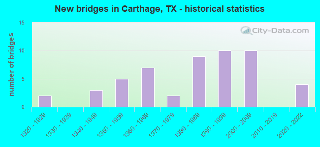
- New bridges - historical statistics
- 21920-1929
- 31940-1949
- 51950-1959
- 71960-1969
- 21970-1979
- 91980-1989
- 101990-1999
- 102000-2009
- 42020-2022

- Reconstructed bridges - Historical Statistics
- 11920-1929
- 01930-1939
- 01940-1949
- 21950-1959
- 01960-1969
- 01970-1979
- 31980-1989
- 21990-1999
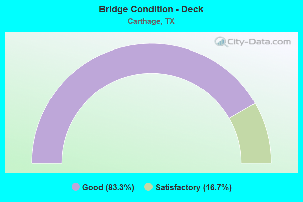
- Bridge Condition - Deck
- 83.3%Good
- 16.7%Satisfactory
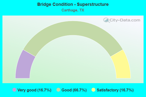
- Bridge Condition - Superstructure
- 16.7%Very good
- 66.7%Good
- 16.7%Satisfactory
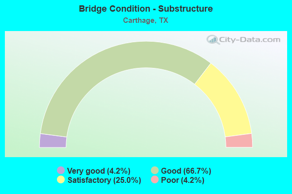
- Bridge Condition - Substructure
- 4.2%Very good
- 66.7%Good
- 25.0%Satisfactory
- 4.2%Poor
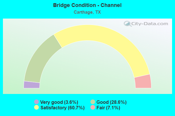
- Bridge Condition - Channel
- 3.6%Very good
- 28.6%Good
- 60.7%Satisfactory
- 7.1%Fair
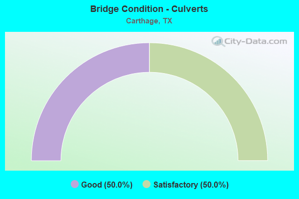
- Bridge Condition - Culverts
- 50.0%Good
- 50.0%Satisfactory
Find on map >> Show street view
Structure Number: 191830006302001, Location: 0.15 MI N OF FM 1794 (Lat: 32.313492, Lng: -94.288303), Route carried "on" structure: State highway 1186, Year Built: 2005, Status: Open, Structure Length: 14.63m (48.00ft), Average Daily Traffic: 415 (year 2020), Truck Traffic: 14%, Average Future Daily Traffic: 1,000 (year 2033), Design Load: HL 93, Features Intersected: CADDO CREEK
Minimum Vertical Clearance: 30+ m (98+ ft), Kilometerpoint: 3.082, Lanes on structure: 2, Owner: State Highway Agency, Approaching Roadway Width: 13.1m (43.0ft), Material/Design: Prestressed concrete, Design/Construction: Stringer/Multi-beam, Number Of Spans In Main Unit: 8, Length of Maximum Span: 18.6m (61.0ft), Curb-To-Curb Width: 13.2m (43.3ft), Out-to-Out Width: 14.0m (45.9ft)
Condition: Deck: Good, Superstructure: Very good, Substructure: Good, Channel: Satisfactory, Operating Rating: 54.4 metric tons, Method Used To Determine Operating Rating: Assigned ratings based on Load and Resistance Factor Design (LRFD) reported in metric tons, Inventory Rating: 32.7 metric tons, Method Used To Determine Inventory Rating: Assigned ratings based on Load and Resistance Factor Design (LRFD) reported in metric tons, Structural Evaluation: Better than present minimum criteria, Deck Geometry: Superior to present desirable criteria, Waterway Adequacy: Superior to present desirable criteria, Approach Roadway Alignment: Equal to present desirable criteria, Designated Inspection Frequency: Every 24 months, Inspection Date: June 2021, Deck Structure Type: Concrete Cast-file-Place
Find on map >> Show street view
Structure Number: 191830006303057, Location: 1.10 MI N OF US 79 (Lat: 32.174658, Lng: -94.324353), Route carried "on" structure: US 59, Year Built: 1969, Status: Open, Structure Length: 0.79m (2.59ft), Average Daily Traffic: 8,026 (year 2020), Truck Traffic: 22%, Average Future Daily Traffic: 15,980 (year 2033), Features Intersected: DRAIN
Minimum Vertical Clearance: 30+ m (98+ ft), Kilometerpoint: 33.976, Lanes on structure: 4, Owner: State Highway Agency, Approaching Roadway Width: 21.9m (71.9ft), Skew: 10 degrees, Material/Design: Concrete, Design/Construction: Culvert, Number Of Spans In Main Unit: 3, Length of Maximum Span: 2.4m (7.9ft)
Condition: Channel: Satisfactory, Culverts: Good, Operating Rating: 39.9 metric tons, Method Used To Determine Operating Rating: Load Factor (LF), Inventory Rating: 23.6 metric tons, Method Used To Determine Inventory Rating: Load Factor (LF), Structural Evaluation: Somewhat better than minimum adequacy, Waterway Adequacy: Superior to present desirable criteria, Approach Roadway Alignment: Equal to present desirable criteria, Designated Inspection Frequency: Every 24 months, Inspection Date: June 2021
Find on map >> Show street view
Structure Number: 191830006303058, Location: 0.65 MI N OF US 79 (Lat: 32.168422, Lng: -94.322442), Route carried "on" structure: US 59, Year Built: 1969, Status: Open, Structure Length: 1.65m (5.41ft), Average Daily Traffic: 8,026 (year 2020), Truck Traffic: 22%, Average Future Daily Traffic: 15,980 (year 2033), Design Load: HS 20, Features Intersected: HOGGS BAYOU
Minimum Vertical Clearance: 30+ m (98+ ft), Kilometerpoint: 34.681, Lanes on structure: 4, Owner: State Highway Agency, Approaching Roadway Width: 21.9m (71.9ft), Skew: 10 degrees, Material/Design: Concrete, Design/Construction: Culvert, Number Of Spans In Main Unit: 5, Length of Maximum Span: 3.0m (9.8ft)
Condition: Channel: Satisfactory, Culverts: Satisfactory, Operating Rating: 39.9 metric tons, Method Used To Determine Operating Rating: Load Factor (LF), Inventory Rating: 23.6 metric tons, Method Used To Determine Inventory Rating: Load Factor (LF), Structural Evaluation: Somewhat better than minimum adequacy, Waterway Adequacy: Superior to present desirable criteria, Approach Roadway Alignment: Equal to present desirable criteria, Designated Inspection Frequency: Every 24 months, Inspection Date: June 2021
Find on map >> Show street view
Structure Number: 191830006303059, Location: 0.80 MI N OF FM 699 (Lat: 32.158878, Lng: -94.320728), Route carried "on" structure: US 59, Year Built: 1969, Status: Open, Structure Length: 4.88m (16.01ft), Average Daily Traffic: 5,710 (year 2013), Truck Traffic: 22%, Average Future Daily Traffic: 7,990 (year 2033), Design Load: H 20, Features Intersected: US 79
Minimum Vertical Clearance: 30+ m (98+ ft), Kilometerpoint: 35.748, Lanes on structure: 2, Lanes under structure: 4, Owner: State Highway Agency, Approaching Roadway Width: 12.2m (40.0ft), Skew: 11 degrees, Material/Design: Prestressed concrete, Design/Construction: Stringer/Multi-beam, Number Of Spans In Main Unit: 1, Number Of Approach Spans: 2, Length of Maximum Span: 21.3m (69.9ft), Curb-To-Curb Width: 12.2m (40.0ft), Out-to-Out Width: 12.9m (42.3ft)
Condition: Deck: Satisfactory, Superstructure: Good, Substructure: Good, Operating Rating: 59.9 metric tons, Method Used To Determine Operating Rating: Load Factor (LF), Inventory Rating: 22.7 metric tons, Method Used To Determine Inventory Rating: Load Factor (LF), Structural Evaluation: Somewhat better than minimum adequacy, Deck Geometry: Better than present minimum criteria, Underclear: High priority of corrective action, Approach Roadway Alignment: Equal to present desirable criteria, Designated Inspection Frequency: Every 24 months, Inspection Date: June 2021, Deck Structure Type: Concrete Cast-file-Place
Find on map >> Show street view
Structure Number: 19183000630306, Location: 0.80 MI N OF FM 699 (Lat: 32.158956, Lng: -94.320533), Route carried "on" structure: US 59, Year Built: 1969, Status: Open, Structure Length: 4.88m (16.01ft), Average Daily Traffic: 5,710 (year 2013), Truck Traffic: 22%, Average Future Daily Traffic: 7,990 (year 2033), Design Load: H 20, Features Intersected: US 79
Minimum Vertical Clearance: 30+ m (98+ ft), Kilometerpoint: 35.740, Lanes on structure: 2, Lanes under structure: 4, Owner: State Highway Agency, Approaching Roadway Width: 12.2m (40.0ft), Skew: 1 degrees, Material/Design: Prestressed concrete, Design/Construction: Stringer/Multi-beam, Number Of Spans In Main Unit: 1, Number Of Approach Spans: 2, Length of Maximum Span: 21.3m (69.9ft), Curb-To-Curb Width: 12.2m (40.0ft), Out-to-Out Width: 12.9m (42.3ft)
Condition: Deck: Satisfactory, Superstructure: Good, Substructure: Good, Operating Rating: 59.9 metric tons, Method Used To Determine Operating Rating: Load Factor (LF), Inventory Rating: 22.7 metric tons, Method Used To Determine Inventory Rating: Load Factor (LF), Structural Evaluation: Somewhat better than minimum adequacy, Deck Geometry: Better than present minimum criteria, Underclear: High priority of corrective action, Approach Roadway Alignment: Equal to present desirable criteria, Designated Inspection Frequency: Every 24 months, Inspection Date: June 2021, Deck Structure Type: Concrete Cast-file-Place
Find on map >> Show street view
Structure Number: 191830006303078, Location: 0.80 MI N OF US 79 (Lat: 32.194003, Lng: -94.340031), Route carried "on" structure: US 59, Year Built: 1974, Status: Open, Structure Length: 0.79m (2.59ft), Average Daily Traffic: 10,652 (year 2020), Truck Traffic: 31%, Average Future Daily Traffic: 17,280 (year 2033), Features Intersected: ROBERTS CREEK
Minimum Vertical Clearance: 30+ m (98+ ft), Kilometerpoint: 16.214, Lanes on structure: 4, Owner: State Highway Agency, Approaching Roadway Width: 23.2m (76.1ft), Skew: 21 degrees, Material/Design: Concrete, Design/Construction: Culvert, Number Of Spans In Main Unit: 3, Length of Maximum Span: 2.4m (7.9ft)
Condition: Channel: Satisfactory, Culverts: Good, Operating Rating: 39.9 metric tons, Method Used To Determine Operating Rating: Load Factor (LF), Inventory Rating: 23.6 metric tons, Method Used To Determine Inventory Rating: Load Factor (LF), Structural Evaluation: Somewhat better than minimum adequacy, Waterway Adequacy: Equal to present minimum criteria, Approach Roadway Alignment: Equal to present desirable criteria, Designated Inspection Frequency: Every 24 months, Inspection Date: June 2021
Find on map >> Show street view
Structure Number: 191830006303084, Location: 1.10 MI N OF SP 572 (Lat: 32.181925, Lng: -94.338989), Route carried "on" structure: US 79, Year Built: 1987, Status: Open, Structure Length: 8.84m (29.00ft), Average Daily Traffic: 3,370 (year 2013), Truck Traffic: 33%, Average Future Daily Traffic: 4,720 (year 2033), Design Load: HS 20, Features Intersected: US 59
Minimum Vertical Clearance: 30+ m (98+ ft), Kilometerpoint: 1.609, Lanes on structure: 2, Lanes under structure: 4, Owner: State Highway Agency, Approaching Roadway Width: 11.6m (38.1ft), Material/Design: Prestressed concrete, Design/Construction: Stringer/Multi-beam, Number Of Spans In Main Unit: 2, Number Of Approach Spans: 2, Length of Maximum Span: 27.4m (89.9ft), Curb-To-Curb Width: 11.6m (38.1ft), Out-to-Out Width: 12.3m (40.4ft)
Condition: Deck: Good, Superstructure: Good, Substructure: Good, Operating Rating: 54.4 metric tons, Method Used To Determine Operating Rating: Assigned rating based on Load Factor Design (LFD) reported in metric tons, Inventory Rating: 32.7 metric tons, Method Used To Determine Inventory Rating: Assigned rating based on Load Factor Design (LFD) reported in metric tons, Structural Evaluation: Better than present minimum criteria, Deck Geometry: Better than present minimum criteria, Underclear: High priority of corrective action, Approach Roadway Alignment: Equal to present desirable criteria, Designated Inspection Frequency: Every 24 months, Inspection Date: June 2021, Deck Structure Type: Concrete Cast-file-Place
Find on map >> Show street view
Structure Number: 191830006303085, Location: 1.10 MI N OF SP 572 (Lat: 32.182208, Lng: -94.338064), Route carried "on" structure: US 79, Year Built: 1987, Status: Open, Structure Length: 8.84m (29.00ft), Average Daily Traffic: 3,370 (year 2013), Truck Traffic: 33%, Average Future Daily Traffic: 4,720 (year 2033), Design Load: HS 20, Features Intersected: US 59
Minimum Vertical Clearance: 30+ m (98+ ft), Kilometerpoint: 1.609, Lanes on structure: 2, Lanes under structure: 4, Owner: State Highway Agency, Approaching Roadway Width: 11.6m (38.1ft), Material/Design: Prestressed concrete, Design/Construction: Stringer/Multi-beam, Number Of Spans In Main Unit: 2, Number Of Approach Spans: 2, Length of Maximum Span: 27.4m (89.9ft), Curb-To-Curb Width: 11.6m (38.1ft), Out-to-Out Width: 12.3m (40.4ft)
Condition: Deck: Good, Superstructure: Very good, Substructure: Good, Operating Rating: 54.4 metric tons, Method Used To Determine Operating Rating: Assigned rating based on Load Factor Design (LFD) reported in metric tons, Inventory Rating: 32.7 metric tons, Method Used To Determine Inventory Rating: Assigned rating based on Load Factor Design (LFD) reported in metric tons, Structural Evaluation: Better than present minimum criteria, Deck Geometry: Better than present minimum criteria, Underclear: High priority of corrective action, Approach Roadway Alignment: Equal to present desirable criteria, Designated Inspection Frequency: Every 24 months, Inspection Date: June 2021, Deck Structure Type: Concrete Cast-file-Place
Find on map >> Show street view
Structure Number: 191830006304019, Location: 0.50 MI S OF SH 149 (Lat: 32.123539, Lng: -94.330700), Route carried "on" structure: US 59, Year Built: 1925, Year Reconstructed: 1991, Status: Open, Structure Length: 0.98m (3.22ft), Average Daily Traffic: 10,693 (year 2020), Truck Traffic: 20%, Average Future Daily Traffic: 22,830 (year 2033), Design Load: H 15, Features Intersected: BAKERS BRANCH
Minimum Vertical Clearance: 30+ m (98+ ft), Kilometerpoint: 27.703, Lanes on structure: 4, Owner: State Highway Agency, Approaching Roadway Width: 25.6m (84.0ft), Material/Design: Concrete, Design/Construction: Culvert, Number Of Spans In Main Unit: 5, Length of Maximum Span: 1.8m (5.9ft)
Condition: Channel: Fair, Culverts: Satisfactory, Operating Rating: 39.9 metric tons, Method Used To Determine Operating Rating: Load Factor (LF), Inventory Rating: 23.6 metric tons, Method Used To Determine Inventory Rating: Load Factor (LF), Structural Evaluation: Somewhat better than minimum adequacy, Waterway Adequacy: Equal to present minimum criteria, Approach Roadway Alignment: Equal to present desirable criteria, Designated Inspection Frequency: Every 24 months, Inspection Date: June 2021
Find on map >> Show street view
Structure Number: 191830006304036, Location: 1.05 MI S OF SH 149 (Lat: 32.116106, Lng: -94.329156), Route carried "on" structure: US 59, Year Built: 1948, Year Reconstructed: 1991, Status: Open, Structure Length: 5.49m (18.01ft), Average Daily Traffic: 10,693 (year 2020), Truck Traffic: 20%, Average Future Daily Traffic: 22,830 (year 2033), Design Load: H 20, Features Intersected: SIX MILE CREEK RELIEF
Minimum Vertical Clearance: 30+ m (98+ ft), Kilometerpoint: 28.545, Lanes on structure: 4, Owner: State Highway Agency, Approaching Roadway Width: 25.6m (84.0ft), Material/Design: Concrete continuous, Design/Construction: Slab, Number Of Spans In Main Unit: 9, Length of Maximum Span: 6.1m (20.0ft), Curb-To-Curb Width: 25.4m (83.3ft), Out-to-Out Width: 26.2m (86.0ft)
Condition: Deck: Good, Superstructure: Good, Substructure: Satisfactory, Channel: Good, Operating Rating: 53.5 metric tons, Method Used To Determine Operating Rating: Load Factor (LF), Inventory Rating: 31.7 metric tons, Method Used To Determine Inventory Rating: Load Factor (LF), Structural Evaluation: Equal to present minimum criteria, Deck Geometry: Superior to present desirable criteria, Waterway Adequacy: Superior to present desirable criteria, Approach Roadway Alignment: Equal to present desirable criteria, Designated Inspection Frequency: Every 24 months, Inspection Date: June 2021, Deck Structure Type: Concrete Cast-file-Place, Wearing Surface/Protective System: Wearing Surface: Bituminous
Find on map >> Show street view
Structure Number: 191830006304037, Location: 1.20 MI S OF SH 149 (Lat: 32.114444, Lng: -94.328825), Route carried "on" structure: US 59, Year Built: 1948, Year Reconstructed: 1991, Status: Open, Structure Length: 5.49m (18.01ft), Average Daily Traffic: 10,693 (year 2020), Truck Traffic: 20%, Average Future Daily Traffic: 22,830 (year 2033), Design Load: H 20, Features Intersected: SIX MILE CREEK
Minimum Vertical Clearance: 30+ m (98+ ft), Kilometerpoint: 28.728, Lanes on structure: 4, Owner: State Highway Agency, Approaching Roadway Width: 25.6m (84.0ft), Material/Design: Concrete continuous, Design/Construction: Slab, Number Of Spans In Main Unit: 9, Length of Maximum Span: 6.1m (20.0ft), Curb-To-Curb Width: 25.4m (83.3ft), Out-to-Out Width: 26.2m (86.0ft)
Condition: Deck: Good, Superstructure: Good, Substructure: Satisfactory, Channel: Good, Operating Rating: 52.6 metric tons, Method Used To Determine Operating Rating: Load Factor (LF), Inventory Rating: 31.7 metric tons, Method Used To Determine Inventory Rating: Load Factor (LF), Structural Evaluation: Equal to present minimum criteria, Deck Geometry: Superior to present desirable criteria, Waterway Adequacy: Superior to present desirable criteria, Approach Roadway Alignment: Equal to present desirable criteria, Designated Inspection Frequency: Every 24 months, Inspection Date: June 2021, Deck Structure Type: Concrete Cast-file-Place, Wearing Surface/Protective System: Wearing Surface: Bituminous
Find on map >> Show street view
Structure Number: 191830006304038, Location: 1.45 MI S OF FM 2517 (Lat: 32.081542, Lng: -94.310225), Route carried "on" structure: US 59, Year Built: 1948, Year Reconstructed: 1964, Status: Open, Structure Length: 5.52m (18.11ft), Average Daily Traffic: 4,576 (year 2020), Truck Traffic: 18%, Average Future Daily Traffic: 9,480 (year 2033), Design Load: H 20, Features Intersected: ELM CREEK
Minimum Vertical Clearance: 30+ m (98+ ft), Kilometerpoint: 32.779, Lanes on structure: 2, Owner: State Highway Agency, Approaching Roadway Width: 11.6m (38.1ft), Material/Design: Concrete continuous, Design/Construction: Slab, Number Of Spans In Main Unit: 9, Length of Maximum Span: 6.1m (20.0ft), Curb-To-Curb Width: 15.4m (50.5ft), Out-to-Out Width: 16.8m (55.1ft)
Condition: Deck: Satisfactory, Superstructure: Satisfactory, Substructure: Satisfactory, Channel: Satisfactory, Operating Rating: 54.4 metric tons, Method Used To Determine Operating Rating: Load Factor (LF), Inventory Rating: 32.7 metric tons, Method Used To Determine Inventory Rating: Load Factor (LF), Structural Evaluation: Equal to present minimum criteria, Deck Geometry: Superior to present desirable criteria, Waterway Adequacy: Equal to present minimum criteria, Approach Roadway Alignment: Equal to present desirable criteria, Designated Inspection Frequency: Every 24 months, Inspection Date: June 2021, Deck Structure Type: Concrete Cast-file-Place, Wearing Surface/Protective System: Wearing Surface: Bituminous
Find on map >> Show street view
Structure Number: 191830006304061, Location: 0.35 MI S OF FM 699 (Lat: 32.143844, Lng: -94.328056), Route carried "on" structure: US 59, Year Built: 1969, Status: Open, Structure Length: 1.19m (3.90ft), Average Daily Traffic: 10,693 (year 2020), Truck Traffic: 20%, Average Future Daily Traffic: 19,500 (year 2033), Design Load: HS 20, Features Intersected: HOOKER BRANCH
Minimum Vertical Clearance: 30+ m (98+ ft), Kilometerpoint: 1.909, Lanes on structure: 4, Owner: State Highway Agency, Approaching Roadway Width: 23.2m (76.1ft), Skew: 10 degrees, Material/Design: Concrete, Design/Construction: Culvert, Number Of Spans In Main Unit: 4, Length of Maximum Span: 2.7m (8.9ft)
Condition: Channel: Good, Culverts: Satisfactory, Operating Rating: 39.9 metric tons, Method Used To Determine Operating Rating: Load Factor (LF), Inventory Rating: 23.6 metric tons, Method Used To Determine Inventory Rating: Load Factor (LF), Structural Evaluation: Somewhat better than minimum adequacy, Waterway Adequacy: Equal to present minimum criteria, Approach Roadway Alignment: Equal to present desirable criteria, Designated Inspection Frequency: Every 24 months, Inspection Date: June 2021
Find on map >> Show street view
Structure Number: 191830006304087, Location: 0.70 MI S OF FM 2517 (Lat: 32.090872, Lng: -94.315236), Route carried "on" structure: US 59, Year Built: 1988, Status: Open, Structure Length: 1.19m (3.90ft), Average Daily Traffic: 8,911 (year 2020), Truck Traffic: 18%, Average Future Daily Traffic: 18,970 (year 2033), Design Load: HS 20, Features Intersected: ELM BRANCH
Minimum Vertical Clearance: 30+ m (98+ ft), Kilometerpoint: 31.571, Lanes on structure: 4, Owner: State Highway Agency, Approaching Roadway Width: 23.2m (76.1ft), Skew: 24 degrees, Material/Design: Concrete, Design/Construction: Culvert, Number Of Spans In Main Unit: 5, Length of Maximum Span: 1.5m (4.9ft)
Condition: Channel: Very good, Culverts: Good, Operating Rating: 39.9 metric tons, Method Used To Determine Operating Rating: Load Factor (LF), Inventory Rating: 23.6 metric tons, Method Used To Determine Inventory Rating: Load Factor (LF), Structural Evaluation: Somewhat better than minimum adequacy, Waterway Adequacy: Superior to present desirable criteria, Approach Roadway Alignment: Equal to present desirable criteria, Designated Inspection Frequency: Every 48 months, Inspection Date: June 2019
Find on map >> Show street view
Structure Number: 191830006304088, Location: 0.90 MI S OF FM 2517 (Lat: 32.086422, Lng: -94.312567), Route carried "on" structure: US 59, Year Built: 1988, Status: Open, Structure Length: 0.70m (2.30ft), Average Daily Traffic: 8,911 (year 2020), Truck Traffic: 18%, Average Future Daily Traffic: 18,970 (year 2033), Design Load: HS 20, Features Intersected: KYLE CREEK
Minimum Vertical Clearance: 30+ m (98+ ft), Kilometerpoint: 32.222, Lanes on structure: 4, Owner: State Highway Agency, Approaching Roadway Width: 23.2m (76.1ft), Skew: 20 degrees, Material/Design: Concrete, Design/Construction: Culvert, Number Of Spans In Main Unit: 3, Length of Maximum Span: 2.1m (6.9ft)
Condition: Channel: Good, Culverts: Good, Operating Rating: 39.9 metric tons, Method Used To Determine Operating Rating: Load Factor (LF), Inventory Rating: 23.6 metric tons, Method Used To Determine Inventory Rating: Load Factor (LF), Structural Evaluation: Somewhat better than minimum adequacy, Waterway Adequacy: Superior to present desirable criteria, Approach Roadway Alignment: Equal to present desirable criteria, Designated Inspection Frequency: Every 48 months, Inspection Date: June 2019
Find on map >> Show street view
Structure Number: 191830006304089, Location: 1.45 MI S OF FM 2517 (Lat: 32.081500, Lng: -94.309789), Route carried "on" structure: US 59, Year Built: 1988, Status: Open, Structure Length: 4.63m (15.19ft), Average Daily Traffic: 4,335 (year 2020), Truck Traffic: 18%, Average Future Daily Traffic: 9,480 (year 2033), Design Load: HS 20, Features Intersected: ELM CREEK
Minimum Vertical Clearance: 30+ m (98+ ft), Kilometerpoint: 32.779, Lanes on structure: 2, Owner: State Highway Agency, Approaching Roadway Width: 11.6m (38.1ft), Material/Design: Concrete, Design/Construction: Stringer/Multi-beam, Number Of Spans In Main Unit: 5, Length of Maximum Span: 9.1m (29.9ft), Curb-To-Curb Width: 11.4m (37.4ft), Out-to-Out Width: 12.3m (40.4ft)
Condition: Deck: Good, Superstructure: Satisfactory, Substructure: Satisfactory, Channel: Satisfactory, Operating Rating: 68.0 metric tons, Method Used To Determine Operating Rating: Load Factor (LF), Inventory Rating: 40.8 metric tons, Method Used To Determine Inventory Rating: Load Factor (LF), Structural Evaluation: Equal to present minimum criteria, Deck Geometry: Equal to present minimum criteria, Waterway Adequacy: Equal to present minimum criteria, Approach Roadway Alignment: Equal to present desirable criteria, Designated Inspection Frequency: Every 24 months, Inspection Date: June 2021, Deck Structure Type: Concrete Cast-file-Place, Wearing Surface/Protective System: Wearing Surface: Bituminous
Find on map >> Show street view
Structure Number: 191830006304094, Location: 1.40 MI S OF FM 699 (Lat: 32.131269, Lng: -94.332414), Route carried "on" structure: State highway 149, Year Built: 1991, Status: Open, Structure Length: 7.62m (25.00ft), Average Daily Traffic: 4,480 (year 2013), Truck Traffic: 26%, Average Future Daily Traffic: 6,280 (year 2033), Design Load: HS 20, Features Intersected: US 59
Minimum Vertical Clearance: 30+ m (98+ ft), Kilometerpoint: 26.876, Lanes on structure: 2, Lanes under structure: 5, Owner: State Highway Agency, Approaching Roadway Width: 11.6m (38.1ft), Material/Design: Prestressed concrete, Design/Construction: Stringer/Multi-beam, Number Of Spans In Main Unit: 3, Length of Maximum Span: 27.4m (89.9ft), Curb-To-Curb Width: 11.6m (38.1ft), Out-to-Out Width: 12.2m (40.0ft)
Condition: Deck: Good, Superstructure: Good, Substructure: Good, Operating Rating: 54.4 metric tons, Method Used To Determine Operating Rating: Assigned ratings based on Load and Resistance Factor Design (LRFD) reported in metric tons, Inventory Rating: 32.7 metric tons, Method Used To Determine Inventory Rating: Assigned ratings based on Load and Resistance Factor Design (LRFD) reported in metric tons, Structural Evaluation: Better than present minimum criteria, Deck Geometry: Better than present minimum criteria, Underclear: Meets minimum limits, Approach Roadway Alignment: Equal to present desirable criteria, Designated Inspection Frequency: Every 24 months, Inspection Date: June 2021, Deck Structure Type: Concrete Cast-file-Place
Find on map >> Show street view
Structure Number: 191830006304095, Location: 1.40 MI S OF FM 699 (Lat: 32.131083, Lng: -94.332397), Route carried "on" structure: State highway 149, Year Built: 1991, Status: Open, Structure Length: 7.62m (25.00ft), Average Daily Traffic: 4,480 (year 2013), Truck Traffic: 26%, Average Future Daily Traffic: 6,280 (year 2033), Design Load: HS 20, Features Intersected: US 59
Minimum Vertical Clearance: 30+ m (98+ ft), Kilometerpoint: 26.876, Lanes on structure: 2, Lanes under structure: 5, Owner: State Highway Agency, Approaching Roadway Width: 11.6m (38.1ft), Material/Design: Prestressed concrete, Design/Construction: Stringer/Multi-beam, Number Of Spans In Main Unit: 3, Length of Maximum Span: 27.4m (89.9ft), Curb-To-Curb Width: 11.6m (38.1ft), Out-to-Out Width: 12.2m (40.0ft)
Condition: Deck: Good, Superstructure: Good, Substructure: Good, Operating Rating: 54.4 metric tons, Method Used To Determine Operating Rating: Assigned rating based on Load Factor Design (LFD) reported in metric tons, Inventory Rating: 32.7 metric tons, Method Used To Determine Inventory Rating: Assigned rating based on Load Factor Design (LFD) reported in metric tons, Structural Evaluation: Better than present minimum criteria, Deck Geometry: Better than present minimum criteria, Underclear: Meets minimum limits, Approach Roadway Alignment: Equal to present desirable criteria, Designated Inspection Frequency: Every 24 months, Inspection Date: June 2021, Deck Structure Type: Concrete Cast-file-Place
Find on map >> Show street view
Structure Number: 19183000631108, Location: 0.10 MI N OF SH 149 (Lat: 32.174808, Lng: -94.359886), Route carried "on" structure: US 79, Year Built: 1976, Year Reconstructed: 2004, Status: Open, Structure Length: 0.98m (3.22ft), Average Daily Traffic: 7,955 (year 2020), Truck Traffic: 33%, Average Future Daily Traffic: 9,440 (year 2033), Design Load: HS 20, Features Intersected: HOGGS BAYOU
Minimum Vertical Clearance: 30+ m (98+ ft), Kilometerpoint: 3.920, Lanes on structure: 6, Owner: State Highway Agency, Approaching Roadway Width: 36.6m (120.1ft), Material/Design: Concrete, Design/Construction: Culvert, Number Of Spans In Main Unit: 3, Length of Maximum Span: 3.0m (9.8ft)
Condition: Channel: Satisfactory, Culverts: Satisfactory, Operating Rating: 32.7 metric tons, Method Used To Determine Operating Rating: Field evaluation and documented engineering judgment, Inventory Rating: 24.5 metric tons, Method Used To Determine Inventory Rating: Field evaluation and documented engineering judgment, Structural Evaluation: Equal to present minimum criteria, Waterway Adequacy: Superior to present desirable criteria, Approach Roadway Alignment: Equal to present desirable criteria, Designated Inspection Frequency: Every 24 months, Inspection Date: June 2021
Find on map >> Show street view
Structure Number: 191830006311086, Location: 1.15 MI SE OF SH 315 (Lat: 32.138342, Lng: -94.355100), Route carried "on" structure: Business State highway 149, Year Built: 1987, Status: Open, Structure Length: 0.76m (2.49ft), Average Daily Traffic: 9,830 (year 2013), Truck Traffic: 40%, Average Future Daily Traffic: 13,760 (year 2033), Features Intersected: COLEMAN BRANCH
Minimum Vertical Clearance: 30+ m (98+ ft), Kilometerpoint: 9.025, Lanes on structure: 2, Owner: State Highway Agency, Approaching Roadway Width: 13.4m (44.0ft), Skew: 4 degrees, Material/Design: Concrete, Design/Construction: Culvert, Number Of Spans In Main Unit: 2, Length of Maximum Span: 2.4m (7.9ft)
Condition: Channel: Good, Culverts: Good, Operating Rating: 39.9 metric tons, Method Used To Determine Operating Rating: Load Factor (LF), Inventory Rating: 23.6 metric tons, Method Used To Determine Inventory Rating: Load Factor (LF), Structural Evaluation: Somewhat better than minimum adequacy, Waterway Adequacy: Superior to present desirable criteria, Approach Roadway Alignment: Equal to present desirable criteria, Designated Inspection Frequency: Every 48 months, Inspection Date: July 2019
Find on map >> Show street view
Structure Number: 191830006311098, Location: 1.30 MI SW OF US 59 (Lat: 32.173622, Lng: -94.360256), Route carried "on" structure: US 79, Year Built: 1995, Status: Open, Structure Length: 6.71m (22.01ft), Average Daily Traffic: 3,617 (year 2020), Truck Traffic: 33%, Average Future Daily Traffic: 4,720 (year 2033), Design Load: HS 20, Features Intersected: SH 149
Minimum Vertical Clearance: 30+ m (98+ ft), Kilometerpoint: 4.049, Lanes on structure: 2, Lanes under structure: 5, Owner: State Highway Agency, Approaching Roadway Width: 13.4m (44.0ft), Material/Design: Prestressed concrete, Design/Construction: Stringer/Multi-beam, Number Of Spans In Main Unit: 1, Number Of Approach Spans: 2, Length of Maximum Span: 33.5m (109.9ft), Curb-To-Curb Width: 13.4m (44.0ft), Out-to-Out Width: 14.1m (46.3ft)
Condition: Deck: Good, Superstructure: Satisfactory, Substructure: Good, Operating Rating: 54.4 metric tons, Method Used To Determine Operating Rating: Assigned rating based on Load Factor Design (LFD) reported in metric tons, Inventory Rating: 32.7 metric tons, Method Used To Determine Inventory Rating: Assigned rating based on Load Factor Design (LFD) reported in metric tons, Structural Evaluation: Equal to present minimum criteria, Deck Geometry: Superior to present desirable criteria, Underclear: High priority of corrective action, Approach Roadway Alignment: Equal to present desirable criteria, Designated Inspection Frequency: Every 24 months, Inspection Date: June 2021, Deck Structure Type: Concrete Cast-file-Place
Find on map >> Show street view
Structure Number: 191830006311099, Location: 1.30 MI SW OF US 59 (Lat: 32.173986, Lng: -94.360544), Route carried "on" structure: US 79, Year Built: 2004, Status: Open, Structure Length: 6.71m (22.01ft), Average Daily Traffic: 4,338 (year 2020), Truck Traffic: 31%, Average Future Daily Traffic: 6,770 (year 2031), Design Load: HS 25 or greater, Features Intersected: SH 149
Minimum Vertical Clearance: 30+ m (98+ ft), Kilometerpoint: 4.065, Lanes on structure: 2, Lanes under structure: 5, Owner: State Highway Agency, Approaching Roadway Width: 11.6m (38.1ft), Material/Design: Prestressed concrete, Design/Construction: Stringer/Multi-beam, Number Of Spans In Main Unit: 1, Number Of Approach Spans: 2, Length of Maximum Span: 33.5m (109.9ft), Curb-To-Curb Width: 11.6m (38.1ft), Out-to-Out Width: 12.2m (40.0ft)
Condition: Deck: Good, Superstructure: Very good, Substructure: Good, Operating Rating: 54.4 metric tons, Method Used To Determine Operating Rating: Assigned rating based on Load Factor Design (LFD) reported in metric tons, Inventory Rating: 40.8 metric tons, Method Used To Determine Inventory Rating: Assigned rating based on Load Factor Design (LFD) reported in metric tons, Structural Evaluation: Better than present minimum criteria, Deck Geometry: Better than present minimum criteria, Underclear: High priority of corrective action, Approach Roadway Alignment: Equal to present desirable criteria, Designated Inspection Frequency: Every 24 months, Inspection Date: June 2021, Deck Structure Type: Concrete Cast-file-Place
Find on map >> Show street view
Structure Number: 191830006311101, Location: 1.07 MI SW OF SH 149 (Lat: 32.161242, Lng: -94.370508), Route carried "on" structure: US 79, Year Built: 2004, Status: Open, Structure Length: 6.71m (22.01ft), Average Daily Traffic: 6,305 (year 2020), Truck Traffic: 29%, Average Future Daily Traffic: 19,140 (year 2031), Design Load: HS 25 or greater, Features Intersected: BU 79
Minimum Vertical Clearance: 30+ m (98+ ft), Kilometerpoint: 5.789, Lanes on structure: 2, Lanes under structure: 4, Owner: State Highway Agency, Approaching Roadway Width: 11.6m (38.1ft), Material/Design: Prestressed concrete, Design/Construction: Stringer/Multi-beam, Number Of Spans In Main Unit: 1, Number Of Approach Spans: 2, Length of Maximum Span: 33.5m (109.9ft), Curb-To-Curb Width: 11.6m (38.1ft), Out-to-Out Width: 12.2m (40.0ft)
Condition: Deck: Good, Superstructure: Good, Substructure: Good, Operating Rating: 54.4 metric tons, Method Used To Determine Operating Rating: Assigned rating based on Load Factor Design (LFD) reported in metric tons, Inventory Rating: 40.8 metric tons, Method Used To Determine Inventory Rating: Assigned rating based on Load Factor Design (LFD) reported in metric tons, Structural Evaluation: Better than present minimum criteria, Deck Geometry: Better than present minimum criteria, Underclear: High priority of corrective action, Approach Roadway Alignment: Equal to present desirable criteria, Designated Inspection Frequency: Every 24 months, Inspection Date: June 2021, Deck Structure Type: Concrete Cast-file-Place
Find on map >> Show street view
Structure Number: 191830006311102, Location: 1.07 MI SW OF SH 149 (Lat: 32.160603, Lng: -94.370200), Route carried "on" structure: US 79, Year Built: 2004, Status: Open, Structure Length: 6.71m (22.01ft), Average Daily Traffic: 6,180 (year 2020), Truck Traffic: 29%, Average Future Daily Traffic: 19,140 (year 2031), Design Load: HS 25 or greater, Features Intersected: BU 79
Minimum Vertical Clearance: 30+ m (98+ ft), Kilometerpoint: 5.789, Lanes on structure: 2, Lanes under structure: 4, Owner: State Highway Agency, Approaching Roadway Width: 11.6m (38.1ft), Material/Design: Prestressed concrete, Design/Construction: Stringer/Multi-beam, Number Of Spans In Main Unit: 1, Number Of Approach Spans: 2, Length of Maximum Span: 33.5m (109.9ft), Curb-To-Curb Width: 11.6m (38.1ft), Out-to-Out Width: 12.2m (40.0ft)
Condition: Deck: Good, Superstructure: Good, Substructure: Good, Operating Rating: 68.0 metric tons, Method Used To Determine Operating Rating: Assigned rating based on Load Factor Design (LFD) reported in metric tons, Inventory Rating: 40.8 metric tons, Method Used To Determine Inventory Rating: Assigned rating based on Load Factor Design (LFD) reported in metric tons, Structural Evaluation: Better than present minimum criteria, Deck Geometry: Better than present minimum criteria, Underclear: Equal to present minimum criteria, Approach Roadway Alignment: Equal to present desirable criteria, Designated Inspection Frequency: Every 24 months, Inspection Date: June 2021, Roadway Improvement Cost: $6,000, Deck Structure Type: Concrete Cast-file-Place
Find on map >> Show street view
Structure Number: 191830006311217, Location: 1.0 MI S OF US 79 (Lat: 32.146383, Lng: -94.366647), Route carried "on" structure: State highway 149, Year Built: 2020, Status: Open, Structure Length: 7.92m (25.98ft), Average Daily Traffic: 5,650 (year 2019), Truck Traffic: 29%, Average Future Daily Traffic: 8,950 (year 2039), Design Load: HL 93, Features Intersected: SH 315
Minimum Vertical Clearance: 30+ m (98+ ft), Kilometerpoint: 7.446, Lanes on structure: 2, Lanes under structure: 4, Owner: State Highway Agency, Approaching Roadway Width: 11.6m (38.1ft), Material/Design: Prestressed concrete, Design/Construction: Stringer/Multi-beam, Number Of Spans In Main Unit: 3, Length of Maximum Span: 30.5m (100.1ft), Curb-To-Curb Width: 11.5m (37.7ft), Out-to-Out Width: 12.2m (40.0ft)
Condition: Deck: Good, Superstructure: Good, Substructure: Good, Operating Rating: 54.4 metric tons, Method Used To Determine Operating Rating: Assigned ratings based on Load and Resistance Factor Design (LRFD) reported in metric tons, Inventory Rating: 32.7 metric tons, Method Used To Determine Inventory Rating: Assigned ratings based on Load and Resistance Factor Design (LRFD) reported in metric tons, Structural Evaluation: Better than present minimum criteria, Deck Geometry: Equal to present minimum criteria, Underclear: High priority of corrective action, Approach Roadway Alignment: Equal to present desirable criteria, Designated Inspection Frequency: Every 24 months, Inspection Date: June 2021, Deck Structure Type: Concrete Cast-file-Place, Wearing Surface/Protective System: Deck Protection: Epoxy Coated Reinforcing
Find on map >> Show street view
Structure Number: 191830006311218, Location: 1.0 MI S OF US 79 (Lat: 32.147006, Lng: -94.367511), Route carried "on" structure: State highway 149, Year Built: 2020, Status: Open, Structure Length: 7.92m (25.98ft), Average Daily Traffic: 5,650 (year 2019), Truck Traffic: 29%, Average Future Daily Traffic: 8,950 (year 2039), Design Load: HL 93, Features Intersected: SH 315
Minimum Vertical Clearance: 30+ m (98+ ft), Kilometerpoint: 7.446, Lanes on structure: 2, Lanes under structure: 7, Owner: State Highway Agency, Approaching Roadway Width: 11.6m (38.1ft), Material/Design: Prestressed concrete, Design/Construction: Stringer/Multi-beam, Number Of Spans In Main Unit: 3, Length of Maximum Span: 30.5m (100.1ft), Curb-To-Curb Width: 11.5m (37.7ft), Out-to-Out Width: 12.2m (40.0ft)
Condition: Deck: Good, Superstructure: Good, Substructure: Good, Operating Rating: 54.4 metric tons, Method Used To Determine Operating Rating: Assigned ratings based on Load and Resistance Factor Design (LRFD) reported in metric tons, Inventory Rating: 32.7 metric tons, Method Used To Determine Inventory Rating: Assigned ratings based on Load and Resistance Factor Design (LRFD) reported in metric tons, Structural Evaluation: Better than present minimum criteria, Deck Geometry: Equal to present minimum criteria, Underclear: High priority of corrective action, Approach Roadway Alignment: Equal to present desirable criteria, Designated Inspection Frequency: Every 24 months, Inspection Date: June 2021, Deck Structure Type: Concrete Cast-file-Place, Wearing Surface/Protective System: Deck Protection: Epoxy Coated Reinforcing
Find on map >> Show street view
Structure Number: 191830006312018, Location: 1.20 MI S OF SP 572 (Lat: 32.147903, Lng: -94.335772), Route carried "on" structure: State highway 59, Year Built: 1924, Year Reconstructed: 1933, Status: Open, Structure Length: 1.46m (4.79ft), Average Daily Traffic: 3,430 (year 2013), Truck Traffic: 7%, Average Future Daily Traffic: 4,800 (year 2033), Features Intersected: HOOKER BRANCH
Minimum Vertical Clearance: 30+ m (98+ ft), Kilometerpoint: 3.916, Lanes on structure: 2, Owner: State Highway Agency, Approaching Roadway Width: 11.0m (36.1ft), Skew: 4 degrees, Material/Design: Concrete, Design/Construction: Culvert, Number Of Spans In Main Unit: 5, Length of Maximum Span: 1.8m (5.9ft)
Condition: Channel: Satisfactory, Culverts: Satisfactory, Operating Rating: 39.9 metric tons, Method Used To Determine Operating Rating: Load Factor (LF), Inventory Rating: 23.6 metric tons, Method Used To Determine Inventory Rating: Load Factor (LF), Structural Evaluation: Equal to present minimum criteria, Waterway Adequacy: Equal to present minimum criteria, Approach Roadway Alignment: Equal to present desirable criteria, Designated Inspection Frequency: Every 24 months, Inspection Date: June 2021, Deck Structure Type: Concrete Cast-file-Place, Wearing Surface/Protective System: Wearing Surface: Bituminous
Find on map >> Show street view
Structure Number: 191830006312052, Location: 0.55 MI N OF SP 572 (Lat: 32.173611, Lng: -94.340200), Route carried "on" structure: State highway 59, Year Built: 1954, Status: Open, Structure Length: 1.89m (6.20ft), Average Daily Traffic: 2,710 (year 2020), Truck Traffic: 6%, Average Future Daily Traffic: 5,290 (year 2033), Features Intersected: HOGGS BAYOU
Minimum Vertical Clearance: 30+ m (98+ ft), Kilometerpoint: 0.924, Lanes on structure: 2, Owner: State Highway Agency, Approaching Roadway Width: 13.4m (44.0ft), Skew: 3 degrees, Material/Design: Concrete, Design/Construction: Culvert, Number Of Spans In Main Unit: 5, Length of Maximum Span: 3.7m (12.1ft)
Condition: Channel: Satisfactory, Culverts: Good, Operating Rating: 39.9 metric tons, Method Used To Determine Operating Rating: Load Factor (LF), Inventory Rating: 23.6 metric tons, Method Used To Determine Inventory Rating: Load Factor (LF), Structural Evaluation: Equal to present minimum criteria, Waterway Adequacy: Equal to present minimum criteria, Approach Roadway Alignment: Equal to present desirable criteria, Designated Inspection Frequency: Every 24 months, Inspection Date: June 2021
Find on map >> Show street view
Structure Number: 191830024701014, Location: 3.40 MI NE OF US 59 (Lat: 32.183906, Lng: -94.270544), Route carried "on" structure: US 79, Year Built: 1958, Year Reconstructed: 1963, Status: Open, Structure Length: 1.95m (6.40ft), Average Daily Traffic: 8,448 (year 2020), Truck Traffic: 24%, Average Future Daily Traffic: 16,230 (year 2033), Features Intersected: RESPASS CREEK
Minimum Vertical Clearance: 30+ m (98+ ft), Kilometerpoint: 32.951, Lanes on structure: 4, Owner: State Highway Agency, Approaching Roadway Width: 20.7m (67.9ft), Material/Design: Concrete, Design/Construction: Culvert, Number Of Spans In Main Unit: 6, Length of Maximum Span: 3.0m (9.8ft), Curb-To-Curb Width: 20.8m (68.2ft), Out-to-Out Width: 23.0m (75.5ft)
Condition: Channel: Satisfactory, Culverts: Satisfactory, Operating Rating: 32.7 metric tons, Method Used To Determine Operating Rating: Field evaluation and documented engineering judgment, Inventory Rating: 24.5 metric tons, Method Used To Determine Inventory Rating: Field evaluation and documented engineering judgment, Structural Evaluation: Equal to present minimum criteria, Deck Geometry: Superior to present desirable criteria, Waterway Adequacy: Equal to present minimum criteria, Approach Roadway Alignment: Equal to present desirable criteria, Designated Inspection Frequency: Every 24 months, Inspection Date: June 2021, Deck Structure Type: Concrete Cast-file-Place, Wearing Surface/Protective System: Wearing Surface: Bituminous
Find on map >> Show street view
Structure Number: 191830024701021, Location: 1.00 MI NE OF US 59 (Lat: 32.165433, Lng: -94.304700), Route carried "on" structure: US 79, Year Built: 2003, Status: Open, Structure Length: 4.88m (16.01ft), Average Daily Traffic: 8,448 (year 2020), Truck Traffic: 24%, Average Future Daily Traffic: 16,230 (year 2033), Design Load: HS 20, Features Intersected: HOGGS BAYOU
Minimum Vertical Clearance: 30+ m (98+ ft), Kilometerpoint: 36.757, Lanes on structure: 4, Owner: State Highway Agency, Approaching Roadway Width: 20.7m (67.9ft), Material/Design: Prestressed concrete, Design/Construction: Stringer/Multi-beam, Number Of Spans In Main Unit: 2, Length of Maximum Span: 24.4m (80.1ft), Curb-To-Curb Width: 20.6m (67.6ft), Out-to-Out Width: 21.4m (70.2ft)
Condition: Deck: Good, Superstructure: Good, Substructure: Good, Channel: Good, Operating Rating: 54.4 metric tons, Method Used To Determine Operating Rating: Assigned rating based on Load Factor Design (LFD) reported in metric tons, Inventory Rating: 32.7 metric tons, Method Used To Determine Inventory Rating: Assigned rating based on Load Factor Design (LFD) reported in metric tons, Structural Evaluation: Better than present minimum criteria, Deck Geometry: Superior to present desirable criteria, Waterway Adequacy: Superior to present desirable criteria, Approach Roadway Alignment: Equal to present desirable criteria, Designated Inspection Frequency: Every 24 months, Inspection Date: June 2021, Deck Structure Type: Concrete Cast-file-Place
Find on map >> Show street view
Structure Number: 191830039401015, Location: 0.15 MI NW OF US 79 (Lat: 32.174939, Lng: -94.362619), Route carried "on" structure: State highway 149, Year Built: 1955, Year Reconstructed: 2004, Status: Open, Structure Length: 1.28m (4.20ft), Average Daily Traffic: 6,741 (year 2020), Truck Traffic: 9%, Average Future Daily Traffic: 10,710 (year 2033), Features Intersected: HOGGS BAYOU
Minimum Vertical Clearance: 30+ m (98+ ft), Kilometerpoint: 22.054, Lanes on structure: 2, Owner: State Highway Agency, Approaching Roadway Width: 16.5m (54.1ft), Material/Design: Concrete, Design/Construction: Culvert, Number Of Spans In Main Unit: 4, Length of Maximum Span: 3.0m (9.8ft)
Condition: Channel: Satisfactory, Culverts: Good, Operating Rating: 39.9 metric tons, Method Used To Determine Operating Rating: Load Factor (LF), Inventory Rating: 23.6 metric tons, Method Used To Determine Inventory Rating: Load Factor (LF), Structural Evaluation: Somewhat better than minimum adequacy, Waterway Adequacy: Superior to present desirable criteria, Approach Roadway Alignment: Equal to present desirable criteria, Designated Inspection Frequency: Every 24 months, Inspection Date: June 2021
Find on map >> Show street view
Structure Number: 191830039401024, Location: 0.15 MI SE OF US 79 (Lat: 32.172183, Lng: -94.357978), Route carried "on" structure: Spur State highway 572, Year Built: 2004, Status: Open, Structure Length: 0.85m (2.79ft), Average Daily Traffic: 4,167 (year 2020), Truck Traffic: 11%, Average Future Daily Traffic: 5,020 (year 2031), Design Load: HS 20, Features Intersected: PIG CREEK
Minimum Vertical Clearance: 30+ m (98+ ft), Kilometerpoint: 22.595, Lanes on structure: 4, Owner: State Highway Agency, Approaching Roadway Width: 21.9m (71.9ft), Material/Design: Concrete, Design/Construction: Culvert, Number Of Spans In Main Unit: 3, Length of Maximum Span: 2.4m (7.9ft)
Condition: Channel: Satisfactory, Culverts: Good, Operating Rating: 44.4 metric tons, Method Used To Determine Operating Rating: No rating analysis performed, Inventory Rating: 32.7 metric tons, Method Used To Determine Inventory Rating: No rating analysis performed, Structural Evaluation: Better than present minimum criteria, Waterway Adequacy: Superior to present desirable criteria, Approach Roadway Alignment: Equal to present desirable criteria, Designated Inspection Frequency: Every 48 months, Inspection Date: June 2021
Find on map >> Show street view
Structure Number: 191830039403021, Location: 2.80 MI SE OF US 59 (Lat: 32.121556, Lng: -94.291081), Route carried "on" structure: State highway 699, Year Built: 1998, Status: Open, Structure Length: 13.72m (45.01ft), Average Daily Traffic: 1,965 (year 2020), Truck Traffic: 12%, Average Future Daily Traffic: 3,650 (year 2033), Design Load: HS 20, Features Intersected: SIX MILE CREEK
Minimum Vertical Clearance: 30+ m (98+ ft), Kilometerpoint: 5.768, Lanes on structure: 2, Owner: State Highway Agency, Approaching Roadway Width: 13.4m (44.0ft), Material/Design: Prestressed concrete, Design/Construction: Stringer/Multi-beam, Number Of Spans In Main Unit: 6, Length of Maximum Span: 22.9m (75.1ft), Curb-To-Curb Width: 13.3m (43.6ft), Out-to-Out Width: 14.0m (45.9ft)
Condition: Deck: Good, Superstructure: Good, Substructure: Good, Channel: Good, Operating Rating: 54.4 metric tons, Method Used To Determine Operating Rating: Assigned rating based on Load Factor Design (LFD) reported in metric tons, Inventory Rating: 32.7 metric tons, Method Used To Determine Inventory Rating: Assigned rating based on Load Factor Design (LFD) reported in metric tons, Structural Evaluation: Better than present minimum criteria, Deck Geometry: Better than present minimum criteria, Waterway Adequacy: Superior to present desirable criteria, Approach Roadway Alignment: Equal to present minimum criteria, Designated Inspection Frequency: Every 24 months, Inspection Date: June 2021, Deck Structure Type: Concrete Cast-file-Place
Find on map >> Show street view
Structure Number: 191830046203016, Location: 1.95 MI SW OF SH 149 (Lat: 32.133606, Lng: -94.396183), Route carried "on" structure: State highway 315, Year Built: 1954, Status: Open, Structure Length: 1.62m (5.31ft), Average Daily Traffic: 6,678 (year 2020), Truck Traffic: 40%, Average Future Daily Traffic: 9,380 (year 2033), Features Intersected: LITTLE SIXMILE CREEK
Minimum Vertical Clearance: 30+ m (98+ ft), Kilometerpoint: 24.375, Lanes on structure: 2, Owner: State Highway Agency, Approaching Roadway Width: 12.2m (40.0ft), Material/Design: Concrete, Design/Construction: Culvert, Number Of Spans In Main Unit: 5, Length of Maximum Span: 3.0m (9.8ft)
Condition: Channel: Satisfactory, Culverts: Satisfactory, Operating Rating: 39.9 metric tons, Method Used To Determine Operating Rating: Load Factor (LF), Inventory Rating: 23.6 metric tons, Method Used To Determine Inventory Rating: Load Factor (LF), Structural Evaluation: Somewhat better than minimum adequacy, Waterway Adequacy: Superior to present desirable criteria, Approach Roadway Alignment: Equal to present desirable criteria, Designated Inspection Frequency: Every 24 months, Inspection Date: June 2021
Find on map >> Show street view
Structure Number: 191830046203017, Location: 1.10 MI SW OF SH 149 (Lat: 32.139269, Lng: -94.383289), Route carried "on" structure: State highway 315, Year Built: 1954, Status: Open, Structure Length: 0.67m (2.20ft), Average Daily Traffic: 8,571 (year 2020), Truck Traffic: 23%, Average Future Daily Traffic: 13,900 (year 2033), Design Load: HS 20, Features Intersected: WITHERSPOON CREEK
Minimum Vertical Clearance: 30+ m (98+ ft), Kilometerpoint: 25.746, Lanes on structure: 2, Owner: State Highway Agency, Approaching Roadway Width: 12.2m (40.0ft), Material/Design: Concrete, Design/Construction: Culvert, Number Of Spans In Main Unit: 2, Length of Maximum Span: 3.0m (9.8ft)
Condition: Channel: Satisfactory, Culverts: Satisfactory, Operating Rating: 39.9 metric tons, Method Used To Determine Operating Rating: Load Factor (LF), Inventory Rating: 23.6 metric tons, Method Used To Determine Inventory Rating: Load Factor (LF), Structural Evaluation: Somewhat better than minimum adequacy, Waterway Adequacy: Equal to present minimum criteria, Approach Roadway Alignment: Equal to present desirable criteria, Designated Inspection Frequency: Every 24 months, Inspection Date: June 2021
Find on map >> Show street view
Structure Number: 191830122201006, Location: 1.00 MI S OF SH 149 (Lat: 32.118933, Lng: -94.346417), Route carried "on" structure: State highway 10, Year Built: 2002, Status: Open, Structure Length: 9.14m (29.99ft), Average Daily Traffic: 2,040 (year 2020), Truck Traffic: 14%, Average Future Daily Traffic: 2,120 (year 2033), Design Load: HS 20, Features Intersected: SIX MILE CREEK
Minimum Vertical Clearance: 30+ m (98+ ft), Kilometerpoint: 4.310, Lanes on structure: 2, Owner: State Highway Agency, Approaching Roadway Width: 13.4m (44.0ft), Material/Design: Prestressed concrete, Design/Construction: Stringer/Multi-beam, Number Of Spans In Main Unit: 4, Length of Maximum Span: 22.9m (75.1ft), Curb-To-Curb Width: 13.3m (43.6ft), Out-to-Out Width: 14.0m (45.9ft)
Condition: Deck: Good, Superstructure: Very good, Substructure: Very good, Channel: Good, Operating Rating: 54.4 metric tons, Method Used To Determine Operating Rating: Assigned rating based on Load Factor Design (LFD) reported in metric tons, Inventory Rating: 32.7 metric tons, Method Used To Determine Inventory Rating: Assigned rating based on Load Factor Design (LFD) reported in metric tons, Structural Evaluation: Equal to present desirable criteria, Deck Geometry: Equal to present minimum criteria, Waterway Adequacy: Superior to present desirable criteria, Approach Roadway Alignment: Equal to present desirable criteria, Designated Inspection Frequency: Every 24 months, Inspection Date: June 2021, Deck Structure Type: Concrete Cast-file-Place
Find on map >> Show street view
Structure Number: 191830AA0125001, Location: 0.5 MI S OF US 79 (Lat: 32.173242, Lng: -94.350122), Route carried "on" structure: County highway 201, Year Built: 1995, Status: Open, Structure Length: 0.91m (2.99ft), Average Daily Traffic: 358 (year 2013), Average Future Daily Traffic: 358 (year 2033), Features Intersected: HOGGS BAYOU
Minimum Vertical Clearance: 30+ m (98+ ft), Kilometerpoint: 0.805, Lanes on structure: 2, Owner: County Highway Agency, Approaching Roadway Width: 6.1m (20.0ft), Material/Design: Steel, Design/Construction: Stringer/Multi-beam, Number Of Spans In Main Unit: 1, Length of Maximum Span: 8.5m (27.9ft), Curb-To-Curb Width: 7.3m (24.0ft), Out-to-Out Width: 7.3m (24.0ft)
Condition: Deck: Good, Superstructure: Good, Substructure: Poor, Channel: Satisfactory, Operating Rating: 47.2 metric tons, Method Used To Determine Operating Rating: Allowable Stress (AS), Inventory Rating: 35.4 metric tons, Method Used To Determine Inventory Rating: Allowable Stress (AS), Structural Evaluation: Meets minimum limits, Deck Geometry: Somewhat better than minimum adequacy, Waterway Adequacy: High priority of corrective action, Approach Roadway Alignment: Equal to present desirable criteria, Designated Inspection Frequency: Every 24 months, Inspection Date: July 2020, Deck Structure Type: Concrete Cast-file-Place, Wearing Surface/Protective System: Wearing Surface: Bituminous
Find on map >> Show street view
Structure Number: 191830AA0332001, Location: 2.2 MI SW OF SH 315 (Lat: 32.127967, Lng: -94.365828), Route carried "on" structure: County highway 105, Year Built: 1990, Status: Open, Structure Length: 4.08m (13.39ft), Average Daily Traffic: 698 (year 2018), Average Future Daily Traffic: 798 (year 2033), Features Intersected: DIXIE LAKE SPILLWAY, Facility Carried by Structure: DIXIE LAKE RD
Minimum Vertical Clearance: 30+ m (98+ ft), Kilometerpoint: 3.541, Lanes on structure: 2, Owner: County Highway Agency, Approaching Roadway Width: 6.1m (20.0ft), Skew: 3 degrees, Material/Design: Concrete, Design/Construction: Stringer/Multi-beam, Number Of Spans In Main Unit: 4, Length of Maximum Span: 10.1m (33.1ft), Curb-To-Curb Width: 8.4m (27.6ft), Out-to-Out Width: 9.4m (30.8ft)
Condition: Deck: Good, Superstructure: Good, Substructure: Satisfactory, Channel: Fair, Operating Rating: 32.7 metric tons, Method Used To Determine Operating Rating: Field evaluation and documented engineering judgment, Inventory Rating: 24.5 metric tons, Method Used To Determine Inventory Rating: Field evaluation and documented engineering judgment, Structural Evaluation: Equal to present minimum criteria, Deck Geometry: Somewhat better than minimum adequacy, Waterway Adequacy: Better than present minimum criteria, Approach Roadway Alignment: Equal to present minimum criteria, Designated Inspection Frequency: Every 24 months, Inspection Date: July 2020, Deck Structure Type: Concrete Cast-file-Place
Find on map >> Show street view
Structure Number: 191830AA0340001, Location: 1.4 MI W OF SH 315 (Lat: 32.145861, Lng: -94.384383), Route carried "on" structure: County highway 101, Year Built: 1993, Status: Open, Structure Length: 1.07m (3.51ft), Average Daily Traffic: 170 (year 2013), Average Future Daily Traffic: 170 (year 2033), Features Intersected: DRAW
Minimum Vertical Clearance: 30+ m (98+ ft), Kilometerpoint: 2.253, Lanes on structure: 1, Owner: County Highway Agency, Approaching Roadway Width: 4.6m (15.1ft), Material/Design: Steel, Design/Construction: Stringer/Multi-beam, Number Of Spans In Main Unit: 1, Length of Maximum Span: 10.4m (34.1ft), Curb-To-Curb Width: 4.4m (14.4ft), Out-to-Out Width: 5.0m (16.4ft)
Condition: Deck: Satisfactory, Superstructure: Satisfactory, Substructure: Satisfactory, Channel: Satisfactory, Operating Rating: 45.4 metric tons, Method Used To Determine Operating Rating: Allowable Stress (AS), Inventory Rating: 34.5 metric tons, Method Used To Determine Inventory Rating: Allowable Stress (AS), Structural Evaluation: Equal to present minimum criteria, Deck Geometry: High priority of replacement, Waterway Adequacy: High priority of corrective action, Approach Roadway Alignment: Somewhat better than minimum adequacy, Designated Inspection Frequency: Every 24 months, Inspection Date: July 2020, Deck Structure Type: Wood or Timber, Wearing Surface/Protective System: Wearing Surface: Bituminous, Deck Protection: Other
Find on map >> Show street view
Structure Number: 191830B00760001, Location: 0.1 MI W OF ADAMS ST (Lat: 32.163492, Lng: -94.354158), Route carried "on" structure: City street , Year Built: 1986, Status: Open, Structure Length: 0.64m (2.10ft), Average Daily Traffic: 568 (year 2013), Average Future Daily Traffic: 568 (year 2033), Design Load: HS 20, Features Intersected: HOGGS BAYOU TRIBUTARY, Facility Carried by Structure: LEXINGTON AVE
Minimum Vertical Clearance: 4.57m (14.99ft), Kilometerpoint: 0.161, Lanes on structure: 2, Owner: City or Municipal Highway Agency, Approaching Roadway Width: 8.5m (27.9ft), Material/Design: Concrete, Number Of Spans In Main Unit: 1, Length of Maximum Span: 5.8m (19.0ft), Curb-To-Curb Width: 9.8m (32.2ft), Out-to-Out Width: 10.7m (35.1ft)
Condition: Deck: Good, Superstructure: Good, Substructure: Good, Channel: Satisfactory, Operating Rating: 54.4 metric tons, Method Used To Determine Operating Rating: Assigned rating based on Load Factor Design (LFD) reported in metric tons, Inventory Rating: 32.7 metric tons, Method Used To Determine Inventory Rating: Assigned rating based on Load Factor Design (LFD) reported in metric tons, Structural Evaluation: Better than present minimum criteria, Deck Geometry: Equal to present minimum criteria, Waterway Adequacy: Better than present minimum criteria, Approach Roadway Alignment: Equal to present desirable criteria, Designated Inspection Frequency: Every 24 months, Inspection Date: July 2020, Deck Structure Type: Concrete Precast Panels
Find on map >> Show street view
Structure Number: 191830006303059, Location: 0.80 MI N OF FM 699 (Lat: 32.158728, Lng: -94.320828), Route carried "under" structure: Bypass US 79, Year Built: 1969, Structure Length: 0. m, Average Daily Traffic: 11,590 (year 2013), Truck Traffic: 24%, Features Intersected: US 59 SB, Facility Carried by Structure: US 59 SB
Minimum Vertical Clearance: 4.75m (15.58ft), Kilometerpoint: 38.491, Lanes on structure: 2, Lanes under structure: 4, Material/Design: Prestressed concrete, Design/Construction: Stringer/Multi-beam, Length of Maximum Span: 21.3m (69.9ft)
Find on map >> Show street view
Structure Number: 19183000630306, Location: 0.80 MI N OF FM 699 (Lat: 32.159047, Lng: -94.320378), Route carried "under" structure: Bypass US 79, Year Built: 1969, Structure Length: 0. m, Average Daily Traffic: 11,590 (year 2013), Truck Traffic: 24%, Features Intersected: US 79, Facility Carried by Structure: US 59 NB
Minimum Vertical Clearance: 4.65m (15.26ft), Kilometerpoint: 38.458, Lanes on structure: 2, Lanes under structure: 4, Material/Design: Prestressed concrete, Design/Construction: Stringer/Multi-beam, Length of Maximum Span: 21.3m (69.9ft)
Find on map >> Show street view
Structure Number: 191830006303084, Location: 1.10 MI N OF SP 572 (Lat: 32.181900, Lng: -94.338900), Route carried "under" structure: US 59, Year Built: 1987, Structure Length: 0. m, Average Daily Traffic: 12,340 (year 2013), Truck Traffic: 31%, Features Intersected: US 59, Facility Carried by Structure: US 79 EB
Minimum Vertical Clearance: 5.21m (17.09ft), Kilometerpoint: 17.579, Lanes on structure: 4, Lanes under structure: 2, Material/Design: Prestressed concrete, Design/Construction: Stringer/Multi-beam, Length of Maximum Span: 27.4m (89.9ft)
Find on map >> Show street view
Structure Number: 191830006303085, Location: 1.10 MI N OF SP 572 (Lat: 32.182211, Lng: -94.338000), Route carried "under" structure: US 59, Year Built: 1987, Structure Length: 0. m, Average Daily Traffic: 12,340 (year 2013), Truck Traffic: 31%, Features Intersected: US 59, Facility Carried by Structure: US 79 WB
Minimum Vertical Clearance: 5.18m (16.99ft), Kilometerpoint: 17.547, Lanes on structure: 2, Lanes under structure: 4, Material/Design: Prestressed concrete, Design/Construction: Stringer/Multi-beam, Length of Maximum Span: 27.4m (89.9ft)
Find on map >> Show street view
Structure Number: 191830006304094, Location: 1.40 MI S OF FM 699 (Lat: 32.131269, Lng: -94.332414), Route carried "under" structure: US 59, Year Built: 1991, Structure Length: 0. m, Average Daily Traffic: 13,700 (year 2011), Truck Traffic: 23%, Features Intersected: US 59, Facility Carried by Structure: SH 149 WB
Minimum Vertical Clearance: 5.51m (18.08ft), Kilometerpoint: 26.876, Lanes on structure: 2, Lanes under structure: 4, Material/Design: Prestressed concrete, Design/Construction: Stringer/Multi-beam, Length of Maximum Span: 27.4m (89.9ft)
Find on map >> Show street view
Structure Number: 191830006304095, Location: 1.40 MI S OF FM 699 (Lat: 32.131083, Lng: -94.332397), Route carried "under" structure: US 59, Year Built: 1991, Structure Length: 0. m, Average Daily Traffic: 13,700 (year 2011), Truck Traffic: 23%, Features Intersected: SH 149 EB, Facility Carried by Structure: SH 149 EB
Minimum Vertical Clearance: 5.21m (17.09ft), Kilometerpoint: 26.876, Lanes on structure: 2, Lanes under structure: 5, Material/Design: Prestressed concrete, Design/Construction: Stringer/Multi-beam, Length of Maximum Span: 27.4m (89.9ft)
Find on map >> Show street view
Structure Number: 191830006311098, Location: 1.30 MI SW OF US 59 (Lat: 32.173622, Lng: -94.360256), Route carried "under" structure: State highway 149, Year Built: 1995, Structure Length: 0. m, Average Daily Traffic: 7,200 (year 2011), Truck Traffic: 8%, Features Intersected: SH 149, Facility Carried by Structure: US 79 EB
Minimum Vertical Clearance: 5.26m (17.26ft), Kilometerpoint: 22.301, Lanes on structure: 5, Material/Design: Prestressed concrete, Design/Construction: Stringer/Multi-beam, Length of Maximum Span: 33.5m (109.9ft)
Find on map >> Show street view
Structure Number: 191830006311099, Location: 1.30 MI SW OF US 59 (Lat: 32.173981, Lng: -94.360500), Route carried "under" structure: State highway 149, Year Built: 2004, Structure Length: 0. m, Average Daily Traffic: 7,200 (year 2011), Truck Traffic: 8%, Features Intersected: SH 149, Facility Carried by Structure: US 79 WB
Minimum Vertical Clearance: 5.41m (17.75ft), Kilometerpoint: 22.301, Lanes on structure: 5, Material/Design: Prestressed concrete, Design/Construction: Stringer/Multi-beam, Length of Maximum Span: 33.5m (109.9ft)
Find on map >> Show street view
Structure Number: 191830006311101, Location: 1.07 MI SW OF SH 149 (Lat: 32.161200, Lng: -94.370500), Route carried "under" structure: Business State highway 79, Year Built: 2004, Structure Length: 0. m, Average Daily Traffic: 9,500 (year 2011), Truck Traffic: 4%, Features Intersected: BU 79
Minimum Vertical Clearance: 5.36m (17.59ft), Kilometerpoint: 4.691, Lanes on structure: 4, Material/Design: Prestressed concrete, Design/Construction: Stringer/Multi-beam, Length of Maximum Span: 33.5m (109.9ft)
Find on map >> Show street view
Structure Number: 191830006311102, Location: 1.07 MI SW OF SH 149 (Lat: 32.160600, Lng: -94.370200), Route carried "under" structure: Business State highway 79, Year Built: 2004, Structure Length: 0. m, Average Daily Traffic: 9,500 (year 2011), Truck Traffic: 4%, Features Intersected: BU 79
Minimum Vertical Clearance: 5.36m (17.59ft), Kilometerpoint: 4.691, Lanes on structure: 4, Material/Design: Prestressed concrete, Design/Construction: Stringer/Multi-beam, Length of Maximum Span: 33.5m (109.9ft)
Find on map >> Show street view
Structure Number: 191830006311217, Location: 1.0 MI S OF US 79 (Lat: 32.146383, Lng: -94.366647), Route carried "under" structure: State highway 315, Year Built: 2020, Structure Length: 0. m, Average Daily Traffic: 5,500 (year 2011), Truck Traffic: 32%, Features Intersected: SH 315, Facility Carried by Structure: SH 149 NB
Minimum Vertical Clearance: 5.51m (18.08ft), Kilometerpoint: 27.517, Lanes on structure: 2, Lanes under structure: 4, Material/Design: Prestressed concrete, Design/Construction: Stringer/Multi-beam, Length of Maximum Span: 30.5m (100.1ft)