Bridge Statistics for Carbondale, Illinois (IL)
Condition, Traffic, Stress, Structural Evaluation, Project Costs
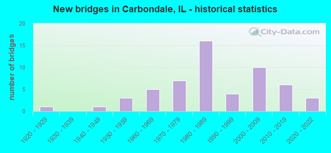
- New bridges - historical statistics
- 11920-1929
- 11940-1949
- 31950-1959
- 51960-1969
- 71970-1979
- 161980-1989
- 41990-1999
- 102000-2009
- 62010-2019
- 32020-2022
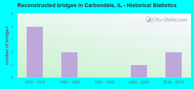
- Reconstructed bridges - Historical Statistics
- 41970-1979
- 21980-1989
- 01990-1999
- 12000-2009
- 22010-2019
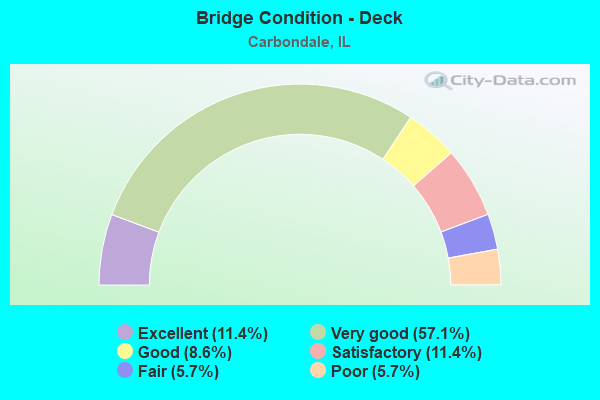
- Bridge Condition - Deck
- 11.4%Excellent
- 57.1%Very good
- 8.6%Good
- 11.4%Satisfactory
- 5.7%Fair
- 5.7%Poor
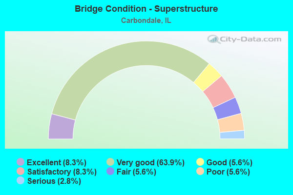
- Bridge Condition - Superstructure
- 8.3%Excellent
- 63.9%Very good
- 5.6%Good
- 8.3%Satisfactory
- 5.6%Fair
- 5.6%Poor
- 2.8%Serious
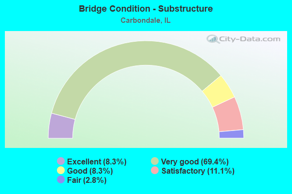
- Bridge Condition - Substructure
- 8.3%Excellent
- 69.4%Very good
- 8.3%Good
- 11.1%Satisfactory
- 2.8%Fair
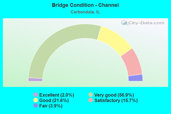
- Bridge Condition - Channel
- 2.0%Excellent
- 56.9%Very good
- 21.6%Good
- 15.7%Satisfactory
- 3.9%Fair
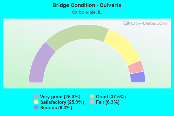
- Bridge Condition - Culverts
- 25.0%Very good
- 37.5%Good
- 25.0%Satisfactory
- 6.3%Fair
- 6.3%Serious
Find on map >> Show street view
Structure Number: 393271, Location: 0.06MI N OF FISHER (Lat: 37.738919, Lng: -89.214700), Route carried "on" structure: County highway , Year Built: 2010, Status: Open, Structure Length: 0.66m (2.17ft), Average Daily Traffic: 400 (year 2017), Truck Traffic: 9%, Average Future Daily Traffic: 819 (year 2032), Design Load: HS 20, Features Intersected: Trib to Crab Orchard, Facility Carried by Structure: CH-11 N Marion St
Minimum Vertical Clearance: 30+ m (98+ ft), Kilometerpoint: 0.097, Lanes on structure: 2, Owner: County Highway Agency, Approaching Roadway Width: 6.1m (20.0ft), Material/Design: Concrete, Design/Construction: Culvert, Number Of Spans In Main Unit: 2, Length of Maximum Span: 2.7m (8.9ft)
Condition: Channel: Very good, Culverts: Very good, Operating Rating: 71.0 metric tons, Method Used To Determine Operating Rating: Load Factor (LF) rating reported by rating factor (RF) method using MS18 loading, Inventory Rating: 42.4 metric tons, Method Used To Determine Inventory Rating: Load Factor (LF) rating reported by rating factor (RF) method using MS18 loading, Structural Evaluation: Equal to present desirable criteria, Waterway Adequacy: Equal to present desirable criteria, Approach Roadway Alignment: Equal to present desirable criteria, Designated Inspection Frequency: Every 48 months, Inspection Date: May 2018
Find on map >> Show street view
Structure Number: 393272, Location: 0.25 MI N OF C'DALE (Lat: 37.741889, Lng: -89.214442), Route carried "on" structure: County highway , Year Built: 2010, Status: Open, Structure Length: 0.71m (2.33ft), Average Daily Traffic: 400 (year 2017), Truck Traffic: 9%, Average Future Daily Traffic: 819 (year 2032), Design Load: HS 20, Features Intersected: Trib to Crab Orchard, Facility Carried by Structure: CH-11 N Marion St
Minimum Vertical Clearance: 30+ m (98+ ft), Kilometerpoint: 0.435, Lanes on structure: 2, Owner: County Highway Agency, Approaching Roadway Width: 6.1m (20.0ft), Material/Design: Concrete, Design/Construction: Culvert, Number Of Spans In Main Unit: 2, Length of Maximum Span: 3.3m (10.8ft)
Condition: Channel: Very good, Culverts: Very good, Operating Rating: 76.8 metric tons, Method Used To Determine Operating Rating: Load Factor (LF) rating reported by rating factor (RF) method using MS18 loading, Inventory Rating: 46.0 metric tons, Method Used To Determine Inventory Rating: Load Factor (LF) rating reported by rating factor (RF) method using MS18 loading, Structural Evaluation: Equal to present desirable criteria, Waterway Adequacy: Equal to present desirable criteria, Approach Roadway Alignment: Equal to present desirable criteria, Designated Inspection Frequency: Every 48 months, Inspection Date: May 2018
Find on map >> Show street view
Structure Number: 393274, Location: 1.25m E G City Rd (Lat: 37.672961, Lng: -89.162069), Route carried "on" structure: County highway , Year Built: 2012, Status: Open, Structure Length: 1.50m (4.92ft), Average Daily Traffic: 1,000 (year 2017), Truck Traffic: 5%, Average Future Daily Traffic: 710 (year 2032), Design Load: HS 25 or greater, Features Intersected: Trib. to Sycamore Cr, Facility Carried by Structure: E. Boskydell Road
Minimum Vertical Clearance: 30+ m (98+ ft), Kilometerpoint: 0.805, Lanes on structure: 2, Owner: County Highway Agency, Approaching Roadway Width: 6.7m (22.0ft), Skew: 2 degrees, Material/Design: Prestressed concrete, Design/Construction: Box Beam or Girders - Multiple, Number Of Spans In Main Unit: 1, Length of Maximum Span: 14.7m (48.2ft), Curb-To-Curb Width: 9.2m (30.2ft), Out-to-Out Width: 9.2m (30.2ft)
Condition: Deck: Very good, Superstructure: Very good, Substructure: Very good, Channel: Very good, Operating Rating: 55.1 metric tons, Method Used To Determine Operating Rating: Load Factor (LF) rating reported by rating factor (RF) method using MS18 loading, Inventory Rating: 42.4 metric tons, Method Used To Determine Inventory Rating: Load Factor (LF) rating reported by rating factor (RF) method using MS18 loading, Structural Evaluation: Equal to present desirable criteria, Deck Geometry: Equal to present minimum criteria, Waterway Adequacy: Equal to present desirable criteria, Approach Roadway Alignment: Equal to present desirable criteria, Designated Inspection Frequency: Every 48 months, Inspection Date: December 2018, Deck Structure Type: Concrete Precast Panels, Wearing Surface/Protective System: Wearing Surface: Gravel
Find on map >> Show street view
Structure Number: 395001, Location: N. LINE SEC. 35-9-1 (Lat: 37.700903, Lng: -89.183544), Route carried "on" structure: County highway , Year Built: 1960, Status: Open, Structure Length: 0.79m (2.59ft), Average Daily Traffic: 4,850 (year 2018), Truck Traffic: 4%, Average Future Daily Traffic: 6,770 (year 2032), Design Load: HS 20, Features Intersected: CREEK, Facility Carried by Structure: FAS 919
Minimum Vertical Clearance: 30+ m (98+ ft), Kilometerpoint: 0.032, Lanes on structure: 2, Owner: County Highway Agency, Approaching Roadway Width: 11.0m (36.1ft), Material/Design: Concrete, Design/Construction: Culvert, Number Of Spans In Main Unit: 2, Length of Maximum Span: 4.0m (13.1ft)
Condition: Channel: Very good, Culverts: Very good, Operating Rating: 60.6 metric tons, Method Used To Determine Operating Rating: Load Factor (LF) rating reported by rating factor (RF) method using MS18 loading, Inventory Rating: 36.3 metric tons, Method Used To Determine Inventory Rating: Load Factor (LF) rating reported by rating factor (RF) method using MS18 loading, Structural Evaluation: Equal to present desirable criteria, Waterway Adequacy: Equal to present desirable criteria, Approach Roadway Alignment: Equal to present desirable criteria, Designated Inspection Frequency: Every 24 months, Inspection Date: November 2020
Find on map >> Show street view
Structure Number: 395004, Location: 0.08 MI W OF US 51 S (Lat: 37.700419, Lng: -89.220239), Route carried "on" structure: Other road , Year Built: 1987, Status: Open, Structure Length: 0.79m (2.59ft), Average Daily Traffic: 1,700 (year 2020), Truck Traffic: 6%, Average Future Daily Traffic: 3,167 (year 2032), Design Load: HS 20, Features Intersected: PILES FORK CREEK, Facility Carried by Structure: RESERVOIR RD
Minimum Vertical Clearance: 30+ m (98+ ft), Kilometerpoint: 1.529, Lanes on structure: 2, Base Highway Network: Yes, Owner: City or Municipal Highway Agency, Approaching Roadway Width: 19.5m (64.0ft), Material/Design: Concrete, Design/Construction: Culvert, Number Of Spans In Main Unit: 2, Length of Maximum Span: 3.7m (12.1ft)
Condition: Channel: Very good, Culverts: Good, Operating Rating: 44.4 metric tons, Method Used To Determine Operating Rating: Assigned rating based on Load Factor Design (LFD) reported by rating factor (RF) using MS18 loading, Inventory Rating: 32.4 metric tons, Method Used To Determine Inventory Rating: Assigned rating based on Load Factor Design (LFD) reported by rating factor (RF) using MS18 loading, Structural Evaluation: Better than present minimum criteria, Waterway Adequacy: Equal to present desirable criteria, Approach Roadway Alignment: Equal to present desirable criteria, Designated Inspection Frequency: Every 48 months, Inspection Date: November 2020, Wearing Surface/Protective System: Wearing Surface: Bituminous
Find on map >> Show street view
Structure Number: 395005, Location: 1.5 MI S OLD IL 13 (Lat: 37.709489, Lng: -89.281981), Route carried "on" structure: County highway , Year Built: 1999, Status: Open, Structure Length: 0.98m (3.22ft), Average Daily Traffic: 650 (year 2017), Truck Traffic: 5%, Average Future Daily Traffic: 874 (year 2032), Design Load: HS 20, Features Intersected: TRIB TO MUD CREEK, Facility Carried by Structure: COUNTRY CLUB ROAD
Minimum Vertical Clearance: 30+ m (98+ ft), Kilometerpoint: 0.821, Lanes on structure: 2, Owner: Town or Township Highway Agency, Approaching Roadway Width: 6.1m (20.0ft), Skew: 3 degrees, Material/Design: Concrete, Design/Construction: Culvert, Number Of Spans In Main Unit: 3, Length of Maximum Span: 9.6m (31.5ft)
Condition: Channel: Very good, Culverts: Very good, Operating Rating: 53.8 metric tons, Method Used To Determine Operating Rating: Field evaluation and documented engineering judgment, Inventory Rating: 32.4 metric tons, Method Used To Determine Inventory Rating: Field evaluation and documented engineering judgment, Structural Evaluation: Equal to present desirable criteria, Waterway Adequacy: Equal to present desirable criteria, Approach Roadway Alignment: Equal to present desirable criteria, Designated Inspection Frequency: Every 48 months, Inspection Date: December 2018
Find on map >> Show street view
Structure Number: 396004, Location: CARBONDALE (Lat: 37.731800, Lng: -89.194497), Route carried "on" structure: City street , Year Built: 1984, Status: Open, Structure Length: 0.73m (2.40ft), Average Daily Traffic: 2,700 (year 2012), Truck Traffic: 5%, Average Future Daily Traffic: 3,058 (year 2032), Design Load: HS 20, Features Intersected: TRIB.PILES FORK CRK., Facility Carried by Structure: RENDLEMAN RD.
Minimum Vertical Clearance: 30+ m (98+ ft), Kilometerpoint: 0.451, Lanes on structure: 2, Owner: City or Municipal Highway Agency, Approaching Roadway Width: 8.2m (26.9ft), Material/Design: Concrete, Design/Construction: Culvert, Number Of Spans In Main Unit: 2, Length of Maximum Span: 3.4m (11.2ft)
Condition: Channel: Good, Culverts: Satisfactory, Operating Rating: 53.8 metric tons, Method Used To Determine Operating Rating: Field evaluation and documented engineering judgment, Inventory Rating: 32.4 metric tons, Method Used To Determine Inventory Rating: Field evaluation and documented engineering judgment, Structural Evaluation: Equal to present minimum criteria, Waterway Adequacy: Equal to present desirable criteria, Approach Roadway Alignment: Equal to present desirable criteria, Designated Inspection Frequency: Every 24 months, Inspection Date: November 2020
Find on map >> Show street view
Structure Number: 396014, Location: CARBONDALE (Lat: 37.726381, Lng: -89.246556), Route carried "on" structure: Other road , Year Built: 2020, Status: Open, Structure Length: 2.90m (9.51ft), Average Daily Traffic: 2,300 (year 2018), Truck Traffic: 3%, Average Future Daily Traffic: 3,112 (year 2032), Design Load: HS 25 or greater, Features Intersected: LITTLE CRAB ORCHARD, Facility Carried by Structure: SUNSET DR
Minimum Vertical Clearance: 30+ m (98+ ft), Kilometerpoint: 0.933, Lanes on structure: 2, Owner: City or Municipal Highway Agency, Approaching Roadway Width: 11.0m (36.1ft), Material/Design: Prestressed concrete, Design/Construction: Box Beam or Girders - Multiple, Number Of Spans In Main Unit: 3, Length of Maximum Span: 10.4m (34.1ft), Curb or Sidewalk Widths: Left: 1.5m (4.9ft), Right: 1.5m (4.9ft), Curb-To-Curb Width: 11.0m (36.1ft), Out-to-Out Width: 14.6m (47.9ft)
Condition: Deck: Excellent, Superstructure: Excellent, Substructure: Excellent, Channel: Excellent, Operating Rating: 64.5 metric tons, Method Used To Determine Operating Rating: Load and Resistance Factor Rating (LRFR) rating reported by rating factor(RF) method using HL-93 loadings, Inventory Rating: 50.2 metric tons, Method Used To Determine Inventory Rating: Load and Resistance Factor Rating (LRFR) rating reported by rating factor(RF) method using HL-93 loadings, Structural Evaluation: Superior to present desirable criteria, Deck Geometry: Somewhat better than minimum adequacy, Waterway Adequacy: Superior to present desirable criteria, Approach Roadway Alignment: Equal to present desirable criteria, Designated Inspection Frequency: Every 24 months, Inspection Date: Febuary 2021, Deck Structure Type: Concrete Cast-file-Place
Find on map >> Show street view
Structure Number: 3961, Location: WALL ST CARBONDALE (Lat: 37.715881, Lng: -89.208911), Route carried "on" structure: Other road , Year Built: 1962, Status: Open, Structure Length: 1.14m (3.74ft), Average Daily Traffic: 7,900 (year 2018), Truck Traffic: 3%, Average Future Daily Traffic: 14,305 (year 2032), Design Load: H 20, Features Intersected: PILES FORK, Facility Carried by Structure: WALL ST
Minimum Vertical Clearance: 30+ m (98+ ft), Kilometerpoint: 2.462, Lanes on structure: 4, Base Highway Network: Yes, Owner: City or Municipal Highway Agency, Approaching Roadway Width: 15.8m (51.8ft), Skew: 3 degrees, Material/Design: Concrete continuous, Design/Construction: Culvert, Number Of Spans In Main Unit: 2, Length of Maximum Span: 5.5m (18.0ft), Curb or Sidewalk Widths: Left: 3.7m (12.1ft), Right: 1.2m (3.9ft), Curb-To-Curb Width: 15.9m (52.2ft), Out-to-Out Width: 21.2m (69.6ft)
Condition: Channel: Satisfactory, Culverts: Satisfactory, Operating Rating: 42.1 metric tons, Method Used To Determine Operating Rating: Load Factor (LF) rating reported by rating factor (RF) method using MS18 loading, Inventory Rating: 25.3 metric tons, Method Used To Determine Inventory Rating: Load Factor (LF) rating reported by rating factor (RF) method using MS18 loading, Structural Evaluation: Equal to present minimum criteria, Deck Geometry: Meets minimum limits, Waterway Adequacy: Equal to present desirable criteria, Approach Roadway Alignment: Equal to present desirable criteria, Designated Inspection Frequency: Every 24 months, Inspection Date: November 2020, Wearing Surface/Protective System: Wearing Surface: Bituminous
Find on map >> Show street view
Structure Number: 396101, Location: CITY HALL CARBONDALE (Lat: 37.722247, Lng: -89.206339), Route carried "on" structure: City street , Year Built: 1971, Status: Open, Structure Length: 0.91m (2.99ft), Average Daily Traffic: 2,350 (year 2012), Truck Traffic: 5%, Average Future Daily Traffic: 3,003 (year 2032), Design Load: HS 20, Features Intersected: PILES FORK, Facility Carried by Structure: COLLEGE ST
Minimum Vertical Clearance: 30+ m (98+ ft), Kilometerpoint: 0.209, Lanes on structure: 2, Owner: City or Municipal Highway Agency, Approaching Roadway Width: 14.6m (47.9ft), Material/Design: Concrete continuous, Design/Construction: Culvert, Number Of Spans In Main Unit: 2, Length of Maximum Span: 4.3m (14.1ft), Curb or Sidewalk Widths: Left: 1.6m (5.2ft), Right: 2.6m (8.5ft), Curb-To-Curb Width: 10.4m (34.1ft), Out-to-Out Width: 14.8m (48.6ft)
Condition: Channel: Satisfactory, Culverts: Serious, Operating Rating: 51.5 metric tons, Method Used To Determine Operating Rating: Load Factor (LF) rating reported by rating factor (RF) method using MS18 loading, Inventory Rating: 30.8 metric tons, Method Used To Determine Inventory Rating: Load Factor (LF) rating reported by rating factor (RF) method using MS18 loading, Structural Evaluation: High priority of corrective action, Deck Geometry: Somewhat better than minimum adequacy, Waterway Adequacy: Equal to present desirable criteria, Approach Roadway Alignment: Equal to present desirable criteria, Designated Inspection Frequency: Every 24 months, Inspection Date: November 2020, Deck Structure Type: Concrete Cast-file-Place, Wearing Surface/Protective System: Wearing Surface: Bituminous
Find on map >> Show street view
Structure Number: 396102, Location: 1/4 MILE EAST RTE 51 (Lat: 37.700436, Lng: -89.213194), Route carried "on" structure: Other road , Year Built: 1982, Status: Open, Structure Length: 4.88m (16.01ft), Average Daily Traffic: 9,500 (year 2018), Truck Traffic: 3%, Average Future Daily Traffic: 9,500 (year 2032), Design Load: HS 20, Features Intersected: ICG RAILROAD, Facility Carried by Structure: PLEASANT HILL ROAD
Minimum Vertical Clearance: 30+ m (98+ ft), Kilometerpoint: 2.156, Lanes on structure: 4, Base Highway Network: Yes, Owner: City or Municipal Highway Agency, Approaching Roadway Width: 22.6m (74.1ft), Material/Design: Prestressed concrete continuous, Design/Construction: Stringer/Multi-beam, Number Of Spans In Main Unit: 3, Length of Maximum Span: 19.2m (63.0ft), Curb or Sidewalk Widths: Left: 2.0m (6.6ft), Right: 2.1m (6.9ft), Curb-To-Curb Width: 15.8m (51.8ft), Out-to-Out Width: 21.0m (68.9ft)
Condition: Deck: Good, Superstructure: Satisfactory, Substructure: Satisfactory, Operating Rating: 69.0 metric tons, Method Used To Determine Operating Rating: Load Factor (LF) rating reported by rating factor (RF) method using MS18 loading, Inventory Rating: 41.1 metric tons, Method Used To Determine Inventory Rating: Load Factor (LF) rating reported by rating factor (RF) method using MS18 loading, Structural Evaluation: Equal to present minimum criteria, Deck Geometry: Meets minimum limits, Underclear: Equal to present desirable criteria, Approach Roadway Alignment: Equal to present desirable criteria, Designated Inspection Frequency: Every 24 months, Inspection Date: November 2020, Deck Structure Type: Concrete Cast-file-Place
Find on map >> Show street view
Structure Number: 396103, Location: DORTHELLA CARBONDALE (Lat: 37.724925, Lng: -89.206086), Route carried "on" structure: City street , Year Built: 1964, Status: Open, Structure Length: 0.91m (2.99ft), Average Daily Traffic: 450 (year 2012), Truck Traffic: 4%, Average Future Daily Traffic: 601 (year 2032), Design Load: HS 20, Features Intersected: PILES FORK, Facility Carried by Structure: DORTHELLA ST
Minimum Vertical Clearance: 30+ m (98+ ft), Kilometerpoint: 0.113, Lanes on structure: 2, Owner: City or Municipal Highway Agency, Approaching Roadway Width: 11.6m (38.1ft), Material/Design: Concrete continuous, Design/Construction: Culvert, Number Of Spans In Main Unit: 2, Length of Maximum Span: 4.3m (14.1ft), Curb or Sidewalk Widths: Left: 1.2m (3.9ft), Right: 0.0m, Curb-To-Curb Width: 12.2m (40.0ft), Out-to-Out Width: 16.9m (55.4ft)
Condition: Channel: Satisfactory, Culverts: Good, Operating Rating: 50.2 metric tons, Method Used To Determine Operating Rating: Load Factor (LF) rating reported by rating factor (RF) method using MS18 loading, Inventory Rating: 30.1 metric tons, Method Used To Determine Inventory Rating: Load Factor (LF) rating reported by rating factor (RF) method using MS18 loading, Structural Evaluation: Better than present minimum criteria, Deck Geometry: Equal to present desirable criteria, Waterway Adequacy: Better than present minimum criteria, Approach Roadway Alignment: Equal to present desirable criteria, Designated Inspection Frequency: Every 24 months, Inspection Date: September 2021, Wearing Surface/Protective System: Wearing Surface: Bituminous
Find on map >> Show street view
Structure Number: 1003088, Location: 4 MI.SW CARTERVILLE (Lat: 37.714592, Lng: -89.151294), Route carried "on" structure: County highway , Year Built: 1976, Status: Open, Structure Length: 5.22m (17.13ft), Average Daily Traffic: 1,300 (year 2021), Truck Traffic: 8%, Average Future Daily Traffic: 1,886 (year 2032), Design Load: HS 20, Features Intersected: CRAB ORCHARD SPILWAY, Facility Carried by Structure: FAS 1901
Minimum Vertical Clearance: 30+ m (98+ ft), Kilometerpoint: 3.492, Lanes on structure: 2, Owner: County Highway Agency, Approaching Roadway Width: 7.9m (25.9ft), Material/Design: Prestressed concrete, Design/Construction: Box Beam or Girders - Multiple, Number Of Spans In Main Unit: 3, Length of Maximum Span: 17.9m (58.7ft), Curb-To-Curb Width: 9.0m (29.5ft), Out-to-Out Width: 10.1m (33.1ft)
Condition: Deck: Satisfactory, Superstructure: Satisfactory, Substructure: Very good, Channel: Good, Operating Rating: 77.4 metric tons, Method Used To Determine Operating Rating: Load Factor (LF) rating reported by rating factor (RF) method using MS18 loading, Inventory Rating: 46.3 metric tons, Method Used To Determine Inventory Rating: Load Factor (LF) rating reported by rating factor (RF) method using MS18 loading, Structural Evaluation: Equal to present minimum criteria, Deck Geometry: Somewhat better than minimum adequacy, Waterway Adequacy: Better than present minimum criteria, Approach Roadway Alignment: Somewhat better than minimum adequacy, Designated Inspection Frequency: Every 24 months, Inspection Date: April 2021, Deck Structure Type: Concrete Precast Panels, Wearing Surface/Protective System: Wearing Surface: Bituminous
Find on map >> Show street view
Structure Number: 393097, Location: N LINE SEC 2-9-1 (Lat: 37.772611, Lng: -89.178711), Route carried "under" structure: County highway , Year Built: 1968, Structure Length: 0. m, Average Daily Traffic: 10 (year 2017), Features Intersected: C. ORCHARD CK-TR 362, Facility Carried by Structure: CH 11
Minimum Vertical Clearance: 4.57m (14.99ft), Kilometerpoint: 0.161, Lanes on structure: 2, Lanes under structure: 1, Material/Design: Prestressed concrete, Design/Construction: Box Beam or Girders - Multiple, Length of Maximum Span: 17.4m (57.1ft)
Find on map >> Show street view
Structure Number: 39993, Location: CARBONDALE AT SIU (Lat: 37.715011, Lng: -89.215208), Route carried "under" structure: US 51, Year Built: 1970, Structure Length: 0. m, Average Daily Traffic: 13,900 (year 2021), Truck Traffic: 7%, Features Intersected: US 51 - FAP 718, Facility Carried by Structure: SIU PED OVERHEAD(N
Minimum Vertical Clearance: 5.64m (18.50ft), Kilometerpoint: 87.385, Lanes under structure: 2, Material/Design: Concrete, Design/Construction: Tee Beam, Length of Maximum Span: 21.6m (70.9ft)
Find on map >> Show street view
Structure Number: 399931, Location: CARBONDALE SIU (Lat: 37.712219, Lng: -89.214797), Route carried "under" structure: US 51, Year Built: 1988, Structure Length: 0. m, Average Daily Traffic: 8,450 (year 2021), Truck Traffic: 7%, Features Intersected: US 51-FAP 718, Facility Carried by Structure: SO. SIU PED OVERPA
Minimum Vertical Clearance: 5.79m (19.00ft), Kilometerpoint: 87.111, Lanes under structure: 2, Material/Design: Prestressed concrete, Design/Construction: Stringer/Multi-beam, Length of Maximum Span: 28.7m (94.2ft)
Find on map >> Show street view
Structure Number: 399932, Location: E OF US 51 NB-CDALE (Lat: 37.719981, Lng: -89.215250), Route carried "under" structure: Other road , Year Built: 2000, Structure Length: 0. m, Average Daily Traffic: 4,550 (year 2018), Truck Traffic: 4%, Features Intersected: MILL STREET, Facility Carried by Structure: CN/ICG RR
Minimum Vertical Clearance: 5.11m (16.77ft), Kilometerpoint: 1.110, Lanes under structure: 4, Material/Design: Prestressed concrete, Design/Construction: Box Beam or Girders - Multiple, Length of Maximum Span: 14.1m (46.3ft)