Bridge Statistics for Camden, New Jersey (NJ)
Condition, Traffic, Stress, Structural Evaluation, Project Costs
- National Bridge Inventory (NBI) Statistics
- 88Number of bridges
- 3,494ft / 1,065mTotal length
- $163,079,000Total costs
- 2,853,316Total average daily traffic
- 196,626Total average daily truck traffic
- National Bridge Inventory (NBI) Registered Bridges for Camden
- No street view available for this location
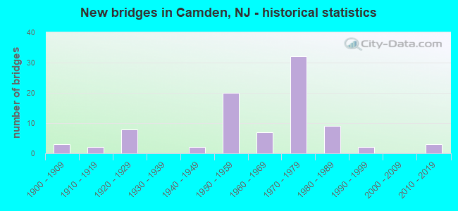
- New bridges - historical statistics
- 31900-1909
- 21910-1919
- 81920-1929
- 21940-1949
- 201950-1959
- 71960-1969
- 321970-1979
- 91980-1989
- 21990-1999
- 32010-2019
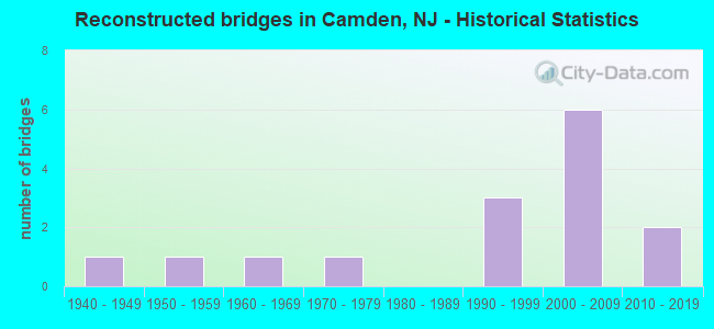
- Reconstructed bridges - Historical Statistics
- 11940-1949
- 11950-1959
- 11960-1969
- 11970-1979
- 01980-1989
- 31990-1999
- 62000-2009
- 22010-2019
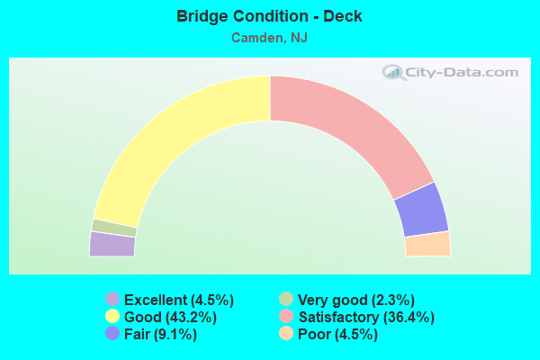
- Bridge Condition - Deck
- 4.5%Excellent
- 2.3%Very good
- 43.2%Good
- 36.4%Satisfactory
- 9.1%Fair
- 4.5%Poor
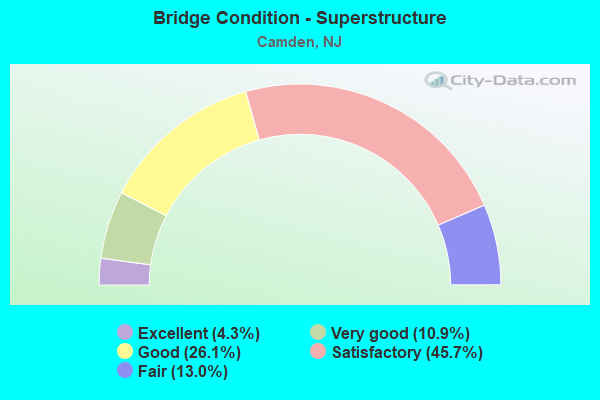
- Bridge Condition - Superstructure
- 4.3%Excellent
- 10.9%Very good
- 26.1%Good
- 45.7%Satisfactory
- 13.0%Fair
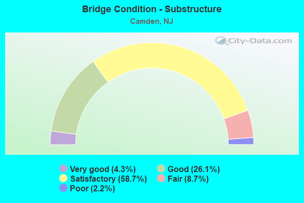
- Bridge Condition - Substructure
- 4.3%Very good
- 26.1%Good
- 58.7%Satisfactory
- 8.7%Fair
- 2.2%Poor
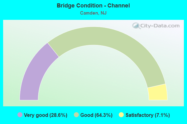
- Bridge Condition - Channel
- 28.6%Very good
- 64.3%Good
- 7.1%Satisfactory
Find on map >> Show street view
Structure Number: 45516, Location: 0.34 mi South of CR603 (Lat: 39.916931, Lng: -75.119739), Route carried "on" structure: County highway 551, Year Built: 1904, Year Reconstructed: 1945, Status: Open, Structure Length: 3.69m (12.11ft), Average Daily Traffic: 3,868 (year 2021), Truck Traffic: 4%, Average Future Daily Traffic: 4,720 (year 2041), Features Intersected: VINELAND SECONDARY
Minimum Vertical Clearance: 30+ m (98+ ft), Kilometerpoint: 52.288, Lanes on structure: 2, Lanes under structure: 2, Base Highway Network: Yes, Maintenance Responsibility: State Highway Agency, Approaching Roadway Width: 15.8m (51.8ft), Material/Design: Concrete continuous, Design/Construction: Frame, Number Of Spans In Main Unit: 5, Length of Maximum Span: 9.8m (32.2ft), Curb or Sidewalk Widths: Left: 1.8m (5.9ft), Right: 1.8m (5.9ft), Curb-To-Curb Width: 15.8m (51.8ft), Out-to-Out Width: 20.5m (67.3ft)
Condition: Superstructure: Fair, Substructure: Fair, Inventory Rating: 68.9 metric tons, Method Used To Determine Inventory Rating: Load Factor (LF), Structural Evaluation: Somewhat better than minimum adequacy, Deck Geometry: Superior to present desirable criteria, Underclear: High priority of replacement, Approach Roadway Alignment: Equal to present minimum criteria, Length Of Structure Improvement: 4.57m (14.99ft), Designated Inspection Frequency: Every 24 months, Inspection Date: September 2021, Bridge Improvement Cost: $3,148,000, Roadway Improvement Cost: $3,678,000, Total Project Cost: $6,253,000 ( Estimate for 2021)
Find on map >> Show street view
Structure Number: 4500001, Location: 2 MILES WEST OF US 130 (Lat: 39.842311, Lng: -75.384931), Route carried "on" structure: US 322, Year Built: 1974, Status: Open, Structure Length: 424.13m (1391.50ft), Average Daily Traffic: 39,131 (year 2012), Truck Traffic: 7%, Average Future Daily Traffic: 47,747 (year 2032), Design Load: HS 20+Mod, Features Intersected: DELAWARE RIVER
Minimum Vertical Clearance: 4.46m (14.63ft), Kilometerpoint: 0.000, Lanes on structure: 5, Lanes under structure: 2, Base Highway Network: Yes, Toll: Toll bridge, Owner: Local Toll Authority, Approaching Roadway Width: 18.3m (60.0ft), Navigation Control: Yes ( Vertical Clearance: 56.7m (186.0ft), Horizontal Clearance: 243.8m (799.9ft)), Material/Design: Steel, Design/Construction: Truss - Thru, Number Of Spans In Main Unit: 3, Number Of Approach Spans: 74, Length of Maximum Span: 501.1m (1,644.0ft), Curb or Sidewalk Widths: Left: 0.8m (2.6ft), Right: 0.8m (2.6ft), Curb-To-Curb Width: 18.3m (60.0ft), Out-to-Out Width: 20.8m (68.2ft)
Condition: Deck: Satisfactory, Superstructure: Satisfactory, Substructure: Satisfactory, Channel: Very good, Operating Rating: 49.9 metric tons, Method Used To Determine Operating Rating: Load Factor (LF), Inventory Rating: 29.9 metric tons, Method Used To Determine Inventory Rating: Load Factor (LF), Structural Evaluation: Equal to present minimum criteria, Deck Geometry: High priority of replacement, Underclear: Somewhat better than minimum adequacy, Waterway Adequacy: Superior to present desirable criteria, Approach Roadway Alignment: Equal to present desirable criteria, Length Of Structure Improvement: 424.10m (1391.40ft), Designated Inspection Frequency: Every 24 months, Critical Feature Inspection Frequency: Every 24 months, Underwater Inspection Frequency: Every 48 months, Inspection Date: May 2020, Critical Feature Inspection Date: May 2020, Underwater Inspection Date: June 2020, Bridge Improvement Cost: $88,128,000, Roadway Improvement Cost: $200,000, Total Project Cost: $106,000,000 ( Estimate for 2020), Deck Structure Type: Concrete Cast-file-Place, Wearing Surface/Protective System: Wearing Surface: Monolithic Concrete
Find on map >> Show street view
Structure Number: 4500004, Location: 1.0 MI E OF WW BRIDGE (Lat: 39.901600, Lng: -75.110569), Route carried "on" structure: Ramp Interstate 76, Year Built: 1957, Status: Open, Structure Length: 28.35m (93.01ft), Average Daily Traffic: 7,900 (year 2020), Truck Traffic: 9%, Average Future Daily Traffic: 8,700 (year 2040), Design Load: HS 20, Features Intersected: I-676, Facility Carried by Structure: RAMP BW
Minimum Vertical Clearance: 30+ m (98+ ft), Kilometerpoint: 1.674, Lanes on structure: 2, Lanes under structure: 8, Base Highway Network: Yes, Toll: On toll road, Owner: Local Toll Authority, Approaching Roadway Width: 15.2m (49.9ft), Skew: 9 degrees, Material/Design: Steel, Design/Construction: Stringer/Multi-beam, Number Of Spans In Main Unit: 13, Length of Maximum Span: 30.5m (100.1ft), Curb or Sidewalk Widths: Left: 0.9m (3.0ft), Right: 0.9m (3.0ft), Curb-To-Curb Width: 11.6m (38.1ft), Out-to-Out Width: 14.0m (45.9ft)
Condition: Deck: Good, Superstructure: Satisfactory, Substructure: Satisfactory, Operating Rating: 89.8 metric tons, Method Used To Determine Operating Rating: Load Factor (LF), Inventory Rating: 54.4 metric tons, Method Used To Determine Inventory Rating: Load Factor (LF), Structural Evaluation: Equal to present minimum criteria, Deck Geometry: Superior to present desirable criteria, Underclear: High priority of corrective action, Approach Roadway Alignment: Equal to present minimum criteria, Designated Inspection Frequency: Every 24 months, Inspection Date: June 2020, Deck Structure Type: Concrete Cast-file-Place, Wearing Surface/Protective System: Wearing Surface: Monolithic Concrete, Deck Protection: Galvanized Reinforcing
Find on map >> Show street view
Structure Number: 4500005, Location: 2.75 MI E OF WW BRIDGE (Lat: 39.901219, Lng: -75.098219), Route carried "on" structure: Ramp Interstate 76, Year Built: 1957, Status: Open, Structure Length: 5.36m (17.59ft), Average Daily Traffic: 15,830 (year 2020), Truck Traffic: 9%, Average Future Daily Traffic: 19,315 (year 2040), Design Load: HS 20, Features Intersected: CRESCENT BLVD (US 130), Facility Carried by Structure: RAMPS BE-BW
Minimum Vertical Clearance: 30+ m (98+ ft), Kilometerpoint: 0.595, Lanes on structure: 5, Lanes under structure: 6, Base Highway Network: Yes (Inventory Route: 76, Subroute: 37), Toll: On toll road, Owner: Local Toll Authority, Approaching Roadway Width: 24.4m (80.1ft), Skew: 22 degrees, Material/Design: Steel, Design/Construction: Stringer/Multi-beam, Number Of Spans In Main Unit: 3, Length of Maximum Span: 27.1m (88.9ft), Curb or Sidewalk Widths: Left: 0.6m (2.0ft), Right: 0.6m (2.0ft), Curb-To-Curb Width: 24.4m (80.1ft), Out-to-Out Width: 27.6m (90.6ft)
Condition: Deck: Good, Superstructure: Satisfactory, Substructure: Satisfactory, Operating Rating: 89.8 metric tons, Method Used To Determine Operating Rating: Load Factor (LF), Inventory Rating: 58.1 metric tons, Method Used To Determine Inventory Rating: Load Factor (LF), Structural Evaluation: Equal to present minimum criteria, Deck Geometry: Superior to present desirable criteria, Underclear: Meets minimum limits, Approach Roadway Alignment: Equal to present minimum criteria, Designated Inspection Frequency: Every 24 months, Inspection Date: June 2020, Deck Structure Type: Concrete Cast-file-Place, Wearing Surface/Protective System: Wearing Surface: Monolithic Concrete, Deck Protection: Galvanized Reinforcing
Find on map >> Show street view
Structure Number: 4500007, Location: 0.75 MI E OF WW BRIDGE (Lat: 39.902600, Lng: -75.112150), Route carried "on" structure: Ramp Interstate 76, Year Built: 1957, Status: Open, Structure Length: 5.39m (17.68ft), Average Daily Traffic: 2,800 (year 2020), Truck Traffic: 9%, Average Future Daily Traffic: 3,100 (year 2040), Design Load: HS 20, Features Intersected: COLLINGS AVENUE (CR 630), Facility Carried by Structure: RAMP FB
Minimum Vertical Clearance: 30+ m (98+ ft), Kilometerpoint: 1.674, Lanes on structure: 1, Lanes under structure: 2, Base Highway Network: Yes, Toll: On toll road, Owner: Local Toll Authority, Approaching Roadway Width: 7.6m (24.9ft), Skew: 9 degrees, Material/Design: Steel, Design/Construction: Stringer/Multi-beam, Number Of Spans In Main Unit: 4, Length of Maximum Span: 21.6m (70.9ft), Curb or Sidewalk Widths: Left: 0.9m (3.0ft), Right: 0.9m (3.0ft), Curb-To-Curb Width: 7.3m (24.0ft), Out-to-Out Width: 10.4m (34.1ft)
Condition: Deck: Good, Superstructure: Good, Substructure: Good, Operating Rating: 89.8 metric tons, Method Used To Determine Operating Rating: Load Factor (LF), Inventory Rating: 61.7 metric tons, Method Used To Determine Inventory Rating: Load Factor (LF), Structural Evaluation: Better than present minimum criteria, Deck Geometry: Better than present minimum criteria, Underclear: Equal to present minimum criteria, Approach Roadway Alignment: Equal to present minimum criteria, Designated Inspection Frequency: Every 24 months, Inspection Date: June 2020, Deck Structure Type: Concrete Cast-file-Place, Wearing Surface/Protective System: Wearing Surface: Monolithic Concrete, Deck Protection: Galvanized Reinforcing
Find on map >> Show street view
Structure Number: 4500008, Location: 0.75 MI E OF WW BRIDGE (Lat: 39.902731, Lng: -75.115661), Route carried "on" structure: Ramp Interstate 76, Year Built: 1957, Status: Open, Structure Length: 57.73m (189.40ft), Average Daily Traffic: 8,065 (year 2020), Truck Traffic: 9%, Average Future Daily Traffic: 8,900 (year 2040), Design Load: HS 20, Features Intersected: I-76 & I-676, Facility Carried by Structure: RAMP BE
Minimum Vertical Clearance: 4.82m (15.81ft), Kilometerpoint: 1.674, Lanes on structure: 3, Lanes under structure: 13, Base Highway Network: Yes, Toll: On toll road, Owner: Local Toll Authority, Approaching Roadway Width: 11.0m (36.1ft), Skew: 9 degrees, Material/Design: Steel, Design/Construction: Stringer/Multi-beam, Number Of Spans In Main Unit: 23, Length of Maximum Span: 39.0m (128.0ft), Curb or Sidewalk Widths: Left: 0.9m (3.0ft), Right: 0.9m (3.0ft), Curb-To-Curb Width: 11.0m (36.1ft), Out-to-Out Width: 14.9m (48.9ft)
Condition: Deck: Good, Superstructure: Satisfactory, Substructure: Good, Operating Rating: 89.8 metric tons, Method Used To Determine Operating Rating: Load Factor (LF), Inventory Rating: 59.0 metric tons, Method Used To Determine Inventory Rating: Load Factor (LF), Structural Evaluation: Equal to present minimum criteria, Deck Geometry: High priority of replacement, Underclear: Somewhat better than minimum adequacy, Approach Roadway Alignment: Equal to present minimum criteria, Designated Inspection Frequency: Every 24 months, Inspection Date: June 2020, Deck Structure Type: Concrete Cast-file-Place, Wearing Surface/Protective System: Wearing Surface: Monolithic Concrete, Deck Protection: Galvanized Reinforcing
Find on map >> Show street view
Structure Number: 450001, Location: CITY OF CAMDEN (Lat: 39.953761, Lng: -75.140681), Route carried "on" structure: Interstate 676, Year Built: 1926, Year Reconstructed: 1984, Status: Open, Structure Length: 249.02m (816.99ft), Average Daily Traffic: 104,658 (year 2020), Truck Traffic: 4%, Average Future Daily Traffic: 127,703 (year 2040), Features Intersected: DEL RIV,I-95,RR&ROADS
Minimum Vertical Clearance: 5.13m (16.83ft), Kilometerpoint: 7.355, Lanes on structure: 7, Lanes under structure: 28, Toll: Toll bridge, Owner: Local Toll Authority, Approaching Roadway Width: 32.9m (107.9ft), Skew: 30 degrees, Navigation Control: Yes ( Vertical Clearance: 39.3m (128.9ft), Horizontal Clearance: 243.8m (799.9ft)), Material/Design: Steel, Design/Construction: Suspension, Number Of Spans In Main Unit: 3, Number Of Approach Spans: 87, Length of Maximum Span: 533.4m (1,750.0ft), Curb or Sidewalk Widths: Left: 2.9m (9.5ft), Right: 2.9m (9.5ft), Curb-To-Curb Width: 23.7m (77.8ft), Out-to-Out Width: 25.0m (82.0ft)
Condition: Deck: Good, Superstructure: Satisfactory, Substructure: Fair, Channel: Very good, Operating Rating: 32.7 metric tons, Method Used To Determine Operating Rating: Allowable Stress (AS), Inventory Rating: 20.0 metric tons, Method Used To Determine Inventory Rating: Allowable Stress (AS), Structural Evaluation: Somewhat better than minimum adequacy, Deck Geometry: High priority of replacement, Underclear: High priority of corrective action, Waterway Adequacy: Superior to present desirable criteria, Approach Roadway Alignment: Somewhat better than minimum adequacy, Length Of Structure Improvement: 252.80m (829.40ft), Designated Inspection Frequency: Every 24 months, Critical Feature Inspection Frequency: Every 24 months, Underwater Inspection Frequency: Every 48 months, Inspection Date: May 2020, Critical Feature Inspection Date: May 2020, Underwater Inspection Date: June 2020, Bridge Improvement Cost: $1,932,000, Roadway Improvement Cost: $5,693,000, Total Project Cost: $26,095,000 ( Estimate for 2040), Deck Structure Type: Steel plate, Wearing Surface/Protective System: Wearing Surface: Bituminous
Find on map >> Show street view
Structure Number: 406156, Location: 0.63 MI S OF 30-537 JCT (Lat: 39.938761, Lng: -75.093111), Route carried "under" structure: US 30, Year Built: 1949, Structure Length: 0. m, Average Daily Traffic: 87,080 (year 2020), Truck Traffic: 4%, Features Intersected: US 30, Facility Carried by Structure: BAIRD BLVD(CO 608)
Minimum Vertical Clearance: 4.21m (13.81ft), Kilometerpoint: 4.007, Lanes on structure: 2, Lanes under structure: 8, Material/Design: Steel, Design/Construction: Girder and Floorbeam System, Length of Maximum Span: 40.2m (131.9ft)
Find on map >> Show street view
Structure Number: 406159, Location: 0.6 MI.E.BEN FRANKLIN BR. (Lat: 39.943331, Lng: -75.106669), Route carried "under" structure: Ramp US 30, Year Built: 1925, Structure Length: 0. m, Average Daily Traffic: 3,513 (year 2021), Truck Traffic: 1%, Features Intersected: US RTE 30,SERVICE ROADS, Facility Carried by Structure: FEDERALST (RT 537)
Minimum Vertical Clearance: 4.44m (14.57ft), Kilometerpoint: 2.575, Lanes on structure: 2, Lanes under structure: 1, Material/Design: Steel, Design/Construction: Girder and Floorbeam System, Length of Maximum Span: 29.0m (95.1ft)
Find on map >> Show street view
Structure Number: 406159, Location: 0.6 MI.E.BEN FRANKLIN BR. (Lat: 39.943331, Lng: -75.106669), Route carried "under" structure: ServiceCity street , Year Built: 1925, Structure Length: 0. m, Average Daily Traffic: 3,513 (year 2021), Truck Traffic: 1%, Features Intersected: US RTE 30,SERVICE ROADS, Facility Carried by Structure: FEDERALST (RT 537)
Minimum Vertical Clearance: 4.47m (14.67ft), Kilometerpoint: 0.000, Lanes on structure: 2, Lanes under structure: 1, Material/Design: Steel, Design/Construction: Girder and Floorbeam System, Length of Maximum Span: 29.0m (95.1ft)
Find on map >> Show street view
Structure Number: 406159, Location: 0.6 MI.E.BEN FRANKLIN BR. (Lat: 39.943331, Lng: -75.106669), Route carried "under" structure: US 30, Year Built: 1925, Structure Length: 0. m, Average Daily Traffic: 94,272 (year 2021), Truck Traffic: 4%, Features Intersected: US RTE 30,SERVICE ROADS, Facility Carried by Structure: FEDERALST (RT 537)
Minimum Vertical Clearance: 4.32m (14.17ft), Kilometerpoint: 2.575, Lanes on structure: 2, Lanes under structure: 6, Material/Design: Steel, Design/Construction: Girder and Floorbeam System, Length of Maximum Span: 29.0m (95.1ft)
Find on map >> Show street view
Structure Number: 406161, Location: 0.15 MI S OF CO 537 (Lat: 39.942000, Lng: -75.105769), Route carried "under" structure: US 30, Year Built: 1951, Structure Length: 0. m, Average Daily Traffic: 95,860 (year 2020), Truck Traffic: 4%, Features Intersected: US 30, Facility Carried by Structure: FLANDERS AVENUE
Minimum Vertical Clearance: 4.67m (15.32ft), Kilometerpoint: 2.816, Lanes on structure: 3, Lanes under structure: 8, Material/Design: Steel, Design/Construction: Stringer/Multi-beam, Length of Maximum Span: 24.4m (80.1ft)
Find on map >> Show street view
Structure Number: 41815, Location: AT I-676 & I-76 JCT (Lat: 39.902089, Lng: -75.111431), Route carried "under" structure: Interstate 676, Year Built: 1954, Structure Length: 0. m, Average Daily Traffic: 32,295 (year 2021), Truck Traffic: 9%, Features Intersected: I-676NB, Facility Carried by Structure: CR 630
Minimum Vertical Clearance: 4.90m (16.08ft), Kilometerpoint: 0.579, Lanes on structure: 2, Lanes under structure: 4, Material/Design: Steel, Design/Construction: Stringer/Multi-beam, Length of Maximum Span: 21.6m (70.9ft)
Find on map >> Show street view
Structure Number: 418151, Location: .2MI NORTH OF NEWTON CR (Lat: 39.902500, Lng: -75.113061), Route carried "under" structure: Interstate 676, Year Built: 1954, Structure Length: 0. m, Average Daily Traffic: 32,290 (year 2021), Truck Traffic: 9%, Features Intersected: I-676 SB, Facility Carried by Structure: CR 630
Minimum Vertical Clearance: 4.80m (15.75ft), Kilometerpoint: 0.579, Lanes on structure: 2, Lanes under structure: 4, Material/Design: Steel, Design/Construction: Stringer/Multi-beam, Length of Maximum Span: 27.1m (88.9ft)
Find on map >> Show street view
Structure Number: 418155, Location: 1.14 MI NORTH OF I-76 JCT (Lat: 39.912389, Lng: -75.115639), Route carried "under" structure: City street , Year Built: 1980, Structure Length: 0. m, Average Daily Traffic: 7,502 (year 2020), Truck Traffic: 4%, Features Intersected: MORGAN BLVD., Facility Carried by Structure: I-676
Minimum Vertical Clearance: 5.21m (17.09ft), Kilometerpoint: 0.338, Lanes on structure: 8, Lanes under structure: 6, Material/Design: Steel, Design/Construction: Stringer/Multi-beam, Length of Maximum Span: 32.0m (105.0ft)
Find on map >> Show street view
Structure Number: 418156, Location: 1.51 M NORTH OF I-76 (Lat: 39.916731, Lng: -75.116169), Route carried "under" structure: City street , Year Built: 1980, Structure Length: 0. m, Average Daily Traffic: 1,726 (year 2020), Truck Traffic: 3%, Features Intersected: CHELTON AVENUE & CONRAIL, Facility Carried by Structure: I-676
Minimum Vertical Clearance: 7.09m (23.26ft), Kilometerpoint: 0.435, Lanes on structure: 6, Lanes under structure: 2, Material/Design: Steel, Design/Construction: Stringer/Multi-beam, Length of Maximum Span: 39.9m (130.9ft)
Find on map >> Show street view
Structure Number: 418157, Location: 1.73 MILES N OF I-76 JCT (Lat: 39.921161, Lng: -75.116039), Route carried "under" structure: County highway 603, Year Built: 1980, Structure Length: 0. m, Average Daily Traffic: 4,381 (year 2020), Truck Traffic: 4%, Features Intersected: FERRY AVENUE (CR 603), Facility Carried by Structure: I-676
Minimum Vertical Clearance: 4.88m (16.01ft), Kilometerpoint: 1.287, Lanes on structure: 6, Lanes under structure: 2, Material/Design: Steel, Design/Construction: Stringer/Multi-beam, Length of Maximum Span: 22.6m (74.1ft)
Find on map >> Show street view
Structure Number: 418158, Location: 1.87 MILES NORTH OF I-76 (Lat: 39.923361, Lng: -75.115939), Route carried "under" structure: City street , Year Built: 1980, Structure Length: 0. m, Average Daily Traffic: 3,225 (year 2020), Truck Traffic: 3%, Features Intersected: CARL MILLER BLVD, Facility Carried by Structure: I-676
Minimum Vertical Clearance: 4.80m (15.75ft), Kilometerpoint: 0.966, Lanes on structure: 6, Lanes under structure: 2, Material/Design: Steel, Design/Construction: Stringer/Multi-beam, Length of Maximum Span: 15.8m (51.8ft)
Find on map >> Show street view
Structure Number: 41816, Location: 1.23 MILES SOUTH OF US 30 (Lat: 39.928969, Lng: -75.115100), Route carried "under" structure: City street , Year Built: 1971, Structure Length: 0. m, Average Daily Traffic: 7,047 (year 2020), Truck Traffic: 3%, Features Intersected: ATLANTIC AVENUE, Facility Carried by Structure: I-676
Minimum Vertical Clearance: 4.57m (14.99ft), Kilometerpoint: 1.143, Lanes on structure: 7, Lanes under structure: 3, Material/Design: Steel, Design/Construction: Stringer/Multi-beam, Length of Maximum Span: 25.0m (82.0ft)
Find on map >> Show street view
Structure Number: 418161, Location: 1MI SOUTH OF RT 30 (Lat: 39.930981, Lng: -75.113500), Route carried "under" structure: County highway 607, Year Built: 1971, Structure Length: 0. m, Average Daily Traffic: 3,300 (year 2021), Truck Traffic: 4%, Features Intersected: CITY STS,RAMP TO KAIGHNS, Facility Carried by Structure: I-676
Minimum Vertical Clearance: 4.42m (14.50ft), Kilometerpoint: 2.543, Lanes on structure: 6, Lanes under structure: 2, Material/Design: Steel continuous, Design/Construction: Girder and Floorbeam System, Length of Maximum Span: 42.1m (138.1ft)
Find on map >> Show street view
Structure Number: 418161, Location: 1MI SOUTH OF RT 30 (Lat: 39.930981, Lng: -75.113500), Route carried "under" structure: Ramp Interstate 676, Year Built: 1971, Structure Length: 0. m, Average Daily Traffic: 3,280 (year 2021), Truck Traffic: 3%, Features Intersected: CITY STS,RAMP TO KAIGHNS
Minimum Vertical Clearance: 5.36m (17.59ft), Kilometerpoint: 2.478, Lanes on structure: 6, Lanes under structure: 1, Material/Design: Steel continuous, Design/Construction: Girder and Floorbeam System, Length of Maximum Span: 42.1m (138.1ft)
Find on map >> Show street view
Structure Number: 418161, Location: 1MI SOUTH OF RT 30 (Lat: 39.930981, Lng: -75.113500), Route carried "under" structure: City street , Year Built: 1971, Structure Length: 0. m, Average Daily Traffic: 3,300 (year 2021), Truck Traffic: 3%, Features Intersected: CITY STS,RAMP TO KAIGHNS, Facility Carried by Structure: I-676
Minimum Vertical Clearance: 4.63m (15.19ft), Kilometerpoint: 0.000, Lanes on structure: 6, Lanes under structure: 2, Material/Design: Steel continuous, Design/Construction: Girder and Floorbeam System, Length of Maximum Span: 42.1m (138.1ft)
Find on map >> Show street view
Structure Number: 418161, Location: 1MI SOUTH OF RT 30 (Lat: 39.930981, Lng: -75.113500), Route carried "under" structure: City street , Year Built: 1971, Structure Length: 0. m, Average Daily Traffic: 3,300 (year 2021), Truck Traffic: 3%, Features Intersected: CITY STS,RAMP TO KAIGHNS, Facility Carried by Structure: I-676
Minimum Vertical Clearance: 5.58m (18.31ft), Kilometerpoint: 0.000, Lanes on structure: 6, Lanes under structure: 1, Material/Design: Steel continuous, Design/Construction: Girder and Floorbeam System, Length of Maximum Span: 42.1m (138.1ft)
Find on map >> Show street view
Structure Number: 418161, Location: 1MI SOUTH OF RT 30 (Lat: 39.930981, Lng: -75.113500), Route carried "under" structure: City street , Year Built: 1971, Structure Length: 0. m, Average Daily Traffic: 3,100 (year 2021), Truck Traffic: 3%, Features Intersected: CITY STS,RAMP TO KAIGHNS, Facility Carried by Structure: I-676
Minimum Vertical Clearance: 4.72m (15.49ft), Kilometerpoint: 0.692, Lanes on structure: 6, Lanes under structure: 1, Material/Design: Steel continuous, Design/Construction: Girder and Floorbeam System, Length of Maximum Span: 42.1m (138.1ft)
Find on map >> Show street view
Structure Number: 418161, Location: 1MI SOUTH OF RT 30 (Lat: 39.930981, Lng: -75.113500), Route carried "under" structure: City street , Year Built: 1971, Structure Length: 0. m, Average Daily Traffic: 3,200 (year 2021), Truck Traffic: 3%, Features Intersected: CITY STS,RAMP TO KAIGHNS, Facility Carried by Structure: I-676
Minimum Vertical Clearance: 5.26m (17.26ft), Kilometerpoint: 1.191, Lanes on structure: 6, Lanes under structure: 2, Material/Design: Steel continuous, Design/Construction: Girder and Floorbeam System, Length of Maximum Span: 42.1m (138.1ft)
Find on map >> Show street view
Structure Number: 43015, Location: .62 MI SOUTH OF US 30 (Lat: 39.936961, Lng: -75.111711), Route carried "under" structure: City street , Year Built: 1971, Structure Length: 0. m, Average Daily Traffic: 4,855 (year 2020), Truck Traffic: 3%, Features Intersected: PINE STREET, Facility Carried by Structure: I-676
Minimum Vertical Clearance: 4.57m (14.99ft), Kilometerpoint: 0.000, Lanes on structure: 8, Lanes under structure: 2, Material/Design: Steel, Design/Construction: Stringer/Multi-beam, Length of Maximum Span: 19.2m (63.0ft)
Find on map >> Show street view
Structure Number: 430151, Location: 0.54 MILES S OF US 30 JCT (Lat: 39.937881, Lng: -75.111919), Route carried "under" structure: County highway 561, Year Built: 1971, Structure Length: 0. m, Average Daily Traffic: 8,143 (year 2020), Truck Traffic: 4%, Features Intersected: HADDON AVE (CR 561), Facility Carried by Structure: I-676
Minimum Vertical Clearance: 4.50m (14.76ft), Kilometerpoint: 81.417, Lanes on structure: 7, Lanes under structure: 2, Material/Design: Steel, Design/Construction: Girder and Floorbeam System, Length of Maximum Span: 54.9m (180.1ft)
Find on map >> Show street view
Structure Number: 430152, Location: .4MI SOUTH OF US 30 (Lat: 39.939961, Lng: -75.112550), Route carried "under" structure: City street , Year Built: 1971, Structure Length: 0. m, Average Daily Traffic: 6,097 (year 2020), Truck Traffic: 4%, Features Intersected: NEWTON AVE, Facility Carried by Structure: I-676
Minimum Vertical Clearance: 4.50m (14.76ft), Kilometerpoint: 0.064, Lanes on structure: 8, Lanes under structure: 2, Material/Design: Steel, Design/Construction: Stringer/Multi-beam, Length of Maximum Span: 20.4m (66.9ft)
Find on map >> Show street view
Structure Number: 430162, Location: .22 MILES SOUTH OF US 30 (Lat: 39.942469, Lng: -75.113211), Route carried "under" structure: City street , Year Built: 1968, Structure Length: 0. m, Average Daily Traffic: 10,945 (year 2020), Truck Traffic: 3%, Features Intersected: MLK BLVD & NJT, Facility Carried by Structure: I-676
Minimum Vertical Clearance: 4.82m (15.81ft), Kilometerpoint: 0.000, Lanes on structure: 7, Lanes under structure: 5, Material/Design: Steel, Design/Construction: Stringer/Multi-beam, Length of Maximum Span: 21.3m (69.9ft)
Find on map >> Show street view
Structure Number: 430164, Location: 0.41S of CR. 561 (Lat: 39.943869, Lng: -75.113439), Route carried "under" structure: County highway 537, Year Built: 1976, Structure Length: 0. m, Average Daily Traffic: 12,828 (year 2020), Truck Traffic: 4%, Features Intersected: FEDERAL&MARKET ST(CR537), Facility Carried by Structure: I-676
Minimum Vertical Clearance: 4.60m (15.09ft), Kilometerpoint: 1.304, Lanes on structure: 7, Lanes under structure: 4, Material/Design: Steel, Design/Construction: Stringer/Multi-beam, Length of Maximum Span: 31.1m (102.0ft)
Find on map >> Show street view
Structure Number: 430164, Location: 0.41S of CR. 561 (Lat: 39.943869, Lng: -75.113439), Route carried "under" structure: Spur County highway 537S, Year Built: 1976, Structure Length: 0. m, Average Daily Traffic: 12,828 (year 2020), Truck Traffic: 4%, Features Intersected: FEDERAL&MARKET ST(CR537), Facility Carried by Structure: I-676
Minimum Vertical Clearance: 4.72m (15.49ft), Kilometerpoint: 0.435, Lanes on structure: 7, Lanes under structure: 3, Material/Design: Steel, Design/Construction: Stringer/Multi-beam, Length of Maximum Span: 31.1m (102.0ft)
Find on map >> Show street view
Structure Number: 430165, Location: 0.05 MI. EAST OF I-676JCT (Lat: 39.945139, Lng: -75.113019), Route carried "under" structure: Ramp US 30, Year Built: 1976, Structure Length: 0. m, Average Daily Traffic: 10,478 (year 2020), Truck Traffic: 4%, Features Intersected: US30 & RAMPS FROM 7TH ST, Facility Carried by Structure: 10TH STREET
Minimum Vertical Clearance: 4.52m (14.83ft), Kilometerpoint: 2.028, Lanes on structure: 4, Lanes under structure: 2, Material/Design: Steel, Design/Construction: Stringer/Multi-beam, Length of Maximum Span: 33.2m (108.9ft)
Find on map >> Show street view
Structure Number: 430165, Location: 0.05 MI. EAST OF I-676JCT (Lat: 39.945139, Lng: -75.113019), Route carried "under" structure: Ramp US 30, Year Built: 1976, Structure Length: 0. m, Average Daily Traffic: 9,271 (year 2020), Truck Traffic: 4%, Features Intersected: US30 & RAMPS FROM 7TH ST, Facility Carried by Structure: 10TH STREET
Minimum Vertical Clearance: 5.74m (18.83ft), Kilometerpoint: 2.028, Lanes on structure: 4, Lanes under structure: 1, Material/Design: Steel, Design/Construction: Stringer/Multi-beam, Length of Maximum Span: 33.2m (108.9ft)
Find on map >> Show street view
Structure Number: 430165, Location: 0.05 MI. EAST OF I-676JCT (Lat: 39.945139, Lng: -75.113019), Route carried "under" structure: US 30, Year Built: 1976, Structure Length: 0. m, Average Daily Traffic: 60,404 (year 2020), Truck Traffic: 4%, Features Intersected: US30 & RAMPS FROM 7TH ST, Facility Carried by Structure: 10TH STREET
Minimum Vertical Clearance: 5.23m (17.16ft), Kilometerpoint: 2.028, Lanes on structure: 4, Lanes under structure: 6, Material/Design: Steel, Design/Construction: Stringer/Multi-beam, Length of Maximum Span: 33.2m (108.9ft)
Find on map >> Show street view
Structure Number: 430166, Location: 1.3mile S of Ben Franklin (Lat: 39.945369, Lng: -75.113669), Route carried "under" structure: US 30, Year Built: 1976, Structure Length: 0. m, Average Daily Traffic: 59,810 (year 2021), Truck Traffic: 4%, Features Intersected: US 30 AND RAMPS C&LE, Facility Carried by Structure: I-676 NB
Minimum Vertical Clearance: 4.67m (15.32ft), Kilometerpoint: 1.947, Lanes on structure: 4, Lanes under structure: 6, Material/Design: Steel, Design/Construction: Stringer/Multi-beam, Length of Maximum Span: 44.8m (147.0ft)
Find on map >> Show street view
Structure Number: 430166, Location: 1.3mile S of Ben Franklin (Lat: 39.945369, Lng: -75.113669), Route carried "under" structure: Ramp State highway 30, Year Built: 1976, Structure Length: 0. m, Average Daily Traffic: 5,565 (year 2021), Truck Traffic: 4%, Features Intersected: US 30 AND RAMPS C&LE, Facility Carried by Structure: I-676 NB
Minimum Vertical Clearance: 6.81m (22.34ft), Kilometerpoint: 0.000, Lanes on structure: 4, Lanes under structure: 1, Material/Design: Steel, Design/Construction: Stringer/Multi-beam, Length of Maximum Span: 44.8m (147.0ft)
Find on map >> Show street view
Structure Number: 430166, Location: 1.3mile S of Ben Franklin (Lat: 39.945369, Lng: -75.113669), Route carried "under" structure: Ramp State highway 30, Year Built: 1976, Structure Length: 0. m, Average Daily Traffic: 148 (year 2021), Truck Traffic: 4%, Features Intersected: US 30 AND RAMPS C&LE, Facility Carried by Structure: I-676 NB
Minimum Vertical Clearance: 7.16m (23.49ft), Kilometerpoint: 0.000, Lanes on structure: 4, Lanes under structure: 2, Material/Design: Steel, Design/Construction: Stringer/Multi-beam, Length of Maximum Span: 44.8m (147.0ft)
Find on map >> Show street view
Structure Number: 430167, Location: 1.2 MI EAST OF DELAWARE R (Lat: 39.945981, Lng: -75.114889), Route carried "under" structure: Ramp US 30, Year Built: 1976, Structure Length: 0. m, Average Daily Traffic: 20,000 (year 2020), Truck Traffic: 4%, Features Intersected: RAMPS C & LE, Facility Carried by Structure: I-676 SB
Minimum Vertical Clearance: 5.13m (16.83ft), Kilometerpoint: 2.157, Lanes on structure: 4, Lanes under structure: 4, Material/Design: Steel, Design/Construction: Stringer/Multi-beam, Length of Maximum Span: 36.0m (118.1ft)
Find on map >> Show street view
Structure Number: 430168, Location: 1.06 MI. S OF PA ST LINE (Lat: 39.946650, Lng: -75.116350), Route carried "under" structure: Interstate 676, Year Built: 1976, Structure Length: 0. m, Average Daily Traffic: 77,901 (year 2020), Truck Traffic: 9%, Features Intersected: I-676 AND US 30, Facility Carried by Structure: NORTH 7TH STREET
Minimum Vertical Clearance: 4.97m (16.31ft), Kilometerpoint: 5.938, Lanes on structure: 6, Lanes under structure: 7, Material/Design: Steel, Design/Construction: Stringer/Multi-beam, Length of Maximum Span: 32.3m (106.0ft)
Find on map >> Show street view
Structure Number: 430168, Location: 1.06 MI. S OF PA ST LINE (Lat: 39.946650, Lng: -75.116350), Route carried "under" structure: US 30, Year Built: 1976, Structure Length: 0. m, Average Daily Traffic: 61,692 (year 2020), Truck Traffic: 4%, Features Intersected: I-676 AND US 30, Facility Carried by Structure: NORTH 7TH STREET
Minimum Vertical Clearance: 5.79m (19.00ft), Kilometerpoint: 1.706, Lanes on structure: 6, Lanes under structure: 6, Material/Design: Steel, Design/Construction: Stringer/Multi-beam, Length of Maximum Span: 32.3m (106.0ft)
Find on map >> Show street view
Structure Number: 450162, Location: 2.0MI NE OF US38&I676 JCT (Lat: 39.959161, Lng: -75.080419), Route carried "under" structure: City street , Year Built: 1965, Structure Length: 0. m, Average Daily Traffic: 16 (year 2021), Truck Traffic: 1%, Features Intersected: BRDNTWN SCNDRY, NJT, RD, Facility Carried by Structure: 36TH ST (CR 611)
Minimum Vertical Clearance: 6.25m (20.51ft), Kilometerpoint: 0.000, Lanes on structure: 2, Lanes under structure: 2, Material/Design: Steel continuous, Design/Construction: Stringer/Multi-beam, Length of Maximum Span: 25.6m (84.0ft)
Find on map >> Show street view
Structure Number: 45516, Location: 0.34 mi South of CR603 (Lat: 39.916931, Lng: -75.119739), Route carried "under" structure: Other road , Year Built: 1904, Structure Length: 0. m, Average Daily Traffic: 6 (year 2021), Truck Traffic: 1%, Features Intersected: VINELAND SECONDARY, Facility Carried by Structure: BROADWAY (CR 551)
Minimum Vertical Clearance: 4.78m (15.68ft), Kilometerpoint: 0.000, Lanes on structure: 2, Lanes under structure: 2, Material/Design: Concrete continuous, Design/Construction: Frame, Length of Maximum Span: 9.8m (32.2ft)
Find on map >> Show street view
Structure Number: 4500004, Location: 1.0 MI E OF WW BRIDGE (Lat: 39.901600, Lng: -75.110569), Route carried "under" structure: Interstate 676, Year Built: 1957, Structure Length: 0. m, Average Daily Traffic: 70,370 (year 2020), Truck Traffic: 9%, Features Intersected: I-676, Facility Carried by Structure: RAMP BW
Minimum Vertical Clearance: 4.72m (15.49ft), Kilometerpoint: 0.515, Lanes on structure: 2, Lanes under structure: 8, Material/Design: Steel, Design/Construction: Stringer/Multi-beam, Length of Maximum Span: 30.5m (100.1ft)
Find on map >> Show street view
Structure Number: 4500005, Location: 2.75 MI E OF WW BRIDGE (Lat: 39.901219, Lng: -75.098219), Route carried "under" structure: US 130, Year Built: 1957, Structure Length: 0. m, Average Daily Traffic: 48,300 (year 2018), Truck Traffic: 4%, Features Intersected: CRESCENT BLVD (US 130), Facility Carried by Structure: RAMPS BE-BW
Minimum Vertical Clearance: 4.88m (16.01ft), Kilometerpoint: 45.271, Lanes on structure: 5, Lanes under structure: 6, Material/Design: Steel, Design/Construction: Stringer/Multi-beam, Length of Maximum Span: 27.1m (88.9ft)
Find on map >> Show street view
Structure Number: 4500007, Location: 0.75 MI E OF WW BRIDGE (Lat: 39.902600, Lng: -75.112150), Route carried "under" structure: County highway 630, Year Built: 1957, Structure Length: 0. m, Average Daily Traffic: 6,000 (year 2020), Truck Traffic: 3%, Features Intersected: COLLINGS AVENUE (CR 630), Facility Carried by Structure: RAMP FB
Minimum Vertical Clearance: 4.62m (15.16ft), Kilometerpoint: 0.515, Lanes on structure: 1, Lanes under structure: 2, Material/Design: Steel, Design/Construction: Stringer/Multi-beam, Length of Maximum Span: 21.6m (70.9ft)
Find on map >> Show street view
Structure Number: 4500008, Location: 0.75 MI E OF WW BRIDGE (Lat: 39.902731, Lng: -75.115661), Route carried "under" structure: Interstate 76, Year Built: 1957, Structure Length: 0. m, Average Daily Traffic: 110,000 (year 2020), Truck Traffic: 9%, Features Intersected: I-76 & I-676, Facility Carried by Structure: RAMP BE
Minimum Vertical Clearance: 4.95m (16.24ft), Kilometerpoint: 3.557, Lanes on structure: 3, Lanes under structure: 10, Toll: On toll road, Material/Design: Steel, Design/Construction: Stringer/Multi-beam, Length of Maximum Span: 39.0m (128.0ft)
Find on map >> Show street view
Structure Number: 4500008, Location: 0.75 MI E OF WW BRIDGE (Lat: 39.902731, Lng: -75.115661), Route carried "under" structure: Interstate 676, Year Built: 1957, Structure Length: 0. m, Average Daily Traffic: 67,500 (year 2020), Truck Traffic: 9%, Features Intersected: I-76 & I-676, Facility Carried by Structure: RAMP BE
Minimum Vertical Clearance: 4.95m (16.24ft), Kilometerpoint: 0.354, Lanes on structure: 3, Lanes under structure: 3, Material/Design: Steel, Design/Construction: Stringer/Multi-beam, Length of Maximum Span: 39.0m (128.0ft)
Find on map >> Show street view
Structure Number: 450001, Location: CITY OF CAMDEN (Lat: 39.953761, Lng: -75.140681), Route carried "under" structure: City street , Year Built: 1926, Structure Length: 0. m, Average Daily Traffic: 1,312 (year 2020), Truck Traffic: 1%, Features Intersected: DEL RIV,I-95,RR&ROADS, Facility Carried by Structure: I676,US30,PATCO
Minimum Vertical Clearance: 4.17m (13.68ft), Kilometerpoint: 0.000, Lanes on structure: 7, Lanes under structure: 18, Material/Design: Steel, Design/Construction: Suspension, Length of Maximum Span: 533.4m (1,750.0ft)
Find on map >> Show street view
Structure Number: 450001, Location: CITY OF CAMDEN (Lat: 39.953761, Lng: -75.140681), Route carried "under" structure: Ramp Interstate 95, Year Built: 1926, Structure Length: 0. m, Average Daily Traffic: 76,641 (year 2020), Truck Traffic: 4%, Features Intersected: DEL RIV,I-95,RR&ROADS, Facility Carried by Structure: I676,US30,PATCO
Minimum Vertical Clearance: 4.44m (14.57ft), Kilometerpoint: 0.000, Lanes on structure: 7, Lanes under structure: 10, Material/Design: Steel, Design/Construction: Suspension, Length of Maximum Span: 533.4m (1,750.0ft)