Bridge Statistics for Camden, Arkansas (AR)
Condition, Traffic, Stress, Structural Evaluation, Project Costs
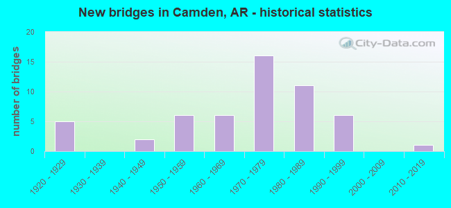
- New bridges - historical statistics
- 51920-1929
- 21940-1949
- 61950-1959
- 61960-1969
- 161970-1979
- 111980-1989
- 61990-1999
- 12010-2019
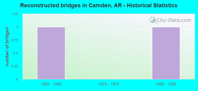
- Reconstructed bridges - Historical Statistics
- 11960-1969
- 01970-1979
- 11980-1989
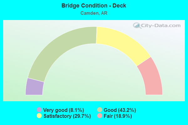
- Bridge Condition - Deck
- 8.1%Very good
- 43.2%Good
- 29.7%Satisfactory
- 18.9%Fair
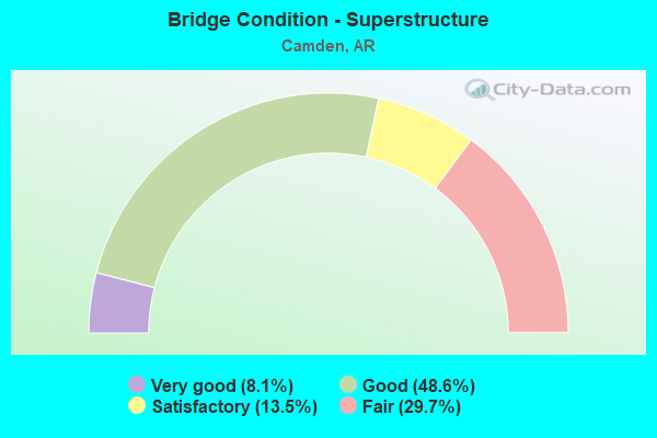
- Bridge Condition - Superstructure
- 8.1%Very good
- 48.6%Good
- 13.5%Satisfactory
- 29.7%Fair
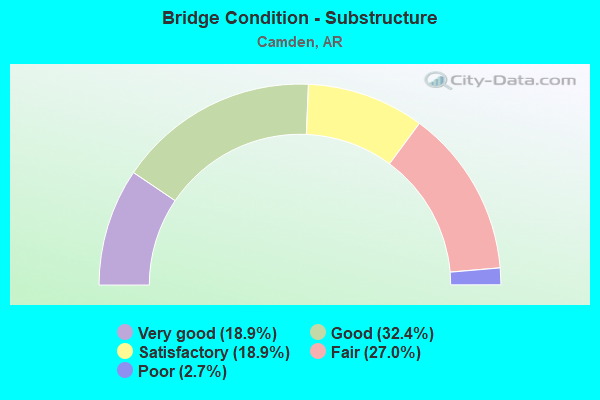
- Bridge Condition - Substructure
- 18.9%Very good
- 32.4%Good
- 18.9%Satisfactory
- 27.0%Fair
- 2.7%Poor
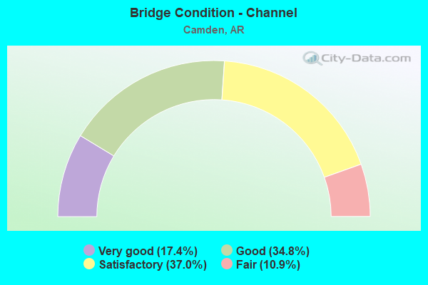
- Bridge Condition - Channel
- 17.4%Very good
- 34.8%Good
- 37.0%Satisfactory
- 10.9%Fair
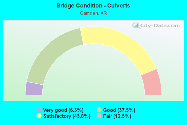
- Bridge Condition - Culverts
- 6.3%Very good
- 37.5%Good
- 43.8%Satisfactory
- 12.5%Fair
Find on map >> Show street view
Structure Number: B379, Location: 1.53 MI W JCT US 79 (Lat: 33.580500, Lng: -92.859478), Route carried "on" structure: US 278, Year Built: 1965, Status: Open, Structure Length: 3.41m (11.19ft), Average Daily Traffic: 3,700 (year 2018), Truck Traffic: 14%, Average Future Daily Traffic: 3,700 (year 2038), Design Load: HS 20, Features Intersected: WADLEIGH BR.
Minimum Vertical Clearance: 30+ m (98+ ft), Kilometerpoint: 26.474, Lanes on structure: 2, Base Highway Network: Yes, Owner: State Highway Agency, Approaching Roadway Width: 12.2m (40.0ft), Skew: 2 degrees, Material/Design: Concrete, Design/Construction: Slab, Number Of Spans In Main Unit: 4, Length of Maximum Span: 8.5m (27.9ft), Curb-To-Curb Width: 12.2m (40.0ft), Out-to-Out Width: 13.5m (44.3ft)
Condition: Deck: Fair, Superstructure: Fair, Substructure: Good, Channel: Good, Operating Rating: 54.4 metric tons, Method Used To Determine Operating Rating: Load Factor (LF), Inventory Rating: 32.7 metric tons, Method Used To Determine Inventory Rating: Load Factor (LF), Structural Evaluation: Somewhat better than minimum adequacy, Deck Geometry: Equal to present minimum criteria, Waterway Adequacy: Better than present minimum criteria, Approach Roadway Alignment: Equal to present desirable criteria, Designated Inspection Frequency: Every 24 months, Critical Feature Inspection Frequency: Every 24 months, Inspection Date: August 2020, Deck Structure Type: Concrete Cast-file-Place, Wearing Surface/Protective System: Wearing Surface: Monolithic Concrete
Find on map >> Show street view
Structure Number: B3791, Location: .62 MI W JCT US278/US 79B (Lat: 33.571550, Lng: -92.848589), Route carried "on" structure: US 278, Year Built: 1965, Status: Open, Structure Length: 3.05m (10.01ft), Average Daily Traffic: 4,624 (year 2018), Truck Traffic: 1%, Average Future Daily Traffic: 5,500 (year 2028), Design Load: HS 20, Features Intersected: WADLEIGH BR.
Minimum Vertical Clearance: 30+ m (98+ ft), Kilometerpoint: 27.938, Lanes on structure: 2, Base Highway Network: Yes, Owner: State Highway Agency, Approaching Roadway Width: 12.2m (40.0ft), Material/Design: Concrete, Design/Construction: Slab, Number Of Spans In Main Unit: 4, Length of Maximum Span: 7.6m (24.9ft), Curb-To-Curb Width: 12.2m (40.0ft), Out-to-Out Width: 13.5m (44.3ft)
Condition: Deck: Fair, Superstructure: Fair, Substructure: Good, Channel: Very good, Operating Rating: 54.4 metric tons, Method Used To Determine Operating Rating: Load Factor (LF), Inventory Rating: 32.7 metric tons, Method Used To Determine Inventory Rating: Load Factor (LF), Structural Evaluation: Somewhat better than minimum adequacy, Deck Geometry: Better than present minimum criteria, Waterway Adequacy: Equal to present desirable criteria, Approach Roadway Alignment: Equal to present desirable criteria, Designated Inspection Frequency: Every 24 months, Critical Feature Inspection Frequency: Every 24 months, Inspection Date: August 2020, Deck Structure Type: Concrete Cast-file-Place
Find on map >> Show street view
Structure Number: B5347, Location: 0.13 MI E OF JCT SH 7 (Lat: 33.568539, Lng: -92.823428), Route carried "on" structure: US 79, Year Built: 1973, Status: Open, Structure Length: 10.94m (35.89ft), Average Daily Traffic: 6,000 (year 2018), Truck Traffic: 12%, Average Future Daily Traffic: 13,100 (year 2038), Design Load: HS 20, Features Intersected: UPRR & ST.SW RR
Minimum Vertical Clearance: 30+ m (98+ ft), Kilometerpoint: 1.320, Lanes on structure: 3, Base Highway Network: Yes, Owner: State Highway Agency, Approaching Roadway Width: 15.8m (51.8ft), Skew: 2 degrees, Material/Design: Steel, Design/Construction: Stringer/Multi-beam, Number Of Spans In Main Unit: 6, Length of Maximum Span: 22.6m (74.1ft), Curb-To-Curb Width: 15.5m (50.9ft), Out-to-Out Width: 16.5m (54.1ft)
Condition: Deck: Satisfactory, Superstructure: Good, Substructure: Very good, Operating Rating: 54.4 metric tons, Method Used To Determine Operating Rating: Load Factor (LF), Inventory Rating: 32.7 metric tons, Method Used To Determine Inventory Rating: Load Factor (LF), Structural Evaluation: Better than present minimum criteria, Deck Geometry: Equal to present minimum criteria, Underclear: Equal to present desirable criteria, Approach Roadway Alignment: Equal to present desirable criteria, Designated Inspection Frequency: Every 24 months, Critical Feature Inspection Frequency: Every 24 months, Inspection Date: September 2020, Deck Structure Type: Concrete Cast-file-Place, Wearing Surface/Protective System: Wearing Surface: Monolithic Concrete
Find on map >> Show street view
Structure Number: B5901, Location: .3 MI S JCT SH 376 (Lat: 33.500178, Lng: -92.831419), Route carried "on" structure: State highway 7, Year Built: 1982, Status: Open, Structure Length: 10.06m (33.01ft), Average Daily Traffic: 6,000 (year 2018), Truck Traffic: 14%, Average Future Daily Traffic: 2,900 (year 2038), Design Load: HS 20, Features Intersected: MILL CREEK-UPRR
Minimum Vertical Clearance: 30+ m (98+ ft), Kilometerpoint: 15.640, Lanes on structure: 2, Base Highway Network: Yes, Owner: State Highway Agency, Approaching Roadway Width: 12.2m (40.0ft), Skew: 4 degrees, Material/Design: Steel continuous, Design/Construction: Stringer/Multi-beam, Number Of Spans In Main Unit: 5, Length of Maximum Span: 21.0m (68.9ft), Curb-To-Curb Width: 12.2m (40.0ft), Out-to-Out Width: 13.1m (43.0ft)
Condition: Deck: Good, Superstructure: Good, Substructure: Very good, Channel: Very good, Operating Rating: 54.4 metric tons, Method Used To Determine Operating Rating: Load Factor (LF), Inventory Rating: 32.7 metric tons, Method Used To Determine Inventory Rating: Load Factor (LF), Structural Evaluation: Better than present minimum criteria, Deck Geometry: Better than present minimum criteria, Underclear: Superior to present desirable criteria, Waterway Adequacy: Equal to present desirable criteria, Approach Roadway Alignment: Equal to present desirable criteria, Designated Inspection Frequency: Every 24 months, Critical Feature Inspection Frequency: Every 24 months, Inspection Date: Febuary 2020, Deck Structure Type: Concrete Cast-file-Place, Wearing Surface/Protective System: Wearing Surface: Monolithic Concrete
Find on map >> Show street view
Structure Number: B65, Location: US278 OVER JCT US 79/79B (Lat: 33.570039, Lng: -92.838081), Route carried "on" structure: US 278, Year Built: 1995, Status: Open, Structure Length: 6.34m (20.80ft), Average Daily Traffic: 5,000 (year 2018), Truck Traffic: 1%, Average Future Daily Traffic: 5,443 (year 2028), Design Load: HS 20, Features Intersected: @ JCT US 79/79B
Minimum Vertical Clearance: 30+ m (98+ ft), Kilometerpoint: 28.888, Lanes on structure: 3, Lanes under structure: 5, Owner: State Highway Agency, Approaching Roadway Width: 14.6m (47.9ft), Skew: 2 degrees, Material/Design: Steel continuous, Design/Construction: Stringer/Multi-beam, Number Of Spans In Main Unit: 2, Length of Maximum Span: 30.5m (100.1ft), Curb-To-Curb Width: 14.7m (48.2ft), Out-to-Out Width: 15.5m (50.9ft)
Condition: Deck: Good, Superstructure: Very good, Substructure: Very good, Operating Rating: 54.4 metric tons, Method Used To Determine Operating Rating: Load Factor (LF), Inventory Rating: 32.7 metric tons, Method Used To Determine Inventory Rating: Load Factor (LF), Structural Evaluation: Equal to present desirable criteria, Deck Geometry: Somewhat better than minimum adequacy, Underclear: Equal to present minimum criteria, Approach Roadway Alignment: Superior to present desirable criteria, Designated Inspection Frequency: Every 24 months, Critical Feature Inspection Frequency: Every 24 months, Inspection Date: July 2021, Deck Structure Type: Concrete Cast-file-Place, Wearing Surface/Protective System: Wearing Surface: Epoxy Overlay
Find on map >> Show street view
Structure Number: M0085, Location: JCT SH 278B (Lat: 33.586100, Lng: -92.867769), Route carried "on" structure: US 278, Year Built: 1928, Status: Open, Structure Length: 0.67m (2.20ft), Average Daily Traffic: 5,184 (year 2018), Truck Traffic: 1%, Average Future Daily Traffic: 4,125 (year 2028), Design Load: H 15, Features Intersected: WADLEIGH BR (BERG LAKE )
Minimum Vertical Clearance: 30+ m (98+ ft), Kilometerpoint: 25.407, Lanes on structure: 2, Base Highway Network: Yes, Owner: State Highway Agency, Approaching Roadway Width: 11.0m (36.1ft), Material/Design: Concrete, Design/Construction: Culvert, Number Of Spans In Main Unit: 2, Length of Maximum Span: 3.4m (11.2ft), Curb-To-Curb Width: 9.8m (32.2ft), Out-to-Out Width: 9.8m (32.2ft)
Condition: Channel: Satisfactory, Culverts: Fair, Operating Rating: 26.3 metric tons, Method Used To Determine Operating Rating: Load Factor (LF), Inventory Rating: 16.3 metric tons, Method Used To Determine Inventory Rating: Load Factor (LF), Structural Evaluation: Meets minimum limits, Deck Geometry: Meets minimum limits, Waterway Adequacy: Better than present minimum criteria, Approach Roadway Alignment: Better than present minimum criteria, Designated Inspection Frequency: Every 24 months, Critical Feature Inspection Frequency: Every 24 months, Inspection Date: August 2020
Find on map >> Show street view
Structure Number: M0161, Location: 2.13 MI N JCT US 79B (Lat: 33.621878, Lng: -92.815078), Route carried "on" structure: State highway 7, Year Built: 1950, Status: Open, Structure Length: 2.38m (7.81ft), Average Daily Traffic: 1,100 (year 2018), Truck Traffic: 1%, Average Future Daily Traffic: 1,490 (year 2028), Design Load: H 10, Features Intersected: PALMER BAYOU
Minimum Vertical Clearance: 30+ m (98+ ft), Kilometerpoint: 3.380, Lanes on structure: 2, Owner: State Highway Agency, Approaching Roadway Width: 9.8m (32.2ft), Material/Design: Steel continuous, Design/Construction: Stringer/Multi-beam, Number Of Spans In Main Unit: 4, Length of Maximum Span: 5.8m (19.0ft), Curb-To-Curb Width: 7.1m (23.3ft), Out-to-Out Width: 7.4m (24.3ft)
Condition: Deck: Satisfactory, Superstructure: Fair, Substructure: Satisfactory, Channel: Satisfactory, Operating Rating: 39.0 metric tons, Method Used To Determine Operating Rating: Load Factor (LF), Inventory Rating: 23.6 metric tons, Method Used To Determine Inventory Rating: Load Factor (LF), Structural Evaluation: Somewhat better than minimum adequacy, Deck Geometry: High priority of corrective action, Waterway Adequacy: Equal to present minimum criteria, Approach Roadway Alignment: Somewhat better than minimum adequacy, Length Of Structure Improvement: 3.17m (10.40ft), Designated Inspection Frequency: Every 24 months, Critical Feature Inspection Frequency: Every 24 months, Inspection Date: July 2020, Roadway Improvement Cost: $117,000, Total Project Cost: $307,000, Deck Structure Type: Concrete Cast-file-Place, Wearing Surface/Protective System: Wearing Surface: Bituminous
Find on map >> Show street view
Structure Number: X0183, Location: .82 MI E JCT SH 4 (Lat: 33.585000, Lng: -92.852178), Route carried "on" structure: Business US 278, Year Built: 1950, Year Reconstructed: 1972, Status: Open, Structure Length: 0.85m (2.79ft), Average Daily Traffic: 2,100 (year 2018), Truck Traffic: 1%, Average Future Daily Traffic: 2,865 (year 2028), Design Load: H 20, Features Intersected: CREEK
Minimum Vertical Clearance: 30+ m (98+ ft), Kilometerpoint: 1.320, Lanes on structure: 2, Owner: State Highway Agency, Approaching Roadway Width: 10.4m (34.1ft), Material/Design: Concrete, Design/Construction: Culvert, Number Of Spans In Main Unit: 3, Number Of Approach Spans: 1, Length of Maximum Span: 2.4m (7.9ft), Curb-To-Curb Width: 21.3m (69.9ft), Out-to-Out Width: 21.3m (69.9ft)
Condition: Channel: Good, Culverts: Good, Operating Rating: 50.8 metric tons, Method Used To Determine Operating Rating: Load Factor (LF), Inventory Rating: 30.8 metric tons, Method Used To Determine Inventory Rating: Load Factor (LF), Structural Evaluation: Better than present minimum criteria, Deck Geometry: Superior to present desirable criteria, Waterway Adequacy: Better than present minimum criteria, Approach Roadway Alignment: Better than present minimum criteria, Designated Inspection Frequency: Every 24 months, Critical Feature Inspection Frequency: Every 24 months, Inspection Date: August 2020
Find on map >> Show street view
Structure Number: X0278, Location: 1.0 MI N JCT 7 & 376 (Lat: 33.549319, Lng: -92.828250), Route carried "on" structure: State highway 7, Year Built: 1976, Status: Open, Structure Length: 1.22m (4.00ft), Average Daily Traffic: 8,985 (year 2018), Truck Traffic: 1%, Average Future Daily Traffic: 9,900 (year 2038), Design Load: H 20, Features Intersected: DITCH
Minimum Vertical Clearance: 30+ m (98+ ft), Kilometerpoint: 21.995, Lanes on structure: 4, Base Highway Network: Yes, Owner: State Highway Agency, Approaching Roadway Width: 25.6m (84.0ft), Skew: 24 degrees, Material/Design: Concrete, Design/Construction: Culvert, Number Of Spans In Main Unit: 4, Length of Maximum Span: 2.4m (7.9ft), Out-to-Out Width: 39.6m (129.9ft)
Condition: Channel: Satisfactory, Culverts: Good, Operating Rating: 47.2 metric tons, Method Used To Determine Operating Rating: Load Factor (LF), Inventory Rating: 28.1 metric tons, Method Used To Determine Inventory Rating: Load Factor (LF), Structural Evaluation: Better than present minimum criteria, Waterway Adequacy: Equal to present minimum criteria, Approach Roadway Alignment: Equal to present desirable criteria, Designated Inspection Frequency: Every 24 months, Critical Feature Inspection Frequency: Every 24 months, Inspection Date: August 2021
Find on map >> Show street view
Structure Number: X0431, Location: .3 N JCT HWY 7 & 376 (Lat: 33.507089, Lng: -92.840458), Route carried "on" structure: State highway 7, Year Built: 1979, Status: Open, Structure Length: 1.22m (4.00ft), Average Daily Traffic: 5,500 (year 2018), Truck Traffic: 14%, Average Future Daily Traffic: 5,615 (year 2028), Design Load: H 20, Features Intersected: MILL CREEK
Minimum Vertical Clearance: 30+ m (98+ ft), Kilometerpoint: 16.863, Lanes on structure: 4, Base Highway Network: Yes, Owner: State Highway Agency, Approaching Roadway Width: 11.6m (38.1ft), Material/Design: Concrete, Design/Construction: Culvert, Number Of Spans In Main Unit: 4, Length of Maximum Span: 2.7m (8.9ft)
Condition: Channel: Good, Culverts: Satisfactory, Operating Rating: 35.4 metric tons, Method Used To Determine Operating Rating: Load Factor (LF), Inventory Rating: 20.9 metric tons, Method Used To Determine Inventory Rating: Load Factor (LF), Structural Evaluation: Somewhat better than minimum adequacy, Waterway Adequacy: Equal to present minimum criteria, Approach Roadway Alignment: Equal to present desirable criteria, Designated Inspection Frequency: Every 24 months, Critical Feature Inspection Frequency: Every 24 months, Inspection Date: Febuary 2020
Find on map >> Show street view
Structure Number: X0494, Location: 1.1 SO JCT SH 7 & 376 (Lat: 33.492100, Lng: -92.820361), Route carried "on" structure: State highway 7, Year Built: 1982, Status: Open, Structure Length: 0.73m (2.40ft), Average Daily Traffic: 5,008 (year 2018), Truck Traffic: 1%, Average Future Daily Traffic: 5,271 (year 2028), Design Load: H 20, Features Intersected: CREEK
Minimum Vertical Clearance: 30+ m (98+ ft), Kilometerpoint: 15.012, Lanes on structure: 4, Base Highway Network: Yes, Owner: State Highway Agency, Approaching Roadway Width: 24.4m (80.1ft), Skew: 3 degrees, Material/Design: Concrete, Design/Construction: Culvert, Number Of Spans In Main Unit: 2, Length of Maximum Span: 3.4m (11.2ft)
Condition: Channel: Very good, Culverts: Satisfactory, Operating Rating: 54.4 metric tons, Method Used To Determine Operating Rating: Load Factor (LF), Inventory Rating: 32.7 metric tons, Method Used To Determine Inventory Rating: Load Factor (LF), Structural Evaluation: Equal to present minimum criteria, Waterway Adequacy: Equal to present desirable criteria, Approach Roadway Alignment: Equal to present desirable criteria, Designated Inspection Frequency: Every 24 months, Critical Feature Inspection Frequency: Every 24 months, Inspection Date: August 2021
Find on map >> Show street view
Structure Number: X0617, Location: SH 376 SEC 1 (Lat: 33.535697, Lng: -92.857319), Route carried "on" structure: State highway 376, Year Built: 1940, Status: Open, Structure Length: 0.70m (2.30ft), Average Daily Traffic: 2,000 (year 2018), Truck Traffic: 1%, Average Future Daily Traffic: 2,521 (year 2028), Features Intersected: CHAFFIE CREEK
Minimum Vertical Clearance: 30+ m (98+ ft), Kilometerpoint: 7.289, Lanes on structure: 2, Owner: State Highway Agency, Approaching Roadway Width: 8.5m (27.9ft), Material/Design: Concrete, Design/Construction: Culvert, Number Of Spans In Main Unit: 2, Length of Maximum Span: 3.0m (9.8ft), Curb-To-Curb Width: 9.1m (29.9ft), Out-to-Out Width: 9.8m (32.2ft)
Condition: Channel: Satisfactory, Culverts: Satisfactory, Operating Rating: 28.1 metric tons, Method Used To Determine Operating Rating: Load Factor (LF), Inventory Rating: 17.2 metric tons, Method Used To Determine Inventory Rating: Load Factor (LF), Structural Evaluation: Meets minimum limits, Deck Geometry: Somewhat better than minimum adequacy, Waterway Adequacy: Equal to present minimum criteria, Approach Roadway Alignment: Better than present minimum criteria, Designated Inspection Frequency: Every 24 months, Critical Feature Inspection Frequency: Every 24 months, Inspection Date: July 2020
Find on map >> Show street view
Structure Number: 197, Location: .8 MI SW JCT SH 7 (Lat: 33.587869, Lng: -92.827031), Route carried "under" structure: Business US 79, Structure Length: 0. m, Average Daily Traffic: 4,500 (year 2014), Truck Traffic: 1%, Features Intersected: US 79-SEC 4/B, Facility Carried by Structure: SL-SW RR
Minimum Vertical Clearance: 4.19m (13.75ft), Kilometerpoint: 2.511, Length of Maximum Span: 0.0m
Find on map >> Show street view
Structure Number: 3793, Location: LINCOLN DRIVE (Lat: 33.568800, Lng: -92.829331), Route carried "under" structure: US 79, Structure Length: 0. m, Average Daily Traffic: 3,950 (year 2014), Truck Traffic: 1%, Features Intersected: US 79 SEC 4 LOG ML .50, Facility Carried by Structure: LINCOLN ST.
Minimum Vertical Clearance: 4.66m (15.29ft), Kilometerpoint: 0.756, Length of Maximum Span: 0.0m
Find on map >> Show street view
Structure Number: 3793, Location: LINCOLN DRIVE (Lat: 33.568800, Lng: -92.829331), Route carried "under" structure: US 79, Structure Length: 0. m, Average Daily Traffic: 3,950 (year 2014), Truck Traffic: 1%, Features Intersected: US 79 SEC 4 LOG ML .50, Facility Carried by Structure: LINCOLN ST.
Minimum Vertical Clearance: 4.90m (16.08ft), Kilometerpoint: 0.756, Length of Maximum Span: 0.0m
Find on map >> Show street view
Structure Number: 3794, Location: INTERSEC US 79 & SH 7 (Lat: 33.568581, Lng: -92.827839), Route carried "under" structure: US 79, Structure Length: 0. m, Average Daily Traffic: 5,000 (year 2014), Truck Traffic: 1%, Features Intersected: US 79-SEC 4 LOG MI 0.60, Facility Carried by Structure: SH 7-S-3 LM 15.06
Minimum Vertical Clearance: 4.90m (16.08ft), Kilometerpoint: 0.901, Length of Maximum Span: 0.0m
Find on map >> Show street view
Structure Number: 3794, Location: INTERSEC US 79 & SH 7 (Lat: 33.568581, Lng: -92.827839), Route carried "under" structure: US 79, Structure Length: 0. m, Average Daily Traffic: 5,000 (year 2014), Truck Traffic: 1%, Features Intersected: US 79-SEC 4 LOG MI 0.60, Facility Carried by Structure: SH 7-S-3 LM 15.06
Minimum Vertical Clearance: 4.52m (14.83ft), Kilometerpoint: 0.901, Length of Maximum Span: 0.0m
Find on map >> Show street view
Structure Number: A65, Location: JCT US 278 OVER US 79/79B (Lat: 33.570231, Lng: -92.837939), Route carried "under" structure: US 79, Structure Length: 0. m, Average Daily Traffic: 6,600 (year 2014), Truck Traffic: 1%, Features Intersected: US 79/79B MN LNS, Facility Carried by Structure: US278 S-8LM17.9WB
Minimum Vertical Clearance: 6.12m (20.08ft), Kilometerpoint: 34.512, Length of Maximum Span: 0.0m
Find on map >> Show street view
Structure Number: B65, Location: US278 OVER JCT US 79/79B (Lat: 33.570039, Lng: -92.838081), Route carried "under" structure: US 79, Structure Length: 0. m, Average Daily Traffic: 6,600 (year 2014), Truck Traffic: 1%, Features Intersected: @ JCT US 79/79B, Facility Carried by Structure: US 278 SEC 8, EB L
Minimum Vertical Clearance: 5.82m (19.09ft), Kilometerpoint: 34.512, Length of Maximum Span: 0.0m
Find on map >> Show street view
Structure Number: M016, Location: 0.80 MI NW JCT 79B (Lat: 33.606639, Lng: -92.820153), Route carried "under" structure: State highway 7, Structure Length: 0. m, Average Daily Traffic: 1,300 (year 2014), Truck Traffic: 1%, Features Intersected: SH 7-SEC 4, Facility Carried by Structure: UNION PACIFIC RR
Minimum Vertical Clearance: 3.86m (12.66ft), Kilometerpoint: 6.759, Length of Maximum Span: 0.0m