Bridge Statistics for Bunnell, Florida (FL)
Condition, Traffic, Stress, Structural Evaluation, Project Costs
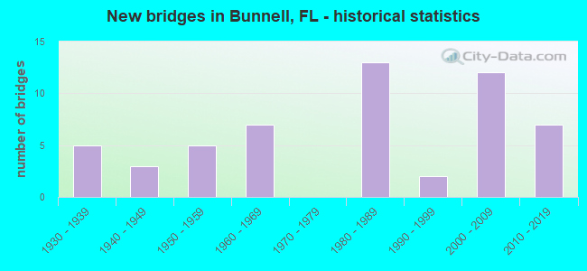
- New bridges - historical statistics
- 51930-1939
- 31940-1949
- 51950-1959
- 71960-1969
- 131980-1989
- 21990-1999
- 122000-2009
- 72010-2019

- Reconstructed bridges - Historical Statistics
- 11970-1979
- 11980-1989
- 71990-1999
- 02000-2009
- 12010-2019


- Bridge Condition - Deck
- 11.1%Very good
- 72.2%Good
- 13.9%Satisfactory
- 2.8%Fair

- Bridge Condition - Superstructure
- 16.7%Very good
- 58.3%Good
- 19.4%Satisfactory
- 5.6%Fair

- Bridge Condition - Substructure
- 13.9%Very good
- 63.9%Good
- 16.7%Satisfactory
- 5.6%Fair

- Bridge Condition - Channel
- 13.5%Very good
- 53.8%Good
- 21.2%Satisfactory
- 11.5%Fair

- Bridge Condition - Culverts
- 41.2%Good
- 58.8%Satisfactory
Find on map >> Show street view
Structure Number: 730011, Location: 3.0 Mi W of CR-305 (Lat: 29.480950, Lng: -81.422417), Route carried "on" structure: State highway 20, Year Built: 1936, Year Reconstructed: 1996, Status: Open, Structure Length: 1.31m (4.30ft), Average Daily Traffic: 4,700 (year 2020), Truck Traffic: 5%, Average Future Daily Traffic: 8,154 (year 2042), Features Intersected: Water Oak Brook
Minimum Vertical Clearance: 30+ m (98+ ft), Kilometerpoint: 12.271, Lanes on structure: 2, Base Highway Network: Yes, Owner: State Highway Agency, Approaching Roadway Width: 9.9m (32.5ft), Material/Design: Concrete, Design/Construction: Culvert, Number Of Spans In Main Unit: 4, Length of Maximum Span: 3.4m (11.2ft)
Condition: Channel: Satisfactory, Culverts: Good, Operating Rating: 54.4 metric tons, Method Used To Determine Operating Rating: Load Testing, Inventory Rating: 48.0 metric tons, Method Used To Determine Inventory Rating: Load Testing, Structural Evaluation: Better than present minimum criteria, Waterway Adequacy: Equal to present minimum criteria, Approach Roadway Alignment: Equal to present desirable criteria, Length Of Structure Improvement: 1.31m (4.30ft), Designated Inspection Frequency: Every 24 months, Inspection Date: September 2021, Bridge Improvement Cost: $70,000, Total Project Cost: $209,000
Find on map >> Show street view
Structure Number: 730013, Location: 2.3 Mi W of US-1 (Lat: 29.467800, Lng: -81.303897), Route carried "on" structure: State highway 100, Year Built: 1936, Year Reconstructed: 2002, Status: Open, Structure Length: 0.98m (3.22ft), Average Daily Traffic: 8,900 (year 2020), Truck Traffic: 13%, Average Future Daily Traffic: 15,442 (year 2042), Design Load: H 15, Features Intersected: Canal
Minimum Vertical Clearance: 30+ m (98+ ft), Kilometerpoint: 24.100, Lanes on structure: 2, Base Highway Network: Yes, Owner: State Highway Agency, Approaching Roadway Width: 9.8m (32.2ft), Material/Design: Concrete, Design/Construction: Culvert, Number Of Spans In Main Unit: 3, Length of Maximum Span: 3.0m (9.8ft)
Condition: Channel: Good, Culverts: Satisfactory, Operating Rating: 53.9 metric tons, Method Used To Determine Operating Rating: Load Testing, Inventory Rating: 32.7 metric tons, Method Used To Determine Inventory Rating: Load Testing, Structural Evaluation: Equal to present minimum criteria, Waterway Adequacy: Better than present minimum criteria, Approach Roadway Alignment: Equal to present desirable criteria, Length Of Structure Improvement: 0.98m (3.22ft), Designated Inspection Frequency: Every 24 months, Inspection Date: October 2021, Bridge Improvement Cost: $52,000, Total Project Cost: $209,000
Find on map >> Show street view
Structure Number: 730023, Location: 1.4 Mi N of Vol. Co. Line (Lat: 29.364578, Lng: -81.169653), Route carried "on" structure: US 5, Year Built: 1940, Year Reconstructed: 2001, Status: Open, Structure Length: 0.64m (2.10ft), Average Daily Traffic: 11,283 (year 2020), Truck Traffic: 11%, Average Future Daily Traffic: 19,576 (year 2042), Features Intersected: Favorita Canal, Facility Carried by Structure: US-1
Minimum Vertical Clearance: 30+ m (98+ ft), Kilometerpoint: 2.158, Lanes on structure: 4, Base Highway Network: Yes, Owner: State Highway Agency, Approaching Roadway Width: 18.2m (59.7ft), Skew: 20 degrees, Material/Design: Concrete, Design/Construction: Culvert, Number Of Spans In Main Unit: 2, Length of Maximum Span: 3.0m (9.8ft)
Condition: Channel: Good, Culverts: Satisfactory, Operating Rating: 41.8 metric tons, Method Used To Determine Operating Rating: Load and Resistance Factor (LRFR), Inventory Rating: 32.7 metric tons, Method Used To Determine Inventory Rating: Load and Resistance Factor (LRFR), Structural Evaluation: Equal to present minimum criteria, Waterway Adequacy: Equal to present desirable criteria, Approach Roadway Alignment: Equal to present desirable criteria, Designated Inspection Frequency: Every 24 months, Underwater Inspection Frequency: Every 24 months, Inspection Date: January 2022, Underwater Inspection Date: January 2022
Find on map >> Show street view
Structure Number: 730024, Location: US-1 in Bunnell (Lat: 29.468400, Lng: -81.261506), Route carried "on" structure: US 5, Year Built: 1957, Status: Open, Structure Length: 0.88m (2.89ft), Average Daily Traffic: 18,200 (year 2020), Truck Traffic: 11%, Average Future Daily Traffic: 31,577 (year 2042), Design Load: H 15, Features Intersected: Canal, Facility Carried by Structure: US-1
Minimum Vertical Clearance: 30+ m (98+ ft), Kilometerpoint: 17.094, Lanes on structure: 5, Base Highway Network: Yes, Owner: State Highway Agency, Approaching Roadway Width: 24.4m (80.1ft), Skew: 24 degrees, Material/Design: Concrete, Design/Construction: Culvert, Number Of Spans In Main Unit: 2, Length of Maximum Span: 3.0m (9.8ft)
Condition: Channel: Satisfactory, Culverts: Good, Operating Rating: 60.5 metric tons, Method Used To Determine Operating Rating: Load Factor (LF), Inventory Rating: 36.3 metric tons, Method Used To Determine Inventory Rating: Load Factor (LF), Structural Evaluation: Better than present minimum criteria, Waterway Adequacy: Equal to present desirable criteria, Approach Roadway Alignment: Equal to present desirable criteria, Length Of Structure Improvement: 5.48m (17.98ft), Designated Inspection Frequency: Every 24 months, Inspection Date: October 2021, Bridge Improvement Cost: $91,000, Total Project Cost: $120,000
Find on map >> Show street view
Structure Number: 730052, Location: 5.4 Mi W of CR-305 (Lat: 29.485303, Lng: -81.460825), Route carried "on" structure: State highway 20, Year Built: 1936, Year Reconstructed: 1987, Status: Open, Structure Length: 0.64m (2.10ft), Average Daily Traffic: 4,700 (year 2020), Truck Traffic: 5%, Average Future Daily Traffic: 8,154 (year 2042), Design Load: H 20, Features Intersected: Unnamed Canal
Minimum Vertical Clearance: 30+ m (98+ ft), Kilometerpoint: 8.449, Lanes on structure: 2, Base Highway Network: Yes, Owner: State Highway Agency, Approaching Roadway Width: 9.8m (32.2ft), Material/Design: Concrete, Design/Construction: Culvert, Number Of Spans In Main Unit: 2, Length of Maximum Span: 3.0m (9.8ft)
Condition: Channel: Fair, Culverts: Good, Operating Rating: 53.9 metric tons, Method Used To Determine Operating Rating: Load Testing, Inventory Rating: 32.7 metric tons, Method Used To Determine Inventory Rating: Load Testing, Structural Evaluation: Better than present minimum criteria, Waterway Adequacy: Meets minimum limits, Approach Roadway Alignment: Equal to present desirable criteria, Length Of Structure Improvement: 0.64m (2.10ft), Designated Inspection Frequency: Every 24 months, Inspection Date: September 2021, Bridge Improvement Cost: $34,000, Total Project Cost: $209,000
Find on map >> Show street view
Structure Number: 730053, Location: 1.3 Mi W of US-1 (Lat: 29.466897, Lng: -81.287600), Route carried "on" structure: State highway 100, Year Built: 1936, Year Reconstructed: 2002, Status: Open, Structure Length: 0.64m (2.10ft), Average Daily Traffic: 8,900 (year 2020), Truck Traffic: 13%, Average Future Daily Traffic: 15,442 (year 2042), Design Load: HS 20, Features Intersected: Black Swamp Canal
Minimum Vertical Clearance: 30+ m (98+ ft), Kilometerpoint: 25.685, Lanes on structure: 2, Base Highway Network: Yes, Owner: State Highway Agency, Approaching Roadway Width: 9.8m (32.2ft), Material/Design: Concrete, Design/Construction: Culvert, Number Of Spans In Main Unit: 2, Length of Maximum Span: 3.0m (9.8ft)
Condition: Channel: Very good, Culverts: Satisfactory, Operating Rating: 54.4 metric tons, Method Used To Determine Operating Rating: Load Factor (LF), Inventory Rating: 32.7 metric tons, Method Used To Determine Inventory Rating: Load Factor (LF), Structural Evaluation: Equal to present minimum criteria, Waterway Adequacy: Equal to present desirable criteria, Approach Roadway Alignment: Equal to present desirable criteria, Designated Inspection Frequency: Every 24 months, Underwater Inspection Frequency: Every 24 months, Inspection Date: December 2021, Underwater Inspection Date: December 2021
Find on map >> Show street view
Structure Number: 730061, Location: SR-11 - Sweetwater Branch (Lat: 29.418658, Lng: -81.301994), Route carried "on" structure: State highway 11, Year Built: 2001, Status: Open, Structure Length: 5.06m (16.60ft), Average Daily Traffic: 3,800 (year 2020), Truck Traffic: 15%, Average Future Daily Traffic: 6,593 (year 2042), Design Load: HS 25 or greater, Features Intersected: Sweetwater Branch
Minimum Vertical Clearance: 30+ m (98+ ft), Kilometerpoint: 18.047, Lanes on structure: 2, Owner: State Highway Agency, Approaching Roadway Width: 13.4m (44.0ft), Material/Design: Concrete continuous, Design/Construction: Slab, Number Of Spans In Main Unit: 5, Length of Maximum Span: 10.0m (32.8ft), Curb-To-Curb Width: 13.4m (44.0ft), Out-to-Out Width: 14.6m (47.9ft)
Condition: Deck: Good, Superstructure: Good, Substructure: Good, Channel: Good, Operating Rating: 88.5 metric tons, Method Used To Determine Operating Rating: Load Factor (LF), Inventory Rating: 53.1 metric tons, Method Used To Determine Inventory Rating: Load Factor (LF), Structural Evaluation: Better than present minimum criteria, Deck Geometry: Better than present minimum criteria, Waterway Adequacy: Equal to present desirable criteria, Approach Roadway Alignment: Equal to present desirable criteria, Designated Inspection Frequency: Every 24 months, Underwater Inspection Frequency: Every 24 months, Inspection Date: October 2020, Underwater Inspection Date: October 2020, Deck Structure Type: Concrete Cast-file-Place, Wearing Surface/Protective System: Wearing Surface: Monolithic Concrete
Find on map >> Show street view
Structure Number: 730062, Location: SR-11 over Parker Canal (Lat: 29.430542, Lng: -81.290231), Route carried "on" structure: State highway 11, Year Built: 2001, Status: Open, Structure Length: 0.75m (2.46ft), Average Daily Traffic: 3,800 (year 2020), Truck Traffic: 15%, Average Future Daily Traffic: 6,593 (year 2042), Design Load: HS 25 or greater, Features Intersected: Parker Canal
Minimum Vertical Clearance: 30+ m (98+ ft), Kilometerpoint: 19.835, Lanes on structure: 2, Owner: State Highway Agency, Approaching Roadway Width: 9.1m (29.9ft), Skew: 5 degrees, Material/Design: Concrete, Design/Construction: Culvert, Number Of Spans In Main Unit: 2, Length of Maximum Span: 3.7m (12.1ft)
Condition: Channel: Good, Culverts: Good, Inventory Rating: 64.7 metric tons, Method Used To Determine Inventory Rating: Load Factor (LF), Structural Evaluation: Better than present minimum criteria, Waterway Adequacy: Equal to present desirable criteria, Approach Roadway Alignment: Equal to present desirable criteria, Designated Inspection Frequency: Every 24 months, Inspection Date: November 2020
Find on map >> Show street view
Structure Number: 730063, Location: SR-11 over Bunnell Canal (Lat: 29.452828, Lng: -81.269733), Route carried "on" structure: State highway 11, Year Built: 2001, Status: Open, Structure Length: 0.64m (2.10ft), Average Daily Traffic: 3,800 (year 2020), Truck Traffic: 15%, Average Future Daily Traffic: 6,593 (year 2042), Design Load: HL 93, Features Intersected: Bunnell Canal
Minimum Vertical Clearance: 30+ m (98+ ft), Kilometerpoint: 23.044, Lanes on structure: 2, Owner: State Highway Agency, Approaching Roadway Width: 9.1m (29.9ft), Skew: 4 degrees, Material/Design: Concrete, Design/Construction: Culvert, Number Of Spans In Main Unit: 2, Length of Maximum Span: 3.0m (9.8ft)
Condition: Channel: Good, Culverts: Good, Structural Evaluation: Better than present minimum criteria, Waterway Adequacy: Better than present minimum criteria, Approach Roadway Alignment: Equal to present desirable criteria, Designated Inspection Frequency: Every 24 months, Inspection Date: December 2020
Find on map >> Show street view
Structure Number: 730064, Location: 3.1 Mi. N of Volusia Line (Lat: 29.385000, Lng: -81.188447), Route carried "on" structure: US 5, Year Built: 1940, Year Reconstructed: 1997, Status: Open, Structure Length: 0.64m (2.10ft), Average Daily Traffic: 11,283 (year 2020), Truck Traffic: 11%, Average Future Daily Traffic: 19,576 (year 2042), Features Intersected: Outfall Ditch, Facility Carried by Structure: US-1
Minimum Vertical Clearance: 30+ m (98+ ft), Kilometerpoint: 5.073, Lanes on structure: 4, Owner: State Highway Agency, Approaching Roadway Width: 18.5m (60.7ft), Skew: 20 degrees, Material/Design: Concrete, Design/Construction: Culvert, Number Of Spans In Main Unit: 2, Length of Maximum Span: 3.0m (9.8ft)
Condition: Channel: Good, Culverts: Satisfactory, Operating Rating: 42.3 metric tons, Method Used To Determine Operating Rating: Load and Resistance Factor (LRFR), Inventory Rating: 32.7 metric tons, Method Used To Determine Inventory Rating: Load and Resistance Factor (LRFR), Structural Evaluation: Equal to present minimum criteria, Waterway Adequacy: Equal to present desirable criteria, Approach Roadway Alignment: Equal to present desirable criteria, Designated Inspection Frequency: Every 24 months, Underwater Inspection Frequency: Every 24 months, Inspection Date: May 2021, Underwater Inspection Date: May 2021
Find on map >> Show street view
Structure Number: 730065, Location: 4.3 Mi. N of Volusia Line (Lat: 29.401617, Lng: -81.194483), Route carried "on" structure: US 5, Year Built: 1940, Year Reconstructed: 1998, Status: Open, Structure Length: 0.67m (2.20ft), Average Daily Traffic: 11,283 (year 2020), Truck Traffic: 11%, Average Future Daily Traffic: 19,576 (year 2042), Features Intersected: Outfall Ditch, Facility Carried by Structure: US-1
Minimum Vertical Clearance: 30+ m (98+ ft), Kilometerpoint: 6.997, Lanes on structure: 5, Owner: State Highway Agency, Approaching Roadway Width: 22.9m (75.1ft), Skew: 20 degrees, Material/Design: Concrete, Design/Construction: Culvert, Number Of Spans In Main Unit: 2, Length of Maximum Span: 3.4m (11.2ft)
Condition: Channel: Good, Culverts: Satisfactory, Operating Rating: 41.3 metric tons, Method Used To Determine Operating Rating: Load and Resistance Factor (LRFR), Inventory Rating: 32.7 metric tons, Method Used To Determine Inventory Rating: Load and Resistance Factor (LRFR), Structural Evaluation: Equal to present minimum criteria, Waterway Adequacy: Equal to present desirable criteria, Approach Roadway Alignment: Equal to present desirable criteria, Designated Inspection Frequency: Every 24 months, Underwater Inspection Frequency: Every 24 months, Inspection Date: May 2021, Underwater Inspection Date: May 2021
Find on map >> Show street view
Structure Number: 730066, Location: 2.2 Mi E of Putnam Co Ln. (Lat: 29.512492, Lng: -81.498819), Route carried "on" structure: State highway 100, Year Built: 2002, Status: Open, Structure Length: 3.83m (12.57ft), Average Daily Traffic: 4,700 (year 2020), Truck Traffic: 5%, Average Future Daily Traffic: 8,154 (year 2042), Design Load: HS 25 or greater, Features Intersected: Salt Creek
Minimum Vertical Clearance: 30+ m (98+ ft), Kilometerpoint: 3.605, Lanes on structure: 2, Base Highway Network: Yes, Owner: State Highway Agency, Approaching Roadway Width: 10.1m (33.1ft), Skew: 1 degrees, Material/Design: Concrete, Design/Construction: Slab, Number Of Spans In Main Unit: 5, Length of Maximum Span: 7.6m (24.9ft), Curb-To-Curb Width: 13.4m (44.0ft), Out-to-Out Width: 14.3m (46.9ft)
Condition: Deck: Good, Superstructure: Good, Substructure: Good, Channel: Good, Operating Rating: 77.2 metric tons, Method Used To Determine Operating Rating: Load Factor (LF), Inventory Rating: 46.4 metric tons, Method Used To Determine Inventory Rating: Load Factor (LF), Structural Evaluation: Better than present minimum criteria, Deck Geometry: Better than present minimum criteria, Waterway Adequacy: Better than present minimum criteria, Approach Roadway Alignment: Better than present minimum criteria, Designated Inspection Frequency: Every 24 months, Underwater Inspection Frequency: Every 24 months, Inspection Date: January 2022, Underwater Inspection Date: Febuary 2022, Deck Structure Type: Concrete Cast-file-Place, Wearing Surface/Protective System: Wearing Surface: Monolithic Concrete
Find on map >> Show street view
Structure Number: 730067, Location: SR-100-Big Cypress Swamp (Lat: 29.481258, Lng: -81.345236), Route carried "on" structure: State highway 100, Year Built: 2002, Status: Open, Structure Length: 2.35m (7.71ft), Average Daily Traffic: 8,900 (year 2020), Truck Traffic: 13%, Average Future Daily Traffic: 15,442 (year 2042), Design Load: HS 25 or greater, Features Intersected: Big Cypress Swamp
Minimum Vertical Clearance: 30+ m (98+ ft), Kilometerpoint: 19.763, Lanes on structure: 2, Base Highway Network: Yes, Owner: State Highway Agency, Approaching Roadway Width: 10.4m (34.1ft), Material/Design: Concrete continuous, Design/Construction: Slab, Number Of Spans In Main Unit: 3, Length of Maximum Span: 9.1m (29.9ft), Curb-To-Curb Width: 13.1m (43.0ft), Out-to-Out Width: 14.2m (46.6ft)
Condition: Deck: Good, Superstructure: Good, Substructure: Good, Channel: Very good, Operating Rating: 81.3 metric tons, Method Used To Determine Operating Rating: Load Factor (LF), Inventory Rating: 48.8 metric tons, Method Used To Determine Inventory Rating: Load Factor (LF), Structural Evaluation: Better than present minimum criteria, Deck Geometry: Somewhat better than minimum adequacy, Waterway Adequacy: Better than present minimum criteria, Approach Roadway Alignment: Better than present minimum criteria, Designated Inspection Frequency: Every 24 months, Inspection Date: January 2022, Deck Structure Type: Concrete Cast-file-Place, Wearing Surface/Protective System: Wearing Surface: Monolithic Concrete
Find on map >> Show street view
Structure Number: 730068, Location: SR-100 over US-1 (Lat: 29.472153, Lng: -81.266786), Route carried "on" structure: State highway 100, Year Built: 2002, Status: Open, Structure Length: 11.81m (38.75ft), Average Daily Traffic: 8,900 (year 2020), Truck Traffic: 13%, Average Future Daily Traffic: 15,442 (year 2042), Design Load: HS 20, Features Intersected: US-1
Minimum Vertical Clearance: 30+ m (98+ ft), Kilometerpoint: 27.835, Lanes on structure: 2, Lanes under structure: 4, Base Highway Network: Yes, Owner: State Highway Agency, Approaching Roadway Width: 13.2m (43.3ft), Skew: 1 degrees, Material/Design: Prestressed concrete, Design/Construction: Stringer/Multi-beam, Number Of Spans In Main Unit: 3, Length of Maximum Span: 42.7m (140.1ft), Curb-To-Curb Width: 13.2m (43.3ft), Out-to-Out Width: 14.1m (46.3ft)
Condition: Deck: Good, Superstructure: Very good, Substructure: Good, Inventory Rating: 57.9 metric tons, Method Used To Determine Inventory Rating: Load Factor (LF), Structural Evaluation: Better than present minimum criteria, Deck Geometry: Somewhat better than minimum adequacy, Underclear: Better than present minimum criteria, Approach Roadway Alignment: Better than present minimum criteria, Designated Inspection Frequency: Every 24 months, Inspection Date: October 2021, Deck Structure Type: Concrete Cast-file-Place, Wearing Surface/Protective System: Wearing Surface: Monolithic Concrete
Find on map >> Show street view
Structure Number: 730069, Location: SR-11 - Middle Haw Creek (Lat: 29.360081, Lng: -81.311478), Route carried "on" structure: State highway 11, Year Built: 2001, Status: Open, Structure Length: 9.21m (30.22ft), Average Daily Traffic: 3,800 (year 2020), Truck Traffic: 15%, Average Future Daily Traffic: 6,593 (year 2042), Design Load: HS 25 or greater, Features Intersected: Middle Haw Creek
Minimum Vertical Clearance: 30+ m (98+ ft), Kilometerpoint: 11.431, Lanes on structure: 2, Owner: State Highway Agency, Approaching Roadway Width: 10.4m (34.1ft), Material/Design: Concrete continuous, Design/Construction: Slab, Number Of Spans In Main Unit: 9, Length of Maximum Span: 10.1m (33.1ft), Curb-To-Curb Width: 13.5m (44.3ft), Out-to-Out Width: 14.2m (46.6ft)
Condition: Deck: Good, Superstructure: Good, Substructure: Good, Channel: Good, Operating Rating: 78.2 metric tons, Method Used To Determine Operating Rating: Load Factor (LF), Inventory Rating: 46.9 metric tons, Method Used To Determine Inventory Rating: Load Factor (LF), Structural Evaluation: Better than present minimum criteria, Deck Geometry: Superior to present desirable criteria, Waterway Adequacy: Better than present minimum criteria, Approach Roadway Alignment: Equal to present desirable criteria, Designated Inspection Frequency: Every 24 months, Underwater Inspection Frequency: Every 24 months, Inspection Date: October 2020, Underwater Inspection Date: October 2020, Deck Structure Type: Concrete Cast-file-Place, Wearing Surface/Protective System: Wearing Surface: Monolithic Concrete
Find on map >> Show street view
Structure Number: 73007, Location: SR-11 over Black Branch (Lat: 29.446081, Lng: -81.276022), Route carried "on" structure: State highway 11, Year Built: 2001, Status: Open, Structure Length: 3.13m (10.27ft), Average Daily Traffic: 3,800 (year 2020), Truck Traffic: 15%, Average Future Daily Traffic: 6,593 (year 2042), Design Load: HS 25 or greater, Features Intersected: Black Branch
Minimum Vertical Clearance: 30+ m (98+ ft), Kilometerpoint: 22.072, Lanes on structure: 2, Owner: State Highway Agency, Approaching Roadway Width: 13.4m (44.0ft), Material/Design: Concrete continuous, Design/Construction: Slab, Number Of Spans In Main Unit: 3, Length of Maximum Span: 10.3m (33.8ft), Curb-To-Curb Width: 13.5m (44.3ft), Out-to-Out Width: 14.4m (47.2ft)
Condition: Deck: Good, Superstructure: Good, Substructure: Good, Channel: Very good, Operating Rating: 77.9 metric tons, Method Used To Determine Operating Rating: Load Factor (LF), Inventory Rating: 46.7 metric tons, Method Used To Determine Inventory Rating: Load Factor (LF), Structural Evaluation: Better than present minimum criteria, Deck Geometry: Superior to present desirable criteria, Waterway Adequacy: Equal to present desirable criteria, Approach Roadway Alignment: Equal to present desirable criteria, Designated Inspection Frequency: Every 24 months, Underwater Inspection Frequency: Every 24 months, Inspection Date: November 2020, Underwater Inspection Date: December 2020, Deck Structure Type: Concrete Cast-file-Place, Wearing Surface/Protective System: Wearing Surface: Monolithic Concrete
Find on map >> Show street view
Structure Number: 730073, Location: SR-11 - Little Haw Creek (Lat: 29.268803, Lng: -81.336211), Route carried "on" structure: State highway 11, Year Built: 2008, Status: Open, Structure Length: 4.66m (15.29ft), Average Daily Traffic: 3,500 (year 2020), Truck Traffic: 11%, Average Future Daily Traffic: 6,072 (year 2042), Design Load: HL 93, Features Intersected: Little Haw Creek
Minimum Vertical Clearance: 30+ m (98+ ft), Kilometerpoint: 0.739, Lanes on structure: 2, Owner: State Highway Agency, Approaching Roadway Width: 10.1m (33.1ft), Skew: 6 degrees, Material/Design: Concrete, Design/Construction: Slab, Number Of Spans In Main Unit: 5, Length of Maximum Span: 9.3m (30.5ft), Curb-To-Curb Width: 13.4m (44.0ft), Out-to-Out Width: 14.4m (47.2ft)
Condition: Deck: Good, Superstructure: Good, Substructure: Good, Channel: Good, Operating Rating: 45.1 metric tons, Method Used To Determine Operating Rating: Load and Resistance Factor (LRFR), Inventory Rating: 34.9 metric tons, Method Used To Determine Inventory Rating: Load and Resistance Factor (LRFR), Structural Evaluation: Better than present minimum criteria, Deck Geometry: Better than present minimum criteria, Waterway Adequacy: Better than present minimum criteria, Approach Roadway Alignment: Equal to present desirable criteria, Designated Inspection Frequency: Every 24 months, Underwater Inspection Frequency: Every 24 months, Inspection Date: March 2020, Underwater Inspection Date: March 2020, Deck Structure Type: Concrete Cast-file-Place, Wearing Surface/Protective System: Wearing Surface: Monolithic Concrete
Find on map >> Show street view
Structure Number: 730074, Location: US-1 NB over Black Branch (Lat: 29.451697, Lng: -81.245597), Route carried "on" structure: US 1, Year Built: 2010, Status: Open, Structure Length: 3.63m (11.91ft), Average Daily Traffic: 5,800 (year 2020), Truck Traffic: 11%, Average Future Daily Traffic: 10,063 (year 2042), Design Load: HL 93, Features Intersected: Black Branch Creek
Minimum Vertical Clearance: 30.45m (99.90ft), Kilometerpoint: 14.631, Lanes on structure: 2, Base Highway Network: Yes, Owner: State Highway Agency, Approaching Roadway Width: 11.6m (38.1ft), Material/Design: Concrete continuous, Design/Construction: Slab, Number Of Spans In Main Unit: 4, Length of Maximum Span: 9.0m (29.5ft), Curb-To-Curb Width: 12.2m (40.0ft), Out-to-Out Width: 13.1m (43.0ft)
Condition: Deck: Good, Superstructure: Very good, Substructure: Very good, Channel: Very good, Operating Rating: 48.0 metric tons, Method Used To Determine Operating Rating: Load and Resistance Factor (LRFR), Inventory Rating: 37.2 metric tons, Method Used To Determine Inventory Rating: Load and Resistance Factor (LRFR), Structural Evaluation: Equal to present desirable criteria, Deck Geometry: Better than present minimum criteria, Waterway Adequacy: Equal to present desirable criteria, Approach Roadway Alignment: Equal to present desirable criteria, Designated Inspection Frequency: Every 24 months, Inspection Date: June 2020, Deck Structure Type: Concrete Cast-file-Place, Wearing Surface/Protective System: Wearing Surface: Monolithic Concrete
Find on map >> Show street view
Structure Number: 730075, Location: US-1 SB over Black Branch (Lat: 29.451497, Lng: -81.245697), Route carried "on" structure: US 1, Year Built: 2010, Status: Open, Structure Length: 3.63m (11.91ft), Average Daily Traffic: 5,800 (year 2020), Truck Traffic: 11%, Average Future Daily Traffic: 10,063 (year 2042), Design Load: HL 93, Features Intersected: Black Branch Creek
Minimum Vertical Clearance: 30+ m (98+ ft), Kilometerpoint: 14.622, Lanes on structure: 2, Base Highway Network: Yes, Owner: State Highway Agency, Approaching Roadway Width: 11.6m (38.1ft), Material/Design: Concrete continuous, Design/Construction: Slab, Number Of Spans In Main Unit: 4, Length of Maximum Span: 9.0m (29.5ft), Curb-To-Curb Width: 12.2m (40.0ft), Out-to-Out Width: 13.2m (43.3ft)
Condition: Deck: Good, Superstructure: Good, Substructure: Very good, Channel: Very good, Operating Rating: 48.0 metric tons, Method Used To Determine Operating Rating: Load and Resistance Factor (LRFR), Inventory Rating: 37.2 metric tons, Method Used To Determine Inventory Rating: Load and Resistance Factor (LRFR), Structural Evaluation: Better than present minimum criteria, Deck Geometry: Better than present minimum criteria, Waterway Adequacy: Equal to present desirable criteria, Approach Roadway Alignment: Equal to present desirable criteria, Designated Inspection Frequency: Every 24 months, Inspection Date: June 2020, Deck Structure Type: Concrete Cast-file-Place, Wearing Surface/Protective System: Wearing Surface: Monolithic Concrete
Find on map >> Show street view
Structure Number: 73094, Location: US-1 - Korona Canal (Lat: 29.408842, Lng: -81.200267), Route carried "on" structure: US 5, Year Built: 1957, Year Reconstructed: 1979, Status: Open, Structure Length: 1.07m (3.51ft), Average Daily Traffic: 14,100 (year 2020), Truck Traffic: 14%, Average Future Daily Traffic: 24,464 (year 2042), Design Load: HS 15, Features Intersected: Korona Canal, Facility Carried by Structure: US-1
Minimum Vertical Clearance: 30+ m (98+ ft), Kilometerpoint: 8.052, Lanes on structure: 4, Base Highway Network: Yes, Owner: State Highway Agency, Approaching Roadway Width: 18.8m (61.7ft), Material/Design: Concrete, Design/Construction: Culvert, Number Of Spans In Main Unit: 3, Length of Maximum Span: 3.4m (11.2ft)
Condition: Channel: Fair, Culverts: Satisfactory, Operating Rating: 41.9 metric tons, Method Used To Determine Operating Rating: Load and Resistance Factor (LRFR), Inventory Rating: 32.7 metric tons, Method Used To Determine Inventory Rating: Load and Resistance Factor (LRFR), Structural Evaluation: Equal to present minimum criteria, Waterway Adequacy: Better than present minimum criteria, Approach Roadway Alignment: Equal to present desirable criteria, Designated Inspection Frequency: Every 24 months, Underwater Inspection Frequency: Every 24 months, Inspection Date: November 2021, Underwater Inspection Date: November 2021
Find on map >> Show street view
Structure Number: 73401, Location: 0.5 Mile West of SR-11 (Lat: 29.343286, Lng: -81.319264), Route carried "on" structure: County highway 304, Year Built: 1966, Status: Open, Structure Length: 0.95m (3.12ft), Average Daily Traffic: 1,350 (year 2021), Truck Traffic: 7%, Average Future Daily Traffic: 2,342 (year 2042), Design Load: H 15, Features Intersected: Canal
Minimum Vertical Clearance: 30+ m (98+ ft), Kilometerpoint: 11.512, Lanes on structure: 2, Owner: County Highway Agency, Approaching Roadway Width: 7.4m (24.3ft), Material/Design: Concrete, Design/Construction: Culvert, Number Of Spans In Main Unit: 3, Length of Maximum Span: 3.0m (9.8ft), Curb-To-Curb Width: 8.8m (28.9ft), Out-to-Out Width: 8.9m (29.2ft)
Condition: Channel: Fair, Culverts: Satisfactory, Operating Rating: 36.3 metric tons, Method Used To Determine Operating Rating: Load Factor (LF), Inventory Rating: 21.7 metric tons, Method Used To Determine Inventory Rating: Load Factor (LF), Structural Evaluation: Somewhat better than minimum adequacy, Deck Geometry: Somewhat better than minimum adequacy, Waterway Adequacy: Superior to present desirable criteria, Approach Roadway Alignment: Equal to present desirable criteria, Designated Inspection Frequency: Every 24 months, Inspection Date: December 2021
Find on map >> Show street view
Structure Number: 734011, Location: 0.8 mile East of SR-11 (Lat: 29.350158, Lng: -81.301069), Route carried "on" structure: County highway 304, Year Built: 1966, Status: Open, Structure Length: 8.29m (27.20ft), Average Daily Traffic: 1,350 (year 2021), Truck Traffic: 7%, Average Future Daily Traffic: 2,082 (year 2042), Design Load: H 20, Features Intersected: Middle Haw Creek
Minimum Vertical Clearance: 30+ m (98+ ft), Kilometerpoint: 13.547, Lanes on structure: 2, Owner: County Highway Agency, Approaching Roadway Width: 6.6m (21.7ft), Material/Design: Concrete, Design/Construction: Slab, Number Of Spans In Main Unit: 9, Length of Maximum Span: 9.1m (29.9ft), Curb or Sidewalk Widths: Left: 0.5m (1.6ft), Right: 0.5m (1.6ft), Curb-To-Curb Width: 7.3m (24.0ft), Out-to-Out Width: 9.0m (29.5ft)
Condition: Deck: Satisfactory, Superstructure: Satisfactory, Substructure: Satisfactory, Channel: Satisfactory, Operating Rating: 32.4 metric tons, Method Used To Determine Operating Rating: Load and Resistance Factor (LRFR), Inventory Rating: 24.9 metric tons, Method Used To Determine Inventory Rating: Load and Resistance Factor (LRFR), Structural Evaluation: Equal to present minimum criteria, Deck Geometry: Meets minimum limits, Waterway Adequacy: Superior to present desirable criteria, Approach Roadway Alignment: Equal to present desirable criteria, Designated Inspection Frequency: Every 24 months, Underwater Inspection Frequency: Every 24 months, Inspection Date: December 2021, Underwater Inspection Date: December 2021, Deck Structure Type: Concrete Cast-file-Place
Find on map >> Show street view
Structure Number: 734012, Location: 3.9 miles East of SR-11 (Lat: 29.378128, Lng: -81.272644), Route carried "on" structure: County highway 304, Year Built: 1966, Status: Open, Structure Length: 4.57m (14.99ft), Average Daily Traffic: 1,350 (year 2021), Truck Traffic: 7%, Average Future Daily Traffic: 2,342 (year 2042), Design Load: H 20, Features Intersected: Sweet Water Creek
Minimum Vertical Clearance: 30+ m (98+ ft), Kilometerpoint: 17.709, Lanes on structure: 2, Owner: County Highway Agency, Approaching Roadway Width: 6.2m (20.3ft), Material/Design: Concrete, Design/Construction: Slab, Number Of Spans In Main Unit: 5, Length of Maximum Span: 9.1m (29.9ft), Curb or Sidewalk Widths: Left: 0.5m (1.6ft), Right: 0.5m (1.6ft), Curb-To-Curb Width: 7.3m (24.0ft), Out-to-Out Width: 8.8m (28.9ft)
Condition: Deck: Good, Superstructure: Good, Substructure: Satisfactory, Channel: Satisfactory, Operating Rating: 46.9 metric tons, Method Used To Determine Operating Rating: Load Factor (LF), Inventory Rating: 28.1 metric tons, Method Used To Determine Inventory Rating: Load Factor (LF), Structural Evaluation: Equal to present minimum criteria, Deck Geometry: Meets minimum limits, Waterway Adequacy: Superior to present desirable criteria, Approach Roadway Alignment: Equal to present desirable criteria, Designated Inspection Frequency: Every 24 months, Underwater Inspection Frequency: Every 24 months, Inspection Date: December 2021, Underwater Inspection Date: December 2021, Deck Structure Type: Concrete Cast-file-Place
Find on map >> Show street view
Structure Number: 734013, Location: 2.7 miles West of US-1 (Lat: 29.395006, Lng: -81.255528), Route carried "on" structure: County highway 304, Year Built: 1966, Status: Open, Structure Length: 3.41m (11.19ft), Average Daily Traffic: 1,350 (year 2021), Truck Traffic: 7%, Average Future Daily Traffic: 2,082 (year 2042), Design Load: H 20, Features Intersected: Parker Canal
Minimum Vertical Clearance: 30+ m (98+ ft), Kilometerpoint: 20.241, Lanes on structure: 2, Owner: County Highway Agency, Approaching Roadway Width: 6.4m (21.0ft), Skew: 3 degrees, Material/Design: Concrete, Design/Construction: Slab, Number Of Spans In Main Unit: 4, Length of Maximum Span: 8.5m (27.9ft), Curb or Sidewalk Widths: Left: 0.8m (2.6ft), Right: 0.8m (2.6ft), Curb-To-Curb Width: 7.3m (24.0ft), Out-to-Out Width: 8.8m (28.9ft)
Condition: Deck: Good, Superstructure: Good, Substructure: Satisfactory, Channel: Good, Operating Rating: 51.8 metric tons, Method Used To Determine Operating Rating: Load Factor (LF), Inventory Rating: 31.2 metric tons, Method Used To Determine Inventory Rating: Load Factor (LF), Structural Evaluation: Equal to present minimum criteria, Deck Geometry: Meets minimum limits, Waterway Adequacy: Superior to present desirable criteria, Approach Roadway Alignment: Equal to present desirable criteria, Designated Inspection Frequency: Every 24 months, Inspection Date: December 2021, Deck Structure Type: Concrete Cast-file-Place
Find on map >> Show street view
Structure Number: 734024, Location: 0.8 mile West of US-1 (Lat: 29.486558, Lng: -81.279411), Route carried "on" structure: County highway 13, Year Built: 1952, Year Reconstructed: 2016, Status: Open, Structure Length: 0.77m (2.53ft), Average Daily Traffic: 1,517 (year 2021), Truck Traffic: 5%, Average Future Daily Traffic: 1,908 (year 2042), Design Load: HL 93, Features Intersected: Canal
Minimum Vertical Clearance: 30+ m (98+ ft), Kilometerpoint: 1.294, Lanes on structure: 3, Owner: County Highway Agency, Approaching Roadway Width: 12.6m (41.3ft), Material/Design: Concrete, Design/Construction: Culvert, Number Of Spans In Main Unit: 3, Length of Maximum Span: 2.4m (7.9ft)
Condition: Channel: Good, Culverts: Satisfactory, Operating Rating: 35.3 metric tons, Method Used To Determine Operating Rating: Load and Resistance Factor (LRFR), Inventory Rating: 27.1 metric tons, Method Used To Determine Inventory Rating: Load and Resistance Factor (LRFR), Structural Evaluation: Equal to present minimum criteria, Waterway Adequacy: Better than present minimum criteria, Approach Roadway Alignment: Equal to present desirable criteria, Designated Inspection Frequency: Every 24 months, Underwater Inspection Frequency: Every 24 months, Inspection Date: December 2021, Underwater Inspection Date: December 2021
Find on map >> Show street view
Structure Number: 734046, Location: 15ft. North of CR-302 (Lat: 29.467339, Lng: -81.380442), Route carried "on" structure: County highway 35, Year Built: 1980, Status: Posted for load, Structure Length: 0.76m (2.49ft), Average Daily Traffic: 38 (year 2021), Truck Traffic: 5%, Average Future Daily Traffic: 48 (year 2042), Design Load: HS 20, Features Intersected: Canal
Minimum Vertical Clearance: 30+ m (98+ ft), Kilometerpoint: 0.000, Lanes on structure: 2, Owner: County Highway Agency, Approaching Roadway Width: 5.2m (17.1ft), Material/Design: Prestressed concrete, Design/Construction: Channel Beam, Number Of Spans In Main Unit: 1, Length of Maximum Span: 7.6m (24.9ft), Curb-To-Curb Width: 7.3m (24.0ft), Out-to-Out Width: 7.3m (24.0ft)
Condition: Deck: Satisfactory, Superstructure: Fair, Substructure: Good, Channel: Satisfactory, Operating Rating: 70.9 metric tons, Method Used To Determine Operating Rating: Load Factor (LF), Inventory Rating: 42.5 metric tons, Method Used To Determine Inventory Rating: Load Factor (LF), Structural Evaluation: Somewhat better than minimum adequacy, Deck Geometry: Equal to present minimum criteria, Waterway Adequacy: Equal to present minimum criteria, Approach Roadway Alignment: Better than present minimum criteria, Designated Inspection Frequency: Every 24 months, Inspection Date: December 2021, Deck Structure Type: Concrete Cast-file-Place
Find on map >> Show street view
Structure Number: 734047, Location: 15ft. North of CR-302 (Lat: 29.467644, Lng: -81.363908), Route carried "on" structure: County highway 25, Year Built: 1980, Status: Posted for load, Structure Length: 0.82m (2.69ft), Average Daily Traffic: 38 (year 2021), Truck Traffic: 5%, Average Future Daily Traffic: 48 (year 2042), Design Load: H 20, Features Intersected: Canal
Minimum Vertical Clearance: 30+ m (98+ ft), Kilometerpoint: 0.016, Lanes on structure: 2, Owner: County Highway Agency, Approaching Roadway Width: 5.8m (19.0ft), Material/Design: Prestressed concrete, Design/Construction: Channel Beam, Number Of Spans In Main Unit: 1, Length of Maximum Span: 7.6m (24.9ft), Curb-To-Curb Width: 7.3m (24.0ft), Out-to-Out Width: 7.3m (24.0ft)
Condition: Deck: Satisfactory, Superstructure: Satisfactory, Substructure: Good, Channel: Good, Operating Rating: 23.2 metric tons, Method Used To Determine Operating Rating: Allowable Stress (AS), Inventory Rating: 20.7 metric tons, Method Used To Determine Inventory Rating: Allowable Stress (AS), Structural Evaluation: Equal to present minimum criteria, Deck Geometry: Equal to present minimum criteria, Waterway Adequacy: Equal to present desirable criteria, Approach Roadway Alignment: Better than present minimum criteria, Bridge Posting: Required (Relationship of Operating Rating to Maximum Legal Load: > 39.9% below), Designated Inspection Frequency: Every 24 months, Other Special Inspection Frequency: Every 12 months, Inspection Date: December 2021, Other Special Inspection Date: December 2021, Deck Structure Type: Concrete Cast-file-Place
Find on map >> Show street view
Structure Number: 734048, Location: 0.4 Mile N of CR-304 (Lat: 29.395339, Lng: -81.262161), Route carried "on" structure: County highway , Year Built: 1981, Status: Posted for load, Structure Length: 0.76m (2.49ft), Average Daily Traffic: 350 (year 2021), Truck Traffic: 5%, Average Future Daily Traffic: 445 (year 2042), Design Load: HS 20, Features Intersected: Canal, Facility Carried by Structure: Old Haw Creek Road
Minimum Vertical Clearance: 30+ m (98+ ft), Kilometerpoint: 0.679, Lanes on structure: 2, Owner: County Highway Agency, Approaching Roadway Width: 6.7m (22.0ft), Material/Design: Prestressed concrete, Design/Construction: Channel Beam, Number Of Spans In Main Unit: 1, Length of Maximum Span: 7.6m (24.9ft), Curb-To-Curb Width: 6.9m (22.6ft), Out-to-Out Width: 7.3m (24.0ft)
Condition: Deck: Good, Superstructure: Good, Substructure: Good, Channel: Satisfactory, Operating Rating: 65.2 metric tons, Method Used To Determine Operating Rating: Load Factor (LF), Inventory Rating: 39.2 metric tons, Method Used To Determine Inventory Rating: Load Factor (LF), Structural Evaluation: Better than present minimum criteria, Deck Geometry: Meets minimum limits, Waterway Adequacy: Equal to present desirable criteria, Approach Roadway Alignment: Equal to present desirable criteria, Designated Inspection Frequency: Every 24 months, Underwater Inspection Frequency: Every 24 months, Inspection Date: December 2021, Underwater Inspection Date: December 2021, Deck Structure Type: Concrete Cast-file-Place
Find on map >> Show street view
Structure Number: 734049, Location: 0.7 mi South of SR-11 (Lat: 29.447381, Lng: -81.263011), Route carried "on" structure: County highway , Year Built: 1981, Status: Posted for load, Structure Length: 0.76m (2.49ft), Average Daily Traffic: 351 (year 2021), Truck Traffic: 5%, Average Future Daily Traffic: 451 (year 2042), Design Load: HS 20, Features Intersected: Black Branch Canal, Facility Carried by Structure: Old Haw Creek Road
Minimum Vertical Clearance: 30+ m (98+ ft), Kilometerpoint: 6.458, Lanes on structure: 2, Owner: County Highway Agency, Approaching Roadway Width: 6.4m (21.0ft), Material/Design: Prestressed concrete, Design/Construction: Channel Beam, Number Of Spans In Main Unit: 1, Length of Maximum Span: 7.6m (24.9ft), Curb-To-Curb Width: 6.9m (22.6ft), Out-to-Out Width: 7.3m (24.0ft)
Condition: Deck: Good, Superstructure: Good, Substructure: Good, Channel: Good, Operating Rating: 63.5 metric tons, Method Used To Determine Operating Rating: Load Factor (LF), Inventory Rating: 38.1 metric tons, Method Used To Determine Inventory Rating: Load Factor (LF), Structural Evaluation: Better than present minimum criteria, Deck Geometry: Meets minimum limits, Waterway Adequacy: Equal to present desirable criteria, Approach Roadway Alignment: Equal to present desirable criteria, Designated Inspection Frequency: Every 24 months, Underwater Inspection Frequency: Every 24 months, Inspection Date: December 2021, Underwater Inspection Date: December 2021, Deck Structure Type: Other, Wearing Surface/Protective System: Wearing Surface: Bituminous
Find on map >> Show street view
Structure Number: 734052, Location: 450ft. W of CR-305 (Lat: 29.482025, Lng: -81.374525), Route carried "on" structure: County highway , Year Built: 1984, Status: Posted for load-capacity, Structure Length: 0.82m (2.69ft), Average Daily Traffic: 38 (year 2021), Truck Traffic: 5%, Average Future Daily Traffic: 66 (year 2042), Design Load: HS 20, Features Intersected: Canal, Facility Carried by Structure: Farm Road
Minimum Vertical Clearance: 30+ m (98+ ft), Kilometerpoint: 0.000, Lanes on structure: 2, Owner: County Highway Agency, Approaching Roadway Width: 5.2m (17.1ft), Material/Design: Prestressed concrete, Design/Construction: Slab, Number Of Spans In Main Unit: 1, Length of Maximum Span: 8.2m (26.9ft), Curb-To-Curb Width: 7.6m (24.9ft), Out-to-Out Width: 8.4m (27.6ft)
Condition: Deck: Good, Superstructure: Good, Substructure: Good, Channel: Satisfactory, Inventory Rating: 54.2 metric tons, Method Used To Determine Inventory Rating: Load Factor (LF), Structural Evaluation: Better than present minimum criteria, Deck Geometry: Equal to present minimum criteria, Waterway Adequacy: Equal to present minimum criteria, Approach Roadway Alignment: Better than present minimum criteria, Designated Inspection Frequency: Every 24 months, Inspection Date: December 2021, Deck Structure Type: Concrete Precast Panels
Find on map >> Show street view
Structure Number: 734054, Location: 1.1 miles S of SR-100 (Lat: 29.466519, Lng: -81.422036), Route carried "on" structure: County highway 205, Year Built: 1980, Status: Posted for load, Structure Length: 3.53m (11.58ft), Average Daily Traffic: 300 (year 2021), Truck Traffic: 7%, Average Future Daily Traffic: 521 (year 2042), Design Load: HS 20, Features Intersected: Canal
Minimum Vertical Clearance: 30+ m (98+ ft), Kilometerpoint: 4.925, Lanes on structure: 2, Owner: County Highway Agency, Approaching Roadway Width: 7.3m (24.0ft), Skew: 3 degrees, Material/Design: Concrete continuous, Design/Construction: Slab, Number Of Spans In Main Unit: 4, Length of Maximum Span: 9.6m (31.5ft), Curb-To-Curb Width: 10.4m (34.1ft), Out-to-Out Width: 11.2m (36.7ft)
Condition: Deck: Good, Superstructure: Good, Substructure: Good, Channel: Satisfactory, Operating Rating: 47.6 metric tons, Method Used To Determine Operating Rating: Load Factor (LF), Inventory Rating: 28.5 metric tons, Method Used To Determine Inventory Rating: Load Factor (LF), Structural Evaluation: Better than present minimum criteria, Deck Geometry: Better than present minimum criteria, Waterway Adequacy: Equal to present minimum criteria, Approach Roadway Alignment: Equal to present desirable criteria, Designated Inspection Frequency: Every 24 months, Inspection Date: December 2021, Deck Structure Type: Concrete Cast-file-Place
Find on map >> Show street view
Structure Number: 734055, Location: 1.5 mi. S of Canal Ave. (Lat: 29.445003, Lng: -81.425247), Route carried "on" structure: County highway 2005, Year Built: 1980, Status: Posted for load, Structure Length: 1.52m (4.99ft), Average Daily Traffic: 300 (year 2021), Truck Traffic: 7%, Average Future Daily Traffic: 521 (year 2042), Design Load: HS 20, Features Intersected: Canal, Facility Carried by Structure: Water Oak Road
Minimum Vertical Clearance: 30+ m (98+ ft), Kilometerpoint: 2.411, Lanes on structure: 2, Owner: County Highway Agency, Approaching Roadway Width: 8.8m (28.9ft), Material/Design: Concrete continuous, Design/Construction: Slab, Number Of Spans In Main Unit: 2, Length of Maximum Span: 7.6m (24.9ft), Curb-To-Curb Width: 10.3m (33.8ft), Out-to-Out Width: 11.2m (36.7ft)
Condition: Deck: Very good, Superstructure: Very good, Substructure: Fair, Channel: Fair, Operating Rating: 53.5 metric tons, Method Used To Determine Operating Rating: Load Factor (LF), Inventory Rating: 32.2 metric tons, Method Used To Determine Inventory Rating: Load Factor (LF), Structural Evaluation: Somewhat better than minimum adequacy, Deck Geometry: Better than present minimum criteria, Waterway Adequacy: Meets minimum limits, Approach Roadway Alignment: Equal to present desirable criteria, Designated Inspection Frequency: Every 24 months, Underwater Inspection Frequency: Every 24 months, Inspection Date: December 2021, Underwater Inspection Date: December 2021, Deck Structure Type: Concrete Cast-file-Place
Find on map >> Show street view
Structure Number: 734056, Location: 1.5 Mile W of CR-305 (Lat: 29.481606, Lng: -81.397175), Route carried "on" structure: County highway , Year Built: 1988, Status: Open, Structure Length: 1.19m (3.90ft), Average Daily Traffic: 74 (year 2021), Truck Traffic: 5%, Average Future Daily Traffic: 128 (year 2042), Design Load: HS 20, Features Intersected: Canal, Facility Carried by Structure: CR-45
Minimum Vertical Clearance: 30+ m (98+ ft), Kilometerpoint: 0.000, Lanes on structure: 2, Owner: County Highway Agency, Approaching Roadway Width: 4.6m (15.1ft), Material/Design: Steel, Design/Construction: Stringer/Multi-beam, Number Of Spans In Main Unit: 1, Length of Maximum Span: 11.9m (39.0ft), Curb-To-Curb Width: 8.6m (28.2ft), Out-to-Out Width: 9.3m (30.5ft)
Condition: Deck: Good, Superstructure: Good, Substructure: Good, Channel: Good, Inventory Rating: 61.1 metric tons, Method Used To Determine Inventory Rating: Load Factor (LF), Structural Evaluation: Better than present minimum criteria, Deck Geometry: Better than present minimum criteria, Waterway Adequacy: Superior to present desirable criteria, Approach Roadway Alignment: Equal to present desirable criteria, Designated Inspection Frequency: Every 24 months, Inspection Date: December 2021, Deck Structure Type: Concrete Cast-file-Place
Find on map >> Show street view
Structure Number: 734057, Location: 100 ft. North of SR-100 (Lat: 29.481742, Lng: -81.388819), Route carried "on" structure: County highway , Year Built: 1988, Status: Open, Structure Length: 1.19m (3.90ft), Average Daily Traffic: 27 (year 2021), Truck Traffic: 2%, Average Future Daily Traffic: 34 (year 2042), Design Load: HS 20, Features Intersected: Canal, Facility Carried by Structure: Farm Access Road
Minimum Vertical Clearance: 30+ m (98+ ft), Kilometerpoint: 0.000, Lanes on structure: 2, Owner: County Highway Agency, Approaching Roadway Width: 4.6m (15.1ft), Material/Design: Steel, Design/Construction: Stringer/Multi-beam, Number Of Spans In Main Unit: 1, Length of Maximum Span: 11.9m (39.0ft), Curb-To-Curb Width: 8.5m (27.9ft), Out-to-Out Width: 9.3m (30.5ft)
Condition: Deck: Good, Superstructure: Good, Substructure: Good, Channel: Good, Operating Rating: 61.4 metric tons, Method Used To Determine Operating Rating: Allowable Stress (AS), Inventory Rating: 36.8 metric tons, Method Used To Determine Inventory Rating: Allowable Stress (AS), Structural Evaluation: Better than present minimum criteria, Deck Geometry: Better than present minimum criteria, Waterway Adequacy: Superior to present desirable criteria, Approach Roadway Alignment: Better than present minimum criteria, Designated Inspection Frequency: Every 24 months, Inspection Date: December 2021, Deck Structure Type: Concrete Cast-file-Place
Find on map >> Show street view
Structure Number: 734058, Location: 100 ft. North of SR-100 (Lat: 29.481444, Lng: -81.405444), Route carried "on" structure: County highway 55, Year Built: 1988, Status: Open, Structure Length: 1.19m (3.90ft), Average Daily Traffic: 54 (year 2021), Truck Traffic: 5%, Average Future Daily Traffic: 94 (year 2042), Design Load: HS 20, Features Intersected: Canal
Minimum Vertical Clearance: 30+ m (98+ ft), Kilometerpoint: 0.000, Lanes on structure: 2, Owner: County Highway Agency, Approaching Roadway Width: 5.2m (17.1ft), Material/Design: Steel, Design/Construction: Stringer/Multi-beam, Number Of Spans In Main Unit: 1, Length of Maximum Span: 11.9m (39.0ft), Curb-To-Curb Width: 8.6m (28.2ft), Out-to-Out Width: 9.3m (30.5ft)
Condition: Deck: Good, Superstructure: Good, Substructure: Good, Channel: Good, Operating Rating: 56.2 metric tons, Method Used To Determine Operating Rating: Allowable Stress (AS), Inventory Rating: 33.6 metric tons, Method Used To Determine Inventory Rating: Allowable Stress (AS), Structural Evaluation: Better than present minimum criteria, Deck Geometry: Better than present minimum criteria, Waterway Adequacy: Equal to present desirable criteria, Approach Roadway Alignment: Equal to present desirable criteria, Designated Inspection Frequency: Every 24 months, Inspection Date: December 2021, Deck Structure Type: Concrete Cast-file-Place
Find on map >> Show street view
Structure Number: 734059, Location: .5 m W of SR-11 (Lat: 29.350711, Lng: -81.319492), Route carried "on" structure: County highway 140, Year Built: 1989, Status: Open, Structure Length: 1.04m (3.41ft), Average Daily Traffic: 138 (year 2021), Truck Traffic: 5%, Average Future Daily Traffic: 176 (year 2042), Features Intersected: Canal
Minimum Vertical Clearance: 30+ m (98+ ft), Kilometerpoint: 0.000, Lanes on structure: 2, Owner: County Highway Agency, Approaching Roadway Width: 5.0m (16.4ft), Material/Design: Steel, Design/Construction: Stringer/Multi-beam, Number Of Spans In Main Unit: 1, Length of Maximum Span: 10.4m (34.1ft), Curb-To-Curb Width: 6.8m (22.3ft), Out-to-Out Width: 7.5m (24.6ft)
Condition: Deck: Good, Superstructure: Good, Substructure: Good, Channel: Good, Inventory Rating: 74.1 metric tons, Method Used To Determine Inventory Rating: Load Factor (LF), Structural Evaluation: Better than present minimum criteria, Deck Geometry: Meets minimum limits, Waterway Adequacy: Equal to present desirable criteria, Approach Roadway Alignment: Equal to present desirable criteria, Designated Inspection Frequency: Every 24 months, Inspection Date: December 2021, Deck Structure Type: Concrete Cast-file-Place
Find on map >> Show street view
Structure Number: 734069, Location: 1.5 Mi. S of Canal Ave. (Lat: 29.445314, Lng: -81.396564), Route carried "on" structure: County highway , Year Built: 1989, Status: Open, Structure Length: 1.19m (3.90ft), Average Daily Traffic: 129 (year 2020), Truck Traffic: 5%, Average Future Daily Traffic: 224 (year 2042), Design Load: HS 20, Features Intersected: Canal, Facility Carried by Structure: Lancewood Street
Minimum Vertical Clearance: 30+ m (98+ ft), Kilometerpoint: 0.016, Lanes on structure: 2, Owner: County Highway Agency, Approaching Roadway Width: 6.4m (21.0ft), Material/Design: Steel, Design/Construction: Stringer/Multi-beam, Number Of Spans In Main Unit: 1, Length of Maximum Span: 11.9m (39.0ft), Curb-To-Curb Width: 8.6m (28.2ft), Out-to-Out Width: 9.3m (30.5ft)
Condition: Deck: Good, Superstructure: Satisfactory, Substructure: Satisfactory, Channel: Satisfactory, Inventory Rating: 61.1 metric tons, Method Used To Determine Inventory Rating: Load Factor (LF), Structural Evaluation: Equal to present minimum criteria, Deck Geometry: Equal to present minimum criteria, Waterway Adequacy: Superior to present desirable criteria, Approach Roadway Alignment: Equal to present desirable criteria, Designated Inspection Frequency: Every 24 months, Inspection Date: January 2022, Deck Structure Type: Concrete Cast-file-Place
Find on map >> Show street view
Structure Number: 73407, Location: 1.5 Mi. S of Canal Ave. (Lat: 29.445133, Lng: -81.413108), Route carried "on" structure: County highway , Year Built: 1989, Status: Open, Structure Length: 1.19m (3.90ft), Average Daily Traffic: 127 (year 2020), Truck Traffic: 5%, Average Future Daily Traffic: 220 (year 2041), Design Load: HS 20, Features Intersected: Canal, Facility Carried by Structure: Avocado Blvd.
Minimum Vertical Clearance: 30+ m (98+ ft), Kilometerpoint: 0.016, Lanes on structure: 2, Owner: County Highway Agency, Approaching Roadway Width: 6.4m (21.0ft), Material/Design: Steel, Design/Construction: Stringer/Multi-beam, Number Of Spans In Main Unit: 1, Length of Maximum Span: 11.9m (39.0ft), Curb-To-Curb Width: 8.6m (28.2ft), Out-to-Out Width: 9.3m (30.5ft)
Condition: Deck: Good, Superstructure: Satisfactory, Substructure: Good, Channel: Fair, Inventory Rating: 61.1 metric tons, Method Used To Determine Inventory Rating: Load Factor (LF), Structural Evaluation: Equal to present minimum criteria, Deck Geometry: Equal to present minimum criteria, Waterway Adequacy: Superior to present desirable criteria, Approach Roadway Alignment: Equal to present desirable criteria, Designated Inspection Frequency: Every 24 months, Inspection Date: January 2022, Deck Structure Type: Concrete Cast-file-Place, Wearing Surface/Protective System: Wearing Surface: Bituminous
Find on map >> Show street view
Structure Number: 734072, Location: 0.1 Mi. S of Clove Ave. (Lat: 29.445503, Lng: -81.379836), Route carried "on" structure: County highway , Year Built: 1990, Status: Posted for load, Structure Length: 1.19m (3.90ft), Average Daily Traffic: 128 (year 2020), Truck Traffic: 5%, Average Future Daily Traffic: 222 (year 2042), Design Load: HS 20, Features Intersected: Bull Creek Canal, Facility Carried by Structure: Forest Park St.
Minimum Vertical Clearance: 30+ m (98+ ft), Kilometerpoint: 0.016, Lanes on structure: 2, Owner: County Highway Agency, Approaching Roadway Width: 6.1m (20.0ft), Material/Design: Steel, Design/Construction: Stringer/Multi-beam, Number Of Spans In Main Unit: 1, Length of Maximum Span: 11.9m (39.0ft), Curb-To-Curb Width: 8.6m (28.2ft), Out-to-Out Width: 9.3m (30.5ft)
Condition: Deck: Good, Superstructure: Satisfactory, Substructure: Good, Channel: Fair, Inventory Rating: 68.7 metric tons, Method Used To Determine Inventory Rating: Load Factor (LF), Structural Evaluation: Equal to present minimum criteria, Deck Geometry: Equal to present minimum criteria, Waterway Adequacy: Superior to present desirable criteria, Approach Roadway Alignment: Equal to present desirable criteria, Designated Inspection Frequency: Every 24 months, Inspection Date: January 2022, Deck Structure Type: Concrete Cast-file-Place
Find on map >> Show street view
Structure Number: 734075, Location: 20ft. North of CR-302 (Lat: 29.467822, Lng: -81.355642), Route carried "on" structure: County highway 15, Year Built: 1999, Status: Open, Structure Length: 0.99m (3.25ft), Average Daily Traffic: 102 (year 2022), Truck Traffic: 2%, Average Future Daily Traffic: 177 (year 2042), Design Load: HS 20, Features Intersected: Canal
Minimum Vertical Clearance: 30+ m (98+ ft), Kilometerpoint: 0.016, Lanes on structure: 2, Owner: County Highway Agency, Approaching Roadway Width: 7.3m (24.0ft), Material/Design: Concrete, Design/Construction: Culvert, Number Of Spans In Main Unit: 1, Length of Maximum Span: 9.9m (32.5ft), Curb-To-Curb Width: 8.6m (28.2ft), Out-to-Out Width: 9.2m (30.2ft)
Condition: Channel: Good, Culverts: Good, Operating Rating: 39.9 metric tons, Method Used To Determine Operating Rating: Load Factor (LF), Inventory Rating: 23.6 metric tons, Method Used To Determine Inventory Rating: Load Factor (LF), Structural Evaluation: Equal to present minimum criteria, Deck Geometry: Equal to present minimum criteria, Waterway Adequacy: Better than present minimum criteria, Approach Roadway Alignment: High priority of replacement, Designated Inspection Frequency: Every 24 months, Inspection Date: January 2022, Deck Structure Type: Concrete Precast Panels
Find on map >> Show street view
Structure Number: 734078, Location: At SR-100 W of CR-305 (Lat: 29.481931, Lng: -81.378856), Route carried "on" structure: County highway , Year Built: 2000, Status: Open, Structure Length: 0.93m (3.05ft), Average Daily Traffic: 16 (year 2021), Truck Traffic: 20%, Average Future Daily Traffic: 20 (year 2042), Design Load: HS 20, Features Intersected: Canal, Facility Carried by Structure: Farm Access Road
Minimum Vertical Clearance: 30+ m (98+ ft), Kilometerpoint: 0.016, Lanes on structure: 2, Owner: County Highway Agency, Approaching Roadway Width: 8.5m (27.9ft), Material/Design: Concrete, Design/Construction: Frame, Number Of Spans In Main Unit: 1, Length of Maximum Span: 9.3m (30.5ft), Curb-To-Curb Width: 8.5m (27.9ft), Out-to-Out Width: 9.1m (29.9ft)
Condition: Deck: Satisfactory, Superstructure: Satisfactory, Substructure: Good, Channel: Good, Operating Rating: 55.3 metric tons, Method Used To Determine Operating Rating: Load Factor (LF), Inventory Rating: 32.7 metric tons, Method Used To Determine Inventory Rating: Load Factor (LF), Structural Evaluation: Equal to present minimum criteria, Deck Geometry: Better than present minimum criteria, Waterway Adequacy: Equal to present desirable criteria, Approach Roadway Alignment: Equal to present minimum criteria, Designated Inspection Frequency: Every 24 months, Inspection Date: May 2021
Find on map >> Show street view
Structure Number: 734081, Location: CR-305 at CR-302 (Lat: 29.467500, Lng: -81.372197), Route carried "on" structure: County highway 305, Year Built: 2010, Status: Open, Structure Length: 1.52m (4.99ft), Average Daily Traffic: 700 (year 2019), Truck Traffic: 10%, Average Future Daily Traffic: 1,215 (year 2041), Design Load: HL 93, Features Intersected: Canal
Minimum Vertical Clearance: 30+ m (98+ ft), Kilometerpoint: 15.121, Lanes on structure: 2, Owner: County Highway Agency, Approaching Roadway Width: 13.4m (44.0ft), Material/Design: Prestressed concrete, Design/Construction: Tee Beam, Number Of Spans In Main Unit: 1, Length of Maximum Span: 15.2m (49.9ft), Curb-To-Curb Width: 13.4m (44.0ft), Out-to-Out Width: 14.3m (46.9ft)
Condition: Deck: Good, Superstructure: Good, Substructure: Good, Channel: Good, Operating Rating: 65.7 metric tons, Method Used To Determine Operating Rating: Load and Resistance Factor (LRFR), Inventory Rating: 58.8 metric tons, Method Used To Determine Inventory Rating: Load and Resistance Factor (LRFR), Structural Evaluation: Better than present minimum criteria, Deck Geometry: Superior to present desirable criteria, Waterway Adequacy: Equal to present desirable criteria, Approach Roadway Alignment: Equal to present desirable criteria, Designated Inspection Frequency: Every 24 months, Inspection Date: October 2020, Deck Structure Type: Concrete Cast-file-Place
Find on map >> Show street view
Structure Number: 734082, Location: 2.5 Mi South of SR-100 (Lat: 29.445639, Lng: -81.371806), Route carried "on" structure: County highway 305, Year Built: 2013, Status: Open, Structure Length: 1.52m (4.99ft), Average Daily Traffic: 700 (year 2021), Truck Traffic: 9%, Average Future Daily Traffic: 1,215 (year 2042), Design Load: HL 93, Features Intersected: Bull Crk Ditch Tributary
Minimum Vertical Clearance: 30+ m (98+ ft), Kilometerpoint: 12.698, Lanes on structure: 2, Owner: County Highway Agency, Approaching Roadway Width: 13.5m (44.3ft), Material/Design: Prestressed concrete, Design/Construction: Stringer/Multi-beam, Number Of Spans In Main Unit: 1, Length of Maximum Span: 15.2m (49.9ft), Curb-To-Curb Width: 13.5m (44.3ft), Out-to-Out Width: 14.4m (47.2ft)
Condition: Deck: Very good, Superstructure: Very good, Substructure: Very good, Channel: Very good, Operating Rating: 60.1 metric tons, Method Used To Determine Operating Rating: Load and Resistance Factor (LRFR), Inventory Rating: 52.9 metric tons, Method Used To Determine Inventory Rating: Load and Resistance Factor (LRFR), Structural Evaluation: Equal to present desirable criteria, Deck Geometry: Superior to present desirable criteria, Waterway Adequacy: Somewhat better than minimum adequacy, Approach Roadway Alignment: Equal to present desirable criteria, Designated Inspection Frequency: Every 24 months, Inspection Date: October 2021, Deck Structure Type: Concrete Cast-file-Place
Find on map >> Show street view
Structure Number: 734083, Location: 5 miles north of CR-304 (Lat: 29.409083, Lng: -81.362536), Route carried "on" structure: County highway 305, Year Built: 2011, Status: Open, Structure Length: 1.52m (4.99ft), Average Daily Traffic: 964 (year 2021), Truck Traffic: 5%, Average Future Daily Traffic: 1,224 (year 2042), Design Load: HL 93, Features Intersected: Tributary of Haw Creek
Minimum Vertical Clearance: 30.45m (99.90ft), Kilometerpoint: 7.971, Lanes on structure: 2, Owner: County Highway Agency, Approaching Roadway Width: 13.4m (44.0ft), Material/Design: Prestressed concrete, Design/Construction: Tee Beam, Number Of Spans In Main Unit: 1, Length of Maximum Span: 15.2m (49.9ft), Curb-To-Curb Width: 13.4m (44.0ft), Out-to-Out Width: 14.4m (47.2ft)
Condition: Deck: Good, Superstructure: Good, Substructure: Good, Channel: Satisfactory, Operating Rating: 67.9 metric tons, Method Used To Determine Operating Rating: Load and Resistance Factor (LRFR), Inventory Rating: 60.7 metric tons, Method Used To Determine Inventory Rating: Load and Resistance Factor (LRFR), Structural Evaluation: Better than present minimum criteria, Deck Geometry: Superior to present desirable criteria, Waterway Adequacy: Equal to present desirable criteria, Approach Roadway Alignment: Equal to present desirable criteria, Designated Inspection Frequency: Every 24 months, Inspection Date: March 2021, Deck Structure Type: Concrete Cast-file-Place
Find on map >> Show street view
Structure Number: 734084, Location: 4.2 Mi N of CR-304 (Lat: 29.404825, Lng: -81.354214), Route carried "on" structure: County highway 305, Year Built: 2008, Status: Open, Structure Length: 12.19m (39.99ft), Average Daily Traffic: 700 (year 2021), Truck Traffic: 10%, Average Future Daily Traffic: 1,190 (year 2042), Design Load: HL 93, Features Intersected: Haw Creek
Minimum Vertical Clearance: 30+ m (98+ ft), Kilometerpoint: 6.811, Lanes on structure: 2, Owner: County Highway Agency, Approaching Roadway Width: 7.6m (24.9ft), Material/Design: Prestressed concrete, Design/Construction: Stringer/Multi-beam, Number Of Spans In Main Unit: 8, Length of Maximum Span: 15.2m (49.9ft), Curb-To-Curb Width: 13.4m (44.0ft), Out-to-Out Width: 14.4m (47.2ft)
Condition: Deck: Very good, Superstructure: Very good, Substructure: Very good, Channel: Satisfactory, Operating Rating: 58.2 metric tons, Method Used To Determine Operating Rating: Load and Resistance Factor (LRFR), Inventory Rating: 40.8 metric tons, Method Used To Determine Inventory Rating: Load and Resistance Factor (LRFR), Structural Evaluation: Equal to present desirable criteria, Deck Geometry: Superior to present desirable criteria, Waterway Adequacy: Equal to present minimum criteria, Approach Roadway Alignment: Equal to present desirable criteria, Designated Inspection Frequency: Every 24 months, Underwater Inspection Frequency: Every 24 months, Inspection Date: January 2021, Underwater Inspection Date: January 2021, Deck Structure Type: Concrete Cast-file-Place