Bridge Statistics for Bullhead City, Arizona (AZ)
Condition, Traffic, Stress, Structural Evaluation, Project Costs
- National Bridge Inventory (NBI) Statistics
- 48Number of bridges
- 594ft / 181mTotal length
- $36,000Total costs
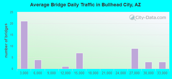
- 566,108Total average daily traffic
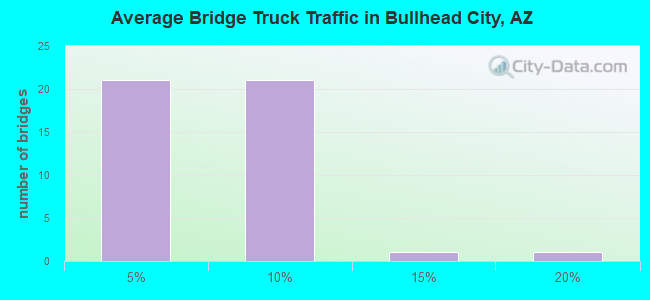
- 29,883Total average daily truck traffic
- 583,217Total future (year 2034) average daily traffic
- National Bridge Inventory (NBI) Registered Bridges for Bullhead City
- No street view available for this location
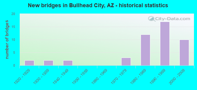
- New bridges - historical statistics
- 21920-1929
- 21930-1939
- 21940-1949
- 31970-1979
- 121980-1989
- 171990-1999
- 102000-2009
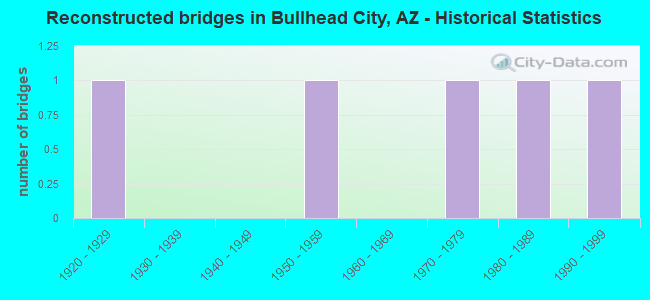
- Reconstructed bridges - Historical Statistics
- 11920-1929
- 01930-1939
- 01940-1949
- 11950-1959
- 01960-1969
- 11970-1979
- 11980-1989
- 11990-1999
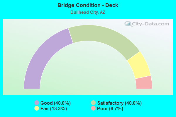
- Bridge Condition - Deck
- 40.0%Good
- 40.0%Satisfactory
- 13.3%Fair
- 6.7%Poor
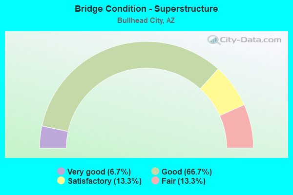
- Bridge Condition - Superstructure
- 6.7%Very good
- 66.7%Good
- 13.3%Satisfactory
- 13.3%Fair
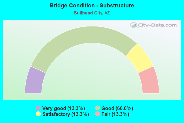
- Bridge Condition - Substructure
- 13.3%Very good
- 60.0%Good
- 13.3%Satisfactory
- 13.3%Fair
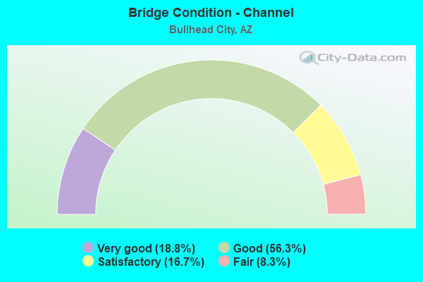
- Bridge Condition - Channel
- 18.8%Very good
- 56.3%Good
- 16.7%Satisfactory
- 8.3%Fair
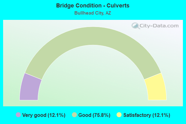
- Bridge Condition - Culverts
- 12.1%Very good
- 75.8%Good
- 12.1%Satisfactory
Find on map >> Show street view
Structure Number: 10701, Location: 250 ft S Laughlin View Dr (Lat: 35.165667, Lng: -114.545278), Route carried "on" structure: City street , Year Built: 2007, Status: Open, Structure Length: 3.05m (10.01ft), Average Daily Traffic: 100 (year 2020), Truck Traffic: 1%, Average Future Daily Traffic: 110 (year 2040), Design Load: HS 20, Features Intersected: Drainage Channel, Facility Carried by Structure: Bridge Way
Minimum Vertical Clearance: 4.21m (13.81ft), Kilometerpoint: 0.000, Lanes on structure: 2, Owner: City or Municipal Highway Agency, Approaching Roadway Width: 8.5m (27.9ft), Material/Design: Wood or Timber, Design/Construction: Stringer/Multi-beam, Number Of Spans In Main Unit: 6, Length of Maximum Span: 5.2m (17.1ft), Curb or Sidewalk Widths: Left: 2.2m (7.2ft), Right: 0.1m (0.3ft), Curb-To-Curb Width: 8.5m (27.9ft), Out-to-Out Width: 11.3m (37.1ft)
Condition: Deck: Good, Superstructure: Good, Substructure: Good, Channel: Good, Operating Rating: 33.6 metric tons, Method Used To Determine Operating Rating: Load Factor (LF), Inventory Rating: 24.5 metric tons, Method Used To Determine Inventory Rating: Load Factor (LF), Structural Evaluation: Equal to present minimum criteria, Deck Geometry: High priority of corrective action, Waterway Adequacy: Equal to present desirable criteria, Approach Roadway Alignment: Equal to present minimum criteria, Designated Inspection Frequency: Every 24 months, Inspection Date: June 2020, Deck Structure Type: Wood or Timber, Wearing Surface/Protective System: Wearing Surface: Wood or Timber
Find on map >> Show street view
Structure Number: 10702, Location: N Jct Laughlin Ranch Blvd (Lat: 35.136556, Lng: -114.539056), Route carried "on" structure: City street , Year Built: 2005, Status: Open, Structure Length: 3.66m (12.01ft), Average Daily Traffic: 1,200 (year 2020), Truck Traffic: 1%, Average Future Daily Traffic: 1,210 (year 2040), Design Load: HS 20, Features Intersected: Drainage Channel, Facility Carried by Structure: Riverport Drive
Minimum Vertical Clearance: 4.22m (13.85ft), Kilometerpoint: 0.000, Lanes on structure: 2, Owner: City or Municipal Highway Agency, Approaching Roadway Width: 8.8m (28.9ft), Material/Design: Wood or Timber, Design/Construction: Stringer/Multi-beam, Number Of Spans In Main Unit: 7, Length of Maximum Span: 6.1m (20.0ft), Curb or Sidewalk Widths: Left: 0.1m (0.3ft), Right: 2.5m (8.2ft), Curb-To-Curb Width: 8.7m (28.5ft), Out-to-Out Width: 11.8m (38.7ft)
Condition: Deck: Good, Superstructure: Good, Substructure: Good, Channel: Good, Operating Rating: 37.2 metric tons, Method Used To Determine Operating Rating: Allowable Stress (AS), Inventory Rating: 27.2 metric tons, Method Used To Determine Inventory Rating: Allowable Stress (AS), Structural Evaluation: Equal to present minimum criteria, Deck Geometry: High priority of corrective action, Waterway Adequacy: Equal to present desirable criteria, Approach Roadway Alignment: Equal to present minimum criteria, Designated Inspection Frequency: Every 24 months, Inspection Date: June 2020, Deck Structure Type: Wood or Timber, Wearing Surface/Protective System: Wearing Surface: Wood or Timber
Find on map >> Show street view
Structure Number: 11178, Location: 1.9 mi NW Jct SR 95 (Lat: 35.070611, Lng: -114.561833), Route carried "on" structure: City street , Year Built: 1991, Status: Open, Structure Length: 1.04m (3.41ft), Average Daily Traffic: 10,855 (year 2018), Truck Traffic: 2%, Average Future Daily Traffic: 10,865 (year 2036), Design Load: HS 20, Features Intersected: Fox Wash, Facility Carried by Structure: Bullhead Parkway
Minimum Vertical Clearance: 30+ m (98+ ft), Kilometerpoint: 3.058, Lanes on structure: 4, Owner: City or Municipal Highway Agency, Approaching Roadway Width: 20.7m (67.9ft), Skew: 22 degrees, Material/Design: Steel, Design/Construction: Culvert, Number Of Spans In Main Unit: 3, Length of Maximum Span: 2.4m (7.9ft)
Condition: Channel: Good, Culverts: Good, Operating Rating: 89.8 metric tons, Method Used To Determine Operating Rating: Load Factor (LF), Inventory Rating: 89.8 metric tons, Method Used To Determine Inventory Rating: Load Factor (LF), Structural Evaluation: Better than present minimum criteria, Waterway Adequacy: Equal to present desirable criteria, Approach Roadway Alignment: Equal to present desirable criteria, Designated Inspection Frequency: Every 48 months, Inspection Date: April 2020