Bridge Statistics for Brownsville, Texas (TX)
Condition, Traffic, Stress, Structural Evaluation, Project Costs
- National Bridge Inventory (NBI) Statistics
- 191Number of bridges
- 4,993ft / 1,522mTotal length
- $383,000Total costs
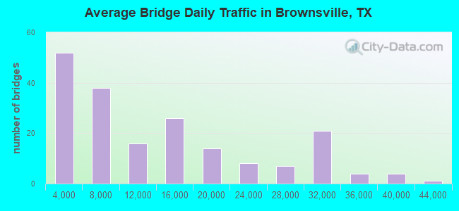
- 2,373,966Total average daily traffic
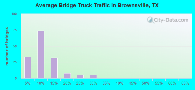
- 195,625Total average daily truck traffic
- National Bridge Inventory (NBI) Registered Bridges for Brownsville
- No street view available for this location
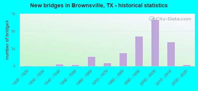
- New bridges - historical statistics
- 11920-1929
- 31940-1949
- 21950-1959
- 141960-1969
- 51970-1979
- 191980-1989
- 431990-1999
- 672000-2009
- 352010-2019
- 22020-2022
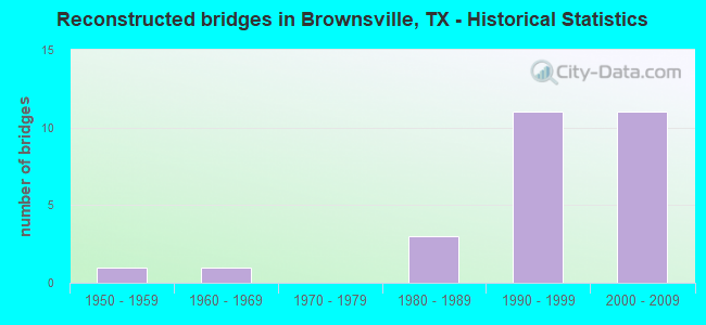
- Reconstructed bridges - Historical Statistics
- 11950-1959
- 11960-1969
- 01970-1979
- 31980-1989
- 111990-1999
- 112000-2009
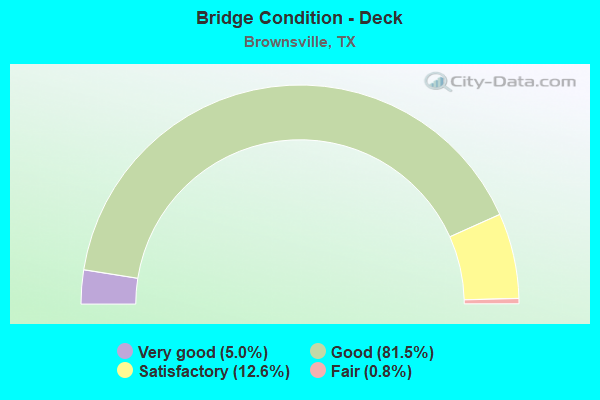
- Bridge Condition - Deck
- 5.0%Very good
- 81.5%Good
- 12.6%Satisfactory
- 0.8%Fair
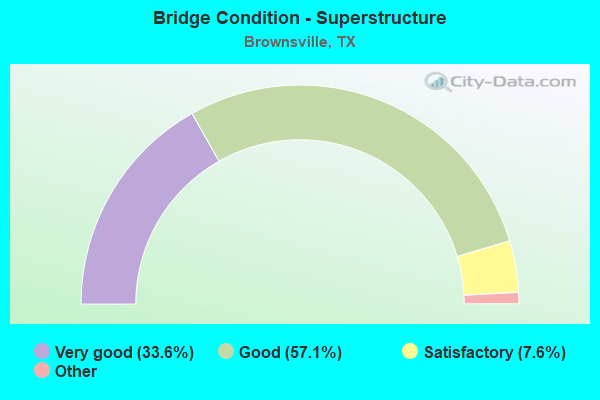
- Bridge Condition - Superstructure
- 33.6%Excellent
- 57.1%Very good
- 7.6%Good
- 1.7%Satisfactory
- 0.8%Fair
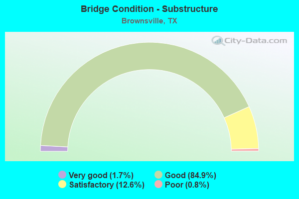
- Bridge Condition - Substructure
- 1.7%Very good
- 84.9%Good
- 12.6%Satisfactory
- 0.8%Poor
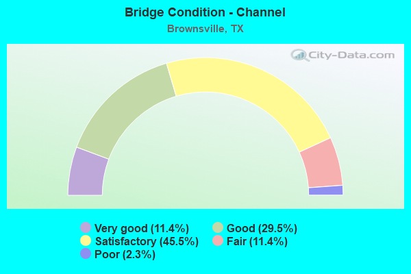
- Bridge Condition - Channel
- 11.4%Very good
- 29.5%Good
- 45.5%Satisfactory
- 11.4%Fair
- 2.3%Poor
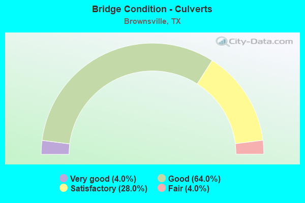
- Bridge Condition - Culverts
- 4.0%Very good
- 64.0%Good
- 28.0%Satisfactory
- 4.0%Fair
Find on map >> Show street view
Structure Number: 210310003906257, Location: 2.00 MI E OF FM 800 (Lat: 26.180200, Lng: -97.751294), Route carried "on" structure: Business State highway 83, Year Built: 1997, Status: Open, Structure Length: 1.13m (3.71ft), Average Daily Traffic: 10,700 (year 2017), Truck Traffic: 6%, Average Future Daily Traffic: 13,730 (year 2037), Design Load: HS 20, Features Intersected: DRAINAGE DITCH
Minimum Vertical Clearance: 30+ m (98+ ft), Kilometerpoint: 9.981, Lanes on structure: 5, Owner: State Highway Agency, Approaching Roadway Width: 19.8m (65.0ft), Material/Design: Concrete, Design/Construction: Culvert, Number Of Spans In Main Unit: 3, Length of Maximum Span: 3.0m (9.8ft)
Condition: Channel: Satisfactory, Culverts: Satisfactory, Operating Rating: 39.9 metric tons, Method Used To Determine Operating Rating: Load Factor (LF), Inventory Rating: 23.6 metric tons, Method Used To Determine Inventory Rating: Load Factor (LF), Structural Evaluation: Somewhat better than minimum adequacy, Waterway Adequacy: Equal to present minimum criteria, Approach Roadway Alignment: Equal to present desirable criteria, Designated Inspection Frequency: Every 48 months, Inspection Date: March 2021
Find on map >> Show street view
Structure Number: 210310003908019, Location: 2.30 Mi SE of SH 100 (Lat: 26.052892, Lng: -97.558628), Route carried "on" structure: US 77, Year Built: 1924, Year Reconstructed: 1987, Status: Open, Structure Length: 0.76m (2.49ft), Average Daily Traffic: 41,850 (year 2011), Truck Traffic: 9%, Average Future Daily Traffic: 61,350 (year 2031), Features Intersected: Jackass Prairie Creek
Minimum Vertical Clearance: 30+ m (98+ ft), Kilometerpoint: 42.735, Lanes on structure: 11, Owner: State Highway Agency, Approaching Roadway Width: 63.1m (207.0ft), Skew: 22 degrees, Material/Design: Concrete, Design/Construction: Culvert, Number Of Spans In Main Unit: 2, Length of Maximum Span: 3.0m (9.8ft)
Condition: Channel: Satisfactory, Culverts: Satisfactory, Operating Rating: 32.7 metric tons, Method Used To Determine Operating Rating: Field evaluation and documented engineering judgment, Inventory Rating: 24.5 metric tons, Method Used To Determine Inventory Rating: Field evaluation and documented engineering judgment, Structural Evaluation: Equal to present minimum criteria, Waterway Adequacy: Equal to present minimum criteria, Approach Roadway Alignment: Equal to present desirable criteria, Designated Inspection Frequency: Every 24 months, Inspection Date: March 2021
Find on map >> Show street view
Structure Number: 210310003908021, Location: 1.20 Mi NW of FM 511 (Lat: 26.042656, Lng: -97.547058), Route carried "on" structure: US 77, Year Built: 2007, Status: Open, Structure Length: 8.29m (27.20ft), Average Daily Traffic: 21,780 (year 2011), Truck Traffic: 9%, Average Future Daily Traffic: 31,920 (year 2031), Design Load: HL 93, Features Intersected: Rancho Viejo Dr
Minimum Vertical Clearance: 30+ m (98+ ft), Kilometerpoint: 43.811, Lanes on structure: 3, Lanes under structure: 6, Owner: State Highway Agency, Approaching Roadway Width: 16.8m (55.1ft), Material/Design: Prestressed concrete, Design/Construction: Stringer/Multi-beam, Number Of Spans In Main Unit: 1, Number Of Approach Spans: 2, Length of Maximum Span: 34.1m (111.9ft), Curb-To-Curb Width: 17.0m (55.8ft), Out-to-Out Width: 17.7m (58.1ft)
Condition: Deck: Good, Superstructure: Good, Substructure: Good, Operating Rating: 54.4 metric tons, Method Used To Determine Operating Rating: Assigned ratings based on Load and Resistance Factor Design (LRFD) reported in metric tons, Inventory Rating: 32.7 metric tons, Method Used To Determine Inventory Rating: Assigned ratings based on Load and Resistance Factor Design (LRFD) reported in metric tons, Structural Evaluation: Better than present minimum criteria, Deck Geometry: Equal to present minimum criteria, Underclear: Superior to present desirable criteria, Approach Roadway Alignment: Equal to present desirable criteria, Designated Inspection Frequency: Every 24 months, Inspection Date: March 2021, Deck Structure Type: Concrete Precast Panels
Find on map >> Show street view
Structure Number: 210310003908224, Location: 1.05 MI NW OF SH 100 (Lat: 26.093989, Lng: -97.589606), Route carried "on" structure: US 77, Year Built: 1983, Year Reconstructed: 2005, Status: Open, Structure Length: 4.57m (14.99ft), Average Daily Traffic: 25,180 (year 2011), Truck Traffic: 8%, Average Future Daily Traffic: 35,250 (year 2031), Design Load: HS 20, Features Intersected: RUNNELS ST (FR T/A)
Minimum Vertical Clearance: 30+ m (98+ ft), Kilometerpoint: 36.682, Lanes on structure: 3, Lanes under structure: 2, Owner: State Highway Agency, Approaching Roadway Width: 16.8m (55.1ft), Material/Design: Prestressed concrete, Design/Construction: Stringer/Multi-beam, Number Of Spans In Main Unit: 3, Length of Maximum Span: 18.3m (60.0ft), Curb-To-Curb Width: 16.7m (54.8ft), Out-to-Out Width: 17.3m (56.8ft)
Condition: Deck: Satisfactory, Superstructure: Good, Substructure: Good, Operating Rating: 54.4 metric tons, Method Used To Determine Operating Rating: Assigned rating based on Load Factor Design (LFD) reported in metric tons, Inventory Rating: 32.7 metric tons, Method Used To Determine Inventory Rating: Assigned rating based on Load Factor Design (LFD) reported in metric tons, Structural Evaluation: Better than present minimum criteria, Deck Geometry: Equal to present minimum criteria, Underclear: Meets minimum limits, Approach Roadway Alignment: Equal to present desirable criteria, Designated Inspection Frequency: Every 24 months, Inspection Date: Febuary 2021, Deck Structure Type: Concrete Cast-file-Place
Find on map >> Show street view
Structure Number: 210310003908225, Location: 1.05 MI NW OF SH 100 (Lat: 26.094158, Lng: -97.590092), Route carried "on" structure: US 77, Year Built: 1983, Year Reconstructed: 2005, Status: Open, Structure Length: 4.57m (14.99ft), Average Daily Traffic: 25,180 (year 2011), Truck Traffic: 8%, Average Future Daily Traffic: 35,250 (year 2031), Design Load: HS 20, Features Intersected: RUNNELS ST (FR T/A)
Minimum Vertical Clearance: 30+ m (98+ ft), Kilometerpoint: 36.682, Lanes on structure: 3, Lanes under structure: 2, Owner: State Highway Agency, Approaching Roadway Width: 16.8m (55.1ft), Material/Design: Prestressed concrete, Design/Construction: Stringer/Multi-beam, Number Of Spans In Main Unit: 3, Length of Maximum Span: 18.3m (60.0ft), Curb-To-Curb Width: 16.8m (55.1ft), Out-to-Out Width: 17.3m (56.8ft)
Condition: Deck: Satisfactory, Superstructure: Good, Substructure: Good, Operating Rating: 54.4 metric tons, Method Used To Determine Operating Rating: Assigned rating based on Load Factor Design (LFD) reported in metric tons, Inventory Rating: 32.7 metric tons, Method Used To Determine Inventory Rating: Assigned rating based on Load Factor Design (LFD) reported in metric tons, Structural Evaluation: Better than present minimum criteria, Deck Geometry: Equal to present minimum criteria, Underclear: Meets minimum limits, Approach Roadway Alignment: Equal to present desirable criteria, Designated Inspection Frequency: Every 24 months, Inspection Date: Febuary 2021, Deck Structure Type: Concrete Cast-file-Place
Find on map >> Show street view
Structure Number: 210310003908226, Location: 0.90 Mi N of FM 1732 (Lat: 26.029128, Lng: -97.533356), Route carried "on" structure: US 77, Year Built: 1987, Year Reconstructed: 2007, Status: Open, Structure Length: 6.10m (20.01ft), Average Daily Traffic: 21,780 (year 2011), Truck Traffic: 9%, Average Future Daily Traffic: 31,920 (year 2031), Design Load: HS 20, Features Intersected: FM 511
Minimum Vertical Clearance: 30+ m (98+ ft), Kilometerpoint: 45.800, Lanes on structure: 3, Lanes under structure: 4, Owner: State Highway Agency, Approaching Roadway Width: 16.8m (55.1ft), Skew: 4 degrees, Material/Design: Prestressed concrete, Design/Construction: Stringer/Multi-beam, Number Of Spans In Main Unit: 4, Length of Maximum Span: 15.2m (49.9ft), Curb-To-Curb Width: 16.6m (54.5ft), Out-to-Out Width: 17.4m (57.1ft)
Condition: Deck: Satisfactory, Superstructure: Good, Substructure: Good, Operating Rating: 54.4 metric tons, Method Used To Determine Operating Rating: Assigned rating based on Load Factor Design (LFD) reported in metric tons, Inventory Rating: 32.7 metric tons, Method Used To Determine Inventory Rating: Assigned rating based on Load Factor Design (LFD) reported in metric tons, Structural Evaluation: Better than present minimum criteria, Deck Geometry: Equal to present minimum criteria, Underclear: High priority of corrective action, Approach Roadway Alignment: Equal to present desirable criteria, Designated Inspection Frequency: Every 24 months, Inspection Date: March 2021, Deck Structure Type: Concrete Cast-file-Place
Find on map >> Show street view
Structure Number: 210310003908227, Location: 0.90 Mi N of FM 1732 (Lat: 26.029142, Lng: -97.533253), Route carried "on" structure: US 77, Year Built: 1987, Year Reconstructed: 2007, Status: Open, Structure Length: 6.10m (20.01ft), Average Daily Traffic: 21,780 (year 2011), Truck Traffic: 9%, Average Future Daily Traffic: 31,920 (year 2031), Design Load: HS 20, Features Intersected: FM 511
Minimum Vertical Clearance: 30+ m (98+ ft), Kilometerpoint: 45.800, Lanes on structure: 3, Lanes under structure: 4, Owner: State Highway Agency, Approaching Roadway Width: 16.8m (55.1ft), Skew: 4 degrees, Material/Design: Prestressed concrete, Design/Construction: Stringer/Multi-beam, Number Of Spans In Main Unit: 4, Length of Maximum Span: 15.2m (49.9ft), Curb-To-Curb Width: 16.6m (54.5ft), Out-to-Out Width: 17.4m (57.1ft)
Condition: Deck: Satisfactory, Superstructure: Good, Substructure: Good, Operating Rating: 54.4 metric tons, Method Used To Determine Operating Rating: Assigned rating based on Load Factor Design (LFD) reported in metric tons, Inventory Rating: 32.7 metric tons, Method Used To Determine Inventory Rating: Assigned rating based on Load Factor Design (LFD) reported in metric tons, Structural Evaluation: Better than present minimum criteria, Deck Geometry: Equal to present minimum criteria, Underclear: High priority of corrective action, Approach Roadway Alignment: Equal to present desirable criteria, Designated Inspection Frequency: Every 24 months, Inspection Date: March 2021, Deck Structure Type: Concrete Cast-file-Place
Find on map >> Show street view
Structure Number: 210310003908232, Location: 1.20 MI SE OF SH 100 (Lat: 26.067292, Lng: -97.570067), Route carried "on" structure: US 77, Year Built: 1990, Year Reconstructed: 2007, Status: Open, Structure Length: 4.72m (15.49ft), Average Daily Traffic: 18,520 (year 2015), Truck Traffic: 9%, Average Future Daily Traffic: 31,550 (year 2035), Design Load: HS 20, Features Intersected: ROBERTA RD
Minimum Vertical Clearance: 30+ m (98+ ft), Kilometerpoint: 40.226, Lanes on structure: 3, Lanes under structure: 2, Owner: State Highway Agency, Approaching Roadway Width: 16.8m (55.1ft), Material/Design: Prestressed concrete, Design/Construction: Stringer/Multi-beam, Number Of Spans In Main Unit: 1, Number Of Approach Spans: 2, Length of Maximum Span: 19.8m (65.0ft), Curb-To-Curb Width: 16.6m (54.5ft), Out-to-Out Width: 17.4m (57.1ft)
Condition: Deck: Satisfactory, Superstructure: Good, Substructure: Good, Operating Rating: 54.4 metric tons, Method Used To Determine Operating Rating: Assigned rating based on Load Factor Design (LFD) reported in metric tons, Inventory Rating: 32.7 metric tons, Method Used To Determine Inventory Rating: Assigned rating based on Load Factor Design (LFD) reported in metric tons, Structural Evaluation: Better than present minimum criteria, Deck Geometry: Equal to present desirable criteria, Underclear: Superior to present desirable criteria, Approach Roadway Alignment: Equal to present desirable criteria, Designated Inspection Frequency: Every 24 months, Inspection Date: Febuary 2021, Deck Structure Type: Concrete Precast Panels
Find on map >> Show street view
Structure Number: 210310003908233, Location: 1.20 MI SE OF SH 100 (Lat: 26.067483, Lng: -97.570547), Route carried "on" structure: US 77, Year Built: 1990, Year Reconstructed: 2007, Status: Open, Structure Length: 4.72m (15.49ft), Average Daily Traffic: 18,520 (year 2015), Truck Traffic: 9%, Average Future Daily Traffic: 31,550 (year 2035), Design Load: HS 20, Features Intersected: ROBERTA RD
Minimum Vertical Clearance: 30+ m (98+ ft), Kilometerpoint: 40.226, Lanes on structure: 3, Lanes under structure: 2, Owner: State Highway Agency, Approaching Roadway Width: 16.8m (55.1ft), Material/Design: Prestressed concrete, Design/Construction: Stringer/Multi-beam, Number Of Spans In Main Unit: 1, Number Of Approach Spans: 2, Length of Maximum Span: 19.8m (65.0ft), Curb-To-Curb Width: 16.7m (54.8ft), Out-to-Out Width: 17.4m (57.1ft)
Condition: Deck: Satisfactory, Superstructure: Good, Substructure: Good, Operating Rating: 54.4 metric tons, Method Used To Determine Operating Rating: Assigned rating based on Load Factor Design (LFD) reported in metric tons, Inventory Rating: 32.7 metric tons, Method Used To Determine Inventory Rating: Assigned rating based on Load Factor Design (LFD) reported in metric tons, Structural Evaluation: Better than present minimum criteria, Deck Geometry: Superior to present desirable criteria, Underclear: Superior to present desirable criteria, Approach Roadway Alignment: Equal to present desirable criteria, Designated Inspection Frequency: Every 24 months, Inspection Date: Febuary 2021, Deck Structure Type: Concrete Precast Panels
Find on map >> Show street view
Structure Number: 210310003908239, Location: 0.85 Mi N of FM 3248 (Lat: 25.990469, Lng: -97.520783), Route carried "on" structure: US 77, Year Built: 1991, Year Reconstructed: 2004, Status: Open, Structure Length: 8.69m (28.51ft), Average Daily Traffic: 30,810 (year 2011), Truck Traffic: 8%, Average Future Daily Traffic: 55,840 (year 2031), Design Load: HS 20, Features Intersected: Old Alice Rd
Minimum Vertical Clearance: 30+ m (98+ ft), Kilometerpoint: 50.482, Lanes on structure: 3, Lanes under structure: 6, Owner: State Highway Agency, Approaching Roadway Width: 16.8m (55.1ft), Material/Design: Prestressed concrete, Design/Construction: Stringer/Multi-beam, Number Of Spans In Main Unit: 3, Length of Maximum Span: 29.0m (95.1ft), Curb-To-Curb Width: 16.6m (54.5ft), Out-to-Out Width: 17.7m (58.1ft)
Condition: Deck: Good, Superstructure: Very good, Substructure: Good, Operating Rating: 54.4 metric tons, Method Used To Determine Operating Rating: Assigned rating based on Load Factor Design (LFD) reported in metric tons, Inventory Rating: 32.7 metric tons, Method Used To Determine Inventory Rating: Assigned rating based on Load Factor Design (LFD) reported in metric tons, Structural Evaluation: Better than present minimum criteria, Deck Geometry: Equal to present minimum criteria, Underclear: Superior to present desirable criteria, Approach Roadway Alignment: Equal to present desirable criteria, Designated Inspection Frequency: Every 24 months, Inspection Date: March 2021, Deck Structure Type: Concrete Precast Panels
Find on map >> Show street view
Structure Number: 21031000390824, Location: 0.85 Mi N of FM 3248 (Lat: 25.990431, Lng: -97.520883), Route carried "on" structure: US 77, Year Built: 1991, Year Reconstructed: 2004, Status: Open, Structure Length: 8.69m (28.51ft), Average Daily Traffic: 30,810 (year 2011), Truck Traffic: 8%, Average Future Daily Traffic: 55,840 (year 2031), Design Load: HS 20, Features Intersected: Old Alice Rd
Minimum Vertical Clearance: 30+ m (98+ ft), Kilometerpoint: 50.482, Lanes on structure: 3, Lanes under structure: 6, Owner: State Highway Agency, Approaching Roadway Width: 16.8m (55.1ft), Material/Design: Prestressed concrete, Design/Construction: Stringer/Multi-beam, Number Of Spans In Main Unit: 3, Length of Maximum Span: 29.0m (95.1ft), Curb-To-Curb Width: 16.6m (54.5ft), Out-to-Out Width: 17.1m (56.1ft)
Condition: Deck: Good, Superstructure: Very good, Substructure: Good, Operating Rating: 54.4 metric tons, Method Used To Determine Operating Rating: Assigned rating based on Load Factor Design (LFD) reported in metric tons, Inventory Rating: 32.7 metric tons, Method Used To Determine Inventory Rating: Assigned rating based on Load Factor Design (LFD) reported in metric tons, Structural Evaluation: Better than present minimum criteria, Deck Geometry: Equal to present minimum criteria, Underclear: Superior to present desirable criteria, Approach Roadway Alignment: Equal to present desirable criteria, Designated Inspection Frequency: Every 24 months, Inspection Date: March 2021, Deck Structure Type: Concrete Precast Panels
Find on map >> Show street view
Structure Number: 210310003908241, Location: 0.80 Mi S of FM 1732 (Lat: 26.004422, Lng: -97.529844), Route carried "on" structure: US 77, Year Built: 1991, Year Reconstructed: 2004, Status: Open, Structure Length: 5.33m (17.49ft), Average Daily Traffic: 30,810 (year 2011), Truck Traffic: 8%, Average Future Daily Traffic: 55,840 (year 2031), Design Load: HS 20, Features Intersected: Merryman Rd
Minimum Vertical Clearance: 30+ m (98+ ft), Kilometerpoint: 48.681, Lanes on structure: 3, Lanes under structure: 4, Owner: State Highway Agency, Approaching Roadway Width: 16.8m (55.1ft), Material/Design: Prestressed concrete, Design/Construction: Stringer/Multi-beam, Number Of Spans In Main Unit: 3, Length of Maximum Span: 19.8m (65.0ft), Curb-To-Curb Width: 16.6m (54.5ft), Out-to-Out Width: 17.7m (58.1ft)
Condition: Deck: Good, Superstructure: Very good, Substructure: Good, Operating Rating: 54.4 metric tons, Method Used To Determine Operating Rating: Assigned rating based on Load Factor Design (LFD) reported in metric tons, Inventory Rating: 32.7 metric tons, Method Used To Determine Inventory Rating: Assigned rating based on Load Factor Design (LFD) reported in metric tons, Structural Evaluation: Better than present minimum criteria, Deck Geometry: Equal to present minimum criteria, Underclear: Superior to present desirable criteria, Approach Roadway Alignment: Equal to present desirable criteria, Designated Inspection Frequency: Every 24 months, Inspection Date: March 2021, Deck Structure Type: Concrete Precast Panels
Find on map >> Show street view
Structure Number: 210310003908242, Location: 0.80 Mi S of FM 1732 (Lat: 26.004422, Lng: -97.529956), Route carried "on" structure: US 77, Year Built: 1991, Year Reconstructed: 2004, Status: Open, Structure Length: 5.33m (17.49ft), Average Daily Traffic: 30,810 (year 2011), Truck Traffic: 8%, Average Future Daily Traffic: 55,840 (year 2031), Design Load: HS 20, Features Intersected: Merryman Rd
Minimum Vertical Clearance: 30+ m (98+ ft), Kilometerpoint: 48.681, Lanes on structure: 3, Lanes under structure: 4, Owner: State Highway Agency, Approaching Roadway Width: 16.8m (55.1ft), Material/Design: Prestressed concrete, Design/Construction: Stringer/Multi-beam, Number Of Spans In Main Unit: 3, Length of Maximum Span: 19.8m (65.0ft), Curb-To-Curb Width: 16.6m (54.5ft), Out-to-Out Width: 17.7m (58.1ft)
Condition: Deck: Good, Superstructure: Very good, Substructure: Good, Operating Rating: 54.4 metric tons, Method Used To Determine Operating Rating: Assigned rating based on Load Factor Design (LFD) reported in metric tons, Inventory Rating: 32.7 metric tons, Method Used To Determine Inventory Rating: Assigned rating based on Load Factor Design (LFD) reported in metric tons, Structural Evaluation: Better than present minimum criteria, Deck Geometry: Equal to present minimum criteria, Underclear: Superior to present desirable criteria, Approach Roadway Alignment: Equal to present desirable criteria, Designated Inspection Frequency: Every 24 months, Inspection Date: March 2021, Deck Structure Type: Concrete Precast Panels
Find on map >> Show street view
Structure Number: 210310003908243, Location: 0.90 Mi S of FM 511 (Lat: 26.016319, Lng: -97.530231), Route carried "on" structure: US 77, Year Built: 1991, Year Reconstructed: 2004, Status: Open, Structure Length: 6.25m (20.51ft), Average Daily Traffic: 30,810 (year 2011), Truck Traffic: 8%, Average Future Daily Traffic: 55,840 (year 2031), Design Load: HS 20, Features Intersected: FM 1732 (Anacua St)
Minimum Vertical Clearance: 30+ m (98+ ft), Kilometerpoint: 47.342, Lanes on structure: 3, Lanes under structure: 4, Owner: State Highway Agency, Approaching Roadway Width: 16.8m (55.1ft), Material/Design: Prestressed concrete, Design/Construction: Stringer/Multi-beam, Number Of Spans In Main Unit: 1, Number Of Approach Spans: 2, Length of Maximum Span: 25.9m (85.0ft), Curb-To-Curb Width: 16.6m (54.5ft), Out-to-Out Width: 17.7m (58.1ft)
Condition: Deck: Good, Superstructure: Good, Substructure: Good, Operating Rating: 54.4 metric tons, Method Used To Determine Operating Rating: Assigned rating based on Load Factor Design (LFD) reported in metric tons, Inventory Rating: 32.7 metric tons, Method Used To Determine Inventory Rating: Assigned rating based on Load Factor Design (LFD) reported in metric tons, Structural Evaluation: Better than present minimum criteria, Deck Geometry: Equal to present minimum criteria, Underclear: Superior to present desirable criteria, Approach Roadway Alignment: Equal to present desirable criteria, Designated Inspection Frequency: Every 24 months, Inspection Date: March 2021, Deck Structure Type: Concrete Precast Panels
Find on map >> Show street view
Structure Number: 210310003908244, Location: 0.90 Mi S of FM 511 (Lat: 26.016319, Lng: -97.530344), Route carried "on" structure: US 77, Year Built: 1991, Year Reconstructed: 2004, Status: Open, Structure Length: 6.25m (20.51ft), Average Daily Traffic: 30,810 (year 2011), Truck Traffic: 8%, Average Future Daily Traffic: 55,840 (year 2031), Design Load: HS 20, Features Intersected: FM 1732 (Anacua St)
Minimum Vertical Clearance: 30+ m (98+ ft), Kilometerpoint: 47.342, Lanes on structure: 3, Lanes under structure: 4, Owner: State Highway Agency, Approaching Roadway Width: 16.8m (55.1ft), Material/Design: Prestressed concrete, Design/Construction: Stringer/Multi-beam, Number Of Spans In Main Unit: 1, Number Of Approach Spans: 2, Length of Maximum Span: 25.9m (85.0ft), Curb-To-Curb Width: 16.6m (54.5ft), Out-to-Out Width: 17.1m (56.1ft)
Condition: Deck: Good, Superstructure: Very good, Substructure: Good, Operating Rating: 54.4 metric tons, Method Used To Determine Operating Rating: Assigned rating based on Load Factor Design (LFD) reported in metric tons, Inventory Rating: 32.7 metric tons, Method Used To Determine Inventory Rating: Assigned rating based on Load Factor Design (LFD) reported in metric tons, Structural Evaluation: Better than present minimum criteria, Deck Geometry: Equal to present minimum criteria, Underclear: Superior to present desirable criteria, Approach Roadway Alignment: Equal to present desirable criteria, Designated Inspection Frequency: Every 24 months, Inspection Date: March 2021, Deck Structure Type: Concrete Precast Panels
Find on map >> Show street view
Structure Number: 210310003908294, Location: 1.40 Mi S of FM 1732 (Lat: 25.996944, Lng: -97.525175), Route carried "on" structure: US 77, Year Built: 2000, Status: Open, Structure Length: 7.32m (24.02ft), Average Daily Traffic: 30,810 (year 2011), Truck Traffic: 8%, Average Future Daily Traffic: 55,840 (year 2031), Design Load: HS 20, Features Intersected: UP RR
Minimum Vertical Clearance: 30+ m (98+ ft), Kilometerpoint: 49.663, Lanes on structure: 3, Owner: State Highway Agency, Approaching Roadway Width: 17.1m (56.1ft), Skew: 9 degrees, Material/Design: Prestressed concrete, Design/Construction: Stringer/Multi-beam, Number Of Spans In Main Unit: 3, Length of Maximum Span: 27.4m (89.9ft), Curb-To-Curb Width: 17.0m (55.8ft), Out-to-Out Width: 17.7m (58.1ft)
Condition: Deck: Good, Superstructure: Very good, Substructure: Good, Operating Rating: 54.4 metric tons, Method Used To Determine Operating Rating: Assigned rating based on Load Factor Design (LFD) reported in metric tons, Inventory Rating: 32.7 metric tons, Method Used To Determine Inventory Rating: Assigned rating based on Load Factor Design (LFD) reported in metric tons, Structural Evaluation: Better than present minimum criteria, Deck Geometry: Equal to present minimum criteria, Underclear: Superior to present desirable criteria, Approach Roadway Alignment: Equal to present desirable criteria, Designated Inspection Frequency: Every 24 months, Inspection Date: March 2021, Deck Structure Type: Concrete Precast Panels
Find on map >> Show street view
Structure Number: 210310003908295, Location: 1.40 MI S OF FM 1732 (Lat: 25.997050, Lng: -97.525492), Route carried "on" structure: US 77, Year Built: 2000, Status: Open, Structure Length: 7.32m (24.02ft), Average Daily Traffic: 30,810 (year 2011), Truck Traffic: 8%, Average Future Daily Traffic: 55,840 (year 2031), Design Load: HS 20, Features Intersected: UP RR
Minimum Vertical Clearance: 30+ m (98+ ft), Kilometerpoint: 49.663, Lanes on structure: 3, Owner: State Highway Agency, Approaching Roadway Width: 17.1m (56.1ft), Skew: 9 degrees, Material/Design: Prestressed concrete, Design/Construction: Stringer/Multi-beam, Number Of Spans In Main Unit: 3, Length of Maximum Span: 27.4m (89.9ft), Curb-To-Curb Width: 17.0m (55.8ft), Out-to-Out Width: 17.7m (58.1ft)
Condition: Deck: Good, Superstructure: Very good, Substructure: Good, Operating Rating: 54.4 metric tons, Method Used To Determine Operating Rating: Assigned rating based on Load Factor Design (LFD) reported in metric tons, Inventory Rating: 32.7 metric tons, Method Used To Determine Inventory Rating: Assigned rating based on Load Factor Design (LFD) reported in metric tons, Structural Evaluation: Better than present minimum criteria, Deck Geometry: Equal to present minimum criteria, Underclear: Superior to present desirable criteria, Approach Roadway Alignment: Equal to present desirable criteria, Designated Inspection Frequency: Every 24 months, Inspection Date: March 2021, Deck Structure Type: Concrete Precast Panels
Find on map >> Show street view
Structure Number: 210310003908353, Location: 1.20 Mi NW of FM 511 (Lat: 26.042578, Lng: -97.547133), Route carried "on" structure: US 77, Year Built: 2007, Status: Open, Structure Length: 8.29m (27.20ft), Average Daily Traffic: 22,300 (year 2015), Truck Traffic: 9%, Average Future Daily Traffic: 34,510 (year 2035), Design Load: HL 93, Features Intersected: Rancho Viejo Dr
Minimum Vertical Clearance: 30+ m (98+ ft), Kilometerpoint: 45.850, Lanes on structure: 3, Lanes under structure: 6, Owner: State Highway Agency, Approaching Roadway Width: 16.8m (55.1ft), Material/Design: Prestressed concrete, Design/Construction: Stringer/Multi-beam, Number Of Spans In Main Unit: 1, Number Of Approach Spans: 2, Length of Maximum Span: 34.1m (111.9ft), Curb-To-Curb Width: 17.0m (55.8ft), Out-to-Out Width: 17.7m (58.1ft)
Condition: Deck: Good, Superstructure: Good, Substructure: Good, Operating Rating: 54.4 metric tons, Method Used To Determine Operating Rating: Assigned ratings based on Load and Resistance Factor Design (LRFD) reported in metric tons, Inventory Rating: 32.7 metric tons, Method Used To Determine Inventory Rating: Assigned ratings based on Load and Resistance Factor Design (LRFD) reported in metric tons, Structural Evaluation: Better than present minimum criteria, Deck Geometry: Equal to present minimum criteria, Underclear: Superior to present desirable criteria, Approach Roadway Alignment: Equal to present desirable criteria, Designated Inspection Frequency: Every 24 months, Inspection Date: March 2021, Deck Structure Type: Concrete Precast Panels
Find on map >> Show street view
Structure Number: 210310003908354, Location: 2.05 Mi SE of SH 100 (Lat: 26.056197, Lng: -97.562244), Route carried "on" structure: US 77, Year Built: 2007, Status: Open, Structure Length: 6.86m (22.51ft), Average Daily Traffic: 20,920 (year 2011), Truck Traffic: 9%, Average Future Daily Traffic: 30,670 (year 2031), Design Load: HL 93, Features Intersected: Carmen Rd
Minimum Vertical Clearance: 30+ m (98+ ft), Kilometerpoint: 41.698, Lanes on structure: 3, Lanes under structure: 2, Owner: State Highway Agency, Approaching Roadway Width: 17.1m (56.1ft), Material/Design: Prestressed concrete, Design/Construction: Stringer/Multi-beam, Number Of Spans In Main Unit: 1, Number Of Approach Spans: 2, Length of Maximum Span: 29.0m (95.1ft), Curb-To-Curb Width: 17.0m (55.8ft), Out-to-Out Width: 17.7m (58.1ft)
Condition: Deck: Good, Superstructure: Very good, Substructure: Good, Operating Rating: 54.4 metric tons, Method Used To Determine Operating Rating: Assigned ratings based on Load and Resistance Factor Design (LRFD) reported in metric tons, Inventory Rating: 32.7 metric tons, Method Used To Determine Inventory Rating: Assigned ratings based on Load and Resistance Factor Design (LRFD) reported in metric tons, Structural Evaluation: Better than present minimum criteria, Deck Geometry: Equal to present minimum criteria, Underclear: Superior to present desirable criteria, Approach Roadway Alignment: Equal to present desirable criteria, Designated Inspection Frequency: Every 24 months, Inspection Date: March 2021, Deck Structure Type: Concrete Precast Panels
Find on map >> Show street view
Structure Number: 210310003908355, Location: 2.05 Mi SE of SH 100 (Lat: 26.056131, Lng: -97.562306), Route carried "on" structure: US 77, Year Built: 2007, Status: Open, Structure Length: 6.86m (22.51ft), Average Daily Traffic: 20,920 (year 2011), Truck Traffic: 9%, Average Future Daily Traffic: 30,670 (year 2031), Design Load: HL 93, Features Intersected: Carmen Rd
Minimum Vertical Clearance: 30+ m (98+ ft), Kilometerpoint: 40.226, Lanes on structure: 3, Lanes under structure: 2, Owner: State Highway Agency, Approaching Roadway Width: 17.1m (56.1ft), Material/Design: Prestressed concrete, Design/Construction: Stringer/Multi-beam, Number Of Spans In Main Unit: 1, Number Of Approach Spans: 2, Length of Maximum Span: 29.0m (95.1ft), Curb-To-Curb Width: 17.0m (55.8ft), Out-to-Out Width: 17.7m (58.1ft)
Condition: Deck: Good, Superstructure: Very good, Substructure: Good, Operating Rating: 54.4 metric tons, Method Used To Determine Operating Rating: Assigned ratings based on Load and Resistance Factor Design (LRFD) reported in metric tons, Inventory Rating: 32.7 metric tons, Method Used To Determine Inventory Rating: Assigned ratings based on Load and Resistance Factor Design (LRFD) reported in metric tons, Structural Evaluation: Better than present minimum criteria, Deck Geometry: Equal to present minimum criteria, Underclear: Superior to present desirable criteria, Approach Roadway Alignment: Equal to present desirable criteria, Designated Inspection Frequency: Every 24 months, Inspection Date: March 2021, Deck Structure Type: Concrete Precast Panels
Find on map >> Show street view
Structure Number: 210310003908388, Location: 2.70 Mi SE of FM 732 (Lat: 26.081131, Lng: -97.580175), Route carried "on" structure: US 77, Year Built: 2006, Status: Open, Structure Length: 7.86m (25.79ft), Average Daily Traffic: 25,180 (year 2011), Truck Traffic: 8%, Average Future Daily Traffic: 35,250 (year 2031), Design Load: HS 25 or greater, Features Intersected: SH 100
Minimum Vertical Clearance: 30+ m (98+ ft), Kilometerpoint: 38.438, Lanes on structure: 3, Lanes under structure: 7, Owner: State Highway Agency, Approaching Roadway Width: 17.1m (56.1ft), Skew: 4 degrees, Material/Design: Prestressed concrete, Design/Construction: Stringer/Multi-beam, Number Of Spans In Main Unit: 1, Number Of Approach Spans: 2, Length of Maximum Span: 37.8m (124.0ft), Curb-To-Curb Width: 17.3m (56.8ft), Out-to-Out Width: 18.0m (59.1ft)
Condition: Deck: Good, Superstructure: Good, Substructure: Good, Operating Rating: 68.0 metric tons, Method Used To Determine Operating Rating: Assigned rating based on Load Factor Design (LFD) reported in metric tons, Inventory Rating: 40.8 metric tons, Method Used To Determine Inventory Rating: Assigned rating based on Load Factor Design (LFD) reported in metric tons, Structural Evaluation: Better than present minimum criteria, Deck Geometry: Better than present minimum criteria, Underclear: High priority of corrective action, Approach Roadway Alignment: Equal to present desirable criteria, Designated Inspection Frequency: Every 24 months, Inspection Date: March 2021, Deck Structure Type: Concrete Precast Panels
Find on map >> Show street view
Structure Number: 210310003908389, Location: 2.70 Mi SE of FM 732 (Lat: 26.080692, Lng: -97.579336), Route carried "on" structure: US 77, Year Built: 2006, Status: Open, Structure Length: 7.86m (25.79ft), Average Daily Traffic: 25,180 (year 2011), Truck Traffic: 8%, Average Future Daily Traffic: 35,250 (year 2031), Design Load: HS 25 or greater, Features Intersected: SH 100
Minimum Vertical Clearance: 30+ m (98+ ft), Kilometerpoint: 38.438, Lanes on structure: 3, Lanes under structure: 7, Owner: State Highway Agency, Approaching Roadway Width: 17.1m (56.1ft), Skew: 4 degrees, Material/Design: Prestressed concrete, Design/Construction: Stringer/Multi-beam, Number Of Spans In Main Unit: 1, Number Of Approach Spans: 2, Length of Maximum Span: 37.8m (124.0ft), Curb-To-Curb Width: 17.3m (56.8ft), Out-to-Out Width: 18.0m (59.1ft)
Condition: Deck: Good, Superstructure: Good, Substructure: Good, Operating Rating: 68.0 metric tons, Method Used To Determine Operating Rating: Assigned rating based on Load Factor Design (LFD) reported in metric tons, Inventory Rating: 40.8 metric tons, Method Used To Determine Inventory Rating: Assigned rating based on Load Factor Design (LFD) reported in metric tons, Structural Evaluation: Better than present minimum criteria, Deck Geometry: Better than present minimum criteria, Underclear: High priority of corrective action, Approach Roadway Alignment: Equal to present desirable criteria, Designated Inspection Frequency: Every 24 months, Inspection Date: March 2021, Deck Structure Type: Concrete Precast Panels
Find on map >> Show street view
Structure Number: 210310003908432, Location: IH69E/SH 550 INTERCHANG (Lat: 26.030550, Lng: -97.533850), Route carried "on" structure: Ramp Other road 550, Year Built: 2015, Status: Open, Structure Length: 30.48m (100.00ft), Average Daily Traffic: 16,835 (year 2013), Truck Traffic: 8%, Average Future Daily Traffic: 21,500 (year 2030), Design Load: HL 93, Features Intersected: IH 69E NB ENTRANCE
Minimum Vertical Clearance: 30+ m (98+ ft), Kilometerpoint: 0.000, Lanes on structure: 2, Lanes under structure: 2, Toll: On toll road, Owner: State Highway Agency, Approaching Roadway Width: 11.6m (38.1ft), Skew: 9 degrees, Material/Design: Prestressed concrete, Design/Construction: Stringer/Multi-beam, Number Of Spans In Main Unit: 9, Length of Maximum Span: 36.0m (118.1ft), Curb-To-Curb Width: 11.0m (36.1ft), Out-to-Out Width: 11.6m (38.1ft)
Condition: Deck: Good, Superstructure: Very good, Substructure: Good, Operating Rating: 54.4 metric tons, Method Used To Determine Operating Rating: Assigned ratings based on Load and Resistance Factor Design (LRFD) reported in metric tons, Inventory Rating: 32.7 metric tons, Method Used To Determine Inventory Rating: Assigned ratings based on Load and Resistance Factor Design (LRFD) reported in metric tons, Structural Evaluation: Better than present minimum criteria, Deck Geometry: Better than present minimum criteria, Underclear: Superior to present desirable criteria, Approach Roadway Alignment: Equal to present desirable criteria, Designated Inspection Frequency: Every 24 months, Inspection Date: May 2021, Deck Structure Type: Concrete Precast Panels
Find on map >> Show street view
Structure Number: 210310003908433, Location: I69E/SH550 INTERCHANGE (Lat: 26.029503, Lng: -97.532736), Route carried "on" structure: Ramp State highway 550, Year Built: 2015, Status: Open, Structure Length: 102.66m (336.81ft), Average Daily Traffic: 16,835 (year 2013), Truck Traffic: 8%, Average Future Daily Traffic: 21,500 (year 2030), Design Load: HL 93, Features Intersected: IH 69E
Minimum Vertical Clearance: 30+ m (98+ ft), Kilometerpoint: 0.000, Lanes on structure: 2, Lanes under structure: 14, Toll: On toll road, Owner: State Highway Agency, Approaching Roadway Width: 11.6m (38.1ft), Skew: 39 degrees, Material/Design: Steel continuous, Design/Construction: Stringer/Multi-beam, Number Of Spans In Main Unit: 3, Number Of Approach Spans: 25, Length of Maximum Span: 67.1m (220.1ft), Curb-To-Curb Width: 11.0m (36.1ft), Out-to-Out Width: 11.6m (38.1ft)
Condition: Deck: Good, Superstructure: Good, Substructure: Good, Channel: Very good, Operating Rating: 54.4 metric tons, Method Used To Determine Operating Rating: Assigned ratings based on Load and Resistance Factor Design (LRFD) reported in metric tons, Inventory Rating: 32.7 metric tons, Method Used To Determine Inventory Rating: Assigned ratings based on Load and Resistance Factor Design (LRFD) reported in metric tons, Structural Evaluation: Better than present minimum criteria, Deck Geometry: Better than present minimum criteria, Underclear: High priority of corrective action, Waterway Adequacy: Equal to present desirable criteria, Approach Roadway Alignment: Equal to present desirable criteria, Designated Inspection Frequency: Every 24 months, Inspection Date: May 2021, Deck Structure Type: Concrete Cast-file-Place
Find on map >> Show street view
Structure Number: 210310003908453, Location: 2.3 MI S OF I-169 (Lat: 25.997350, Lng: -97.525097), Route carried "on" structure: State highway 69, Year Built: 2020, Status: Open, Structure Length: 13.87m (45.51ft), Average Daily Traffic: 5,660 (year 2020), Truck Traffic: 10%, Average Future Daily Traffic: 1 (year 1900), Design Load: HL 93, Features Intersected: UPRR
Minimum Vertical Clearance: 30+ m (98+ ft), Kilometerpoint: 14.001, Lanes on structure: 1, Lanes under structure: 2, Owner: State Highway Agency, Approaching Roadway Width: 7.9m (25.9ft), Skew: 2 degrees, Material/Design: Prestressed concrete, Design/Construction: Stringer/Multi-beam, Number Of Spans In Main Unit: 2, Number Of Approach Spans: 3, Length of Maximum Span: 39.6m (129.9ft), Curb or Sidewalk Widths: Left: 0.0m, Right: 3.4m (11.2ft), Curb-To-Curb Width: 7.9m (25.9ft), Out-to-Out Width: 12.2m (40.0ft)
Condition: Deck: Good, Superstructure: Very good, Substructure: Very good, Operating Rating: 54.4 metric tons, Method Used To Determine Operating Rating: Assigned ratings based on Load and Resistance Factor Design (LRFD) reported in metric tons, Inventory Rating: 32.7 metric tons, Method Used To Determine Inventory Rating: Assigned ratings based on Load and Resistance Factor Design (LRFD) reported in metric tons, Structural Evaluation: Equal to present desirable criteria, Deck Geometry: High priority of corrective action, Underclear: Superior to present desirable criteria, Approach Roadway Alignment: Equal to present desirable criteria, Designated Inspection Frequency: Every 24 months, Inspection Date: March 2021, Deck Structure Type: Concrete Precast Panels
Find on map >> Show street view
Structure Number: 210310003908454, Location: 2.3 MI S OF I-169 (Lat: 25.997094, Lng: -97.525817), Route carried "on" structure: ServiceState highway 69, Year Built: 2020, Status: Open, Structure Length: 4.57m (14.99ft), Average Daily Traffic: 5,660 (year 2020), Truck Traffic: 10%, Average Future Daily Traffic: 7,700 (year 2037), Design Load: HL 93, Features Intersected: UPRR
Minimum Vertical Clearance: 30+ m (98+ ft), Kilometerpoint: 14.001, Lanes on structure: 2, Lanes under structure: 2, Owner: State Highway Agency, Approaching Roadway Width: 7.9m (25.9ft), Skew: 2 degrees, Material/Design: Prestressed concrete, Design/Construction: Stringer/Multi-beam, Number Of Spans In Main Unit: 1, Number Of Approach Spans: 2, Length of Maximum Span: 45.7m (149.9ft), Curb-To-Curb Width: 7.9m (25.9ft), Out-to-Out Width: 8.5m (27.9ft)
Condition: Deck: Good, Superstructure: Very good, Substructure: Very good, Operating Rating: 54.4 metric tons, Method Used To Determine Operating Rating: Assigned ratings based on Load and Resistance Factor Design (LRFD) reported in metric tons, Inventory Rating: 32.7 metric tons, Method Used To Determine Inventory Rating: Assigned ratings based on Load and Resistance Factor Design (LRFD) reported in metric tons, Structural Evaluation: Equal to present desirable criteria, Deck Geometry: High priority of replacement, Underclear: Superior to present desirable criteria, Approach Roadway Alignment: Equal to present desirable criteria, Designated Inspection Frequency: Every 24 months, Inspection Date: March 2021, Deck Structure Type: Concrete Precast Panels
Find on map >> Show street view
Structure Number: 210310003909234, Location: 0.90 MI S OF FM 3248 (Lat: 25.967142, Lng: -97.512472), Route carried "on" structure: US 77, Year Built: 1990, Year Reconstructed: 2004, Status: Open, Structure Length: 8.69m (28.51ft), Average Daily Traffic: 32,120 (year 2011), Truck Traffic: 8%, Average Future Daily Traffic: 45,490 (year 2031), Design Load: HS 20, Features Intersected: MORRISON RD
Minimum Vertical Clearance: 30+ m (98+ ft), Kilometerpoint: 53.250, Lanes on structure: 3, Lanes under structure: 8, Owner: State Highway Agency, Approaching Roadway Width: 16.8m (55.1ft), Material/Design: Prestressed concrete, Design/Construction: Stringer/Multi-beam, Number Of Spans In Main Unit: 3, Length of Maximum Span: 29.0m (95.1ft), Curb-To-Curb Width: 16.7m (54.8ft), Out-to-Out Width: 17.4m (57.1ft)
Condition: Deck: Good, Superstructure: Good, Substructure: Good, Operating Rating: 54.4 metric tons, Method Used To Determine Operating Rating: Assigned rating based on Load Factor Design (LFD) reported in metric tons, Inventory Rating: 32.7 metric tons, Method Used To Determine Inventory Rating: Assigned rating based on Load Factor Design (LFD) reported in metric tons, Structural Evaluation: Better than present minimum criteria, Deck Geometry: Equal to present minimum criteria, Underclear: Somewhat better than minimum adequacy, Approach Roadway Alignment: Equal to present desirable criteria, Designated Inspection Frequency: Every 24 months, Inspection Date: March 2021, Deck Structure Type: Concrete Precast Panels
Find on map >> Show street view
Structure Number: 210310003909235, Location: 0.90 MI S OF FM 3248 (Lat: 25.967083, Lng: -97.512569), Route carried "on" structure: US 77, Year Built: 1990, Year Reconstructed: 2004, Status: Open, Structure Length: 8.69m (28.51ft), Average Daily Traffic: 32,120 (year 2011), Truck Traffic: 8%, Average Future Daily Traffic: 45,490 (year 2031), Design Load: HS 20, Features Intersected: MORRISON RD
Minimum Vertical Clearance: 30+ m (98+ ft), Kilometerpoint: 53.250, Lanes on structure: 3, Lanes under structure: 8, Owner: State Highway Agency, Approaching Roadway Width: 16.8m (55.1ft), Material/Design: Prestressed concrete, Design/Construction: Stringer/Multi-beam, Number Of Spans In Main Unit: 3, Length of Maximum Span: 29.0m (95.1ft), Curb-To-Curb Width: 16.7m (54.8ft), Out-to-Out Width: 17.4m (57.1ft)
Condition: Deck: Good, Superstructure: Very good, Substructure: Good, Operating Rating: 54.4 metric tons, Method Used To Determine Operating Rating: Assigned rating based on Load Factor Design (LFD) reported in metric tons, Inventory Rating: 32.7 metric tons, Method Used To Determine Inventory Rating: Assigned rating based on Load Factor Design (LFD) reported in metric tons, Structural Evaluation: Better than present minimum criteria, Deck Geometry: Equal to present minimum criteria, Underclear: Somewhat better than minimum adequacy, Approach Roadway Alignment: Equal to present desirable criteria, Designated Inspection Frequency: Every 24 months, Inspection Date: March 2021, Deck Structure Type: Concrete Precast Panels
Find on map >> Show street view
Structure Number: 210310003909236, Location: 2.80 Mi S of FM 1732 (Lat: 25.978703, Lng: -97.518092), Route carried "on" structure: US 77, Year Built: 1990, Year Reconstructed: 2004, Status: Open, Structure Length: 6.25m (20.51ft), Average Daily Traffic: 30,810 (year 2011), Truck Traffic: 8%, Average Future Daily Traffic: 55,840 (year 2031), Design Load: HS 20, Features Intersected: FM 3248 (Alton Gloor)
Minimum Vertical Clearance: 30+ m (98+ ft), Kilometerpoint: 51.829, Lanes on structure: 3, Lanes under structure: 8, Owner: State Highway Agency, Approaching Roadway Width: 16.8m (55.1ft), Material/Design: Prestressed concrete, Design/Construction: Stringer/Multi-beam, Number Of Spans In Main Unit: 1, Number Of Approach Spans: 2, Length of Maximum Span: 29.0m (95.1ft), Curb-To-Curb Width: 16.7m (54.8ft), Out-to-Out Width: 17.4m (57.1ft)
Condition: Deck: Good, Superstructure: Good, Substructure: Good, Operating Rating: 54.4 metric tons, Method Used To Determine Operating Rating: Assigned rating based on Load Factor Design (LFD) reported in metric tons, Inventory Rating: 32.7 metric tons, Method Used To Determine Inventory Rating: Assigned rating based on Load Factor Design (LFD) reported in metric tons, Structural Evaluation: Better than present minimum criteria, Deck Geometry: Equal to present minimum criteria, Underclear: Somewhat better than minimum adequacy, Approach Roadway Alignment: Equal to present desirable criteria, Designated Inspection Frequency: Every 24 months, Inspection Date: March 2021, Deck Structure Type: Concrete Precast Panels
Find on map >> Show street view
Structure Number: 210310003909237, Location: 2.80 Mi S of FM 1732 (Lat: 25.978664, Lng: -97.518183), Route carried "on" structure: US 77, Year Built: 1990, Year Reconstructed: 2004, Status: Open, Structure Length: 6.25m (20.51ft), Average Daily Traffic: 30,810 (year 2011), Truck Traffic: 8%, Average Future Daily Traffic: 55,840 (year 2031), Design Load: HS 20, Features Intersected: FM 3248 (Alton Gloor)
Minimum Vertical Clearance: 30+ m (98+ ft), Kilometerpoint: 51.829, Lanes on structure: 3, Lanes under structure: 8, Owner: State Highway Agency, Approaching Roadway Width: 16.8m (55.1ft), Material/Design: Prestressed concrete, Design/Construction: Stringer/Multi-beam, Number Of Spans In Main Unit: 1, Number Of Approach Spans: 2, Length of Maximum Span: 29.0m (95.1ft), Curb-To-Curb Width: 16.7m (54.8ft), Out-to-Out Width: 17.4m (57.1ft)
Condition: Deck: Good, Superstructure: Good, Substructure: Good, Operating Rating: 54.4 metric tons, Method Used To Determine Operating Rating: Assigned rating based on Load Factor Design (LFD) reported in metric tons, Inventory Rating: 32.7 metric tons, Method Used To Determine Inventory Rating: Assigned rating based on Load Factor Design (LFD) reported in metric tons, Structural Evaluation: Better than present minimum criteria, Deck Geometry: Equal to present minimum criteria, Underclear: Somewhat better than minimum adequacy, Approach Roadway Alignment: Equal to present desirable criteria, Designated Inspection Frequency: Every 24 months, Inspection Date: March 2021, Deck Structure Type: Concrete Precast Panels
Find on map >> Show street view
Structure Number: 210310003910084, Location: 0.25 MI E OF FM 1419 (Lat: 25.917139, Lng: -97.377922), Route carried "on" structure: State highway 4, Year Built: 1962, Year Reconstructed: 1987, Status: Open, Structure Length: 2.44m (8.01ft), Average Daily Traffic: 633 (year 2020), Truck Traffic: 11%, Average Future Daily Traffic: 390 (year 2033), Features Intersected: DRAINAGE DITCH
Minimum Vertical Clearance: 30+ m (98+ ft), Kilometerpoint: 27.605, Lanes on structure: 2, Owner: State Highway Agency, Approaching Roadway Width: 11.6m (38.1ft), Skew: 2 degrees, Material/Design: Concrete continuous, Design/Construction: Slab, Number Of Spans In Main Unit: 3, Length of Maximum Span: 9.1m (29.9ft), Curb-To-Curb Width: 12.1m (39.7ft), Out-to-Out Width: 12.8m (42.0ft)
Condition: Deck: Good, Superstructure: Good, Substructure: Good, Channel: Satisfactory, Operating Rating: 45.4 metric tons, Method Used To Determine Operating Rating: Load Factor (LF), Inventory Rating: 27.2 metric tons, Method Used To Determine Inventory Rating: Load Factor (LF), Structural Evaluation: Equal to present minimum criteria, Deck Geometry: Better than present minimum criteria, Waterway Adequacy: Equal to present minimum criteria, Approach Roadway Alignment: Equal to present minimum criteria, Designated Inspection Frequency: Every 24 months, Inspection Date: March 2021, Deck Structure Type: Concrete Cast-file-Place, Wearing Surface/Protective System: Wearing Surface: Bituminous
Find on map >> Show street view
Structure Number: 210310003910094, Location: 0.60 MI E OF FM 511 (Lat: 25.916992, Lng: -97.397864), Route carried "on" structure: State highway 4, Year Built: 1940, Year Reconstructed: 1964, Status: Open, Structure Length: 1.07m (3.51ft), Average Daily Traffic: 5,859 (year 2020), Truck Traffic: 5%, Average Future Daily Traffic: 8,040 (year 2033), Features Intersected: DRAINAGE DITCH
Minimum Vertical Clearance: 30+ m (98+ ft), Kilometerpoint: 25.619, Lanes on structure: 2, Owner: State Highway Agency, Approaching Roadway Width: 12.2m (40.0ft), Skew: 9 degrees, Material/Design: Concrete, Design/Construction: Culvert, Number Of Spans In Main Unit: 4, Length of Maximum Span: 2.4m (7.9ft)
Condition: Channel: Fair, Culverts: Fair, Operating Rating: 32.7 metric tons, Method Used To Determine Operating Rating: Field evaluation and documented engineering judgment, Inventory Rating: 24.5 metric tons, Method Used To Determine Inventory Rating: Field evaluation and documented engineering judgment, Structural Evaluation: Somewhat better than minimum adequacy, Waterway Adequacy: Equal to present minimum criteria, Approach Roadway Alignment: Equal to present desirable criteria, Designated Inspection Frequency: Every 24 months, Inspection Date: March 2021
Find on map >> Show street view
Structure Number: 210310003910336, Location: 4.45 MI E OF FM 1419 (Lat: 25.952853, Lng: -97.326367), Route carried "on" structure: State highway 4, Year Built: 2002, Status: Open, Structure Length: 2.01m (6.59ft), Average Daily Traffic: 462 (year 2018), Truck Traffic: 9%, Average Future Daily Traffic: 290 (year 2033), Design Load: HS 20, Features Intersected: DRAIN
Minimum Vertical Clearance: 30+ m (98+ ft), Kilometerpoint: 34.467, Lanes on structure: 2, Owner: State Highway Agency, Approaching Roadway Width: 14.0m (45.9ft), Material/Design: Concrete, Design/Construction: Culvert, Number Of Spans In Main Unit: 7, Length of Maximum Span: 2.4m (7.9ft), Curb-To-Curb Width: 13.3m (43.6ft), Out-to-Out Width: 14.1m (46.3ft)
Condition: Channel: Good, Culverts: Good, Operating Rating: 54.4 metric tons, Method Used To Determine Operating Rating: Assigned rating based on Load Factor Design (LFD) reported in metric tons, Inventory Rating: 32.7 metric tons, Method Used To Determine Inventory Rating: Assigned rating based on Load Factor Design (LFD) reported in metric tons, Structural Evaluation: Better than present minimum criteria, Deck Geometry: Superior to present desirable criteria, Waterway Adequacy: Equal to present minimum criteria, Approach Roadway Alignment: Equal to present desirable criteria, Designated Inspection Frequency: Every 48 months, Inspection Date: March 2021, Deck Structure Type: Concrete Cast-file-Place, Wearing Surface/Protective System: Wearing Surface: Bituminous
Find on map >> Show street view
Structure Number: 210310003910337, Location: 4.95 MI E OF FM 1419 (Lat: 25.953992, Lng: -97.318433), Route carried "on" structure: State highway 4, Year Built: 2002, Status: Open, Structure Length: 2.01m (6.59ft), Average Daily Traffic: 462 (year 2018), Truck Traffic: 9%, Average Future Daily Traffic: 290 (year 2033), Design Load: HS 20, Features Intersected: DRAIN
Minimum Vertical Clearance: 30+ m (98+ ft), Kilometerpoint: 35.274, Lanes on structure: 2, Owner: State Highway Agency, Approaching Roadway Width: 13.4m (44.0ft), Material/Design: Concrete, Design/Construction: Culvert, Number Of Spans In Main Unit: 7, Length of Maximum Span: 2.4m (7.9ft), Curb-To-Curb Width: 13.3m (43.6ft), Out-to-Out Width: 14.1m (46.3ft)
Condition: Channel: Good, Culverts: Good, Operating Rating: 54.4 metric tons, Method Used To Determine Operating Rating: Assigned rating based on Load Factor Design (LFD) reported in metric tons, Inventory Rating: 32.7 metric tons, Method Used To Determine Inventory Rating: Assigned rating based on Load Factor Design (LFD) reported in metric tons, Structural Evaluation: Better than present minimum criteria, Deck Geometry: Superior to present desirable criteria, Waterway Adequacy: Equal to present minimum criteria, Approach Roadway Alignment: Equal to present desirable criteria, Designated Inspection Frequency: Every 48 months, Inspection Date: March 2021, Deck Structure Type: Concrete Cast-file-Place, Wearing Surface/Protective System: Wearing Surface: Bituminous
Find on map >> Show street view
Structure Number: 21031000391617, Location: AT JCT SH 4 (Lat: 25.908939, Lng: -97.488203), Route carried "on" structure: US 77, Year Built: 1969, Year Reconstructed: 2000, Status: Open, Structure Length: 183.55m (602.20ft), Average Daily Traffic: 30,670 (year 2011), Truck Traffic: 8%, Average Future Daily Traffic: 47,850 (year 2031), Design Load: HS 20, Features Intersected: SH 4 12-14 & 24TH ST
Minimum Vertical Clearance: 30+ m (98+ ft), Kilometerpoint: 60.180, Lanes on structure: 2, Lanes under structure: 22, Owner: State Highway Agency, Approaching Roadway Width: 11.3m (37.1ft), Skew: 9 degrees, Material/Design: Steel, Design/Construction: Stringer/Multi-beam, Number Of Spans In Main Unit: 2, Number Of Approach Spans: 61, Length of Maximum Span: 52.1m (170.9ft), Curb-To-Curb Width: 11.2m (36.7ft), Out-to-Out Width: 12.0m (39.4ft)
Condition: Deck: Good, Superstructure: Satisfactory, Substructure: Good, Channel: Satisfactory, Operating Rating: 54.4 metric tons, Method Used To Determine Operating Rating: Assigned rating based on Load Factor Design (LFD) reported in metric tons, Inventory Rating: 18.1 metric tons, Method Used To Determine Inventory Rating: Assigned rating based on Load Factor Design (LFD) reported in metric tons, Structural Evaluation: Meets minimum limits, Deck Geometry: Somewhat better than minimum adequacy, Underclear: Equal to present minimum criteria, Waterway Adequacy: Equal to present desirable criteria, Approach Roadway Alignment: Equal to present desirable criteria, Designated Inspection Frequency: Every 24 months, Inspection Date: March 2021, Deck Structure Type: Concrete Cast-file-Place
Find on map >> Show street view
Structure Number: 210310003916171, Location: AT JCT SH 4 (Lat: 25.908864, Lng: -97.488319), Route carried "on" structure: US 77, Year Built: 1969, Year Reconstructed: 2000, Status: Open, Structure Length: 183.55m (602.20ft), Average Daily Traffic: 30,670 (year 2011), Truck Traffic: 8%, Average Future Daily Traffic: 47,850 (year 2031), Design Load: HS 20, Features Intersected: SH 4 12-14 & 24TH ST
Minimum Vertical Clearance: 30+ m (98+ ft), Kilometerpoint: 60.180, Lanes on structure: 2, Lanes under structure: 22, Owner: State Highway Agency, Approaching Roadway Width: 11.3m (37.1ft), Skew: 9 degrees, Material/Design: Steel, Design/Construction: Stringer/Multi-beam, Number Of Spans In Main Unit: 1, Number Of Approach Spans: 62, Length of Maximum Span: 52.1m (170.9ft), Curb-To-Curb Width: 11.2m (36.7ft), Out-to-Out Width: 12.0m (39.4ft)
Condition: Deck: Good, Superstructure: Satisfactory, Substructure: Good, Channel: Satisfactory, Operating Rating: 54.4 metric tons, Method Used To Determine Operating Rating: Assigned rating based on Load Factor Design (LFD) reported in metric tons, Inventory Rating: 32.7 metric tons, Method Used To Determine Inventory Rating: Assigned rating based on Load Factor Design (LFD) reported in metric tons, Structural Evaluation: Equal to present minimum criteria, Deck Geometry: Somewhat better than minimum adequacy, Underclear: Equal to present minimum criteria, Waterway Adequacy: Equal to present desirable criteria, Approach Roadway Alignment: Equal to present desirable criteria, Designated Inspection Frequency: Every 24 months, Inspection Date: March 2021, Deck Structure Type: Concrete Cast-file-Place
Find on map >> Show street view
Structure Number: 210310003916172, Location: 0.02 MI NE OF US 77 (Lat: 25.908725, Lng: -97.487692), Route carried "on" structure: ServiceUS 77, Year Built: 1969, Status: Open, Structure Length: 0.64m (2.10ft), Average Daily Traffic: 5,440 (year 2011), Truck Traffic: 8%, Average Future Daily Traffic: 8,480 (year 2031), Features Intersected: TOWN RESACA
Minimum Vertical Clearance: 30+ m (98+ ft), Kilometerpoint: 60.426, Lanes on structure: 3, Owner: State Highway Agency, Approaching Roadway Width: 15.9m (52.2ft), Material/Design: Concrete, Design/Construction: Culvert, Number Of Spans In Main Unit: 2, Length of Maximum Span: 3.0m (9.8ft), Curb or Sidewalk Widths: Left: 1.2m (3.9ft), Right: 1.2m (3.9ft)
Condition: Channel: Very good, Culverts: Good, Operating Rating: 32.7 metric tons, Method Used To Determine Operating Rating: Field evaluation and documented engineering judgment, Inventory Rating: 24.5 metric tons, Method Used To Determine Inventory Rating: Field evaluation and documented engineering judgment, Structural Evaluation: Equal to present minimum criteria, Waterway Adequacy: Better than present minimum criteria, Approach Roadway Alignment: Equal to present desirable criteria, Designated Inspection Frequency: Every 24 months, Inspection Date: March 2021
Find on map >> Show street view
Structure Number: 210310003916264, Location: 0.25 MI NW OF SH 4 (Lat: 25.906983, Lng: -97.486661), Route carried "on" structure: Ramp US 77, Year Built: 2000, Status: Open, Structure Length: 20.15m (66.11ft), Average Daily Traffic: 2,744 (year 2017), Truck Traffic: 10%, Average Future Daily Traffic: 15,840 (year 2037), Design Load: HS 20, Features Intersected: 14TH ST
Minimum Vertical Clearance: 30+ m (98+ ft), Kilometerpoint: 60.201, Lanes on structure: 1, Lanes under structure: 2, Owner: State Highway Agency, Approaching Roadway Width: 7.6m (24.9ft), Material/Design: Prestressed concrete, Design/Construction: Stringer/Multi-beam, Number Of Spans In Main Unit: 7, Length of Maximum Span: 34.1m (111.9ft), Curb-To-Curb Width: 7.6m (24.9ft), Out-to-Out Width: 8.4m (27.6ft)
Condition: Deck: Good, Superstructure: Very good, Substructure: Good, Operating Rating: 54.4 metric tons, Method Used To Determine Operating Rating: Assigned rating based on Load Factor Design (LFD) reported in metric tons, Inventory Rating: 32.7 metric tons, Method Used To Determine Inventory Rating: Assigned rating based on Load Factor Design (LFD) reported in metric tons, Structural Evaluation: Better than present minimum criteria, Deck Geometry: Better than present minimum criteria, Underclear: Better than present minimum criteria, Approach Roadway Alignment: Equal to present desirable criteria, Designated Inspection Frequency: Every 24 months, Inspection Date: March 2021, Deck Structure Type: Concrete Precast Panels
Find on map >> Show street view
Structure Number: 210310003916265, Location: 0.25 MI NW OF SH 4 (Lat: 25.907233, Lng: -97.485925), Route carried "on" structure: Ramp US 77, Year Built: 2000, Status: Open, Structure Length: 15.54m (50.98ft), Average Daily Traffic: 5,440 (year 2017), Truck Traffic: 8%, Average Future Daily Traffic: 8,480 (year 2037), Design Load: HS 20, Features Intersected: 14TH ST
Minimum Vertical Clearance: 30+ m (98+ ft), Kilometerpoint: 60.201, Lanes on structure: 2, Lanes under structure: 2, Owner: State Highway Agency, Approaching Roadway Width: 10.7m (35.1ft), Material/Design: Prestressed concrete, Design/Construction: Stringer/Multi-beam, Number Of Spans In Main Unit: 5, Length of Maximum Span: 34.1m (111.9ft), Curb-To-Curb Width: 10.6m (34.8ft), Out-to-Out Width: 11.4m (37.4ft)
Condition: Deck: Good, Superstructure: Good, Substructure: Good, Operating Rating: 54.4 metric tons, Method Used To Determine Operating Rating: Assigned rating based on Load Factor Design (LFD) reported in metric tons, Inventory Rating: 32.7 metric tons, Method Used To Determine Inventory Rating: Assigned rating based on Load Factor Design (LFD) reported in metric tons, Structural Evaluation: Better than present minimum criteria, Deck Geometry: Better than present minimum criteria, Underclear: Superior to present desirable criteria, Approach Roadway Alignment: Equal to present desirable criteria, Designated Inspection Frequency: Every 24 months, Inspection Date: March 2021, Deck Structure Type: Concrete Precast Panels
Find on map >> Show street view
Structure Number: 210310003916268, Location: US 77 AND SH 4 (Lat: 25.902361, Lng: -97.482456), Route carried "on" structure: Ramp US 77, Year Built: 1999, Status: Open, Structure Length: 36.82m (120.80ft), Average Daily Traffic: 2,744 (year 2017), Truck Traffic: 10%, Average Future Daily Traffic: 3,950 (year 2037), Design Load: HS 20, Features Intersected: TOWN RESACA CREEK
Minimum Vertical Clearance: 30+ m (98+ ft), Kilometerpoint: 60.201, Lanes on structure: 2, Owner: State Highway Agency, Approaching Roadway Width: 10.7m (35.1ft), Material/Design: Prestressed concrete, Design/Construction: Stringer/Multi-beam, Number Of Spans In Main Unit: 2, Number Of Approach Spans: 10, Length of Maximum Span: 32.9m (107.9ft), Curb-To-Curb Width: 10.6m (34.8ft), Out-to-Out Width: 11.4m (37.4ft)
Condition: Deck: Good, Superstructure: Very good, Substructure: Good, Channel: Very good, Operating Rating: 54.4 metric tons, Method Used To Determine Operating Rating: Assigned rating based on Load Factor Design (LFD) reported in metric tons, Inventory Rating: 32.7 metric tons, Method Used To Determine Inventory Rating: Assigned rating based on Load Factor Design (LFD) reported in metric tons, Structural Evaluation: Better than present minimum criteria, Deck Geometry: Better than present minimum criteria, Waterway Adequacy: Superior to present desirable criteria, Approach Roadway Alignment: Equal to present desirable criteria, Designated Inspection Frequency: Every 24 months, Inspection Date: March 2021, Deck Structure Type: Concrete Precast Panels
Find on map >> Show street view
Structure Number: 210310003916269, Location: US 77 AND SH 4 (Lat: 25.903528, Lng: -97.482433), Route carried "on" structure: Ramp US 77, Year Built: 1999, Status: Open, Structure Length: 51.66m (169.49ft), Average Daily Traffic: 2,744 (year 2017), Truck Traffic: 10%, Average Future Daily Traffic: 3,950 (year 2037), Design Load: HS 20, Features Intersected: TOWN RESACA CREEK
Minimum Vertical Clearance: 30+ m (98+ ft), Kilometerpoint: 60.201, Lanes on structure: 2, Owner: State Highway Agency, Approaching Roadway Width: 7.9m (25.9ft), Material/Design: Prestressed concrete, Design/Construction: Stringer/Multi-beam, Number Of Spans In Main Unit: 13, Number Of Approach Spans: 4, Length of Maximum Span: 32.9m (107.9ft), Curb-To-Curb Width: 7.7m (25.3ft), Out-to-Out Width: 8.4m (27.6ft)
Condition: Deck: Good, Superstructure: Very good, Substructure: Good, Channel: Good, Operating Rating: 54.4 metric tons, Method Used To Determine Operating Rating: Assigned rating based on Load Factor Design (LFD) reported in metric tons, Inventory Rating: 32.7 metric tons, Method Used To Determine Inventory Rating: Assigned rating based on Load Factor Design (LFD) reported in metric tons, Structural Evaluation: Better than present minimum criteria, Deck Geometry: High priority of replacement, Waterway Adequacy: Superior to present desirable criteria, Approach Roadway Alignment: Equal to present desirable criteria, Length Of Structure Improvement: 51.66m (169.49ft), Designated Inspection Frequency: Every 24 months, Inspection Date: March 2021, Bridge Improvement Cost: $85,000, Roadway Improvement Cost: $21,000, Total Project Cost: $106,000, Deck Structure Type: Concrete Precast Panels