Bridge Statistics for Brookside, Delaware (DE)
Condition, Traffic, Stress, Structural Evaluation, Project Costs
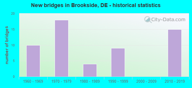
- New bridges - historical statistics
- 101960-1969
- 181970-1979
- 41980-1989
- 91990-1999
- 152010-2019
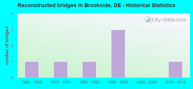
- Reconstructed bridges - Historical Statistics
- 11960-1969
- 11970-1979
- 11980-1989
- 31990-1999
- 02000-2009
- 12010-2019
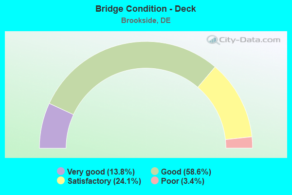
- Bridge Condition - Deck
- 13.8%Very good
- 58.6%Good
- 24.1%Satisfactory
- 3.4%Poor
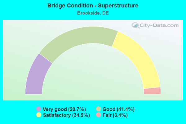
- Bridge Condition - Superstructure
- 20.7%Very good
- 41.4%Good
- 34.5%Satisfactory
- 3.4%Fair
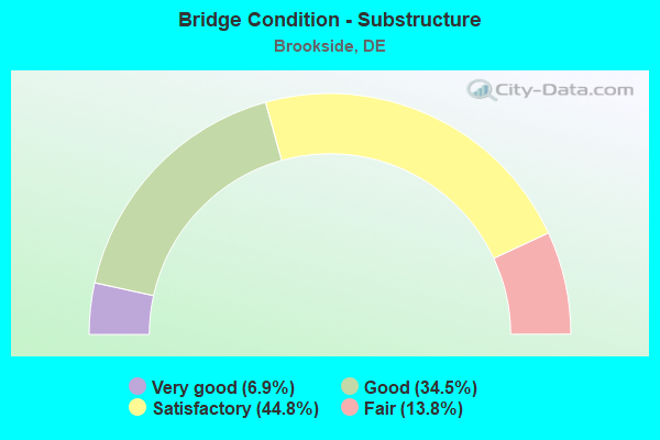
- Bridge Condition - Substructure
- 6.9%Very good
- 34.5%Good
- 44.8%Satisfactory
- 13.8%Fair
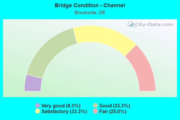
- Bridge Condition - Channel
- 8.3%Very good
- 33.3%Good
- 33.3%Satisfactory
- 25.0%Fair
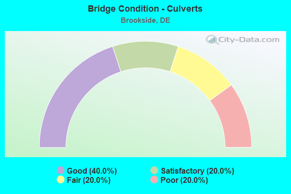
- Bridge Condition - Culverts
- 40.0%Good
- 20.0%Satisfactory
- 20.0%Fair
- 20.0%Poor
Find on map >> Show street view
Structure Number: 1230 352, Location: EAST OF NEWARK (Lat: 39.685806, Lng: -75.702114), Route carried "on" structure: County highway 352, Year Built: 1978, Status: Open, Structure Length: 6.43m (21.10ft), Average Daily Traffic: 15,079 (year 2019), Truck Traffic: 9%, Average Future Daily Traffic: 18,742 (year 2042), Design Load: HS 20, Features Intersected: AMTRAK, Facility Carried by Structure: RED MILL RD
Minimum Vertical Clearance: 30.48m (100.00ft), Kilometerpoint: 0.950, Lanes on structure: 2, Owner: State Highway Agency, Approaching Roadway Width: 13.8m (45.3ft), Skew: 1 degrees, Material/Design: Steel continuous, Design/Construction: Stringer/Multi-beam, Number Of Spans In Main Unit: 3, Length of Maximum Span: 26.5m (86.9ft), Curb or Sidewalk Widths: Left: 0.0m, Right: 1.8m (5.9ft), Curb-To-Curb Width: 14.3m (46.9ft), Out-to-Out Width: 17.2m (56.4ft)
Condition: Deck: Good, Superstructure: Good, Substructure: Satisfactory, Operating Rating: 33.7 metric tons, Method Used To Determine Operating Rating: Load and Resistance Factor Rating (LRFR) rating reported by rating factor(RF) method using HL-93 loadings, Inventory Rating: 24.6 metric tons, Method Used To Determine Inventory Rating: Load and Resistance Factor Rating (LRFR) rating reported by rating factor(RF) method using HL-93 loadings, Structural Evaluation: Equal to present minimum criteria, Deck Geometry: Superior to present desirable criteria, Underclear: Superior to present desirable criteria, Approach Roadway Alignment: Equal to present desirable criteria, Designated Inspection Frequency: Every 24 months, Inspection Date: June 2020, Deck Structure Type: Concrete Cast-file-Place, Wearing Surface/Protective System: Wearing Surface: Monolithic Concrete, Deck Protection: Epoxy Coated Reinforcing
Find on map >> Show street view
Structure Number: 1236 352, Location: EAST OF NEWARK (Lat: 39.690914, Lng: -75.706789), Route carried "on" structure: County highway 352, Year Built: 1970, Status: Open, Structure Length: 5.33m (17.49ft), Average Daily Traffic: 22,887 (year 2019), Truck Traffic: 9%, Average Future Daily Traffic: 28,446 (year 2042), Design Load: HS 20, Features Intersected: WHITE CLAY CREEK, Facility Carried by Structure: RED MILL RD
Minimum Vertical Clearance: 30.48m (100.00ft), Kilometerpoint: 1.642, Lanes on structure: 2, Owner: State Highway Agency, Approaching Roadway Width: 12.3m (40.4ft), Material/Design: Steel continuous, Design/Construction: Stringer/Multi-beam, Number Of Spans In Main Unit: 3, Length of Maximum Span: 19.8m (65.0ft), Curb or Sidewalk Widths: Left: 0.0m, Right: 1.2m (3.9ft), Curb-To-Curb Width: 12.3m (40.4ft), Out-to-Out Width: 14.9m (48.9ft)
Condition: Deck: Satisfactory, Superstructure: Satisfactory, Substructure: Satisfactory, Channel: Satisfactory, Operating Rating: 36.0 metric tons, Method Used To Determine Operating Rating: Load and Resistance Factor Rating (LRFR) rating reported by rating factor(RF) method using HL-93 loadings, Inventory Rating: 27.9 metric tons, Method Used To Determine Inventory Rating: Load and Resistance Factor Rating (LRFR) rating reported by rating factor(RF) method using HL-93 loadings, Structural Evaluation: Equal to present minimum criteria, Deck Geometry: Somewhat better than minimum adequacy, Waterway Adequacy: Equal to present minimum criteria, Approach Roadway Alignment: Equal to present desirable criteria, Designated Inspection Frequency: Every 24 months, Inspection Date: July 2020, Deck Structure Type: Concrete Cast-file-Place, Wearing Surface/Protective System: Wearing Surface: Monolithic Concrete
Find on map >> Show street view
Structure Number: 1242 352, Location: EAST OF NEWARK (Lat: 39.691525, Lng: -75.708142), Route carried "on" structure: County highway 352, Year Built: 1971, Status: Open, Structure Length: 1.10m (3.61ft), Average Daily Traffic: 18,195 (year 2020), Truck Traffic: 7%, Average Future Daily Traffic: 28,446 (year 2042), Design Load: HS 20, Features Intersected: STREAM MILL POND, Facility Carried by Structure: RED MILL RD
Minimum Vertical Clearance: 30.48m (100.00ft), Kilometerpoint: 1.770, Lanes on structure: 2, Owner: State Highway Agency, Approaching Roadway Width: 13.3m (43.6ft), Skew: 20 degrees, Material/Design: Aluminum, Iron, Design/Construction: Culvert, Number Of Spans In Main Unit: 2, Length of Maximum Span: 5.0m (16.4ft)
Condition: Channel: Good, Culverts: Poor, Operating Rating: 32.7 metric tons, Method Used To Determine Operating Rating: Field evaluation and documented engineering judgment, Inventory Rating: 32.7 metric tons, Method Used To Determine Inventory Rating: Field evaluation and documented engineering judgment, Structural Evaluation: Meets minimum limits, Waterway Adequacy: Equal to present desirable criteria, Approach Roadway Alignment: Equal to present desirable criteria, Designated Inspection Frequency: Every 12 months, Inspection Date: May 2021
Find on map >> Show street view
Structure Number: 1245 355, Location: EAST OF NEWARK (Lat: 39.690208, Lng: -75.687036), Route carried "on" structure: County highway 355, Year Built: 1972, Status: Open, Structure Length: 6.75m (22.15ft), Average Daily Traffic: 23,043 (year 2019), Truck Traffic: 8%, Average Future Daily Traffic: 28,912 (year 2043), Design Load: HS 20, Features Intersected: AMTRAK, Facility Carried by Structure: HARMONY RD
Minimum Vertical Clearance: 30.48m (100.00ft), Kilometerpoint: 1.850, Lanes on structure: 2, Owner: State Highway Agency, Approaching Roadway Width: 14.0m (45.9ft), Skew: 2 degrees, Material/Design: Steel continuous, Design/Construction: Stringer/Multi-beam, Number Of Spans In Main Unit: 3, Length of Maximum Span: 28.8m (94.5ft), Curb or Sidewalk Widths: Left: 0.0m, Right: 1.1m (3.6ft), Curb-To-Curb Width: 14.0m (45.9ft), Out-to-Out Width: 16.5m (54.1ft)
Condition: Deck: Satisfactory, Superstructure: Satisfactory, Substructure: Good, Operating Rating: 29.5 metric tons, Method Used To Determine Operating Rating: Load and Resistance Factor Rating (LRFR) rating reported by rating factor(RF) method using HL-93 loadings, Inventory Rating: 22.7 metric tons, Method Used To Determine Inventory Rating: Load and Resistance Factor Rating (LRFR) rating reported by rating factor(RF) method using HL-93 loadings, Structural Evaluation: Somewhat better than minimum adequacy, Deck Geometry: Superior to present desirable criteria, Underclear: Superior to present desirable criteria, Approach Roadway Alignment: Equal to present desirable criteria, Designated Inspection Frequency: Every 24 months, Inspection Date: March 2021, Bridge Improvement Cost: $848,000, Total Project Cost: $848,000, Deck Structure Type: Concrete Cast-file-Place, Wearing Surface/Protective System: Wearing Surface: Integral Concrete
Find on map >> Show street view
Structure Number: 1246 347, Location: W. OF CHRISTIANA (Lat: 39.666317, Lng: -75.690667), Route carried "on" structure: County highway 347, Year Built: 1983, Status: Open, Structure Length: 0.76m (2.49ft), Average Daily Traffic: 10,087 (year 2018), Truck Traffic: 6%, Average Future Daily Traffic: 13,507 (year 2040), Design Load: HS 20, Features Intersected: WATERWAY, Facility Carried by Structure: CHAPMAN RD.
Minimum Vertical Clearance: 30.48m (100.00ft), Kilometerpoint: 0.483, Lanes on structure: 2, Owner: State Highway Agency, Approaching Roadway Width: 13.9m (45.6ft), Material/Design: Steel, Design/Construction: Culvert, Number Of Spans In Main Unit: 2, Length of Maximum Span: 3.3m (10.8ft)
Condition: Channel: Satisfactory, Culverts: Fair, Operating Rating: 54.4 metric tons, Method Used To Determine Operating Rating: Field evaluation and documented engineering judgment, Inventory Rating: 32.7 metric tons, Method Used To Determine Inventory Rating: Field evaluation and documented engineering judgment, Structural Evaluation: Somewhat better than minimum adequacy, Waterway Adequacy: Equal to present minimum criteria, Approach Roadway Alignment: Equal to present desirable criteria, Length Of Structure Improvement: 0.76m (2.49ft), Designated Inspection Frequency: Every 24 months, Inspection Date: March 2020, Bridge Improvement Cost: $20,000, Roadway Improvement Cost: $3,000, Total Project Cost: $23,000
Find on map >> Show street view
Structure Number: 1247, Location: TODD ESTATES (Lat: 39.678708, Lng: -75.716800), Route carried "on" structure: City street , Year Built: 1976, Status: Open, Structure Length: 0.78m (2.56ft), Average Daily Traffic: 99 (year 2019), Truck Traffic: 10%, Average Future Daily Traffic: 123 (year 2042), Design Load: HS 20, Features Intersected: TRIB. TO WHITE CLAY CREE, Facility Carried by Structure: BRENNEN DR
Minimum Vertical Clearance: 30.48m (100.00ft), Kilometerpoint: 0.000, Lanes on structure: 2, Owner: State Highway Agency, Approaching Roadway Width: 10.9m (35.8ft), Material/Design: Steel, Design/Construction: Culvert, Number Of Spans In Main Unit: 1, Length of Maximum Span: 7.8m (25.6ft)
Condition: Channel: Satisfactory, Culverts: Satisfactory, Operating Rating: 54.4 metric tons, Method Used To Determine Operating Rating: Field evaluation and documented engineering judgment, Inventory Rating: 34.6 metric tons, Method Used To Determine Inventory Rating: Field evaluation and documented engineering judgment, Structural Evaluation: Equal to present minimum criteria, Waterway Adequacy: Better than present minimum criteria, Approach Roadway Alignment: Equal to present desirable criteria, Designated Inspection Frequency: Every 24 months, Inspection Date: May 2020
Find on map >> Show street view
Structure Number: 1251 355, Location: NORTH OF OGLETOWN (Lat: 39.697647, Lng: -75.696186), Route carried "on" structure: County highway 355, Year Built: 1973, Year Reconstructed: 2019, Status: Open, Structure Length: 5.61m (18.41ft), Average Daily Traffic: 18,674 (year 2018), Truck Traffic: 9%, Average Future Daily Traffic: 23,430 (year 2042), Design Load: HS 20, Features Intersected: WHITE CLAY CREEK, Facility Carried by Structure: HARMONY RD
Minimum Vertical Clearance: 30.48m (100.00ft), Kilometerpoint: 3.010, Lanes on structure: 2, Owner: State Highway Agency, Approaching Roadway Width: 14.0m (45.9ft), Material/Design: Steel continuous, Design/Construction: Stringer/Multi-beam, Number Of Spans In Main Unit: 3, Length of Maximum Span: 21.3m (69.9ft), Curb-To-Curb Width: 13.4m (44.0ft), Out-to-Out Width: 16.0m (52.5ft)
Condition: Deck: Very good, Superstructure: Good, Substructure: Good, Channel: Fair, Operating Rating: 58.3 metric tons, Method Used To Determine Operating Rating: Load and Resistance Factor Rating (LRFR) rating reported by rating factor(RF) method using HL-93 loadings, Inventory Rating: 45.0 metric tons, Method Used To Determine Inventory Rating: Load and Resistance Factor Rating (LRFR) rating reported by rating factor(RF) method using HL-93 loadings, Structural Evaluation: Better than present minimum criteria, Deck Geometry: Equal to present minimum criteria, Waterway Adequacy: Equal to present desirable criteria, Approach Roadway Alignment: Equal to present desirable criteria, Designated Inspection Frequency: Every 24 months, Inspection Date: March 2020, Deck Structure Type: Concrete Precast Panels, Wearing Surface/Protective System: Wearing Surface: Monolithic Concrete, Deck Protection: Epoxy Coated Reinforcing
Find on map >> Show street view
Structure Number: 1253 026, Location: S/E OF NEWARK (Lat: 39.644894, Lng: -75.720067), Route carried "on" structure: County highway 26, Year Built: 1982, Year Reconstructed: 1994, Status: Open, Structure Length: 1.26m (4.13ft), Average Daily Traffic: 19,112 (year 2019), Truck Traffic: 9%, Average Future Daily Traffic: 23,754 (year 2042), Design Load: HS 20, Features Intersected: TRIB OF CHRISTINA CRK, Facility Carried by Structure: OLD BALTIMORE PK
Minimum Vertical Clearance: 30.48m (100.00ft), Kilometerpoint: 6.260, Lanes on structure: 3, Owner: State Highway Agency, Approaching Roadway Width: 18.9m (62.0ft), Material/Design: Concrete, Design/Construction: Slab, Number Of Spans In Main Unit: 1, Length of Maximum Span: 10.1m (33.1ft), Curb or Sidewalk Widths: Left: 2.2m (7.2ft), Right: 3.0m (9.8ft), Curb-To-Curb Width: 18.9m (62.0ft), Out-to-Out Width: 25.0m (82.0ft)
Condition: Deck: Good, Superstructure: Satisfactory, Substructure: Satisfactory, Channel: Fair, Operating Rating: 77.8 metric tons, Method Used To Determine Operating Rating: Load and Resistance Factor Rating (LRFR) rating reported by rating factor(RF) method using HL-93 loadings, Inventory Rating: 59.9 metric tons, Method Used To Determine Inventory Rating: Load and Resistance Factor Rating (LRFR) rating reported by rating factor(RF) method using HL-93 loadings, Structural Evaluation: Equal to present minimum criteria, Deck Geometry: Superior to present desirable criteria, Waterway Adequacy: Equal to present minimum criteria, Approach Roadway Alignment: Equal to present desirable criteria, Designated Inspection Frequency: Every 24 months, Inspection Date: August 2020, Deck Structure Type: Concrete Cast-file-Place, Wearing Surface/Protective System: Wearing Surface: Bituminous, Deck Protection: Epoxy Coated Reinforcing
Find on map >> Show street view
Structure Number: 1254 35, Location: S/E OF NEWARK (Lat: 39.674511, Lng: -75.720178), Route carried "on" structure: County highway 350, Year Built: 2017, Status: Open, Structure Length: 0.84m (2.76ft), Average Daily Traffic: 2,706 (year 2020), Truck Traffic: 7%, Average Future Daily Traffic: 3,363 (year 2043), Design Load: HL 93, Features Intersected: COOL RUN, Facility Carried by Structure: OLD NEWARK RD
Minimum Vertical Clearance: 30.48m (100.00ft), Kilometerpoint: 1.030, Lanes on structure: 2, Owner: State Highway Agency, Approaching Roadway Width: 8.2m (26.9ft), Skew: 3 degrees, Material/Design: Concrete, Design/Construction: Culvert, Number Of Spans In Main Unit: 1, Length of Maximum Span: 8.4m (27.6ft), Curb or Sidewalk Widths: Left: 2.7m (8.9ft), Right: 0.2m (0.7ft), Curb-To-Curb Width: 8.5m (27.9ft), Out-to-Out Width: 13.7m (44.9ft)
Condition: Channel: Good, Culverts: Good, Operating Rating: 63.2 metric tons, Method Used To Determine Operating Rating: Load and Resistance Factor Rating (LRFR) rating reported by rating factor(RF) method using HL-93 loadings, Inventory Rating: 48.9 metric tons, Method Used To Determine Inventory Rating: Load and Resistance Factor Rating (LRFR) rating reported by rating factor(RF) method using HL-93 loadings, Structural Evaluation: Better than present minimum criteria, Deck Geometry: Meets minimum limits, Waterway Adequacy: Equal to present minimum criteria, Approach Roadway Alignment: Equal to present desirable criteria, Length Of Structure Improvement: 1.14m (3.74ft), Designated Inspection Frequency: Every 24 months, Inspection Date: October 2021, Bridge Improvement Cost: $308,000, Roadway Improvement Cost: $46,000, Total Project Cost: $354,000, Deck Structure Type: Concrete Precast Panels, Wearing Surface/Protective System: Wearing Surface: Bituminous, Deck Protection: Epoxy Coated Reinforcing
Find on map >> Show street view
Structure Number: 1255 018C, Location: NORTH OF OGLETOWN (Lat: 39.682875, Lng: -75.709850), Route carried "on" structure: County highway 18C, Year Built: 1999, Status: Open, Structure Length: 0.67m (2.20ft), Average Daily Traffic: 1,355 (year 2019), Truck Traffic: 8%, Average Future Daily Traffic: 1,700 (year 2043), Design Load: HS 25 or greater, Features Intersected: TRIBUTARY WHITE CLAY CRK, Facility Carried by Structure: OLD OGLETOWN RD.
Minimum Vertical Clearance: 30.48m (100.00ft), Kilometerpoint: 0.531, Lanes on structure: 2, Owner: State Highway Agency, Approaching Roadway Width: 13.9m (45.6ft), Material/Design: Concrete, Design/Construction: Culvert, Number Of Spans In Main Unit: 2, Length of Maximum Span: 3.0m (9.8ft), Curb-To-Curb Width: 9.8m (32.2ft), Out-to-Out Width: 10.4m (34.1ft)
Condition: Channel: Satisfactory, Culverts: Good, Operating Rating: 92.4 metric tons, Method Used To Determine Operating Rating: Load Factor (LF), Inventory Rating: 55.3 metric tons, Method Used To Determine Inventory Rating: Load Factor (LF), Structural Evaluation: Better than present minimum criteria, Deck Geometry: Somewhat better than minimum adequacy, Waterway Adequacy: Equal to present minimum criteria, Approach Roadway Alignment: Equal to present desirable criteria, Designated Inspection Frequency: Every 24 months, Inspection Date: March 2021, Deck Structure Type: Concrete Cast-file-Place, Wearing Surface/Protective System: Wearing Surface: Bituminous
Find on map >> Show street view
Structure Number: 1266A347, Location: NORTHWEST OF CHRISTIANA (Lat: 39.676750, Lng: -75.662722), Route carried "on" structure: County highway 347, Year Built: 2018, Status: Open, Structure Length: 3.44m (11.29ft), Average Daily Traffic: 21,396 (year 2019), Truck Traffic: 9%, Average Future Daily Traffic: 26,593 (year 2040), Design Load: HL 93, Features Intersected: TRIB TO CHRISTINA RIVER, Facility Carried by Structure: EAGLE RUN RD
Minimum Vertical Clearance: 30.48m (100.00ft), Kilometerpoint: 0.000, Lanes on structure: 2, Owner: State Highway Agency, Approaching Roadway Width: 10.9m (35.8ft), Skew: 2 degrees, Material/Design: Prestressed concrete, Design/Construction: Stringer/Multi-beam, Number Of Spans In Main Unit: 1, Length of Maximum Span: 33.5m (109.9ft), Curb or Sidewalk Widths: Left: 2.1m (6.9ft), Right: 0.0m, Curb-To-Curb Width: 10.4m (34.1ft), Out-to-Out Width: 12.8m (42.0ft)
Condition: Deck: Good, Superstructure: Good, Substructure: Good, Channel: Very good, Operating Rating: 57.3 metric tons, Method Used To Determine Operating Rating: Load and Resistance Factor Rating (LRFR) rating reported by rating factor(RF) method using HL-93 loadings, Inventory Rating: 38.6 metric tons, Method Used To Determine Inventory Rating: Load and Resistance Factor Rating (LRFR) rating reported by rating factor(RF) method using HL-93 loadings, Structural Evaluation: Better than present minimum criteria, Deck Geometry: Meets minimum limits, Waterway Adequacy: Equal to present desirable criteria, Approach Roadway Alignment: Equal to present desirable criteria, Designated Inspection Frequency: Every 24 months, Inspection Date: November 2020, Deck Structure Type: Concrete Cast-file-Place, Wearing Surface/Protective System: Wearing Surface: Monolithic Concrete, Deck Protection: Epoxy Coated Reinforcing
Find on map >> Show street view
Structure Number: 1268A6052, Location: CHRISTIANA MALL (Lat: 39.680694, Lng: -75.656722), Route carried "on" structure: Ramp Interstate 6052, Year Built: 2013, Status: Open, Structure Length: 11.24m (36.88ft), Average Daily Traffic: 28,576 (year 2019), Truck Traffic: 8%, Average Future Daily Traffic: 35,517 (year 2042), Design Load: HL 93, Features Intersected: SR7, Facility Carried by Structure: SR1NB-I95NB RAMP
Minimum Vertical Clearance: 30.45m (99.90ft), Kilometerpoint: 8.513, Lanes on structure: 2, Lanes under structure: 2, Base Highway Network: Yes, Owner: State Highway Agency, Approaching Roadway Width: 12.7m (41.7ft), Material/Design: Steel continuous, Design/Construction: Stringer/Multi-beam, Number Of Spans In Main Unit: 2, Length of Maximum Span: 55.0m (180.4ft), Curb-To-Curb Width: 13.2m (43.3ft), Out-to-Out Width: 13.7m (44.9ft)
Condition: Deck: Good, Superstructure: Very good, Substructure: Good, Operating Rating: 47.3 metric tons, Method Used To Determine Operating Rating: Load and Resistance Factor Rating (LRFR) rating reported by rating factor(RF) method using HL-93 loadings, Inventory Rating: 36.6 metric tons, Method Used To Determine Inventory Rating: Load and Resistance Factor Rating (LRFR) rating reported by rating factor(RF) method using HL-93 loadings, Structural Evaluation: Better than present minimum criteria, Deck Geometry: Superior to present desirable criteria, Underclear: Somewhat better than minimum adequacy, Approach Roadway Alignment: Equal to present desirable criteria, Designated Inspection Frequency: Every 24 months, Inspection Date: Febuary 2020, Deck Structure Type: Concrete Cast-file-Place, Wearing Surface/Protective System: Deck Protection: Epoxy Coated Reinforcing
Find on map >> Show street view
Structure Number: 1268B6052, Location: CHRISTIANA MALL (Lat: 39.684819, Lng: -75.653028), Route carried "on" structure: Ramp Interstate 6052, Year Built: 2013, Status: Open, Structure Length: 22.95m (75.30ft), Average Daily Traffic: 21,756 (year 2019), Truck Traffic: 11%, Average Future Daily Traffic: 27,041 (year 2042), Design Load: Greater than HL93, Features Intersected: I95 NB, Facility Carried by Structure: SR1NB-I95NB RAMP
Minimum Vertical Clearance: 30.45m (99.90ft), Kilometerpoint: 0.000, Lanes on structure: 1, Lanes under structure: 4, Base Highway Network: Yes, Owner: State Highway Agency, Approaching Roadway Width: 8.5m (27.9ft), Material/Design: Steel continuous, Design/Construction: Stringer/Multi-beam, Number Of Spans In Main Unit: 4, Length of Maximum Span: 59.2m (194.2ft), Curb-To-Curb Width: 9.4m (30.8ft), Out-to-Out Width: 10.3m (33.8ft)
Condition: Deck: Good, Superstructure: Very good, Substructure: Good, Operating Rating: 44.1 metric tons, Method Used To Determine Operating Rating: Load and Resistance Factor Rating (LRFR) rating reported by rating factor(RF) method using HL-93 loadings, Inventory Rating: 34.0 metric tons, Method Used To Determine Inventory Rating: Load and Resistance Factor Rating (LRFR) rating reported by rating factor(RF) method using HL-93 loadings, Structural Evaluation: Better than present minimum criteria, Deck Geometry: Superior to present desirable criteria, Underclear: Equal to present minimum criteria, Approach Roadway Alignment: Equal to present desirable criteria, Designated Inspection Frequency: Every 24 months, Inspection Date: Febuary 2020, Deck Structure Type: Concrete Cast-file-Place, Wearing Surface/Protective System: Wearing Surface: Monolithic Concrete, Deck Protection: Epoxy Coated Reinforcing
Find on map >> Show street view
Structure Number: 1286A6505, Location: OGLETOWN (Lat: 39.679189, Lng: -75.695175), Route carried "on" structure: Ramp State highway 273, Year Built: 1997, Status: Open, Structure Length: 5.39m (17.68ft), Average Daily Traffic: 16,637 (year 2019), Truck Traffic: 9%, Average Future Daily Traffic: 20,678 (year 2042), Design Load: HS 25 or greater, Features Intersected: SR 4
Minimum Vertical Clearance: 30.48m (100.00ft), Kilometerpoint: 0.100, Lanes on structure: 1, Lanes under structure: 5, Owner: State Highway Agency, Approaching Roadway Width: 8.5m (27.9ft), Skew: 1 degrees, Material/Design: Steel continuous, Design/Construction: Stringer/Multi-beam, Number Of Spans In Main Unit: 2, Length of Maximum Span: 27.1m (88.9ft), Curb-To-Curb Width: 8.5m (27.9ft), Out-to-Out Width: 9.3m (30.5ft)
Condition: Deck: Very good, Superstructure: Good, Substructure: Satisfactory, Operating Rating: 85.9 metric tons, Method Used To Determine Operating Rating: Load and Resistance Factor Rating (LRFR) rating reported by rating factor(RF) method using HL-93 loadings, Inventory Rating: 66.1 metric tons, Method Used To Determine Inventory Rating: Load and Resistance Factor Rating (LRFR) rating reported by rating factor(RF) method using HL-93 loadings, Structural Evaluation: Equal to present minimum criteria, Deck Geometry: Superior to present desirable criteria, Underclear: Equal to present minimum criteria, Approach Roadway Alignment: Equal to present desirable criteria, Designated Inspection Frequency: Every 24 months, Inspection Date: June 2020, Deck Structure Type: Concrete Cast-file-Place, Wearing Surface/Protective System: Wearing Surface: Monolithic Concrete, Deck Protection: Epoxy Coated Reinforcing
Find on map >> Show street view
Structure Number: 1286E018, Location: OGLETOWN (Lat: 39.678697, Lng: -75.696092), Route carried "on" structure: State highway 273, Year Built: 1988, Status: Open, Structure Length: 7.20m (23.62ft), Average Daily Traffic: 24,266 (year 2019), Truck Traffic: 6%, Average Future Daily Traffic: 30,447 (year 2043), Design Load: HS 25 or greater, Features Intersected: SR4
Minimum Vertical Clearance: 30.48m (100.00ft), Kilometerpoint: 4.039, Lanes on structure: 2, Lanes under structure: 5, Base Highway Network: Yes, Owner: State Highway Agency, Approaching Roadway Width: 12.2m (40.0ft), Skew: 4 degrees, Material/Design: Steel continuous, Design/Construction: Stringer/Multi-beam, Number Of Spans In Main Unit: 2, Length of Maximum Span: 35.0m (114.8ft), Curb-To-Curb Width: 13.7m (44.9ft), Out-to-Out Width: 14.5m (47.6ft)
Condition: Deck: Good, Superstructure: Good, Substructure: Satisfactory, Inventory Rating: 68.1 metric tons, Method Used To Determine Inventory Rating: Load Factor (LF), Structural Evaluation: Equal to present minimum criteria, Deck Geometry: Superior to present desirable criteria, Underclear: Equal to present minimum criteria, Approach Roadway Alignment: Equal to present desirable criteria, Length Of Structure Improvement: 7.92m (25.98ft), Designated Inspection Frequency: Every 24 months, Inspection Date: April 2021, Deck Structure Type: Concrete Cast-file-Place, Wearing Surface/Protective System: Wearing Surface: Monolithic Concrete, Deck Protection: Epoxy Coated Reinforcing
Find on map >> Show street view
Structure Number: 1286W018, Location: OGLETOWN (Lat: 39.678828, Lng: -75.695850), Route carried "on" structure: State highway 273, Year Built: 1997, Status: Open, Structure Length: 7.58m (24.87ft), Average Daily Traffic: 24,266 (year 2019), Truck Traffic: 6%, Average Future Daily Traffic: 30,447 (year 2043), Design Load: HS 25 or greater, Features Intersected: SR 4
Minimum Vertical Clearance: 30.48m (100.00ft), Kilometerpoint: 4.039, Lanes on structure: 2, Lanes under structure: 5, Base Highway Network: Yes, Owner: State Highway Agency, Approaching Roadway Width: 12.8m (42.0ft), Skew: 4 degrees, Material/Design: Steel continuous, Design/Construction: Stringer/Multi-beam, Number Of Spans In Main Unit: 2, Length of Maximum Span: 35.5m (116.5ft), Curb-To-Curb Width: 12.8m (42.0ft), Out-to-Out Width: 13.6m (44.6ft)
Condition: Deck: Good, Superstructure: Good, Substructure: Satisfactory, Inventory Rating: 77.3 metric tons, Method Used To Determine Inventory Rating: Load Factor (LF), Structural Evaluation: Equal to present minimum criteria, Deck Geometry: Equal to present desirable criteria, Underclear: Equal to present minimum criteria, Approach Roadway Alignment: Equal to present desirable criteria, Length Of Structure Improvement: 7.92m (25.98ft), Designated Inspection Frequency: Every 24 months, Inspection Date: April 2021, Deck Structure Type: Concrete Cast-file-Place, Wearing Surface/Protective System: Wearing Surface: Monolithic Concrete, Deck Protection: Epoxy Coated Reinforcing
Find on map >> Show street view
Structure Number: 1287E018, Location: OGLETOWN / EAST NEWARK (Lat: 39.685408, Lng: -75.703369), Route carried "on" structure: State highway 273, Year Built: 1997, Status: Open, Structure Length: 8.90m (29.20ft), Average Daily Traffic: 12,900 (year 2020), Truck Traffic: 6%, Average Future Daily Traffic: 16,033 (year 2043), Design Load: HS 25 or greater, Features Intersected: AMTRAK, Facility Carried by Structure: NEWARK-CHRISTIANA
Minimum Vertical Clearance: 30.48m (100.00ft), Kilometerpoint: 3.042, Lanes on structure: 2, Base Highway Network: Yes, Owner: State Highway Agency, Approaching Roadway Width: 12.2m (40.0ft), Skew: 4 degrees, Material/Design: Steel continuous, Design/Construction: Stringer/Multi-beam, Number Of Spans In Main Unit: 3, Length of Maximum Span: 40.8m (133.9ft), Curb-To-Curb Width: 13.4m (44.0ft), Out-to-Out Width: 14.4m (47.2ft)
Condition: Deck: Good, Superstructure: Good, Substructure: Satisfactory, Operating Rating: 42.8 metric tons, Method Used To Determine Operating Rating: Load and Resistance Factor Rating (LRFR) rating reported by rating factor(RF) method using HL-93 loadings, Inventory Rating: 33.0 metric tons, Method Used To Determine Inventory Rating: Load and Resistance Factor Rating (LRFR) rating reported by rating factor(RF) method using HL-93 loadings, Structural Evaluation: Equal to present minimum criteria, Deck Geometry: Superior to present desirable criteria, Underclear: Superior to present desirable criteria, Approach Roadway Alignment: Equal to present desirable criteria, Length Of Structure Improvement: 9.45m (31.00ft), Designated Inspection Frequency: Every 24 months, Inspection Date: April 2021, Deck Structure Type: Concrete Cast-file-Place, Wearing Surface/Protective System: Wearing Surface: Monolithic Concrete, Deck Protection: Epoxy Coated Reinforcing
Find on map >> Show street view
Structure Number: 1287W018, Location: OGLETOWN (Lat: 39.685486, Lng: -75.703103), Route carried "on" structure: State highway 273, Year Built: 1997, Status: Open, Structure Length: 8.90m (29.20ft), Average Daily Traffic: 25,799 (year 2020), Truck Traffic: 6%, Average Future Daily Traffic: 32,066 (year 2043), Design Load: HS 25 or greater, Features Intersected: AMTRAK
Minimum Vertical Clearance: 30.48m (100.00ft), Kilometerpoint: 10.235, Lanes on structure: 2, Base Highway Network: Yes, Owner: State Highway Agency, Approaching Roadway Width: 12.2m (40.0ft), Skew: 4 degrees, Material/Design: Steel continuous, Design/Construction: Stringer/Multi-beam, Number Of Spans In Main Unit: 3, Length of Maximum Span: 40.8m (133.9ft), Curb-To-Curb Width: 14.6m (47.9ft), Out-to-Out Width: 15.6m (51.2ft)
Condition: Deck: Good, Superstructure: Good, Substructure: Satisfactory, Operating Rating: 43.1 metric tons, Method Used To Determine Operating Rating: Load and Resistance Factor Rating (LRFR) rating reported by rating factor(RF) method using HL-93 loadings, Inventory Rating: 33.4 metric tons, Method Used To Determine Inventory Rating: Load and Resistance Factor Rating (LRFR) rating reported by rating factor(RF) method using HL-93 loadings, Structural Evaluation: Equal to present minimum criteria, Deck Geometry: Superior to present desirable criteria, Underclear: Superior to present desirable criteria, Approach Roadway Alignment: Equal to present desirable criteria, Length Of Structure Improvement: 9.45m (31.00ft), Designated Inspection Frequency: Every 24 months, Inspection Date: April 2021, Deck Structure Type: Concrete Cast-file-Place, Wearing Surface/Protective System: Wearing Surface: Monolithic Concrete, Deck Protection: Epoxy Coated Reinforcing
Find on map >> Show street view
Structure Number: 1355 356, Location: S. OF NEWARK (Lat: 39.637483, Lng: -75.728619), Route carried "on" structure: State highway 72, Year Built: 1969, Status: Open, Structure Length: 2.66m (8.73ft), Average Daily Traffic: 18,767 (year 2019), Truck Traffic: 9%, Average Future Daily Traffic: 23,326 (year 2042), Design Load: HS 20, Features Intersected: CHRISTINA CREEK, Facility Carried by Structure: SUNSET LAKE RD
Minimum Vertical Clearance: 30.48m (100.00ft), Kilometerpoint: 9.543, Lanes on structure: 2, Owner: State Highway Agency, Approaching Roadway Width: 12.8m (42.0ft), Skew: 3 degrees, Material/Design: Concrete continuous, Design/Construction: Slab, Number Of Spans In Main Unit: 3, Length of Maximum Span: 8.9m (29.2ft), Curb-To-Curb Width: 13.0m (42.7ft), Out-to-Out Width: 14.0m (45.9ft)
Condition: Deck: Good, Superstructure: Good, Substructure: Satisfactory, Channel: Fair, Operating Rating: 60.2 metric tons, Method Used To Determine Operating Rating: Load Factor (LF), Inventory Rating: 36.1 metric tons, Method Used To Determine Inventory Rating: Load Factor (LF), Structural Evaluation: Equal to present minimum criteria, Deck Geometry: Somewhat better than minimum adequacy, Waterway Adequacy: Equal to present desirable criteria, Approach Roadway Alignment: Equal to present desirable criteria, Designated Inspection Frequency: Every 24 months, Underwater Inspection Frequency: Every 48 months, Inspection Date: July 2020, Underwater Inspection Date: April 2018, Deck Structure Type: Concrete Cast-file-Place
Find on map >> Show street view
Structure Number: 1648E018, Location: OLGETOWN (Lat: 39.684386, Lng: -75.710211), Route carried "on" structure: State highway 273, Year Built: 1997, Status: Open, Structure Length: 2.67m (8.76ft), Average Daily Traffic: 12,857 (year 2020), Truck Traffic: 7%, Average Future Daily Traffic: 15,980 (year 2043), Design Load: HS 20+Mod, Features Intersected: COOL RUN
Minimum Vertical Clearance: 30.48m (100.00ft), Kilometerpoint: 2.446, Lanes on structure: 3, Base Highway Network: Yes, Owner: State Highway Agency, Approaching Roadway Width: 12.8m (42.0ft), Skew: 3 degrees, Material/Design: Prestressed concrete, Design/Construction: Stringer/Multi-beam, Number Of Spans In Main Unit: 1, Length of Maximum Span: 23.8m (78.1ft), Curb-To-Curb Width: 14.3m (46.9ft), Out-to-Out Width: 15.1m (49.5ft)
Condition: Deck: Good, Superstructure: Good, Substructure: Very good, Channel: Good, Operating Rating: 67.7 metric tons, Method Used To Determine Operating Rating: Load and Resistance Factor Rating (LRFR) rating reported by rating factor(RF) method using HL-93 loadings, Inventory Rating: 41.8 metric tons, Method Used To Determine Inventory Rating: Load and Resistance Factor Rating (LRFR) rating reported by rating factor(RF) method using HL-93 loadings, Structural Evaluation: Better than present minimum criteria, Deck Geometry: Somewhat better than minimum adequacy, Waterway Adequacy: Equal to present desirable criteria, Approach Roadway Alignment: Equal to present desirable criteria, Length Of Structure Improvement: 1.05m (3.44ft), Designated Inspection Frequency: Every 24 months, Inspection Date: May 2021, Deck Structure Type: Concrete Cast-file-Place, Wearing Surface/Protective System: Wearing Surface: Monolithic Concrete, Deck Protection: Epoxy Coated Reinforcing
Find on map >> Show street view
Structure Number: 1648W018, Location: OGLETOWN (Lat: 39.684553, Lng: -75.710389), Route carried "on" structure: State highway 273, Year Built: 1997, Status: Open, Structure Length: 2.67m (8.76ft), Average Daily Traffic: 12,857 (year 2020), Truck Traffic: 7%, Average Future Daily Traffic: 15,980 (year 2043), Design Load: HS 20+Mod, Features Intersected: COOL RUN
Minimum Vertical Clearance: 30.48m (100.00ft), Kilometerpoint: 10.895, Lanes on structure: 2, Base Highway Network: Yes, Owner: State Highway Agency, Approaching Roadway Width: 12.2m (40.0ft), Skew: 3 degrees, Material/Design: Prestressed concrete, Design/Construction: Stringer/Multi-beam, Number Of Spans In Main Unit: 1, Length of Maximum Span: 23.8m (78.1ft), Curb-To-Curb Width: 13.4m (44.0ft), Out-to-Out Width: 14.2m (46.6ft)
Condition: Deck: Good, Superstructure: Good, Substructure: Very good, Channel: Good, Operating Rating: 66.1 metric tons, Method Used To Determine Operating Rating: Load and Resistance Factor Rating (LRFR) rating reported by rating factor(RF) method using HL-93 loadings, Inventory Rating: 41.8 metric tons, Method Used To Determine Inventory Rating: Load and Resistance Factor Rating (LRFR) rating reported by rating factor(RF) method using HL-93 loadings, Structural Evaluation: Better than present minimum criteria, Deck Geometry: Superior to present desirable criteria, Waterway Adequacy: Better than present minimum criteria, Approach Roadway Alignment: Equal to present desirable criteria, Length Of Structure Improvement: 1.05m (3.44ft), Designated Inspection Frequency: Every 24 months, Inspection Date: May 2021, Deck Structure Type: Concrete Cast-file-Place, Wearing Surface/Protective System: Wearing Surface: Monolithic Concrete, Deck Protection: Epoxy Coated Reinforcing
Find on map >> Show street view
Structure Number: 1714 347, Location: E. OF NEWARK (Lat: 39.666325, Lng: -75.686625), Route carried "on" structure: County highway 347, Year Built: 1963, Year Reconstructed: 1999, Status: Open, Structure Length: 17.98m (58.99ft), Average Daily Traffic: 9,740 (year 2020), Truck Traffic: 7%, Average Future Daily Traffic: 15,228 (year 2042), Design Load: HS 20+Mod, Features Intersected: I 95, DELAWARE TURNPIKE, Facility Carried by Structure: CHAPMAN RD
Minimum Vertical Clearance: 30.48m (100.00ft), Kilometerpoint: 0.837, Lanes on structure: 2, Lanes under structure: 8, Owner: State Highway Agency, Approaching Roadway Width: 11.0m (36.1ft), Skew: 5 degrees, Material/Design: Steel, Design/Construction: Stringer/Multi-beam, Number Of Spans In Main Unit: 6, Length of Maximum Span: 41.1m (134.8ft), Curb or Sidewalk Widths: Left: 1.2m (3.9ft), Right: 1.2m (3.9ft), Curb-To-Curb Width: 8.5m (27.9ft), Out-to-Out Width: 11.6m (38.1ft)
Condition: Deck: Poor, Superstructure: Fair, Substructure: Fair, Operating Rating: 48.6 metric tons, Method Used To Determine Operating Rating: Load and Resistance Factor Rating (LRFR) rating reported by rating factor(RF) method using HL-93 loadings, Inventory Rating: 37.6 metric tons, Method Used To Determine Inventory Rating: Load and Resistance Factor Rating (LRFR) rating reported by rating factor(RF) method using HL-93 loadings, Structural Evaluation: Somewhat better than minimum adequacy, Deck Geometry: Meets minimum limits, Underclear: Meets minimum limits, Approach Roadway Alignment: Equal to present desirable criteria, Designated Inspection Frequency: Every 24 months, Other Special Inspection Frequency: Every 12 months, Inspection Date: July 2020, Other Special Inspection Date: July 2021, Bridge Improvement Cost: $800,000, Roadway Improvement Cost: $200,000, Total Project Cost: $1,000,000, Deck Structure Type: Concrete Cast-file-Place
Find on map >> Show street view
Structure Number: 1715 018, Location: EAST OF OGLETOWN (Lat: 39.672067, Lng: -75.675325), Route carried "on" structure: State highway 273, Year Built: 1971, Status: Open, Structure Length: 14.02m (46.00ft), Average Daily Traffic: 29,229 (year 2020), Truck Traffic: 6%, Average Future Daily Traffic: 36,329 (year 2043), Design Load: HS 20+Mod, Features Intersected: I 95, DELAWARE TURNPIKE
Minimum Vertical Clearance: 30.48m (100.00ft), Kilometerpoint: 6.019, Lanes on structure: 4, Lanes under structure: 10, Base Highway Network: Yes, Owner: State Highway Agency, Approaching Roadway Width: 24.8m (81.4ft), Skew: 30 degrees, Material/Design: Steel, Design/Construction: Stringer/Multi-beam, Number Of Spans In Main Unit: 6, Length of Maximum Span: 31.1m (102.0ft), Curb-To-Curb Width: 24.8m (81.4ft), Out-to-Out Width: 26.7m (87.6ft)
Condition: Deck: Satisfactory, Superstructure: Satisfactory, Substructure: Fair, Operating Rating: 54.1 metric tons, Method Used To Determine Operating Rating: Load and Resistance Factor Rating (LRFR) rating reported by rating factor(RF) method using HL-93 loadings, Inventory Rating: 41.8 metric tons, Method Used To Determine Inventory Rating: Load and Resistance Factor Rating (LRFR) rating reported by rating factor(RF) method using HL-93 loadings, Structural Evaluation: Somewhat better than minimum adequacy, Deck Geometry: Superior to present desirable criteria, Underclear: Somewhat better than minimum adequacy, Approach Roadway Alignment: Equal to present desirable criteria, Designated Inspection Frequency: Every 24 months, Inspection Date: May 2021, Deck Structure Type: Concrete Cast-file-Place, Wearing Surface/Protective System: Wearing Surface: Latex Concrete
Find on map >> Show street view
Structure Number: 1715A6048, Location: EAST OF OGLETOWN (Lat: 39.671875, Lng: -75.675608), Route carried "on" structure: Ramp Interstate 95, Year Built: 1972, Year Reconstructed: 2004, Status: Open, Structure Length: 14.42m (47.31ft), Average Daily Traffic: 9,095 (year 2020), Truck Traffic: 11%, Average Future Daily Traffic: 11,304 (year 2043), Design Load: HS 20+Mod, Features Intersected: I 95, Facility Carried by Structure: RAMP 6048
Minimum Vertical Clearance: 30.48m (100.00ft), Kilometerpoint: 0.418, Lanes on structure: 1, Lanes under structure: 10, Owner: State Highway Agency, Approaching Roadway Width: 8.5m (27.9ft), Material/Design: Steel, Design/Construction: Stringer/Multi-beam, Number Of Spans In Main Unit: 6, Length of Maximum Span: 31.4m (103.0ft), Curb-To-Curb Width: 8.5m (27.9ft), Out-to-Out Width: 9.6m (31.5ft)
Condition: Deck: Satisfactory, Superstructure: Satisfactory, Substructure: Fair, Operating Rating: 48.6 metric tons, Method Used To Determine Operating Rating: Load and Resistance Factor Rating (LRFR) rating reported by rating factor(RF) method using HL-93 loadings, Inventory Rating: 37.6 metric tons, Method Used To Determine Inventory Rating: Load and Resistance Factor Rating (LRFR) rating reported by rating factor(RF) method using HL-93 loadings, Structural Evaluation: Somewhat better than minimum adequacy, Deck Geometry: Superior to present desirable criteria, Underclear: Equal to present minimum criteria, Approach Roadway Alignment: Equal to present desirable criteria, Designated Inspection Frequency: Every 24 months, Inspection Date: May 2021, Deck Structure Type: Concrete Cast-file-Place, Wearing Surface/Protective System: Wearing Surface: Bituminous
Find on map >> Show street view
Structure Number: 1715B6047, Location: EAST OF OGLETOWN (Lat: 39.671481, Lng: -75.676222), Route carried "on" structure: Ramp Interstate 95, Year Built: 1963, Year Reconstructed: 1973, Status: Open, Structure Length: 14.40m (47.24ft), Average Daily Traffic: 14,630 (year 2020), Truck Traffic: 4%, Average Future Daily Traffic: 18,184 (year 2043), Design Load: HS 20+Mod, Features Intersected: I95 / JFK MEM HGWY
Minimum Vertical Clearance: 30.48m (100.00ft), Kilometerpoint: 0.241, Lanes on structure: 1, Lanes under structure: 11, Toll: On toll road, Owner: State Highway Agency, Approaching Roadway Width: 11.6m (38.1ft), Material/Design: Steel, Design/Construction: Stringer/Multi-beam, Number Of Spans In Main Unit: 6, Length of Maximum Span: 31.0m (101.7ft), Curb-To-Curb Width: 10.4m (34.1ft), Out-to-Out Width: 11.4m (37.4ft)
Condition: Deck: Satisfactory, Superstructure: Satisfactory, Substructure: Fair, Operating Rating: 42.1 metric tons, Method Used To Determine Operating Rating: Load and Resistance Factor Rating (LRFR) rating reported by rating factor(RF) method using HL-93 loadings, Inventory Rating: 32.7 metric tons, Method Used To Determine Inventory Rating: Load and Resistance Factor Rating (LRFR) rating reported by rating factor(RF) method using HL-93 loadings, Structural Evaluation: Somewhat better than minimum adequacy, Deck Geometry: Superior to present desirable criteria, Underclear: Equal to present minimum criteria, Approach Roadway Alignment: Equal to present desirable criteria, Designated Inspection Frequency: Every 24 months, Inspection Date: May 2021, Bridge Improvement Cost: $800,000, Roadway Improvement Cost: $200,000, Total Project Cost: $1,000,000, Deck Structure Type: Concrete Cast-file-Place, Wearing Surface/Protective System: Wearing Surface: Integral Concrete
Find on map >> Show street view
Structure Number: 1715C6047, Location: EAST OF NEWARK (Lat: 39.670381, Lng: -75.673814), Route carried "on" structure: Ramp Interstate 95, Year Built: 1970, Status: Open, Structure Length: 7.19m (23.59ft), Average Daily Traffic: 15,462 (year 2019), Truck Traffic: 15%, Average Future Daily Traffic: 19,218 (year 2042), Design Load: HS 20+Mod, Features Intersected: SR 273/CHRISTIANA RD., Facility Carried by Structure: RAMP 6047
Minimum Vertical Clearance: 30.48m (100.00ft), Kilometerpoint: 0.499, Lanes on structure: 1, Lanes under structure: 4, Owner: State Highway Agency, Approaching Roadway Width: 11.3m (37.1ft), Skew: 2 degrees, Material/Design: Steel, Design/Construction: Stringer/Multi-beam, Number Of Spans In Main Unit: 4, Length of Maximum Span: 23.5m (77.1ft), Curb-To-Curb Width: 11.3m (37.1ft), Out-to-Out Width: 12.3m (40.4ft)
Condition: Deck: Good, Superstructure: Satisfactory, Substructure: Satisfactory, Operating Rating: 58.3 metric tons, Method Used To Determine Operating Rating: Load and Resistance Factor Rating (LRFR) rating reported by rating factor(RF) method using HL-93 loadings, Inventory Rating: 45.0 metric tons, Method Used To Determine Inventory Rating: Load and Resistance Factor Rating (LRFR) rating reported by rating factor(RF) method using HL-93 loadings, Structural Evaluation: Equal to present minimum criteria, Deck Geometry: Superior to present desirable criteria, Underclear: Equal to present minimum criteria, Approach Roadway Alignment: Equal to present minimum criteria, Designated Inspection Frequency: Every 24 months, Inspection Date: July 2020, Bridge Improvement Cost: $800,000, Roadway Improvement Cost: $200,000, Total Project Cost: $1,000,000, Deck Structure Type: Concrete Cast-file-Place
Find on map >> Show street view
Structure Number: 1715D6048, Location: EAST OF OGLETOWN (Lat: 39.673794, Lng: -75.677025), Route carried "on" structure: Ramp Interstate 95, Year Built: 1972, Status: Open, Structure Length: 6.19m (20.31ft), Average Daily Traffic: 9,095 (year 2020), Truck Traffic: 11%, Average Future Daily Traffic: 11,304 (year 2043), Design Load: HS 20+Mod, Features Intersected: SR 273, Facility Carried by Structure: RAMP 6048
Minimum Vertical Clearance: 30.48m (100.00ft), Kilometerpoint: 0.209, Lanes on structure: 1, Lanes under structure: 4, Owner: State Highway Agency, Approaching Roadway Width: 9.1m (29.9ft), Skew: 1 degrees, Material/Design: Steel, Design/Construction: Stringer/Multi-beam, Number Of Spans In Main Unit: 3, Length of Maximum Span: 22.6m (74.1ft), Curb-To-Curb Width: 9.1m (29.9ft), Out-to-Out Width: 10.2m (33.5ft)
Condition: Deck: Good, Superstructure: Satisfactory, Substructure: Good, Operating Rating: 63.2 metric tons, Method Used To Determine Operating Rating: Load and Resistance Factor Rating (LRFR) rating reported by rating factor(RF) method using HL-93 loadings, Inventory Rating: 48.9 metric tons, Method Used To Determine Inventory Rating: Load and Resistance Factor Rating (LRFR) rating reported by rating factor(RF) method using HL-93 loadings, Structural Evaluation: Equal to present minimum criteria, Deck Geometry: Superior to present desirable criteria, Underclear: Somewhat better than minimum adequacy, Approach Roadway Alignment: Equal to present minimum criteria, Designated Inspection Frequency: Every 24 months, Inspection Date: May 2021, Deck Structure Type: Concrete Cast-file-Place, Wearing Surface/Protective System: Wearing Surface: Latex Concrete
Find on map >> Show street view
Structure Number: 1716 056, Location: NORTH OF CHRISTIANA (Lat: 39.684064, Lng: -75.656289), Route carried "on" structure: Interstate 95, Year Built: 1963, Year Reconstructed: 1970, Status: Open, Structure Length: 6.31m (20.70ft), Average Daily Traffic: 116,721 (year 2019), Truck Traffic: 5%, Average Future Daily Traffic: 145,075 (year 2042), Design Load: HS 20+Mod, Features Intersected: SR1/KOREAN WAR VET MEM
Minimum Vertical Clearance: 30.48m (100.00ft), Kilometerpoint: 40.330, Lanes on structure: 3, Lanes under structure: 6, Base Highway Network: Yes, Owner: State Highway Agency, Approaching Roadway Width: 15.8m (51.8ft), Skew: 3 degrees, Material/Design: Steel, Design/Construction: Stringer/Multi-beam, Number Of Spans In Main Unit: 4, Length of Maximum Span: 21.3m (69.9ft), Curb-To-Curb Width: 16.5m (54.1ft), Out-to-Out Width: 17.9m (58.7ft)
Condition: Deck: Satisfactory, Superstructure: Satisfactory, Substructure: Satisfactory, Operating Rating: 45.7 metric tons, Method Used To Determine Operating Rating: Load and Resistance Factor Rating (LRFR) rating reported by rating factor(RF) method using HL-93 loadings, Inventory Rating: 35.3 metric tons, Method Used To Determine Inventory Rating: Load and Resistance Factor Rating (LRFR) rating reported by rating factor(RF) method using HL-93 loadings, Structural Evaluation: Equal to present minimum criteria, Deck Geometry: Equal to present minimum criteria, Underclear: High priority of replacement, Approach Roadway Alignment: Equal to present desirable criteria, Length Of Structure Improvement: 6.31m (20.70ft), Designated Inspection Frequency: Every 24 months, Inspection Date: Febuary 2020, Bridge Improvement Cost: $800,000, Roadway Improvement Cost: $200,000, Total Project Cost: $1,000,000, Deck Structure Type: Concrete Cast-file-Place, Wearing Surface/Protective System: Wearing Surface: Other
Find on map >> Show street view
Structure Number: 1716A6059, Location: NORTH OF CHRISTIANA (Lat: 39.684422, Lng: -75.656192), Route carried "on" structure: Ramp Interstate 95, Year Built: 1977, Status: Open, Structure Length: 8.53m (27.99ft), Average Daily Traffic: 6,960 (year 2019), Truck Traffic: 12%, Average Future Daily Traffic: 8,650 (year 2042), Design Load: HS 20, Features Intersected: SR1/KOREAN WAR VET MEM, Facility Carried by Structure: RAMP 6059
Minimum Vertical Clearance: 30.48m (100.00ft), Kilometerpoint: 0.370, Lanes on structure: 2, Lanes under structure: 6, Owner: State Highway Agency, Approaching Roadway Width: 19.5m (64.0ft), Skew: 3 degrees, Material/Design: Steel, Design/Construction: Stringer/Multi-beam, Number Of Spans In Main Unit: 4, Length of Maximum Span: 30.2m (99.1ft), Curb-To-Curb Width: 18.8m (61.7ft), Out-to-Out Width: 21.4m (70.2ft)
Condition: Deck: Satisfactory, Superstructure: Good, Substructure: Satisfactory, Operating Rating: 42.4 metric tons, Method Used To Determine Operating Rating: Load and Resistance Factor Rating (LRFR) rating reported by rating factor(RF) method using HL-93 loadings, Inventory Rating: 32.7 metric tons, Method Used To Determine Inventory Rating: Load and Resistance Factor Rating (LRFR) rating reported by rating factor(RF) method using HL-93 loadings, Structural Evaluation: Equal to present minimum criteria, Deck Geometry: Superior to present desirable criteria, Underclear: High priority of replacement, Approach Roadway Alignment: Equal to present desirable criteria, Length Of Structure Improvement: 6.10m (20.01ft), Designated Inspection Frequency: Every 24 months, Inspection Date: Febuary 2020, Bridge Improvement Cost: $800,000, Roadway Improvement Cost: $200,000, Total Project Cost: $1,000,000, Deck Structure Type: Concrete Cast-file-Place, Wearing Surface/Protective System: Wearing Surface: Monolithic Concrete
Find on map >> Show street view
Structure Number: 1716B6058, Location: WEST OF CHRISTIANA MALL (Lat: 39.684958, Lng: -75.653528), Route carried "on" structure: Ramp Other road 6058, Year Built: 2014, Status: Open, Structure Length: 25.11m (82.38ft), Average Daily Traffic: 29,239 (year 2019), Truck Traffic: 8%, Average Future Daily Traffic: 36,341 (year 2042), Design Load: Greater than HL93, Features Intersected: I95 JFK MEM HWY, Facility Carried by Structure: I95SB - SR1SB RAMP
Minimum Vertical Clearance: 7.12m (23.36ft), Kilometerpoint: 0.000, Lanes on structure: 3, Lanes under structure: 8, Base Highway Network: Yes, Owner: State Highway Agency, Approaching Roadway Width: 15.4m (50.5ft), Skew: 3 degrees, Material/Design: Steel continuous, Design/Construction: Stringer/Multi-beam, Number Of Spans In Main Unit: 4, Length of Maximum Span: 76.1m (249.7ft), Curb-To-Curb Width: 16.5m (54.1ft), Out-to-Out Width: 17.3m (56.8ft)
Condition: Deck: Good, Superstructure: Very good, Substructure: Good, Operating Rating: 56.7 metric tons, Method Used To Determine Operating Rating: Load and Resistance Factor Rating (LRFR) rating reported by rating factor(RF) method using HL-93 loadings, Inventory Rating: 43.7 metric tons, Method Used To Determine Inventory Rating: Load and Resistance Factor Rating (LRFR) rating reported by rating factor(RF) method using HL-93 loadings, Structural Evaluation: Better than present minimum criteria, Deck Geometry: Superior to present desirable criteria, Underclear: Equal to present minimum criteria, Approach Roadway Alignment: Equal to present minimum criteria, Designated Inspection Frequency: Every 24 months, Inspection Date: Febuary 2020, Deck Structure Type: Concrete Cast-file-Place, Wearing Surface/Protective System: Wearing Surface: Monolithic Concrete, Deck Protection: Epoxy Coated Reinforcing
Find on map >> Show street view
Structure Number: 1716C6058, Location: WEST OF CHRISTIANA MALL (Lat: 39.680944, Lng: -75.656833), Route carried "on" structure: Ramp State highway 6052, Year Built: 2014, Status: Open, Structure Length: 14.94m (49.02ft), Average Daily Traffic: 29,714 (year 2019), Truck Traffic: 11%, Average Future Daily Traffic: 36,932 (year 2042), Design Load: Greater than HL93, Features Intersected: STANTON CHRISTIANA RD, Facility Carried by Structure: I95SB - SR1SB RAMP
Minimum Vertical Clearance: 30.45m (99.90ft), Kilometerpoint: 0.000, Lanes on structure: 2, Lanes under structure: 2, Base Highway Network: Yes, Owner: State Highway Agency, Approaching Roadway Width: 12.8m (42.0ft), Material/Design: Steel continuous, Design/Construction: Stringer/Multi-beam, Number Of Spans In Main Unit: 4, Length of Maximum Span: 42.9m (140.7ft), Curb-To-Curb Width: 12.8m (42.0ft), Out-to-Out Width: 13.7m (44.9ft)
Condition: Deck: Very good, Superstructure: Very good, Substructure: Good, Operating Rating: 48.0 metric tons, Method Used To Determine Operating Rating: Load and Resistance Factor Rating (LRFR) rating reported by rating factor(RF) method using HL-93 loadings, Inventory Rating: 36.9 metric tons, Method Used To Determine Inventory Rating: Load and Resistance Factor Rating (LRFR) rating reported by rating factor(RF) method using HL-93 loadings, Structural Evaluation: Better than present minimum criteria, Deck Geometry: Superior to present desirable criteria, Underclear: Somewhat better than minimum adequacy, Approach Roadway Alignment: Better than present minimum criteria, Designated Inspection Frequency: Every 24 months, Inspection Date: Febuary 2020, Deck Structure Type: Concrete Cast-file-Place, Wearing Surface/Protective System: Wearing Surface: Monolithic Concrete, Deck Protection: Epoxy Coated Reinforcing
Find on map >> Show street view
Structure Number: 1716D6058, Location: CHRISTINA MALL (Lat: 39.681139, Lng: -75.657139), Route carried "on" structure: State highway 6058, Year Built: 2014, Status: Open, Structure Length: 17.98m (58.99ft), Average Daily Traffic: 4,783 (year 2019), Truck Traffic: 8%, Average Future Daily Traffic: 5,944 (year 2042), Design Load: Greater than HL93, Features Intersected: STANTON CHRISTIANA RD, Facility Carried by Structure: I95/SR1SB-SR7 RAMP
Minimum Vertical Clearance: 30.45m (99.90ft), Kilometerpoint: 0.000, Lanes on structure: 1, Lanes under structure: 6, Base Highway Network: Yes, Toll: On toll road, Owner: State Highway Agency, Approaching Roadway Width: 10.1m (33.1ft), Material/Design: Steel continuous, Design/Construction: Stringer/Multi-beam, Number Of Spans In Main Unit: 4, Length of Maximum Span: 49.2m (161.4ft), Curb-To-Curb Width: 10.1m (33.1ft), Out-to-Out Width: 10.9m (35.8ft)
Condition: Deck: Good, Superstructure: Very good, Substructure: Good, Operating Rating: 50.9 metric tons, Method Used To Determine Operating Rating: Load and Resistance Factor Rating (LRFR) rating reported by rating factor(RF) method using HL-93 loadings, Inventory Rating: 39.2 metric tons, Method Used To Determine Inventory Rating: Load and Resistance Factor Rating (LRFR) rating reported by rating factor(RF) method using HL-93 loadings, Structural Evaluation: Better than present minimum criteria, Deck Geometry: Meets minimum limits, Underclear: Superior to present desirable criteria, Approach Roadway Alignment: Equal to present desirable criteria, Designated Inspection Frequency: Every 24 months, Inspection Date: Febuary 2020, Deck Structure Type: Concrete Cast-file-Place, Wearing Surface/Protective System: Wearing Surface: Monolithic Concrete, Deck Protection: Epoxy Coated Reinforcing
Find on map >> Show street view
Structure Number: 1717 056, Location: NORTH OF CHRISTIANA (Lat: 39.683806, Lng: -75.656361), Route carried "on" structure: Interstate 95, Year Built: 1963, Year Reconstructed: 1997, Status: Open, Structure Length: 6.37m (20.90ft), Average Daily Traffic: 102,934 (year 2016), Truck Traffic: 5%, Average Future Daily Traffic: 131,620 (year 2042), Design Load: HL 93, Features Intersected: SR1/KOREAN WAR VET MEM
Minimum Vertical Clearance: 30.48m (100.00ft), Kilometerpoint: 12.875, Lanes on structure: 4, Lanes under structure: 6, Base Highway Network: Yes, Owner: State Highway Agency, Approaching Roadway Width: 18.3m (60.0ft), Skew: 3 degrees, Material/Design: Steel, Design/Construction: Stringer/Multi-beam, Number Of Spans In Main Unit: 4, Length of Maximum Span: 21.4m (70.2ft), Curb-To-Curb Width: 25.8m (84.6ft), Out-to-Out Width: 26.6m (87.3ft)
Condition: Deck: Very good, Superstructure: Satisfactory, Substructure: Satisfactory, Operating Rating: 56.7 metric tons, Method Used To Determine Operating Rating: Load and Resistance Factor Rating (LRFR) rating reported by rating factor(RF) method using HL-93 loadings, Inventory Rating: 43.7 metric tons, Method Used To Determine Inventory Rating: Load and Resistance Factor Rating (LRFR) rating reported by rating factor(RF) method using HL-93 loadings, Structural Evaluation: Equal to present minimum criteria, Deck Geometry: Superior to present desirable criteria, Underclear: High priority of replacement, Approach Roadway Alignment: Equal to present desirable criteria, Length Of Structure Improvement: 6.52m (21.39ft), Designated Inspection Frequency: Every 24 months, Inspection Date: Febuary 2020, Bridge Improvement Cost: $800,000, Roadway Improvement Cost: $200,000, Total Project Cost: $1,000,000, Deck Structure Type: Concrete Precast Panels, Wearing Surface/Protective System: Wearing Surface: Latex Concrete, Deck Protection: Epoxy Coated Reinforcing
Find on map >> Show street view
Structure Number: 1717A6053, Location: CHRISTIANA MALL (Lat: 39.681667, Lng: -75.656861), Route carried "on" structure: State highway 6053, Year Built: 2014, Status: Open, Structure Length: 8.06m (26.44ft), Average Daily Traffic: 5,556 (year 2019), Truck Traffic: 8%, Average Future Daily Traffic: 6,905 (year 2042), Design Load: Greater than HL93, Features Intersected: STANTON CHRISTIANA RD, Facility Carried by Structure: I95NB - SR7NB RAMP
Minimum Vertical Clearance: 30.45m (99.90ft), Kilometerpoint: 0.000, Lanes on structure: 1, Lanes under structure: 4, Owner: State Highway Agency, Approaching Roadway Width: 9.1m (29.9ft), Material/Design: Steel continuous, Design/Construction: Stringer/Multi-beam, Number Of Spans In Main Unit: 2, Length of Maximum Span: 45.4m (149.0ft), Curb-To-Curb Width: 8.2m (26.9ft), Out-to-Out Width: 9.1m (29.9ft)
Condition: Deck: Good, Superstructure: Very good, Substructure: Good, Operating Rating: 53.5 metric tons, Method Used To Determine Operating Rating: Load and Resistance Factor Rating (LRFR) rating reported by rating factor(RF) method using HL-93 loadings, Inventory Rating: 41.1 metric tons, Method Used To Determine Inventory Rating: Load and Resistance Factor Rating (LRFR) rating reported by rating factor(RF) method using HL-93 loadings, Structural Evaluation: Better than present minimum criteria, Deck Geometry: High priority of corrective action, Underclear: Somewhat better than minimum adequacy, Approach Roadway Alignment: Somewhat better than minimum adequacy, Designated Inspection Frequency: Every 24 months, Inspection Date: Febuary 2020, Deck Structure Type: Concrete Cast-file-Place, Wearing Surface/Protective System: Wearing Surface: Monolithic Concrete, Deck Protection: Epoxy Coated Reinforcing
Find on map >> Show street view
Structure Number: 1268A6052, Location: CHRISTIANA MALL (Lat: 39.680694, Lng: -75.656722), Route carried "under" structure: State highway 7, Year Built: 2013, Structure Length: 0. m, Average Daily Traffic: 42,959 (year 2019), Truck Traffic: 5%, Features Intersected: SR7, Facility Carried by Structure: SR1NB-I95NB RAMP
Minimum Vertical Clearance: 5.38m (17.65ft), Kilometerpoint: 8.481, Lanes on structure: 2, Lanes under structure: 2, Material/Design: Steel continuous, Design/Construction: Stringer/Multi-beam, Length of Maximum Span: 55.0m (180.4ft)
Find on map >> Show street view
Structure Number: 1268B6052, Location: CHRISTIANA MALL (Lat: 39.684819, Lng: -75.653028), Route carried "under" structure: Interstate 95, Year Built: 2013, Structure Length: 0. m, Average Daily Traffic: 116,721 (year 2019), Truck Traffic: 11%, Features Intersected: I95 NB
Minimum Vertical Clearance: 6.90m (22.64ft), Kilometerpoint: 13.132, Lanes on structure: 1, Lanes under structure: 4, Toll: On toll road, Material/Design: Steel continuous, Design/Construction: Stringer/Multi-beam, Length of Maximum Span: 59.2m (194.2ft)
Find on map >> Show street view
Structure Number: 1286A6505, Location: OGLETOWN (Lat: 39.679189, Lng: -75.695175), Route carried "under" structure: State highway 4, Year Built: 1997, Structure Length: 0. m, Average Daily Traffic: 29,823 (year 2019), Truck Traffic: 9%, Features Intersected: SR 4, Facility Carried by Structure: SR 273 RAMP 6505
Minimum Vertical Clearance: 5.29m (17.36ft), Kilometerpoint: 0.350, Lanes on structure: 1, Lanes under structure: 4, Material/Design: Steel continuous, Design/Construction: Stringer/Multi-beam, Length of Maximum Span: 27.1m (88.9ft)
Find on map >> Show street view
Structure Number: 1286E018, Location: OGLETOWN (Lat: 39.678697, Lng: -75.696092), Route carried "under" structure: State highway 4, Year Built: 1988, Structure Length: 0. m, Average Daily Traffic: 29,823 (year 2019), Truck Traffic: 9%, Features Intersected: SR4, Facility Carried by Structure: SR273
Minimum Vertical Clearance: 5.11m (16.77ft), Kilometerpoint: 0.274, Lanes on structure: 2, Lanes under structure: 5, Material/Design: Steel continuous, Design/Construction: Stringer/Multi-beam, Length of Maximum Span: 35.0m (114.8ft)
Find on map >> Show street view
Structure Number: 1286W018, Location: OGLETOWN (Lat: 39.678828, Lng: -75.695850), Route carried "under" structure: State highway 4, Year Built: 1997, Structure Length: 0. m, Average Daily Traffic: 29,823 (year 2019), Truck Traffic: 9%, Features Intersected: SR 4, Facility Carried by Structure: SR 273
Minimum Vertical Clearance: 5.22m (17.13ft), Kilometerpoint: 0.306, Lanes on structure: 2, Lanes under structure: 5, Material/Design: Steel continuous, Design/Construction: Stringer/Multi-beam, Length of Maximum Span: 35.5m (116.5ft)
Find on map >> Show street view
Structure Number: 1714 347, Location: E. OF NEWARK (Lat: 39.666325, Lng: -75.686625), Route carried "under" structure: Interstate 95, Year Built: 1963, Structure Length: 0. m, Average Daily Traffic: 101,169 (year 2020), Truck Traffic: 9%, Features Intersected: I 95, DELAWARE TURNPIKE, Facility Carried by Structure: CHAPMAN RD
Minimum Vertical Clearance: 5.26m (17.26ft), Kilometerpoint: 9.590, Lanes on structure: 2, Lanes under structure: 8, Toll: On toll road, Material/Design: Steel, Design/Construction: Stringer/Multi-beam, Length of Maximum Span: 41.1m (134.8ft)
Find on map >> Show street view
Structure Number: 1715 018, Location: EAST OF OGLETOWN (Lat: 39.672067, Lng: -75.675325), Route carried "under" structure: Ramp State highway 273, Year Built: 1971, Structure Length: 0. m, Average Daily Traffic: 1,603 (year 2020), Truck Traffic: 6%, Features Intersected: I 95, DELAWARE TURNPIKE
Minimum Vertical Clearance: 5.08m (16.67ft), Kilometerpoint: 10.650, Lanes on structure: 4, Lanes under structure: 1, Material/Design: Steel, Design/Construction: Stringer/Multi-beam, Length of Maximum Span: 31.1m (102.0ft)
Find on map >> Show street view
Structure Number: 1715 018, Location: EAST OF OGLETOWN (Lat: 39.672067, Lng: -75.675325), Route carried "under" structure: Interstate 95, Year Built: 1971, Structure Length: 0. m, Average Daily Traffic: 101,169 (year 2020), Truck Traffic: 11%, Features Intersected: I 95, DELAWARE TURNPIKE, Facility Carried by Structure: SR 273
Minimum Vertical Clearance: 4.88m (16.01ft), Kilometerpoint: 10.650, Lanes on structure: 4, Lanes under structure: 9, Material/Design: Steel, Design/Construction: Stringer/Multi-beam, Length of Maximum Span: 31.1m (102.0ft)
Find on map >> Show street view
Structure Number: 1715A6048, Location: EAST OF OGLETOWN (Lat: 39.671875, Lng: -75.675608), Route carried "under" structure: Ramp State highway 273, Year Built: 1972, Structure Length: 0. m, Average Daily Traffic: 1,603 (year 2020), Truck Traffic: 6%, Features Intersected: I 95, Facility Carried by Structure: RAMP 6048
Minimum Vertical Clearance: 7.50m (24.61ft), Kilometerpoint: 10.640, Lanes on structure: 1, Lanes under structure: 1, Material/Design: Steel, Design/Construction: Stringer/Multi-beam, Length of Maximum Span: 31.4m (103.0ft)
Find on map >> Show street view
Structure Number: 1715A6048, Location: EAST OF OGLETOWN (Lat: 39.671875, Lng: -75.675608), Route carried "under" structure: Interstate 95, Year Built: 1972, Structure Length: 0. m, Average Daily Traffic: 101,169 (year 2020), Truck Traffic: 11%, Features Intersected: I 95, Facility Carried by Structure: RAMP 6048
Minimum Vertical Clearance: 6.09m (19.98ft), Kilometerpoint: 10.640, Lanes on structure: 1, Lanes under structure: 9, Toll: On toll road, Material/Design: Steel, Design/Construction: Stringer/Multi-beam, Length of Maximum Span: 31.4m (103.0ft)