Bridge Statistics for Brooklyn Center, Minnesota (MN)
Condition, Traffic, Stress, Structural Evaluation, Project Costs
- National Bridge Inventory (NBI) Statistics
- 99Number of bridges
- 1,447ft / 441mTotal length
- $3,625,999,000Total costs
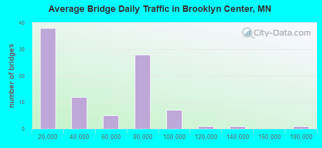
- 3,640,653Total average daily traffic
- 161,725Total average daily truck traffic
- National Bridge Inventory (NBI) Registered Bridges for Brooklyn Center
- No street view available for this location
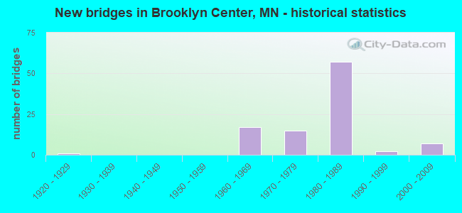
- New bridges - historical statistics
- 11920-1929
- 171960-1969
- 151970-1979
- 571980-1989
- 21990-1999
- 72000-2009
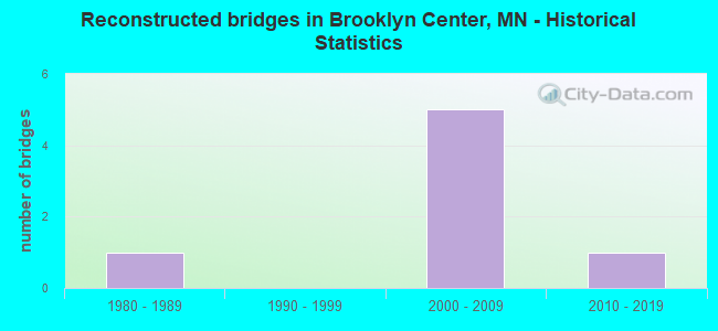
- Reconstructed bridges - Historical Statistics
- 11980-1989
- 01990-1999
- 52000-2009
- 12010-2019
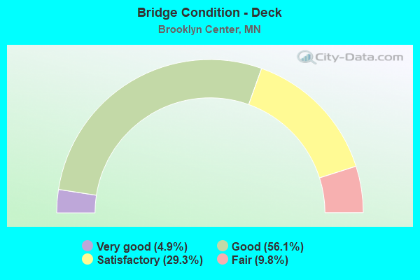
- Bridge Condition - Deck
- 4.9%Very good
- 56.1%Good
- 29.3%Satisfactory
- 9.8%Fair
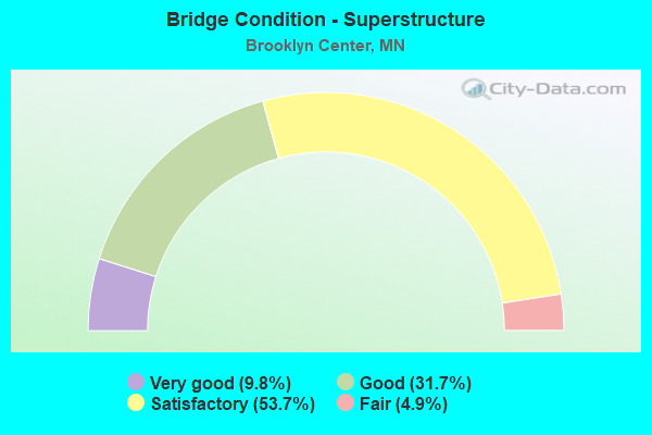
- Bridge Condition - Superstructure
- 9.8%Very good
- 31.7%Good
- 53.7%Satisfactory
- 4.9%Fair
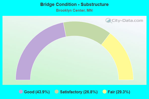
- Bridge Condition - Substructure
- 43.9%Good
- 26.8%Satisfactory
- 29.3%Fair
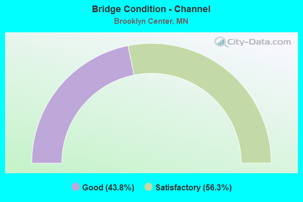
- Bridge Condition - Channel
- 43.8%Good
- 56.3%Satisfactory
Find on map >> Show street view
Structure Number: 27038, Location: 1.8 MI SW OF JCT TH 694 (Lat: 45.050964, Lng: -93.322197), Route carried "under" structure: State highway 100, Year Built: 1963, Structure Length: 0. m, Average Daily Traffic: 81,000 (year 2019), Truck Traffic: 4%, Features Intersected: TH 100, Facility Carried by Structure: CSAH 152
Minimum Vertical Clearance: 4.60m (15.09ft), Kilometerpoint: 0.000, Lanes on structure: 6, Lanes under structure: 6, Material/Design: Steel continuous, Design/Construction: Stringer/Multi-beam, Length of Maximum Span: 29.4m (96.5ft)
Find on map >> Show street view
Structure Number: 27038A, Location: South side BR 27038 (Lat: 45.050833, Lng: -93.322297), Route carried "under" structure: State highway 100, Year Built: 1976, Structure Length: 0. m, Average Daily Traffic: 81,000 (year 2019), Truck Traffic: 4%, Features Intersected: TH 100, Facility Carried by Structure: PEDESTRIAN
Minimum Vertical Clearance: 5.15m (16.90ft), Kilometerpoint: 0.000, Lanes on structure: 6, Lanes under structure: 6, Material/Design: Steel continuous, Design/Construction: Stringer/Multi-beam, Length of Maximum Span: 32.1m (105.3ft)
Find on map >> Show street view
Structure Number: 27038B, Location: North side BR 27038 (Lat: 45.051103, Lng: -93.322022), Route carried "under" structure: State highway 100, Year Built: 1976, Structure Length: 0. m, Average Daily Traffic: 81,000 (year 2019), Truck Traffic: 4%, Features Intersected: TH 100, Facility Carried by Structure: PEDESTRIAN
Minimum Vertical Clearance: 5.09m (16.70ft), Kilometerpoint: 0.000, Lanes on structure: 6, Lanes under structure: 6, Material/Design: Steel continuous, Design/Construction: Stringer/Multi-beam, Length of Maximum Span: 32.1m (105.3ft)
Find on map >> Show street view
Structure Number: 27041, Location: 0.9 MI SW OF JCT TH 694 (Lat: 45.058922, Lng: -93.308722), Route carried "under" structure: State highway 100, Year Built: 1967, Structure Length: 0. m, Average Daily Traffic: 74,000 (year 2019), Truck Traffic: 3%, Features Intersected: TH 100, Facility Carried by Structure: CSAH 57
Minimum Vertical Clearance: 5.40m (17.72ft), Kilometerpoint: 0.000, Lanes on structure: 4, Lanes under structure: 4, Material/Design: Prestressed concrete, Design/Construction: Stringer/Multi-beam, Length of Maximum Span: 22.1m (72.5ft)
Find on map >> Show street view
Structure Number: 27042, Location: 0.8 MI SW OF JCT TH 694 (Lat: 45.060119, Lng: -93.306800), Route carried "under" structure: State highway 100, Year Built: 1970, Structure Length: 0. m, Average Daily Traffic: 74,000 (year 2019), Truck Traffic: 3%, Features Intersected: TH 100; OFF RAMP, Facility Carried by Structure: MSAS 127
Minimum Vertical Clearance: 4.69m (15.39ft), Kilometerpoint: 0.000, Lanes on structure: 2, Lanes under structure: 4, Material/Design: Prestressed concrete, Design/Construction: Stringer/Multi-beam, Length of Maximum Span: 24.1m (79.1ft)
Find on map >> Show street view
Structure Number: 27042, Location: 0.8 MI SW OF JCT TH 694 (Lat: 45.060119, Lng: -93.306800), Route carried "under" structure: Ramp State highway 5220, Year Built: 1970, Structure Length: 0. m, Average Daily Traffic: 3,000 (year 1994), Features Intersected: TH 100; OFF RAMP, Facility Carried by Structure: MSAS 127
Minimum Vertical Clearance: 4.51m (14.80ft), Kilometerpoint: 0.000, Lanes on structure: 2, Lanes under structure: 1, Material/Design: Prestressed concrete, Design/Construction: Stringer/Multi-beam, Length of Maximum Span: 24.1m (79.1ft)
Find on map >> Show street view
Structure Number: 2728, Location: AT THE JCT TH 100; FRANCE (Lat: 45.042319, Lng: -93.330314), Route carried "under" structure: State highway 100, Year Built: 2003, Structure Length: 0. m, Average Daily Traffic: 81,000 (year 2019), Truck Traffic: 4%, Features Intersected: TH 100, Facility Carried by Structure: MSAS 105
Minimum Vertical Clearance: 4.94m (16.21ft), Kilometerpoint: 0.000, Lanes on structure: 4, Lanes under structure: 4, Material/Design: Prestressed concrete, Design/Construction: Stringer/Multi-beam, Length of Maximum Span: 30.8m (101.0ft)
Find on map >> Show street view
Structure Number: 27281, Location: 2.3 MI SW OF JCT TH 694 (Lat: 45.044228, Lng: -93.328292), Route carried "under" structure: State highway 100, Year Built: 2002, Structure Length: 0. m, Average Daily Traffic: 81,000 (year 2019), Truck Traffic: 4%, Features Intersected: TH 100, Facility Carried by Structure: RAILROAD
Minimum Vertical Clearance: 4.94m (16.21ft), Kilometerpoint: 0.000, Lanes on structure: 5, Lanes under structure: 6, Material/Design: Steel, Design/Construction: Stringer/Multi-beam, Length of Maximum Span: 22.0m (72.2ft)
Find on map >> Show street view
Structure Number: 27281, Location: 2.3 MI SW OF JCT TH 694 (Lat: 45.044228, Lng: -93.328292), Route carried "under" structure: Ramp State highway 3139, Year Built: 2002, Structure Length: 0. m, Average Daily Traffic: 1,000 (year 2003), Features Intersected: TH 100, Facility Carried by Structure: RAILROAD
Minimum Vertical Clearance: 5.00m (16.40ft), Kilometerpoint: 0.000, Lanes on structure: 1, Lanes under structure: 6, Material/Design: Steel, Design/Construction: Stringer/Multi-beam, Length of Maximum Span: 22.0m (72.2ft)
Find on map >> Show street view
Structure Number: 27281, Location: 2.3 MI SW OF JCT TH 694 (Lat: 45.044228, Lng: -93.328292), Route carried "under" structure: Ramp State highway 3168, Year Built: 2002, Structure Length: 0. m, Average Daily Traffic: 1,000 (year 2003), Features Intersected: TH 100, Facility Carried by Structure: RAILROAD
Minimum Vertical Clearance: 5.00m (16.40ft), Kilometerpoint: 0.000, Lanes on structure: 1, Lanes under structure: 6, Material/Design: Steel, Design/Construction: Stringer/Multi-beam, Length of Maximum Span: 22.0m (72.2ft)
Find on map >> Show street view
Structure Number: 27615, Location: 0.6 MI SW OF JCT TH 694 (Lat: 45.062175, Lng: -93.303453), Route carried "under" structure: State highway 100, Year Built: 1980, Structure Length: 0. m, Average Daily Traffic: 75,000 (year 2019), Truck Traffic: 3%, Features Intersected: TH 100; SB OFF RAMP, Facility Carried by Structure: PEDESTRIAN
Minimum Vertical Clearance: 5.91m (19.39ft), Kilometerpoint: 0.000, Lanes on structure: 4, Lanes under structure: 6, Material/Design: Steel continuous, Design/Construction: Stringer/Multi-beam, Length of Maximum Span: 37.9m (124.3ft)
Find on map >> Show street view
Structure Number: 27615, Location: 0.6 MI SW OF JCT TH 694 (Lat: 45.062175, Lng: -93.303453), Route carried "under" structure: Ramp State highway 5140, Year Built: 1980, Structure Length: 0. m, Average Daily Traffic: 2,500 (year 1994), Features Intersected: TH 100; SB OFF RAMP, Facility Carried by Structure: PEDESTRIAN
Minimum Vertical Clearance: 5.61m (18.41ft), Kilometerpoint: 0.000, Lanes on structure: 2, Lanes under structure: 6, Material/Design: Steel continuous, Design/Construction: Stringer/Multi-beam, Length of Maximum Span: 37.9m (124.3ft)
Find on map >> Show street view
Structure Number: 27649, Location: 1.2 MI SW OF JCT TH 694 (Lat: 45.056197, Lng: -93.313164), Route carried "under" structure: State highway 100, Year Built: 1983, Structure Length: 0. m, Average Daily Traffic: 74,000 (year 2019), Truck Traffic: 3%, Features Intersected: TH 100, Facility Carried by Structure: PEDESTRIAN
Minimum Vertical Clearance: 5.33m (17.49ft), Kilometerpoint: 0.000, Lanes on structure: 5, Lanes under structure: 5, Material/Design: Steel continuous, Design/Construction: Stringer/Multi-beam, Length of Maximum Span: 36.6m (120.1ft)
Find on map >> Show street view
Structure Number: 27734, Location: AT THE JCT TH 694; 94 (Lat: 45.069517, Lng: -93.289053), Route carried "under" structure: Interstate 94, Year Built: 1980, Structure Length: 0. m, Average Daily Traffic: 26,500 (year 2004), Truck Traffic: 11%, Features Intersected: I 94 WB
Minimum Vertical Clearance: 5.27m (17.29ft), Kilometerpoint: 0.000, Lanes on structure: 4, Lanes under structure: 2, Material/Design: Steel continuous, Design/Construction: Stringer/Multi-beam, Length of Maximum Span: 42.1m (138.1ft)
Find on map >> Show street view
Structure Number: 27805, Location: 0.3 MI S OF JCT TH 694 (Lat: 45.067019, Lng: -93.286156), Route carried "under" structure: State highway 252, Year Built: 1964, Structure Length: 0. m, Average Daily Traffic: 35,500 (year 2004), Truck Traffic: 3%, Features Intersected: TH 252 SB, Facility Carried by Structure: I 94
Minimum Vertical Clearance: 4.91m (16.11ft), Kilometerpoint: 0.000, Lanes on structure: 2, Lanes under structure: 2, Material/Design: Steel continuous, Design/Construction: Stringer/Multi-beam, Length of Maximum Span: 27.4m (89.9ft)
Find on map >> Show street view
Structure Number: 27806, Location: 0.8 MI S OF JCT TH 694 (Lat: 45.058364, Lng: -93.287308), Route carried "under" structure: Interstate 94, Year Built: 1979, Structure Length: 0. m, Average Daily Traffic: 110,000 (year 2019), Truck Traffic: 4%, Features Intersected: I 94, Facility Carried by Structure: MSAS 103
Minimum Vertical Clearance: 5.85m (19.19ft), Kilometerpoint: 0.000, Lanes on structure: 4, Lanes under structure: 8, Material/Design: Steel continuous, Design/Construction: Stringer/Multi-beam, Length of Maximum Span: 28.3m (92.8ft)
Find on map >> Show street view
Structure Number: 27864, Location: 0.5 MI W OF JCT TH 100 (Lat: 45.071522, Lng: -93.309272), Route carried "under" structure: Interstate 94, Year Built: 1980, Structure Length: 0. m, Average Daily Traffic: 64,000 (year 2019), Truck Traffic: 5%, Features Intersected: I 94; I 694, Facility Carried by Structure: PEDESTRIAN
Minimum Vertical Clearance: 5.82m (19.09ft), Kilometerpoint: 0.000, Lanes on structure: 2, Lanes under structure: 8, Material/Design: Steel continuous, Design/Construction: Stringer/Multi-beam, Length of Maximum Span: 40.8m (133.9ft)
Find on map >> Show street view
Structure Number: 27864, Location: 0.5 MI W OF JCT TH 100 (Lat: 45.071522, Lng: -93.309272), Route carried "under" structure: Interstate 94, Year Built: 1980, Structure Length: 0. m, Average Daily Traffic: 60,000 (year 2004), Truck Traffic: 7%, Features Intersected: I 94; I 694, Facility Carried by Structure: PEDESTRIAN
Minimum Vertical Clearance: 5.88m (19.29ft), Kilometerpoint: 0.000, Lanes on structure: 4, Lanes under structure: 8, Material/Design: Steel continuous, Design/Construction: Stringer/Multi-beam, Length of Maximum Span: 40.8m (133.9ft)
Find on map >> Show street view
Structure Number: 27864, Location: 0.5 MI W OF JCT TH 100 (Lat: 45.071522, Lng: -93.309272), Route carried "under" structure: Interstate 694, Year Built: 1980, Structure Length: 0. m, Average Daily Traffic: 66,500 (year 2019), Truck Traffic: 5%, Features Intersected: I 94; I 694, Facility Carried by Structure: PEDESTRIAN
Minimum Vertical Clearance: 5.40m (17.72ft), Kilometerpoint: 0.000, Lanes on structure: 2, Lanes under structure: 8, Material/Design: Steel continuous, Design/Construction: Stringer/Multi-beam, Length of Maximum Span: 40.8m (133.9ft)
Find on map >> Show street view
Structure Number: 2789, Location: AT THE JCT TH 252; 694 (Lat: 45.070772, Lng: -93.286878), Route carried "under" structure: Ramp Interstate 1604, Year Built: 1988, Structure Length: 0. m, Average Daily Traffic: 6,000 (year 1994), Features Intersected: TH 252 SB RAMP, Facility Carried by Structure: CON 5067
Minimum Vertical Clearance: 4.91m (16.11ft), Kilometerpoint: 0.000, Lanes on structure: 2, Lanes under structure: 1, Material/Design: Concrete continuous, Design/Construction: Slab, Length of Maximum Span: 18.6m (61.0ft)
Find on map >> Show street view
Structure Number: 27891, Location: AT THE JCT TH 252; 694 (Lat: 45.069481, Lng: -93.286025), Route carried "under" structure: State highway 252, Year Built: 1980, Structure Length: 0. m, Average Daily Traffic: 67,000 (year 2019), Truck Traffic: 2%, Features Intersected: TH 252; SB OFF RAMP, Facility Carried by Structure: I 694
Minimum Vertical Clearance: 5.06m (16.60ft), Kilometerpoint: 0.000, Lanes on structure: 8, Lanes under structure: 6, Material/Design: Steel continuous, Design/Construction: Stringer/Multi-beam, Length of Maximum Span: 25.3m (83.0ft)
Find on map >> Show street view
Structure Number: 27891, Location: AT THE JCT TH 252; 694 (Lat: 45.069481, Lng: -93.286025), Route carried "under" structure: Ramp Interstate 1604, Year Built: 1980, Structure Length: 0. m, Average Daily Traffic: 2,000 (year 1994), Features Intersected: TH 252; SB OFF RAMP, Facility Carried by Structure: I 694
Minimum Vertical Clearance: 4.88m (16.01ft), Kilometerpoint: 0.000, Lanes on structure: 8, Lanes under structure: 1, Material/Design: Steel continuous, Design/Construction: Stringer/Multi-beam, Length of Maximum Span: 25.3m (83.0ft)
Find on map >> Show street view
Structure Number: 2791, Location: 0.4 MI W OF JCT TH 100 (Lat: 45.070992, Lng: -93.307122), Route carried "under" structure: Interstate 94, Year Built: 1979, Structure Length: 0. m, Average Daily Traffic: 64,000 (year 2019), Truck Traffic: 5%, Features Intersected: I 94; I 694 EB, Facility Carried by Structure: MSAS 109
Minimum Vertical Clearance: 5.06m (16.60ft), Kilometerpoint: 0.000, Lanes on structure: 4, Lanes under structure: 2, Material/Design: Steel continuous, Design/Construction: Stringer/Multi-beam, Length of Maximum Span: 44.7m (146.7ft)
Find on map >> Show street view
Structure Number: 2791, Location: 0.4 MI W OF JCT TH 100 (Lat: 45.070992, Lng: -93.307122), Route carried "under" structure: Ramp Interstate 2497, Year Built: 1979, Structure Length: 0. m, Average Daily Traffic: 1 (year 2021), Features Intersected: I 94; I 694 EB, Facility Carried by Structure: MSAS 109
Minimum Vertical Clearance: 5.03m (16.50ft), Kilometerpoint: 0.000, Lanes under structure: 1, Material/Design: Steel continuous, Design/Construction: Stringer/Multi-beam, Length of Maximum Span: 44.7m (146.7ft)
Find on map >> Show street view
Structure Number: 2791, Location: 0.4 MI W OF JCT TH 100 (Lat: 45.070992, Lng: -93.307122), Route carried "under" structure: Interstate 94, Year Built: 1979, Structure Length: 0. m, Average Daily Traffic: 65,500 (year 2008), Truck Traffic: 7%, Features Intersected: I 94; I 694 EB, Facility Carried by Structure: MSAS 109
Minimum Vertical Clearance: 5.00m (16.40ft), Kilometerpoint: 0.000, Lanes on structure: 4, Lanes under structure: 4, Material/Design: Steel continuous, Design/Construction: Stringer/Multi-beam, Length of Maximum Span: 44.7m (146.7ft)
Find on map >> Show street view
Structure Number: 2791, Location: 0.4 MI W OF JCT TH 100 (Lat: 45.070992, Lng: -93.307122), Route carried "under" structure: Interstate 694, Year Built: 1979, Structure Length: 0. m, Average Daily Traffic: 66,500 (year 2019), Truck Traffic: 5%, Features Intersected: I 94; I 694 EB, Facility Carried by Structure: MSAS 109
Minimum Vertical Clearance: 5.15m (16.90ft), Kilometerpoint: 0.000, Lanes on structure: 4, Lanes under structure: 2, Material/Design: Steel continuous, Design/Construction: Stringer/Multi-beam, Length of Maximum Span: 44.7m (146.7ft)
Find on map >> Show street view
Structure Number: 27913, Location: 0.1 MI W OF JCT TH 100 (Lat: 45.069361, Lng: -93.300239), Route carried "under" structure: Interstate 94, Year Built: 1980, Structure Length: 0. m, Average Daily Traffic: 64,000 (year 2019), Truck Traffic: 5%, Features Intersected: I 94, I694 EB; RAMPS, Facility Carried by Structure: CON 5148
Minimum Vertical Clearance: 8.20m (26.90ft), Kilometerpoint: 0.000, Lanes on structure: 1, Lanes under structure: 2, Material/Design: Steel continuous, Design/Construction: Stringer/Multi-beam, Length of Maximum Span: 32.9m (107.9ft)
Find on map >> Show street view
Structure Number: 27913, Location: 0.1 MI W OF JCT TH 100 (Lat: 45.069361, Lng: -93.300239), Route carried "under" structure: Ramp State highway 3083, Year Built: 1980, Structure Length: 0. m, Average Daily Traffic: 5,200 (year 1994), Features Intersected: I 94, I694 EB; RAMPS, Facility Carried by Structure: CON 5148
Minimum Vertical Clearance: 7.16m (23.49ft), Kilometerpoint: 0.000, Lanes on structure: 1, Lanes under structure: 2, Material/Design: Steel continuous, Design/Construction: Stringer/Multi-beam, Length of Maximum Span: 32.9m (107.9ft)
Find on map >> Show street view
Structure Number: 27913, Location: 0.1 MI W OF JCT TH 100 (Lat: 45.069361, Lng: -93.300239), Route carried "under" structure: Ramp State highway 2853, Year Built: 1980, Structure Length: 0. m, Average Daily Traffic: 5,400 (year 1994), Features Intersected: I 94, I694 EB; RAMPS, Facility Carried by Structure: CON 5148
Minimum Vertical Clearance: 8.81m (28.90ft), Kilometerpoint: 0.000, Lanes on structure: 1, Lanes under structure: 2, Material/Design: Steel continuous, Design/Construction: Stringer/Multi-beam, Length of Maximum Span: 32.9m (107.9ft)
Find on map >> Show street view
Structure Number: 27913, Location: 0.1 MI W OF JCT TH 100 (Lat: 45.069361, Lng: -93.300239), Route carried "under" structure: Ramp State highway 188, Year Built: 1980, Structure Length: 0. m, Average Daily Traffic: 3,100 (year 1994), Features Intersected: I 94, I694 EB; RAMPS, Facility Carried by Structure: CON 5148
Minimum Vertical Clearance: 7.71m (25.30ft), Kilometerpoint: 0.000, Lanes on structure: 1, Lanes under structure: 2, Material/Design: Steel continuous, Design/Construction: Stringer/Multi-beam, Length of Maximum Span: 32.9m (107.9ft)
Find on map >> Show street view
Structure Number: 27913, Location: 0.1 MI W OF JCT TH 100 (Lat: 45.069361, Lng: -93.300239), Route carried "under" structure: Interstate 694, Year Built: 1980, Structure Length: 0. m, Average Daily Traffic: 66,500 (year 2019), Truck Traffic: 5%, Features Intersected: I 94, I694 EB; RAMPS, Facility Carried by Structure: CON 5148
Minimum Vertical Clearance: 7.89m (25.89ft), Kilometerpoint: 0.000, Lanes on structure: 1, Lanes under structure: 2, Material/Design: Steel continuous, Design/Construction: Stringer/Multi-beam, Length of Maximum Span: 32.9m (107.9ft)
Find on map >> Show street view
Structure Number: 27913, Location: 0.1 MI W OF JCT TH 100 (Lat: 45.069361, Lng: -93.300239), Route carried "under" structure: Interstate 94, Year Built: 1980, Structure Length: 0. m, Average Daily Traffic: 65,500 (year 2008), Truck Traffic: 7%, Features Intersected: I 94, I694 EB; RAMPS, Facility Carried by Structure: CON 5148
Minimum Vertical Clearance: 7.35m (24.11ft), Kilometerpoint: 0.000, Lanes on structure: 1, Lanes under structure: 4, Material/Design: Steel continuous, Design/Construction: Stringer/Multi-beam, Length of Maximum Span: 32.9m (107.9ft)
Find on map >> Show street view
Structure Number: 27914, Location: 0.1 MI W OF JCT TH 100 (Lat: 45.068878, Lng: -93.299592), Route carried "under" structure: State highway 100, Year Built: 1980, Structure Length: 0. m, Average Daily Traffic: 33,000 (year 2008), Truck Traffic: 2%, Features Intersected: I 94;694EB;TH100;RAMPS, Facility Carried by Structure: CON 2939
Minimum Vertical Clearance: 5.70m (18.70ft), Kilometerpoint: 0.000, Lanes on structure: 1, Lanes under structure: 2, Material/Design: Steel continuous, Design/Construction: Stringer/Multi-beam, Length of Maximum Span: 42.7m (140.1ft)
Find on map >> Show street view
Structure Number: 27914, Location: 0.1 MI W OF JCT TH 100 (Lat: 45.068878, Lng: -93.299592), Route carried "under" structure: Interstate 94, Year Built: 1980, Structure Length: 0. m, Average Daily Traffic: 64,000 (year 2019), Truck Traffic: 5%, Features Intersected: I 94;694EB;TH100;RAMPS, Facility Carried by Structure: CON 2939
Minimum Vertical Clearance: 9.11m (29.89ft), Kilometerpoint: 0.000, Lanes on structure: 1, Lanes under structure: 2, Material/Design: Steel continuous, Design/Construction: Stringer/Multi-beam, Length of Maximum Span: 42.7m (140.1ft)
Find on map >> Show street view
Structure Number: 27914, Location: 0.1 MI W OF JCT TH 100 (Lat: 45.068878, Lng: -93.299592), Route carried "under" structure: Interstate 94, Year Built: 1980, Structure Length: 0. m, Average Daily Traffic: 64,000 (year 2019), Truck Traffic: 5%, Features Intersected: I 94;694EB;TH100;RAMPS, Facility Carried by Structure: CON 2939
Minimum Vertical Clearance: 9.11m (29.89ft), Kilometerpoint: 0.000, Lanes on structure: 1, Lanes under structure: 4, Material/Design: Steel continuous, Design/Construction: Stringer/Multi-beam, Length of Maximum Span: 42.7m (140.1ft)
Find on map >> Show street view
Structure Number: 27914, Location: 0.1 MI W OF JCT TH 100 (Lat: 45.068878, Lng: -93.299592), Route carried "under" structure: State highway 100, Year Built: 1980, Structure Length: 0. m, Average Daily Traffic: 37,500 (year 2019), Truck Traffic: 3%, Features Intersected: I 94;694EB;TH100;RAMPS, Facility Carried by Structure: CON 2939
Minimum Vertical Clearance: 5.52m (18.11ft), Kilometerpoint: 0.000, Lanes on structure: 1, Lanes under structure: 2, Material/Design: Steel continuous, Design/Construction: Stringer/Multi-beam, Length of Maximum Span: 42.7m (140.1ft)
Find on map >> Show street view
Structure Number: 27914, Location: 0.1 MI W OF JCT TH 100 (Lat: 45.068878, Lng: -93.299592), Route carried "under" structure: Ramp State highway 3083, Year Built: 1980, Structure Length: 0. m, Average Daily Traffic: 5,200 (year 1994), Truck Traffic: 8%, Features Intersected: I 94;694EB;TH100;RAMPS, Facility Carried by Structure: CON 2939
Minimum Vertical Clearance: 11.25m (36.91ft), Kilometerpoint: 0.000, Lanes on structure: 1, Lanes under structure: 2, Material/Design: Steel continuous, Design/Construction: Stringer/Multi-beam, Length of Maximum Span: 42.7m (140.1ft)
Find on map >> Show street view
Structure Number: 27914, Location: 0.1 MI W OF JCT TH 100 (Lat: 45.068878, Lng: -93.299592), Route carried "under" structure: Interstate 694, Year Built: 1980, Structure Length: 0. m, Average Daily Traffic: 66,500 (year 2019), Truck Traffic: 5%, Features Intersected: I 94;694EB;TH100;RAMPS, Facility Carried by Structure: CON 2939
Minimum Vertical Clearance: 11.25m (36.91ft), Kilometerpoint: 0.000, Lanes on structure: 1, Lanes under structure: 2, Material/Design: Steel continuous, Design/Construction: Stringer/Multi-beam, Length of Maximum Span: 42.7m (140.1ft)
Find on map >> Show street view
Structure Number: 27914, Location: 0.1 MI W OF JCT TH 100 (Lat: 45.068878, Lng: -93.299592), Route carried "under" structure: Ramp State highway 2853, Year Built: 1980, Structure Length: 0. m, Average Daily Traffic: 5,400 (year 1994), Features Intersected: I 94;694EB;TH100;RAMPS, Facility Carried by Structure: CON 2939
Minimum Vertical Clearance: 9.11m (29.89ft), Kilometerpoint: 0.000, Lanes on structure: 1, Lanes under structure: 2, Material/Design: Steel continuous, Design/Construction: Stringer/Multi-beam, Length of Maximum Span: 42.7m (140.1ft)
Find on map >> Show street view
Structure Number: 27923, Location: 1.7 MI W OF JCT TH 100 (Lat: 45.076019, Lng: -93.332778), Route carried "under" structure: County highway 152, Year Built: 1965, Structure Length: 0. m, Average Daily Traffic: 42,600 (year 2005), Features Intersected: Brooklyn Blvd Co. 152, Facility Carried by Structure: I 94
Minimum Vertical Clearance: 4.88m (16.01ft), Kilometerpoint: 0.000, Lanes on structure: 3, Lanes under structure: 6, Material/Design: Steel continuous, Design/Construction: Stringer/Multi-beam, Length of Maximum Span: 21.2m (69.6ft)
Find on map >> Show street view
Structure Number: 27924, Location: 1.7 MI W OF JCT TH 100 (Lat: 45.075825, Lng: -93.332589), Route carried "under" structure: County highway 152, Year Built: 1964, Structure Length: 0. m, Average Daily Traffic: 42,600 (year 2005), Features Intersected: Brooklyn Blvd Co. 152, Facility Carried by Structure: I 94
Minimum Vertical Clearance: 4.91m (16.11ft), Kilometerpoint: 0.000, Lanes on structure: 3, Lanes under structure: 6, Material/Design: Steel continuous, Design/Construction: Stringer/Multi-beam, Length of Maximum Span: 21.2m (69.6ft)
Find on map >> Show street view
Structure Number: 27929, Location: 0.3 MI E OF JCT TH 100 (Lat: 45.069558, Lng: -93.294036), Route carried "under" structure: Interstate 94, Year Built: 1980, Structure Length: 0. m, Average Daily Traffic: 26,500 (year 2004), Truck Traffic: 11%, Features Intersected: I 94, I 694; RAMPS, Facility Carried by Structure: MSAS 107
Minimum Vertical Clearance: 5.03m (16.50ft), Kilometerpoint: 0.000, Lanes on structure: 2, Lanes under structure: 2, Material/Design: Steel continuous, Design/Construction: Stringer/Multi-beam, Length of Maximum Span: 51.3m (168.3ft)
Find on map >> Show street view
Structure Number: 27929, Location: 0.3 MI E OF JCT TH 100 (Lat: 45.069558, Lng: -93.294036), Route carried "under" structure: Interstate 94, Year Built: 1980, Structure Length: 0. m, Average Daily Traffic: 25,500 (year 2019), Truck Traffic: 8%, Features Intersected: I 94, I 694; RAMPS, Facility Carried by Structure: MSAS 107
Minimum Vertical Clearance: 5.27m (17.29ft), Kilometerpoint: 0.000, Lanes on structure: 2, Lanes under structure: 2, Material/Design: Steel continuous, Design/Construction: Stringer/Multi-beam, Length of Maximum Span: 51.3m (168.3ft)
Find on map >> Show street view
Structure Number: 27929, Location: 0.3 MI E OF JCT TH 100 (Lat: 45.069558, Lng: -93.294036), Route carried "under" structure: Interstate 694, Year Built: 1980, Structure Length: 0. m, Average Daily Traffic: 66,500 (year 2019), Truck Traffic: 5%, Features Intersected: I 94, I 694; RAMPS, Facility Carried by Structure: MSAS 107
Minimum Vertical Clearance: 5.06m (16.60ft), Kilometerpoint: 0.000, Lanes on structure: 2, Lanes under structure: 4, Material/Design: Steel continuous, Design/Construction: Stringer/Multi-beam, Length of Maximum Span: 51.3m (168.3ft)
Find on map >> Show street view
Structure Number: 27929, Location: 0.3 MI E OF JCT TH 100 (Lat: 45.069558, Lng: -93.294036), Route carried "under" structure: Ramp State highway 4681, Year Built: 1980, Structure Length: 0. m, Average Daily Traffic: 1 (year 2019), Features Intersected: I 94, I 694; RAMPS, Facility Carried by Structure: MSAS 107
Minimum Vertical Clearance: 4.88m (16.01ft), Kilometerpoint: 0.000, Lanes under structure: 1, Material/Design: Steel continuous, Design/Construction: Stringer/Multi-beam, Length of Maximum Span: 51.3m (168.3ft)
Find on map >> Show street view
Structure Number: 27929, Location: 0.3 MI E OF JCT TH 100 (Lat: 45.069558, Lng: -93.294036), Route carried "under" structure: Ramp Interstate 1766, Year Built: 1980, Structure Length: 0. m, Average Daily Traffic: 1 (year 2019), Features Intersected: I 94, I 694; RAMPS, Facility Carried by Structure: MSAS 107
Minimum Vertical Clearance: 4.88m (16.01ft), Kilometerpoint: 0.000, Lanes under structure: 1, Material/Design: Steel continuous, Design/Construction: Stringer/Multi-beam, Length of Maximum Span: 51.3m (168.3ft)
Find on map >> Show street view
Structure Number: 27929, Location: 0.3 MI E OF JCT TH 100 (Lat: 45.069558, Lng: -93.294036), Route carried "under" structure: State highway 100, Year Built: 1980, Structure Length: 0. m, Average Daily Traffic: 65,000 (year 2012), Features Intersected: I 94, I 694; RAMPS, Facility Carried by Structure: MSAS 107
Minimum Vertical Clearance: 4.88m (16.01ft), Kilometerpoint: 0.000, Lanes under structure: 1, Material/Design: Steel continuous, Design/Construction: Stringer/Multi-beam, Length of Maximum Span: 51.3m (168.3ft)
Find on map >> Show street view
Structure Number: 27929, Location: 0.3 MI E OF JCT TH 100 (Lat: 45.069558, Lng: -93.294036), Route carried "under" structure: Ramp Interstate 2853, Year Built: 1980, Structure Length: 0. m, Average Daily Traffic: 2,300 (year 1994), Features Intersected: I 94, I 694; RAMPS, Facility Carried by Structure: MSAS 107
Minimum Vertical Clearance: 4.97m (16.31ft), Kilometerpoint: 0.000, Lanes on structure: 2, Lanes under structure: 2, Material/Design: Steel continuous, Design/Construction: Stringer/Multi-beam, Length of Maximum Span: 51.3m (168.3ft)
Find on map >> Show street view
Structure Number: 27929, Location: 0.3 MI E OF JCT TH 100 (Lat: 45.069558, Lng: -93.294036), Route carried "under" structure: Interstate 694, Year Built: 1980, Structure Length: 0. m, Average Daily Traffic: 48,500 (year 2004), Truck Traffic: 3%, Features Intersected: I 94, I 694; RAMPS, Facility Carried by Structure: MSAS 107
Minimum Vertical Clearance: 5.12m (16.80ft), Kilometerpoint: 0.000, Lanes on structure: 2, Lanes under structure: 5, Material/Design: Steel continuous, Design/Construction: Stringer/Multi-beam, Length of Maximum Span: 51.3m (168.3ft)
Find on map >> Show street view
Structure Number: 2796, Location: 0.2 MI W OF JCT TH 100 (Lat: 45.069342, Lng: -93.302556), Route carried "under" structure: Interstate 94, Year Built: 1980, Structure Length: 0. m, Average Daily Traffic: 64,000 (year 2019), Truck Traffic: 5%, Features Intersected: I 94 EB, Facility Carried by Structure: CON 3083
Minimum Vertical Clearance: 5.82m (19.09ft), Kilometerpoint: 0.000, Lanes on structure: 1, Lanes under structure: 4, Material/Design: Steel continuous, Design/Construction: Stringer/Multi-beam, Length of Maximum Span: 59.4m (194.9ft)
Find on map >> Show street view
Structure Number: 27962, Location: AT THE JCT TH 100; 94 (Lat: 45.069236, Lng: -93.298717), Route carried "under" structure: Interstate 94, Year Built: 1980, Structure Length: 0. m, Average Daily Traffic: 64,000 (year 2019), Truck Traffic: 5%, Features Intersected: I 94, I 694 EB; RAMP, Facility Carried by Structure: MN 100
Minimum Vertical Clearance: 5.40m (17.72ft), Kilometerpoint: 0.000, Lanes on structure: 2, Lanes under structure: 4, Material/Design: Steel continuous, Design/Construction: Stringer/Multi-beam, Length of Maximum Span: 59.0m (193.6ft)
Find on map >> Show street view
Structure Number: 27962, Location: AT THE JCT TH 100; 94 (Lat: 45.069236, Lng: -93.298717), Route carried "under" structure: Interstate 94, Year Built: 1980, Structure Length: 0. m, Average Daily Traffic: 64,000 (year 2019), Truck Traffic: 5%, Features Intersected: I 94, I 694 EB; RAMP, Facility Carried by Structure: MN 100
Minimum Vertical Clearance: 7.16m (23.49ft), Kilometerpoint: 0.000, Lanes on structure: 2, Lanes under structure: 3, Material/Design: Steel continuous, Design/Construction: Stringer/Multi-beam, Length of Maximum Span: 59.0m (193.6ft)
Find on map >> Show street view
Structure Number: 27962, Location: AT THE JCT TH 100; 94 (Lat: 45.069236, Lng: -93.298717), Route carried "under" structure: Interstate 694, Year Built: 1980, Structure Length: 0. m, Average Daily Traffic: 66,500 (year 2019), Truck Traffic: 5%, Features Intersected: I 94, I 694 EB; RAMP, Facility Carried by Structure: MN 100
Minimum Vertical Clearance: 5.55m (18.21ft), Kilometerpoint: 0.000, Lanes on structure: 2, Lanes under structure: 2, Material/Design: Steel continuous, Design/Construction: Stringer/Multi-beam, Length of Maximum Span: 59.0m (193.6ft)
Find on map >> Show street view
Structure Number: 27962, Location: AT THE JCT TH 100; 94 (Lat: 45.069236, Lng: -93.298717), Route carried "under" structure: Ramp State highway 188, Year Built: 1980, Structure Length: 0. m, Average Daily Traffic: 5,400 (year 1994), Features Intersected: I 94, I 694 EB; RAMP, Facility Carried by Structure: MN 100
Minimum Vertical Clearance: 6.43m (21.10ft), Kilometerpoint: 0.000, Lanes on structure: 2, Lanes under structure: 1, Material/Design: Steel continuous, Design/Construction: Stringer/Multi-beam, Length of Maximum Span: 59.0m (193.6ft)
Find on map >> Show street view
Structure Number: 27964, Location: 1.0 MI W OF JCT TH 100 (Lat: 45.074153, Lng: -93.318733), Route carried "under" structure: Interstate 94, Year Built: 1989, Structure Length: 0. m, Average Daily Traffic: 128,000 (year 2019), Truck Traffic: 5%, Features Intersected: I 94, Facility Carried by Structure: MSAS 110
Minimum Vertical Clearance: 5.00m (16.40ft), Kilometerpoint: 0.000, Lanes on structure: 2, Lanes under structure: 8, Material/Design: Prestressed concrete, Design/Construction: Stringer/Multi-beam, Length of Maximum Span: 33.7m (110.6ft)
Find on map >> Show street view
Structure Number: 27982, Location: AT THE JCT TH 100; 94 (Lat: 45.068828, Lng: -93.297981), Route carried "under" structure: Interstate 94, Year Built: 1980, Structure Length: 0. m, Average Daily Traffic: 64,000 (year 2019), Truck Traffic: 5%, Features Intersected: I 94 EB; EB ON RAMP, Facility Carried by Structure: MN 100
Minimum Vertical Clearance: 5.52m (18.11ft), Kilometerpoint: 0.000, Lanes on structure: 2, Lanes under structure: 3, Material/Design: Steel continuous, Design/Construction: Stringer/Multi-beam, Length of Maximum Span: 49.1m (161.1ft)
Find on map >> Show street view
Structure Number: 27982, Location: AT THE JCT TH 100; 94 (Lat: 45.068828, Lng: -93.297981), Route carried "under" structure: Ramp State highway 1766, Year Built: 1980, Structure Length: 0. m, Average Daily Traffic: 5,400 (year 1994), Features Intersected: I 94 EB; EB ON RAMP, Facility Carried by Structure: MN 100
Minimum Vertical Clearance: 5.67m (18.60ft), Kilometerpoint: 0.000, Lanes on structure: 2, Lanes under structure: 1, Material/Design: Steel continuous, Design/Construction: Stringer/Multi-beam, Length of Maximum Span: 49.1m (161.1ft)