Bridge Statistics for Bossier City, Louisiana (LA)
Condition, Traffic, Stress, Structural Evaluation, Project Costs
- National Bridge Inventory (NBI) Statistics
- 166Number of bridges
- 2,923ft / 891mTotal length
- $50,667,000Total costs
- 2,836,776Total average daily traffic
- 283,703Total average daily truck traffic
- National Bridge Inventory (NBI) Registered Bridges for Bossier City
- No street view available for this location
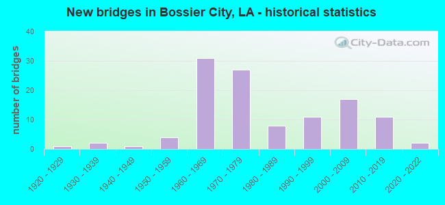
- New bridges - historical statistics
- 11920-1929
- 21930-1939
- 11940-1949
- 41950-1959
- 311960-1969
- 271970-1979
- 81980-1989
- 111990-1999
- 172000-2009
- 112010-2019
- 22020-2022
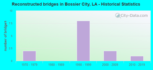
- Reconstructed bridges - Historical Statistics
- 21970-1979
- 01980-1989
- 81990-1999
- 22000-2009
- 12010-2019
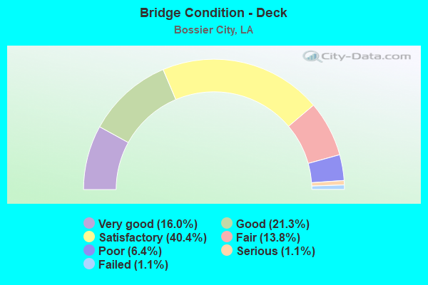
- Bridge Condition - Deck
- 16.0%Very good
- 21.3%Good
- 40.4%Satisfactory
- 13.8%Fair
- 6.4%Poor
- 1.1%Serious
- 1.1%Failed
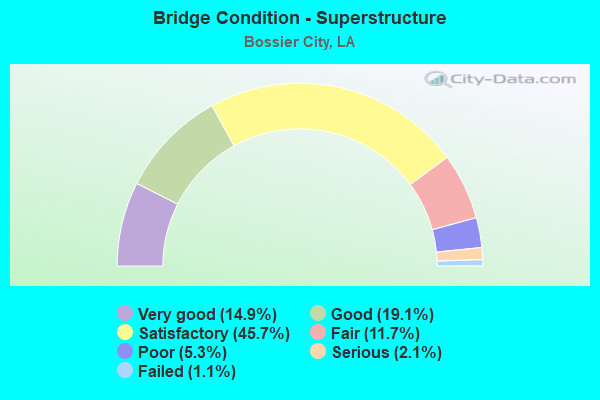
- Bridge Condition - Superstructure
- 14.9%Very good
- 19.1%Good
- 45.7%Satisfactory
- 11.7%Fair
- 5.3%Poor
- 2.1%Serious
- 1.1%Failed
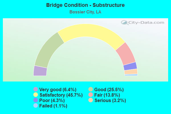
- Bridge Condition - Substructure
- 6.4%Very good
- 25.5%Good
- 45.7%Satisfactory
- 13.8%Fair
- 4.3%Poor
- 3.2%Serious
- 1.1%Failed
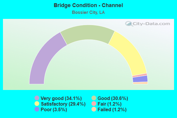
- Bridge Condition - Channel
- 34.1%Very good
- 30.6%Good
- 29.4%Satisfactory
- 1.2%Fair
- 3.5%Poor
- 1.2%Failed
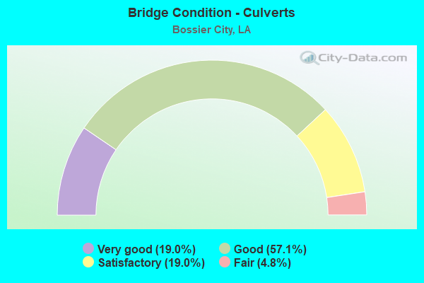
- Bridge Condition - Culverts
- 19.0%Very good
- 57.1%Good
- 19.0%Satisfactory
- 4.8%Fair
Find on map >> Show street view
Structure Number: 40800000000157, Location: 0.50 MI N OF I-220 (Lat: 32.565250, Lng: -93.681200), Route carried "on" structure: County highway , Year Built: 2019, Status: Open, Structure Length: 1.83m (6.00ft), Average Daily Traffic: 5,335 (year 2020), Average Future Daily Traffic: 5,869 (year 2037), Design Load: HS 20, Features Intersected: Willow Chute Bayou, Facility Carried by Structure: Swan Lake Rd
Minimum Vertical Clearance: 30+ m (98+ ft), Kilometerpoint: 3.743, Lanes on structure: 2, Owner: County Highway Agency, Approaching Roadway Width: 12.5m (41.0ft), Skew: 1 degrees, Material/Design: Concrete, Design/Construction: Culvert, Number Of Spans In Main Unit: 5, Length of Maximum Span: 3.0m (9.8ft), Curb-To-Curb Width: 12.5m (41.0ft), Out-to-Out Width: 29.9m (98.1ft)
Condition: Channel: Very good, Culverts: Good, Operating Rating: 49.9 metric tons, Method Used To Determine Operating Rating: Load and Resistance Factor Rating (LRFR) rating reported by rating factor(RF) method using HL-93 loadings, Inventory Rating: 38.2 metric tons, Method Used To Determine Inventory Rating: Load and Resistance Factor Rating (LRFR) rating reported by rating factor(RF) method using HL-93 loadings, Structural Evaluation: Better than present minimum criteria, Deck Geometry: Somewhat better than minimum adequacy, Waterway Adequacy: Equal to present desirable criteria, Approach Roadway Alignment: Equal to present desirable criteria, Designated Inspection Frequency: Every 24 months, Inspection Date: December 2020
Find on map >> Show street view
Structure Number: 40800000040399, Location: 0.01 MI W. OF LA 782-2 (Lat: 32.533011, Lng: -93.673700), Route carried "on" structure: US 80, Year Built: 2014, Status: Open, Structure Length: 1.37m (4.49ft), Average Daily Traffic: 19,200 (year 2016), Truck Traffic: 8%, Average Future Daily Traffic: 11,160 (year 2036), Design Load: HS 20, Features Intersected: MACKS BAYOU
Minimum Vertical Clearance: 30+ m (98+ ft), Kilometerpoint: 7.488, Lanes on structure: 7, Base Highway Network: Yes (Inventory Route: 1-03-1, Subroute: 10), Owner: State Highway Agency, Approaching Roadway Width: 7.0m (23.0ft), Skew: 30 degrees, Material/Design: Concrete, Design/Construction: Culvert, Number Of Spans In Main Unit: 4, Length of Maximum Span: 3.0m (9.8ft), Curb-To-Curb Width: 31.3m (102.7ft), Out-to-Out Width: 48.8m (160.1ft)
Condition: Channel: Very good, Culverts: Very good, Operating Rating: 42.1 metric tons, Method Used To Determine Operating Rating: Load and Resistance Factor Rating (LRFR) rating reported by rating factor(RF) method using HL-93 loadings, Inventory Rating: 32.4 metric tons, Method Used To Determine Inventory Rating: Load and Resistance Factor Rating (LRFR) rating reported by rating factor(RF) method using HL-93 loadings, Structural Evaluation: Equal to present desirable criteria, Deck Geometry: Better than present minimum criteria, Waterway Adequacy: Equal to present desirable criteria, Approach Roadway Alignment: Equal to present desirable criteria, Designated Inspection Frequency: Every 24 months, Inspection Date: November 2020, Deck Structure Type: Other
Find on map >> Show street view
Structure Number: 40800000040407, Location: 2.34 MI. E. OF US 71 (Lat: 32.444200, Lng: -93.608300), Route carried "on" structure: State highway 612, Year Built: 2017, Status: Open, Structure Length: 8.53m (27.99ft), Average Daily Traffic: 7,000 (year 2016), Truck Traffic: 22%, Average Future Daily Traffic: 8,800 (year 2035), Design Load: HL 93, Features Intersected: OLD CHANNEL OF RED CHUTE
Minimum Vertical Clearance: 30+ m (98+ ft), Kilometerpoint: 3.769, Lanes on structure: 2, Owner: State Highway Agency, Approaching Roadway Width: 7.3m (24.0ft), Material/Design: Concrete, Design/Construction: Slab, Number Of Spans In Main Unit: 14, Length of Maximum Span: 6.1m (20.0ft), Curb-To-Curb Width: 12.2m (40.0ft), Out-to-Out Width: 13.1m (43.0ft)
Condition: Deck: Very good, Superstructure: Very good, Substructure: Good, Channel: Very good, Operating Rating: 59.9 metric tons, Method Used To Determine Operating Rating: Load and Resistance Factor Rating (LRFR) rating reported by rating factor(RF) method using HL-93 loadings, Inventory Rating: 46.3 metric tons, Method Used To Determine Inventory Rating: Load and Resistance Factor Rating (LRFR) rating reported by rating factor(RF) method using HL-93 loadings, Structural Evaluation: Better than present minimum criteria, Deck Geometry: Somewhat better than minimum adequacy, Waterway Adequacy: Superior to present desirable criteria, Approach Roadway Alignment: Equal to present desirable criteria, Designated Inspection Frequency: Every 24 months, Underwater Inspection Frequency: Every 60 months, Inspection Date: November 2021, Underwater Inspection Date: June 2020, Deck Structure Type: Concrete Cast-file-Place
Find on map >> Show street view
Structure Number: 40800000040415, Location: 0.98 MI. W. OF LA 3 ON SI (Lat: 32.634961, Lng: -93.734161), Route carried "on" structure: County highway , Year Built: 2016, Status: Open, Structure Length: 3.05m (10.01ft), Average Daily Traffic: 100 (year 2020), Average Future Daily Traffic: 60 (year 2037), Design Load: HL 93, Features Intersected: Drain, Facility Carried by Structure: Silkwood
Minimum Vertical Clearance: 30+ m (98+ ft), Lanes on structure: 2, Owner: County Highway Agency, Approaching Roadway Width: 7.3m (24.0ft), Material/Design: Concrete, Design/Construction: Channel Beam, Number Of Spans In Main Unit: 4, Length of Maximum Span: 9.4m (30.8ft), Curb or Sidewalk Widths: Left: 0.0m, Right: 2.1m (6.9ft), Curb-To-Curb Width: 7.6m (24.9ft), Out-to-Out Width: 8.5m (27.9ft)
Condition: Deck: Very good, Superstructure: Very good, Substructure: Very good, Channel: Very good, Operating Rating: 43.7 metric tons, Method Used To Determine Operating Rating: Load and Resistance Factor Rating (LRFR) rating reported by rating factor(RF) method using HL-93 loadings, Inventory Rating: 33.7 metric tons, Method Used To Determine Inventory Rating: Load and Resistance Factor Rating (LRFR) rating reported by rating factor(RF) method using HL-93 loadings, Structural Evaluation: Equal to present desirable criteria, Deck Geometry: Equal to present minimum criteria, Waterway Adequacy: Equal to present desirable criteria, Approach Roadway Alignment: Equal to present desirable criteria, Designated Inspection Frequency: Every 24 months, Inspection Date: December 2020, Deck Structure Type: Concrete Cast-file-Place, Wearing Surface/Protective System: Wearing Surface: Monolithic Concrete
Find on map >> Show street view
Structure Number: 4080000004043, Location: 3.27 MI. E. OF US 71 (Lat: 32.448139, Lng: -93.594600), Route carried "on" structure: State highway 612, Year Built: 2016, Status: Open, Structure Length: 6.10m (20.01ft), Average Daily Traffic: 7,000 (year 2016), Truck Traffic: 22%, Average Future Daily Traffic: 4,320 (year 2036), Design Load: HS 20, Features Intersected: RED CHUTE BAYOU
Minimum Vertical Clearance: 30+ m (98+ ft), Kilometerpoint: 5.277, Lanes on structure: 2, Owner: State Highway Agency, Approaching Roadway Width: 7.6m (24.9ft), Skew: 30 degrees, Material/Design: Prestressed concrete, Design/Construction: Stringer/Multi-beam, Number Of Spans In Main Unit: 5, Length of Maximum Span: 12.2m (40.0ft), Curb-To-Curb Width: 12.0m (39.4ft), Out-to-Out Width: 12.9m (42.3ft)
Condition: Deck: Very good, Superstructure: Very good, Substructure: Very good, Channel: Good, Operating Rating: 67.4 metric tons, Method Used To Determine Operating Rating: Load and Resistance Factor Rating (LRFR) rating reported by rating factor(RF) method using HL-93 loadings, Inventory Rating: 46.0 metric tons, Method Used To Determine Inventory Rating: Load and Resistance Factor Rating (LRFR) rating reported by rating factor(RF) method using HL-93 loadings, Structural Evaluation: Equal to present desirable criteria, Deck Geometry: Somewhat better than minimum adequacy, Waterway Adequacy: Equal to present desirable criteria, Approach Roadway Alignment: Equal to present desirable criteria, Designated Inspection Frequency: Every 24 months, Underwater Inspection Frequency: Every 60 months, Inspection Date: November 2020, Underwater Inspection Date: June 2020, Deck Structure Type: Concrete Cast-file-Place, Wearing Surface/Protective System: Wearing Surface: Monolithic Concrete
Find on map >> Show street view
Structure Number: 40800000040447, Location: 1.1 mi e of la 3 (Lat: 32.607531, Lng: -93.722839), Route carried "on" structure: County highway , Year Built: 2018, Status: Posted for load, Structure Length: 0.94m (3.08ft), Average Daily Traffic: 870 (year 2020), Average Future Daily Traffic: 1,060 (year 2036), Design Load: HS 15, Features Intersected: Willow Chute Bayou, Facility Carried by Structure: Vanveville Rd
Minimum Vertical Clearance: 30+ m (98+ ft), Kilometerpoint: 1.770, Lanes on structure: 2, Owner: County Highway Agency, Approaching Roadway Width: 7.3m (24.0ft), Material/Design: Wood or Timber, Design/Construction: Stringer/Multi-beam, Number Of Spans In Main Unit: 2, Length of Maximum Span: 4.6m (15.1ft), Curb-To-Curb Width: 7.5m (24.6ft), Out-to-Out Width: 8.0m (26.2ft)
Condition: Deck: Very good, Superstructure: Very good, Substructure: Very good, Channel: Very good, Operating Rating: 34.0 metric tons, Method Used To Determine Operating Rating: Allowable Stress (AS), Inventory Rating: 24.9 metric tons, Method Used To Determine Inventory Rating: Allowable Stress (AS), Structural Evaluation: Equal to present minimum criteria, Deck Geometry: Meets minimum limits, Waterway Adequacy: Equal to present desirable criteria, Approach Roadway Alignment: Equal to present desirable criteria, Designated Inspection Frequency: Every 24 months, Inspection Date: December 2020, Deck Structure Type: Wood or Timber, Wearing Surface/Protective System: Wearing Surface: Bituminous
Find on map >> Show street view
Structure Number: 40800000040454, Location: 0.2 MI E OF LA 1 (Lat: 32.513719, Lng: -93.735981), Route carried "on" structure: Interstate 20, Year Built: 1965, Year Reconstructed: 2001, Status: Open, Structure Length: 13.23m (43.41ft), Average Daily Traffic: 43,600 (year 2017), Truck Traffic: 19%, Average Future Daily Traffic: 51,840 (year 2038), Design Load: HS 20, Features Intersected: RAMP J-2
Minimum Vertical Clearance: 30+ m (98+ ft), Kilometerpoint: 29.461, Lanes on structure: 3, Lanes under structure: 2, Base Highway Network: Yes (Inventory Route: 451-02-2, Subroute: 10), Owner: State Highway Agency, Approaching Roadway Width: 12.2m (40.0ft), Skew: 10 degrees, Material/Design: Steel continuous, Design/Construction: Girder and Floorbeam System, Number Of Spans In Main Unit: 4, Length of Maximum Span: 36.6m (120.1ft), Curb-To-Curb Width: 12.2m (40.0ft), Out-to-Out Width: 13.7m (44.9ft)
Condition: Deck: Good, Superstructure: Satisfactory, Substructure: Good, Operating Rating: 55.3 metric tons, Method Used To Determine Operating Rating: Load Factor (LF), Inventory Rating: 30.8 metric tons, Method Used To Determine Inventory Rating: Load Factor (LF), Structural Evaluation: Equal to present minimum criteria, Deck Geometry: High priority of corrective action, Underclear: Equal to present desirable criteria, Approach Roadway Alignment: Equal to present desirable criteria, Designated Inspection Frequency: Every 24 months, Inspection Date: July 2021, Deck Structure Type: Concrete Cast-file-Place
Find on map >> Show street view
Structure Number: 40800000040463, Location: 0.5 MI NE OF LA 3105 (Lat: 32.543269, Lng: -93.700900), Route carried "on" structure: City street , Year Built: 2018, Status: Open, Structure Length: 3.05m (10.01ft), Average Daily Traffic: 200 (year 2019), Average Future Daily Traffic: 150 (year 2038), Design Load: HL 93, Features Intersected: DRAIN, Facility Carried by Structure: PLANTATION DR
Minimum Vertical Clearance: 30+ m (98+ ft), Kilometerpoint: 0.810, Lanes on structure: 3, Owner: City or Municipal Highway Agency, Approaching Roadway Width: 11.9m (39.0ft), Skew: 2 degrees, Material/Design: Steel, Design/Construction: Culvert, Number Of Spans In Main Unit: 3, Length of Maximum Span: 9.1m (29.9ft), Curb-To-Curb Width: 11.9m (39.0ft), Out-to-Out Width: 21.8m (71.5ft)
Condition: Channel: Very good, Culverts: Very good, Operating Rating: 45.4 metric tons, Method Used To Determine Operating Rating: Load and Resistance Factor Rating (LRFR) rating reported by rating factor(RF) method using HL-93 loadings, Inventory Rating: 32.4 metric tons, Method Used To Determine Inventory Rating: Load and Resistance Factor Rating (LRFR) rating reported by rating factor(RF) method using HL-93 loadings, Structural Evaluation: Equal to present desirable criteria, Deck Geometry: High priority of corrective action, Waterway Adequacy: Equal to present desirable criteria, Approach Roadway Alignment: Equal to present desirable criteria, Designated Inspection Frequency: Every 24 months, Inspection Date: December 2020
Find on map >> Show street view
Structure Number: 40800000040464, Location: 1.05 MI NE OF LA 3105 (Lat: 32.550850, Lng: -93.700781), Route carried "on" structure: City street , Year Built: 2016, Status: Open, Structure Length: 1.55m (5.09ft), Average Daily Traffic: 200 (year 2019), Average Future Daily Traffic: 500 (year 2038), Design Load: HS 20, Features Intersected: DRAIN, Facility Carried by Structure: PLANTATION DRIVE
Minimum Vertical Clearance: 30+ m (98+ ft), Kilometerpoint: 1.688, Lanes on structure: 3, Owner: City or Municipal Highway Agency, Approaching Roadway Width: 11.9m (39.0ft), Skew: 3 degrees, Material/Design: Concrete, Design/Construction: Culvert, Number Of Spans In Main Unit: 4, Length of Maximum Span: 3.4m (11.2ft), Curb-To-Curb Width: 11.9m (39.0ft), Out-to-Out Width: 21.9m (71.9ft)
Condition: Channel: Very good, Culverts: Good, Operating Rating: 41.1 metric tons, Method Used To Determine Operating Rating: Load and Resistance Factor Rating (LRFR) rating reported by rating factor(RF) method using HL-93 loadings, Inventory Rating: 31.8 metric tons, Method Used To Determine Inventory Rating: Load and Resistance Factor Rating (LRFR) rating reported by rating factor(RF) method using HL-93 loadings, Structural Evaluation: Better than present minimum criteria, Deck Geometry: High priority of corrective action, Waterway Adequacy: Equal to present desirable criteria, Approach Roadway Alignment: Equal to present desirable criteria, Designated Inspection Frequency: Every 24 months, Inspection Date: December 2020
Find on map >> Show street view
Structure Number: 40800000040805, Location: 1.0 MI W OF LA 3105 (Lat: 32.563839, Lng: -93.695811), Route carried "on" structure: City street , Year Built: 2020, Status: Open, Structure Length: 1.37m (4.49ft), Average Daily Traffic: 50 (year 2020), Average Future Daily Traffic: 55 (year 2030), Design Load: HL 93, Features Intersected: BENOIT BAYOU, Facility Carried by Structure: INNOVATION DRIVE
Minimum Vertical Clearance: 30+ m (98+ ft), Kilometerpoint: 0.000, Lanes on structure: 3, Owner: City or Municipal Highway Agency, Approaching Roadway Width: 8.0m (26.2ft), Skew: 3 degrees, Material/Design: Concrete, Design/Construction: Culvert, Number Of Spans In Main Unit: 4, Length of Maximum Span: 3.0m (9.8ft), Curb or Sidewalk Widths: Left: 5.7m (18.7ft), Right: 5.8m (19.0ft), Curb-To-Curb Width: 12.6m (41.3ft), Out-to-Out Width: 24.0m (78.7ft)
Condition: Channel: Very good, Culverts: Very good, Operating Rating: 38.9 metric tons, Method Used To Determine Operating Rating: Load and Resistance Factor Rating (LRFR) rating reported by rating factor(RF) method using HL-93 loadings, Inventory Rating: 29.8 metric tons, Method Used To Determine Inventory Rating: Load and Resistance Factor Rating (LRFR) rating reported by rating factor(RF) method using HL-93 loadings, Structural Evaluation: Better than present minimum criteria, Deck Geometry: Meets minimum limits, Waterway Adequacy: Equal to present desirable criteria, Approach Roadway Alignment: Equal to present desirable criteria, Designated Inspection Frequency: Every 24 months, Inspection Date: December 2020
Find on map >> Show street view
Structure Number: 40800000040806, Location: 5.1 MI N OF I-220 (Lat: 32.617981, Lng: -93.690169), Route carried "on" structure: County highway , Year Built: 2020, Status: Open, Structure Length: 3.66m (12.01ft), Average Daily Traffic: 2,792 (year 2020), Average Future Daily Traffic: 3,000 (year 2040), Design Load: Greater than HL93, Features Intersected: FLAT RIVER, Facility Carried by Structure: SWAN LAKE RD.(N)
Minimum Vertical Clearance: 30+ m (98+ ft), Kilometerpoint: 11.121, Lanes on structure: 2, Owner: County Highway Agency, Approaching Roadway Width: 6.1m (20.0ft), Material/Design: Concrete, Design/Construction: Slab, Number Of Spans In Main Unit: 6, Length of Maximum Span: 6.1m (20.0ft), Curb-To-Curb Width: 12.0m (39.4ft), Out-to-Out Width: 13.0m (42.7ft)
Condition: Deck: Very good, Superstructure: Very good, Substructure: Very good, Channel: Very good, Operating Rating: 56.7 metric tons, Method Used To Determine Operating Rating: Load and Resistance Factor Rating (LRFR) rating reported by rating factor(RF) method using HL-93 loadings, Inventory Rating: 43.7 metric tons, Method Used To Determine Inventory Rating: Load and Resistance Factor Rating (LRFR) rating reported by rating factor(RF) method using HL-93 loadings, Structural Evaluation: Equal to present desirable criteria, Deck Geometry: Somewhat better than minimum adequacy, Waterway Adequacy: Equal to present desirable criteria, Approach Roadway Alignment: Superior to present desirable criteria, Designated Inspection Frequency: Every 24 months, Inspection Date: December 2020, Deck Structure Type: Concrete Precast Panels
Find on map >> Show street view
Structure Number: 40800000300415, Location: 0.7 MI NE OF US 71 (Lat: 32.404281, Lng: -93.599600), Route carried "on" structure: County highway , Year Built: 2014, Status: Open, Structure Length: 6.10m (20.01ft), Average Daily Traffic: 1,000 (year 2020), Average Future Daily Traffic: 510 (year 2036), Design Load: HS 20, Features Intersected: Flat River, Facility Carried by Structure: Caplis Sligo Rd
Minimum Vertical Clearance: 30+ m (98+ ft), Kilometerpoint: 1.268, Lanes on structure: 2, Owner: County Highway Agency, Approaching Roadway Width: 8.2m (26.9ft), Skew: 30 degrees, Material/Design: Prestressed concrete, Design/Construction: Stringer/Multi-beam, Number Of Spans In Main Unit: 5, Length of Maximum Span: 12.2m (40.0ft), Curb-To-Curb Width: 8.5m (27.9ft), Out-to-Out Width: 9.3m (30.5ft)
Condition: Deck: Very good, Superstructure: Very good, Substructure: Good, Channel: Very good, Operating Rating: 47.6 metric tons, Method Used To Determine Operating Rating: Load and Resistance Factor Rating (LRFR) rating reported by rating factor(RF) method using HL-93 loadings, Inventory Rating: 31.8 metric tons, Method Used To Determine Inventory Rating: Load and Resistance Factor Rating (LRFR) rating reported by rating factor(RF) method using HL-93 loadings, Structural Evaluation: Better than present minimum criteria, Deck Geometry: Somewhat better than minimum adequacy, Waterway Adequacy: Equal to present desirable criteria, Approach Roadway Alignment: Equal to present minimum criteria, Designated Inspection Frequency: Every 24 months, Inspection Date: December 2020, Deck Structure Type: Other, Wearing Surface/Protective System: Wearing Surface: Monolithic Concrete
Find on map >> Show street view
Structure Number: 40800000300434, Location: 1.9 MI N OF US80 (Lat: 32.569831, Lng: -93.634839), Route carried "on" structure: County highway , Year Built: 2013, Status: Open, Structure Length: 6.10m (20.01ft), Average Daily Traffic: 7,000 (year 2020), Truck Traffic: 10%, Average Future Daily Traffic: 4,200 (year 2036), Design Load: HS 20, Features Intersected: Red Chute Bayou, Facility Carried by Structure: Dogwood Trail
Minimum Vertical Clearance: 30+ m (98+ ft), Kilometerpoint: 0.000, Lanes on structure: 2, Owner: County Highway Agency, Approaching Roadway Width: 7.9m (25.9ft), Skew: 30 degrees, Material/Design: Prestressed concrete continuous, Design/Construction: Stringer/Multi-beam, Number Of Spans In Main Unit: 6, Length of Maximum Span: 10.1m (33.1ft), Curb or Sidewalk Widths: Left: 1.8m (5.9ft), Right: 0.0m, Curb-To-Curb Width: 9.6m (31.5ft), Out-to-Out Width: 12.5m (41.0ft)
Condition: Deck: Very good, Superstructure: Very good, Substructure: Good, Channel: Very good, Operating Rating: 70.0 metric tons, Method Used To Determine Operating Rating: Load and Resistance Factor Rating (LRFR) rating reported by rating factor(RF) method using HL-93 loadings, Inventory Rating: 54.1 metric tons, Method Used To Determine Inventory Rating: Load and Resistance Factor Rating (LRFR) rating reported by rating factor(RF) method using HL-93 loadings, Structural Evaluation: Better than present minimum criteria, Deck Geometry: Meets minimum limits, Waterway Adequacy: Equal to present desirable criteria, Approach Roadway Alignment: Equal to present desirable criteria, Designated Inspection Frequency: Every 24 months, Underwater Inspection Frequency: Every 60 months, Inspection Date: December 2020, Underwater Inspection Date: June 2020, Deck Structure Type: Concrete Cast-file-Place, Wearing Surface/Protective System: Wearing Surface: Monolithic Concrete
Find on map >> Show street view
Structure Number: 40800000300446, Location: 1.7 MILES EAST OF LA 3 (Lat: 32.552911, Lng: -93.696711), Route carried "on" structure: County highway , Year Built: 2009, Status: Open, Structure Length: 1.16m (3.81ft), Average Daily Traffic: 200 (year 2016), Average Future Daily Traffic: 120 (year 2036), Design Load: HS 20, Features Intersected: TRIB. TO MACKS BAYOU, Facility Carried by Structure: Viking Dr
Minimum Vertical Clearance: 30+ m (98+ ft), Kilometerpoint: 0.000, Lanes on structure: 2, Owner: City or Municipal Highway Agency, Approaching Roadway Width: 7.3m (24.0ft), Skew: 30 degrees, Material/Design: Steel, Design/Construction: Culvert, Number Of Spans In Main Unit: 5, Length of Maximum Span: 1.8m (5.9ft), Curb-To-Curb Width: 7.3m (24.0ft), Out-to-Out Width: 18.3m (60.0ft)
Condition: Channel: Good, Culverts: Good, Operating Rating: 97.2 metric tons, Method Used To Determine Operating Rating: Load and Resistance Factor Rating (LRFR) rating reported by rating factor(RF) method using HL-93 loadings, Inventory Rating: 74.5 metric tons, Method Used To Determine Inventory Rating: Load and Resistance Factor Rating (LRFR) rating reported by rating factor(RF) method using HL-93 loadings, Structural Evaluation: Better than present minimum criteria, Deck Geometry: Somewhat better than minimum adequacy, Waterway Adequacy: Equal to present minimum criteria, Approach Roadway Alignment: Equal to present desirable criteria, Designated Inspection Frequency: Every 24 months, Inspection Date: December 2020
Find on map >> Show street view
Structure Number: 40800010300001, Location: .01 MI EAST OF LA 1 (Lat: 32.515289, Lng: -93.746361), Route carried "on" structure: US 80, Year Built: 1934, Year Reconstructed: 1984, Status: Posted for load, Structure Length: 90.89m (298.20ft), Average Daily Traffic: 11,900 (year 2018), Truck Traffic: 8%, Average Future Daily Traffic: 7,500 (year 2036), Design Load: H 15, Features Intersected: RED RIVER @ TEXAS ST.
Minimum Vertical Clearance: 4.32m (14.17ft), Kilometerpoint: 0.002, Lanes on structure: 4, Lanes under structure: 8, Base Highway Network: Yes (Inventory Route: 1-03-1, Subroute: 10), Owner: State Highway Agency, Approaching Roadway Width: 15.9m (52.2ft), Skew: 20 degrees, Navigation Control: Yes ( Vertical Clearance: 94.5m (310.0ft), Horizontal Clearance: 106.7m (350.1ft)), Material/Design: Steel continuous, Design/Construction: Truss - Thru, Number Of Spans In Main Unit: 9, Number Of Approach Spans: 36, Length of Maximum Span: 158.5m (520.0ft), Curb or Sidewalk Widths: Left: 1.8m (5.9ft), Right: 1.8m (5.9ft), Curb-To-Curb Width: 12.2m (40.0ft), Out-to-Out Width: 16.5m (54.1ft)
Condition: Deck: Fair, Superstructure: Fair, Substructure: Satisfactory, Channel: Good, Operating Rating: 37.2 metric tons, Method Used To Determine Operating Rating: Load Factor (LF), Inventory Rating: 22.7 metric tons, Method Used To Determine Inventory Rating: Load Factor (LF), Structural Evaluation: Somewhat better than minimum adequacy, Deck Geometry: High priority of replacement, Underclear: High priority of replacement, Waterway Adequacy: Equal to present desirable criteria, Approach Roadway Alignment: Equal to present minimum criteria, Bridge Posting: Required (Relationship of Operating Rating to Maximum Legal Load: 0.1 - 9.9% below), Length Of Structure Improvement: 90.89m (298.20ft), Designated Inspection Frequency: Every 24 months, Critical Feature Inspection Frequency: Every 24 months, Underwater Inspection Frequency: Every 60 months, Inspection Date: July 2020, Critical Feature Inspection Date: July 2020, Underwater Inspection Date: July 2021, Bridge Improvement Cost: $7,772,000, Total Project Cost: $11,658,000 ( Estimate for 2016), Deck Structure Type: Concrete Cast-file-Place, Wearing Surface/Protective System: Wearing Surface: Epoxy Overlay, Membrane: Epoxy, Deck Protection: Other
Find on map >> Show street view
Structure Number: 40800010306051, Location: 1.2 MI E OF LA782-2 (Lat: 32.539931, Lng: -93.651900), Route carried "on" structure: US 80, Year Built: 1955, Status: Posted for load, Structure Length: 2.44m (8.01ft), Average Daily Traffic: 10,000 (year 2018), Truck Traffic: 8%, Average Future Daily Traffic: 7,128 (year 2036), Design Load: HS 20, Features Intersected: ALLIGATOR BAYOU
Minimum Vertical Clearance: 30+ m (98+ ft), Kilometerpoint: 9.671, Lanes on structure: 2, Base Highway Network: Yes (Inventory Route: 1-03-1, Subroute: 10), Owner: State Highway Agency, Approaching Roadway Width: 13.4m (44.0ft), Skew: 10 degrees, Material/Design: Concrete, Design/Construction: Slab, Number Of Spans In Main Unit: 4, Length of Maximum Span: 6.1m (20.0ft), Curb-To-Curb Width: 8.6m (28.2ft), Out-to-Out Width: 10.2m (33.5ft)
Condition: Deck: Poor, Superstructure: Poor, Substructure: Poor, Channel: Satisfactory, Operating Rating: 18.5 metric tons, Method Used To Determine Operating Rating: Load and Resistance Factor Rating (LRFR) rating reported by rating factor(RF) method using HL-93 loadings, Inventory Rating: 14.3 metric tons, Method Used To Determine Inventory Rating: Load and Resistance Factor Rating (LRFR) rating reported by rating factor(RF) method using HL-93 loadings, Structural Evaluation: High priority of replacement, Deck Geometry: High priority of corrective action, Waterway Adequacy: Equal to present minimum criteria, Approach Roadway Alignment: Equal to present desirable criteria, Bridge Posting: Required (Relationship of Operating Rating to Maximum Legal Load: 20.0 - 29.9% below), Length Of Structure Improvement: 3.23m (10.60ft), Designated Inspection Frequency: Every 12 months, Inspection Date: November 2021, Bridge Improvement Cost: $275,000, Total Project Cost: $412,000 ( Estimate for 2016), Deck Structure Type: Concrete Cast-file-Place, Wearing Surface/Protective System: Wearing Surface: Bituminous
Find on map >> Show street view
Structure Number: 40800010306052, Location: 1.2 MI E OF LA782-2 (Lat: 32.540231, Lng: -93.651600), Route carried "on" structure: US 80, Year Built: 1936, Status: Open, Structure Length: 4.94m (16.21ft), Average Daily Traffic: 9,750 (year 2016), Truck Traffic: 8%, Average Future Daily Traffic: 7,128 (year 2036), Design Load: H 15, Features Intersected: ALLIGATOR BAYOU
Minimum Vertical Clearance: 30+ m (98+ ft), Kilometerpoint: 20.025, Lanes on structure: 2, Base Highway Network: Yes (Inventory Route: 1-03-2, Subroute: 10), Owner: State Highway Agency, Approaching Roadway Width: 13.4m (44.0ft), Skew: 10 degrees, Material/Design: Concrete, Design/Construction: Slab, Number Of Spans In Main Unit: 8, Length of Maximum Span: 6.1m (20.0ft), Curb-To-Curb Width: 8.1m (26.6ft), Out-to-Out Width: 8.6m (28.2ft)
Condition: Deck: Poor, Superstructure: Poor, Substructure: Serious, Channel: Satisfactory, Operating Rating: 24.9 metric tons, Method Used To Determine Operating Rating: Load and Resistance Factor Rating (LRFR) rating reported by rating factor(RF) method using HL-93 loadings, Inventory Rating: 19.4 metric tons, Method Used To Determine Inventory Rating: Load and Resistance Factor Rating (LRFR) rating reported by rating factor(RF) method using HL-93 loadings, Structural Evaluation: High priority of corrective action, Deck Geometry: High priority of replacement, Waterway Adequacy: Equal to present minimum criteria, Approach Roadway Alignment: Equal to present desirable criteria, Length Of Structure Improvement: 5.85m (19.19ft), Designated Inspection Frequency: Every 12 months, Inspection Date: November 2021, Bridge Improvement Cost: $499,000, Total Project Cost: $748,000 ( Estimate for 2016), Deck Structure Type: Concrete Cast-file-Place, Wearing Surface/Protective System: Wearing Surface: Bituminous
Find on map >> Show street view
Structure Number: 40800010306651, Location: 1.8 MI EAST OF LA 782-2 (Lat: 32.543361, Lng: -93.641200), Route carried "on" structure: US 80, Year Built: 2003, Status: Open, Structure Length: 6.10m (20.01ft), Average Daily Traffic: 9,750 (year 2016), Truck Traffic: 8%, Average Future Daily Traffic: 7,128 (year 2036), Design Load: HS 20, Features Intersected: FLAT RIVER
Minimum Vertical Clearance: 30+ m (98+ ft), Kilometerpoint: 10.750, Lanes on structure: 2, Base Highway Network: Yes (Inventory Route: 1-03-1, Subroute: 10), Owner: State Highway Agency, Approaching Roadway Width: 11.9m (39.0ft), Skew: 10 degrees, Material/Design: Concrete, Design/Construction: Slab, Number Of Spans In Main Unit: 10, Length of Maximum Span: 6.1m (20.0ft), Curb-To-Curb Width: 12.0m (39.4ft), Out-to-Out Width: 12.8m (42.0ft)
Condition: Deck: Very good, Superstructure: Very good, Substructure: Good, Channel: Very good, Operating Rating: 68.9 metric tons, Method Used To Determine Operating Rating: Load Factor (LF), Inventory Rating: 40.8 metric tons, Method Used To Determine Inventory Rating: Load Factor (LF), Structural Evaluation: Better than present minimum criteria, Deck Geometry: Better than present minimum criteria, Waterway Adequacy: Equal to present desirable criteria, Approach Roadway Alignment: Equal to present desirable criteria, Designated Inspection Frequency: Every 24 months, Inspection Date: November 2021, Deck Structure Type: Concrete Cast-file-Place
Find on map >> Show street view
Structure Number: 40800010306652, Location: 1.8 MI EAST OF LA 782-2 (Lat: 32.543739, Lng: -93.640600), Route carried "on" structure: US 80, Year Built: 2003, Status: Open, Structure Length: 6.10m (20.01ft), Average Daily Traffic: 9,750 (year 2016), Truck Traffic: 8%, Average Future Daily Traffic: 7,128 (year 2036), Design Load: HS 20, Features Intersected: FLAT RIVER
Minimum Vertical Clearance: 30+ m (98+ ft), Kilometerpoint: 18.921, Lanes on structure: 2, Base Highway Network: Yes (Inventory Route: 1-03-2, Subroute: 10), Owner: State Highway Agency, Approaching Roadway Width: 11.9m (39.0ft), Skew: 10 degrees, Material/Design: Concrete, Design/Construction: Slab, Number Of Spans In Main Unit: 10, Length of Maximum Span: 6.1m (20.0ft), Curb-To-Curb Width: 12.0m (39.4ft), Out-to-Out Width: 12.8m (42.0ft)
Condition: Deck: Very good, Superstructure: Very good, Substructure: Good, Channel: Very good, Operating Rating: 68.9 metric tons, Method Used To Determine Operating Rating: Load Factor (LF), Inventory Rating: 40.8 metric tons, Method Used To Determine Inventory Rating: Load Factor (LF), Structural Evaluation: Better than present minimum criteria, Deck Geometry: Better than present minimum criteria, Waterway Adequacy: Equal to present desirable criteria, Approach Roadway Alignment: Equal to present desirable criteria, Designated Inspection Frequency: Every 24 months, Inspection Date: November 2021, Deck Structure Type: Concrete Cast-file-Place
Find on map >> Show street view
Structure Number: 40800010307031, Location: 2.15 MI EAST OF LA 782-2 (Lat: 32.544950, Lng: -93.636400), Route carried "on" structure: US 80, Year Built: 1927, Status: Open, Structure Length: 2.16m (7.09ft), Average Daily Traffic: 19,500 (year 2016), Truck Traffic: 8%, Average Future Daily Traffic: 11,880 (year 2036), Design Load: H 15, Features Intersected: DRAIN
Minimum Vertical Clearance: 30+ m (98+ ft), Kilometerpoint: 11.228, Lanes on structure: 4, Base Highway Network: Yes (Inventory Route: 1-03-1, Subroute: 10), Owner: State Highway Agency, Approaching Roadway Width: 22.6m (74.1ft), Skew: 10 degrees, Material/Design: Concrete, Design/Construction: Culvert, Number Of Spans In Main Unit: 8, Length of Maximum Span: 2.4m (7.9ft), Curb-To-Curb Width: 22.6m (74.1ft), Out-to-Out Width: 30.5m (100.1ft)
Condition: Channel: Good, Culverts: Satisfactory, Operating Rating: 42.1 metric tons, Method Used To Determine Operating Rating: Load and Resistance Factor Rating (LRFR) rating reported by rating factor(RF) method using HL-93 loadings, Inventory Rating: 32.4 metric tons, Method Used To Determine Inventory Rating: Load and Resistance Factor Rating (LRFR) rating reported by rating factor(RF) method using HL-93 loadings, Structural Evaluation: Equal to present minimum criteria, Deck Geometry: Superior to present desirable criteria, Waterway Adequacy: Equal to present minimum criteria, Approach Roadway Alignment: Equal to present desirable criteria, Designated Inspection Frequency: Every 24 months, Inspection Date: November 2020, Deck Structure Type: Concrete Cast-file-Place
Find on map >> Show street view
Structure Number: 40800010307751, Location: 0.50 MI EAST OF I-220 (Lat: 32.553869, Lng: -93.624800), Route carried "on" structure: US 80, Year Built: 2003, Status: Open, Structure Length: 9.14m (29.99ft), Average Daily Traffic: 9,600 (year 2016), Truck Traffic: 10%, Average Future Daily Traffic: 6,696 (year 2036), Design Load: HS 20, Features Intersected: RED CHUTE BAYOU
Minimum Vertical Clearance: 30+ m (98+ ft), Kilometerpoint: 12.706, Lanes on structure: 2, Owner: State Highway Agency, Approaching Roadway Width: 11.9m (39.0ft), Skew: 10 degrees, Material/Design: Concrete, Design/Construction: Slab, Number Of Spans In Main Unit: 15, Length of Maximum Span: 6.1m (20.0ft), Curb-To-Curb Width: 11.9m (39.0ft), Out-to-Out Width: 12.8m (42.0ft)
Condition: Deck: Very good, Superstructure: Very good, Substructure: Satisfactory, Channel: Satisfactory, Operating Rating: 68.9 metric tons, Method Used To Determine Operating Rating: Load Factor (LF), Inventory Rating: 40.8 metric tons, Method Used To Determine Inventory Rating: Load Factor (LF), Structural Evaluation: Equal to present minimum criteria, Deck Geometry: Better than present minimum criteria, Waterway Adequacy: Equal to present desirable criteria, Approach Roadway Alignment: Equal to present desirable criteria, Designated Inspection Frequency: Every 24 months, Inspection Date: November 2021, Deck Structure Type: Concrete Cast-file-Place
Find on map >> Show street view
Structure Number: 40800010307752, Location: 0.50 MI EAST OF I-220 (Lat: 32.554531, Lng: -93.624300), Route carried "on" structure: US 80, Year Built: 2003, Status: Open, Structure Length: 9.14m (29.99ft), Average Daily Traffic: 9,600 (year 2016), Truck Traffic: 10%, Average Future Daily Traffic: 6,696 (year 2036), Design Load: HS 20, Features Intersected: RED CHUTE BAYOU
Minimum Vertical Clearance: 30+ m (98+ ft), Kilometerpoint: 16.953, Lanes on structure: 2, Owner: State Highway Agency, Approaching Roadway Width: 11.9m (39.0ft), Skew: 10 degrees, Material/Design: Concrete, Design/Construction: Slab, Number Of Spans In Main Unit: 15, Length of Maximum Span: 6.1m (20.0ft), Curb-To-Curb Width: 11.9m (39.0ft), Out-to-Out Width: 12.8m (42.0ft)
Condition: Deck: Very good, Superstructure: Very good, Substructure: Satisfactory, Channel: Satisfactory, Operating Rating: 68.9 metric tons, Method Used To Determine Operating Rating: Load Factor (LF), Inventory Rating: 40.8 metric tons, Method Used To Determine Inventory Rating: Load Factor (LF), Structural Evaluation: Equal to present minimum criteria, Deck Geometry: Better than present minimum criteria, Waterway Adequacy: Equal to present desirable criteria, Approach Roadway Alignment: Equal to present desirable criteria, Designated Inspection Frequency: Every 24 months, Inspection Date: November 2021, Deck Structure Type: Concrete Cast-file-Place
Find on map >> Show street view
Structure Number: 40800100500001, Location: .75 MI SOUTH OF LA 515 (Lat: 32.236831, Lng: -93.426200), Route carried "on" structure: US 71, Year Built: 1990, Status: Open, Structure Length: 20.21m (66.31ft), Average Daily Traffic: 2,800 (year 2016), Truck Traffic: 26%, Average Future Daily Traffic: 1,740 (year 2036), Design Load: HS 20, Features Intersected: LOGGY BAYOU
Minimum Vertical Clearance: 30+ m (98+ ft), Kilometerpoint: 0.000, Lanes on structure: 2, Base Highway Network: Yes (Inventory Route: 10-05-1, Subroute: 10), Owner: State Highway Agency, Approaching Roadway Width: 12.2m (40.0ft), Material/Design: Prestressed concrete, Design/Construction: Stringer/Multi-beam, Number Of Spans In Main Unit: 9, Length of Maximum Span: 36.6m (120.1ft), Curb-To-Curb Width: 13.5m (44.3ft), Out-to-Out Width: 14.3m (46.9ft)
Condition: Deck: Satisfactory, Superstructure: Satisfactory, Substructure: Satisfactory, Channel: Satisfactory, Operating Rating: 63.5 metric tons, Method Used To Determine Operating Rating: Load Factor (LF), Inventory Rating: 37.2 metric tons, Method Used To Determine Inventory Rating: Load Factor (LF), Structural Evaluation: Equal to present minimum criteria, Deck Geometry: Superior to present desirable criteria, Waterway Adequacy: Better than present minimum criteria, Approach Roadway Alignment: Equal to present desirable criteria, Designated Inspection Frequency: Every 24 months, Underwater Inspection Frequency: Every 60 months, Inspection Date: November 2020, Underwater Inspection Date: June 2021, Deck Structure Type: Concrete Cast-file-Place
Find on map >> Show street view
Structure Number: 40800100606091, Location: 3.4 MI NORTH OF LA 527 (Lat: 32.412311, Lng: -93.624700), Route carried "on" structure: US 71, Year Built: 1948, Status: Open, Structure Length: 1.04m (3.41ft), Average Daily Traffic: 12,800 (year 2016), Truck Traffic: 26%, Average Future Daily Traffic: 5,940 (year 2036), Design Load: H 15, Features Intersected: LAYS BAYOU
Minimum Vertical Clearance: 30+ m (98+ ft), Kilometerpoint: 9.671, Lanes on structure: 2, Base Highway Network: Yes (Inventory Route: 10-06-1, Subroute: 10), Owner: State Highway Agency, Approaching Roadway Width: 13.4m (44.0ft), Material/Design: Concrete, Design/Construction: Culvert, Number Of Spans In Main Unit: 6, Length of Maximum Span: 1.5m (4.9ft)
Condition: Channel: Satisfactory, Culverts: Satisfactory, Operating Rating: 42.1 metric tons, Method Used To Determine Operating Rating: Load and Resistance Factor Rating (LRFR) rating reported by rating factor(RF) method using HL-93 loadings, Inventory Rating: 32.4 metric tons, Method Used To Determine Inventory Rating: Load and Resistance Factor Rating (LRFR) rating reported by rating factor(RF) method using HL-93 loadings, Structural Evaluation: Equal to present minimum criteria, Waterway Adequacy: Equal to present minimum criteria, Approach Roadway Alignment: Equal to present desirable criteria, Designated Inspection Frequency: Every 24 months, Inspection Date: November 2020, Deck Structure Type: Concrete Cast-file-Place
Find on map >> Show street view
Structure Number: 40800100609521, Location: 1.2 MI NORTH OF LA 612 (Lat: 32.454211, Lng: -93.657369), Route carried "on" structure: US 71, Year Built: 1965, Status: Open, Structure Length: 0.70m (2.30ft), Average Daily Traffic: 25,600 (year 2016), Truck Traffic: 8%, Average Future Daily Traffic: 13,980 (year 2036), Design Load: HS 20, Features Intersected: MACKS BAYOU
Minimum Vertical Clearance: 30+ m (98+ ft), Kilometerpoint: 15.239, Lanes on structure: 4, Base Highway Network: Yes (Inventory Route: 10-06-1, Subroute: 10), Owner: State Highway Agency, Approaching Roadway Width: 20.7m (67.9ft), Skew: 10 degrees, Material/Design: Concrete, Design/Construction: Culvert, Number Of Spans In Main Unit: 3, Length of Maximum Span: 2.1m (6.9ft)
Condition: Channel: Good, Culverts: Satisfactory, Operating Rating: 42.1 metric tons, Method Used To Determine Operating Rating: Load and Resistance Factor Rating (LRFR) rating reported by rating factor(RF) method using HL-93 loadings, Inventory Rating: 32.4 metric tons, Method Used To Determine Inventory Rating: Load and Resistance Factor Rating (LRFR) rating reported by rating factor(RF) method using HL-93 loadings, Structural Evaluation: Equal to present minimum criteria, Waterway Adequacy: Better than present minimum criteria, Approach Roadway Alignment: Equal to present desirable criteria, Designated Inspection Frequency: Every 24 months, Inspection Date: November 2020, Deck Structure Type: Concrete Cast-file-Place
Find on map >> Show street view
Structure Number: 40800100614867, Location: INT OF US 71 AND I-20 (Lat: 32.513450, Lng: -93.714900), Route carried "on" structure: Ramp Interstate 20, Year Built: 1966, Status: Open, Structure Length: 16.86m (55.31ft), Average Daily Traffic: 1,680 (year 2018), Truck Traffic: 8%, Average Future Daily Traffic: 918 (year 2036), Design Load: HS 20, Features Intersected: I-20/KCS RR
Minimum Vertical Clearance: 6.04m (19.82ft), Kilometerpoint: 0.225, Lanes on structure: 1, Lanes under structure: 1, Owner: State Highway Agency, Approaching Roadway Width: 9.8m (32.2ft), Material/Design: Steel continuous, Design/Construction: Stringer/Multi-beam, Number Of Spans In Main Unit: 9, Length of Maximum Span: 22.9m (75.1ft), Curb-To-Curb Width: 6.7m (22.0ft), Out-to-Out Width: 8.4m (27.6ft)
Condition: Deck: Poor, Superstructure: Satisfactory, Substructure: Fair, Operating Rating: 24.6 metric tons, Method Used To Determine Operating Rating: Load and Resistance Factor Rating (LRFR) rating reported by rating factor(RF) method using HL-93 loadings, Inventory Rating: 19.1 metric tons, Method Used To Determine Inventory Rating: Load and Resistance Factor Rating (LRFR) rating reported by rating factor(RF) method using HL-93 loadings, Structural Evaluation: Somewhat better than minimum adequacy, Deck Geometry: Equal to present minimum criteria, Underclear: Equal to present minimum criteria, Approach Roadway Alignment: Equal to present minimum criteria, Designated Inspection Frequency: Every 12 months, Inspection Date: November 2021, Deck Structure Type: Concrete Cast-file-Place
Find on map >> Show street view
Structure Number: 40800103001101, Location: 0.2 MI EAST OF LA 185 (Lat: 32.522419, Lng: -93.692300), Route carried "on" structure: State highway 72, Year Built: 1958, Status: Open, Structure Length: 1.43m (4.69ft), Average Daily Traffic: 11,800 (year 2016), Truck Traffic: 10%, Average Future Daily Traffic: 7,380 (year 2036), Design Load: HS 20, Features Intersected: COOPERS BAYOU
Minimum Vertical Clearance: 30+ m (98+ ft), Kilometerpoint: 1.683, Lanes on structure: 3, Owner: State Highway Agency, Approaching Roadway Width: 20.4m (66.9ft), Skew: 20 degrees, Material/Design: Concrete, Design/Construction: Culvert, Number Of Spans In Main Unit: 3, Length of Maximum Span: 3.0m (9.8ft)
Condition: Channel: Very good, Culverts: Good, Operating Rating: 42.1 metric tons, Method Used To Determine Operating Rating: Load and Resistance Factor Rating (LRFR) rating reported by rating factor(RF) method using HL-93 loadings, Inventory Rating: 32.4 metric tons, Method Used To Determine Inventory Rating: Load and Resistance Factor Rating (LRFR) rating reported by rating factor(RF) method using HL-93 loadings, Structural Evaluation: Better than present minimum criteria, Waterway Adequacy: Equal to present desirable criteria, Approach Roadway Alignment: Equal to present minimum criteria, Designated Inspection Frequency: Every 24 months, Inspection Date: November 2020, Deck Structure Type: Concrete Cast-file-Place
Find on map >> Show street view
Structure Number: 40800900100371, Location: .37 MI EAST OF US 71 (Lat: 32.353211, Lng: -93.550600), Route carried "on" structure: State highway 154, Year Built: 1978, Status: Open, Structure Length: 5.85m (19.19ft), Average Daily Traffic: 3,300 (year 2016), Truck Traffic: 19%, Average Future Daily Traffic: 1,980 (year 2036), Design Load: HS 20, Features Intersected: FLAT RIVER
Minimum Vertical Clearance: 30+ m (98+ ft), Kilometerpoint: 0.597, Lanes on structure: 2, Owner: State Highway Agency, Approaching Roadway Width: 9.1m (29.9ft), Material/Design: Concrete, Design/Construction: Slab, Number Of Spans In Main Unit: 10, Length of Maximum Span: 5.8m (19.0ft), Curb-To-Curb Width: 8.7m (28.5ft), Out-to-Out Width: 9.4m (30.8ft)
Condition: Deck: Fair, Superstructure: Fair, Substructure: Fair, Channel: Good, Operating Rating: 28.8 metric tons, Method Used To Determine Operating Rating: Load and Resistance Factor Rating (LRFR) rating reported by rating factor(RF) method using HL-93 loadings, Inventory Rating: 22.4 metric tons, Method Used To Determine Inventory Rating: Load and Resistance Factor Rating (LRFR) rating reported by rating factor(RF) method using HL-93 loadings, Structural Evaluation: Somewhat better than minimum adequacy, Deck Geometry: Meets minimum limits, Waterway Adequacy: Better than present minimum criteria, Approach Roadway Alignment: Equal to present desirable criteria, Length Of Structure Improvement: 6.77m (22.21ft), Designated Inspection Frequency: Every 24 months, Inspection Date: November 2021, Bridge Improvement Cost: $577,000, Total Project Cost: $865,000 ( Estimate for 2016), Deck Structure Type: Concrete Precast Panels, Wearing Surface/Protective System: Wearing Surface: Bituminous
Find on map >> Show street view
Structure Number: 40800900102461, Location: 2.46 MILES EAST OF US 71 (Lat: 32.352119, Lng: -93.515500), Route carried "on" structure: State highway 154, Year Built: 2008, Status: Open, Structure Length: 3.05m (10.01ft), Average Daily Traffic: 3,300 (year 2016), Truck Traffic: 19%, Average Future Daily Traffic: 1,980 (year 2036), Design Load: HS 20, Features Intersected: CROSS BAYOU
Minimum Vertical Clearance: 30+ m (98+ ft), Kilometerpoint: 3.951, Lanes on structure: 2, Owner: State Highway Agency, Approaching Roadway Width: 8.5m (27.9ft), Material/Design: Concrete, Design/Construction: Slab, Number Of Spans In Main Unit: 5, Length of Maximum Span: 6.1m (20.0ft), Curb-To-Curb Width: 12.0m (39.4ft), Out-to-Out Width: 13.0m (42.7ft)
Condition: Deck: Very good, Superstructure: Very good, Substructure: Very good, Channel: Very good, Operating Rating: 45.7 metric tons, Method Used To Determine Operating Rating: Load and Resistance Factor Rating (LRFR) rating reported by rating factor(RF) method using HL-93 loadings, Inventory Rating: 35.3 metric tons, Method Used To Determine Inventory Rating: Load and Resistance Factor Rating (LRFR) rating reported by rating factor(RF) method using HL-93 loadings, Structural Evaluation: Equal to present desirable criteria, Deck Geometry: Somewhat better than minimum adequacy, Waterway Adequacy: Equal to present desirable criteria, Approach Roadway Alignment: High priority of corrective action, Designated Inspection Frequency: Every 24 months, Inspection Date: November 2020, Deck Structure Type: Concrete Cast-file-Place, Wearing Surface/Protective System: Wearing Surface: Monolithic Concrete
Find on map >> Show street view
Structure Number: 40801080101361, Location: 1.36 MI EAST OF US 71 (Lat: 32.438650, Lng: -93.622300), Route carried "on" structure: State highway 612, Year Built: 1965, Status: Open, Structure Length: 2.35m (7.71ft), Average Daily Traffic: 7,000 (year 2016), Truck Traffic: 22%, Average Future Daily Traffic: 4,380 (year 2036), Design Load: HS 20, Features Intersected: CREEK
Minimum Vertical Clearance: 30+ m (98+ ft), Kilometerpoint: 2.189, Lanes on structure: 2, Owner: State Highway Agency, Approaching Roadway Width: 9.8m (32.2ft), Material/Design: Concrete, Design/Construction: Slab, Number Of Spans In Main Unit: 4, Length of Maximum Span: 5.8m (19.0ft), Curb-To-Curb Width: 7.5m (24.6ft), Out-to-Out Width: 8.2m (26.9ft)
Condition: Deck: Fair, Superstructure: Fair, Substructure: Fair, Channel: Good, Operating Rating: 43.5 metric tons, Method Used To Determine Operating Rating: Load Factor (LF), Inventory Rating: 26.3 metric tons, Method Used To Determine Inventory Rating: Load Factor (LF), Structural Evaluation: Somewhat better than minimum adequacy, Deck Geometry: High priority of replacement, Waterway Adequacy: Better than present minimum criteria, Approach Roadway Alignment: Equal to present desirable criteria, Length Of Structure Improvement: 3.11m (10.20ft), Designated Inspection Frequency: Every 24 months, Inspection Date: November 2021, Bridge Improvement Cost: $265,000, Total Project Cost: $397,000 ( Estimate for 2016), Deck Structure Type: Concrete Precast Panels, Wearing Surface/Protective System: Wearing Surface: Bituminous
Find on map >> Show street view
Structure Number: 40804510200001, Location: .01 MI EAST LA 1 (Lat: 32.511700, Lng: -93.739811), Route carried "on" structure: Interstate 20, Year Built: 1965, Status: Open, Structure Length: 28.96m (95.01ft), Average Daily Traffic: 86,800 (year 2016), Truck Traffic: 19%, Average Future Daily Traffic: 51,840 (year 2036), Design Load: HS 20, Features Intersected: RED RIVER
Minimum Vertical Clearance: 30+ m (98+ ft), Kilometerpoint: 0.002, Lanes on structure: 6, Base Highway Network: Yes (Inventory Route: 451-02-1, Subroute: 10), Owner: State Highway Agency, Approaching Roadway Width: 24.4m (80.1ft), Skew: 30 degrees, Navigation Control: Yes ( Vertical Clearance: 24.4m (80.1ft), Horizontal Clearance: 61.0m (200.1ft)), Material/Design: Steel, Design/Construction: Girder and Floorbeam System, Number Of Spans In Main Unit: 3, Length of Maximum Span: 106.7m (350.1ft), Curb-To-Curb Width: 24.2m (79.4ft), Out-to-Out Width: 27.3m (89.6ft)
Condition: Deck: Satisfactory, Superstructure: Satisfactory, Substructure: Satisfactory, Channel: Good, Operating Rating: 57.1 metric tons, Method Used To Determine Operating Rating: Load Factor (LF), Inventory Rating: 30.8 metric tons, Method Used To Determine Inventory Rating: Load Factor (LF), Structural Evaluation: Equal to present minimum criteria, Deck Geometry: Meets minimum limits, Waterway Adequacy: Superior to present desirable criteria, Approach Roadway Alignment: Equal to present desirable criteria, Designated Inspection Frequency: Every 24 months, Critical Feature Inspection Frequency: Every 24 months, Underwater Inspection Frequency: Every 60 months, Inspection Date: July 2021, Critical Feature Inspection Date: July 2021, Underwater Inspection Date: July 2021, Deck Structure Type: Concrete Cast-file-Place
Find on map >> Show street view
Structure Number: 40804510200181, Location: 0.2 MI EAST LA 1 (Lat: 32.513061, Lng: -93.737150), Route carried "on" structure: Interstate 20, Year Built: 1965, Year Reconstructed: 2001, Status: Open, Structure Length: 13.23m (43.41ft), Average Daily Traffic: 43,600 (year 2017), Truck Traffic: 19%, Average Future Daily Traffic: 51,840 (year 2036), Design Load: HS 20, Features Intersected: RAMP J-2
Minimum Vertical Clearance: 30+ m (98+ ft), Kilometerpoint: 0.293, Lanes on structure: 3, Lanes under structure: 1, Base Highway Network: Yes (Inventory Route: 451-02-1, Subroute: 10), Owner: State Highway Agency, Approaching Roadway Width: 12.2m (40.0ft), Skew: 30 degrees, Material/Design: Steel continuous, Design/Construction: Girder and Floorbeam System, Number Of Spans In Main Unit: 4, Length of Maximum Span: 36.6m (120.1ft), Curb-To-Curb Width: 12.2m (40.0ft), Out-to-Out Width: 13.7m (44.9ft)
Condition: Deck: Good, Superstructure: Good, Substructure: Satisfactory, Operating Rating: 55.3 metric tons, Method Used To Determine Operating Rating: Load Factor (LF), Inventory Rating: 30.8 metric tons, Method Used To Determine Inventory Rating: Load Factor (LF), Structural Evaluation: Equal to present minimum criteria, Deck Geometry: High priority of corrective action, Underclear: Meets minimum limits, Approach Roadway Alignment: Equal to present desirable criteria, Designated Inspection Frequency: Every 24 months, Inspection Date: July 2021, Deck Structure Type: Concrete Cast-file-Place
Find on map >> Show street view
Structure Number: 40804510200186, Location: CITY ST ONRAMP TO I-20 WB (Lat: 32.514181, Lng: -93.736600), Route carried "on" structure: Ramp Interstate 20, Year Built: 1966, Year Reconstructed: 2001, Status: Open, Structure Length: 8.81m (28.90ft), Average Daily Traffic: 8,680 (year 2016), Truck Traffic: 19%, Average Future Daily Traffic: 5,184 (year 2036), Design Load: HS 20, Features Intersected: BARKSDALE BLVD ON RAMP
Minimum Vertical Clearance: 30+ m (98+ ft), Kilometerpoint: 0.225, Lanes on structure: 1, Lanes under structure: 1, Owner: State Highway Agency, Approaching Roadway Width: 9.1m (29.9ft), Material/Design: Steel continuous, Design/Construction: Stringer/Multi-beam, Number Of Spans In Main Unit: 4, Length of Maximum Span: 24.1m (79.1ft), Curb-To-Curb Width: 5.8m (19.0ft), Out-to-Out Width: 7.4m (24.3ft)
Condition: Deck: Satisfactory, Superstructure: Fair, Substructure: Satisfactory, Operating Rating: 68.9 metric tons, Method Used To Determine Operating Rating: Load Factor (LF), Inventory Rating: 40.8 metric tons, Method Used To Determine Inventory Rating: Load Factor (LF), Structural Evaluation: Somewhat better than minimum adequacy, Deck Geometry: Meets minimum limits, Approach Roadway Alignment: Equal to present desirable criteria, Designated Inspection Frequency: Every 24 months, Inspection Date: July 2021, Deck Structure Type: Concrete Cast-file-Place
Find on map >> Show street view
Structure Number: 40804510200361, Location: .36 MI EAST LA 1 (Lat: 32.513900, Lng: -93.734300), Route carried "on" structure: Interstate 20, Year Built: 1966, Year Reconstructed: 2001, Status: Open, Structure Length: 5.09m (16.70ft), Average Daily Traffic: 46,600 (year 2016), Truck Traffic: 19%, Average Future Daily Traffic: 29,736 (year 2036), Design Load: HS 20, Features Intersected: TRAFFIC STREET
Minimum Vertical Clearance: 30+ m (98+ ft), Kilometerpoint: 0.584, Lanes on structure: 3, Lanes under structure: 2, Base Highway Network: Yes (Inventory Route: 451-02-1, Subroute: 10), Owner: State Highway Agency, Approaching Roadway Width: 16.8m (55.1ft), Skew: 13 degrees, Material/Design: Concrete continuous, Design/Construction: Slab, Number Of Spans In Main Unit: 3, Length of Maximum Span: 20.1m (65.9ft), Curb-To-Curb Width: 14.3m (46.9ft), Out-to-Out Width: 15.2m (49.9ft)
Condition: Deck: Satisfactory, Superstructure: Satisfactory, Substructure: Satisfactory, Operating Rating: 32.4 metric tons, Method Used To Determine Operating Rating: Assigned ratings based on Load and Resistance Factor Design (LRFD) reported by rating factor (RF) using HL93 loadings, Inventory Rating: 24.9 metric tons, Method Used To Determine Inventory Rating: Assigned ratings based on Load and Resistance Factor Design (LRFD) reported by rating factor (RF) using HL93 loadings, Structural Evaluation: Equal to present minimum criteria, Deck Geometry: Meets minimum limits, Approach Roadway Alignment: Equal to present desirable criteria, Designated Inspection Frequency: Every 24 months, Inspection Date: November 2020, Deck Structure Type: Concrete Cast-file-Place
Find on map >> Show street view
Structure Number: 40804510200362, Location: .36 MI EAST LA 1 (Lat: 32.514061, Lng: -93.733800), Route carried "on" structure: Interstate 20, Year Built: 1966, Year Reconstructed: 2001, Status: Open, Structure Length: 5.09m (16.70ft), Average Daily Traffic: 46,600 (year 2016), Truck Traffic: 19%, Average Future Daily Traffic: 29,736 (year 2036), Design Load: HS 20, Features Intersected: TRAFFIC STREET
Minimum Vertical Clearance: 30+ m (98+ ft), Kilometerpoint: 29.253, Lanes on structure: 3, Lanes under structure: 2, Base Highway Network: Yes (Inventory Route: 451-02-2, Subroute: 10), Owner: State Highway Agency, Approaching Roadway Width: 16.8m (55.1ft), Skew: 13 degrees, Material/Design: Concrete continuous, Design/Construction: Slab, Number Of Spans In Main Unit: 3, Length of Maximum Span: 20.1m (65.9ft), Curb-To-Curb Width: 14.4m (47.2ft), Out-to-Out Width: 15.2m (49.9ft)
Condition: Deck: Satisfactory, Superstructure: Satisfactory, Substructure: Satisfactory, Operating Rating: 32.4 metric tons, Method Used To Determine Operating Rating: Assigned ratings based on Load and Resistance Factor Design (LRFD) reported by rating factor (RF) using HL93 loadings, Inventory Rating: 24.9 metric tons, Method Used To Determine Inventory Rating: Assigned ratings based on Load and Resistance Factor Design (LRFD) reported by rating factor (RF) using HL93 loadings, Structural Evaluation: Equal to present minimum criteria, Deck Geometry: Meets minimum limits, Underclear: Meets minimum limits, Approach Roadway Alignment: Equal to present desirable criteria, Designated Inspection Frequency: Every 24 months, Inspection Date: November 2020, Deck Structure Type: Concrete Cast-file-Place
Find on map >> Show street view
Structure Number: 40804510200801, Location: .80 MI EAST LA 1 (Lat: 32.513811, Lng: -93.726800), Route carried "on" structure: Interstate 20, Year Built: 1966, Year Reconstructed: 2001, Status: Open, Structure Length: 4.94m (16.21ft), Average Daily Traffic: 43,950 (year 2016), Truck Traffic: 19%, Average Future Daily Traffic: 33,588 (year 2036), Design Load: HS 20, Features Intersected: HAMILTON MILLS ROAD
Minimum Vertical Clearance: 30+ m (98+ ft), Kilometerpoint: 1.284, Lanes on structure: 3, Lanes under structure: 4, Base Highway Network: Yes (Inventory Route: 451-02-1, Subroute: 10), Owner: State Highway Agency, Approaching Roadway Width: 16.8m (55.1ft), Skew: 10 degrees, Material/Design: Concrete, Design/Construction: Tee Beam, Number Of Spans In Main Unit: 3, Length of Maximum Span: 21.9m (71.9ft), Curb-To-Curb Width: 14.3m (46.9ft), Out-to-Out Width: 15.2m (49.9ft)
Condition: Deck: Satisfactory, Superstructure: Satisfactory, Substructure: Satisfactory, Operating Rating: 51.7 metric tons, Method Used To Determine Operating Rating: Load Factor (LF), Inventory Rating: 30.8 metric tons, Method Used To Determine Inventory Rating: Load Factor (LF), Structural Evaluation: Equal to present minimum criteria, Deck Geometry: Meets minimum limits, Underclear: Meets minimum limits, Approach Roadway Alignment: Equal to present desirable criteria, Designated Inspection Frequency: Every 24 months, Inspection Date: November 2020, Deck Structure Type: Concrete Cast-file-Place
Find on map >> Show street view
Structure Number: 40804510200802, Location: .80 MI EAST LA 1 (Lat: 32.513961, Lng: -93.726300), Route carried "on" structure: Interstate 20, Year Built: 1966, Year Reconstructed: 2001, Status: Open, Structure Length: 4.94m (16.21ft), Average Daily Traffic: 43,950 (year 2016), Truck Traffic: 19%, Average Future Daily Traffic: 33,588 (year 2036), Design Load: HS 20, Features Intersected: HAMILTON MILLS ROAD
Minimum Vertical Clearance: 30+ m (98+ ft), Kilometerpoint: 28.543, Lanes on structure: 3, Lanes under structure: 4, Base Highway Network: Yes (Inventory Route: 451-02-2, Subroute: 10), Owner: State Highway Agency, Approaching Roadway Width: 16.8m (55.1ft), Skew: 10 degrees, Material/Design: Concrete, Design/Construction: Tee Beam, Number Of Spans In Main Unit: 3, Length of Maximum Span: 21.9m (71.9ft), Curb-To-Curb Width: 14.4m (47.2ft), Out-to-Out Width: 15.2m (49.9ft)
Condition: Deck: Satisfactory, Superstructure: Satisfactory, Substructure: Satisfactory, Operating Rating: 51.7 metric tons, Method Used To Determine Operating Rating: Load Factor (LF), Inventory Rating: 30.8 metric tons, Method Used To Determine Inventory Rating: Load Factor (LF), Structural Evaluation: Equal to present minimum criteria, Deck Geometry: Meets minimum limits, Underclear: Meets minimum limits, Approach Roadway Alignment: Equal to present desirable criteria, Designated Inspection Frequency: Every 24 months, Inspection Date: November 2020, Deck Structure Type: Concrete Cast-file-Place
Find on map >> Show street view
Structure Number: 40804510201031, Location: 1.04 MI EAST LA 1 (Lat: 32.513761, Lng: -93.723000), Route carried "on" structure: Interstate 20, Year Built: 1966, Status: Open, Structure Length: 19.75m (64.80ft), Average Daily Traffic: 45,300 (year 2018), Truck Traffic: 19%, Average Future Daily Traffic: 33,588 (year 2036), Design Load: HS 20, Features Intersected: STL&SW-KCS RR/WESTERFIEL
Minimum Vertical Clearance: 30+ m (98+ ft), Kilometerpoint: 1.645, Lanes on structure: 3, Lanes under structure: 4, Base Highway Network: Yes (Inventory Route: 451-02-1, Subroute: 10), Owner: State Highway Agency, Approaching Roadway Width: 16.8m (55.1ft), Skew: 13 degrees, Material/Design: Steel continuous, Design/Construction: Girder and Floorbeam System, Number Of Spans In Main Unit: 7, Length of Maximum Span: 34.7m (113.8ft), Curb-To-Curb Width: 16.1m (52.8ft), Out-to-Out Width: 17.5m (57.4ft)
Condition: Deck: Fair, Superstructure: Poor, Substructure: Fair, Operating Rating: 20.4 metric tons, Method Used To Determine Operating Rating: Load and Resistance Factor Rating (LRFR) rating reported by rating factor(RF) method using HL-93 loadings, Inventory Rating: 15.6 metric tons, Method Used To Determine Inventory Rating: Load and Resistance Factor Rating (LRFR) rating reported by rating factor(RF) method using HL-93 loadings, Structural Evaluation: High priority of replacement, Deck Geometry: Equal to present minimum criteria, Underclear: Somewhat better than minimum adequacy, Approach Roadway Alignment: Better than present minimum criteria, Length Of Structure Improvement: 20.42m (66.99ft), Designated Inspection Frequency: Every 12 months, Inspection Date: November 2021, Bridge Improvement Cost: $2,303,000, Total Project Cost: $3,454,000 ( Estimate for 2016), Deck Structure Type: Concrete Cast-file-Place
Find on map >> Show street view
Structure Number: 40804510201032, Location: 1.04 MI EAST LA 1 (Lat: 32.513811, Lng: -93.720600), Route carried "on" structure: Interstate 20, Year Built: 1966, Status: Open, Structure Length: 19.75m (64.80ft), Average Daily Traffic: 45,300 (year 2018), Truck Traffic: 19%, Average Future Daily Traffic: 33,588 (year 2036), Design Load: HS 20, Features Intersected: STL&SW-KCS RR/WESTERFIEL
Minimum Vertical Clearance: 30+ m (98+ ft), Kilometerpoint: 28.012, Lanes on structure: 3, Lanes under structure: 4, Base Highway Network: Yes (Inventory Route: 451-02-2, Subroute: 10), Owner: State Highway Agency, Approaching Roadway Width: 16.8m (55.1ft), Skew: 13 degrees, Material/Design: Steel continuous, Design/Construction: Girder and Floorbeam System, Number Of Spans In Main Unit: 7, Length of Maximum Span: 34.7m (113.8ft), Curb-To-Curb Width: 16.1m (52.8ft), Out-to-Out Width: 17.5m (57.4ft)
Condition: Deck: Fair, Superstructure: Poor, Substructure: Fair, Operating Rating: 16.5 metric tons, Method Used To Determine Operating Rating: Load and Resistance Factor Rating (LRFR) rating reported by rating factor(RF) method using HL-93 loadings, Inventory Rating: 13.0 metric tons, Method Used To Determine Inventory Rating: Load and Resistance Factor Rating (LRFR) rating reported by rating factor(RF) method using HL-93 loadings, Structural Evaluation: High priority of replacement, Deck Geometry: Equal to present minimum criteria, Underclear: Meets minimum limits, Approach Roadway Alignment: Better than present minimum criteria, Length Of Structure Improvement: 20.42m (66.99ft), Designated Inspection Frequency: Every 12 months, Inspection Date: November 2021, Bridge Improvement Cost: $2,303,000, Total Project Cost: $3,454,000 ( Estimate for 2016), Deck Structure Type: Concrete Cast-file-Place