Bridge Statistics for Boardman, Ohio (OH)
Condition, Traffic, Stress, Structural Evaluation, Project Costs
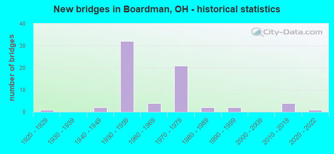
- New bridges - historical statistics
- 11920-1929
- 21940-1949
- 321950-1959
- 41960-1969
- 211970-1979
- 21980-1989
- 21990-1999
- 42010-2019
- 12020-2022
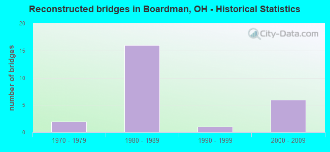
- Reconstructed bridges - Historical Statistics
- 21970-1979
- 161980-1989
- 11990-1999
- 62000-2009
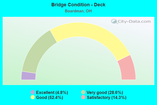
- Bridge Condition - Deck
- 4.8%Excellent
- 28.6%Very good
- 52.4%Good
- 14.3%Satisfactory
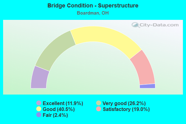
- Bridge Condition - Superstructure
- 11.9%Excellent
- 26.2%Very good
- 40.5%Good
- 19.0%Satisfactory
- 2.4%Fair
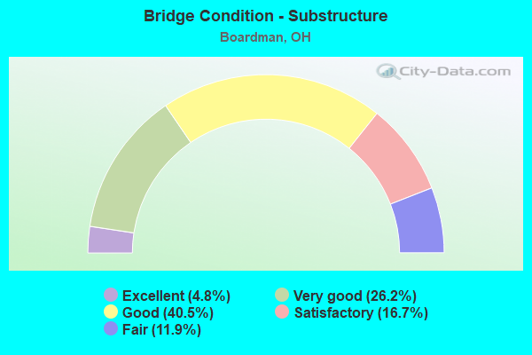
- Bridge Condition - Substructure
- 4.8%Excellent
- 26.2%Very good
- 40.5%Good
- 16.7%Satisfactory
- 11.9%Fair
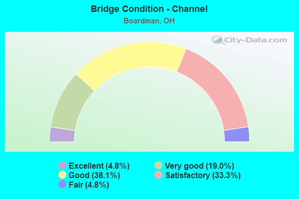
- Bridge Condition - Channel
- 4.8%Excellent
- 19.0%Very good
- 38.1%Good
- 33.3%Satisfactory
- 4.8%Fair
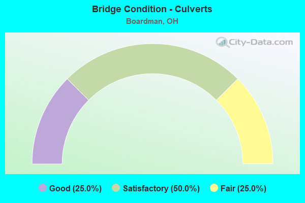
- Bridge Condition - Culverts
- 25.0%Good
- 50.0%Satisfactory
- 25.0%Fair
Find on map >> Show street view
Structure Number: 503607, Location: 0.8 Mi. S. of SR 224 (Lat: 41.005711, Lng: -80.672281), Route carried "on" structure: County highway 135, Year Built: 1961, Status: Open, Structure Length: 0.85m (2.79ft), Average Daily Traffic: 7,049 (year 2015), Truck Traffic: 5%, Average Future Daily Traffic: 9,784 (year 2035), Design Load: HS 20, Features Intersected: SAW MILL RUN, Facility Carried by Structure: Glenwood Ave.
Minimum Vertical Clearance: 30+ m (98+ ft), Kilometerpoint: 1.883, Lanes on structure: 4, Owner: County Highway Agency, Approaching Roadway Width: 21.3m (69.9ft), Material/Design: Steel, Design/Construction: Culvert, Number Of Spans In Main Unit: 2, Length of Maximum Span: 3.7m (12.1ft), Curb or Sidewalk Widths: Left: 0.0m, Right: 1.5m (4.9ft)
Condition: Channel: Satisfactory, Culverts: Satisfactory, Operating Rating: 97.2 metric tons, Method Used To Determine Operating Rating: Load Factor (LF) rating reported by rating factor (RF) method using MS18 loading, Inventory Rating: 68.0 metric tons, Method Used To Determine Inventory Rating: Load Factor (LF) rating reported by rating factor (RF) method using MS18 loading, Structural Evaluation: Equal to present minimum criteria, Waterway Adequacy: Equal to present desirable criteria, Approach Roadway Alignment: Equal to present desirable criteria, Length Of Structure Improvement: 1.52m (4.99ft), Designated Inspection Frequency: Every 12 months, Inspection Date: September 2021, Bridge Improvement Cost: $6,000, Roadway Improvement Cost: $1,000, Total Project Cost: $10,000
Find on map >> Show street view
Structure Number: 5036097, Location: over Park Drive (Lat: 41.052469, Lng: -80.672281), Route carried "on" structure: County highway 135, Year Built: 1952, Status: Open, Structure Length: 1.46m (4.79ft), Average Daily Traffic: 3,372 (year 2015), Truck Traffic: 2%, Average Future Daily Traffic: 4,680 (year 2035), Design Load: HS 15, Features Intersected: MILL CREEK PARK DRIVE, Facility Carried by Structure: Glenwood Ave
Minimum Vertical Clearance: 30+ m (98+ ft), Kilometerpoint: 7.145, Lanes on structure: 4, Lanes under structure: 2, Owner: County Highway Agency, Approaching Roadway Width: 19.5m (64.0ft), Skew: 20 degrees, Material/Design: Steel, Design/Construction: Stringer/Multi-beam, Number Of Spans In Main Unit: 1, Length of Maximum Span: 13.4m (44.0ft), Curb or Sidewalk Widths: Left: 1.5m (4.9ft), Right: 1.5m (4.9ft), Curb-To-Curb Width: 15.9m (52.2ft), Out-to-Out Width: 19.6m (64.3ft)
Condition: Deck: Satisfactory, Superstructure: Good, Substructure: Satisfactory, Operating Rating: 55.1 metric tons, Method Used To Determine Operating Rating: Load Factor (LF) rating reported by rating factor (RF) method using MS18 loading, Inventory Rating: 32.4 metric tons, Method Used To Determine Inventory Rating: Load Factor (LF) rating reported by rating factor (RF) method using MS18 loading, Structural Evaluation: Equal to present minimum criteria, Deck Geometry: Meets minimum limits, Underclear: Meets minimum limits, Approach Roadway Alignment: Better than present minimum criteria, Length Of Structure Improvement: 3.05m (10.01ft), Designated Inspection Frequency: Every 12 months, Inspection Date: September 2021, Bridge Improvement Cost: $74,000, Roadway Improvement Cost: $7,000, Total Project Cost: $90,000, Deck Structure Type: Concrete Cast-file-Place, Wearing Surface/Protective System: Wearing Surface: Bituminous
Find on map >> Show street view
Structure Number: 5036128, Location: 0.5 MI N OF SHIELDS AVE (Lat: 41.051561, Lng: -80.695500), Route carried "on" structure: County highway C0139, Year Built: 2020, Status: Open, Structure Length: 1.62m (5.31ft), Average Daily Traffic: 3,322 (year 2019), Truck Traffic: 47%, Average Future Daily Traffic: 3,519 (year 2039), Design Load: HL 93, Features Intersected: ANDERSONS RUN, Facility Carried by Structure: HOPKINS ROAD
Minimum Vertical Clearance: 30+ m (98+ ft), Kilometerpoint: 0.950, Lanes on structure: 2, Owner: County Highway Agency, Approaching Roadway Width: 7.3m (24.0ft), Skew: 1 degrees, Material/Design: Prestressed concrete, Design/Construction: Box Beam or Girders - Multiple, Number Of Spans In Main Unit: 1, Length of Maximum Span: 15.2m (49.9ft), Curb or Sidewalk Widths: Left: 9.1m (29.9ft), Right: 9.1m (29.9ft), Curb-To-Curb Width: 9.1m (29.9ft), Out-to-Out Width: 9.1m (29.9ft)
Condition: Deck: Excellent, Superstructure: Excellent, Substructure: Excellent, Channel: Excellent, Operating Rating: 55.1 metric tons, Method Used To Determine Operating Rating: Load and Resistance Factor Rating (LRFR) rating reported by rating factor(RF) method using HL-93 loadings, Inventory Rating: 42.1 metric tons, Method Used To Determine Inventory Rating: Load and Resistance Factor Rating (LRFR) rating reported by rating factor(RF) method using HL-93 loadings, Structural Evaluation: Superior to present desirable criteria, Deck Geometry: Meets minimum limits, Waterway Adequacy: Superior to present desirable criteria, Approach Roadway Alignment: Equal to present desirable criteria, Designated Inspection Frequency: Every 12 months, Inspection Date: September 2021, Deck Structure Type: Concrete Cast-file-Place, Wearing Surface/Protective System: Wearing Surface: Monolithic Concrete, Deck Protection: Epoxy Coated Reinforcing
Find on map >> Show street view
Structure Number: 5036135, Location: .2 Mi. N. of Shields Rd. (Lat: 41.048250, Lng: -80.685289), Route carried "on" structure: Other road 326, Year Built: 1968, Status: Open, Structure Length: 1.07m (3.51ft), Average Daily Traffic: 7,207 (year 2015), Truck Traffic: 5%, Average Future Daily Traffic: 10,003 (year 2035), Design Load: HS 20, Features Intersected: ANDERSONS RUN, Facility Carried by Structure: Sheban Dr.
Minimum Vertical Clearance: 30+ m (98+ ft), Kilometerpoint: 0.257, Lanes on structure: 2, Owner: County Highway Agency, Approaching Roadway Width: 10.4m (34.1ft), Material/Design: Steel, Design/Construction: Culvert, Number Of Spans In Main Unit: 2, Length of Maximum Span: 4.6m (15.1ft)
Condition: Channel: Satisfactory, Culverts: Fair, Operating Rating: 61.6 metric tons, Method Used To Determine Operating Rating: Load Factor (LF) rating reported by rating factor (RF) method using MS18 loading, Inventory Rating: 55.1 metric tons, Method Used To Determine Inventory Rating: Load Factor (LF) rating reported by rating factor (RF) method using MS18 loading, Structural Evaluation: Somewhat better than minimum adequacy, Waterway Adequacy: Equal to present desirable criteria, Approach Roadway Alignment: Equal to present desirable criteria, Length Of Structure Improvement: 1.52m (4.99ft), Designated Inspection Frequency: Every 12 months, Inspection Date: September 2021, Bridge Improvement Cost: $6,000, Roadway Improvement Cost: $1,000, Total Project Cost: $10,000
Find on map >> Show street view
Structure Number: 5036186, Location: .2 miles south of Shields (Lat: 41.044789, Lng: -80.677750), Route carried "on" structure: County highway 137, Year Built: 1981, Status: Open, Structure Length: 0.67m (2.20ft), Average Daily Traffic: 5,394 (year 2015), Truck Traffic: 5%, Average Future Daily Traffic: 7,487 (year 2035), Design Load: HS 20, Features Intersected: CRANBERRY RUN, Facility Carried by Structure: West Blvd.
Minimum Vertical Clearance: 30+ m (98+ ft), Kilometerpoint: 2.317, Lanes on structure: 2, Owner: County Highway Agency, Approaching Roadway Width: 12.2m (40.0ft), Skew: 3 degrees, Material/Design: Steel, Design/Construction: Culvert, Number Of Spans In Main Unit: 1, Length of Maximum Span: 6.7m (22.0ft)
Condition: Channel: Good, Culverts: Satisfactory, Operating Rating: 51.8 metric tons, Method Used To Determine Operating Rating: Load Factor (LF) rating reported by rating factor (RF) method using MS18 loading, Inventory Rating: 45.4 metric tons, Method Used To Determine Inventory Rating: Load Factor (LF) rating reported by rating factor (RF) method using MS18 loading, Structural Evaluation: Equal to present minimum criteria, Waterway Adequacy: Equal to present desirable criteria, Approach Roadway Alignment: Better than present minimum criteria, Length Of Structure Improvement: 3.05m (10.01ft), Designated Inspection Frequency: Every 12 months, Inspection Date: September 2021, Bridge Improvement Cost: $6,000, Roadway Improvement Cost: $1,000, Total Project Cost: $10,000
Find on map >> Show street view
Structure Number: 5038065, Location: 0.8MI.S OF S.R.224 (Lat: 41.013311, Lng: -80.711331), Route carried "on" structure: County highway 117, Year Built: 1925, Status: Posted for load, Structure Length: 1.62m (5.31ft), Average Daily Traffic: 8,620 (year 2015), Truck Traffic: 10%, Average Future Daily Traffic: 11,965 (year 2035), Features Intersected: INDIAN RUN CREEK, Facility Carried by Structure: TIPPECANOE RD.
Minimum Vertical Clearance: 30+ m (98+ ft), Kilometerpoint: 2.800, Lanes on structure: 2, Owner: County Highway Agency, Approaching Roadway Width: 9.8m (32.2ft), Material/Design: Concrete, Design/Construction: Tee Beam, Number Of Spans In Main Unit: 1, Length of Maximum Span: 14.9m (48.9ft), Curb-To-Curb Width: 7.0m (23.0ft), Out-to-Out Width: 8.1m (26.6ft)
Condition: Deck: Satisfactory, Superstructure: Fair, Substructure: Fair, Channel: Fair, Operating Rating: 35.6 metric tons, Method Used To Determine Operating Rating: Load Factor (LF) rating reported by rating factor (RF) method using MS18 loading, Inventory Rating: 19.4 metric tons, Method Used To Determine Inventory Rating: Load Factor (LF) rating reported by rating factor (RF) method using MS18 loading, Structural Evaluation: Meets minimum limits, Deck Geometry: High priority of replacement, Waterway Adequacy: Equal to present desirable criteria, Approach Roadway Alignment: Equal to present desirable criteria, Bridge Posting: Required (Relationship of Operating Rating to Maximum Legal Load: 0.1 - 9.9% below), Length Of Structure Improvement: 24.38m (79.99ft), Designated Inspection Frequency: Every 12 months, Inspection Date: September 2021, Bridge Improvement Cost: $400,000, Roadway Improvement Cost: $40,000, Total Project Cost: $500,000, Deck Structure Type: Concrete Cast-file-Place, Wearing Surface/Protective System: Wearing Surface: Bituminous
Find on map >> Show street view
Structure Number: 5038103, Location: 0.2MI.S OF S.R.62 (Lat: 41.059650, Lng: -80.711061), Route carried "on" structure: County highway 117, Year Built: 1940, Status: Open, Structure Length: 1.43m (4.69ft), Average Daily Traffic: 10,947 (year 2015), Truck Traffic: 10%, Average Future Daily Traffic: 15,194 (year 2035), Features Intersected: W BRANCH MILL CREEK, Facility Carried by Structure: TIPPECANOE RD.
Minimum Vertical Clearance: 30+ m (98+ ft), Kilometerpoint: 7.934, Lanes on structure: 2, Owner: County Highway Agency, Approaching Roadway Width: 9.1m (29.9ft), Material/Design: Concrete, Design/Construction: Frame, Number Of Spans In Main Unit: 1, Length of Maximum Span: 12.8m (42.0ft), Curb-To-Curb Width: 9.1m (29.9ft), Out-to-Out Width: 10.3m (33.8ft)
Condition: Deck: Satisfactory, Superstructure: Satisfactory, Substructure: Satisfactory, Channel: Satisfactory, Operating Rating: 40.8 metric tons, Method Used To Determine Operating Rating: Field evaluation and documented engineering judgment, Inventory Rating: 32.7 metric tons, Method Used To Determine Inventory Rating: Field evaluation and documented engineering judgment, Structural Evaluation: Equal to present minimum criteria, Deck Geometry: High priority of corrective action, Waterway Adequacy: Equal to present desirable criteria, Approach Roadway Alignment: Equal to present desirable criteria, Length Of Structure Improvement: 24.38m (79.99ft), Designated Inspection Frequency: Every 12 months, Inspection Date: September 2021, Bridge Improvement Cost: $165,000, Roadway Improvement Cost: $17,000, Total Project Cost: $200,000, Deck Structure Type: Concrete Cast-file-Place, Wearing Surface/Protective System: Wearing Surface: Bituminous
Find on map >> Show street view
Structure Number: 5056284, Location: 0.8MI.W OF SPRINFIELD (Lat: 40.958450, Lng: -80.628411), Route carried "on" structure: County highway 28, Year Built: 1947, Status: Open, Structure Length: 1.07m (3.51ft), Average Daily Traffic: 2,300 (year 2015), Truck Traffic: 7%, Average Future Daily Traffic: 3,192 (year 2035), Design Load: HS 15, Features Intersected: EVANS LAKE, Facility Carried by Structure: MIDDLETOWN RD.
Minimum Vertical Clearance: 30+ m (98+ ft), Kilometerpoint: 0.306, Lanes on structure: 2, Owner: County Highway Agency, Approaching Roadway Width: 8.5m (27.9ft), Material/Design: Concrete, Design/Construction: Tee Beam, Number Of Spans In Main Unit: 1, Length of Maximum Span: 9.1m (29.9ft), Curb-To-Curb Width: 7.2m (23.6ft), Out-to-Out Width: 8.4m (27.6ft)
Condition: Deck: Satisfactory, Superstructure: Satisfactory, Substructure: Good, Channel: Very good, Operating Rating: 81.0 metric tons, Method Used To Determine Operating Rating: Load Factor (LF) rating reported by rating factor (RF) method using MS18 loading, Inventory Rating: 77.8 metric tons, Method Used To Determine Inventory Rating: Load Factor (LF) rating reported by rating factor (RF) method using MS18 loading, Structural Evaluation: Equal to present minimum criteria, Deck Geometry: High priority of replacement, Waterway Adequacy: Equal to present desirable criteria, Approach Roadway Alignment: Equal to present desirable criteria, Length Of Structure Improvement: 15.24m (50.00ft), Designated Inspection Frequency: Every 12 months, Inspection Date: September 2021, Bridge Improvement Cost: $167,000, Roadway Improvement Cost: $17,000, Total Project Cost: $212,000, Deck Structure Type: Concrete Cast-file-Place, Wearing Surface/Protective System: Wearing Surface: Bituminous
Find on map >> Show street view
Structure Number: 5000033, Location: 0.3MI WEST OF EXIT 16 (Lat: 40.966531, Lng: -80.659431), Route carried "under" structure: State highway 7, Year Built: 1954, Structure Length: 0. m, Average Daily Traffic: 10,930 (year 2011), Truck Traffic: 10%, Features Intersected: TPK EXIT 232 RAMP
Minimum Vertical Clearance: 4.55m (14.93ft), Kilometerpoint: 7.580, Lanes on structure: 2, Lanes under structure: 4, Material/Design: Steel, Design/Construction: Stringer/Multi-beam, Length of Maximum Span: 26.8m (87.9ft)
Find on map >> Show street view
Structure Number: 5000394, Location: 2.03 MI N OF SR 165 (Lat: 40.973319, Lng: -80.720850), Route carried "under" structure: City street 30, Year Built: 1972, Structure Length: 0. m, Average Daily Traffic: 351 (year 2015), Truck Traffic: 7%, Features Intersected: SR 11, Facility Carried by Structure: SR 11
Minimum Vertical Clearance: 4.39m (14.40ft), Kilometerpoint: 5.166, Lanes on structure: 2, Lanes under structure: 2, Material/Design: Steel continuous, Design/Construction: Stringer/Multi-beam, Length of Maximum Span: 13.4m (44.0ft)
Find on map >> Show street view
Structure Number: 5000424, Location: 2.03 MI N OF SR 165 (Lat: 40.973331, Lng: -80.720350), Route carried "under" structure: City street 30, Year Built: 1972, Structure Length: 0. m, Average Daily Traffic: 351 (year 2015), Truck Traffic: 7%, Features Intersected: SR 11, Facility Carried by Structure: SR 11
Minimum Vertical Clearance: 4.70m (15.42ft), Kilometerpoint: 5.198, Lanes on structure: 2, Lanes under structure: 2, Material/Design: Steel continuous, Design/Construction: Stringer/Multi-beam, Length of Maximum Span: 13.4m (44.0ft)
Find on map >> Show street view
Structure Number: 500323, Location: SR164 over IR680 (Lat: 40.960561, Lng: -80.639719), Route carried "under" structure: Interstate 680, Year Built: 2016, Structure Length: 0. m, Average Daily Traffic: 5,661 (year 2015), Truck Traffic: 8%, Features Intersected: SR164, Facility Carried by Structure: SR 164
Minimum Vertical Clearance: 5.25m (17.22ft), Kilometerpoint: 26.264, Lanes on structure: 2, Lanes under structure: 4, Material/Design: Steel continuous, Design/Construction: Stringer/Multi-beam, Length of Maximum Span: 30.9m (101.4ft)
Find on map >> Show street view
Structure Number: 5003253, Location: 2.56 MI S OF US 224 (Lat: 40.987839, Lng: -80.632089), Route carried "under" structure: Interstate 680, Year Built: 1974, Structure Length: 0. m, Average Daily Traffic: 4,878 (year 2015), Truck Traffic: 8%, Features Intersected: SR164(NEAR WSTRNRESRV RD, Facility Carried by Structure: SR 164
Minimum Vertical Clearance: 4.93m (16.17ft), Kilometerpoint: 23.126, Lanes on structure: 5, Lanes under structure: 4, Material/Design: Steel continuous, Design/Construction: Stringer/Multi-beam, Length of Maximum Span: 26.2m (86.0ft)
Find on map >> Show street view
Structure Number: 5004853, Location: 0.60 MI W OF SR 170 (Lat: 41.024250, Lng: -80.627250), Route carried "under" structure: Interstate 680, Year Built: 1974, Structure Length: 0. m, Average Daily Traffic: 18,378 (year 2015), Truck Traffic: 8%, Features Intersected: SR 224, Facility Carried by Structure: US 224
Minimum Vertical Clearance: 4.98m (16.34ft), Kilometerpoint: 19.006, Lanes on structure: 5, Lanes under structure: 6, Material/Design: Steel continuous, Design/Construction: Stringer/Multi-beam, Length of Maximum Span: 28.7m (94.2ft)
Find on map >> Show street view
Structure Number: 5007615, Location: 0.61 MI S OF SR 625 (Lat: 41.050969, Lng: -80.630181), Route carried "under" structure: Interstate 680, Year Built: 1974, Structure Length: 0. m, Average Daily Traffic: 36,813 (year 2015), Truck Traffic: 8%, Features Intersected: UNDER THALIA AVE TR-1682, Facility Carried by Structure: THALIA AVENUE
Minimum Vertical Clearance: 5.26m (17.26ft), Kilometerpoint: 15.933, Lanes on structure: 2, Lanes under structure: 6, Material/Design: Steel continuous, Design/Construction: Stringer/Multi-beam, Length of Maximum Span: 25.0m (82.0ft)
Find on map >> Show street view
Structure Number: 5007712, Location: 1.06 MI N OF US 224 (Lat: 41.039050, Lng: -80.631150), Route carried "under" structure: Bypass County highway 102, Year Built: 1974, Structure Length: 0. m, Average Daily Traffic: 8,519 (year 2015), Truck Traffic: 5%, Features Intersected: I 680 WB, Facility Carried by Structure: I.R. 680
Minimum Vertical Clearance: 4.57m (14.99ft), Kilometerpoint: 2.881, Lanes on structure: 3, Lanes under structure: 2, Material/Design: Steel continuous, Design/Construction: Stringer/Multi-beam, Length of Maximum Span: 13.1m (43.0ft)
Find on map >> Show street view
Structure Number: 500772, Location: 1.06 MI N OF US 224 (Lat: 41.039111, Lng: -80.631581), Route carried "under" structure: Bypass County highway 102, Year Built: 1974, Structure Length: 0. m, Average Daily Traffic: 8,519 (year 2015), Truck Traffic: 5%, Features Intersected: IR 680 EB, Facility Carried by Structure: I.R. 680
Minimum Vertical Clearance: 4.57m (14.99ft), Kilometerpoint: 2.849, Lanes on structure: 3, Lanes under structure: 2, Material/Design: Steel continuous, Design/Construction: Stringer/Multi-beam, Length of Maximum Span: 13.1m (43.0ft)
Find on map >> Show street view
Structure Number: 500786, Location: 0.92 MI W OF SR 164 (Lat: 40.973431, Lng: -80.636069), Route carried "under" structure: County highway 30, Year Built: 1975, Structure Length: 0. m, Average Daily Traffic: 590 (year 2015), Truck Traffic: 7%, Features Intersected: IR680, Facility Carried by Structure: I.R. 680
Minimum Vertical Clearance: 4.42m (14.50ft), Kilometerpoint: 20.954, Lanes on structure: 2, Lanes under structure: 2, Material/Design: Steel continuous, Design/Construction: Stringer/Multi-beam, Length of Maximum Span: 14.5m (47.6ft)
Find on map >> Show street view
Structure Number: 5007879, Location: 0.92 MI W OF SR 164 (Lat: 40.973461, Lng: -80.636600), Route carried "under" structure: County highway 30, Year Built: 1975, Structure Length: 0. m, Average Daily Traffic: 590 (year 2015), Truck Traffic: 7%, Features Intersected: IR680, Facility Carried by Structure: I.R. 680
Minimum Vertical Clearance: 4.44m (14.57ft), Kilometerpoint: 20.954, Lanes on structure: 2, Lanes under structure: 2, Material/Design: Steel continuous, Design/Construction: Stringer/Multi-beam, Length of Maximum Span: 14.3m (46.9ft)
Find on map >> Show street view
Structure Number: 5029481, Location: 5.3MI WEST OF EXIT 16 (Lat: 41.024650, Lng: -80.723489), Route carried "under" structure: Interstate 76K, Year Built: 1954, Structure Length: 0. m, Average Daily Traffic: 21,343 (year 2015), Truck Traffic: 28%, Features Intersected: US224, Facility Carried by Structure: I76 OH TPK
Minimum Vertical Clearance: 5.03m (16.50ft), Kilometerpoint: 13.744, Lanes on structure: 5, Lanes under structure: 4, Toll: On toll road, Material/Design: Steel continuous, Design/Construction: Stringer/Multi-beam, Length of Maximum Span: 22.6m (74.1ft)
Find on map >> Show street view
Structure Number: 5029511, Location: 4.5MI WEST OF EXIT 16 (Lat: 41.015989, Lng: -80.711531), Route carried "under" structure: County highway 117, Year Built: 1954, Structure Length: 0. m, Average Daily Traffic: 8,620 (year 2015), Truck Traffic: 10%, Features Intersected: I76 OHIO TPK WB, Facility Carried by Structure: TIPPECANOE RD
Minimum Vertical Clearance: 4.27m (14.01ft), Kilometerpoint: 3.026, Lanes on structure: 2, Lanes under structure: 2, Material/Design: Steel continuous, Design/Construction: Stringer/Multi-beam, Length of Maximum Span: 19.5m (64.0ft)
Find on map >> Show street view
Structure Number: 5029538, Location: 4.5MI WEST OF EXIT 16 (Lat: 41.016369, Lng: -80.711531), Route carried "under" structure: County highway 117, Year Built: 1954, Structure Length: 0. m, Average Daily Traffic: 8,620 (year 2015), Truck Traffic: 10%, Features Intersected: I76 OHIO TPK WB, Facility Carried by Structure: TIPPECANOE RD
Minimum Vertical Clearance: 5.28m (17.32ft), Kilometerpoint: 3.074, Lanes on structure: 2, Lanes under structure: 2, Material/Design: Steel continuous, Design/Construction: Stringer/Multi-beam, Length of Maximum Span: 19.5m (64.0ft)
Find on map >> Show street view
Structure Number: 5029619, Location: 2.2MI WEST OF EXIT 16 (Lat: 40.988131, Lng: -80.688361), Route carried "under" structure: County highway 32, Year Built: 1954, Structure Length: 0. m, Average Daily Traffic: 100 (year 1970), Features Intersected: I76 OHIO TPK, Facility Carried by Structure: WESTERN RES RD
Minimum Vertical Clearance: 4.47m (14.67ft), Kilometerpoint: 27.005, Lanes on structure: 2, Lanes under structure: 2, Material/Design: Steel continuous, Design/Construction: Stringer/Multi-beam, Length of Maximum Span: 14.0m (45.9ft)
Find on map >> Show street view
Structure Number: 5029627, Location: 2.2MI WEST OF EXIT 16 (Lat: 40.988139, Lng: -80.688011), Route carried "under" structure: County highway 32, Year Built: 1954, Structure Length: 0. m, Average Daily Traffic: 100 (year 1970), Truck Traffic: 10%, Features Intersected: I76 OHIO TPK, Facility Carried by Structure: WESTERN RES RD
Minimum Vertical Clearance: 4.57m (14.99ft), Kilometerpoint: 27.037, Lanes on structure: 2, Lanes under structure: 2, Material/Design: Steel continuous, Design/Construction: Stringer/Multi-beam, Length of Maximum Span: 14.0m (45.9ft)
Find on map >> Show street view
Structure Number: 5029635, Location: AT EXIT 234 (Lat: 40.955239, Lng: -80.639900), Route carried "under" structure: Interstate 76K, Year Built: 1975, Structure Length: 0. m, Average Daily Traffic: 12,030 (year 1972), Features Intersected: EB TPK EXIT 234 RP, Facility Carried by Structure: I76 TPK
Minimum Vertical Clearance: 5.01m (16.44ft), Kilometerpoint: 24.253, Lanes on structure: 1, Lanes under structure: 4, Toll: On toll road, Material/Design: Steel continuous, Design/Construction: Stringer/Multi-beam, Length of Maximum Span: 24.1m (79.1ft)
Find on map >> Show street view
Structure Number: 5029678, Location: 0.9MI WEST OF EXIT 16 (Lat: 40.975100, Lng: -80.669519), Route carried "under" structure: County highway 143, Year Built: 1954, Structure Length: 0. m, Average Daily Traffic: 100 (year 1970), Features Intersected: I76 OHIO TPK, Facility Carried by Structure: SHARROTT RD
Minimum Vertical Clearance: 4.29m (14.07ft), Kilometerpoint: 1.416, Lanes on structure: 2, Lanes under structure: 2, Material/Design: Steel continuous, Design/Construction: Stringer/Multi-beam, Length of Maximum Span: 12.8m (42.0ft)
Find on map >> Show street view
Structure Number: 5029686, Location: 0.9MI WEST OF EXIT 16 (Lat: 40.975361, Lng: -80.669519), Route carried "under" structure: County highway 143, Year Built: 1954, Structure Length: 0. m, Average Daily Traffic: 100 (year 1970), Truck Traffic: 10%, Features Intersected: I76 OHIO TPK, Facility Carried by Structure: SHARROTT RD
Minimum Vertical Clearance: 5.44m (17.85ft), Kilometerpoint: 1.384, Lanes on structure: 2, Lanes under structure: 2, Material/Design: Steel continuous, Design/Construction: Stringer/Multi-beam, Length of Maximum Span: 13.1m (43.0ft)
Find on map >> Show street view
Structure Number: 5029708, Location: 0.3MI WEST OF EXIT 16 (Lat: 40.970611, Lng: -80.660981), Route carried "under" structure: State highway 7, Year Built: 1954, Structure Length: 0. m, Average Daily Traffic: 10,930 (year 2011), Truck Traffic: 11%, Features Intersected: I76 OHIO TPK EB
Minimum Vertical Clearance: 5.08m (16.67ft), Kilometerpoint: 8.015, Lanes on structure: 2, Lanes under structure: 4, Material/Design: Steel, Design/Construction: Stringer/Multi-beam, Length of Maximum Span: 33.2m (108.9ft)
Find on map >> Show street view
Structure Number: 5029716, Location: 0.3MI WEST OF EXIT 16 (Lat: 40.970939, Lng: -80.661081), Route carried "under" structure: State highway 7, Year Built: 1954, Structure Length: 0. m, Average Daily Traffic: 10,930 (year 2011), Truck Traffic: 11%, Features Intersected: I76 OHIO TPK WB
Minimum Vertical Clearance: 4.55m (14.93ft), Kilometerpoint: 8.031, Lanes on structure: 2, Lanes under structure: 4, Material/Design: Steel, Design/Construction: Stringer/Multi-beam, Length of Maximum Span: 32.9m (107.9ft)
Find on map >> Show street view
Structure Number: 5029784, Location: 1.2 miles east of SR 7 (Lat: 40.957911, Lng: -80.643489), Route carried "under" structure: Interstate 76K, Year Built: 2019, Structure Length: 0. m, Average Daily Traffic: 21,778 (year 2019), Truck Traffic: 30%, Features Intersected: SR164/SOUTH AVE, Facility Carried by Structure: I76 TURNPIKE
Minimum Vertical Clearance: 4.94m (16.21ft), Kilometerpoint: 23.863, Lanes on structure: 3, Lanes under structure: 4, Toll: On toll road, Material/Design: Steel continuous, Design/Construction: Stringer/Multi-beam, Length of Maximum Span: 22.9m (75.1ft)
Find on map >> Show street view
Structure Number: 5036097, Location: over Park Drive (Lat: 41.052469, Lng: -80.672281), Route carried "under" structure: City street 132, Year Built: 1952, Structure Length: 0. m, Average Daily Traffic: 1,295 (year 2015), Truck Traffic: 5%, Features Intersected: GLENWOOD AVE CH135, Facility Carried by Structure: Glenwood Ave
Minimum Vertical Clearance: 5.44m (17.85ft), Kilometerpoint: 0.000, Lanes on structure: 4, Lanes under structure: 2, Material/Design: Steel, Design/Construction: Stringer/Multi-beam, Length of Maximum Span: 13.4m (44.0ft)