Bridge Statistics for Big Beaver, Pennsylvania (PA)
Condition, Traffic, Stress, Structural Evaluation, Project Costs
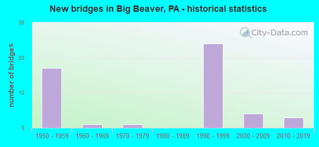
- New bridges - historical statistics
- 171950-1959
- 11960-1969
- 11970-1979
- 241990-1999
- 42000-2009
- 32010-2019

- Reconstructed bridges - Historical Statistics
- 21970-1979
- 41980-1989
- 11990-1999
- 12000-2009


- Bridge Condition - Deck
- 7.1%Very good
- 53.6%Good
- 35.7%Satisfactory
- 3.6%Fair

- Bridge Condition - Superstructure
- 14.3%Very good
- 50.0%Good
- 28.6%Satisfactory
- 7.1%Fair

- Bridge Condition - Substructure
- 3.6%Very good
- 57.1%Good
- 32.1%Satisfactory
- 7.1%Fair

- Bridge Condition - Channel
- 33.3%Excellent
- 16.7%Very good
- 25.0%Good
- 25.0%Fair
Find on map >> Show street view
Structure Number: 38, Location: SW OF GETTYSBURG (Lat: 39.735436, Lng: -77.373006), Route carried "on" structure: State highway 16, Year Built: 1952, Status: Open, Structure Length: 1.52m (4.99ft), Average Daily Traffic: 6,232 (year 2022), Truck Traffic: 11%, Average Future Daily Traffic: 7,815 (year 2032), Design Load: HS 20, Features Intersected: MINEY BRANCH
Minimum Vertical Clearance: 30+ m (98+ ft), Kilometerpoint: 7.002, Lanes on structure: 2, Owner: State Highway Agency, Approaching Roadway Width: 9.8m (32.2ft), Skew: 3 degrees, Material/Design: Concrete, Design/Construction: Tee Beam, Number Of Spans In Main Unit: 1, Length of Maximum Span: 13.7m (44.9ft), Curb or Sidewalk Widths: Left: 0.2m (0.7ft), Right: 0.2m (0.7ft), Curb-To-Curb Width: 11.6m (38.1ft), Out-to-Out Width: 12.7m (41.7ft)
Condition: Deck: Satisfactory, Superstructure: Satisfactory, Substructure: Fair, Channel: Fair, Operating Rating: 64.4 metric tons, Method Used To Determine Operating Rating: Load Factor (LF), Inventory Rating: 38.1 metric tons, Method Used To Determine Inventory Rating: Load Factor (LF), Structural Evaluation: Somewhat better than minimum adequacy, Deck Geometry: Somewhat better than minimum adequacy, Waterway Adequacy: Equal to present desirable criteria, Approach Roadway Alignment: Equal to present desirable criteria, Length Of Structure Improvement: 2.20m (7.22ft), Designated Inspection Frequency: Every 24 months, Inspection Date: November 2020, Bridge Improvement Cost: $19,000, Roadway Improvement Cost: $57,000, Total Project Cost: $261,000, Deck Structure Type: Concrete Cast-file-Place, Wearing Surface/Protective System: Wearing Surface: Bituminous, Membrane: Preformed Fabric
Find on map >> Show street view
Structure Number: 3455, Location: 3200' NORTH OF SR 0551 (Lat: 40.798200, Lng: -80.334700), Route carried "on" structure: State highway 18, Year Built: 1950, Year Reconstructed: 1995, Status: Open, Structure Length: 15.42m (50.59ft), Average Daily Traffic: 10,717 (year 2021), Truck Traffic: 7%, Average Future Daily Traffic: 13,112 (year 2032), Design Load: H 20, Features Intersected: TRIB TO WALLACE RUN, Facility Carried by Structure: BIG BEAVER BLVD
Minimum Vertical Clearance: 30+ m (98+ ft), Kilometerpoint: 47.001, Lanes on structure: 4, Base Highway Network: Yes, Owner: State Highway Agency, Approaching Roadway Width: 19.2m (63.0ft), Skew: 30 degrees, Material/Design: Steel, Design/Construction: Stringer/Multi-beam, Number Of Spans In Main Unit: 5, Length of Maximum Span: 24.4m (80.1ft), Curb or Sidewalk Widths: Left: 0.2m (0.7ft), Right: 0.2m (0.7ft), Curb-To-Curb Width: 18.8m (61.7ft), Out-to-Out Width: 20.8m (68.2ft)
Condition: Deck: Satisfactory, Superstructure: Fair, Substructure: Satisfactory, Channel: Good, Inventory Rating: 71.7 metric tons, Method Used To Determine Inventory Rating: Load Factor (LF), Structural Evaluation: Somewhat better than minimum adequacy, Deck Geometry: Equal to present minimum criteria, Waterway Adequacy: Superior to present desirable criteria, Approach Roadway Alignment: Equal to present desirable criteria, Length Of Structure Improvement: 15.40m (50.52ft), Designated Inspection Frequency: Every 24 months, Inspection Date: September 2020, Bridge Improvement Cost: $51,000, Roadway Improvement Cost: $149,000, Total Project Cost: $683,000, Deck Structure Type: Concrete Cast-file-Place, Wearing Surface/Protective System: Wearing Surface: Latex Concrete, Membrane: Other, Deck Protection: Epoxy Coated Reinforcing
Find on map >> Show street view
Structure Number: 3497, Location: SR 51 OVER TR 4013 (Lat: 40.795000, Lng: -80.420000), Route carried "on" structure: State highway 51, Year Built: 1953, Year Reconstructed: 1977, Status: Open, Structure Length: 4.57m (14.99ft), Average Daily Traffic: 15,260 (year 2022), Truck Traffic: 6%, Average Future Daily Traffic: 9,727 (year 2032), Design Load: HS 20, Features Intersected: TR 4013, Facility Carried by Structure: PENNSYLVANIA AV
Minimum Vertical Clearance: 30+ m (98+ ft), Kilometerpoint: 33.178, Lanes on structure: 4, Lanes under structure: 2, Base Highway Network: Yes, Owner: State Highway Agency, Approaching Roadway Width: 21.9m (71.9ft), Skew: 23 degrees, Material/Design: Steel continuous, Design/Construction: Stringer/Multi-beam, Number Of Spans In Main Unit: 3, Length of Maximum Span: 17.1m (56.1ft), Curb or Sidewalk Widths: Left: 0.2m (0.7ft), Right: 0.2m (0.7ft), Curb-To-Curb Width: 26.2m (86.0ft), Out-to-Out Width: 27.4m (89.9ft)
Condition: Deck: Good, Superstructure: Satisfactory, Substructure: Satisfactory, Operating Rating: 69.9 metric tons, Method Used To Determine Operating Rating: Load Factor (LF), Inventory Rating: 41.7 metric tons, Method Used To Determine Inventory Rating: Load Factor (LF), Structural Evaluation: Equal to present minimum criteria, Deck Geometry: Superior to present desirable criteria, Underclear: Meets minimum limits, Approach Roadway Alignment: Equal to present desirable criteria, Length Of Structure Improvement: 4.60m (15.09ft), Designated Inspection Frequency: Every 24 months, Inspection Date: August 2021, Bridge Improvement Cost: $89,000, Roadway Improvement Cost: $261,000, Total Project Cost: $1,198,000, Deck Structure Type: Concrete Cast-file-Place, Wearing Surface/Protective System: Wearing Surface: Latex Concrete, Deck Protection: Epoxy Coated Reinforcing
Find on map >> Show street view
Structure Number: 3617, Location: 300' S.W. OF PA TURNPIKE (Lat: 40.840186, Lng: -80.388050), Route carried "on" structure: State highway 351, Year Built: 1951, Status: Open, Structure Length: 0.73m (2.40ft), Average Daily Traffic: 1,453 (year 2021), Truck Traffic: 16%, Average Future Daily Traffic: 2,559 (year 2032), Design Load: HS 20, Features Intersected: JORDAN RUN, Facility Carried by Structure: FAIRLANE BL
Minimum Vertical Clearance: 30+ m (98+ ft), Kilometerpoint: 5.435, Lanes on structure: 2, Owner: State Highway Agency, Approaching Roadway Width: 11.0m (36.1ft), Skew: 4 degrees, Material/Design: Concrete, Design/Construction: Culvert, Number Of Spans In Main Unit: 1, Length of Maximum Span: 7.3m (24.0ft)
Condition: Channel: Fair, Culverts: Satisfactory, Operating Rating: 49.0 metric tons, Method Used To Determine Operating Rating: Field evaluation and documented engineering judgment, Inventory Rating: 32.7 metric tons, Method Used To Determine Inventory Rating: Field evaluation and documented engineering judgment, Structural Evaluation: Equal to present minimum criteria, Waterway Adequacy: Better than present minimum criteria, Approach Roadway Alignment: Equal to present desirable criteria, Length Of Structure Improvement: 0.70m (2.30ft), Designated Inspection Frequency: Every 24 months, Inspection Date: March 2021
Find on map >> Show street view
Structure Number: 3737, Location: 1.5 MI. N.JUNC.168&551 (Lat: 40.826517, Lng: -80.411186), Route carried "on" structure: State highway , Year Built: 1962, Year Reconstructed: 2012, Status: Open, Structure Length: 4.60m (15.09ft), Average Daily Traffic: 882 (year 2022), Truck Traffic: 2%, Average Future Daily Traffic: 1,121 (year 2032), Design Load: HL 93, Features Intersected: N.FORK LITTLE BEAVER CR., Facility Carried by Structure: NEW GALILEE RD
Minimum Vertical Clearance: 30+ m (98+ ft), Kilometerpoint: 1.257, Lanes on structure: 2, Owner: State Highway Agency, Approaching Roadway Width: 12.8m (42.0ft), Skew: 2 degrees, Material/Design: Prestressed concrete, Design/Construction: Box Beam or Girders - Multiple, Number Of Spans In Main Unit: 2, Length of Maximum Span: 22.6m (74.1ft), Curb or Sidewalk Widths: Left: 0.5m (1.6ft), Right: 0.5m (1.6ft), Curb-To-Curb Width: 11.7m (38.4ft), Out-to-Out Width: 13.4m (44.0ft)
Condition: Deck: Very good, Superstructure: Very good, Substructure: Good, Channel: Fair, Operating Rating: 53.8 metric tons, Method Used To Determine Operating Rating: Assigned ratings based on Load and Resistance Factor Design (LRFD) reported by rating factor (RF) using HL93 loadings, Inventory Rating: 41.5 metric tons, Method Used To Determine Inventory Rating: Assigned ratings based on Load and Resistance Factor Design (LRFD) reported by rating factor (RF) using HL93 loadings, Structural Evaluation: Better than present minimum criteria, Deck Geometry: Better than present minimum criteria, Waterway Adequacy: Superior to present desirable criteria, Approach Roadway Alignment: Equal to present desirable criteria, Length Of Structure Improvement: 4.60m (15.09ft), Designated Inspection Frequency: Every 24 months, Inspection Date: September 2021, Bridge Improvement Cost: $3,000, Roadway Improvement Cost: $25,000, Total Project Cost: $35,000, Wearing Surface/Protective System: Wearing Surface: Bituminous
Find on map >> Show street view
Structure Number: 3738, Location: SR 4006 / SR 4001 INTER. (Lat: 40.816806, Lng: -80.375328), Route carried "on" structure: State highway , Year Built: 1976, Status: Open, Structure Length: 5.67m (18.60ft), Average Daily Traffic: 976 (year 2022), Truck Traffic: 1%, Average Future Daily Traffic: 885 (year 2032), Design Load: HS 20, Features Intersected: NORFOLK SOUTHERN RR, Facility Carried by Structure: SHENANGO ROAD
Minimum Vertical Clearance: 30+ m (98+ ft), Kilometerpoint: 0.000, Lanes on structure: 2, Owner: State Highway Agency, Approaching Roadway Width: 13.4m (44.0ft), Material/Design: Steel continuous, Design/Construction: Frame, Number Of Spans In Main Unit: 3, Length of Maximum Span: 41.1m (134.8ft), Curb or Sidewalk Widths: Left: 0.2m (0.7ft), Right: 0.2m (0.7ft), Curb-To-Curb Width: 13.4m (44.0ft), Out-to-Out Width: 14.5m (47.6ft)
Condition: Deck: Satisfactory, Superstructure: Satisfactory, Substructure: Satisfactory, Operating Rating: 42.6 metric tons, Method Used To Determine Operating Rating: Load Factor (LF), Inventory Rating: 25.4 metric tons, Method Used To Determine Inventory Rating: Load Factor (LF), Structural Evaluation: Equal to present minimum criteria, Deck Geometry: Superior to present desirable criteria, Underclear: High priority of corrective action, Approach Roadway Alignment: Equal to present desirable criteria, Length Of Structure Improvement: 5.70m (18.70ft), Designated Inspection Frequency: Every 24 months, Critical Feature Inspection Frequency: Every 24 months, Inspection Date: July 2020, Critical Feature Inspection Date: July 2020, Deck Structure Type: Concrete Cast-file-Place, Wearing Surface/Protective System: Wearing Surface: Monolithic Concrete
Find on map >> Show street view
Structure Number: 3796, Location: BIG BEAVER BOROUGH (Lat: 40.795000, Lng: -80.360000), Route carried "on" structure: Other road 60, Year Built: 1992, Status: Open, Structure Length: 10.18m (33.40ft), Average Daily Traffic: 9,871 (year 1998), Truck Traffic: 12%, Average Future Daily Traffic: 14,459 (year 2030), Design Load: HS 25 or greater, Features Intersected: SR 0551, Facility Carried by Structure: PA TPK (I-376)
Minimum Vertical Clearance: 30+ m (98+ ft), Kilometerpoint: 0.000, Lanes on structure: 2, Lanes under structure: 3, Base Highway Network: Yes, Toll: On toll road, Owner: State Toll Authority, Approaching Roadway Width: 12.5m (41.0ft), Skew: 19 degrees, Material/Design: Steel continuous, Design/Construction: Stringer/Multi-beam, Number Of Spans In Main Unit: 2, Length of Maximum Span: 50.9m (167.0ft), Curb or Sidewalk Widths: Left: 0.2m (0.7ft), Right: 0.2m (0.7ft), Curb-To-Curb Width: 12.8m (42.0ft), Out-to-Out Width: 13.9m (45.6ft)
Condition: Deck: Good, Superstructure: Good, Substructure: Good, Channel: Very good, Operating Rating: 78.9 metric tons, Method Used To Determine Operating Rating: Load Factor (LF), Inventory Rating: 47.2 metric tons, Method Used To Determine Inventory Rating: Load Factor (LF), Structural Evaluation: Better than present minimum criteria, Deck Geometry: Equal to present desirable criteria, Underclear: Superior to present desirable criteria, Waterway Adequacy: Superior to present desirable criteria, Approach Roadway Alignment: Equal to present desirable criteria, Designated Inspection Frequency: Every 48 months, Inspection Date: October 2019, Deck Structure Type: Concrete Cast-file-Place, Wearing Surface/Protective System: Wearing Surface: Monolithic Concrete, Deck Protection: Epoxy Coated Reinforcing
Find on map >> Show street view
Structure Number: 3797, Location: BIG BEAVER BOROUGH (Lat: 40.795000, Lng: -80.361667), Route carried "on" structure: Other road 60, Year Built: 1992, Status: Open, Structure Length: 10.12m (33.20ft), Average Daily Traffic: 9,871 (year 1998), Truck Traffic: 12%, Average Future Daily Traffic: 14,459 (year 2030), Design Load: HS 25 or greater, Features Intersected: SR 0551, Facility Carried by Structure: PA TPK (I-376)
Minimum Vertical Clearance: 30+ m (98+ ft), Kilometerpoint: 0.000, Lanes on structure: 2, Lanes under structure: 3, Base Highway Network: Yes, Toll: On toll road, Owner: State Toll Authority, Approaching Roadway Width: 12.8m (42.0ft), Skew: 13 degrees, Material/Design: Steel continuous, Design/Construction: Stringer/Multi-beam, Number Of Spans In Main Unit: 2, Length of Maximum Span: 50.6m (166.0ft), Curb or Sidewalk Widths: Left: 0.2m (0.7ft), Right: 0.2m (0.7ft), Curb-To-Curb Width: 12.8m (42.0ft), Out-to-Out Width: 13.9m (45.6ft)
Condition: Deck: Good, Superstructure: Good, Substructure: Good, Channel: Very good, Operating Rating: 80.7 metric tons, Method Used To Determine Operating Rating: Load Factor (LF), Inventory Rating: 48.1 metric tons, Method Used To Determine Inventory Rating: Load Factor (LF), Structural Evaluation: Better than present minimum criteria, Deck Geometry: Equal to present desirable criteria, Underclear: Superior to present desirable criteria, Waterway Adequacy: Superior to present desirable criteria, Approach Roadway Alignment: Equal to present desirable criteria, Designated Inspection Frequency: Every 48 months, Inspection Date: October 2019, Deck Structure Type: Concrete Cast-file-Place, Wearing Surface/Protective System: Wearing Surface: Monolithic Concrete, Deck Protection: Epoxy Coated Reinforcing
Find on map >> Show street view
Structure Number: 3798, Location: BIG BEAVER BOROUGH (Lat: 40.801844, Lng: -80.361564), Route carried "on" structure: State highway , Year Built: 1992, Status: Open, Structure Length: 9.63m (31.59ft), Average Daily Traffic: 597 (year 2022), Truck Traffic: 5%, Average Future Daily Traffic: 2,089 (year 2032), Design Load: HS 20, Features Intersected: PA TURNPIKE BV-109, Facility Carried by Structure: FRIENDSHIP ROAD
Minimum Vertical Clearance: 30+ m (98+ ft), Kilometerpoint: 1.912, Lanes on structure: 2, Lanes under structure: 6, Owner: State Highway Agency, Approaching Roadway Width: 11.9m (39.0ft), Skew: 3 degrees, Material/Design: Steel continuous, Design/Construction: Stringer/Multi-beam, Number Of Spans In Main Unit: 2, Length of Maximum Span: 51.8m (169.9ft), Curb or Sidewalk Widths: Left: 0.2m (0.7ft), Right: 0.2m (0.7ft), Curb-To-Curb Width: 11.6m (38.1ft), Out-to-Out Width: 12.6m (41.3ft)
Condition: Deck: Satisfactory, Superstructure: Good, Substructure: Good, Operating Rating: 45.4 metric tons, Method Used To Determine Operating Rating: Load Factor (LF), Inventory Rating: 27.2 metric tons, Method Used To Determine Inventory Rating: Load Factor (LF), Structural Evaluation: Equal to present minimum criteria, Deck Geometry: Better than present minimum criteria, Underclear: Better than present minimum criteria, Approach Roadway Alignment: Equal to present desirable criteria, Length Of Structure Improvement: 10.20m (33.46ft), Designated Inspection Frequency: Every 24 months, Inspection Date: July 2020, Deck Structure Type: Concrete Cast-file-Place, Wearing Surface/Protective System: Wearing Surface: Monolithic Concrete, Deck Protection: Epoxy Coated Reinforcing
Find on map >> Show street view
Structure Number: 3799, Location: BIG BEAVER BOROUGH (Lat: 40.820617, Lng: -80.371392), Route carried "on" structure: Other road 60, Year Built: 1992, Status: Open, Structure Length: 8.84m (29.00ft), Average Daily Traffic: 9,871 (year 1998), Truck Traffic: 12%, Average Future Daily Traffic: 14,459 (year 2030), Design Load: HS 25 or greater, Features Intersected: SR 4001, NFS RR, Facility Carried by Structure: PA TPK ( I-376)
Minimum Vertical Clearance: 30+ m (98+ ft), Kilometerpoint: 0.000, Lanes on structure: 2, Lanes under structure: 2, Base Highway Network: Yes, Toll: On toll road, Owner: State Toll Authority, Approaching Roadway Width: 12.8m (42.0ft), Skew: 10 degrees, Material/Design: Steel continuous, Design/Construction: Stringer/Multi-beam, Number Of Spans In Main Unit: 2, Length of Maximum Span: 45.7m (149.9ft), Curb or Sidewalk Widths: Left: 0.2m (0.7ft), Right: 0.2m (0.7ft), Curb-To-Curb Width: 12.8m (42.0ft), Out-to-Out Width: 13.9m (45.6ft)
Condition: Deck: Good, Superstructure: Good, Substructure: Satisfactory, Channel: Excellent, Operating Rating: 74.4 metric tons, Method Used To Determine Operating Rating: Load Factor (LF), Inventory Rating: 44.5 metric tons, Method Used To Determine Inventory Rating: Load Factor (LF), Structural Evaluation: Equal to present minimum criteria, Deck Geometry: Equal to present desirable criteria, Underclear: Superior to present desirable criteria, Waterway Adequacy: Superior to present desirable criteria, Approach Roadway Alignment: Equal to present desirable criteria, Designated Inspection Frequency: Every 48 months, Inspection Date: October 2019, Deck Structure Type: Concrete Cast-file-Place, Wearing Surface/Protective System: Wearing Surface: Monolithic Concrete, Deck Protection: Epoxy Coated Reinforcing
Find on map >> Show street view
Structure Number: 38, Location: BIG BEAVER BOROUGH (Lat: 40.820750, Lng: -80.371419), Route carried "on" structure: Other road 60, Year Built: 1992, Status: Open, Structure Length: 8.84m (29.00ft), Average Daily Traffic: 9,871 (year 1998), Truck Traffic: 12%, Average Future Daily Traffic: 14,459 (year 2030), Design Load: HS 25 or greater, Features Intersected: SR4001, NORFOLK, Facility Carried by Structure: PA TPK (I-376)
Minimum Vertical Clearance: 30+ m (98+ ft), Kilometerpoint: 0.000, Lanes on structure: 2, Lanes under structure: 2, Base Highway Network: Yes, Toll: On toll road, Owner: State Toll Authority, Approaching Roadway Width: 12.2m (40.0ft), Skew: 10 degrees, Material/Design: Steel continuous, Design/Construction: Stringer/Multi-beam, Number Of Spans In Main Unit: 2, Length of Maximum Span: 45.7m (149.9ft), Curb or Sidewalk Widths: Left: 0.2m (0.7ft), Right: 0.2m (0.7ft), Curb-To-Curb Width: 12.8m (42.0ft), Out-to-Out Width: 13.9m (45.6ft)
Condition: Deck: Good, Superstructure: Good, Substructure: Good, Channel: Excellent, Operating Rating: 74.4 metric tons, Method Used To Determine Operating Rating: Load Factor (LF), Inventory Rating: 44.5 metric tons, Method Used To Determine Inventory Rating: Load Factor (LF), Structural Evaluation: Better than present minimum criteria, Deck Geometry: Equal to present desirable criteria, Underclear: Superior to present desirable criteria, Waterway Adequacy: Superior to present desirable criteria, Approach Roadway Alignment: Equal to present desirable criteria, Designated Inspection Frequency: Every 48 months, Inspection Date: October 2019, Deck Structure Type: Concrete Cast-file-Place, Wearing Surface/Protective System: Wearing Surface: Monolithic Concrete, Deck Protection: Epoxy Coated Reinforcing
Find on map >> Show street view
Structure Number: 3801, Location: BIG BEAVER BOROUGH (Lat: 40.830708, Lng: -80.370528), Route carried "on" structure: City street , Year Built: 1992, Status: Open, Structure Length: 6.68m (21.92ft), Average Daily Traffic: 500 (year 2008), Truck Traffic: 8%, Average Future Daily Traffic: 651 (year 2030), Design Load: HS 25 or greater, Features Intersected: PA TPK (I-376), Facility Carried by Structure: T-667, FOXWOOD DR.
Minimum Vertical Clearance: 30+ m (98+ ft), Kilometerpoint: 0.000, Lanes on structure: 2, Lanes under structure: 4, Owner: State Toll Authority, Approaching Roadway Width: 9.1m (29.9ft), Material/Design: Steel continuous, Design/Construction: Stringer/Multi-beam, Number Of Spans In Main Unit: 2, Length of Maximum Span: 35.4m (116.1ft), Curb or Sidewalk Widths: Left: 0.2m (0.7ft), Right: 0.2m (0.7ft), Curb-To-Curb Width: 9.1m (29.9ft), Out-to-Out Width: 10.2m (33.5ft)
Condition: Deck: Good, Superstructure: Good, Substructure: Good, Operating Rating: 52.6 metric tons, Method Used To Determine Operating Rating: Load Factor (LF), Inventory Rating: 31.8 metric tons, Method Used To Determine Inventory Rating: Load Factor (LF), Structural Evaluation: Better than present minimum criteria, Deck Geometry: Equal to present minimum criteria, Underclear: Equal to present minimum criteria, Approach Roadway Alignment: Equal to present desirable criteria, Designated Inspection Frequency: Every 24 months, Inspection Date: September 2019, Deck Structure Type: Concrete Cast-file-Place, Wearing Surface/Protective System: Wearing Surface: Monolithic Concrete, Deck Protection: Epoxy Coated Reinforcing
Find on map >> Show street view
Structure Number: 3802, Location: BIG BEAVER BOROUGH (Lat: 40.838053, Lng: -80.369325), Route carried "on" structure: Ramp State highway 7060, Year Built: 1992, Status: Open, Structure Length: 7.28m (23.88ft), Average Daily Traffic: 500 (year 2008), Truck Traffic: 8%, Average Future Daily Traffic: 651 (year 2030), Design Load: HS 25 or greater, Features Intersected: PA TPK (I-376), Facility Carried by Structure: RAMP KM
Minimum Vertical Clearance: 30.18m (99.02ft), Kilometerpoint: 0.000, Lanes on structure: 4, Lanes under structure: 5, Base Highway Network: Yes, Toll: On toll road, Owner: State Toll Authority, Approaching Roadway Width: 23.2m (76.1ft), Skew: 20 degrees, Material/Design: Steel continuous, Design/Construction: Stringer/Multi-beam, Number Of Spans In Main Unit: 2, Length of Maximum Span: 41.5m (136.2ft), Curb or Sidewalk Widths: Left: 0.2m (0.7ft), Right: 0.2m (0.7ft), Curb-To-Curb Width: 23.2m (76.1ft), Out-to-Out Width: 24.2m (79.4ft)
Condition: Deck: Good, Superstructure: Good, Substructure: Good, Operating Rating: 91.6 metric tons, Method Used To Determine Operating Rating: Load Factor (LF), Inventory Rating: 55.3 metric tons, Method Used To Determine Inventory Rating: Load Factor (LF), Structural Evaluation: Better than present minimum criteria, Deck Geometry: Superior to present desirable criteria, Underclear: Somewhat better than minimum adequacy, Approach Roadway Alignment: Equal to present desirable criteria, Designated Inspection Frequency: Every 24 months, Inspection Date: September 2019, Deck Structure Type: Concrete Cast-file-Place, Wearing Surface/Protective System: Wearing Surface: Monolithic Concrete, Deck Protection: Epoxy Coated Reinforcing
Find on map >> Show street view
Structure Number: 3803, Location: N. of TPK 76 & 376 Intr (Lat: 40.842794, Lng: -80.368489), Route carried "on" structure: State highway 351, Year Built: 1992, Status: Open, Structure Length: 7.62m (25.00ft), Average Daily Traffic: 1,573 (year 2022), Truck Traffic: 9%, Average Future Daily Traffic: 1,840 (year 2032), Design Load: HS 20, Features Intersected: PA TURNPIKE (376 EB-WB)
Minimum Vertical Clearance: 30+ m (98+ ft), Kilometerpoint: 6.693, Lanes on structure: 2, Lanes under structure: 6, Owner: State Highway Agency, Approaching Roadway Width: 12.2m (40.0ft), Material/Design: Steel continuous, Design/Construction: Stringer/Multi-beam, Number Of Spans In Main Unit: 2, Length of Maximum Span: 40.8m (133.9ft), Curb or Sidewalk Widths: Left: 0.2m (0.7ft), Right: 0.2m (0.7ft), Curb-To-Curb Width: 12.2m (40.0ft), Out-to-Out Width: 13.3m (43.6ft)
Condition: Deck: Satisfactory, Superstructure: Satisfactory, Substructure: Good, Operating Rating: 91.6 metric tons, Method Used To Determine Operating Rating: Load Factor (LF), Inventory Rating: 54.4 metric tons, Method Used To Determine Inventory Rating: Load Factor (LF), Structural Evaluation: Equal to present minimum criteria, Deck Geometry: Better than present minimum criteria, Underclear: Equal to present minimum criteria, Approach Roadway Alignment: Equal to present desirable criteria, Length Of Structure Improvement: 7.60m (24.93ft), Designated Inspection Frequency: Every 24 months, Inspection Date: March 2021, Deck Structure Type: Concrete Cast-file-Place, Wearing Surface/Protective System: Wearing Surface: Monolithic Concrete, Deck Protection: Epoxy Coated Reinforcing
Find on map >> Show street view
Structure Number: 3804, Location: BIG BEAVER BOROUGH (Lat: 40.850728, Lng: -80.368589), Route carried "on" structure: Other road 60, Year Built: 1992, Status: Open, Structure Length: 7.22m (23.69ft), Average Daily Traffic: 9,871 (year 1998), Truck Traffic: 12%, Average Future Daily Traffic: 14,459 (year 2030), Design Load: HS 25 or greater, Features Intersected: TRIB JORDAN RUN, Facility Carried by Structure: PA TPK (I-376) WB
Minimum Vertical Clearance: 30+ m (98+ ft), Kilometerpoint: 0.000, Lanes on structure: 2, Base Highway Network: Yes, Toll: On toll road, Owner: State Toll Authority, Approaching Roadway Width: 13.1m (43.0ft), Skew: 10 degrees, Material/Design: Steel continuous, Design/Construction: Stringer/Multi-beam, Number Of Spans In Main Unit: 3, Length of Maximum Span: 27.4m (89.9ft), Curb or Sidewalk Widths: Left: 0.2m (0.7ft), Right: 0.2m (0.7ft), Curb-To-Curb Width: 12.8m (42.0ft), Out-to-Out Width: 13.9m (45.6ft)
Condition: Deck: Good, Superstructure: Satisfactory, Substructure: Satisfactory, Channel: Excellent, Operating Rating: 99.8 metric tons, Method Used To Determine Operating Rating: Load Factor (LF), Inventory Rating: 59.9 metric tons, Method Used To Determine Inventory Rating: Load Factor (LF), Structural Evaluation: Equal to present minimum criteria, Deck Geometry: Equal to present desirable criteria, Waterway Adequacy: Superior to present desirable criteria, Approach Roadway Alignment: Equal to present desirable criteria, Designated Inspection Frequency: Every 48 months, Inspection Date: October 2019, Deck Structure Type: Concrete Cast-file-Place, Wearing Surface/Protective System: Wearing Surface: Latex Concrete, Deck Protection: Epoxy Coated Reinforcing
Find on map >> Show street view
Structure Number: 3805, Location: BIG BEAVER BOROUGH (Lat: 40.850861, Lng: -80.368608), Route carried "on" structure: Other road 60, Year Built: 1992, Status: Open, Structure Length: 7.22m (23.69ft), Average Daily Traffic: 9,871 (year 1998), Truck Traffic: 12%, Average Future Daily Traffic: 14,459 (year 2030), Design Load: HS 25 or greater, Features Intersected: TRIB JORDAN RUN, Facility Carried by Structure: PA TPK (I-376) EB
Minimum Vertical Clearance: 30+ m (98+ ft), Kilometerpoint: 0.000, Lanes on structure: 2, Base Highway Network: Yes, Toll: On toll road, Owner: State Toll Authority, Approaching Roadway Width: 12.8m (42.0ft), Skew: 10 degrees, Material/Design: Steel continuous, Design/Construction: Stringer/Multi-beam, Number Of Spans In Main Unit: 3, Length of Maximum Span: 27.4m (89.9ft), Curb or Sidewalk Widths: Left: 0.2m (0.7ft), Right: 0.2m (0.7ft), Curb-To-Curb Width: 12.8m (42.0ft), Out-to-Out Width: 13.9m (45.6ft)
Condition: Deck: Satisfactory, Superstructure: Satisfactory, Substructure: Satisfactory, Channel: Excellent, Inventory Rating: 60.8 metric tons, Method Used To Determine Inventory Rating: Load Factor (LF), Structural Evaluation: Equal to present minimum criteria, Deck Geometry: Equal to present desirable criteria, Waterway Adequacy: Superior to present desirable criteria, Approach Roadway Alignment: Equal to present desirable criteria, Designated Inspection Frequency: Every 48 months, Inspection Date: October 2019, Deck Structure Type: Concrete Cast-file-Place, Wearing Surface/Protective System: Wearing Surface: Latex Concrete, Deck Protection: Epoxy Coated Reinforcing
Find on map >> Show street view
Structure Number: 3808, Location: NEAR NEW GALILEE (Lat: 40.851903, Lng: -80.395922), Route carried "on" structure: City street T689, Year Built: 2009, Status: Open, Structure Length: 4.05m (13.29ft), Average Daily Traffic: 200 (year 1990), Truck Traffic: 7%, Average Future Daily Traffic: 323 (year 2030), Design Load: HL 93, Features Intersected: PA TPK (I-76), Facility Carried by Structure: T-689
Minimum Vertical Clearance: 30+ m (98+ ft), Kilometerpoint: 0.000, Lanes on structure: 2, Lanes under structure: 6, Owner: State Toll Authority, Approaching Roadway Width: 7.6m (24.9ft), Material/Design: Prestressed concrete, Design/Construction: Box Beam or Girders - Multiple, Number Of Spans In Main Unit: 2, Length of Maximum Span: 19.8m (65.0ft), Curb or Sidewalk Widths: Left: 0.1m (0.3ft), Right: 0.1m (0.3ft), Curb-To-Curb Width: 7.6m (24.9ft), Out-to-Out Width: 8.7m (28.5ft)
Condition: Deck: Good, Superstructure: Good, Substructure: Good, Operating Rating: 65.3 metric tons, Method Used To Determine Operating Rating: Load and Resistance Factor (LRFR), Inventory Rating: 49.9 metric tons, Method Used To Determine Inventory Rating: Load and Resistance Factor (LRFR), Structural Evaluation: Better than present minimum criteria, Deck Geometry: Somewhat better than minimum adequacy, Underclear: Equal to present minimum criteria, Approach Roadway Alignment: Better than present minimum criteria, Length Of Structure Improvement: 3.40m (11.15ft), Designated Inspection Frequency: Every 48 months, Inspection Date: April 2018, Bridge Improvement Cost: $13,000, Roadway Improvement Cost: $37,000, Total Project Cost: $171,000, Deck Structure Type: Concrete Cast-file-Place, Wearing Surface/Protective System: Wearing Surface: Monolithic Concrete, Deck Protection: Epoxy Coated Reinforcing
Find on map >> Show street view
Structure Number: 381, Location: SR 351 OVER PTC (Lat: 40.841867, Lng: -80.386894), Route carried "on" structure: State highway 351, Year Built: 2006, Status: Open, Structure Length: 4.02m (13.19ft), Average Daily Traffic: 1,453 (year 2021), Truck Traffic: 16%, Average Future Daily Traffic: 2,665 (year 2030), Design Load: HL 93, Features Intersected: PA TPK (I-76)
Minimum Vertical Clearance: 30+ m (98+ ft), Kilometerpoint: 5.435, Lanes on structure: 2, Lanes under structure: 4, Owner: State Highway Agency, Approaching Roadway Width: 12.5m (41.0ft), Skew: 1 degrees, Material/Design: Prestressed concrete continuous, Design/Construction: Box Beam or Girders - Multiple, Number Of Spans In Main Unit: 2, Length of Maximum Span: 27.4m (89.9ft), Curb or Sidewalk Widths: Left: 0.2m (0.7ft), Right: 0.2m (0.7ft), Curb-To-Curb Width: 12.6m (41.3ft), Out-to-Out Width: 13.6m (44.6ft)
Condition: Deck: Good, Superstructure: Very good, Substructure: Good, Operating Rating: 65.3 metric tons, Method Used To Determine Operating Rating: Load and Resistance Factor (LRFR), Inventory Rating: 40.8 metric tons, Method Used To Determine Inventory Rating: Load and Resistance Factor (LRFR), Structural Evaluation: Better than present minimum criteria, Deck Geometry: Better than present minimum criteria, Underclear: Meets minimum limits, Approach Roadway Alignment: Equal to present desirable criteria, Length Of Structure Improvement: 5.00m (16.40ft), Designated Inspection Frequency: Every 24 months, Inspection Date: March 2021, Bridge Improvement Cost: $41,000, Roadway Improvement Cost: $121,000, Total Project Cost: $554,000, Deck Structure Type: Concrete Cast-file-Place, Wearing Surface/Protective System: Wearing Surface: Latex Concrete, Deck Protection: Epoxy Coated Reinforcing
Find on map >> Show street view
Structure Number: 3811, Location: BIG BEAVER BOROUGH (Lat: 40.837519, Lng: -80.379100), Route carried "on" structure: Ramp Other road 7076, Year Built: 1992, Status: Open, Structure Length: 8.14m (26.71ft), Average Daily Traffic: 1,000 (year 2008), Truck Traffic: 8%, Average Future Daily Traffic: 1,301 (year 2030), Design Load: HS 25 or greater, Features Intersected: PA TPK (I-76), Facility Carried by Structure: PA TPK RAMP O
Minimum Vertical Clearance: 30+ m (98+ ft), Kilometerpoint: 0.000, Lanes on structure: 2, Lanes under structure: 5, Base Highway Network: Yes, Toll: On toll road, Owner: State Toll Authority, Approaching Roadway Width: 17.1m (56.1ft), Skew: 33 degrees, Material/Design: Steel, Design/Construction: Stringer/Multi-beam, Number Of Spans In Main Unit: 3, Length of Maximum Span: 55.8m (183.1ft), Curb or Sidewalk Widths: Left: 0.2m (0.7ft), Right: 0.2m (0.7ft), Curb-To-Curb Width: 17.1m (56.1ft), Out-to-Out Width: 18.1m (59.4ft)
Condition: Deck: Satisfactory, Superstructure: Good, Substructure: Good, Operating Rating: 81.6 metric tons, Method Used To Determine Operating Rating: Load Factor (LF), Inventory Rating: 49.0 metric tons, Method Used To Determine Inventory Rating: Load Factor (LF), Structural Evaluation: Better than present minimum criteria, Deck Geometry: Superior to present desirable criteria, Underclear: Superior to present desirable criteria, Approach Roadway Alignment: Equal to present desirable criteria, Designated Inspection Frequency: Every 48 months, Inspection Date: September 2019, Deck Structure Type: Concrete Cast-file-Place, Wearing Surface/Protective System: Wearing Surface: Monolithic Concrete, Deck Protection: Epoxy Coated Reinforcing
Find on map >> Show street view
Structure Number: 3812, Location: BIG BEAVER BOROUGH (Lat: 40.834194, Lng: -80.369903), Route carried "on" structure: State highway 60, Year Built: 1992, Status: Open, Structure Length: 7.04m (23.10ft), Average Daily Traffic: 9,871 (year 1998), Truck Traffic: 12%, Average Future Daily Traffic: 14,459 (year 2030), Design Load: HS 25 or greater, Features Intersected: PA TPK (I-76), Facility Carried by Structure: PA TPK (I-376)
Minimum Vertical Clearance: 30+ m (98+ ft), Kilometerpoint: 0.000, Lanes on structure: 3, Lanes under structure: 4, Base Highway Network: Yes, Toll: On toll road, Owner: State Toll Authority, Approaching Roadway Width: 16.8m (55.1ft), Skew: 10 degrees, Material/Design: Steel, Design/Construction: Stringer/Multi-beam, Number Of Spans In Main Unit: 1, Number Of Approach Spans: 2, Length of Maximum Span: 39.3m (128.9ft), Curb or Sidewalk Widths: Left: 0.2m (0.7ft), Right: 0.2m (0.7ft), Curb-To-Curb Width: 17.6m (57.7ft), Out-to-Out Width: 18.6m (61.0ft)
Condition: Deck: Good, Superstructure: Good, Substructure: Satisfactory, Operating Rating: 64.4 metric tons, Method Used To Determine Operating Rating: Load and Resistance Factor (LRFR), Inventory Rating: 49.0 metric tons, Method Used To Determine Inventory Rating: Load and Resistance Factor (LRFR), Structural Evaluation: Equal to present minimum criteria, Deck Geometry: Better than present minimum criteria, Underclear: Meets minimum limits, Approach Roadway Alignment: Equal to present desirable criteria, Designated Inspection Frequency: Every 48 months, Inspection Date: October 2019, Deck Structure Type: Concrete Cast-file-Place, Wearing Surface/Protective System: Wearing Surface: Monolithic Concrete, Deck Protection: Epoxy Coated Reinforcing
Find on map >> Show street view
Structure Number: 3813, Location: BIG BEAVER BORO (Lat: 40.834219, Lng: -80.369717), Route carried "on" structure: State highway 60, Year Built: 1992, Status: Open, Structure Length: 6.71m (22.01ft), Average Daily Traffic: 9,871 (year 1998), Truck Traffic: 12%, Average Future Daily Traffic: 14,459 (year 2030), Design Load: HL 93, Features Intersected: PA TPK (I-76), Facility Carried by Structure: PA TPK (I-376)
Minimum Vertical Clearance: 30+ m (98+ ft), Kilometerpoint: 0.000, Lanes on structure: 2, Lanes under structure: 4, Base Highway Network: Yes, Toll: On toll road, Owner: State Toll Authority, Approaching Roadway Width: 12.2m (40.0ft), Skew: 10 degrees, Material/Design: Steel, Design/Construction: Stringer/Multi-beam, Number Of Spans In Main Unit: 1, Number Of Approach Spans: 2, Length of Maximum Span: 37.8m (124.0ft), Curb or Sidewalk Widths: Left: 0.2m (0.7ft), Right: 0.2m (0.7ft), Curb-To-Curb Width: 12.8m (42.0ft), Out-to-Out Width: 13.9m (45.6ft)
Condition: Deck: Good, Superstructure: Good, Substructure: Good, Operating Rating: 95.3 metric tons, Method Used To Determine Operating Rating: Load and Resistance Factor (LRFR), Inventory Rating: 72.6 metric tons, Method Used To Determine Inventory Rating: Load and Resistance Factor (LRFR), Structural Evaluation: Better than present minimum criteria, Deck Geometry: Equal to present desirable criteria, Underclear: Meets minimum limits, Approach Roadway Alignment: Equal to present desirable criteria, Designated Inspection Frequency: Every 48 months, Inspection Date: October 2019, Deck Structure Type: Concrete Cast-file-Place, Wearing Surface/Protective System: Wearing Surface: Monolithic Concrete, Deck Protection: Epoxy Coated Reinforcing
Find on map >> Show street view
Structure Number: 3814, Location: WEST OF BEAVER VAL INTG (Lat: 40.833978, Lng: -80.367617), Route carried "on" structure: State highway , Year Built: 1952, Year Reconstructed: 1984, Status: Open, Structure Length: 4.02m (13.19ft), Average Daily Traffic: 703 (year 2022), Truck Traffic: 1%, Average Future Daily Traffic: 745 (year 2030), Design Load: HS 20, Features Intersected: PA TPK (I-76), Facility Carried by Structure: SR 4001, LR 04099
Minimum Vertical Clearance: 30+ m (98+ ft), Kilometerpoint: 4.907, Lanes on structure: 2, Lanes under structure: 4, Owner: State Toll Authority, Approaching Roadway Width: 7.3m (24.0ft), Material/Design: Steel continuous, Design/Construction: Stringer/Multi-beam, Number Of Spans In Main Unit: 3, Length of Maximum Span: 26.2m (86.0ft), Curb or Sidewalk Widths: Left: 0.4m (1.3ft), Right: 0.4m (1.3ft), Curb-To-Curb Width: 7.2m (23.6ft), Out-to-Out Width: 8.8m (28.9ft)
Condition: Deck: Satisfactory, Superstructure: Good, Substructure: Satisfactory, Operating Rating: 80.7 metric tons, Method Used To Determine Operating Rating: Load Factor (LF), Inventory Rating: 48.1 metric tons, Method Used To Determine Inventory Rating: Load Factor (LF), Structural Evaluation: Equal to present minimum criteria, Deck Geometry: Meets minimum limits, Underclear: High priority of corrective action, Approach Roadway Alignment: Equal to present desirable criteria, Length Of Structure Improvement: 4.90m (16.08ft), Designated Inspection Frequency: Every 24 months, Critical Feature Inspection Frequency: Every 24 months, Inspection Date: April 2020, Critical Feature Inspection Date: April 2020, Bridge Improvement Cost: $16,000, Roadway Improvement Cost: $46,000, Total Project Cost: $210,000, Deck Structure Type: Concrete Cast-file-Place, Wearing Surface/Protective System: Wearing Surface: Monolithic Concrete
Find on map >> Show street view
Structure Number: 3815, Location: WEST OF BEAVER VAL INTG (Lat: 40.835000, Lng: -80.336667), Route carried "on" structure: Interstate 76, Year Built: 1952, Year Reconstructed: 1994, Status: Open, Structure Length: 0.85m (2.79ft), Average Daily Traffic: 21,390 (year 2001), Truck Traffic: 28%, Average Future Daily Traffic: 30,843 (year 2030), Design Load: HS 20, Features Intersected: T-655
Minimum Vertical Clearance: 30+ m (98+ ft), Kilometerpoint: 0.000, Lanes on structure: 4, Lanes under structure: 2, Base Highway Network: Yes, Toll: On toll road, Owner: State Toll Authority, Approaching Roadway Width: 24.4m (80.1ft), Skew: 32 degrees, Material/Design: Prestressed concrete, Design/Construction: Box Beam or Girders - Multiple, Number Of Spans In Main Unit: 1, Length of Maximum Span: 7.9m (25.9ft), Curb or Sidewalk Widths: Left: 0.2m (0.7ft), Right: 0.2m (0.7ft), Curb-To-Curb Width: 24.4m (80.1ft), Out-to-Out Width: 26.1m (85.6ft)
Condition: Deck: Good, Superstructure: Good, Substructure: Good, Inventory Rating: 66.2 metric tons, Method Used To Determine Inventory Rating: Load Factor (LF), Structural Evaluation: Better than present minimum criteria, Deck Geometry: Superior to present desirable criteria, Underclear: High priority of replacement, Approach Roadway Alignment: Equal to present desirable criteria, Length Of Structure Improvement: 1.70m (5.58ft), Designated Inspection Frequency: Every 48 months, Inspection Date: April 2018, Bridge Improvement Cost: $21,000, Roadway Improvement Cost: $63,000, Total Project Cost: $287,000, Deck Structure Type: Concrete Cast-file-Place, Wearing Surface/Protective System: Wearing Surface: Latex Concrete, Deck Protection: Epoxy Coated Reinforcing
Find on map >> Show street view
Structure Number: 3819, Location: BEAVER VALLEY INTERCHANGE (Lat: 40.814044, Lng: -80.325025), Route carried "on" structure: Interstate 76, Year Built: 1952, Year Reconstructed: 1994, Status: Open, Structure Length: 2.65m (8.69ft), Average Daily Traffic: 21,390 (year 2001), Truck Traffic: 28%, Average Future Daily Traffic: 30,843 (year 2030), Design Load: HS 20, Features Intersected: SR18,LR77
Minimum Vertical Clearance: 30+ m (98+ ft), Kilometerpoint: 0.000, Lanes on structure: 6, Lanes under structure: 8, Base Highway Network: Yes, Toll: On toll road, Owner: State Toll Authority, Approaching Roadway Width: 31.1m (102.0ft), Skew: 31 degrees, Material/Design: Concrete, Design/Construction: Frame, Number Of Spans In Main Unit: 1, Length of Maximum Span: 23.2m (76.1ft), Curb or Sidewalk Widths: Left: 0.2m (0.7ft), Right: 0.2m (0.7ft), Curb-To-Curb Width: 28.7m (94.2ft), Out-to-Out Width: 29.7m (97.4ft)
Condition: Deck: Fair, Superstructure: Fair, Substructure: Fair, Operating Rating: 47.2 metric tons, Method Used To Determine Operating Rating: Load Factor (LF), Inventory Rating: 28.1 metric tons, Method Used To Determine Inventory Rating: Load Factor (LF), Structural Evaluation: Somewhat better than minimum adequacy, Deck Geometry: Better than present minimum criteria, Underclear: High priority of corrective action, Approach Roadway Alignment: Equal to present desirable criteria, Length Of Structure Improvement: 3.40m (11.15ft), Designated Inspection Frequency: Every 24 months, Inspection Date: April 2020, Bridge Improvement Cost: $110,000, Roadway Improvement Cost: $323,000, Total Project Cost: $1,480,000, Wearing Surface/Protective System: Wearing Surface: Bituminous
Find on map >> Show street view
Structure Number: 382, Location: BEAVER VALLEY INTERCHANGE (Lat: 40.813839, Lng: -80.324606), Route carried "on" structure: Interstate 76, Year Built: 1952, Year Reconstructed: 1994, Status: Open, Structure Length: 1.37m (4.49ft), Average Daily Traffic: 21,390 (year 2001), Truck Traffic: 28%, Average Future Daily Traffic: 40,780 (year 2030), Design Load: HS 20, Features Intersected: PA TPK RAMP A
Minimum Vertical Clearance: 30+ m (98+ ft), Kilometerpoint: 0.000, Lanes on structure: 5, Lanes under structure: 2, Base Highway Network: Yes, Toll: On toll road, Owner: State Toll Authority, Approaching Roadway Width: 25.6m (84.0ft), Skew: 30 degrees, Material/Design: Concrete, Design/Construction: Frame, Number Of Spans In Main Unit: 1, Length of Maximum Span: 11.6m (38.1ft), Curb or Sidewalk Widths: Left: 0.2m (0.7ft), Right: 0.2m (0.7ft), Curb-To-Curb Width: 25.0m (82.0ft), Out-to-Out Width: 26.2m (86.0ft)
Condition: Deck: Satisfactory, Superstructure: Satisfactory, Substructure: Satisfactory, Inventory Rating: 70.8 metric tons, Method Used To Determine Inventory Rating: Load Factor (LF), Structural Evaluation: Equal to present minimum criteria, Deck Geometry: Better than present minimum criteria, Underclear: High priority of corrective action, Approach Roadway Alignment: Equal to present desirable criteria, Length Of Structure Improvement: 2.00m (6.56ft), Designated Inspection Frequency: Every 24 months, Inspection Date: April 2020, Bridge Improvement Cost: $47,000, Roadway Improvement Cost: $137,000, Total Project Cost: $630,000, Wearing Surface/Protective System: Wearing Surface: Bituminous
Find on map >> Show street view
Structure Number: 3822, Location: EAST OF BEAVER VAL INTG (Lat: 40.798189, Lng: -80.290447), Route carried "on" structure: State highway 65, Year Built: 1952, Year Reconstructed: 1991, Status: Open, Structure Length: 4.88m (16.01ft), Average Daily Traffic: 6,096 (year 2022), Truck Traffic: 2%, Average Future Daily Traffic: 6,838 (year 2030), Design Load: HS 20, Features Intersected: PA TPK (I-76)
Minimum Vertical Clearance: 30+ m (98+ ft), Kilometerpoint: 22.219, Lanes on structure: 2, Lanes under structure: 5, Base Highway Network: Yes, Owner: State Toll Authority, Approaching Roadway Width: 12.2m (40.0ft), Material/Design: Steel continuous, Design/Construction: Stringer/Multi-beam, Number Of Spans In Main Unit: 3, Length of Maximum Span: 31.1m (102.0ft), Curb or Sidewalk Widths: Left: 0.2m (0.7ft), Right: 0.2m (0.7ft), Curb-To-Curb Width: 12.6m (41.3ft), Out-to-Out Width: 13.7m (44.9ft)
Condition: Deck: Satisfactory, Superstructure: Satisfactory, Substructure: Good, Operating Rating: 75.3 metric tons, Method Used To Determine Operating Rating: Load Factor (LF), Inventory Rating: 45.4 metric tons, Method Used To Determine Inventory Rating: Load Factor (LF), Structural Evaluation: Equal to present minimum criteria, Deck Geometry: Somewhat better than minimum adequacy, Underclear: High priority of corrective action, Approach Roadway Alignment: Equal to present desirable criteria, Length Of Structure Improvement: 5.80m (19.03ft), Designated Inspection Frequency: Every 24 months, Critical Feature Inspection Frequency: Every 24 months, Inspection Date: April 2020, Critical Feature Inspection Date: April 2020, Bridge Improvement Cost: $60,000, Roadway Improvement Cost: $176,000, Total Project Cost: $808,000, Deck Structure Type: Concrete Cast-file-Place, Wearing Surface/Protective System: Wearing Surface: Monolithic Concrete
Find on map >> Show street view
Structure Number: 46834, Location: 500' NW OF TWP RD 703 (Lat: 40.845667, Lng: -80.412542), Route carried "on" structure: State highway 351, Year Built: 2011, Status: Open, Structure Length: 3.17m (10.40ft), Average Daily Traffic: 932 (year 2022), Truck Traffic: 8%, Average Future Daily Traffic: 1,165 (year 2039), Design Load: HL 93, Features Intersected: N FORK LITTLE BEAVER CR, Facility Carried by Structure: ECHO VALLEY RD
Minimum Vertical Clearance: 30+ m (98+ ft), Kilometerpoint: 1.260, Lanes on structure: 2, Owner: State Highway Agency, Approaching Roadway Width: 9.1m (29.9ft), Skew: 3 degrees, Material/Design: Prestressed concrete, Design/Construction: Stringer/Multi-beam, Number Of Spans In Main Unit: 1, Length of Maximum Span: 30.5m (100.1ft), Curb-To-Curb Width: 8.5m (27.9ft), Out-to-Out Width: 9.5m (31.2ft)
Condition: Deck: Good, Superstructure: Very good, Substructure: Very good, Channel: Good, Operating Rating: 63.5 metric tons, Method Used To Determine Operating Rating: Assigned ratings based on Load and Resistance Factor Design (LRFD) reported by rating factor (RF) using HL93 loadings, Inventory Rating: 32.7 metric tons, Method Used To Determine Inventory Rating: Assigned ratings based on Load and Resistance Factor Design (LRFD) reported by rating factor (RF) using HL93 loadings, Structural Evaluation: Equal to present desirable criteria, Deck Geometry: Somewhat better than minimum adequacy, Waterway Adequacy: Better than present minimum criteria, Approach Roadway Alignment: Better than present minimum criteria, Designated Inspection Frequency: Every 48 months, Inspection Date: March 2019, Deck Structure Type: Concrete Cast-file-Place, Wearing Surface/Protective System: Wearing Surface: Monolithic Concrete, Deck Protection: Epoxy Coated Reinforcing
Find on map >> Show street view
Structure Number: 47426, Location: 1/2 MI. S.W. OF SR 4001 (Lat: 40.816775, Lng: -80.410092), Route carried "on" structure: State highway 168, Year Built: 2012, Status: Open, Structure Length: 1.95m (6.40ft), Average Daily Traffic: 2,708 (year 2022), Truck Traffic: 4%, Average Future Daily Traffic: 2,688 (year 2032), Design Load: HL 93, Features Intersected: N. FORK LITTLE BEAVER CR, Facility Carried by Structure: ELMWOOD BLVD
Minimum Vertical Clearance: 30+ m (98+ ft), Kilometerpoint: 46.154, Lanes on structure: 2, Owner: State Highway Agency, Approaching Roadway Width: 6.7m (22.0ft), Material/Design: Prestressed concrete, Design/Construction: Box Beam or Girders - Multiple, Number Of Spans In Main Unit: 1, Length of Maximum Span: 19.2m (63.0ft), Curb or Sidewalk Widths: Left: 0.2m (0.7ft), Right: 0.2m (0.7ft), Curb-To-Curb Width: 10.1m (33.1ft), Out-to-Out Width: 11.1m (36.4ft)
Condition: Deck: Good, Superstructure: Good, Substructure: Good, Channel: Good, Operating Rating: 60.3 metric tons, Method Used To Determine Operating Rating: Assigned ratings based on Load and Resistance Factor Design (LRFD) reported by rating factor (RF) using HL93 loadings, Inventory Rating: 32.7 metric tons, Method Used To Determine Inventory Rating: Assigned ratings based on Load and Resistance Factor Design (LRFD) reported by rating factor (RF) using HL93 loadings, Structural Evaluation: Better than present minimum criteria, Deck Geometry: Meets minimum limits, Waterway Adequacy: Superior to present desirable criteria, Approach Roadway Alignment: Equal to present minimum criteria, Designated Inspection Frequency: Every 24 months, Inspection Date: March 2021, Deck Structure Type: Concrete Cast-file-Place, Wearing Surface/Protective System: Wearing Surface: Monolithic Concrete, Deck Protection: Epoxy Coated Reinforcing
Find on map >> Show street view
Structure Number: 55091, Location: Junction T680/SR4006 (Lat: 40.816667, Lng: -80.330000), Route carried "on" structure: City street T680, Year Built: 2017, Status: Open, Structure Length: 7.62m (25.00ft), Average Daily Traffic: 1,000 (year 2008), Truck Traffic: 1%, Average Future Daily Traffic: 1,380 (year 2030), Design Load: HL 93, Features Intersected: PA Turnpike I-76
Minimum Vertical Clearance: 30+ m (98+ ft), Kilometerpoint: 20.246, Lanes on structure: 2, Lanes under structure: 4, Owner: State Toll Authority, Approaching Roadway Width: 7.3m (24.0ft), Material/Design: Steel, Design/Construction: Stringer/Multi-beam, Number Of Spans In Main Unit: 2, Number Of Approach Spans: 1, Length of Maximum Span: 54.6m (179.1ft), Curb or Sidewalk Widths: Left: 1.6m (5.2ft), Right: 0.2m (0.7ft), Curb-To-Curb Width: 7.3m (24.0ft), Out-to-Out Width: 9.7m (31.8ft)
Condition: Deck: Very good, Superstructure: Very good, Substructure: Good, Operating Rating: 50.5 metric tons, Method Used To Determine Operating Rating: Assigned ratings based on Load and Resistance Factor Design (LRFD) reported by rating factor (RF) using HL93 loadings, Inventory Rating: 39.2 metric tons, Method Used To Determine Inventory Rating: Assigned ratings based on Load and Resistance Factor Design (LRFD) reported by rating factor (RF) using HL93 loadings, Structural Evaluation: Better than present minimum criteria, Deck Geometry: Meets minimum limits, Underclear: Somewhat better than minimum adequacy, Approach Roadway Alignment: Equal to present desirable criteria, Designated Inspection Frequency: Every 24 months, Inspection Date: April 2020, Deck Structure Type: Concrete Cast-file-Place, Wearing Surface/Protective System: Wearing Surface: Monolithic Concrete, Deck Protection: Epoxy Coated Reinforcing
Find on map >> Show street view
Structure Number: 3497, Location: SR 51 OVER TR 4013 (Lat: 40.795000, Lng: -80.420000), Route carried "under" structure: State highway , Year Built: 1953, Structure Length: 0. m, Average Daily Traffic: 1,986 (year 2022), Truck Traffic: 8%, Features Intersected: TR 4013, Facility Carried by Structure: PENNSYLVANIA AV
Minimum Vertical Clearance: 4.48m (14.70ft), Kilometerpoint: 1.757, Lanes on structure: 4, Lanes under structure: 2, Material/Design: Steel continuous, Design/Construction: Stringer/Multi-beam, Length of Maximum Span: 17.1m (56.1ft)
Find on map >> Show street view
Structure Number: 3796, Location: BIG BEAVER BOROUGH (Lat: 40.795000, Lng: -80.360000), Route carried "under" structure: State highway 551, Year Built: 1992, Structure Length: 0. m, Average Daily Traffic: 4,560 (year 2020), Truck Traffic: 11%, Features Intersected: SR 0551, Facility Carried by Structure: PA TPK (I-376)
Minimum Vertical Clearance: 7.15m (23.46ft), Kilometerpoint: 2.620, Lanes on structure: 2, Lanes under structure: 3, Material/Design: Steel continuous, Design/Construction: Stringer/Multi-beam, Length of Maximum Span: 50.9m (167.0ft)
Find on map >> Show street view
Structure Number: 3797, Location: BIG BEAVER BOROUGH (Lat: 40.795000, Lng: -80.361667), Route carried "under" structure: State highway 551, Year Built: 1992, Structure Length: 0. m, Average Daily Traffic: 4,560 (year 2020), Truck Traffic: 11%, Features Intersected: SR 0551, Facility Carried by Structure: PA TPK (I-376)
Minimum Vertical Clearance: 6.93m (22.74ft), Kilometerpoint: 2.620, Lanes on structure: 2, Lanes under structure: 3, Material/Design: Steel continuous, Design/Construction: Stringer/Multi-beam, Length of Maximum Span: 50.6m (166.0ft)
Find on map >> Show street view
Structure Number: 3798, Location: BIG BEAVER BOROUGH (Lat: 40.801844, Lng: -80.361564), Route carried "under" structure: State highway 376, Year Built: 1992, Structure Length: 0. m, Average Daily Traffic: 353 (year 1995), Truck Traffic: 10%, Features Intersected: PA TURNPIKE BV-109, Facility Carried by Structure: FRIENDSHIP ROAD
Minimum Vertical Clearance: 5.33m (17.49ft), Kilometerpoint: 0.000, Lanes on structure: 2, Lanes under structure: 6, Toll: On toll road, Material/Design: Steel continuous, Design/Construction: Stringer/Multi-beam, Length of Maximum Span: 51.8m (169.9ft)
Find on map >> Show street view
Structure Number: 3799, Location: BIG BEAVER BOROUGH (Lat: 40.820617, Lng: -80.371392), Route carried "under" structure: State highway , Year Built: 1992, Structure Length: 0. m, Average Daily Traffic: 703 (year 2022), Truck Traffic: 1%, Features Intersected: SR 4001, NFS RR, Facility Carried by Structure: PA TPK ( I-376)
Minimum Vertical Clearance: 13.00m (42.65ft), Kilometerpoint: 2.985, Lanes on structure: 2, Lanes under structure: 2, Material/Design: Steel continuous, Design/Construction: Stringer/Multi-beam, Length of Maximum Span: 45.7m (149.9ft)
Find on map >> Show street view
Structure Number: 38, Location: BIG BEAVER BOROUGH (Lat: 40.820750, Lng: -80.371419), Route carried "under" structure: State highway , Year Built: 1992, Structure Length: 0. m, Average Daily Traffic: 703 (year 2022), Truck Traffic: 1%, Features Intersected: SR4001, NORFOLK, Facility Carried by Structure: PA TPK (I-376)
Minimum Vertical Clearance: 13.05m (42.81ft), Kilometerpoint: 2.985, Lanes on structure: 2, Lanes under structure: 2, Material/Design: Steel continuous, Design/Construction: Stringer/Multi-beam, Length of Maximum Span: 45.7m (149.9ft)
Find on map >> Show street view
Structure Number: 3801, Location: BIG BEAVER BOROUGH (Lat: 40.830708, Lng: -80.370528), Route carried "under" structure: State highway 60, Year Built: 1992, Structure Length: 0. m, Average Daily Traffic: 11,816 (year 2008), Truck Traffic: 13%, Features Intersected: PA TPK (I-376), Facility Carried by Structure: T-667, FOXWOOD DR.
Minimum Vertical Clearance: 4.68m (15.35ft), Kilometerpoint: 0.000, Lanes on structure: 2, Lanes under structure: 4, Material/Design: Steel continuous, Design/Construction: Stringer/Multi-beam, Length of Maximum Span: 35.4m (116.1ft)
Find on map >> Show street view
Structure Number: 3802, Location: BIG BEAVER BOROUGH (Lat: 40.838053, Lng: -80.369325), Route carried "under" structure: State highway 60, Year Built: 1992, Structure Length: 0. m, Average Daily Traffic: 11,816 (year 2008), Truck Traffic: 13%, Features Intersected: PA TPK (I-376), Facility Carried by Structure: RAMP KM
Minimum Vertical Clearance: 4.85m (15.91ft), Kilometerpoint: 0.000, Lanes on structure: 4, Lanes under structure: 5, Toll: On toll road, Material/Design: Steel continuous, Design/Construction: Stringer/Multi-beam, Length of Maximum Span: 41.5m (136.2ft)
Find on map >> Show street view
Structure Number: 3803, Location: N. of TPK 76 & 376 Intr (Lat: 40.842794, Lng: -80.368489), Route carried "under" structure: State highway 60, Year Built: 1992, Structure Length: 0. m, Average Daily Traffic: 353 (year 1995), Truck Traffic: 10%, Features Intersected: PA TURNPIKE (376 EB-WB), Facility Carried by Structure: SR 0351
Minimum Vertical Clearance: 4.95m (16.24ft), Kilometerpoint: 0.000, Lanes on structure: 2, Lanes under structure: 6, Material/Design: Steel continuous, Design/Construction: Stringer/Multi-beam, Length of Maximum Span: 40.8m (133.9ft)
Find on map >> Show street view
Structure Number: 3808, Location: NEAR NEW GALILEE (Lat: 40.851903, Lng: -80.395922), Route carried "under" structure: Interstate 76, Year Built: 2009, Structure Length: 0. m, Average Daily Traffic: 21,767 (year 2004), Truck Traffic: 21%, Features Intersected: PA TPK (I-76), Facility Carried by Structure: T-689
Minimum Vertical Clearance: 5.22m (17.13ft), Kilometerpoint: 0.000, Lanes on structure: 2, Lanes under structure: 6, Material/Design: Prestressed concrete, Design/Construction: Box Beam or Girders - Multiple, Length of Maximum Span: 19.8m (65.0ft)
Find on map >> Show street view
Structure Number: 381, Location: SR 351 OVER PTC (Lat: 40.841867, Lng: -80.386894), Route carried "under" structure: Interstate 76, Year Built: 2006, Structure Length: 0. m, Average Daily Traffic: 19,297 (year 2001), Truck Traffic: 29%, Features Intersected: PA TPK (I-76), Facility Carried by Structure: SR 0351
Minimum Vertical Clearance: 4.80m (15.75ft), Kilometerpoint: 0.000, Lanes on structure: 2, Lanes under structure: 4, Material/Design: Prestressed concrete continuous, Design/Construction: Box Beam or Girders - Multiple, Length of Maximum Span: 27.4m (89.9ft)
Find on map >> Show street view
Structure Number: 3811, Location: BIG BEAVER BOROUGH (Lat: 40.837519, Lng: -80.379100), Route carried "under" structure: Interstate 76, Year Built: 1992, Structure Length: 0. m, Average Daily Traffic: 10,688 (year 2008), Truck Traffic: 24%, Features Intersected: PA TPK (I-76), Facility Carried by Structure: PA TPK RAMP O
Minimum Vertical Clearance: 6.06m (19.88ft), Kilometerpoint: 0.000, Lanes on structure: 2, Lanes under structure: 5, Toll: On toll road, Material/Design: Steel, Design/Construction: Stringer/Multi-beam, Length of Maximum Span: 55.8m (183.1ft)
Find on map >> Show street view
Structure Number: 3812, Location: BIG BEAVER BOROUGH (Lat: 40.834194, Lng: -80.369903), Route carried "under" structure: Interstate 76, Year Built: 1992, Structure Length: 0. m, Average Daily Traffic: 21,767 (year 2004), Truck Traffic: 21%, Features Intersected: PA TPK (I-76)
Minimum Vertical Clearance: 9.86m (32.35ft), Kilometerpoint: 0.000, Lanes on structure: 3, Lanes under structure: 4, Toll: On toll road, Material/Design: Steel, Design/Construction: Stringer/Multi-beam, Length of Maximum Span: 39.3m (128.9ft)
Find on map >> Show street view
Structure Number: 3813, Location: BIG BEAVER BORO (Lat: 40.834219, Lng: -80.369717), Route carried "under" structure: Interstate 76, Year Built: 1992, Structure Length: 0. m, Average Daily Traffic: 21,767 (year 2004), Truck Traffic: 21%, Features Intersected: PA TPK (I-76)
Minimum Vertical Clearance: 8.84m (29.00ft), Kilometerpoint: 0.000, Lanes on structure: 2, Lanes under structure: 4, Toll: On toll road, Material/Design: Steel, Design/Construction: Stringer/Multi-beam, Length of Maximum Span: 37.8m (124.0ft)
Find on map >> Show street view
Structure Number: 3814, Location: WEST OF BEAVER VAL INTG (Lat: 40.833978, Lng: -80.367617), Route carried "under" structure: Interstate 76, Year Built: 1952, Structure Length: 0. m, Average Daily Traffic: 21,767 (year 2004), Truck Traffic: 21%, Features Intersected: PA TPK (I-76), Facility Carried by Structure: SR 4001, LR 04099
Minimum Vertical Clearance: 4.60m (15.09ft), Kilometerpoint: 0.000, Lanes on structure: 2, Lanes under structure: 4, Toll: On toll road, Material/Design: Steel continuous, Design/Construction: Stringer/Multi-beam, Length of Maximum Span: 26.2m (86.0ft)
Find on map >> Show street view
Structure Number: 3815, Location: WEST OF BEAVER VAL INTG (Lat: 40.835000, Lng: -80.336667), Route carried "under" structure: City street , Year Built: 1952, Structure Length: 0. m, Average Daily Traffic: 200 (year 2014), Truck Traffic: 10%, Features Intersected: T-655, Facility Carried by Structure: PA TPK (I-76)
Minimum Vertical Clearance: 5.09m (16.70ft), Kilometerpoint: 0.000, Lanes on structure: 4, Lanes under structure: 2, Toll: On toll road, Material/Design: Prestressed concrete, Design/Construction: Box Beam or Girders - Multiple, Length of Maximum Span: 7.9m (25.9ft)
Find on map >> Show street view
Structure Number: 3819, Location: BEAVER VALLEY INTERCHANGE (Lat: 40.814044, Lng: -80.325025), Route carried "under" structure: State highway 18, Year Built: 1952, Structure Length: 0. m, Average Daily Traffic: 5,241 (year 2021), Truck Traffic: 6%, Features Intersected: SR18,LR77, Facility Carried by Structure: PA TPK (I-76)
Minimum Vertical Clearance: 3.97m (13.02ft), Kilometerpoint: 48.126, Lanes on structure: 6, Lanes under structure: 4, Material/Design: Concrete, Design/Construction: Frame, Length of Maximum Span: 23.2m (76.1ft)
Find on map >> Show street view
Structure Number: 3819, Location: BEAVER VALLEY INTERCHANGE (Lat: 40.814044, Lng: -80.325025), Route carried "under" structure: State highway 18, Year Built: 1952, Structure Length: 0. m, Average Daily Traffic: 5,476 (year 2021), Truck Traffic: 7%, Features Intersected: SR18,LR77, Facility Carried by Structure: PA TPK (I-76)
Minimum Vertical Clearance: 3.97m (13.02ft), Kilometerpoint: 48.094, Lanes on structure: 6, Lanes under structure: 4, Material/Design: Concrete, Design/Construction: Frame, Length of Maximum Span: 23.2m (76.1ft)
Find on map >> Show street view
Structure Number: 382, Location: BEAVER VALLEY INTERCHANGE (Lat: 40.813839, Lng: -80.324606), Route carried "under" structure: Ramp Interstate 76, Year Built: 1952, Structure Length: 0. m, Average Daily Traffic: 1,719 (year 1995), Truck Traffic: 16%, Features Intersected: PA TPK RAMP A
Minimum Vertical Clearance: 4.58m (15.03ft), Kilometerpoint: 0.000, Lanes on structure: 5, Lanes under structure: 2, Toll: On toll road, Material/Design: Concrete, Design/Construction: Frame, Length of Maximum Span: 11.6m (38.1ft)
Find on map >> Show street view
Structure Number: 3821, Location: EAST OF BEAVER VAL INTG (Lat: 40.811667, Lng: -80.318333), Route carried "under" structure: State highway , Year Built: 1952, Structure Length: 0. m, Average Daily Traffic: 1,254 (year 2022), Truck Traffic: 4%, Features Intersected: SR 1001,BEAVER RIV, RR, Facility Carried by Structure: PA TPK (I-76)
Minimum Vertical Clearance: 10.48m (34.38ft), Kilometerpoint: 3.920, Lanes on structure: 4, Lanes under structure: 2, Material/Design: Steel, Design/Construction: Truss - Deck, Length of Maximum Span: 125.0m (410.1ft)
Find on map >> Show street view
Structure Number: 3822, Location: EAST OF BEAVER VAL INTG (Lat: 40.798189, Lng: -80.290447), Route carried "under" structure: Interstate 76, Year Built: 1952, Structure Length: 0. m, Average Daily Traffic: 22,663 (year 2001), Truck Traffic: 28%, Features Intersected: PA TPK (I-76), Facility Carried by Structure: LR 482, SR 0065
Minimum Vertical Clearance: 7.21m (23.65ft), Kilometerpoint: 0.000, Lanes on structure: 2, Lanes under structure: 5, Material/Design: Steel continuous, Design/Construction: Stringer/Multi-beam, Length of Maximum Span: 31.1m (102.0ft)