Bridge Statistics for Bethlehem, New York (NY)
Condition, Traffic, Stress, Structural Evaluation, Project Costs
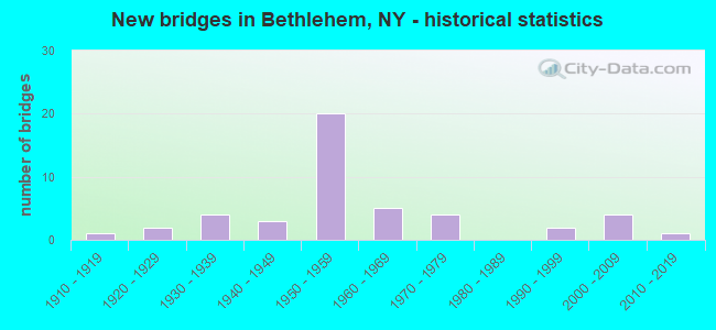
- New bridges - historical statistics
- 11910-1919
- 21920-1929
- 41930-1939
- 31940-1949
- 201950-1959
- 51960-1969
- 41970-1979
- 21990-1999
- 42000-2009
- 12010-2019
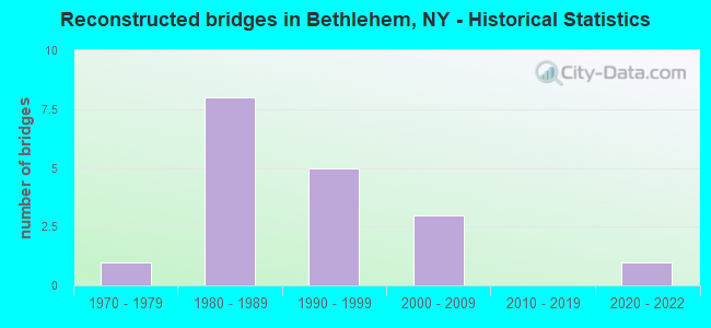
- Reconstructed bridges - Historical Statistics
- 11970-1979
- 81980-1989
- 51990-1999
- 32000-2009
- 02010-2019
- 12020-2022
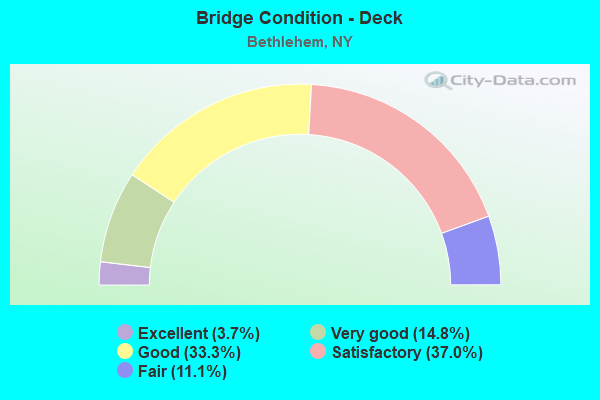
- Bridge Condition - Deck
- 3.7%Excellent
- 14.8%Very good
- 33.3%Good
- 37.0%Satisfactory
- 11.1%Fair
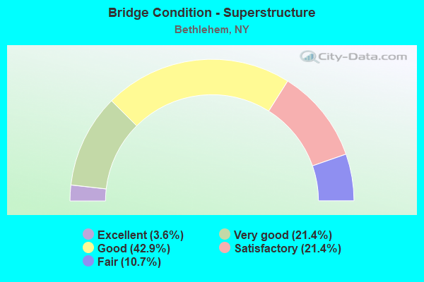
- Bridge Condition - Superstructure
- 3.6%Excellent
- 21.4%Very good
- 42.9%Good
- 21.4%Satisfactory
- 10.7%Fair
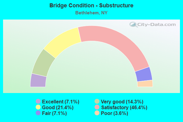
- Bridge Condition - Substructure
- 7.1%Excellent
- 14.3%Very good
- 21.4%Good
- 46.4%Satisfactory
- 7.1%Fair
- 3.6%Poor
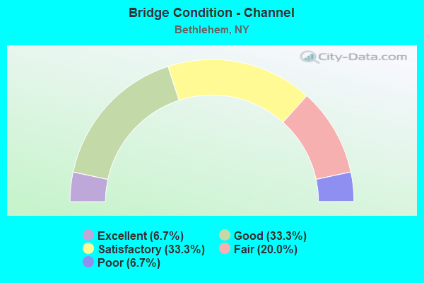
- Bridge Condition - Channel
- 6.7%Excellent
- 33.3%Good
- 33.3%Satisfactory
- 20.0%Fair
- 6.7%Poor
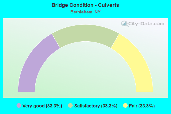
- Bridge Condition - Culverts
- 33.3%Very good
- 33.3%Satisfactory
- 33.3%Fair
Find on map >> Show street view
Structure Number: 100757, Location: 1 MI S.JCT 9W < 396 (Lat: 42.534075, Lng: -73.805819), Route carried "on" structure: US 9W, Year Built: 1976, Status: Open, Structure Length: 6.86m (22.51ft), Average Daily Traffic: 6,265 (year 2018), Truck Traffic: 9%, Average Future Daily Traffic: 6,294 (year 2040), Design Load: HS 20, Features Intersected: CSX TRANS/C P RWY
Minimum Vertical Clearance: 30+ m (98+ ft), Kilometerpoint: 8.335, Lanes on structure: 4, Base Highway Network: Yes, Owner: State Highway Agency, Approaching Roadway Width: 23.2m (76.1ft), Skew: 3 degrees, Material/Design: Prestressed concrete, Design/Construction: Box Beam or Girders - Multiple, Number Of Spans In Main Unit: 3, Length of Maximum Span: 28.9m (94.8ft), Curb-To-Curb Width: 23.2m (76.1ft), Out-to-Out Width: 24.1m (79.1ft)
Condition: Deck: Satisfactory, Superstructure: Fair, Substructure: Poor, Operating Rating: 57.2 metric tons, Method Used To Determine Operating Rating: Load Factor (LF), Inventory Rating: 34.5 metric tons, Method Used To Determine Inventory Rating: Load Factor (LF), Structural Evaluation: Meets minimum limits, Deck Geometry: Superior to present desirable criteria, Underclear: Better than present minimum criteria, Approach Roadway Alignment: Equal to present desirable criteria, Length Of Structure Improvement: 6.85m (22.47ft), Designated Inspection Frequency: Every 12 months, Inspection Date: October 2021, Bridge Improvement Cost: $4,781,000, Roadway Improvement Cost: $2,800,000, Total Project Cost: $7,581,000 ( Estimate for 2021), Wearing Surface/Protective System: Wearing Surface: Bituminous
Find on map >> Show street view
Structure Number: 100758, Location: 0.9 MI N JCT RTS 9W & 396 (Lat: 42.560164, Lng: -73.807753), Route carried "on" structure: US 9W, Year Built: 1941, Year Reconstructed: 1991, Status: Open, Structure Length: 5.03m (16.50ft), Average Daily Traffic: 7,488 (year 2018), Truck Traffic: 9%, Average Future Daily Traffic: 7,523 (year 2040), Features Intersected: VLOMAN KILL
Minimum Vertical Clearance: 30+ m (98+ ft), Kilometerpoint: 11.295, Lanes on structure: 2, Base Highway Network: Yes, Owner: State Highway Agency, Approaching Roadway Width: 9.8m (32.2ft), Skew: 3 degrees, Material/Design: Steel, Design/Construction: Stringer/Multi-beam, Number Of Spans In Main Unit: 3, Length of Maximum Span: 15.8m (51.8ft), Curb-To-Curb Width: 10.0m (32.8ft), Out-to-Out Width: 10.6m (34.8ft)
Condition: Deck: Satisfactory, Superstructure: Good, Substructure: Satisfactory, Channel: Good, Operating Rating: 74.4 metric tons, Method Used To Determine Operating Rating: Load Factor (LF), Inventory Rating: 44.5 metric tons, Method Used To Determine Inventory Rating: Load Factor (LF), Structural Evaluation: Equal to present minimum criteria, Deck Geometry: Meets minimum limits, Waterway Adequacy: Somewhat better than minimum adequacy, Approach Roadway Alignment: Equal to present desirable criteria, Length Of Structure Improvement: 5.02m (16.47ft), Designated Inspection Frequency: Every 24 months, Inspection Date: May 2020, Bridge Improvement Cost: $1,186,000, Roadway Improvement Cost: $694,000, Total Project Cost: $1,880,000 ( Estimate for 2021), Deck Structure Type: Concrete Cast-file-Place, Wearing Surface/Protective System: Wearing Surface: Bituminous, Deck Protection: Epoxy Coated Reinforcing
Find on map >> Show street view
Structure Number: 100759, Location: JCT RTS 9W & 32 (Lat: 42.616528, Lng: -73.785344), Route carried "on" structure: State highway 32, Year Built: 1963, Status: Open, Structure Length: 5.97m (19.59ft), Average Daily Traffic: 8,707 (year 2020), Truck Traffic: 6%, Average Future Daily Traffic: 10,089 (year 2040), Design Load: HS 20, Features Intersected: RTE 9W
Minimum Vertical Clearance: 30+ m (98+ ft), Kilometerpoint: 33.387, Lanes on structure: 2, Lanes under structure: 2, Base Highway Network: Yes, Owner: State Highway Agency, Approaching Roadway Width: 8.5m (27.9ft), Skew: 4 degrees, Material/Design: Steel, Design/Construction: Stringer/Multi-beam, Number Of Spans In Main Unit: 3, Length of Maximum Span: 22.5m (73.8ft), Curb-To-Curb Width: 9.1m (29.9ft), Out-to-Out Width: 10.2m (33.5ft)
Condition: Deck: Good, Superstructure: Satisfactory, Substructure: Satisfactory, Operating Rating: 61.7 metric tons, Method Used To Determine Operating Rating: Load Factor (LF), Inventory Rating: 37.2 metric tons, Method Used To Determine Inventory Rating: Load Factor (LF), Structural Evaluation: Equal to present minimum criteria, Deck Geometry: High priority of replacement, Underclear: High priority of corrective action, Approach Roadway Alignment: Equal to present desirable criteria, Length Of Structure Improvement: 5.97m (19.59ft), Designated Inspection Frequency: Every 24 months, Inspection Date: April 2021, Bridge Improvement Cost: $1,363,000, Roadway Improvement Cost: $798,000, Total Project Cost: $2,160,000 ( Estimate for 2021), Deck Structure Type: Concrete Cast-file-Place, Wearing Surface/Protective System: Wearing Surface: Integral Concrete
Find on map >> Show street view
Structure Number: 102242, Location: 2.0 MI SW JT RT 32 & 910A (Lat: 42.580439, Lng: -73.872056), Route carried "on" structure: State highway 32, Year Built: 2000, Status: Open, Structure Length: 10.64m (34.91ft), Average Daily Traffic: 7,067 (year 2020), Truck Traffic: 11%, Average Future Daily Traffic: 8,743 (year 2040), Design Load: HS 20, Features Intersected: CSX TRANSPORTATION
Minimum Vertical Clearance: 30+ m (98+ ft), Kilometerpoint: 23.781, Lanes on structure: 2, Base Highway Network: Yes, Owner: State Highway Agency, Approaching Roadway Width: 9.8m (32.2ft), Material/Design: Steel continuous, Design/Construction: Stringer/Multi-beam, Number Of Spans In Main Unit: 3, Length of Maximum Span: 40.2m (131.9ft), Curb-To-Curb Width: 9.8m (32.2ft), Out-to-Out Width: 10.5m (34.4ft)
Condition: Deck: Good, Superstructure: Good, Substructure: Very good, Operating Rating: 68.9 metric tons, Method Used To Determine Operating Rating: Load Factor (LF), Inventory Rating: 39.0 metric tons, Method Used To Determine Inventory Rating: Load Factor (LF), Structural Evaluation: Better than present minimum criteria, Deck Geometry: Meets minimum limits, Underclear: Somewhat better than minimum adequacy, Approach Roadway Alignment: Equal to present desirable criteria, Length Of Structure Improvement: 10.63m (34.88ft), Designated Inspection Frequency: Every 24 months, Inspection Date: September 2020, Bridge Improvement Cost: $2,637,000, Roadway Improvement Cost: $1,544,000, Total Project Cost: $4,181,000 ( Estimate for 2021), Deck Structure Type: Concrete Cast-file-Place, Wearing Surface/Protective System: Wearing Surface: Integral Concrete, Deck Protection: Epoxy Coated Reinforcing
Find on map >> Show street view
Structure Number: 102243, Location: 0.9 MI SW JT RT 32 & 910A (Lat: 42.588494, Lng: -73.855281), Route carried "on" structure: State highway 32, Year Built: 1937, Status: Open, Structure Length: 1.28m (4.20ft), Average Daily Traffic: 6,495 (year 2016), Truck Traffic: 10%, Average Future Daily Traffic: 7,890 (year 2040), Features Intersected: VLOMAN KILL CREEK
Minimum Vertical Clearance: 30+ m (98+ ft), Kilometerpoint: 25.519, Lanes on structure: 2, Base Highway Network: Yes, Owner: State Highway Agency, Approaching Roadway Width: 12.2m (40.0ft), Skew: 3 degrees, Material/Design: Concrete continuous, Design/Construction: Culvert, Number Of Spans In Main Unit: 2, Length of Maximum Span: 4.6m (15.1ft)
Condition: Channel: Fair, Culverts: Fair, Operating Rating: 76.2 metric tons, Method Used To Determine Operating Rating: Load Factor (LF), Inventory Rating: 45.4 metric tons, Method Used To Determine Inventory Rating: Load Factor (LF), Structural Evaluation: Somewhat better than minimum adequacy, Waterway Adequacy: Meets minimum limits, Approach Roadway Alignment: Equal to present desirable criteria, Length Of Structure Improvement: 1.28m (4.20ft), Designated Inspection Frequency: Every 24 months, Inspection Date: June 2020, Bridge Improvement Cost: $275,000, Roadway Improvement Cost: $161,000, Total Project Cost: $436,000 ( Estimate for 2021), Wearing Surface/Protective System: Wearing Surface: Bituminous
Find on map >> Show street view
Structure Number: 102244, Location: 0.5 MI E JCT RT 9W & 910A (Lat: 42.599569, Lng: -73.785094), Route carried "on" structure: State highway 910A, Year Built: 1952, Year Reconstructed: 1990, Status: Open, Structure Length: 7.16m (23.49ft), Average Daily Traffic: 4,845 (year 2018), Truck Traffic: 5%, Average Future Daily Traffic: 5,885 (year 2040), Design Load: HS 20, Features Intersected: 87IX SB, RTE 87I
Minimum Vertical Clearance: 30+ m (98+ ft), Kilometerpoint: 4.779, Lanes on structure: 2, Lanes under structure: 4, Base Highway Network: Yes, Owner: State Toll Authority, Approaching Roadway Width: 8.5m (27.9ft), Material/Design: Steel, Design/Construction: Stringer/Multi-beam, Number Of Spans In Main Unit: 4, Length of Maximum Span: 19.2m (63.0ft), Curb-To-Curb Width: 9.1m (29.9ft), Out-to-Out Width: 10.1m (33.1ft)
Condition: Deck: Good, Superstructure: Very good, Substructure: Good, Operating Rating: 89.8 metric tons, Method Used To Determine Operating Rating: Load Factor (LF), Inventory Rating: 53.5 metric tons, Method Used To Determine Inventory Rating: Load Factor (LF), Structural Evaluation: Better than present minimum criteria, Deck Geometry: Meets minimum limits, Underclear: Meets minimum limits, Approach Roadway Alignment: Equal to present desirable criteria, Length Of Structure Improvement: 7.16m (23.49ft), Designated Inspection Frequency: Every 24 months, Inspection Date: August 2021, Bridge Improvement Cost: $1,504,000, Roadway Improvement Cost: $881,000, Total Project Cost: $2,385,000 ( Estimate for 2021), Deck Structure Type: Concrete Cast-file-Place, Wearing Surface/Protective System: Wearing Surface: Integral Concrete, Deck Protection: Epoxy Coated Reinforcing
Find on map >> Show street view
Structure Number: 102245, Location: .1 MI N JCT SH 32 & SH144 (Lat: 42.620228, Lng: -73.766650), Route carried "on" structure: State highway 32, Year Built: 1996, Status: Open, Structure Length: 4.33m (14.21ft), Average Daily Traffic: 7,620 (year 2020), Truck Traffic: 17%, Average Future Daily Traffic: 9,256 (year 2040), Design Load: HS 25 or greater, Features Intersected: NORMANS KILL
Minimum Vertical Clearance: 30+ m (98+ ft), Kilometerpoint: 35.382, Lanes on structure: 2, Base Highway Network: Yes, Owner: State Highway Agency, Approaching Roadway Width: 12.2m (40.0ft), Skew: 1 degrees, Material/Design: Steel, Design/Construction: Stringer/Multi-beam, Number Of Spans In Main Unit: 1, Length of Maximum Span: 42.6m (139.8ft), Curb-To-Curb Width: 12.2m (40.0ft), Out-to-Out Width: 12.8m (42.0ft)
Condition: Deck: Very good, Superstructure: Very good, Substructure: Very good, Channel: Good, Operating Rating: 89.8 metric tons, Method Used To Determine Operating Rating: Load Factor (LF), Inventory Rating: 50.8 metric tons, Method Used To Determine Inventory Rating: Load Factor (LF), Structural Evaluation: Equal to present desirable criteria, Deck Geometry: Somewhat better than minimum adequacy, Waterway Adequacy: Equal to present minimum criteria, Approach Roadway Alignment: Equal to present desirable criteria, Length Of Structure Improvement: 4.32m (14.17ft), Designated Inspection Frequency: Every 24 months, Inspection Date: April 2021, Bridge Improvement Cost: $1,181,000, Roadway Improvement Cost: $692,000, Total Project Cost: $1,873,000 ( Estimate for 2021), Deck Structure Type: Concrete Cast-file-Place, Wearing Surface/Protective System: Wearing Surface: Integral Concrete, Deck Protection: Epoxy Coated Reinforcing
Find on map >> Show street view
Structure Number: 103266, Location: 0.4 MI NE JCT RTS 85&910E (Lat: 42.647961, Lng: -73.846006), Route carried "on" structure: Spur Other road 910E, Year Built: 2005, Status: Open, Structure Length: 5.06m (16.60ft), Average Daily Traffic: 6,683 (year 2018), Truck Traffic: 3%, Average Future Daily Traffic: 8,118 (year 2040), Design Load: HS 25 or greater, Features Intersected: NORMANS KILL
Minimum Vertical Clearance: 30+ m (98+ ft), Kilometerpoint: 1.432, Lanes on structure: 2, Base Highway Network: Yes, Owner: State Highway Agency, Approaching Roadway Width: 9.4m (30.8ft), Material/Design: Steel, Design/Construction: Stringer/Multi-beam, Number Of Spans In Main Unit: 1, Length of Maximum Span: 50.0m (164.0ft), Curb or Sidewalk Widths: Left: 0.0m, Right: 1.7m (5.6ft), Curb-To-Curb Width: 9.4m (30.8ft), Out-to-Out Width: 12.0m (39.4ft)
Condition: Deck: Good, Superstructure: Very good, Substructure: Excellent, Channel: Excellent, Operating Rating: 67.1 metric tons, Method Used To Determine Operating Rating: Load Factor (LF), Inventory Rating: 39.9 metric tons, Method Used To Determine Inventory Rating: Load Factor (LF), Structural Evaluation: Equal to present desirable criteria, Deck Geometry: High priority of corrective action, Waterway Adequacy: Equal to present desirable criteria, Approach Roadway Alignment: Equal to present desirable criteria, Length Of Structure Improvement: 5.05m (16.57ft), Designated Inspection Frequency: Every 24 months, Inspection Date: May 2021, Bridge Improvement Cost: $1,383,000, Roadway Improvement Cost: $810,000, Total Project Cost: $2,193,000 ( Estimate for 2021), Deck Structure Type: Concrete Cast-file-Place, Wearing Surface/Protective System: Wearing Surface: Integral Concrete, Deck Protection: Epoxy Coated Reinforcing
Find on map >> Show street view
Structure Number: 103812, Location: 1.6 MI N JCT RT 144 & 396 (Lat: 42.548811, Lng: -73.769856), Route carried "on" structure: State highway 144, Year Built: 1947, Year Reconstructed: 2000, Status: Open, Structure Length: 2.53m (8.30ft), Average Daily Traffic: 4,157 (year 2016), Truck Traffic: 12%, Average Future Daily Traffic: 5,143 (year 2040), Design Load: HS 25 or greater, Features Intersected: VLOMAN KILL
Minimum Vertical Clearance: 30+ m (98+ ft), Kilometerpoint: 10.249, Lanes on structure: 2, Base Highway Network: Yes, Owner: State Highway Agency, Approaching Roadway Width: 10.7m (35.1ft), Skew: 3 degrees, Material/Design: Steel, Design/Construction: Stringer/Multi-beam, Number Of Spans In Main Unit: 1, Length of Maximum Span: 22.8m (74.8ft), Curb-To-Curb Width: 10.8m (35.4ft), Out-to-Out Width: 11.8m (38.7ft)
Condition: Deck: Satisfactory, Superstructure: Good, Substructure: Fair, Channel: Satisfactory, Operating Rating: 77.1 metric tons, Method Used To Determine Operating Rating: Load Factor (LF), Inventory Rating: 45.4 metric tons, Method Used To Determine Inventory Rating: Load Factor (LF), Structural Evaluation: Somewhat better than minimum adequacy, Deck Geometry: Somewhat better than minimum adequacy, Waterway Adequacy: Equal to present desirable criteria, Approach Roadway Alignment: Equal to present desirable criteria, Length Of Structure Improvement: 2.52m (8.27ft), Designated Inspection Frequency: Every 24 months, Inspection Date: May 2020, Bridge Improvement Cost: $1,274,000, Roadway Improvement Cost: $746,000, Total Project Cost: $2,021,000 ( Estimate for 2021), Deck Structure Type: Concrete Cast-file-Place, Wearing Surface/Protective System: Wearing Surface: Monolithic Concrete, Deck Protection: Epoxy Coated Reinforcing
Find on map >> Show street view
Structure Number: 103813, Location: .5 MI SE JCT SH144 & 910A (Lat: 42.599692, Lng: -73.768150), Route carried "on" structure: State highway 144, Year Built: 1930, Year Reconstructed: 1976, Status: Open, Structure Length: 2.71m (8.89ft), Average Daily Traffic: 4,157 (year 2016), Truck Traffic: 12%, Average Future Daily Traffic: 5,049 (year 2040), Features Intersected: CSX TRANSPRTATION
Minimum Vertical Clearance: 30+ m (98+ ft), Kilometerpoint: 15.993, Lanes on structure: 2, Base Highway Network: Yes, Owner: State Highway Agency, Approaching Roadway Width: 10.4m (34.1ft), Skew: 4 degrees, Material/Design: Steel, Design/Construction: Girder and Floorbeam System, Number Of Spans In Main Unit: 1, Length of Maximum Span: 26.8m (87.9ft), Curb-To-Curb Width: 9.1m (29.9ft), Out-to-Out Width: 10.2m (33.5ft)
Condition: Deck: Fair, Superstructure: Satisfactory, Substructure: Satisfactory, Operating Rating: 44.1 metric tons, Method Used To Determine Operating Rating: Load and Resistance Factor Rating (LRFR) rating reported by rating factor(RF) method using HL-93 loadings, Inventory Rating: 34.0 metric tons, Method Used To Determine Inventory Rating: Load and Resistance Factor Rating (LRFR) rating reported by rating factor(RF) method using HL-93 loadings, Structural Evaluation: Equal to present minimum criteria, Deck Geometry: Meets minimum limits, Underclear: High priority of corrective action, Approach Roadway Alignment: Meets minimum limits, Length Of Structure Improvement: 2.71m (8.89ft), Designated Inspection Frequency: Every 24 months, Critical Feature Inspection Frequency: Every 12 months, Inspection Date: November 2020, Critical Feature Inspection Date: November 2020, Bridge Improvement Cost: $717,000, Roadway Improvement Cost: $420,000, Total Project Cost: $1,137,000 ( Estimate for 2021), Deck Structure Type: Concrete Cast-file-Place, Wearing Surface/Protective System: Wearing Surface: Bituminous
Find on map >> Show street view
Structure Number: 104748, Location: 1.4 MI SW JCT 9W < 396 (Lat: 42.538575, Lng: -73.827775), Route carried "on" structure: State highway 396, Year Built: 1977, Status: Open, Structure Length: 2.87m (9.42ft), Average Daily Traffic: 1,938 (year 2020), Truck Traffic: 21%, Average Future Daily Traffic: 2,021 (year 2040), Design Load: HS 20, Features Intersected: COEYMANS CREEK
Minimum Vertical Clearance: 30+ m (98+ ft), Kilometerpoint: 5.583, Lanes on structure: 2, Base Highway Network: Yes, Owner: State Highway Agency, Approaching Roadway Width: 11.6m (38.1ft), Material/Design: Prestressed concrete, Design/Construction: Box Beam or Girders - Multiple, Number Of Spans In Main Unit: 1, Length of Maximum Span: 27.7m (90.9ft), Curb-To-Curb Width: 11.6m (38.1ft), Out-to-Out Width: 12.6m (41.3ft)
Condition: Deck: Satisfactory, Superstructure: Fair, Substructure: Satisfactory, Channel: Satisfactory, Operating Rating: 45.4 metric tons, Method Used To Determine Operating Rating: Load Factor (LF), Inventory Rating: 27.2 metric tons, Method Used To Determine Inventory Rating: Load Factor (LF), Structural Evaluation: Somewhat better than minimum adequacy, Deck Geometry: Equal to present minimum criteria, Waterway Adequacy: Meets minimum limits, Approach Roadway Alignment: Equal to present desirable criteria, Length Of Structure Improvement: 2.86m (9.38ft), Designated Inspection Frequency: Every 24 months, Inspection Date: March 2021, Bridge Improvement Cost: $1,445,000, Roadway Improvement Cost: $846,000, Total Project Cost: $2,291,000 ( Estimate for 2021), Deck Structure Type: Concrete Cast-file-Place, Wearing Surface/Protective System: Wearing Surface: Integral Concrete
Find on map >> Show street view
Structure Number: 104749, Location: .7 MI SW JCT US9W & SH396 (Lat: 42.542522, Lng: -73.816936), Route carried "on" structure: State highway 396, Year Built: 1990, Status: Open, Structure Length: 9.51m (31.20ft), Average Daily Traffic: 1,938 (year 2020), Truck Traffic: 21%, Average Future Daily Traffic: 2,021 (year 2040), Design Load: HS 20, Features Intersected: CSX TRANSPRTATION
Minimum Vertical Clearance: 30+ m (98+ ft), Kilometerpoint: 4.505, Lanes on structure: 2, Base Highway Network: Yes, Owner: State Highway Agency, Approaching Roadway Width: 8.5m (27.9ft), Material/Design: Steel continuous, Design/Construction: Stringer/Multi-beam, Number Of Spans In Main Unit: 3, Length of Maximum Span: 39.0m (128.0ft), Curb-To-Curb Width: 8.4m (27.6ft), Out-to-Out Width: 9.3m (30.5ft)
Condition: Deck: Good, Superstructure: Satisfactory, Substructure: Very good, Operating Rating: 67.1 metric tons, Method Used To Determine Operating Rating: Load Factor (LF), Inventory Rating: 36.3 metric tons, Method Used To Determine Inventory Rating: Load Factor (LF), Structural Evaluation: Equal to present minimum criteria, Deck Geometry: Meets minimum limits, Underclear: Equal to present minimum criteria, Approach Roadway Alignment: Equal to present desirable criteria, Length Of Structure Improvement: 9.50m (31.17ft), Designated Inspection Frequency: Every 24 months, Inspection Date: October 2021, Bridge Improvement Cost: $1,901,000, Roadway Improvement Cost: $1,113,000, Total Project Cost: $3,014,000 ( Estimate for 2021), Deck Structure Type: Concrete Cast-file-Place, Wearing Surface/Protective System: Wearing Surface: Integral Concrete, Deck Protection: Epoxy Coated Reinforcing
Find on map >> Show street view
Structure Number: 104751, Location: JCT RTE 396 & I87 (Lat: 42.529839, Lng: -73.785731), Route carried "on" structure: State highway 396, Year Built: 1954, Year Reconstructed: 1985, Status: Open, Structure Length: 8.78m (28.81ft), Average Daily Traffic: 1,385 (year 2019), Truck Traffic: 27%, Average Future Daily Traffic: 1,713 (year 2040), Design Load: HS 20, Features Intersected: 87IX SB, RTE I87
Minimum Vertical Clearance: 30+ m (98+ ft), Kilometerpoint: 10.507, Lanes on structure: 2, Lanes under structure: 5, Base Highway Network: Yes, Owner: State Toll Authority, Approaching Roadway Width: 11.0m (36.1ft), Material/Design: Steel, Design/Construction: Stringer/Multi-beam, Number Of Spans In Main Unit: 4, Length of Maximum Span: 23.5m (77.1ft), Curb-To-Curb Width: 11.0m (36.1ft), Out-to-Out Width: 11.9m (39.0ft)
Condition: Deck: Fair, Superstructure: Good, Substructure: Satisfactory, Operating Rating: 75.3 metric tons, Method Used To Determine Operating Rating: Load Factor (LF), Inventory Rating: 44.5 metric tons, Method Used To Determine Inventory Rating: Load Factor (LF), Structural Evaluation: Equal to present minimum criteria, Deck Geometry: Equal to present minimum criteria, Underclear: High priority of corrective action, Approach Roadway Alignment: Equal to present desirable criteria, Length Of Structure Improvement: 8.77m (28.77ft), Designated Inspection Frequency: Every 24 months, Inspection Date: September 2020, Bridge Improvement Cost: $2,158,000, Roadway Improvement Cost: $1,264,000, Total Project Cost: $3,421,000 ( Estimate for 2021), Deck Structure Type: Concrete Cast-file-Place, Wearing Surface/Protective System: Wearing Surface: Integral Concrete, Deck Protection: Epoxy Coated Reinforcing
Find on map >> Show street view
Structure Number: 106029, Location: JCT S H 85 & NORMANS KILL (Lat: 42.648508, Lng: -73.848436), Route carried "on" structure: State highway 85, Year Built: 2001, Year Reconstructed: 2007, Status: Open, Structure Length: 5.43m (17.81ft), Average Daily Traffic: 18,509 (year 2016), Truck Traffic: 2%, Average Future Daily Traffic: 18,595 (year 2040), Design Load: HS 25 or greater, Features Intersected: NORMANS KILL
Minimum Vertical Clearance: 30+ m (98+ ft), Kilometerpoint: 36.701, Lanes on structure: 4, Base Highway Network: Yes, Owner: State Highway Agency, Approaching Roadway Width: 14.9m (48.9ft), Skew: 34 degrees, Material/Design: Steel, Design/Construction: Stringer/Multi-beam, Number Of Spans In Main Unit: 1, Length of Maximum Span: 52.1m (170.9ft), Curb or Sidewalk Widths: Left: 0.0m, Right: 3.0m (9.8ft), Curb-To-Curb Width: 17.4m (57.1ft), Out-to-Out Width: 26.3m (86.3ft)
Condition: Deck: Good, Superstructure: Very good, Substructure: Very good, Channel: Good, Operating Rating: 83.0 metric tons, Method Used To Determine Operating Rating: Load Factor (LF), Inventory Rating: 49.0 metric tons, Method Used To Determine Inventory Rating: Load Factor (LF), Structural Evaluation: Equal to present desirable criteria, Deck Geometry: Somewhat better than minimum adequacy, Waterway Adequacy: Equal to present minimum criteria, Approach Roadway Alignment: Equal to present desirable criteria, Length Of Structure Improvement: 5.42m (17.78ft), Designated Inspection Frequency: Every 24 months, Inspection Date: June 2021, Bridge Improvement Cost: $4,801,000, Roadway Improvement Cost: $2,812,000, Total Project Cost: $7,613,000 ( Estimate for 2021), Deck Structure Type: Concrete Cast-file-Place, Wearing Surface/Protective System: Wearing Surface: Integral Concrete, Deck Protection: Epoxy Coated Reinforcing
Find on map >> Show street view
Structure Number: 10603, Location: JCT.RTES 85<87I S.EXIT 24 (Lat: 42.658242, Lng: -73.823956), Route carried "on" structure: State highway 85, Year Built: 1964, Status: Open, Structure Length: 6.77m (22.21ft), Average Daily Traffic: 14,256 (year 2018), Truck Traffic: 3%, Average Future Daily Traffic: 14,323 (year 2040), Design Load: HS 20+Mod, Features Intersected: 87I NB 144.70, RTE I87
Minimum Vertical Clearance: 30+ m (98+ ft), Kilometerpoint: 39.050, Lanes on structure: 2, Lanes under structure: 6, Base Highway Network: Yes, Owner: State Highway Agency, Approaching Roadway Width: 13.4m (44.0ft), Skew: 1 degrees, Material/Design: Steel, Design/Construction: Stringer/Multi-beam, Number Of Spans In Main Unit: 4, Length of Maximum Span: 19.5m (64.0ft), Curb or Sidewalk Widths: Left: 0.4m (1.3ft), Right: 0.4m (1.3ft), Curb-To-Curb Width: 11.6m (38.1ft), Out-to-Out Width: 13.2m (43.3ft)
Condition: Deck: Fair, Superstructure: Satisfactory, Substructure: Satisfactory, Operating Rating: 80.0 metric tons, Method Used To Determine Operating Rating: Load and Resistance Factor Rating (LRFR) rating reported by rating factor(RF) method using HL-93 loadings, Inventory Rating: 61.6 metric tons, Method Used To Determine Inventory Rating: Load and Resistance Factor Rating (LRFR) rating reported by rating factor(RF) method using HL-93 loadings, Structural Evaluation: Equal to present minimum criteria, Deck Geometry: Somewhat better than minimum adequacy, Underclear: Meets minimum limits, Approach Roadway Alignment: Equal to present desirable criteria, Length Of Structure Improvement: 6.76m (22.18ft), Designated Inspection Frequency: Every 24 months, Inspection Date: September 2020, Bridge Improvement Cost: $1,918,000, Roadway Improvement Cost: $1,123,000, Total Project Cost: $3,042,000 ( Estimate for 2021), Deck Structure Type: Concrete Cast-file-Place, Wearing Surface/Protective System: Wearing Surface: Monolithic Concrete
Find on map >> Show street view
Structure Number: 1095909, Location: .6 MI SE JCT SH85 & SH140 (Lat: 42.627294, Lng: -73.854161), Route carried "on" structure: State highway 140, Year Built: 1969, Year Reconstructed: 2020, Status: Open, Structure Length: 4.63m (15.19ft), Average Daily Traffic: 14,532 (year 2020), Truck Traffic: 4%, Average Future Daily Traffic: 17,653 (year 2040), Features Intersected: ALBANY CO. RAIL TRAIL
Minimum Vertical Clearance: 30+ m (98+ ft), Kilometerpoint: 1.995, Lanes on structure: 4, Base Highway Network: Yes, Owner: State Highway Agency, Approaching Roadway Width: 21.9m (71.9ft), Skew: 20 degrees, Material/Design: Steel, Design/Construction: Stringer/Multi-beam, Number Of Spans In Main Unit: 3, Length of Maximum Span: 14.9m (48.9ft), Curb-To-Curb Width: 26.8m (87.9ft), Out-to-Out Width: 27.7m (90.9ft)
Condition: Deck: Satisfactory, Superstructure: Good, Substructure: Good, Operating Rating: 71.7 metric tons, Method Used To Determine Operating Rating: Load Factor (LF), Inventory Rating: 42.6 metric tons, Method Used To Determine Inventory Rating: Load Factor (LF), Structural Evaluation: Better than present minimum criteria, Deck Geometry: Superior to present desirable criteria, Approach Roadway Alignment: Equal to present desirable criteria, Length Of Structure Improvement: 4.63m (15.19ft), Designated Inspection Frequency: Every 24 months, Inspection Date: July 2021, Bridge Improvement Cost: $2,809,000, Roadway Improvement Cost: $1,645,000, Total Project Cost: $4,454,000 ( Estimate for 2021), Deck Structure Type: Concrete Cast-file-Place, Wearing Surface/Protective System: Wearing Surface: Epoxy Overlay
Find on map >> Show street view
Structure Number: 220021, Location: 1 MI SW OF SELKIRK (Lat: 42.527472, Lng: -73.819939), Route carried "on" structure: Other road , Year Built: 2014, Status: Open, Structure Length: 2.56m (8.40ft), Average Daily Traffic: 422 (year 2020), Truck Traffic: 6%, Average Future Daily Traffic: 591 (year 2040), Design Load: HL 93, Features Intersected: COEYMANS CREEK, Facility Carried by Structure: PICTUAY ROAD
Minimum Vertical Clearance: 30+ m (98+ ft), Kilometerpoint: 1.384, Lanes on structure: 2, Owner: County Highway Agency, Approaching Roadway Width: 8.7m (28.5ft), Material/Design: Prestressed concrete, Design/Construction: Box Beam or Girders - Multiple, Number Of Spans In Main Unit: 1, Length of Maximum Span: 24.4m (80.1ft), Curb-To-Curb Width: 8.7m (28.5ft), Out-to-Out Width: 10.1m (33.1ft)
Condition: Deck: Excellent, Superstructure: Excellent, Substructure: Excellent, Channel: Fair, Operating Rating: 70.6 metric tons, Method Used To Determine Operating Rating: Load and Resistance Factor Rating (LRFR) rating reported by rating factor(RF) method using HL-93 loadings, Inventory Rating: 54.4 metric tons, Method Used To Determine Inventory Rating: Load and Resistance Factor Rating (LRFR) rating reported by rating factor(RF) method using HL-93 loadings, Structural Evaluation: Superior to present desirable criteria, Deck Geometry: Somewhat better than minimum adequacy, Waterway Adequacy: Somewhat better than minimum adequacy, Approach Roadway Alignment: Meets minimum limits, Length Of Structure Improvement: 2.56m (8.40ft), Designated Inspection Frequency: Every 24 months, Inspection Date: March 2021, Bridge Improvement Cost: $876,000, Roadway Improvement Cost: $513,000, Total Project Cost: $1,388,000 ( Estimate for 2021), Deck Structure Type: Concrete Cast-file-Place, Wearing Surface/Protective System: Wearing Surface: Integral Concrete, Deck Protection: Epoxy Coated Reinforcing
Find on map >> Show street view
Structure Number: 330101, Location: 2.4 MILES NW OF SELKIRK (Lat: 42.567486, Lng: -73.814164), Route carried "on" structure: County highway , Year Built: 2004, Status: Open, Structure Length: 1.37m (4.49ft), Average Daily Traffic: 297 (year 2020), Truck Traffic: 9%, Average Future Daily Traffic: 367 (year 2040), Features Intersected: DOWERS KILL, Facility Carried by Structure: COUNTY ROAD 53
Minimum Vertical Clearance: 30+ m (98+ ft), Kilometerpoint: 1.335, Lanes on structure: 2, Owner: County Highway Agency, Approaching Roadway Width: 6.1m (20.0ft), Skew: 4 degrees, Material/Design: Concrete, Design/Construction: Frame, Number Of Spans In Main Unit: 1, Length of Maximum Span: 12.2m (40.0ft), Curb-To-Curb Width: 7.2m (23.6ft), Out-to-Out Width: 8.2m (26.9ft)
Condition: Deck: Very good, Superstructure: Very good, Substructure: Good, Channel: Satisfactory, Operating Rating: 74.4 metric tons, Method Used To Determine Operating Rating: Load Factor (LF), Inventory Rating: 43.5 metric tons, Method Used To Determine Inventory Rating: Load Factor (LF), Structural Evaluation: Better than present minimum criteria, Deck Geometry: Meets minimum limits, Waterway Adequacy: Somewhat better than minimum adequacy, Approach Roadway Alignment: Equal to present desirable criteria, Length Of Structure Improvement: 1.37m (4.49ft), Designated Inspection Frequency: Every 24 months, Inspection Date: May 2021, Bridge Improvement Cost: $360,000, Roadway Improvement Cost: $211,000, Total Project Cost: $571,000 ( Estimate for 2021), Wearing Surface/Protective System: Wearing Surface: Bituminous
Find on map >> Show street view
Structure Number: 330102, Location: .1MI N OF SOUTH BETHLEHEM (Lat: 42.535525, Lng: -73.840319), Route carried "on" structure: County highway , Year Built: 1949, Year Reconstructed: 1991, Status: Open, Structure Length: 3.11m (10.20ft), Average Daily Traffic: 781 (year 2017), Truck Traffic: 11%, Average Future Daily Traffic: 1,093 (year 2037), Design Load: HS 25 or greater, Features Intersected: ONESQUETHAW CRK, Facility Carried by Structure: SO.ALBANY RD CR53
Minimum Vertical Clearance: 30+ m (98+ ft), Kilometerpoint: 0.306, Lanes on structure: 2, Owner: County Highway Agency, Approaching Roadway Width: 7.3m (24.0ft), Skew: 4 degrees, Material/Design: Prestressed concrete continuous, Design/Construction: Box Beam or Girders - Multiple, Number Of Spans In Main Unit: 2, Length of Maximum Span: 14.9m (48.9ft), Curb-To-Curb Width: 9.1m (29.9ft), Out-to-Out Width: 9.8m (32.2ft)
Condition: Deck: Satisfactory, Superstructure: Fair, Substructure: Fair, Channel: Fair, Operating Rating: 56.1 metric tons, Method Used To Determine Operating Rating: Load and Resistance Factor Rating (LRFR) rating reported by rating factor(RF) method using HL-93 loadings, Inventory Rating: 35.6 metric tons, Method Used To Determine Inventory Rating: Load and Resistance Factor Rating (LRFR) rating reported by rating factor(RF) method using HL-93 loadings, Structural Evaluation: Somewhat better than minimum adequacy, Deck Geometry: Equal to present minimum criteria, Waterway Adequacy: Superior to present desirable criteria, Approach Roadway Alignment: Equal to present minimum criteria, Length Of Structure Improvement: 3.10m (10.17ft), Designated Inspection Frequency: Every 24 months, Inspection Date: April 2020, Bridge Improvement Cost: $1,232,000, Roadway Improvement Cost: $722,000, Total Project Cost: $1,954,000 ( Estimate for 2021), Deck Structure Type: Concrete Cast-file-Place, Wearing Surface/Protective System: Wearing Surface: Integral Concrete, Deck Protection: Epoxy Coated Reinforcing
Find on map >> Show street view
Structure Number: 330104, Location: 1.1 MI W OF SO BETHLEHEM (Lat: 42.537442, Lng: -73.868431), Route carried "on" structure: County highway , Year Built: 1934, Year Reconstructed: 1992, Status: Open, Structure Length: 2.41m (7.91ft), Average Daily Traffic: 1,039 (year 2017), Truck Traffic: 6%, Average Future Daily Traffic: 1,455 (year 2037), Features Intersected: ONESQUETHAW CREEK, Facility Carried by Structure: COUNTY ROAD 102
Minimum Vertical Clearance: 30+ m (98+ ft), Kilometerpoint: 8.544, Lanes on structure: 2, Owner: County Highway Agency, Approaching Roadway Width: 6.1m (20.0ft), Skew: 1 degrees, Material/Design: Concrete, Design/Construction: Arch - Deck, Number Of Spans In Main Unit: 1, Length of Maximum Span: 20.1m (65.9ft), Curb-To-Curb Width: 7.3m (24.0ft), Out-to-Out Width: 9.1m (29.9ft)
Condition: Superstructure: Satisfactory, Substructure: Satisfactory, Channel: Good, Operating Rating: 58.7 metric tons, Method Used To Determine Operating Rating: Field evaluation and documented engineering judgment, Inventory Rating: 23.0 metric tons, Method Used To Determine Inventory Rating: Field evaluation and documented engineering judgment, Structural Evaluation: Equal to present minimum criteria, Deck Geometry: Meets minimum limits, Waterway Adequacy: Equal to present minimum criteria, Approach Roadway Alignment: Better than present minimum criteria, Length Of Structure Improvement: 2.40m (7.87ft), Designated Inspection Frequency: Every 24 months, Inspection Date: March 2021, Bridge Improvement Cost: $945,000, Roadway Improvement Cost: $553,000, Total Project Cost: $1,498,000 ( Estimate for 2021)
Find on map >> Show street view
Structure Number: 330105, Location: 1.8 MI N OF SELKIRK (Lat: 42.558808, Lng: -73.809658), Route carried "on" structure: County highway , Year Built: 1976, Status: Open, Structure Length: 1.58m (5.18ft), Average Daily Traffic: 2,208 (year 2020), Truck Traffic: 23%, Average Future Daily Traffic: 2,731 (year 2040), Features Intersected: VLOMAN KILL, Facility Carried by Structure: COUNTY ROAD 55
Minimum Vertical Clearance: 30+ m (98+ ft), Kilometerpoint: 5.792, Lanes on structure: 2, Owner: County Highway Agency, Approaching Roadway Width: 9.8m (32.2ft), Material/Design: Steel, Design/Construction: Culvert, Number Of Spans In Main Unit: 3, Length of Maximum Span: 3.7m (12.1ft)
Condition: Channel: Satisfactory, Culverts: Very good, Operating Rating: 75.1 metric tons, Method Used To Determine Operating Rating: Field evaluation and documented engineering judgment, Inventory Rating: 32.7 metric tons, Method Used To Determine Inventory Rating: Field evaluation and documented engineering judgment, Structural Evaluation: Equal to present desirable criteria, Waterway Adequacy: Somewhat better than minimum adequacy, Approach Roadway Alignment: Equal to present desirable criteria, Length Of Structure Improvement: 1.58m (5.18ft), Designated Inspection Frequency: Every 24 months, Inspection Date: May 2021, Bridge Improvement Cost: $295,000, Roadway Improvement Cost: $173,000, Total Project Cost: $468,000 ( Estimate for 2021)
Find on map >> Show street view
Structure Number: 336361, Location: 2.2 MI N OF SO BETHLEHEM (Lat: 42.565431, Lng: -73.829975), Route carried "on" structure: County highway , Year Built: 1976, Status: Open, Structure Length: 1.68m (5.51ft), Average Daily Traffic: 2,208 (year 2020), Truck Traffic: 23%, Average Future Daily Traffic: 2,731 (year 2040), Features Intersected: VLOMAN KILL, Facility Carried by Structure: COUNTY ROAD 55
Minimum Vertical Clearance: 30+ m (98+ ft), Kilometerpoint: 3.974, Lanes on structure: 2, Owner: County Highway Agency, Approaching Roadway Width: 10.1m (33.1ft), Skew: 3 degrees, Material/Design: Steel, Design/Construction: Culvert, Number Of Spans In Main Unit: 3, Length of Maximum Span: 4.5m (14.8ft)
Condition: Channel: Poor, Culverts: Satisfactory, Operating Rating: 75.8 metric tons, Method Used To Determine Operating Rating: Field evaluation and documented engineering judgment, Inventory Rating: 32.7 metric tons, Method Used To Determine Inventory Rating: Field evaluation and documented engineering judgment, Structural Evaluation: Equal to present minimum criteria, Waterway Adequacy: Meets minimum limits, Approach Roadway Alignment: Equal to present desirable criteria, Length Of Structure Improvement: 1.67m (5.48ft), Designated Inspection Frequency: Every 24 months, Underwater Inspection Frequency: Every 60 months, Inspection Date: September 2021, Underwater Inspection Date: July 2017, Bridge Improvement Cost: $322,000, Roadway Improvement Cost: $189,000, Total Project Cost: $510,000 ( Estimate for 2021)
Find on map >> Show street view
Structure Number: 5053419, Location: EXIT 24 THRUWAY & RTE 9W (Lat: 42.620156, Lng: -73.780497), Route carried "on" structure: Interstate 87, Year Built: 1952, Year Reconstructed: 2014, Status: Open, Structure Length: 6.25m (20.51ft), Average Daily Traffic: 37,550 (year 2020), Truck Traffic: 25%, Average Future Daily Traffic: 59,505 (year 2040), Design Load: HS 20, Features Intersected: RTE 9W
Minimum Vertical Clearance: 30+ m (98+ ft), Kilometerpoint: 18.198, Lanes on structure: 4, Lanes under structure: 4, Base Highway Network: Yes, Toll: On Interstate toll segment, Owner: State Toll Authority, Approaching Roadway Width: 35.4m (116.1ft), Skew: 23 degrees, Material/Design: Steel, Design/Construction: Stringer/Multi-beam, Number Of Spans In Main Unit: 3, Length of Maximum Span: 28.0m (91.9ft), Curb-To-Curb Width: 33.8m (110.9ft), Out-to-Out Width: 34.4m (112.9ft)
Condition: Deck: Satisfactory, Superstructure: Good, Substructure: Satisfactory, Operating Rating: 43.7 metric tons, Method Used To Determine Operating Rating: Load and Resistance Factor Rating (LRFR) rating reported by rating factor(RF) method using HL-93 loadings, Inventory Rating: 33.7 metric tons, Method Used To Determine Inventory Rating: Load and Resistance Factor Rating (LRFR) rating reported by rating factor(RF) method using HL-93 loadings, Structural Evaluation: Equal to present minimum criteria, Deck Geometry: Superior to present desirable criteria, Underclear: Meets minimum limits, Approach Roadway Alignment: Equal to present desirable criteria, Length Of Structure Improvement: 6.24m (20.47ft), Designated Inspection Frequency: Every 24 months, Inspection Date: June 2020, Bridge Improvement Cost: $4,793,000, Roadway Improvement Cost: $2,807,000, Total Project Cost: $7,599,000 ( Estimate for 2021), Deck Structure Type: Concrete Cast-file-Place, Wearing Surface/Protective System: Wearing Surface: Monolithic Concrete, Deck Protection: Epoxy Coated Reinforcing
Find on map >> Show street view
Structure Number: 5513491, Location: Exit 22 of 87IX (Lat: 42.534250, Lng: -73.783925), Route carried "on" structure: Interstate 87, Year Built: 1954, Year Reconstructed: 1994, Status: Open, Structure Length: 1.62m (5.31ft), Average Daily Traffic: 18,775 (year 2020), Truck Traffic: 25%, Average Future Daily Traffic: 29,752 (year 2040), Design Load: HS 25 or greater, Features Intersected: RAMP INT 22
Minimum Vertical Clearance: 30+ m (98+ ft), Kilometerpoint: 8.512, Lanes on structure: 2, Lanes under structure: 2, Base Highway Network: Yes, Toll: On Interstate toll segment, Owner: State Toll Authority, Approaching Roadway Width: 16.8m (55.1ft), Material/Design: Steel, Design/Construction: Stringer/Multi-beam, Number Of Spans In Main Unit: 1, Length of Maximum Span: 14.6m (47.9ft), Curb-To-Curb Width: 16.6m (54.5ft), Out-to-Out Width: 17.2m (56.4ft)
Condition: Deck: Satisfactory, Superstructure: Good, Substructure: Satisfactory, Operating Rating: 89.8 metric tons, Method Used To Determine Operating Rating: Load Factor (LF), Inventory Rating: 69.9 metric tons, Method Used To Determine Inventory Rating: Load Factor (LF), Structural Evaluation: Equal to present minimum criteria, Deck Geometry: Superior to present desirable criteria, Underclear: Meets minimum limits, Approach Roadway Alignment: Equal to present desirable criteria, Length Of Structure Improvement: 1.61m (5.28ft), Designated Inspection Frequency: Every 24 months, Inspection Date: July 2020, Bridge Improvement Cost: $1,333,000, Roadway Improvement Cost: $780,000, Total Project Cost: $2,113,000 ( Estimate for 2021), Deck Structure Type: Concrete Cast-file-Place, Wearing Surface/Protective System: Wearing Surface: Bituminous, Membrane: Other, Deck Protection: Epoxy Coated Reinforcing
Find on map >> Show street view
Structure Number: 5513492, Location: EXIT 22 OF I90 (Lat: 42.534303, Lng: -73.784244), Route carried "on" structure: Interstate 87, Year Built: 1954, Year Reconstructed: 1994, Status: Open, Structure Length: 1.62m (5.31ft), Average Daily Traffic: 23,062 (year 2014), Truck Traffic: 9%, Design Load: HS 25 or greater, Features Intersected: RAMP INT 22
Minimum Vertical Clearance: 30+ m (98+ ft), Kilometerpoint: 217.102, Lanes on structure: 3, Lanes under structure: 2, Base Highway Network: Yes, Toll: On Interstate toll segment, Owner: State Toll Authority, Approaching Roadway Width: 21.6m (70.9ft), Material/Design: Steel, Design/Construction: Stringer/Multi-beam, Number Of Spans In Main Unit: 1, Length of Maximum Span: 14.6m (47.9ft), Curb-To-Curb Width: 20.0m (65.6ft), Out-to-Out Width: 20.9m (68.6ft)
Condition: Deck: Good, Superstructure: Good, Substructure: Satisfactory, Operating Rating: 89.8 metric tons, Method Used To Determine Operating Rating: Load Factor (LF), Inventory Rating: 70.8 metric tons, Method Used To Determine Inventory Rating: Load Factor (LF), Structural Evaluation: Equal to present minimum criteria, Deck Geometry: Superior to present desirable criteria, Underclear: Meets minimum limits, Approach Roadway Alignment: Equal to present desirable criteria, Length Of Structure Improvement: 1.61m (5.28ft), Designated Inspection Frequency: Every 24 months, Inspection Date: July 2020, Bridge Improvement Cost: $1,615,000, Roadway Improvement Cost: $946,000, Total Project Cost: $2,561,000 ( Estimate for 2021), Deck Structure Type: Concrete Cast-file-Place, Wearing Surface/Protective System: Wearing Surface: Bituminous, Membrane: Other, Deck Protection: Epoxy Coated Reinforcing
Find on map >> Show street view
Structure Number: 55135, Location: .49 MI NW INT 22 ON I87 (Lat: 42.541275, Lng: -73.782708), Route carried "on" structure: Other road , Year Built: 1954, Year Reconstructed: 1987, Status: Open, Structure Length: 7.53m (24.70ft), Average Daily Traffic: 1,207 (year 2017), Truck Traffic: 4%, Average Future Daily Traffic: 1,690 (year 2037), Design Load: HS 20+Mod, Features Intersected: 87IX SB, RTE I87, Facility Carried by Structure: BEAVER DAM ROAD
Minimum Vertical Clearance: 30+ m (98+ ft), Kilometerpoint: 1.915, Lanes on structure: 2, Lanes under structure: 4, Owner: State Toll Authority, Approaching Roadway Width: 6.4m (21.0ft), Skew: 2 degrees, Material/Design: Steel, Design/Construction: Stringer/Multi-beam, Number Of Spans In Main Unit: 4, Length of Maximum Span: 23.5m (77.1ft), Curb-To-Curb Width: 9.4m (30.8ft), Out-to-Out Width: 10.1m (33.1ft)
Condition: Deck: Good, Superstructure: Good, Substructure: Satisfactory, Operating Rating: 72.6 metric tons, Method Used To Determine Operating Rating: Load Factor (LF), Inventory Rating: 43.5 metric tons, Method Used To Determine Inventory Rating: Load Factor (LF), Structural Evaluation: Equal to present minimum criteria, Deck Geometry: Somewhat better than minimum adequacy, Underclear: High priority of corrective action, Approach Roadway Alignment: Equal to present desirable criteria, Length Of Structure Improvement: 7.52m (24.67ft), Designated Inspection Frequency: Every 24 months, Inspection Date: May 2021, Bridge Improvement Cost: $1,604,000, Roadway Improvement Cost: $939,000, Total Project Cost: $2,544,000 ( Estimate for 2021), Deck Structure Type: Concrete Cast-file-Place, Wearing Surface/Protective System: Wearing Surface: Integral Concrete, Deck Protection: Epoxy Coated Reinforcing
Find on map >> Show street view
Structure Number: 5513511, Location: 1.2 MI NW INT22 ON I87 (Lat: 42.551192, Lng: -73.782336), Route carried "on" structure: Interstate 87, Year Built: 1954, Year Reconstructed: 1999, Status: Open, Structure Length: 13.93m (45.70ft), Average Daily Traffic: 18,775 (year 2020), Truck Traffic: 25%, Average Future Daily Traffic: 29,752 (year 2040), Design Load: HS 25 or greater, Features Intersected: CSX TRANSPRTATION, VLOMA
Minimum Vertical Clearance: 30+ m (98+ ft), Kilometerpoint: 10.362, Lanes on structure: 2, Base Highway Network: Yes, Toll: On Interstate toll segment, Owner: State Toll Authority, Approaching Roadway Width: 17.1m (56.1ft), Material/Design: Steel continuous, Design/Construction: Stringer/Multi-beam, Number Of Spans In Main Unit: 5, Length of Maximum Span: 31.1m (102.0ft), Curb-To-Curb Width: 17.0m (55.8ft), Out-to-Out Width: 17.3m (56.8ft)
Condition: Deck: Satisfactory, Superstructure: Good, Substructure: Satisfactory, Channel: Satisfactory, Operating Rating: 58.1 metric tons, Method Used To Determine Operating Rating: Load Factor (LF), Inventory Rating: 34.5 metric tons, Method Used To Determine Inventory Rating: Load Factor (LF), Structural Evaluation: Equal to present minimum criteria, Deck Geometry: Superior to present desirable criteria, Underclear: Somewhat better than minimum adequacy, Waterway Adequacy: Superior to present desirable criteria, Approach Roadway Alignment: Equal to present desirable criteria, Length Of Structure Improvement: 13.92m (45.67ft), Designated Inspection Frequency: Every 24 months, Inspection Date: May 2021, Bridge Improvement Cost: $4,997,000, Roadway Improvement Cost: $2,926,000, Total Project Cost: $7,923,000 ( Estimate for 2021), Deck Structure Type: Concrete Cast-file-Place, Wearing Surface/Protective System: Wearing Surface: Monolithic Concrete
Find on map >> Show street view
Structure Number: 5513512, Location: 1.2 MI NW INT 22 ON I87 (Lat: 42.551486, Lng: -73.782708), Route carried "on" structure: Interstate 87, Year Built: 1954, Year Reconstructed: 1999, Status: Open, Structure Length: 12.50m (41.01ft), Average Daily Traffic: 23,062 (year 2014), Truck Traffic: 9%, Design Load: HS 25 or greater, Features Intersected: CSX TRANSPRTATION, VLOMA
Minimum Vertical Clearance: 30+ m (98+ ft), Kilometerpoint: 219.033, Lanes on structure: 2, Base Highway Network: Yes, Toll: On Interstate toll segment, Owner: State Toll Authority, Approaching Roadway Width: 16.5m (54.1ft), Material/Design: Steel continuous, Design/Construction: Stringer/Multi-beam, Number Of Spans In Main Unit: 4, Length of Maximum Span: 36.6m (120.1ft), Curb-To-Curb Width: 16.6m (54.5ft), Out-to-Out Width: 17.3m (56.8ft)
Condition: Deck: Satisfactory, Superstructure: Good, Substructure: Good, Channel: Good, Operating Rating: 41.1 metric tons, Method Used To Determine Operating Rating: Load and Resistance Factor Rating (LRFR) rating reported by rating factor(RF) method using HL-93 loadings, Inventory Rating: 31.8 metric tons, Method Used To Determine Inventory Rating: Load and Resistance Factor Rating (LRFR) rating reported by rating factor(RF) method using HL-93 loadings, Structural Evaluation: Better than present minimum criteria, Deck Geometry: Superior to present desirable criteria, Underclear: Somewhat better than minimum adequacy, Waterway Adequacy: Equal to present desirable criteria, Approach Roadway Alignment: Equal to present desirable criteria, Length Of Structure Improvement: 12.49m (40.98ft), Designated Inspection Frequency: Every 24 months, Inspection Date: May 2021, Bridge Improvement Cost: $4,565,000, Roadway Improvement Cost: $2,673,000, Total Project Cost: $7,238,000 ( Estimate for 2021), Deck Structure Type: Concrete Cast-file-Place, Wearing Surface/Protective System: Wearing Surface: Monolithic Concrete
Find on map >> Show street view
Structure Number: 551352, Location: 1.8 MI NW EXIT 22 OF I90 (Lat: 42.558858, Lng: -73.787006), Route carried "on" structure: Other road , Year Built: 1954, Year Reconstructed: 1990, Status: Open, Structure Length: 6.34m (20.80ft), Average Daily Traffic: 348 (year 2020), Truck Traffic: 5%, Average Future Daily Traffic: 487 (year 2040), Design Load: HS 20+Mod, Features Intersected: 87IX SB, RTE I87, Facility Carried by Structure: CLAPPER RD
Minimum Vertical Clearance: 30+ m (98+ ft), Kilometerpoint: 1.915, Lanes on structure: 2, Lanes under structure: 4, Owner: State Toll Authority, Approaching Roadway Width: 6.4m (21.0ft), Material/Design: Steel, Design/Construction: Stringer/Multi-beam, Number Of Spans In Main Unit: 4, Length of Maximum Span: 19.2m (63.0ft), Curb-To-Curb Width: 9.5m (31.2ft), Out-to-Out Width: 10.1m (33.1ft)
Condition: Deck: Very good, Superstructure: Good, Substructure: Good, Operating Rating: 64.4 metric tons, Method Used To Determine Operating Rating: Load Factor (LF), Inventory Rating: 42.6 metric tons, Method Used To Determine Inventory Rating: Load Factor (LF), Structural Evaluation: Better than present minimum criteria, Deck Geometry: Equal to present minimum criteria, Underclear: Meets minimum limits, Approach Roadway Alignment: Equal to present minimum criteria, Length Of Structure Improvement: 6.33m (20.77ft), Designated Inspection Frequency: Every 24 months, Inspection Date: August 2020, Bridge Improvement Cost: $1,358,000, Roadway Improvement Cost: $795,000, Total Project Cost: $2,153,000 ( Estimate for 2021), Deck Structure Type: Other, Wearing Surface/Protective System: Wearing Surface: Bituminous, Membrane: Preformed Fabric
Find on map >> Show street view
Structure Number: 551353, Location: 3.11MI NW INT22 ON I87 (Lat: 42.578003, Lng: -73.788003), Route carried "on" structure: Other road , Year Built: 1954, Year Reconstructed: 1990, Status: Open, Structure Length: 6.80m (22.31ft), Average Daily Traffic: 956 (year 2018), Truck Traffic: 7%, Average Future Daily Traffic: 1,182 (year 2040), Design Load: HS 20+Mod, Features Intersected: 87IX SB, RTE 87I, Facility Carried by Structure: WEMPLE ROAD
Minimum Vertical Clearance: 30+ m (98+ ft), Kilometerpoint: 1.963, Lanes on structure: 2, Lanes under structure: 4, Owner: State Toll Authority, Approaching Roadway Width: 6.4m (21.0ft), Skew: 2 degrees, Material/Design: Steel, Design/Construction: Stringer/Multi-beam, Number Of Spans In Main Unit: 4, Length of Maximum Span: 20.7m (67.9ft), Curb-To-Curb Width: 9.3m (30.5ft), Out-to-Out Width: 10.1m (33.1ft)
Condition: Deck: Very good, Superstructure: Very good, Substructure: Good, Operating Rating: 81.3 metric tons, Method Used To Determine Operating Rating: Field evaluation and documented engineering judgment, Inventory Rating: 32.7 metric tons, Method Used To Determine Inventory Rating: Field evaluation and documented engineering judgment, Structural Evaluation: Better than present minimum criteria, Deck Geometry: Equal to present minimum criteria, Underclear: High priority of corrective action, Approach Roadway Alignment: Equal to present minimum criteria, Length Of Structure Improvement: 6.79m (22.28ft), Designated Inspection Frequency: Every 24 months, Inspection Date: April 2021, Bridge Improvement Cost: $1,454,000, Roadway Improvement Cost: $852,000, Total Project Cost: $2,306,000 ( Estimate for 2021), Deck Structure Type: Concrete Cast-file-Place, Wearing Surface/Protective System: Wearing Surface: Bituminous, Membrane: Other, Deck Protection: Epoxy Coated Reinforcing
Find on map >> Show street view
Structure Number: 55136, Location: 3.46MI NW INT 23 ON I87 (Lat: 42.665483, Lng: -73.832822), Route carried "on" structure: County highway , Year Built: 1954, Year Reconstructed: 1987, Status: Open, Structure Length: 7.44m (24.41ft), Average Daily Traffic: 1,341 (year 2019), Truck Traffic: 4%, Average Future Daily Traffic: 1,659 (year 2040), Design Load: HS 20+Mod, Features Intersected: 87IX SB, RTE I87, Facility Carried by Structure: RUSSELL ROAD
Minimum Vertical Clearance: 30+ m (98+ ft), Kilometerpoint: 0.547, Lanes on structure: 2, Lanes under structure: 6, Owner: State Toll Authority, Approaching Roadway Width: 8.8m (28.9ft), Skew: 1 degrees, Material/Design: Steel, Design/Construction: Stringer/Multi-beam, Number Of Spans In Main Unit: 4, Length of Maximum Span: 20.1m (65.9ft), Curb-To-Curb Width: 8.8m (28.9ft), Out-to-Out Width: 9.4m (30.8ft)
Condition: Deck: Good, Superstructure: Satisfactory, Substructure: Satisfactory, Operating Rating: 55.3 metric tons, Method Used To Determine Operating Rating: Load Factor (LF), Inventory Rating: 34.5 metric tons, Method Used To Determine Inventory Rating: Load Factor (LF), Structural Evaluation: Equal to present minimum criteria, Deck Geometry: Somewhat better than minimum adequacy, Underclear: High priority of corrective action, Approach Roadway Alignment: Better than present minimum criteria, Length Of Structure Improvement: 7.43m (24.38ft), Designated Inspection Frequency: Every 24 months, Inspection Date: April 2021, Bridge Improvement Cost: $1,479,000, Roadway Improvement Cost: $866,000, Total Project Cost: $2,344,000 ( Estimate for 2021), Deck Structure Type: Other, Wearing Surface/Protective System: Wearing Surface: Integral Concrete
Find on map >> Show street view
Structure Number: 100759, Location: JCT RTS 9W & 32 (Lat: 42.616528, Lng: -73.785344), Route carried "under" structure: US 9W, Year Built: 1963, Structure Length: 0. m, Average Daily Traffic: 26,008 (year 1999), Features Intersected: RTE 9W, Facility Carried by Structure: RTE 32
Minimum Vertical Clearance: 4.93m (16.17ft), Kilometerpoint: 18.375, Lanes on structure: 2, Lanes under structure: 2, Material/Design: Steel, Design/Construction: Stringer/Multi-beam, Length of Maximum Span: 22.5m (73.8ft)
Find on map >> Show street view
Structure Number: 102244, Location: 0.5 MI E JCT RT 9W & 910A (Lat: 42.599569, Lng: -73.785094), Route carried "under" structure: Interstate 87, Year Built: 1952, Structure Length: 0. m, Average Daily Traffic: 20,432 (year 1988), Features Intersected: 87IX SB, RTE 87I, Facility Carried by Structure: RTE 910A
Minimum Vertical Clearance: 4.55m (14.93ft), Kilometerpoint: 224.520, Lanes on structure: 2, Lanes under structure: 2, Toll: On Interstate toll segment, Material/Design: Steel, Design/Construction: Stringer/Multi-beam, Length of Maximum Span: 19.2m (63.0ft)
Find on map >> Show street view
Structure Number: 104751, Location: JCT RTE 396 & I87 (Lat: 42.529839, Lng: -73.785731), Route carried "under" structure: Interstate 87, Year Built: 1954, Structure Length: 0. m, Average Daily Traffic: 46,124 (year 2014), Features Intersected: 87IX SB, RTE I87, Facility Carried by Structure: RTE 396
Minimum Vertical Clearance: 4.83m (15.85ft), Kilometerpoint: 216.587, Lanes on structure: 2, Lanes under structure: 2, Toll: On Interstate toll segment, Material/Design: Steel, Design/Construction: Stringer/Multi-beam, Length of Maximum Span: 23.5m (77.1ft)
Find on map >> Show street view
Structure Number: 10603, Location: JCT.RTES 85<87I S.EXIT 24 (Lat: 42.658242, Lng: -73.823956), Route carried "under" structure: Interstate 87, Year Built: 1964, Structure Length: 0. m, Average Daily Traffic: 10,860 (year 1980), Features Intersected: 87I NB 144.70, RTE I87, Facility Carried by Structure: RTE 85
Minimum Vertical Clearance: 5.46m (17.91ft), Kilometerpoint: 232.822, Lanes on structure: 2, Lanes under structure: 3, Toll: On toll road, Material/Design: Steel, Design/Construction: Stringer/Multi-beam, Length of Maximum Span: 19.5m (64.0ft)
Find on map >> Show street view
Structure Number: 5053419, Location: EXIT 24 THRUWAY & RTE 9W (Lat: 42.620156, Lng: -73.780497), Route carried "under" structure: US 9W, Year Built: 1952, Structure Length: 0. m, Average Daily Traffic: 31,753 (year 2014), Features Intersected: RTE 9W, Facility Carried by Structure: RTE I87
Minimum Vertical Clearance: 4.55m (14.93ft), Kilometerpoint: 18.906, Lanes on structure: 4, Lanes under structure: 4, Material/Design: Steel, Design/Construction: Stringer/Multi-beam, Length of Maximum Span: 28.0m (91.9ft)
Find on map >> Show street view
Structure Number: 5513491, Location: Exit 22 of 87IX (Lat: 42.534250, Lng: -73.783925), Route carried "under" structure: Ramp State highway , Year Built: 1954, Structure Length: 0. m, Average Daily Traffic: 2,408 (year 2016), Features Intersected: RAMP INT 22, Facility Carried by Structure: RTE I87
Minimum Vertical Clearance: 4.60m (15.09ft), Kilometerpoint: 217.118, Lanes on structure: 2, Lanes under structure: 2, Toll: On Interstate toll segment, Material/Design: Steel, Design/Construction: Stringer/Multi-beam, Length of Maximum Span: 14.6m (47.9ft)
Find on map >> Show street view
Structure Number: 5513492, Location: EXIT 22 OF I90 (Lat: 42.534303, Lng: -73.784244), Route carried "under" structure: Ramp State highway , Year Built: 1954, Structure Length: 0. m, Average Daily Traffic: 2,408 (year 2016), Features Intersected: RAMP INT 22, Facility Carried by Structure: RTE I87
Minimum Vertical Clearance: 4.34m (14.24ft), Kilometerpoint: 217.102, Lanes on structure: 3, Lanes under structure: 2, Toll: On Interstate toll segment, Material/Design: Steel, Design/Construction: Stringer/Multi-beam, Length of Maximum Span: 14.6m (47.9ft)
Find on map >> Show street view
Structure Number: 55135, Location: .49 MI NW INT 22 ON I87 (Lat: 42.541275, Lng: -73.782708), Route carried "under" structure: Interstate 87, Year Built: 1954, Structure Length: 0. m, Average Daily Traffic: 22,647 (year 1978), Features Intersected: 87IX SB, RTE I87, Facility Carried by Structure: BEAVER DAM ROAD
Minimum Vertical Clearance: 5.11m (16.77ft), Kilometerpoint: 217.891, Lanes on structure: 2, Lanes under structure: 2, Toll: On Interstate toll segment, Material/Design: Steel, Design/Construction: Stringer/Multi-beam, Length of Maximum Span: 23.5m (77.1ft)
Find on map >> Show street view
Structure Number: 551352, Location: 1.8 MI NW EXIT 22 OF I90 (Lat: 42.558858, Lng: -73.787006), Route carried "under" structure: Interstate 87, Year Built: 1954, Structure Length: 0. m, Average Daily Traffic: 46,124 (year 2014), Features Intersected: 87IX SB, RTE I87, Facility Carried by Structure: CLAPPER RD
Minimum Vertical Clearance: 4.85m (15.91ft), Kilometerpoint: 219.950, Lanes on structure: 2, Lanes under structure: 2, Toll: On Interstate toll segment, Material/Design: Steel, Design/Construction: Stringer/Multi-beam, Length of Maximum Span: 19.2m (63.0ft)
Find on map >> Show street view
Structure Number: 551353, Location: 3.11MI NW INT22 ON I87 (Lat: 42.578003, Lng: -73.788003), Route carried "under" structure: Interstate 87, Year Built: 1954, Structure Length: 0. m, Average Daily Traffic: 22,647 (year 1978), Features Intersected: 87IX SB, RTE 87I, Facility Carried by Structure: WEMPLE ROAD
Minimum Vertical Clearance: 4.83m (15.85ft), Kilometerpoint: 222.106, Lanes on structure: 2, Lanes under structure: 2, Toll: On Interstate toll segment, Material/Design: Steel, Design/Construction: Stringer/Multi-beam, Length of Maximum Span: 20.7m (67.9ft)
Find on map >> Show street view
Structure Number: 55136, Location: 3.46MI NW INT 23 ON I87 (Lat: 42.665483, Lng: -73.832822), Route carried "under" structure: Interstate 87, Year Built: 1954, Structure Length: 0. m, Average Daily Traffic: 34,701 (year 2020), Truck Traffic: 29%, Features Intersected: 87IX SB, RTE I87, Facility Carried by Structure: RUSSELL ROAD
Minimum Vertical Clearance: 4.88m (16.01ft), Kilometerpoint: 24.795, Lanes on structure: 2, Lanes under structure: 3, Toll: On Interstate toll segment, Material/Design: Steel, Design/Construction: Stringer/Multi-beam, Length of Maximum Span: 20.1m (65.9ft)
Find on map >> Show street view
Structure Number: 70253, Location: IN ELSMERE (Lat: 42.624819, Lng: -73.825672), Route carried "under" structure: State highway 443, Year Built: 1928, Structure Length: 0. m, Average Daily Traffic: 22,200 (year 1978), Features Intersected: RTE 443, Facility Carried by Structure: ALBANY COUNTY RAIL
Minimum Vertical Clearance: 4.62m (15.16ft), Kilometerpoint: 35.816, Lanes under structure: 2, Material/Design: Steel, Design/Construction: Girder and Floorbeam System, Length of Maximum Span: 27.1m (88.9ft)
Find on map >> Show street view
Structure Number: 703265, Location: JCT SH 85 & KENWOOD AVE (Lat: 42.629542, Lng: -73.864300), Route carried "under" structure: State highway 85, Year Built: 1912, Structure Length: 0. m, Average Daily Traffic: 9,729 (year 1999), Features Intersected: RTE 85, Facility Carried by Structure: ALBANY COUNTY RAIL
Minimum Vertical Clearance: 3.96m (12.99ft), Kilometerpoint: 33.387, Lanes under structure: 2, Material/Design: Steel, Design/Construction: Girder and Floorbeam System, Length of Maximum Span: 18.5m (60.7ft)
Find on map >> Show street view
Structure Number: 704617, Location: .1 MI S JCT SH443 & SH335 (Lat: 42.625111, Lng: -73.820967), Route carried "under" structure: State highway 335, Year Built: 1932, Structure Length: 0. m, Average Daily Traffic: 5,250 (year 1978), Features Intersected: RTE 335, Facility Carried by Structure: ALBANY COUNTY RAIL
Minimum Vertical Clearance: 4.41m (14.47ft), Kilometerpoint: 2.639, Lanes under structure: 2, Material/Design: Steel continuous, Design/Construction: Girder and Floorbeam System, Length of Maximum Span: 13.1m (43.0ft)