Bridge Statistics for Berkeley, Missouri (MO)
Condition, Traffic, Stress, Structural Evaluation, Project Costs
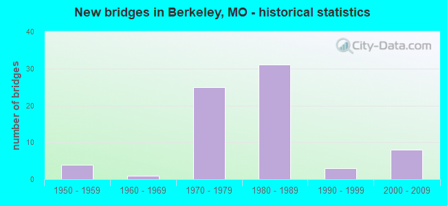
- New bridges - historical statistics
- 41950-1959
- 11960-1969
- 251970-1979
- 311980-1989
- 31990-1999
- 82000-2009

- Reconstructed bridges - Historical Statistics
- 21980-1989
- 11990-1999
- 22000-2009
- 12010-2019


- Bridge Condition - Deck
- 3.2%Very good
- 35.5%Good
- 54.8%Satisfactory
- 3.2%Fair
- 3.2%Serious

- Bridge Condition - Superstructure
- 3.0%Very good
- 33.3%Good
- 33.3%Satisfactory
- 30.3%Fair

- Bridge Condition - Substructure
- 3.0%Very good
- 45.5%Good
- 42.4%Satisfactory
- 9.1%Fair

- Bridge Condition - Channel
- 22.2%Good
- 55.6%Satisfactory
- 22.2%Fair

- Bridge Condition - Culverts
- 33.3%Good
- 33.3%Satisfactory
- 33.3%Fair
Find on map >> Show street view
Structure Number: 1202, Location: S 9 T 35 N R 31 W (Lat: 37.824017, Lng: -94.361881), Route carried "on" structure: State highway BB, Year Built: 1967, Year Reconstructed: 1991, Status: Open, Structure Length: 3.57m (11.71ft), Average Daily Traffic: 3,999 (year 2021), Truck Traffic: 5%, Average Future Daily Traffic: 5,599 (year 2041), Design Load: H 15, Features Intersected: BIRCH CR
Minimum Vertical Clearance: 30+ m (98+ ft), Kilometerpoint: 1.493, Lanes on structure: 2, Owner: State Highway Agency, Approaching Roadway Width: 11.3m (37.1ft), Skew: 1 degrees, Material/Design: Steel, Design/Construction: Stringer/Multi-beam, Number Of Spans In Main Unit: 3, Length of Maximum Span: 12.2m (40.0ft), Curb or Sidewalk Widths: Left: 0.2m (0.7ft), Right: 0.2m (0.7ft), Curb-To-Curb Width: 8.5m (27.9ft), Out-to-Out Width: 9.4m (30.8ft)
Condition: Deck: Serious, Superstructure: Fair, Substructure: Fair, Channel: Good, Operating Rating: 45.9 metric tons, Method Used To Determine Operating Rating: Load Factor (LF), Inventory Rating: 27.0 metric tons, Method Used To Determine Inventory Rating: Load Factor (LF), Structural Evaluation: Somewhat better than minimum adequacy, Deck Geometry: Meets minimum limits, Waterway Adequacy: Equal to present desirable criteria, Approach Roadway Alignment: Equal to present minimum criteria, Length Of Structure Improvement: 0.45m (1.48ft), Designated Inspection Frequency: Every 24 months, Inspection Date: June 2021, Bridge Improvement Cost: $386,000, Roadway Improvement Cost: $39,000, Total Project Cost: $580,000 ( Estimate for 2022), Deck Structure Type: Concrete Cast-file-Place, Wearing Surface/Protective System: Wearing Surface: Bituminous
Find on map >> Show street view
Structure Number: 1202, Location: S 15 T 46 N R 6 E (Lat: 38.724586, Lng: -90.325072), Route carried "on" structure: Interstate 70, Year Built: 2000, Status: Open, Structure Length: 5.15m (16.90ft), Average Daily Traffic: 58,610 (year 2021), Truck Traffic: 18%, Average Future Daily Traffic: 73,263 (year 2041), Design Load: HS 25 or greater, Features Intersected: CST SPRINGDALE AVE
Minimum Vertical Clearance: 30+ m (98+ ft), Kilometerpoint: 385.194, Lanes on structure: 4, Lanes under structure: 2, Base Highway Network: Yes, Owner: State Highway Agency, Approaching Roadway Width: 21.6m (70.9ft), Skew: 3 degrees, Material/Design: Prestressed concrete continuous, Design/Construction: Stringer/Multi-beam, Number Of Spans In Main Unit: 3, Length of Maximum Span: 17.3m (56.8ft), Curb-To-Curb Width: 20.6m (67.6ft), Out-to-Out Width: 21.4m (70.2ft)
Condition: Deck: Good, Superstructure: Good, Substructure: Very good, Operating Rating: 74.7 metric tons, Method Used To Determine Operating Rating: Load Factor (LF), Inventory Rating: 44.1 metric tons, Method Used To Determine Inventory Rating: Load Factor (LF), Structural Evaluation: Better than present minimum criteria, Deck Geometry: Equal to present minimum criteria, Underclear: Somewhat better than minimum adequacy, Approach Roadway Alignment: Equal to present desirable criteria, Designated Inspection Frequency: Every 24 months, Inspection Date: September 2020, Deck Structure Type: Concrete Cast-file-Place, Wearing Surface/Protective System: Wearing Surface: Monolithic Concrete, Deck Protection: Epoxy Coated Reinforcing
Find on map >> Show street view
Structure Number: 12021, Location: S 15 T 46 N R 6 E (Lat: 38.724808, Lng: -90.325000), Route carried "on" structure: Interstate 70, Year Built: 2000, Status: Open, Structure Length: 5.15m (16.90ft), Average Daily Traffic: 59,998 (year 2021), Truck Traffic: 18%, Average Future Daily Traffic: 74,998 (year 2041), Design Load: HS 25 or greater, Features Intersected: CST SPRINGDALE AVE
Minimum Vertical Clearance: 30+ m (98+ ft), Kilometerpoint: 17.288, Lanes on structure: 5, Lanes under structure: 2, Base Highway Network: Yes, Owner: State Highway Agency, Approaching Roadway Width: 22.3m (73.2ft), Skew: 3 degrees, Material/Design: Prestressed concrete continuous, Design/Construction: Stringer/Multi-beam, Number Of Spans In Main Unit: 3, Length of Maximum Span: 17.3m (56.8ft), Curb-To-Curb Width: 23.0m (75.5ft), Out-to-Out Width: 23.8m (78.1ft)
Condition: Deck: Good, Superstructure: Good, Substructure: Good, Operating Rating: 78.3 metric tons, Method Used To Determine Operating Rating: Load Factor (LF), Inventory Rating: 46.8 metric tons, Method Used To Determine Inventory Rating: Load Factor (LF), Structural Evaluation: Better than present minimum criteria, Deck Geometry: Somewhat better than minimum adequacy, Underclear: Somewhat better than minimum adequacy, Approach Roadway Alignment: Equal to present desirable criteria, Designated Inspection Frequency: Every 24 months, Inspection Date: September 2020, Deck Structure Type: Concrete Cast-file-Place, Wearing Surface/Protective System: Wearing Surface: Monolithic Concrete, Deck Protection: Epoxy Coated Reinforcing
Find on map >> Show street view
Structure Number: 12074, Location: S 3082 T 46 N R 6 E (Lat: 38.720800, Lng: -90.317153), Route carried "on" structure: City street , Year Built: 2001, Status: Open, Structure Length: 5.43m (17.81ft), Average Daily Traffic: 12,660 (year 2021), Truck Traffic: 5%, Average Future Daily Traffic: 17,724 (year 2041), Design Load: HS 20+Mod, Features Intersected: IS 70, Facility Carried by Structure: NORTH HANLEY RD S
Minimum Vertical Clearance: 30+ m (98+ ft), Kilometerpoint: 6.824, Lanes on structure: 6, Lanes under structure: 8, Base Highway Network: Yes, Owner: State Highway Agency, Approaching Roadway Width: 23.8m (78.1ft), Skew: 20 degrees, Material/Design: Steel continuous, Design/Construction: Stringer/Multi-beam, Number Of Spans In Main Unit: 2, Length of Maximum Span: 28.9m (94.8ft), Curb or Sidewalk Widths: Left: 1.8m (5.9ft), Right: 1.8m (5.9ft), Curb-To-Curb Width: 23.8m (78.1ft), Out-to-Out Width: 24.6m (80.7ft)
Condition: Deck: Satisfactory, Superstructure: Satisfactory, Substructure: Good, Operating Rating: 74.7 metric tons, Method Used To Determine Operating Rating: Load Factor (LF), Inventory Rating: 45.0 metric tons, Method Used To Determine Inventory Rating: Load Factor (LF), Structural Evaluation: Equal to present minimum criteria, Deck Geometry: Somewhat better than minimum adequacy, Underclear: High priority of corrective action, Approach Roadway Alignment: Equal to present desirable criteria, Designated Inspection Frequency: Every 24 months, Inspection Date: September 2020, Deck Structure Type: Concrete Cast-file-Place, Wearing Surface/Protective System: Wearing Surface: Monolithic Concrete, Deck Protection: Epoxy Coated Reinforcing
Find on map >> Show street view
Structure Number: 13253, Location: S 3 T 46 N R 6 E (Lat: 38.758097, Lng: -90.337825), Route carried "on" structure: City street , Year Built: 1995, Status: Open, Structure Length: 1.16m (3.81ft), Average Daily Traffic: 1,000 (year 2020), Truck Traffic: 10%, Average Future Daily Traffic: 1,350 (year 2040), Design Load: HS 25 or greater, Features Intersected: BR OF COLDWATER CR, Facility Carried by Structure: GRAHAM RD
Minimum Vertical Clearance: 30+ m (98+ ft), Kilometerpoint: 0.161, Lanes on structure: 2, Owner: City or Municipal Highway Agency, Approaching Roadway Width: 7.9m (25.9ft), Material/Design: Prestressed concrete, Design/Construction: Box Beam or Girders - Multiple, Number Of Spans In Main Unit: 1, Length of Maximum Span: 11.0m (36.1ft), Curb-To-Curb Width: 7.9m (25.9ft), Out-to-Out Width: 9.8m (32.2ft)
Condition: Deck: Very good, Superstructure: Very good, Substructure: Good, Channel: Satisfactory, Operating Rating: 54.0 metric tons, Method Used To Determine Operating Rating: Load Factor (LF), Inventory Rating: 32.4 metric tons, Method Used To Determine Inventory Rating: Load Factor (LF), Structural Evaluation: Better than present minimum criteria, Deck Geometry: Somewhat better than minimum adequacy, Waterway Adequacy: Equal to present desirable criteria, Approach Roadway Alignment: Equal to present desirable criteria, Designated Inspection Frequency: Every 24 months, Inspection Date: December 2021, Deck Structure Type: Concrete Precast Panels, Wearing Surface/Protective System: Wearing Surface: Bituminous
Find on map >> Show street view
Structure Number: 15551, Location: S 15 T 46 N R 6 E (Lat: 38.729769, Lng: -90.324339), Route carried "on" structure: County highway , Year Built: 1974, Status: Posted for load, Structure Length: 2.80m (9.19ft), Average Daily Traffic: 7,675 (year 2020), Truck Traffic: 10%, Average Future Daily Traffic: 10,361 (year 2040), Design Load: HS 20, Features Intersected: MALINE CR, Facility Carried by Structure: N HANLEY RD
Minimum Vertical Clearance: 30+ m (98+ ft), Kilometerpoint: 0.000, Lanes on structure: 4, Owner: County Highway Agency, Approaching Roadway Width: 16.2m (53.1ft), Material/Design: Concrete, Design/Construction: Slab, Number Of Spans In Main Unit: 3, Length of Maximum Span: 10.4m (34.1ft), Curb or Sidewalk Widths: Left: 1.2m (3.9ft), Right: 1.2m (3.9ft), Curb-To-Curb Width: 16.2m (53.1ft), Out-to-Out Width: 19.9m (65.3ft)
Condition: Deck: Satisfactory, Superstructure: Fair, Substructure: Good, Channel: Good, Operating Rating: 45.0 metric tons, Method Used To Determine Operating Rating: Allowable Stress (AS), Inventory Rating: 22.5 metric tons, Method Used To Determine Inventory Rating: Allowable Stress (AS), Structural Evaluation: Somewhat better than minimum adequacy, Deck Geometry: Meets minimum limits, Waterway Adequacy: Superior to present desirable criteria, Approach Roadway Alignment: Better than present minimum criteria, Designated Inspection Frequency: Every 24 months, Inspection Date: April 2020, Deck Structure Type: Concrete Cast-file-Place, Wearing Surface/Protective System: Wearing Surface: Monolithic Concrete
Find on map >> Show street view
Structure Number: 15558, Location: S 3 T 46 N R 6 E (Lat: 38.755356, Lng: -90.334486), Route carried "on" structure: County highway , Year Built: 1974, Year Reconstructed: 1996, Status: Posted for load, Structure Length: 12.44m (40.81ft), Average Daily Traffic: 8,376 (year 2020), Truck Traffic: 10%, Average Future Daily Traffic: 11,308 (year 2040), Design Load: HS 20, Features Intersected: WABASH AVE, BNSF RR, CRE, Facility Carried by Structure: NORTH HANLEY RD
Minimum Vertical Clearance: 30+ m (98+ ft), Kilometerpoint: 0.000, Lanes on structure: 4, Lanes under structure: 2, Owner: County Highway Agency, Approaching Roadway Width: 19.2m (63.0ft), Material/Design: Steel continuous, Design/Construction: Stringer/Multi-beam, Number Of Spans In Main Unit: 3, Number Of Approach Spans: 4, Length of Maximum Span: 22.9m (75.1ft), Curb or Sidewalk Widths: Left: 1.1m (3.6ft), Right: 1.1m (3.6ft), Curb-To-Curb Width: 22.5m (73.8ft), Out-to-Out Width: 22.5m (73.8ft)
Condition: Deck: Fair, Superstructure: Fair, Substructure: Fair, Channel: Fair, Operating Rating: 70.2 metric tons, Method Used To Determine Operating Rating: Load Factor (LF), Inventory Rating: 42.3 metric tons, Method Used To Determine Inventory Rating: Load Factor (LF), Structural Evaluation: Somewhat better than minimum adequacy, Deck Geometry: Superior to present desirable criteria, Underclear: High priority of corrective action, Waterway Adequacy: Equal to present desirable criteria, Approach Roadway Alignment: Equal to present minimum criteria, Designated Inspection Frequency: Every 24 months, Inspection Date: April 2020, Deck Structure Type: Concrete Cast-file-Place, Wearing Surface/Protective System: Wearing Surface: Monolithic Concrete, Membrane: Other, Deck Protection: Epoxy Coated Reinforcing
Find on map >> Show street view
Structure Number: 2499, Location: S 2979 T 47 N R 6 E (Lat: 38.770394, Lng: -90.339047), Route carried "on" structure: Interstate 170, Year Built: 1978, Year Reconstructed: 2007, Status: Open, Structure Length: 7.58m (24.87ft), Average Daily Traffic: 34,144 (year 2021), Truck Traffic: 12%, Average Future Daily Traffic: 42,680 (year 2041), Design Load: HS 20+Mod, Features Intersected: CST NYFLOT AVE
Minimum Vertical Clearance: 30+ m (98+ ft), Kilometerpoint: 0.816, Lanes on structure: 3, Lanes under structure: 2, Base Highway Network: Yes, Owner: State Highway Agency, Approaching Roadway Width: 15.8m (51.8ft), Skew: 13 degrees, Material/Design: Steel continuous, Design/Construction: Stringer/Multi-beam, Number Of Spans In Main Unit: 4, Length of Maximum Span: 21.6m (70.9ft), Curb-To-Curb Width: 15.8m (51.8ft), Out-to-Out Width: 16.7m (54.8ft)
Condition: Deck: Good, Superstructure: Good, Substructure: Satisfactory, Operating Rating: 58.5 metric tons, Method Used To Determine Operating Rating: Load Factor (LF), Inventory Rating: 35.1 metric tons, Method Used To Determine Inventory Rating: Load Factor (LF), Structural Evaluation: Equal to present minimum criteria, Deck Geometry: Somewhat better than minimum adequacy, Underclear: Better than present minimum criteria, Approach Roadway Alignment: Equal to present desirable criteria, Designated Inspection Frequency: Every 24 months, Inspection Date: September 2020, Deck Structure Type: Concrete Cast-file-Place, Wearing Surface/Protective System: Wearing Surface: Other
Find on map >> Show street view
Structure Number: 25, Location: S 3 T 58 N R 31 W (Lat: 39.874569, Lng: -94.359803), Route carried "on" structure: State highway 33, Year Built: 1959, Year Reconstructed: 2009, Status: Open, Structure Length: 4.54m (14.90ft), Average Daily Traffic: 1,871 (year 2021), Truck Traffic: 7%, Average Future Daily Traffic: 2,432 (year 2041), Design Load: H 20, Features Intersected: BR LOST CR
Minimum Vertical Clearance: 30+ m (98+ ft), Kilometerpoint: 1.642, Lanes on structure: 2, Owner: State Highway Agency, Approaching Roadway Width: 11.0m (36.1ft), Material/Design: Steel continuous, Design/Construction: Stringer/Multi-beam, Number Of Spans In Main Unit: 3, Length of Maximum Span: 17.1m (56.1ft), Curb-To-Curb Width: 9.8m (32.2ft), Out-to-Out Width: 10.6m (34.8ft)
Condition: Deck: Good, Superstructure: Good, Substructure: Good, Channel: Satisfactory, Operating Rating: 51.3 metric tons, Method Used To Determine Operating Rating: Load Factor (LF), Inventory Rating: 30.6 metric tons, Method Used To Determine Inventory Rating: Load Factor (LF), Structural Evaluation: Better than present minimum criteria, Deck Geometry: Somewhat better than minimum adequacy, Waterway Adequacy: Equal to present desirable criteria, Approach Roadway Alignment: Equal to present desirable criteria, Designated Inspection Frequency: Every 24 months, Inspection Date: December 2021, Deck Structure Type: Concrete Cast-file-Place, Wearing Surface/Protective System: Wearing Surface: Monolithic Concrete, Membrane: Built-up, Deck Protection: Epoxy Coated Reinforcing
Find on map >> Show street view
Structure Number: 25, Location: S 2979 T 47 N R 6 E (Lat: 38.770367, Lng: -90.338744), Route carried "on" structure: Interstate 170, Year Built: 1978, Status: Open, Structure Length: 7.53m (24.70ft), Average Daily Traffic: 31,358 (year 2021), Truck Traffic: 18%, Average Future Daily Traffic: 39,198 (year 2041), Design Load: HS 20+Mod, Features Intersected: CST NYFLOT AVE
Minimum Vertical Clearance: 30+ m (98+ ft), Kilometerpoint: 17.033, Lanes on structure: 2, Lanes under structure: 2, Base Highway Network: Yes, Owner: State Highway Agency, Approaching Roadway Width: 12.2m (40.0ft), Skew: 13 degrees, Material/Design: Steel continuous, Design/Construction: Stringer/Multi-beam, Number Of Spans In Main Unit: 4, Length of Maximum Span: 21.6m (70.9ft), Curb-To-Curb Width: 12.0m (39.4ft), Out-to-Out Width: 12.9m (42.3ft)
Condition: Deck: Good, Superstructure: Good, Substructure: Satisfactory, Operating Rating: 60.3 metric tons, Method Used To Determine Operating Rating: Load Factor (LF), Inventory Rating: 36.0 metric tons, Method Used To Determine Inventory Rating: Load Factor (LF), Structural Evaluation: Equal to present minimum criteria, Deck Geometry: Equal to present minimum criteria, Underclear: Superior to present desirable criteria, Approach Roadway Alignment: Better than present minimum criteria, Designated Inspection Frequency: Every 24 months, Inspection Date: September 2020, Deck Structure Type: Concrete Cast-file-Place, Wearing Surface/Protective System: Wearing Surface: Other, Membrane: Built-up
Find on map >> Show street view
Structure Number: 2512, Location: S 2979 T 46 N R 6 E (Lat: 38.756883, Lng: -90.339628), Route carried "on" structure: Interstate 170, Year Built: 1980, Status: Open, Structure Length: 37.03m (121.49ft), Average Daily Traffic: 50,437 (year 2021), Truck Traffic: 12%, Average Future Daily Traffic: 63,046 (year 2041), Design Load: HS 20+Mod, Features Intersected: RP BOEING RD TO IS170E,,
Minimum Vertical Clearance: 30+ m (98+ ft), Kilometerpoint: 2.224, Lanes on structure: 4, Lanes under structure: 2, Base Highway Network: Yes, Owner: State Highway Agency, Approaching Roadway Width: 17.1m (56.1ft), Skew: 1 degrees, Material/Design: Steel continuous, Design/Construction: Stringer/Multi-beam, Number Of Spans In Main Unit: 15, Length of Maximum Span: 29.6m (97.1ft), Curb-To-Curb Width: 17.1m (56.1ft), Out-to-Out Width: 17.9m (58.7ft)
Condition: Deck: Satisfactory, Superstructure: Fair, Substructure: Satisfactory, Channel: Satisfactory, Operating Rating: 54.0 metric tons, Method Used To Determine Operating Rating: Load Factor (LF), Inventory Rating: 32.4 metric tons, Method Used To Determine Inventory Rating: Load Factor (LF), Structural Evaluation: Somewhat better than minimum adequacy, Deck Geometry: Meets minimum limits, Underclear: Superior to present desirable criteria, Waterway Adequacy: Equal to present desirable criteria, Approach Roadway Alignment: Equal to present desirable criteria, Designated Inspection Frequency: Every 24 months, Inspection Date: June 2020, Deck Structure Type: Concrete Cast-file-Place, Wearing Surface/Protective System: Wearing Surface: Epoxy Overlay, Deck Protection: Epoxy Coated Reinforcing
Find on map >> Show street view
Structure Number: 25376, Location: S 15 T 46 N R 6 E (Lat: 38.719878, Lng: -90.317119), Route carried "on" structure: County highway , Year Built: 1992, Status: Open, Structure Length: 1.22m (4.00ft), Average Daily Traffic: 15,183 (year 2020), Truck Traffic: 3%, Average Future Daily Traffic: 20,497 (year 2040), Design Load: HS 20, Features Intersected: METROLINK, Facility Carried by Structure: N HANLEY RD
Minimum Vertical Clearance: 30+ m (98+ ft), Kilometerpoint: 0.322, Lanes on structure: 5, Owner: Local Agency, Approaching Roadway Width: 23.2m (76.1ft), Material/Design: Concrete, Design/Construction: Frame, Number Of Spans In Main Unit: 1, Length of Maximum Span: 12.2m (40.0ft), Curb-To-Curb Width: 21.9m (71.9ft), Out-to-Out Width: 23.2m (76.1ft)
Condition: Superstructure: Satisfactory, Substructure: Satisfactory, Inventory Rating: 66.6 metric tons, Method Used To Determine Inventory Rating: Load Factor (LF), Structural Evaluation: Equal to present minimum criteria, Deck Geometry: Somewhat better than minimum adequacy, Underclear: High priority of corrective action, Approach Roadway Alignment: Equal to present minimum criteria, Designated Inspection Frequency: Every 24 months, Inspection Date: January 2022
Find on map >> Show street view
Structure Number: 25378, Location: S 4 T 46 N R 6 E (Lat: 38.733631, Lng: -90.343764), Route carried "on" structure: County highway , Year Built: 1993, Status: Open, Structure Length: 1.10m (3.61ft), Average Daily Traffic: 3,079 (year 2020), Truck Traffic: 1%, Average Future Daily Traffic: 4,157 (year 2040), Features Intersected: METROLINK, Facility Carried by Structure: MC DONNELL BLVD
Minimum Vertical Clearance: 30+ m (98+ ft), Kilometerpoint: 0.322, Lanes on structure: 3, Owner: Local Agency, Approaching Roadway Width: 13.4m (44.0ft), Material/Design: Concrete, Design/Construction: Frame, Number Of Spans In Main Unit: 1, Length of Maximum Span: 9.4m (30.8ft), Curb-To-Curb Width: 13.4m (44.0ft), Out-to-Out Width: 13.4m (44.0ft)
Condition: Superstructure: Good, Substructure: Good, Operating Rating: 91.8 metric tons, Method Used To Determine Operating Rating: Load Factor (LF), Inventory Rating: 54.9 metric tons, Method Used To Determine Inventory Rating: Load Factor (LF), Structural Evaluation: Better than present minimum criteria, Deck Geometry: Somewhat better than minimum adequacy, Underclear: High priority of corrective action, Approach Roadway Alignment: Equal to present desirable criteria, Designated Inspection Frequency: Every 24 months, Inspection Date: January 2022
Find on map >> Show street view
Structure Number: 2561, Location: S 2 T 46 N R 6 E (Lat: 38.762833, Lng: -90.338756), Route carried "on" structure: Interstate 170, Year Built: 1978, Status: Open, Structure Length: 5.03m (16.50ft), Average Daily Traffic: 34,144 (year 2021), Truck Traffic: 12%, Average Future Daily Traffic: 42,680 (year 2041), Design Load: HS 20+Mod, Features Intersected: CST FROST AVE
Minimum Vertical Clearance: 30+ m (98+ ft), Kilometerpoint: 1.688, Lanes on structure: 3, Lanes under structure: 4, Base Highway Network: Yes, Owner: State Highway Agency, Approaching Roadway Width: 12.2m (40.0ft), Material/Design: Steel, Design/Construction: Stringer/Multi-beam, Number Of Spans In Main Unit: 3, Length of Maximum Span: 27.7m (90.9ft), Curb-To-Curb Width: 12.0m (39.4ft), Out-to-Out Width: 12.9m (42.3ft)
Condition: Deck: Good, Superstructure: Fair, Substructure: Satisfactory, Operating Rating: 68.4 metric tons, Method Used To Determine Operating Rating: Load Factor (LF), Inventory Rating: 41.4 metric tons, Method Used To Determine Inventory Rating: Load Factor (LF), Structural Evaluation: Somewhat better than minimum adequacy, Deck Geometry: High priority of replacement, Underclear: Superior to present desirable criteria, Approach Roadway Alignment: Equal to present desirable criteria, Length Of Structure Improvement: 0.60m (1.97ft), Designated Inspection Frequency: Every 24 months, Other Special Inspection Frequency: Every 24 months, Inspection Date: September 2020, Other Special Inspection Date: March 2021, Bridge Improvement Cost: $635,000, Roadway Improvement Cost: $63,000, Total Project Cost: $952,000 ( Estimate for 2022), Deck Structure Type: Concrete Cast-file-Place, Wearing Surface/Protective System: Wearing Surface: Other, Membrane: Built-up
Find on map >> Show street view
Structure Number: 2562, Location: S 2 T 46 N R 6 E (Lat: 38.762819, Lng: -90.338517), Route carried "on" structure: Interstate 170, Year Built: 1978, Status: Open, Structure Length: 4.91m (16.11ft), Average Daily Traffic: 31,358 (year 2021), Truck Traffic: 18%, Average Future Daily Traffic: 39,198 (year 2041), Design Load: HS 20+Mod, Features Intersected: CST FROST AVE
Minimum Vertical Clearance: 30+ m (98+ ft), Kilometerpoint: 16.195, Lanes on structure: 2, Lanes under structure: 5, Base Highway Network: Yes, Owner: State Highway Agency, Approaching Roadway Width: 12.2m (40.0ft), Material/Design: Steel, Design/Construction: Stringer/Multi-beam, Number Of Spans In Main Unit: 3, Length of Maximum Span: 27.7m (90.9ft), Curb-To-Curb Width: 12.0m (39.4ft), Out-to-Out Width: 12.9m (42.3ft)
Condition: Deck: Satisfactory, Superstructure: Satisfactory, Substructure: Satisfactory, Operating Rating: 68.4 metric tons, Method Used To Determine Operating Rating: Load Factor (LF), Inventory Rating: 40.5 metric tons, Method Used To Determine Inventory Rating: Load Factor (LF), Structural Evaluation: Equal to present minimum criteria, Deck Geometry: Equal to present minimum criteria, Underclear: Better than present minimum criteria, Approach Roadway Alignment: Equal to present desirable criteria, Designated Inspection Frequency: Every 24 months, Other Special Inspection Frequency: Every 24 months, Inspection Date: September 2020, Other Special Inspection Date: March 2021, Deck Structure Type: Concrete Cast-file-Place, Wearing Surface/Protective System: Wearing Surface: Other
Find on map >> Show street view
Structure Number: 2563, Location: S 2 T 46 N R 6 E (Lat: 38.761436, Lng: -90.338972), Route carried "on" structure: Interstate 170, Year Built: 1978, Status: Open, Structure Length: 4.54m (14.90ft), Average Daily Traffic: 34,144 (year 2021), Truck Traffic: 12%, Average Future Daily Traffic: 42,680 (year 2041), Design Load: HS 20+Mod, Features Intersected: RP FROST AVE TO IS170E
Minimum Vertical Clearance: 30+ m (98+ ft), Kilometerpoint: 1.848, Lanes on structure: 3, Lanes under structure: 2, Base Highway Network: Yes, Owner: State Highway Agency, Approaching Roadway Width: 12.2m (40.0ft), Skew: 3 degrees, Material/Design: Concrete continuous, Design/Construction: Slab, Number Of Spans In Main Unit: 3, Length of Maximum Span: 19.8m (65.0ft), Curb-To-Curb Width: 12.0m (39.4ft), Out-to-Out Width: 12.9m (42.3ft)
Condition: Deck: Good, Superstructure: Good, Substructure: Good, Operating Rating: 77.4 metric tons, Method Used To Determine Operating Rating: Load Factor (LF), Inventory Rating: 46.8 metric tons, Method Used To Determine Inventory Rating: Load Factor (LF), Structural Evaluation: Better than present minimum criteria, Deck Geometry: High priority of replacement, Underclear: Equal to present minimum criteria, Approach Roadway Alignment: Equal to present desirable criteria, Length Of Structure Improvement: 0.55m (1.80ft), Designated Inspection Frequency: Every 24 months, Inspection Date: September 2020, Bridge Improvement Cost: $580,000, Roadway Improvement Cost: $58,000, Total Project Cost: $870,000 ( Estimate for 2022), Deck Structure Type: Concrete Cast-file-Place, Wearing Surface/Protective System: Wearing Surface: Other, Membrane: Built-up
Find on map >> Show street view
Structure Number: 2564, Location: S 2 T 46 N R 6 E (Lat: 38.761486, Lng: -90.338706), Route carried "on" structure: Interstate 170, Year Built: 1978, Status: Open, Structure Length: 4.05m (13.29ft), Average Daily Traffic: 31,358 (year 2021), Truck Traffic: 18%, Average Future Daily Traffic: 39,198 (year 2041), Design Load: HS 20+Mod, Features Intersected: RP FROST AVE TO IS170E
Minimum Vertical Clearance: 30+ m (98+ ft), Kilometerpoint: 16.039, Lanes on structure: 2, Lanes under structure: 2, Base Highway Network: Yes, Owner: State Highway Agency, Approaching Roadway Width: 12.2m (40.0ft), Skew: 2 degrees, Material/Design: Concrete continuous, Design/Construction: Slab, Number Of Spans In Main Unit: 3, Length of Maximum Span: 17.7m (58.1ft), Curb-To-Curb Width: 12.0m (39.4ft), Out-to-Out Width: 12.9m (42.3ft)
Condition: Deck: Good, Superstructure: Satisfactory, Substructure: Good, Operating Rating: 77.4 metric tons, Method Used To Determine Operating Rating: Load Factor (LF), Inventory Rating: 45.9 metric tons, Method Used To Determine Inventory Rating: Load Factor (LF), Structural Evaluation: Equal to present minimum criteria, Deck Geometry: Equal to present minimum criteria, Underclear: Better than present minimum criteria, Approach Roadway Alignment: Equal to present desirable criteria, Designated Inspection Frequency: Every 24 months, Inspection Date: September 2020, Deck Structure Type: Concrete Cast-file-Place, Wearing Surface/Protective System: Wearing Surface: Other, Membrane: Built-up
Find on map >> Show street view
Structure Number: 2565, Location: S 2979 T 46 N R 6 E (Lat: 38.749706, Lng: -90.338272), Route carried "on" structure: Interstate 170, Year Built: 1980, Status: Open, Structure Length: 5.73m (18.80ft), Average Daily Traffic: 50,437 (year 2021), Truck Traffic: 12%, Average Future Daily Traffic: 63,046 (year 2041), Design Load: HS 20+Mod, Features Intersected: CST AIRPORT RD
Minimum Vertical Clearance: 30+ m (98+ ft), Kilometerpoint: 3.166, Lanes on structure: 4, Lanes under structure: 6, Base Highway Network: Yes, Owner: State Highway Agency, Approaching Roadway Width: 17.1m (56.1ft), Skew: 10 degrees, Material/Design: Steel continuous, Design/Construction: Stringer/Multi-beam, Number Of Spans In Main Unit: 2, Length of Maximum Span: 28.7m (94.2ft), Curb-To-Curb Width: 17.1m (56.1ft), Out-to-Out Width: 17.9m (58.7ft)
Condition: Deck: Satisfactory, Superstructure: Satisfactory, Substructure: Satisfactory, Operating Rating: 57.6 metric tons, Method Used To Determine Operating Rating: Load Factor (LF), Inventory Rating: 34.2 metric tons, Method Used To Determine Inventory Rating: Load Factor (LF), Structural Evaluation: Equal to present minimum criteria, Deck Geometry: High priority of corrective action, Underclear: Somewhat better than minimum adequacy, Approach Roadway Alignment: Equal to present desirable criteria, Designated Inspection Frequency: Every 24 months, Inspection Date: September 2020, Deck Structure Type: Concrete Cast-file-Place, Wearing Surface/Protective System: Wearing Surface: Epoxy Overlay, Deck Protection: Epoxy Coated Reinforcing
Find on map >> Show street view
Structure Number: 2566, Location: S 2979 T 46 N R 6 E (Lat: 38.749694, Lng: -90.337722), Route carried "on" structure: Interstate 170, Year Built: 1980, Status: Open, Structure Length: 5.85m (19.19ft), Average Daily Traffic: 47,050 (year 2021), Truck Traffic: 18%, Average Future Daily Traffic: 58,813 (year 2041), Design Load: HS 20+Mod, Features Intersected: CST AIRPORT RD
Minimum Vertical Clearance: 30+ m (98+ ft), Kilometerpoint: 14.724, Lanes on structure: 3, Lanes under structure: 6, Base Highway Network: Yes, Owner: State Highway Agency, Approaching Roadway Width: 17.1m (56.1ft), Skew: 10 degrees, Material/Design: Steel continuous, Design/Construction: Stringer/Multi-beam, Number Of Spans In Main Unit: 2, Length of Maximum Span: 29.3m (96.1ft), Curb-To-Curb Width: 17.1m (56.1ft), Out-to-Out Width: 17.9m (58.7ft)
Condition: Deck: Satisfactory, Superstructure: Fair, Substructure: Fair, Operating Rating: 54.9 metric tons, Method Used To Determine Operating Rating: Load Factor (LF), Inventory Rating: 32.4 metric tons, Method Used To Determine Inventory Rating: Load Factor (LF), Structural Evaluation: Somewhat better than minimum adequacy, Deck Geometry: Equal to present minimum criteria, Underclear: Meets minimum limits, Approach Roadway Alignment: Equal to present desirable criteria, Designated Inspection Frequency: Every 24 months, Inspection Date: September 2020, Deck Structure Type: Concrete Cast-file-Place, Wearing Surface/Protective System: Wearing Surface: Epoxy Overlay, Deck Protection: Epoxy Coated Reinforcing
Find on map >> Show street view
Structure Number: 2567, Location: S 10 T 46 N R 6 E (Lat: 38.741297, Lng: -90.336058), Route carried "on" structure: City street , Year Built: 1977, Year Reconstructed: 1994, Status: Open, Structure Length: 10.79m (35.40ft), Average Daily Traffic: 2,176 (year 2021), Truck Traffic: 5%, Average Future Daily Traffic: 3,264 (year 2041), Design Load: HS 20, Features Intersected: IS 170, Facility Carried by Structure: SCUDDER AVE E
Minimum Vertical Clearance: 30+ m (98+ ft), Kilometerpoint: 0.435, Lanes on structure: 4, Lanes under structure: 10, Owner: State Highway Agency, Approaching Roadway Width: 7.3m (24.0ft), Skew: 23 degrees, Material/Design: Steel continuous, Design/Construction: Stringer/Multi-beam, Number Of Spans In Main Unit: 4, Length of Maximum Span: 36.6m (120.1ft), Curb or Sidewalk Widths: Left: 1.7m (5.6ft), Right: 0.2m (0.7ft), Curb-To-Curb Width: 20.7m (67.9ft), Out-to-Out Width: 21.7m (71.2ft)
Condition: Deck: Satisfactory, Superstructure: Fair, Substructure: Satisfactory, Operating Rating: 60.3 metric tons, Method Used To Determine Operating Rating: Load Factor (LF), Inventory Rating: 36.0 metric tons, Method Used To Determine Inventory Rating: Load Factor (LF), Structural Evaluation: Somewhat better than minimum adequacy, Deck Geometry: Superior to present desirable criteria, Underclear: Equal to present minimum criteria, Approach Roadway Alignment: Equal to present desirable criteria, Designated Inspection Frequency: Every 24 months, Inspection Date: September 2020, Deck Structure Type: Concrete Cast-file-Place, Wearing Surface/Protective System: Wearing Surface: Other, Membrane: Built-up, Deck Protection: Bituminous
Find on map >> Show street view
Structure Number: 2568, Location: S 656 T 46 N R 6 E (Lat: 38.732522, Lng: -90.333028), Route carried "on" structure: Ramp State highway , Year Built: 1981, Status: Open, Structure Length: 5.94m (19.49ft), Average Daily Traffic: 2,066 (year 2021), Truck Traffic: 1%, Average Future Daily Traffic: 2,583 (year 2041), Design Load: HS 20+Mod, Features Intersected: IS 170, Facility Carried by Structure: RP IS170W TO IS70W
Minimum Vertical Clearance: 30+ m (98+ ft), Kilometerpoint: 0.301, Lanes on structure: 1, Lanes under structure: 3, Base Highway Network: Yes, Owner: State Highway Agency, Approaching Roadway Width: 9.8m (32.2ft), Skew: 1 degrees, Material/Design: Steel continuous, Design/Construction: Stringer/Multi-beam, Number Of Spans In Main Unit: 3, Length of Maximum Span: 31.8m (104.3ft), Curb or Sidewalk Widths: Left: 0.2m (0.7ft), Right: 0.2m (0.7ft), Curb-To-Curb Width: 9.8m (32.2ft), Out-to-Out Width: 10.6m (34.8ft)
Condition: Deck: Good, Superstructure: Satisfactory, Substructure: Good, Operating Rating: 72.9 metric tons, Method Used To Determine Operating Rating: Load Factor (LF), Inventory Rating: 44.1 metric tons, Method Used To Determine Inventory Rating: Load Factor (LF), Structural Evaluation: Equal to present minimum criteria, Deck Geometry: Superior to present desirable criteria, Underclear: Superior to present desirable criteria, Approach Roadway Alignment: Better than present minimum criteria, Designated Inspection Frequency: Every 24 months, Inspection Date: September 2020, Deck Structure Type: Concrete Cast-file-Place, Wearing Surface/Protective System: Wearing Surface: Epoxy Overlay, Deck Protection: Epoxy Coated Reinforcing
Find on map >> Show street view
Structure Number: 2569, Location: S 656 T 46 N R 6 E (Lat: 38.731933, Lng: -90.331611), Route carried "on" structure: Ramp State highway , Year Built: 1981, Status: Open, Structure Length: 9.94m (32.61ft), Average Daily Traffic: 7,057 (year 2021), Truck Traffic: 10%, Average Future Daily Traffic: 8,821 (year 2041), Design Load: HS 20, Features Intersected: RP IS170W TO IS70W, Facility Carried by Structure: RP IS70E TO IS170W
Minimum Vertical Clearance: 30+ m (98+ ft), Kilometerpoint: 0.412, Lanes on structure: 1, Lanes under structure: 1, Base Highway Network: Yes, Owner: State Highway Agency, Approaching Roadway Width: 9.8m (32.2ft), Skew: 4 degrees, Material/Design: Steel continuous, Design/Construction: Stringer/Multi-beam, Number Of Spans In Main Unit: 4, Length of Maximum Span: 27.4m (89.9ft), Curb or Sidewalk Widths: Left: 0.2m (0.7ft), Right: 0.2m (0.7ft), Curb-To-Curb Width: 9.4m (30.8ft), Out-to-Out Width: 10.3m (33.8ft)
Condition: Deck: Satisfactory, Superstructure: Good, Substructure: Satisfactory, Operating Rating: 59.4 metric tons, Method Used To Determine Operating Rating: Load Factor (LF), Inventory Rating: 36.0 metric tons, Method Used To Determine Inventory Rating: Load Factor (LF), Structural Evaluation: Equal to present minimum criteria, Deck Geometry: Superior to present desirable criteria, Underclear: Equal to present minimum criteria, Approach Roadway Alignment: Equal to present minimum criteria, Designated Inspection Frequency: Every 24 months, Inspection Date: September 2020, Deck Structure Type: Concrete Cast-file-Place, Wearing Surface/Protective System: Wearing Surface: Epoxy Overlay, Deck Protection: Epoxy Coated Reinforcing
Find on map >> Show street view
Structure Number: 257, Location: S 4 T 49 N R 33 W (Lat: 39.095797, Lng: -94.556178), Route carried "on" structure: Interstate 70, Year Built: 1958, Year Reconstructed: 2010, Status: Open, Structure Length: 4.39m (14.40ft), Average Daily Traffic: 53,902 (year 2021), Truck Traffic: 18%, Average Future Daily Traffic: 72,768 (year 2041), Design Load: HS 20, Features Intersected: CST BROOKLYN AVE
Minimum Vertical Clearance: 30+ m (98+ ft), Kilometerpoint: 5.433, Lanes on structure: 4, Lanes under structure: 2, Base Highway Network: Yes, Owner: State Highway Agency, Approaching Roadway Width: 19.5m (64.0ft), Skew: 20 degrees, Material/Design: Concrete continuous, Design/Construction: Slab, Number Of Spans In Main Unit: 3, Length of Maximum Span: 19.5m (64.0ft), Curb or Sidewalk Widths: Left: 0.1m (0.3ft), Right: 0.2m (0.7ft), Curb-To-Curb Width: 18.2m (59.7ft), Out-to-Out Width: 20.4m (66.9ft)
Condition: Deck: Satisfactory, Superstructure: Satisfactory, Substructure: Good, Operating Rating: 69.3 metric tons, Method Used To Determine Operating Rating: Load Factor (LF), Inventory Rating: 41.4 metric tons, Method Used To Determine Inventory Rating: Load Factor (LF), Structural Evaluation: Equal to present minimum criteria, Deck Geometry: Meets minimum limits, Underclear: High priority of corrective action, Approach Roadway Alignment: Equal to present desirable criteria, Designated Inspection Frequency: Every 24 months, Inspection Date: September 2021, Deck Structure Type: Concrete Cast-file-Place, Wearing Surface/Protective System: Wearing Surface: Low Slump Concrete
Find on map >> Show street view
Structure Number: 257, Location: S 656 T 46 N R 6 E (Lat: 38.730372, Lng: -90.332439), Route carried "on" structure: Interstate 70, Year Built: 1979, Status: Open, Structure Length: 11.06m (36.29ft), Average Daily Traffic: 71,119 (year 2021), Truck Traffic: 18%, Average Future Daily Traffic: 88,899 (year 2041), Design Load: HS 20+Mod, Features Intersected: RP IS170E TO IS70E, IS 1
Minimum Vertical Clearance: 30+ m (98+ ft), Kilometerpoint: 18.168, Lanes on structure: 3, Lanes under structure: 3, Base Highway Network: Yes, Owner: State Highway Agency, Approaching Roadway Width: 20.7m (67.9ft), Skew: 13 degrees, Material/Design: Steel continuous, Design/Construction: Stringer/Multi-beam, Number Of Spans In Main Unit: 4, Length of Maximum Span: 35.1m (115.2ft), Curb or Sidewalk Widths: Left: 0.2m (0.7ft), Right: 0.2m (0.7ft), Curb-To-Curb Width: 20.7m (67.9ft), Out-to-Out Width: 21.6m (70.9ft)
Condition: Deck: Satisfactory, Superstructure: Fair, Substructure: Good, Operating Rating: 70.2 metric tons, Method Used To Determine Operating Rating: Load Factor (LF), Inventory Rating: 42.3 metric tons, Method Used To Determine Inventory Rating: Load Factor (LF), Structural Evaluation: Somewhat better than minimum adequacy, Deck Geometry: Superior to present desirable criteria, Underclear: Equal to present minimum criteria, Approach Roadway Alignment: Equal to present desirable criteria, Designated Inspection Frequency: Every 24 months, Inspection Date: September 2020, Deck Structure Type: Concrete Cast-file-Place, Wearing Surface/Protective System: Wearing Surface: Latex Concrete, Deck Protection: Epoxy Coated Reinforcing
Find on map >> Show street view
Structure Number: 2571, Location: S 656 T 46 N R 6 E (Lat: 38.730067, Lng: -90.332758), Route carried "on" structure: Ramp State highway , Year Built: 1981, Status: Open, Structure Length: 8.23m (27.00ft), Average Daily Traffic: 10,558 (year 2021), Truck Traffic: 18%, Average Future Daily Traffic: 13,198 (year 2041), Design Load: HS 20+Mod, Features Intersected: IS 170, Facility Carried by Structure: RP IS170W TO IS70W
Minimum Vertical Clearance: 5.18m (16.99ft), Kilometerpoint: 0.388, Lanes on structure: 1, Lanes under structure: 2, Base Highway Network: Yes, Owner: State Highway Agency, Approaching Roadway Width: 7.9m (25.9ft), Skew: 4 degrees, Material/Design: Steel continuous, Design/Construction: Girder and Floorbeam System, Number Of Spans In Main Unit: 3, Length of Maximum Span: 39.8m (130.6ft), Curb or Sidewalk Widths: Left: 0.2m (0.7ft), Right: 0.2m (0.7ft), Curb-To-Curb Width: 7.6m (24.9ft), Out-to-Out Width: 8.6m (28.2ft)
Condition: Deck: Good, Superstructure: Fair, Substructure: Good, Operating Rating: 63.0 metric tons, Method Used To Determine Operating Rating: Load Factor (LF), Inventory Rating: 37.8 metric tons, Method Used To Determine Inventory Rating: Load Factor (LF), Structural Evaluation: Somewhat better than minimum adequacy, Deck Geometry: Better than present minimum criteria, Underclear: Better than present minimum criteria, Approach Roadway Alignment: Equal to present desirable criteria, Designated Inspection Frequency: Every 24 months, Critical Feature Inspection Frequency: Every 24 months, Inspection Date: March 2021, Critical Feature Inspection Date: March 2021, Deck Structure Type: Concrete Cast-file-Place, Wearing Surface/Protective System: Wearing Surface: Monolithic Concrete, Deck Protection: Epoxy Coated Reinforcing
Find on map >> Show street view
Structure Number: 2572, Location: S 656 T 46 N R 6 E (Lat: 38.730303, Lng: -90.332544), Route carried "on" structure: Ramp State highway , Year Built: 1981, Status: Open, Structure Length: 12.16m (39.90ft), Average Daily Traffic: 7,057 (year 2021), Truck Traffic: 10%, Average Future Daily Traffic: 8,821 (year 2041), Design Load: HS 20, Features Intersected: IS 70, RP IS170W TO IS70, Facility Carried by Structure: RP IS70E TO IS170W
Minimum Vertical Clearance: 30+ m (98+ ft), Kilometerpoint: 0.200, Lanes on structure: 1, Lanes under structure: 7, Base Highway Network: Yes, Owner: State Highway Agency, Approaching Roadway Width: 9.8m (32.2ft), Material/Design: Steel continuous, Design/Construction: Stringer/Multi-beam, Number Of Spans In Main Unit: 4, Length of Maximum Span: 35.4m (116.1ft), Curb or Sidewalk Widths: Left: 0.2m (0.7ft), Right: 0.2m (0.7ft), Curb-To-Curb Width: 9.4m (30.8ft), Out-to-Out Width: 10.5m (34.4ft)
Condition: Deck: Satisfactory, Superstructure: Good, Substructure: Good, Operating Rating: 72.0 metric tons, Method Used To Determine Operating Rating: Load Factor (LF), Inventory Rating: 43.2 metric tons, Method Used To Determine Inventory Rating: Load Factor (LF), Structural Evaluation: Better than present minimum criteria, Deck Geometry: Superior to present desirable criteria, Underclear: High priority of corrective action, Approach Roadway Alignment: Equal to present minimum criteria, Designated Inspection Frequency: Every 24 months, Inspection Date: September 2020, Deck Structure Type: Concrete Cast-file-Place, Wearing Surface/Protective System: Wearing Surface: Monolithic Concrete, Deck Protection: Epoxy Coated Reinforcing
Find on map >> Show street view
Structure Number: 2573, Location: S 656 T 46 N R 6 E (Lat: 38.728889, Lng: -90.332431), Route carried "on" structure: Interstate 70, Year Built: 1979, Status: Open, Structure Length: 6.55m (21.49ft), Average Daily Traffic: 59,468 (year 2021), Truck Traffic: 18%, Average Future Daily Traffic: 74,335 (year 2041), Design Load: HS 20+Mod, Features Intersected: IS 170
Minimum Vertical Clearance: 30+ m (98+ ft), Kilometerpoint: 384.381, Lanes on structure: 3, Lanes under structure: 2, Base Highway Network: Yes, Owner: State Highway Agency, Approaching Roadway Width: 17.1m (56.1ft), Skew: 13 degrees, Material/Design: Steel continuous, Design/Construction: Stringer/Multi-beam, Number Of Spans In Main Unit: 3, Length of Maximum Span: 33.8m (110.9ft), Curb-To-Curb Width: 17.1m (56.1ft), Out-to-Out Width: 17.9m (58.7ft)
Condition: Deck: Satisfactory, Superstructure: Satisfactory, Substructure: Satisfactory, Operating Rating: 61.2 metric tons, Method Used To Determine Operating Rating: Load Factor (LF), Inventory Rating: 36.9 metric tons, Method Used To Determine Inventory Rating: Load Factor (LF), Structural Evaluation: Equal to present minimum criteria, Deck Geometry: Equal to present minimum criteria, Underclear: Equal to present minimum criteria, Approach Roadway Alignment: Equal to present desirable criteria, Designated Inspection Frequency: Every 24 months, Other Special Inspection Frequency: Every 24 months, Inspection Date: September 2020, Other Special Inspection Date: March 2021, Deck Structure Type: Concrete Cast-file-Place, Wearing Surface/Protective System: Wearing Surface: Latex Concrete
Find on map >> Show street view
Structure Number: 2574, Location: S 656 T 46 N R 6 E (Lat: 38.728372, Lng: -90.331342), Route carried "on" structure: Interstate 70, Year Built: 1979, Status: Open, Structure Length: 10.03m (32.91ft), Average Daily Traffic: 58,610 (year 2021), Truck Traffic: 18%, Average Future Daily Traffic: 73,263 (year 2041), Design Load: HS 20+Mod, Features Intersected: IS 170, RP IS170W TO IS7
Minimum Vertical Clearance: 30+ m (98+ ft), Kilometerpoint: 384.475, Lanes on structure: 3, Lanes under structure: 4, Base Highway Network: Yes, Owner: State Highway Agency, Approaching Roadway Width: 17.1m (56.1ft), Skew: 13 degrees, Material/Design: Steel continuous, Design/Construction: Stringer/Multi-beam, Number Of Spans In Main Unit: 4, Length of Maximum Span: 33.8m (110.9ft), Curb or Sidewalk Widths: Left: 0.2m (0.7ft), Right: 0.2m (0.7ft), Curb-To-Curb Width: 17.1m (56.1ft), Out-to-Out Width: 17.9m (58.7ft)
Condition: Deck: Satisfactory, Superstructure: Satisfactory, Substructure: Satisfactory, Operating Rating: 46.8 metric tons, Method Used To Determine Operating Rating: Load Factor (LF), Inventory Rating: 27.9 metric tons, Method Used To Determine Inventory Rating: Load Factor (LF), Structural Evaluation: Equal to present minimum criteria, Deck Geometry: Equal to present minimum criteria, Underclear: Meets minimum limits, Approach Roadway Alignment: Equal to present desirable criteria, Designated Inspection Frequency: Every 24 months, Other Special Inspection Frequency: Every 24 months, Inspection Date: September 2020, Other Special Inspection Date: March 2021, Deck Structure Type: Concrete Cast-file-Place, Wearing Surface/Protective System: Wearing Surface: Latex Concrete
Find on map >> Show street view
Structure Number: 2575, Location: S 656 T 46 N R 6 E (Lat: 38.728703, Lng: -90.331053), Route carried "on" structure: Ramp State highway , Year Built: 1981, Status: Open, Structure Length: 8.29m (27.20ft), Average Daily Traffic: 15,009 (year 2021), Truck Traffic: 18%, Average Future Daily Traffic: 18,761 (year 2041), Design Load: HS 20, Features Intersected: IS 170, Facility Carried by Structure: RP IS170E TO IS70E
Minimum Vertical Clearance: 30+ m (98+ ft), Kilometerpoint: 0.377, Lanes on structure: 1, Lanes under structure: 3, Base Highway Network: Yes, Owner: State Highway Agency, Approaching Roadway Width: 7.3m (24.0ft), Material/Design: Prestressed concrete continuous, Design/Construction: Box Beam or Girders - Single/Spread, Number Of Spans In Main Unit: 3, Length of Maximum Span: 44.5m (146.0ft), Curb or Sidewalk Widths: Left: 0.2m (0.7ft), Right: 0.2m (0.7ft), Curb-To-Curb Width: 7.6m (24.9ft), Out-to-Out Width: 8.5m (27.9ft)
Condition: Deck: Good, Superstructure: Satisfactory, Substructure: Satisfactory, Operating Rating: 78.3 metric tons, Method Used To Determine Operating Rating: Allowable Stress (AS), Inventory Rating: 45.0 metric tons, Method Used To Determine Inventory Rating: Allowable Stress (AS), Structural Evaluation: Equal to present minimum criteria, Deck Geometry: Better than present minimum criteria, Underclear: Equal to present desirable criteria, Approach Roadway Alignment: Equal to present minimum criteria, Designated Inspection Frequency: Every 24 months, Inspection Date: September 2020, Deck Structure Type: Concrete Cast-file-Place, Wearing Surface/Protective System: Wearing Surface: Epoxy Overlay, Deck Protection: Epoxy Coated Reinforcing
Find on map >> Show street view
Structure Number: 2576, Location: S 656 T 46 N R 6 E (Lat: 38.727992, Lng: -90.331075), Route carried "on" structure: Ramp State highway , Year Built: 1981, Status: Open, Structure Length: 20.85m (68.41ft), Average Daily Traffic: 14,514 (year 2021), Truck Traffic: 10%, Average Future Daily Traffic: 18,143 (year 2041), Design Load: HS 20, Features Intersected: IS 70, RP IS170E TO IS70, Facility Carried by Structure: RP IS70W TO IS170E
Minimum Vertical Clearance: 30+ m (98+ ft), Kilometerpoint: 0.243, Lanes on structure: 1, Lanes under structure: 8, Base Highway Network: Yes, Owner: State Highway Agency, Approaching Roadway Width: 9.8m (32.2ft), Material/Design: Steel continuous, Design/Construction: Stringer/Multi-beam, Number Of Spans In Main Unit: 7, Length of Maximum Span: 42.4m (139.1ft), Curb or Sidewalk Widths: Left: 0.2m (0.7ft), Right: 0.2m (0.7ft), Curb-To-Curb Width: 9.8m (32.2ft), Out-to-Out Width: 10.8m (35.4ft)
Condition: Deck: Satisfactory, Superstructure: Good, Substructure: Good, Operating Rating: 72.9 metric tons, Method Used To Determine Operating Rating: Load Factor (LF), Inventory Rating: 43.2 metric tons, Method Used To Determine Inventory Rating: Load Factor (LF), Structural Evaluation: Better than present minimum criteria, Deck Geometry: Superior to present desirable criteria, Underclear: High priority of corrective action, Approach Roadway Alignment: Equal to present desirable criteria, Designated Inspection Frequency: Every 24 months, Inspection Date: September 2020, Deck Structure Type: Concrete Cast-file-Place, Wearing Surface/Protective System: Wearing Surface: Epoxy Overlay, Deck Protection: Epoxy Coated Reinforcing
Find on map >> Show street view
Structure Number: 2577, Location: S 656 T 46 N R 6 E (Lat: 38.729697, Lng: -90.331031), Route carried "on" structure: Interstate 70, Year Built: 1979, Status: Open, Structure Length: 8.84m (29.00ft), Average Daily Traffic: 59,998 (year 2021), Truck Traffic: 18%, Average Future Daily Traffic: 74,998 (year 2041), Design Load: HS 20+Mod, Features Intersected: IS 170
Minimum Vertical Clearance: 30+ m (98+ ft), Kilometerpoint: 18.033, Lanes on structure: 3, Lanes under structure: 3, Base Highway Network: Yes, Owner: State Highway Agency, Approaching Roadway Width: 20.7m (67.9ft), Skew: 13 degrees, Material/Design: Steel continuous, Design/Construction: Stringer/Multi-beam, Number Of Spans In Main Unit: 3, Length of Maximum Span: 37.4m (122.7ft), Curb or Sidewalk Widths: Left: 0.2m (0.7ft), Right: 0.2m (0.7ft), Curb-To-Curb Width: 20.7m (67.9ft), Out-to-Out Width: 21.6m (70.9ft)
Condition: Deck: Satisfactory, Superstructure: Good, Substructure: Good, Operating Rating: 62.1 metric tons, Method Used To Determine Operating Rating: Load Factor (LF), Inventory Rating: 37.8 metric tons, Method Used To Determine Inventory Rating: Load Factor (LF), Structural Evaluation: Better than present minimum criteria, Deck Geometry: Superior to present desirable criteria, Underclear: Superior to present desirable criteria, Approach Roadway Alignment: Equal to present desirable criteria, Designated Inspection Frequency: Every 24 months, Inspection Date: September 2020, Deck Structure Type: Concrete Cast-file-Place, Wearing Surface/Protective System: Wearing Surface: Latex Concrete, Deck Protection: Epoxy Coated Reinforcing
Find on map >> Show street view
Structure Number: 31084, Location: S 4 T 46 N R 6 E (Lat: 38.764161, Lng: -90.349611), Route carried "on" structure: City street , Year Built: 2008, Status: Open, Structure Length: 0.85m (2.79ft), Average Daily Traffic: 1,710 (year 2020), Truck Traffic: 20%, Average Future Daily Traffic: 2,309 (year 2040), Design Load: HS 20+Mod, Features Intersected: TRIB COLD WATER CR, Facility Carried by Structure: FROST AVE
Minimum Vertical Clearance: 30+ m (98+ ft), Kilometerpoint: 0.035, Lanes on structure: 2, Owner: City or Municipal Highway Agency, Approaching Roadway Width: 10.4m (34.1ft), Material/Design: Concrete, Design/Construction: Culvert, Number Of Spans In Main Unit: 1, Length of Maximum Span: 8.5m (27.9ft), Curb-To-Curb Width: 10.4m (34.1ft), Out-to-Out Width: 11.0m (36.1ft)
Condition: Channel: Satisfactory, Culverts: Good, Operating Rating: 54.0 metric tons, Method Used To Determine Operating Rating: Load Factor (LF), Inventory Rating: 32.4 metric tons, Method Used To Determine Inventory Rating: Load Factor (LF), Structural Evaluation: Better than present minimum criteria, Deck Geometry: Equal to present minimum criteria, Waterway Adequacy: Better than present minimum criteria, Approach Roadway Alignment: Somewhat better than minimum adequacy, Designated Inspection Frequency: Every 24 months, Inspection Date: December 2021
Find on map >> Show street view
Structure Number: 3456, Location: S 656 T 46 N R 6 E (Lat: 38.733208, Lng: -90.343817), Route carried "on" structure: City street , Year Built: 1984, Status: Open, Structure Length: 8.05m (26.41ft), Average Daily Traffic: 8,406 (year 2021), Truck Traffic: 5%, Average Future Daily Traffic: 12,609 (year 2041), Design Load: HS 20, Features Intersected: IS 70, Facility Carried by Structure: JAMES S MCDONNELL
Minimum Vertical Clearance: 30+ m (98+ ft), Kilometerpoint: 8.462, Lanes on structure: 2, Lanes under structure: 10, Owner: State Highway Agency, Approaching Roadway Width: 13.4m (44.0ft), Material/Design: Steel continuous, Design/Construction: Stringer/Multi-beam, Number Of Spans In Main Unit: 2, Length of Maximum Span: 35.1m (115.2ft), Curb or Sidewalk Widths: Left: 0.2m (0.7ft), Right: 0.2m (0.7ft), Curb-To-Curb Width: 13.0m (42.7ft), Out-to-Out Width: 13.9m (45.6ft)
Condition: Deck: Satisfactory, Superstructure: Satisfactory, Substructure: Satisfactory, Operating Rating: 56.7 metric tons, Method Used To Determine Operating Rating: Load Factor (LF), Inventory Rating: 34.2 metric tons, Method Used To Determine Inventory Rating: Load Factor (LF), Structural Evaluation: Equal to present minimum criteria, Deck Geometry: Somewhat better than minimum adequacy, Underclear: Somewhat better than minimum adequacy, Approach Roadway Alignment: Equal to present desirable criteria, Designated Inspection Frequency: Every 24 months, Inspection Date: September 2020, Deck Structure Type: Concrete Cast-file-Place, Wearing Surface/Protective System: Wearing Surface: Bituminous, Deck Protection: Epoxy Coated Reinforcing
Find on map >> Show street view
Structure Number: 35, Location: S 6 T 38 N R 30 W (Lat: 38.094786, Lng: -94.261297), Route carried "on" structure: State highway B, Year Built: 1957, Status: Open, Structure Length: 0.70m (2.30ft), Average Daily Traffic: 577 (year 2021), Truck Traffic: 26%, Average Future Daily Traffic: 779 (year 2041), Design Load: H 15, Features Intersected: SYCAMORE BR
Minimum Vertical Clearance: 30+ m (98+ ft), Kilometerpoint: 8.124, Lanes on structure: 2, Owner: State Highway Agency, Approaching Roadway Width: 7.3m (24.0ft), Skew: 2 degrees, Material/Design: Concrete continuous, Design/Construction: Culvert, Number Of Spans In Main Unit: 2, Length of Maximum Span: 3.0m (9.8ft), Curb-To-Curb Width: 8.2m (26.9ft), Out-to-Out Width: 8.8m (28.9ft)
Condition: Channel: Fair, Culverts: Satisfactory, Operating Rating: 60.3 metric tons, Method Used To Determine Operating Rating: Load Factor (LF), Inventory Rating: 36.0 metric tons, Method Used To Determine Inventory Rating: Load Factor (LF), Structural Evaluation: Equal to present minimum criteria, Deck Geometry: Somewhat better than minimum adequacy, Waterway Adequacy: Somewhat better than minimum adequacy, Approach Roadway Alignment: Equal to present desirable criteria, Designated Inspection Frequency: Every 24 months, Inspection Date: March 2020
Find on map >> Show street view
Structure Number: 35, Location: S 656 T 46 N R 6 E (Lat: 38.733044, Lng: -90.348061), Route carried "on" structure: Ramp State highway , Year Built: 1984, Status: Open, Structure Length: 16.18m (53.08ft), Average Daily Traffic: 5,074 (year 2021), Truck Traffic: 4%, Average Future Daily Traffic: 6,343 (year 2041), Design Load: HS 20+Mod, Features Intersected: IS 70, Facility Carried by Structure: RP LAMBERT INTL BL
Minimum Vertical Clearance: 30+ m (98+ ft), Kilometerpoint: 0.034, Lanes on structure: 2, Lanes under structure: 6, Base Highway Network: Yes, Owner: State Highway Agency, Approaching Roadway Width: 12.2m (40.0ft), Skew: 5 degrees, Material/Design: Steel continuous, Design/Construction: Stringer/Multi-beam, Number Of Spans In Main Unit: 4, Length of Maximum Span: 48.2m (158.1ft), Curb or Sidewalk Widths: Left: 0.2m (0.7ft), Right: 0.2m (0.7ft), Curb-To-Curb Width: 11.8m (38.7ft), Out-to-Out Width: 12.6m (41.3ft)
Condition: Deck: Satisfactory, Superstructure: Fair, Substructure: Satisfactory, Operating Rating: 64.8 metric tons, Method Used To Determine Operating Rating: Load Factor (LF), Inventory Rating: 38.7 metric tons, Method Used To Determine Inventory Rating: Load Factor (LF), Structural Evaluation: Somewhat better than minimum adequacy, Deck Geometry: Superior to present desirable criteria, Underclear: Equal to present minimum criteria, Approach Roadway Alignment: Equal to present minimum criteria, Designated Inspection Frequency: Every 24 months, Inspection Date: September 2020, Deck Structure Type: Concrete Cast-file-Place, Wearing Surface/Protective System: Wearing Surface: Bituminous, Deck Protection: Epoxy Coated Reinforcing
Find on map >> Show street view
Structure Number: 6528, Location: S 15 T 46 N R 6 E (Lat: 38.725567, Lng: -90.326292), Route carried "on" structure: Interstate 70, Year Built: 1958, Status: Open, Structure Length: 1.27m (4.17ft), Average Daily Traffic: 118,608 (year 2021), Truck Traffic: 18%, Average Future Daily Traffic: 148,260 (year 2041), Design Load: HS 20, Features Intersected: MALINE CR
Minimum Vertical Clearance: 30+ m (98+ ft), Kilometerpoint: 385.059, Lanes on structure: 9, Base Highway Network: Yes, Owner: State Highway Agency, Approaching Roadway Width: 39.0m (128.0ft), Skew: 24 degrees, Material/Design: Concrete continuous, Design/Construction: Culvert, Number Of Spans In Main Unit: 3, Length of Maximum Span: 3.0m (9.8ft)
Condition: Channel: Satisfactory, Culverts: Fair, Operating Rating: 72.0 metric tons, Method Used To Determine Operating Rating: Field evaluation and documented engineering judgment, Inventory Rating: 43.2 metric tons, Method Used To Determine Inventory Rating: Field evaluation and documented engineering judgment, Structural Evaluation: Somewhat better than minimum adequacy, Waterway Adequacy: Equal to present desirable criteria, Approach Roadway Alignment: Equal to present desirable criteria, Designated Inspection Frequency: Every 24 months, Inspection Date: November 2021
Find on map >> Show street view
Structure Number: 1202, Location: S 15 T 46 N R 6 E (Lat: 38.724586, Lng: -90.325072), Route carried "under" structure: City street , Year Built: 2000, Structure Length: 0. m, Average Daily Traffic: 1,984 (year 2021), Truck Traffic: 5%, Features Intersected: CST SPRINGDALE AVE, Facility Carried by Structure: IS 70 E
Minimum Vertical Clearance: 4.37m (14.34ft), Kilometerpoint: 0.929, Lanes on structure: 4, Lanes under structure: 2, Material/Design: Prestressed concrete continuous, Design/Construction: Stringer/Multi-beam, Length of Maximum Span: 17.3m (56.8ft)
Find on map >> Show street view
Structure Number: 12021, Location: S 15 T 46 N R 6 E (Lat: 38.724808, Lng: -90.325000), Route carried "under" structure: City street , Year Built: 2000, Structure Length: 0. m, Average Daily Traffic: 1,984 (year 2021), Truck Traffic: 5%, Features Intersected: CST SPRINGDALE AVE, Facility Carried by Structure: IS 70 W
Minimum Vertical Clearance: 4.57m (14.99ft), Kilometerpoint: 0.951, Lanes on structure: 5, Lanes under structure: 2, Material/Design: Prestressed concrete continuous, Design/Construction: Stringer/Multi-beam, Length of Maximum Span: 17.3m (56.8ft)
Find on map >> Show street view
Structure Number: 12074, Location: S 3082 T 46 N R 6 E (Lat: 38.720800, Lng: -90.317153), Route carried "under" structure: Interstate 70, Year Built: 2001, Structure Length: 0. m, Average Daily Traffic: 64,618 (year 2021), Truck Traffic: 18%, Features Intersected: IS 70, Facility Carried by Structure: NORTH HANLEY RD S
Minimum Vertical Clearance: 4.62m (15.16ft), Kilometerpoint: 16.475, Lanes on structure: 6, Lanes under structure: 4, Material/Design: Steel continuous, Design/Construction: Stringer/Multi-beam, Length of Maximum Span: 28.9m (94.8ft)
Find on map >> Show street view
Structure Number: 12074, Location: S 3082 T 46 N R 6 E (Lat: 38.720800, Lng: -90.317153), Route carried "under" structure: Interstate 70, Year Built: 2001, Structure Length: 0. m, Average Daily Traffic: 58,610 (year 2021), Truck Traffic: 18%, Features Intersected: IS 70, Facility Carried by Structure: NORTH HANLEY RD S
Minimum Vertical Clearance: 5.21m (17.09ft), Kilometerpoint: 386.066, Lanes on structure: 6, Lanes under structure: 4, Material/Design: Steel continuous, Design/Construction: Stringer/Multi-beam, Length of Maximum Span: 28.9m (94.8ft)
Find on map >> Show street view
Structure Number: 2499, Location: S 2979 T 47 N R 6 E (Lat: 38.770394, Lng: -90.339047), Route carried "under" structure: City street , Year Built: 1978, Structure Length: 0. m, Average Daily Traffic: 176 (year 2021), Truck Traffic: 5%, Features Intersected: CST NYFLOT AVE, Facility Carried by Structure: IS 170 E
Minimum Vertical Clearance: 5.46m (17.91ft), Kilometerpoint: 0.341, Lanes on structure: 3, Lanes under structure: 2, Material/Design: Steel continuous, Design/Construction: Stringer/Multi-beam, Length of Maximum Span: 21.6m (70.9ft)
Find on map >> Show street view
Structure Number: 25, Location: S 2979 T 47 N R 6 E (Lat: 38.770367, Lng: -90.338744), Route carried "under" structure: City street , Year Built: 1978, Structure Length: 0. m, Average Daily Traffic: 176 (year 2021), Truck Traffic: 5%, Features Intersected: CST NYFLOT AVE, Facility Carried by Structure: IS 170 W
Minimum Vertical Clearance: 5.56m (18.24ft), Kilometerpoint: 0.370, Lanes on structure: 2, Lanes under structure: 2, Material/Design: Steel continuous, Design/Construction: Stringer/Multi-beam, Length of Maximum Span: 21.6m (70.9ft)
Find on map >> Show street view
Structure Number: 2512, Location: S 2979 T 46 N R 6 E (Lat: 38.756883, Lng: -90.339628), Route carried "under" structure: Ramp State highway , Year Built: 1980, Structure Length: 0. m, Average Daily Traffic: 393 (year 2021), Truck Traffic: 18%, Features Intersected: RP IS170W TO BOEING, Facility Carried by Structure: IS 170 E
Minimum Vertical Clearance: 5.36m (17.59ft), Kilometerpoint: 0.579, Lanes on structure: 4, Lanes under structure: 1, Material/Design: Steel continuous, Design/Construction: Stringer/Multi-beam, Length of Maximum Span: 29.6m (97.1ft)
Find on map >> Show street view
Structure Number: 2512, Location: S 2979 T 46 N R 6 E (Lat: 38.756883, Lng: -90.339628), Route carried "under" structure: Ramp State highway , Year Built: 1980, Structure Length: 0. m, Average Daily Traffic: 386 (year 2021), Truck Traffic: 18%, Features Intersected: RP BOEING RD TO IS170E, Facility Carried by Structure: IS 170 E
Minimum Vertical Clearance: 5.36m (17.59ft), Kilometerpoint: 0.113, Lanes on structure: 4, Lanes under structure: 1, Material/Design: Steel continuous, Design/Construction: Stringer/Multi-beam, Length of Maximum Span: 29.6m (97.1ft)
Find on map >> Show street view
Structure Number: 2561, Location: S 2 T 46 N R 6 E (Lat: 38.762833, Lng: -90.338756), Route carried "under" structure: City street , Year Built: 1978, Structure Length: 0. m, Average Daily Traffic: 2,572 (year 2021), Truck Traffic: 7%, Features Intersected: CST FROST AVE, Facility Carried by Structure: IS 170 E
Minimum Vertical Clearance: 5.32m (17.45ft), Kilometerpoint: 1.083, Lanes on structure: 3, Lanes under structure: 4, Material/Design: Steel, Design/Construction: Stringer/Multi-beam, Length of Maximum Span: 27.7m (90.9ft)