Bridge Statistics for Benbrook, Texas (TX)
Condition, Traffic, Stress, Structural Evaluation, Project Costs
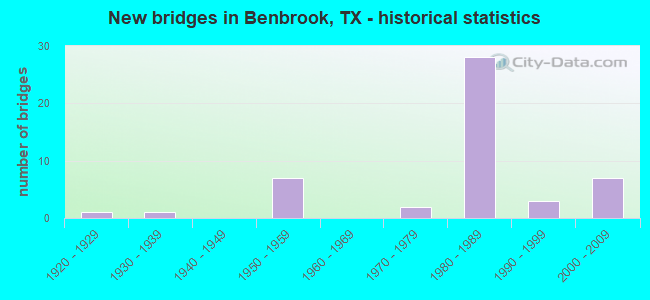
- New bridges - historical statistics
- 11920-1929
- 11930-1939
- 71950-1959
- 21970-1979
- 281980-1989
- 31990-1999
- 72000-2009
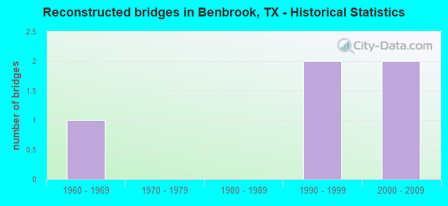
- Reconstructed bridges - Historical Statistics
- 11960-1969
- 01970-1979
- 01980-1989
- 21990-1999
- 22000-2009
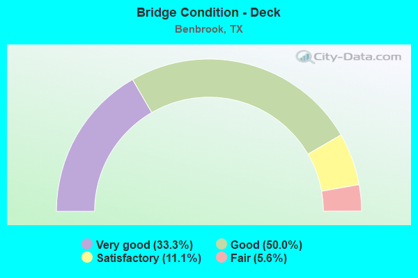
- Bridge Condition - Deck
- 33.3%Very good
- 50.0%Good
- 11.1%Satisfactory
- 5.6%Fair
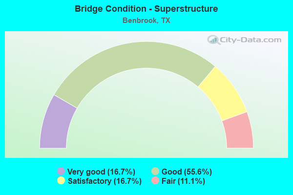
- Bridge Condition - Superstructure
- 16.7%Very good
- 55.6%Good
- 16.7%Satisfactory
- 11.1%Fair
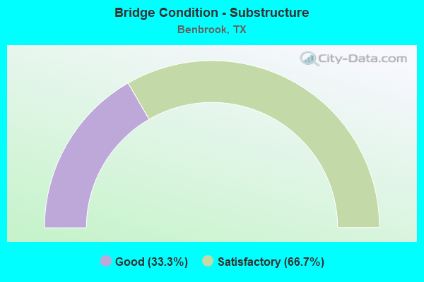
- Bridge Condition - Substructure
- 33.3%Good
- 66.7%Satisfactory
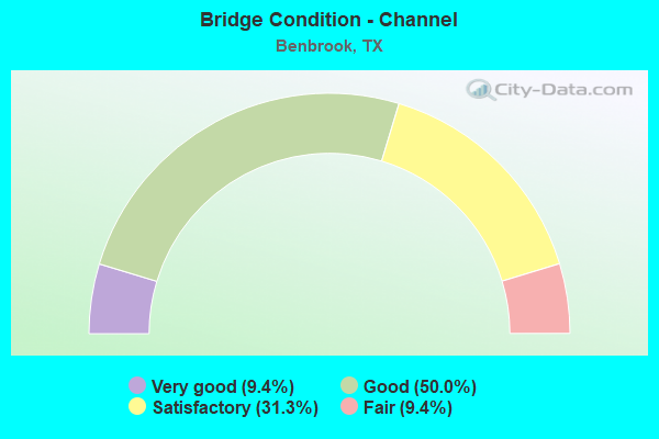
- Bridge Condition - Channel
- 9.4%Very good
- 50.0%Good
- 31.3%Satisfactory
- 9.4%Fair
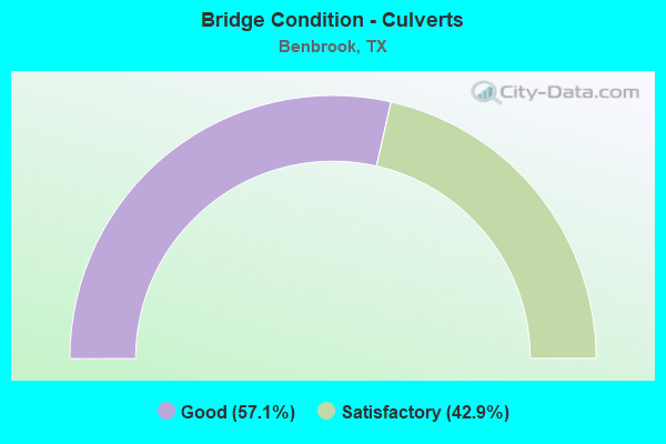
- Bridge Condition - Culverts
- 57.1%Good
- 42.9%Satisfactory
Find on map >> Show street view
Structure Number: 22200000816244, Location: 0.6 MI W OF BRYANT IRVIN (Lat: 32.683758, Lng: -97.425753), Route carried "under" structure: City street , Year Built: 1981, Structure Length: 0. m, Average Daily Traffic: 4,635 (year 2009), Features Intersected: IH 20 EBL, Facility Carried by Structure: IH20 EBL
Minimum Vertical Clearance: 7.77m (25.49ft), Kilometerpoint: 13.897, Lanes on structure: 1, Lanes under structure: 3, Material/Design: Prestressed concrete, Design/Construction: Stringer/Multi-beam, Length of Maximum Span: 41.8m (137.1ft)
Find on map >> Show street view
Structure Number: 22200000816286, Location: 0.4 MI E OF US 377 (Lat: 32.683792, Lng: -97.452436), Route carried "under" structure: Interstate 20, Year Built: 1982, Structure Length: 0. m, Average Daily Traffic: 76,660 (year 2013), Truck Traffic: 1%, Features Intersected: WINSCOTT RD., Facility Carried by Structure: WINSCOTT RD.
Minimum Vertical Clearance: 5.01m (16.44ft), Kilometerpoint: 11.479, Lanes on structure: 4, Lanes under structure: 8, Material/Design: Prestressed concrete, Design/Construction: Stringer/Multi-beam, Length of Maximum Span: 33.5m (109.9ft)
Find on map >> Show street view
Structure Number: 22200000816287, Location: 0.3 MI E OF US 377 (Lat: 32.684564, Lng: -97.454753), Route carried "under" structure: Ramp Interstate 20, Year Built: 1982, Structure Length: 0. m, Average Daily Traffic: 8,400 (year 2013), Truck Traffic: 4%, Features Intersected: North Collector Rd
Minimum Vertical Clearance: 5.13m (16.83ft), Kilometerpoint: 11.204, Lanes on structure: 1, Lanes under structure: 1, Material/Design: Prestressed concrete, Design/Construction: Stringer/Multi-beam, Length of Maximum Span: 23.2m (76.1ft)
Find on map >> Show street view
Structure Number: 22200000816288, Location: 0.2 MI E OF US 377 (Lat: 32.683150, Lng: -97.455028), Route carried "under" structure: Ramp Interstate 20, Year Built: 1982, Structure Length: 0. m, Average Daily Traffic: 8,400 (year 2013), Truck Traffic: 4%, Features Intersected: South Collector Rd
Minimum Vertical Clearance: 5.05m (16.57ft), Kilometerpoint: 11.204, Lanes on structure: 1, Lanes under structure: 1, Material/Design: Prestressed concrete, Design/Construction: Stringer/Multi-beam, Length of Maximum Span: 24.4m (80.1ft)
Find on map >> Show street view
Structure Number: 22200000816289, Location: 0.4 MI W OF WINSCOTT RD. (Lat: 32.684214, Lng: -97.459600), Route carried "under" structure: Interstate 20, Year Built: 1982, Structure Length: 0. m, Average Daily Traffic: 36,350 (year 2013), Truck Traffic: 1%, Features Intersected: US 377, Facility Carried by Structure: US 377
Minimum Vertical Clearance: 5.21m (17.09ft), Kilometerpoint: 10.795, Lanes on structure: 6, Lanes under structure: 10, Material/Design: Prestressed concrete, Design/Construction: Stringer/Multi-beam, Length of Maximum Span: 32.0m (105.0ft)