Bridge Statistics for Bedford, Pennsylvania (PA)
Condition, Traffic, Stress, Structural Evaluation, Project Costs
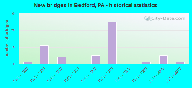
- New bridges - historical statistics
- 11920-1929
- 111930-1939
- 41940-1949
- 51960-1969
- 251970-1979
- 11990-1999
- 52000-2009
- 12010-2019

- Reconstructed bridges - Historical Statistics
- 21980-1989
- 21990-1999
- 162000-2009
- 22010-2019


- Bridge Condition - Deck
- 3.6%Very good
- 57.1%Good
- 25.0%Satisfactory
- 14.3%Fair

- Bridge Condition - Superstructure
- 14.3%Very good
- 14.3%Good
- 42.9%Satisfactory
- 28.6%Fair

- Bridge Condition - Substructure
- 32.1%Good
- 32.1%Satisfactory
- 35.7%Fair

- Bridge Condition - Channel
- 12.5%Good
- 43.8%Satisfactory
- 31.3%Fair
- 12.5%Poor
Find on map >> Show street view
Structure Number: 41, Location: 0.5 MI.W. OF CASHTOWN (Lat: 39.896028, Lng: -77.366719), Route carried "on" structure: US 30, Year Built: 1948, Status: Open, Structure Length: 0.73m (2.40ft), Average Daily Traffic: 9,337 (year 2022), Truck Traffic: 8%, Average Future Daily Traffic: 11,274 (year 2032), Design Load: HS 20, Features Intersected: MARSH CREEK
Minimum Vertical Clearance: 30+ m (98+ ft), Kilometerpoint: 8.874, Lanes on structure: 2, Base Highway Network: Yes, Owner: State Highway Agency, Approaching Roadway Width: 13.7m (44.9ft), Skew: 1 degrees, Material/Design: Concrete, Design/Construction: Tee Beam, Number Of Spans In Main Unit: 1, Length of Maximum Span: 6.7m (22.0ft), Curb or Sidewalk Widths: Left: 0.2m (0.7ft), Right: 0.2m (0.7ft), Curb-To-Curb Width: 15.0m (49.2ft), Out-to-Out Width: 16.0m (52.5ft)
Condition: Deck: Fair, Superstructure: Fair, Substructure: Fair, Channel: Fair, Operating Rating: 60.8 metric tons, Method Used To Determine Operating Rating: Load Factor (LF), Inventory Rating: 36.3 metric tons, Method Used To Determine Inventory Rating: Load Factor (LF), Structural Evaluation: Somewhat better than minimum adequacy, Deck Geometry: Superior to present desirable criteria, Waterway Adequacy: Equal to present minimum criteria, Approach Roadway Alignment: Equal to present desirable criteria, Length Of Structure Improvement: 1.40m (4.59ft), Designated Inspection Frequency: Every 24 months, Inspection Date: Febuary 2021, Bridge Improvement Cost: $26,000, Roadway Improvement Cost: $77,000, Total Project Cost: $351,000, Deck Structure Type: Concrete Cast-file-Place, Wearing Surface/Protective System: Wearing Surface: Bituminous
Find on map >> Show street view
Structure Number: 3968, Location: OVER SR 4009 (Lat: 40.020878, Lng: -78.501947), Route carried "on" structure: US 30, Year Built: 1970, Year Reconstructed: 2007, Status: Open, Structure Length: 1.95m (6.40ft), Average Daily Traffic: 13,085 (year 2020), Truck Traffic: 18%, Average Future Daily Traffic: 18,076 (year 2032), Design Load: HS 20, Features Intersected: BUSINESS 220 (SR 4009)
Minimum Vertical Clearance: 30+ m (98+ ft), Kilometerpoint: 26.067, Lanes on structure: 4, Lanes under structure: 3, Base Highway Network: Yes, Owner: State Highway Agency, Approaching Roadway Width: 21.0m (68.9ft), Skew: 30 degrees, Material/Design: Prestressed concrete, Design/Construction: Box Beam or Girders - Multiple, Number Of Spans In Main Unit: 1, Length of Maximum Span: 18.9m (62.0ft), Curb or Sidewalk Widths: Left: 0.2m (0.7ft), Right: 0.2m (0.7ft), Curb-To-Curb Width: 20.9m (68.6ft), Out-to-Out Width: 23.2m (76.1ft)
Condition: Deck: Satisfactory, Superstructure: Good, Substructure: Good, Operating Rating: 93.4 metric tons, Method Used To Determine Operating Rating: Load Factor (LF), Inventory Rating: 38.1 metric tons, Method Used To Determine Inventory Rating: Load Factor (LF), Structural Evaluation: Better than present minimum criteria, Deck Geometry: Superior to present desirable criteria, Underclear: Better than present minimum criteria, Approach Roadway Alignment: Equal to present desirable criteria, Length Of Structure Improvement: 2.40m (7.87ft), Designated Inspection Frequency: Every 48 months, Inspection Date: April 2020, Bridge Improvement Cost: $101,000, Roadway Improvement Cost: $297,000, Total Project Cost: $1,361,000, Deck Structure Type: Concrete Cast-file-Place, Wearing Surface/Protective System: Wearing Surface: Latex Concrete
Find on map >> Show street view
Structure Number: 397, Location: OVER SR 4010 (Lat: 40.018922, Lng: -78.479694), Route carried "on" structure: US 30, Year Built: 1970, Year Reconstructed: 2007, Status: Open, Structure Length: 10.39m (34.09ft), Average Daily Traffic: 6,449 (year 2020), Truck Traffic: 19%, Average Future Daily Traffic: 8,809 (year 2032), Design Load: HS 20, Features Intersected: SR 4010
Minimum Vertical Clearance: 30+ m (98+ ft), Kilometerpoint: 27.797, Lanes on structure: 2, Lanes under structure: 8, Base Highway Network: Yes, Owner: State Highway Agency, Approaching Roadway Width: 11.6m (38.1ft), Skew: 5 degrees, Material/Design: Prestressed concrete, Design/Construction: Stringer/Multi-beam, Number Of Spans In Main Unit: 4, Length of Maximum Span: 32.0m (105.0ft), Curb or Sidewalk Widths: Left: 0.2m (0.7ft), Right: 0.2m (0.7ft), Curb-To-Curb Width: 10.2m (33.5ft), Out-to-Out Width: 11.4m (37.4ft)
Condition: Deck: Good, Superstructure: Good, Substructure: Fair, Operating Rating: 62.6 metric tons, Method Used To Determine Operating Rating: Load Factor (LF), Inventory Rating: 13.6 metric tons, Method Used To Determine Inventory Rating: Load Factor (LF), Structural Evaluation: High priority of corrective action, Deck Geometry: Somewhat better than minimum adequacy, Underclear: Equal to present minimum criteria, Approach Roadway Alignment: Equal to present desirable criteria, Length Of Structure Improvement: 13.00m (42.65ft), Designated Inspection Frequency: Every 24 months, Inspection Date: April 2020, Bridge Improvement Cost: $315,000, Roadway Improvement Cost: $927,000, Total Project Cost: $4,249,000, Deck Structure Type: Concrete Cast-file-Place, Wearing Surface/Protective System: Wearing Surface: Latex Concrete
Find on map >> Show street view
Structure Number: 3971, Location: 0.6 MILE WEST OF TR 326 (Lat: 40.019867, Lng: -78.480531), Route carried "on" structure: US 30, Year Built: 1970, Year Reconstructed: 2007, Status: Open, Structure Length: 11.49m (37.70ft), Average Daily Traffic: 6,636 (year 2020), Truck Traffic: 17%, Average Future Daily Traffic: 9,267 (year 2032), Design Load: HS 20, Features Intersected: RAYSTOWN BR.JUNIATA RIV.
Minimum Vertical Clearance: 30+ m (98+ ft), Kilometerpoint: 27.846, Lanes on structure: 2, Base Highway Network: Yes, Owner: State Highway Agency, Approaching Roadway Width: 11.6m (38.1ft), Skew: 13 degrees, Material/Design: Prestressed concrete, Design/Construction: Stringer/Multi-beam, Number Of Spans In Main Unit: 4, Length of Maximum Span: 30.8m (101.0ft), Curb or Sidewalk Widths: Left: 0.2m (0.7ft), Right: 0.2m (0.7ft), Curb-To-Curb Width: 10.2m (33.5ft), Out-to-Out Width: 11.4m (37.4ft)
Condition: Deck: Good, Superstructure: Satisfactory, Substructure: Fair, Channel: Fair, Operating Rating: 61.7 metric tons, Method Used To Determine Operating Rating: Load Factor (LF), Inventory Rating: 20.0 metric tons, Method Used To Determine Inventory Rating: Load Factor (LF), Structural Evaluation: Somewhat better than minimum adequacy, Deck Geometry: Somewhat better than minimum adequacy, Waterway Adequacy: Superior to present desirable criteria, Approach Roadway Alignment: Equal to present desirable criteria, Length Of Structure Improvement: 12.40m (40.68ft), Designated Inspection Frequency: Every 24 months, Inspection Date: July 2020, Deck Structure Type: Concrete Cast-file-Place, Wearing Surface/Protective System: Wearing Surface: Latex Concrete
Find on map >> Show street view
Structure Number: 3973, Location: 16 FEET EAST OF TR 326 (Lat: 40.014553, Lng: -78.472153), Route carried "on" structure: US 30, Year Built: 1935, Year Reconstructed: 2006, Status: Open, Structure Length: 18.26m (59.91ft), Average Daily Traffic: 8,842 (year 2020), Truck Traffic: 15%, Average Future Daily Traffic: 12,914 (year 2032), Design Load: H 20, Features Intersected: RAYSTOWN BR.JUNIATA RIV.
Minimum Vertical Clearance: 30+ m (98+ ft), Kilometerpoint: 28.799, Lanes on structure: 3, Base Highway Network: Yes, Owner: State Highway Agency, Approaching Roadway Width: 12.8m (42.0ft), Skew: 4 degrees, Material/Design: Concrete, Design/Construction: Arch - Deck, Number Of Spans In Main Unit: 5, Length of Maximum Span: 36.3m (119.1ft), Curb or Sidewalk Widths: Left: 0.2m (0.7ft), Right: 0.2m (0.7ft), Curb-To-Curb Width: 13.8m (45.3ft), Out-to-Out Width: 14.9m (48.9ft)
Condition: Deck: Good, Superstructure: Fair, Substructure: Satisfactory, Channel: Satisfactory, Operating Rating: 81.6 metric tons, Method Used To Determine Operating Rating: Load Factor (LF), Inventory Rating: 54.4 metric tons, Method Used To Determine Inventory Rating: Load Factor (LF), Structural Evaluation: Somewhat better than minimum adequacy, Deck Geometry: Somewhat better than minimum adequacy, Waterway Adequacy: Superior to present desirable criteria, Approach Roadway Alignment: Equal to present minimum criteria, Length Of Structure Improvement: 22.80m (74.80ft), Designated Inspection Frequency: Every 24 months, Inspection Date: August 2021, Bridge Improvement Cost: $582,000, Roadway Improvement Cost: $1,715,000, Total Project Cost: $7,860,000, Deck Structure Type: Concrete Cast-file-Place, Wearing Surface/Protective System: Wearing Surface: Monolithic Concrete, Deck Protection: Epoxy Coated Reinforcing
Find on map >> Show street view
Structure Number: 4064, Location: 1.9 MI. NORTH OF TURNPIKE (Lat: 40.075586, Lng: -78.523772), Route carried "on" structure: State highway , Year Built: 1971, Year Reconstructed: 2007, Status: Open, Structure Length: 8.66m (28.41ft), Average Daily Traffic: 1,025 (year 2020), Truck Traffic: 11%, Average Future Daily Traffic: 834 (year 2032), Design Load: HS 20, Features Intersected: I-99 / US 220, Facility Carried by Structure: T494 COUNTRY RIDGE
Minimum Vertical Clearance: 30+ m (98+ ft), Kilometerpoint: 0.000, Lanes on structure: 2, Lanes under structure: 4, Owner: State Highway Agency, Approaching Roadway Width: 12.8m (42.0ft), Skew: 1 degrees, Material/Design: Steel continuous, Design/Construction: Stringer/Multi-beam, Number Of Spans In Main Unit: 2, Number Of Approach Spans: 2, Length of Maximum Span: 30.5m (100.1ft), Curb or Sidewalk Widths: Left: 0.2m (0.7ft), Right: 0.2m (0.7ft), Curb-To-Curb Width: 12.8m (42.0ft), Out-to-Out Width: 14.0m (45.9ft)
Condition: Deck: Good, Superstructure: Satisfactory, Substructure: Good, Operating Rating: 54.4 metric tons, Method Used To Determine Operating Rating: Load Factor (LF), Inventory Rating: 32.7 metric tons, Method Used To Determine Inventory Rating: Load Factor (LF), Structural Evaluation: Equal to present minimum criteria, Deck Geometry: Better than present minimum criteria, Underclear: High priority of corrective action, Approach Roadway Alignment: Equal to present desirable criteria, Length Of Structure Improvement: 9.60m (31.50ft), Designated Inspection Frequency: Every 24 months, Inspection Date: April 2020, Bridge Improvement Cost: $22,000, Roadway Improvement Cost: $66,000, Total Project Cost: $302,000, Deck Structure Type: Concrete Cast-file-Place, Wearing Surface/Protective System: Wearing Surface: Epoxy Overlay
Find on map >> Show street view
Structure Number: 41, Location: OVER SR 4010 (Lat: 40.022097, Lng: -78.514825), Route carried "on" structure: US 220, Year Built: 1970, Year Reconstructed: 2006, Status: Open, Structure Length: 1.68m (5.51ft), Average Daily Traffic: 11,350 (year 2020), Truck Traffic: 22%, Average Future Daily Traffic: 12,727 (year 2032), Design Load: HS 20, Features Intersected: SR 4010 (PITT STREET)
Minimum Vertical Clearance: 30+ m (98+ ft), Kilometerpoint: 38.269, Lanes on structure: 3, Lanes under structure: 2, Base Highway Network: Yes, Owner: State Highway Agency, Approaching Roadway Width: 15.8m (51.8ft), Skew: 30 degrees, Material/Design: Prestressed concrete, Design/Construction: Box Beam or Girders - Multiple, Number Of Spans In Main Unit: 1, Length of Maximum Span: 16.2m (53.1ft), Curb or Sidewalk Widths: Left: 0.2m (0.7ft), Right: 0.2m (0.7ft), Curb-To-Curb Width: 15.5m (50.9ft), Out-to-Out Width: 31.5m (103.3ft)
Condition: Deck: Satisfactory, Superstructure: Satisfactory, Substructure: Fair, Operating Rating: 69.9 metric tons, Method Used To Determine Operating Rating: Load Factor (LF), Inventory Rating: 33.6 metric tons, Method Used To Determine Inventory Rating: Load Factor (LF), Structural Evaluation: Somewhat better than minimum adequacy, Deck Geometry: Equal to present minimum criteria, Underclear: Meets minimum limits, Approach Roadway Alignment: Equal to present desirable criteria, Length Of Structure Improvement: 2.10m (6.89ft), Designated Inspection Frequency: Every 24 months, Inspection Date: April 2021, Bridge Improvement Cost: $114,000, Roadway Improvement Cost: $337,000, Total Project Cost: $1,542,000, Deck Structure Type: Concrete Cast-file-Place, Wearing Surface/Protective System: Wearing Surface: Latex Concrete
Find on map >> Show street view
Structure Number: 4104, Location: 0.2 MI. SOUTH OF TURNPIKE (Lat: 40.047106, Lng: -78.516889), Route carried "on" structure: US 220, Year Built: 1971, Year Reconstructed: 2006, Status: Open, Structure Length: 13.11m (43.01ft), Average Daily Traffic: 5,611 (year 2020), Truck Traffic: 23%, Average Future Daily Traffic: 5,950 (year 2032), Design Load: H 20, Features Intersected: T705, JUN.RIV, RR GRADE
Minimum Vertical Clearance: 30+ m (98+ ft), Kilometerpoint: 41.111, Lanes on structure: 2, Lanes under structure: 2, Base Highway Network: Yes, Owner: State Highway Agency, Approaching Roadway Width: 12.2m (40.0ft), Skew: 10 degrees, Material/Design: Steel continuous, Design/Construction: Stringer/Multi-beam, Number Of Spans In Main Unit: 4, Length of Maximum Span: 34.4m (112.9ft), Curb or Sidewalk Widths: Left: 0.2m (0.7ft), Right: 0.2m (0.7ft), Curb-To-Curb Width: 12.2m (40.0ft), Out-to-Out Width: 13.4m (44.0ft)
Condition: Deck: Good, Superstructure: Satisfactory, Substructure: Satisfactory, Channel: Satisfactory, Operating Rating: 49.9 metric tons, Method Used To Determine Operating Rating: Load Factor (LF), Inventory Rating: 29.9 metric tons, Method Used To Determine Inventory Rating: Load Factor (LF), Structural Evaluation: Equal to present minimum criteria, Deck Geometry: Better than present minimum criteria, Underclear: Meets minimum limits, Waterway Adequacy: Superior to present desirable criteria, Approach Roadway Alignment: Equal to present desirable criteria, Length Of Structure Improvement: 16.40m (53.81ft), Designated Inspection Frequency: Every 24 months, Inspection Date: May 2020, Bridge Improvement Cost: $398,000, Roadway Improvement Cost: $1,171,000, Total Project Cost: $5,368,000, Deck Structure Type: Concrete Cast-file-Place, Wearing Surface/Protective System: Wearing Surface: Latex Concrete
Find on map >> Show street view
Structure Number: 4105, Location: OVER PA TURNPIKE (Lat: 40.049897, Lng: -78.517828), Route carried "on" structure: US 220, Year Built: 1971, Year Reconstructed: 2006, Status: Open, Structure Length: 6.10m (20.01ft), Average Daily Traffic: 5,611 (year 2020), Truck Traffic: 23%, Average Future Daily Traffic: 5,950 (year 2032), Design Load: H 20, Features Intersected: I-70/I-76 PA TURNPIKE
Minimum Vertical Clearance: 30+ m (98+ ft), Kilometerpoint: 41.111, Lanes on structure: 2, Lanes under structure: 5, Base Highway Network: Yes, Owner: State Highway Agency, Approaching Roadway Width: 13.4m (44.0ft), Skew: 10 degrees, Material/Design: Steel, Design/Construction: Stringer/Multi-beam, Number Of Spans In Main Unit: 1, Number Of Approach Spans: 2, Length of Maximum Span: 37.2m (122.0ft), Curb or Sidewalk Widths: Left: 0.2m (0.7ft), Right: 0.2m (0.7ft), Curb-To-Curb Width: 12.2m (40.0ft), Out-to-Out Width: 13.4m (44.0ft)
Condition: Deck: Good, Superstructure: Satisfactory, Substructure: Fair, Operating Rating: 68.0 metric tons, Method Used To Determine Operating Rating: Load Factor (LF), Inventory Rating: 40.8 metric tons, Method Used To Determine Inventory Rating: Load Factor (LF), Structural Evaluation: Somewhat better than minimum adequacy, Deck Geometry: Better than present minimum criteria, Underclear: Superior to present desirable criteria, Approach Roadway Alignment: Equal to present desirable criteria, Length Of Structure Improvement: 7.60m (24.93ft), Designated Inspection Frequency: Every 24 months, Inspection Date: September 2020, Bridge Improvement Cost: $114,000, Roadway Improvement Cost: $337,000, Total Project Cost: $1,542,000, Deck Structure Type: Concrete Cast-file-Place, Wearing Surface/Protective System: Wearing Surface: Latex Concrete
Find on map >> Show street view
Structure Number: 4107, Location: OVER PA TURNPIKE (Lat: 40.049892, Lng: -78.518142), Route carried "on" structure: US 220, Year Built: 1971, Year Reconstructed: 2006, Status: Open, Structure Length: 6.10m (20.01ft), Average Daily Traffic: 5,739 (year 2020), Truck Traffic: 21%, Average Future Daily Traffic: 6,777 (year 2032), Design Load: H 20, Features Intersected: I-70/I-76 PA TURNPIKE
Minimum Vertical Clearance: 30+ m (98+ ft), Kilometerpoint: 41.101, Lanes on structure: 2, Lanes under structure: 5, Base Highway Network: Yes, Owner: State Highway Agency, Approaching Roadway Width: 13.4m (44.0ft), Skew: 10 degrees, Material/Design: Steel, Design/Construction: Stringer/Multi-beam, Number Of Spans In Main Unit: 1, Number Of Approach Spans: 2, Length of Maximum Span: 37.2m (122.0ft), Curb or Sidewalk Widths: Left: 0.2m (0.7ft), Right: 0.2m (0.7ft), Curb-To-Curb Width: 12.2m (40.0ft), Out-to-Out Width: 13.4m (44.0ft)
Condition: Deck: Good, Superstructure: Satisfactory, Substructure: Fair, Operating Rating: 68.0 metric tons, Method Used To Determine Operating Rating: Load Factor (LF), Inventory Rating: 40.8 metric tons, Method Used To Determine Inventory Rating: Load Factor (LF), Structural Evaluation: Somewhat better than minimum adequacy, Deck Geometry: Better than present minimum criteria, Underclear: High priority of corrective action, Approach Roadway Alignment: Equal to present desirable criteria, Length Of Structure Improvement: 7.60m (24.93ft), Designated Inspection Frequency: Every 24 months, Inspection Date: September 2020, Bridge Improvement Cost: $114,000, Roadway Improvement Cost: $337,000, Total Project Cost: $1,542,000, Deck Structure Type: Concrete Cast-file-Place, Wearing Surface/Protective System: Wearing Surface: Latex Concrete
Find on map >> Show street view
Structure Number: 4142, Location: 1 MI.E.OF BEDFORD (Lat: 40.024247, Lng: -78.477708), Route carried "on" structure: State highway , Year Built: 1941, Year Reconstructed: 2018, Status: Open, Structure Length: 3.93m (12.89ft), Average Daily Traffic: 671 (year 2022), Truck Traffic: 3%, Average Future Daily Traffic: 5,366 (year 2032), Design Load: HL 93, Features Intersected: DUNNING CREEK, Facility Carried by Structure: SR 1001
Minimum Vertical Clearance: 30+ m (98+ ft), Kilometerpoint: 2.081, Lanes on structure: 2, Owner: State Highway Agency, Approaching Roadway Width: 6.1m (20.0ft), Skew: 3 degrees, Material/Design: Steel continuous, Design/Construction: Stringer/Multi-beam, Number Of Spans In Main Unit: 2, Length of Maximum Span: 19.2m (63.0ft), Curb-To-Curb Width: 8.5m (27.9ft), Out-to-Out Width: 9.1m (29.9ft)
Condition: Deck: Very good, Superstructure: Very good, Substructure: Satisfactory, Channel: Satisfactory, Operating Rating: 42.1 metric tons, Method Used To Determine Operating Rating: Assigned ratings based on Load and Resistance Factor Design (LRFD) reported by rating factor (RF) using HL93 loadings, Inventory Rating: 32.7 metric tons, Method Used To Determine Inventory Rating: Assigned ratings based on Load and Resistance Factor Design (LRFD) reported by rating factor (RF) using HL93 loadings, Structural Evaluation: Equal to present minimum criteria, Deck Geometry: Somewhat better than minimum adequacy, Waterway Adequacy: Better than present minimum criteria, Approach Roadway Alignment: Somewhat better than minimum adequacy, Length Of Structure Improvement: 4.79m (15.72ft), Designated Inspection Frequency: Every 24 months, Inspection Date: September 2020, Bridge Improvement Cost: $117,000, Roadway Improvement Cost: $344,000, Total Project Cost: $1,577,000, Deck Structure Type: Concrete Cast-file-Place, Wearing Surface/Protective System: Wearing Surface: Monolithic Concrete, Deck Protection: Epoxy Coated Reinforcing
Find on map >> Show street view
Structure Number: 418, Location: .1 MI.E.OF BELDEN (Lat: 40.072533, Lng: -78.500169), Route carried "on" structure: State highway , Year Built: 1929, Year Reconstructed: 2009, Status: Open, Structure Length: 0.79m (2.59ft), Average Daily Traffic: 596 (year 2020), Truck Traffic: 4%, Average Future Daily Traffic: 710 (year 2032), Design Load: H 15, Features Intersected: TRIB DUNNING CREEK, Facility Carried by Structure: SR 1014
Minimum Vertical Clearance: 30+ m (98+ ft), Kilometerpoint: 0.705, Lanes on structure: 2, Owner: State Highway Agency, Approaching Roadway Width: 5.5m (18.0ft), Skew: 4 degrees, Material/Design: Steel, Design/Construction: Stringer/Multi-beam, Number Of Spans In Main Unit: 1, Length of Maximum Span: 7.3m (24.0ft), Curb or Sidewalk Widths: Left: 0.2m (0.7ft), Right: 0.2m (0.7ft), Curb-To-Curb Width: 5.2m (17.1ft), Out-to-Out Width: 6.0m (19.7ft)
Condition: Deck: Good, Superstructure: Good, Substructure: Satisfactory, Channel: Poor, Inventory Rating: 63.5 metric tons, Method Used To Determine Inventory Rating: Load Factor (LF), Structural Evaluation: Equal to present minimum criteria, Deck Geometry: High priority of replacement, Waterway Adequacy: Equal to present desirable criteria, Approach Roadway Alignment: Better than present minimum criteria, Length Of Structure Improvement: 1.50m (4.92ft), Designated Inspection Frequency: Every 24 months, Inspection Date: March 2020, Deck Structure Type: Concrete Cast-file-Place, Wearing Surface/Protective System: Wearing Surface: Bituminous, Membrane: Preformed Fabric
Find on map >> Show street view
Structure Number: 4181, Location: 1 MI.E.OF BELDEN (Lat: 40.071369, Lng: -78.491592), Route carried "on" structure: State highway , Year Built: 1961, Year Reconstructed: 2008, Status: Open, Structure Length: 3.54m (11.61ft), Average Daily Traffic: 255 (year 2022), Truck Traffic: 9%, Average Future Daily Traffic: 268 (year 2032), Design Load: HS 20, Features Intersected: DUNNINGS CREEK, Facility Carried by Structure: SR 1014
Minimum Vertical Clearance: 30+ m (98+ ft), Kilometerpoint: 1.550, Lanes on structure: 2, Owner: State Highway Agency, Approaching Roadway Width: 5.5m (18.0ft), Skew: 1 degrees, Material/Design: Prestressed concrete, Design/Construction: Box Beam or Girders - Multiple, Number Of Spans In Main Unit: 2, Length of Maximum Span: 17.4m (57.1ft), Curb-To-Curb Width: 8.4m (27.6ft), Out-to-Out Width: 10.2m (33.5ft)
Condition: Deck: Good, Superstructure: Satisfactory, Substructure: Satisfactory, Channel: Fair, Operating Rating: 87.1 metric tons, Method Used To Determine Operating Rating: Load Factor (LF), Inventory Rating: 27.2 metric tons, Method Used To Determine Inventory Rating: Load Factor (LF), Structural Evaluation: Equal to present minimum criteria, Deck Geometry: Somewhat better than minimum adequacy, Waterway Adequacy: Equal to present desirable criteria, Approach Roadway Alignment: Better than present minimum criteria, Length Of Structure Improvement: 4.40m (14.44ft), Designated Inspection Frequency: Every 24 months, Inspection Date: August 2021, Deck Structure Type: Concrete Cast-file-Place, Wearing Surface/Protective System: Wearing Surface: Monolithic Concrete, Deck Protection: Epoxy Coated Reinforcing
Find on map >> Show street view
Structure Number: 4189, Location: 1.46 MILE E. FROM SR 1014 (Lat: 40.062361, Lng: -78.482569), Route carried "on" structure: State highway , Year Built: 1962, Year Reconstructed: 2009, Status: Open, Structure Length: 4.66m (15.29ft), Average Daily Traffic: 320 (year 2022), Truck Traffic: 2%, Average Future Daily Traffic: 326 (year 2040), Design Load: HS 20, Features Intersected: DUNNING CREEK, Facility Carried by Structure: T493 RABBIT LANE
Minimum Vertical Clearance: 30+ m (98+ ft), Kilometerpoint: 0.006, Lanes on structure: 2, Owner: State Highway Agency, Approaching Roadway Width: 5.5m (18.0ft), Skew: 3 degrees, Material/Design: Prestressed concrete, Design/Construction: Stringer/Multi-beam, Number Of Spans In Main Unit: 2, Length of Maximum Span: 23.2m (76.1ft), Curb-To-Curb Width: 9.0m (29.5ft), Out-to-Out Width: 10.8m (35.4ft)
Condition: Deck: Good, Superstructure: Very good, Substructure: Good, Channel: Poor, Operating Rating: 68.9 metric tons, Method Used To Determine Operating Rating: Load Factor (LF), Inventory Rating: 28.1 metric tons, Method Used To Determine Inventory Rating: Load Factor (LF), Structural Evaluation: Better than present minimum criteria, Deck Geometry: Equal to present minimum criteria, Waterway Adequacy: Equal to present desirable criteria, Approach Roadway Alignment: Better than present minimum criteria, Length Of Structure Improvement: 5.80m (19.03ft), Designated Inspection Frequency: Every 24 months, Inspection Date: October 2021, Deck Structure Type: Concrete Cast-file-Place, Wearing Surface/Protective System: Wearing Surface: Latex Concrete
Find on map >> Show street view
Structure Number: 4334, Location: 1.5 MI.S.OF BEDFORD (Lat: 40.007181, Lng: -78.526569), Route carried "on" structure: State highway , Year Built: 1969, Year Reconstructed: 2010, Status: Open, Structure Length: 9.75m (31.99ft), Average Daily Traffic: 402 (year 2022), Truck Traffic: 5%, Average Future Daily Traffic: 595 (year 2032), Design Load: HS 20, Features Intersected: US 220, Facility Carried by Structure: SR 3021
Minimum Vertical Clearance: 30+ m (98+ ft), Kilometerpoint: 5.718, Lanes on structure: 2, Lanes under structure: 2, Owner: State Highway Agency, Approaching Roadway Width: 12.8m (42.0ft), Skew: 3 degrees, Material/Design: Steel continuous, Design/Construction: Stringer/Multi-beam, Number Of Spans In Main Unit: 2, Number Of Approach Spans: 2, Length of Maximum Span: 33.2m (108.9ft), Curb or Sidewalk Widths: Left: 0.2m (0.7ft), Right: 0.2m (0.7ft), Curb-To-Curb Width: 12.8m (42.0ft), Out-to-Out Width: 14.0m (45.9ft)
Condition: Deck: Satisfactory, Superstructure: Satisfactory, Substructure: Satisfactory, Operating Rating: 58.1 metric tons, Method Used To Determine Operating Rating: Load Factor (LF), Inventory Rating: 34.5 metric tons, Method Used To Determine Inventory Rating: Load Factor (LF), Structural Evaluation: Equal to present minimum criteria, Deck Geometry: Superior to present desirable criteria, Underclear: Superior to present desirable criteria, Approach Roadway Alignment: Equal to present desirable criteria, Length Of Structure Improvement: 12.19m (39.99ft), Designated Inspection Frequency: Every 24 months, Inspection Date: May 2020, Bridge Improvement Cost: $213,000, Roadway Improvement Cost: $627,000, Total Project Cost: $2,874,000, Deck Structure Type: Concrete Cast-file-Place, Wearing Surface/Protective System: Wearing Surface: Latex Concrete
Find on map >> Show street view
Structure Number: 4344, Location: BEDFORD (Lat: 40.020453, Lng: -78.501917), Route carried "on" structure: Business US 220B, Year Built: 1997, Year Reconstructed: 2012, Status: Open, Structure Length: 5.91m (19.39ft), Average Daily Traffic: 6,422 (year 2020), Truck Traffic: 9%, Average Future Daily Traffic: 9,833 (year 2032), Design Load: HS 25 or greater, Features Intersected: RAYSTOWN BR JUNIATA RIV, Facility Carried by Structure: SR 4009 (BUS 220)
Minimum Vertical Clearance: 30+ m (98+ ft), Kilometerpoint: 9.455, Lanes on structure: 3, Owner: State Highway Agency, Approaching Roadway Width: 12.2m (40.0ft), Material/Design: Prestressed concrete, Design/Construction: Box Beam or Girders - Single/Spread, Number Of Spans In Main Unit: 3, Length of Maximum Span: 18.9m (62.0ft), Curb or Sidewalk Widths: Left: 3.0m (9.8ft), Right: 3.0m (9.8ft), Curb-To-Curb Width: 12.2m (40.0ft), Out-to-Out Width: 18.9m (62.0ft)
Condition: Deck: Satisfactory, Superstructure: Satisfactory, Substructure: Good, Channel: Satisfactory, Operating Rating: 83.5 metric tons, Method Used To Determine Operating Rating: Load Factor (LF), Inventory Rating: 44.5 metric tons, Method Used To Determine Inventory Rating: Load Factor (LF), Structural Evaluation: Equal to present minimum criteria, Deck Geometry: Meets minimum limits, Waterway Adequacy: Equal to present minimum criteria, Approach Roadway Alignment: Equal to present desirable criteria, Length Of Structure Improvement: 6.90m (22.64ft), Designated Inspection Frequency: Every 48 months, Inspection Date: April 2020, Deck Structure Type: Concrete Cast-file-Place, Wearing Surface/Protective System: Wearing Surface: Epoxy Overlay, Deck Protection: Epoxy Coated Reinforcing
Find on map >> Show street view
Structure Number: 4351, Location: 0.1 MILE EAST OF SR 3021 (Lat: 40.019628, Lng: -78.509481), Route carried "on" structure: State highway , Year Built: 1961, Year Reconstructed: 2007, Status: Open, Structure Length: 1.37m (4.49ft), Average Daily Traffic: 8,540 (year 2020), Truck Traffic: 6%, Average Future Daily Traffic: 8,539 (year 2040), Design Load: HS 20, Features Intersected: CUMBERLAND VALLEY RUN, Facility Carried by Structure: SR 4010 (PITT ST.)
Minimum Vertical Clearance: 30+ m (98+ ft), Kilometerpoint: 2.245, Lanes on structure: 2, Owner: State Highway Agency, Approaching Roadway Width: 12.2m (40.0ft), Skew: 1 degrees, Material/Design: Prestressed concrete, Design/Construction: Box Beam or Girders - Multiple, Number Of Spans In Main Unit: 1, Length of Maximum Span: 13.4m (44.0ft), Curb or Sidewalk Widths: Left: 1.5m (4.9ft), Right: 1.5m (4.9ft), Curb-To-Curb Width: 12.2m (40.0ft), Out-to-Out Width: 16.0m (52.5ft)
Condition: Deck: Good, Superstructure: Fair, Substructure: Satisfactory, Channel: Satisfactory, Operating Rating: 78.0 metric tons, Method Used To Determine Operating Rating: Load Factor (LF), Inventory Rating: 28.1 metric tons, Method Used To Determine Inventory Rating: Load Factor (LF), Structural Evaluation: Somewhat better than minimum adequacy, Deck Geometry: Somewhat better than minimum adequacy, Waterway Adequacy: Better than present minimum criteria, Approach Roadway Alignment: Equal to present desirable criteria, Length Of Structure Improvement: 2.10m (6.89ft), Designated Inspection Frequency: Every 24 months, Inspection Date: December 2021, Bridge Improvement Cost: $49,000, Roadway Improvement Cost: $145,000, Total Project Cost: $664,000, Deck Structure Type: Concrete Cast-file-Place, Wearing Surface/Protective System: Wearing Surface: Monolithic Concrete, Deck Protection: Galvanized Reinforcing
Find on map >> Show street view
Structure Number: 4352, Location: 0.59 MILE WEST FROM US 30 (Lat: 40.017192, Lng: -78.485894), Route carried "on" structure: State highway , Year Built: 1936, Year Reconstructed: 2008, Status: Open, Structure Length: 1.74m (5.71ft), Average Daily Traffic: 7,108 (year 2020), Truck Traffic: 8%, Average Future Daily Traffic: 12,098 (year 2032), Design Load: HS 15, Features Intersected: SHOBERS RUN, Facility Carried by Structure: SR 4010
Minimum Vertical Clearance: 30+ m (98+ ft), Kilometerpoint: 4.038, Lanes on structure: 4, Owner: State Highway Agency, Approaching Roadway Width: 24.4m (80.1ft), Skew: 3 degrees, Material/Design: Concrete, Design/Construction: Arch - Deck, Number Of Spans In Main Unit: 1, Length of Maximum Span: 16.8m (55.1ft), Curb or Sidewalk Widths: Left: 0.2m (0.7ft), Right: 0.2m (0.7ft), Curb-To-Curb Width: 23.8m (78.1ft), Out-to-Out Width: 25.0m (82.0ft)
Condition: Deck: Fair, Superstructure: Fair, Substructure: Fair, Channel: Fair, Operating Rating: 82.6 metric tons, Method Used To Determine Operating Rating: Load Factor (LF), Inventory Rating: 38.1 metric tons, Method Used To Determine Inventory Rating: Load Factor (LF), Structural Evaluation: Somewhat better than minimum adequacy, Deck Geometry: Superior to present desirable criteria, Waterway Adequacy: Equal to present desirable criteria, Approach Roadway Alignment: Equal to present desirable criteria, Length Of Structure Improvement: 1.70m (5.58ft), Designated Inspection Frequency: Every 24 months, Inspection Date: November 2021, Deck Structure Type: Other, Wearing Surface/Protective System: Wearing Surface: Monolithic Concrete
Find on map >> Show street view
Structure Number: 4423, Location: BEDFORD INTERCHANGE (Lat: 40.050000, Lng: -78.515000), Route carried "on" structure: Interstate 76, Year Built: 1939, Status: Open, Structure Length: 1.49m (4.89ft), Average Daily Traffic: 30,600 (year 2004), Truck Traffic: 35%, Average Future Daily Traffic: 34,792 (year 2030), Design Load: HS 20, Features Intersected: RAMPS
Minimum Vertical Clearance: 30+ m (98+ ft), Kilometerpoint: 0.000, Lanes on structure: 5, Lanes under structure: 2, Base Highway Network: Yes, Toll: On toll road, Owner: State Toll Authority, Approaching Roadway Width: 33.8m (110.9ft), Skew: 36 degrees, Material/Design: Concrete, Design/Construction: Frame, Number Of Spans In Main Unit: 1, Length of Maximum Span: 12.8m (42.0ft), Curb or Sidewalk Widths: Left: 0.2m (0.7ft), Right: 0.2m (0.7ft), Curb-To-Curb Width: 28.6m (93.8ft), Out-to-Out Width: 30.4m (99.7ft)
Condition: Deck: Fair, Superstructure: Fair, Substructure: Fair, Operating Rating: 93.4 metric tons, Method Used To Determine Operating Rating: Load Factor (LF), Inventory Rating: 56.2 metric tons, Method Used To Determine Inventory Rating: Load Factor (LF), Structural Evaluation: Somewhat better than minimum adequacy, Deck Geometry: Superior to present desirable criteria, Underclear: High priority of corrective action, Approach Roadway Alignment: Equal to present desirable criteria, Length Of Structure Improvement: 2.20m (7.22ft), Designated Inspection Frequency: Every 24 months, Inspection Date: September 2020, Bridge Improvement Cost: $71,000, Roadway Improvement Cost: $210,000, Total Project Cost: $963,000, Wearing Surface/Protective System: Wearing Surface: Bituminous
Find on map >> Show street view
Structure Number: 4424, Location: BEDFORD INTERCHANGE (Lat: 40.036667, Lng: -78.501667), Route carried "on" structure: Interstate 76, Year Built: 1939, Year Reconstructed: 1993, Status: Open, Structure Length: 2.16m (7.09ft), Average Daily Traffic: 30,600 (year 2004), Truck Traffic: 35%, Average Future Daily Traffic: 33,600 (year 2012), Design Load: HS 20, Features Intersected: SR 4009 (LR 47)
Minimum Vertical Clearance: 30+ m (98+ ft), Kilometerpoint: 0.000, Lanes on structure: 6, Lanes under structure: 2, Base Highway Network: Yes, Toll: On toll road, Owner: State Toll Authority, Approaching Roadway Width: 31.7m (104.0ft), Skew: 34 degrees, Material/Design: Steel, Design/Construction: Stringer/Multi-beam, Number Of Spans In Main Unit: 1, Length of Maximum Span: 20.7m (67.9ft), Curb or Sidewalk Widths: Left: 0.2m (0.7ft), Right: 0.2m (0.7ft), Curb-To-Curb Width: 31.7m (104.0ft), Out-to-Out Width: 33.4m (109.6ft)
Condition: Deck: Fair, Superstructure: Fair, Substructure: Fair, Operating Rating: 59.0 metric tons, Method Used To Determine Operating Rating: Load Factor (LF), Inventory Rating: 35.4 metric tons, Method Used To Determine Inventory Rating: Load Factor (LF), Structural Evaluation: Somewhat better than minimum adequacy, Deck Geometry: Superior to present desirable criteria, Underclear: High priority of corrective action, Approach Roadway Alignment: Equal to present desirable criteria, Length Of Structure Improvement: 2.80m (9.19ft), Designated Inspection Frequency: Every 24 months, Inspection Date: September 2020, Bridge Improvement Cost: $63,000, Roadway Improvement Cost: $187,000, Total Project Cost: $855,000, Deck Structure Type: Concrete Cast-file-Place, Wearing Surface/Protective System: Wearing Surface: Bituminous
Find on map >> Show street view
Structure Number: 4425, Location: NEAR BEDFORD (Lat: 40.038353, Lng: -78.501875), Route carried "on" structure: City street , Year Built: 1939, Year Reconstructed: 1988, Status: Open, Structure Length: 2.77m (9.09ft), Average Daily Traffic: 200 (year 1992), Truck Traffic: 9%, Average Future Daily Traffic: 315 (year 2030), Design Load: HS 20, Features Intersected: PA TPK (I-76), Facility Carried by Structure: T-478
Minimum Vertical Clearance: 30+ m (98+ ft), Kilometerpoint: 0.000, Lanes on structure: 2, Lanes under structure: 4, Owner: State Toll Authority, Approaching Roadway Width: 6.1m (20.0ft), Skew: 2 degrees, Material/Design: Steel, Design/Construction: Girder and Floorbeam System, Number Of Spans In Main Unit: 1, Length of Maximum Span: 26.5m (86.9ft), Curb or Sidewalk Widths: Left: 0.3m (1.0ft), Right: 0.3m (1.0ft), Curb-To-Curb Width: 6.1m (20.0ft), Out-to-Out Width: 7.7m (25.3ft)
Condition: Deck: Good, Superstructure: Satisfactory, Substructure: Good, Operating Rating: 51.7 metric tons, Method Used To Determine Operating Rating: Load Factor (LF), Inventory Rating: 30.8 metric tons, Method Used To Determine Inventory Rating: Load Factor (LF), Structural Evaluation: Equal to present minimum criteria, Deck Geometry: Meets minimum limits, Underclear: High priority of corrective action, Approach Roadway Alignment: Equal to present minimum criteria, Length Of Structure Improvement: 3.50m (11.48ft), Designated Inspection Frequency: Every 24 months, Critical Feature Inspection Frequency: Every 24 months, Inspection Date: September 2020, Critical Feature Inspection Date: September 2020, Deck Structure Type: Concrete Cast-file-Place, Wearing Surface/Protective System: Wearing Surface: Latex Concrete
Find on map >> Show street view
Structure Number: 4427, Location: EAST OF BEDFORD (Lat: 40.017628, Lng: -78.473461), Route carried "on" structure: Interstate 70, Year Built: 1939, Year Reconstructed: 1997, Status: Open, Structure Length: 14.81m (48.59ft), Average Daily Traffic: 36,252 (year 2004), Truck Traffic: 33%, Average Future Daily Traffic: 40,900 (year 2030), Design Load: HS 20+Mod, Features Intersected: T-477, DUNNINGS CR., Facility Carried by Structure: PA TPK (I-76)
Minimum Vertical Clearance: 30+ m (98+ ft), Kilometerpoint: 0.000, Lanes on structure: 4, Lanes under structure: 2, Base Highway Network: Yes, Toll: On toll road, Owner: State Toll Authority, Approaching Roadway Width: 24.4m (80.1ft), Skew: 35 degrees, Material/Design: Steel, Design/Construction: Girder and Floorbeam System, Number Of Spans In Main Unit: 6, Length of Maximum Span: 29.3m (96.1ft), Curb or Sidewalk Widths: Left: 0.2m (0.7ft), Right: 0.2m (0.7ft), Curb-To-Curb Width: 25.8m (84.6ft), Out-to-Out Width: 27.5m (90.2ft)
Condition: Deck: Good, Superstructure: Fair, Substructure: Satisfactory, Channel: Good, Operating Rating: 53.5 metric tons, Method Used To Determine Operating Rating: Load Factor (LF), Inventory Rating: 31.8 metric tons, Method Used To Determine Inventory Rating: Load Factor (LF), Structural Evaluation: Somewhat better than minimum adequacy, Deck Geometry: Superior to present desirable criteria, Underclear: High priority of corrective action, Waterway Adequacy: Superior to present desirable criteria, Approach Roadway Alignment: Equal to present desirable criteria, Length Of Structure Improvement: 15.80m (51.84ft), Designated Inspection Frequency: Every 24 months, Critical Feature Inspection Frequency: Every 24 months, Underwater Inspection Frequency: Every 60 months, Inspection Date: August 2020, Critical Feature Inspection Date: August 2020, Underwater Inspection Date: September 2018, Bridge Improvement Cost: $377,000, Roadway Improvement Cost: $1,109,000, Total Project Cost: $5,085,000, Deck Structure Type: Concrete Cast-file-Place, Wearing Surface/Protective System: Wearing Surface: Latex Concrete
Find on map >> Show street view
Structure Number: 4429, Location: NEAR HARTLEY (Lat: 40.011836, Lng: -78.465278), Route carried "on" structure: Interstate 76, Year Built: 1940, Year Reconstructed: 1997, Status: Open, Structure Length: 17.50m (57.41ft), Average Daily Traffic: 36,252 (year 2004), Truck Traffic: 33%, Average Future Daily Traffic: 40,900 (year 2030), Design Load: HS 20+Mod, Features Intersected: T-446, BR.JUNIATA
Minimum Vertical Clearance: 30+ m (98+ ft), Kilometerpoint: 0.000, Lanes on structure: 4, Lanes under structure: 2, Base Highway Network: Yes, Toll: On toll road, Owner: State Toll Authority, Approaching Roadway Width: 24.4m (80.1ft), Skew: 30 degrees, Material/Design: Steel continuous, Design/Construction: Girder and Floorbeam System, Number Of Spans In Main Unit: 3, Number Of Approach Spans: 3, Length of Maximum Span: 38.1m (125.0ft), Curb or Sidewalk Widths: Left: 0.2m (0.7ft), Right: 0.2m (0.7ft), Curb-To-Curb Width: 26.1m (85.6ft), Out-to-Out Width: 27.7m (90.9ft)
Condition: Deck: Satisfactory, Superstructure: Fair, Substructure: Satisfactory, Channel: Fair, Operating Rating: 77.1 metric tons, Method Used To Determine Operating Rating: Load Factor (LF), Inventory Rating: 46.3 metric tons, Method Used To Determine Inventory Rating: Load Factor (LF), Structural Evaluation: Somewhat better than minimum adequacy, Deck Geometry: Superior to present desirable criteria, Underclear: Superior to present desirable criteria, Waterway Adequacy: Superior to present desirable criteria, Approach Roadway Alignment: Equal to present desirable criteria, Length Of Structure Improvement: 18.80m (61.68ft), Designated Inspection Frequency: Every 24 months, Critical Feature Inspection Frequency: Every 24 months, Underwater Inspection Frequency: Every 60 months, Inspection Date: August 2020, Critical Feature Inspection Date: August 2020, Underwater Inspection Date: September 2018, Bridge Improvement Cost: $367,000, Roadway Improvement Cost: $1,081,000, Total Project Cost: $4,955,000, Deck Structure Type: Concrete Cast-file-Place, Wearing Surface/Protective System: Wearing Surface: Latex Concrete
Find on map >> Show street view
Structure Number: 4563, Location: TURNPIKE INTERCHANGE (Lat: 40.055975, Lng: -78.518481), Route carried "on" structure: Ramp State highway , Year Built: 1970, Year Reconstructed: 2008, Status: Open, Structure Length: 7.86m (25.79ft), Average Daily Traffic: 3,347 (year 2021), Truck Traffic: 7%, Average Future Daily Traffic: 5,050 (year 2032), Design Load: HS 25 or greater, Features Intersected: I-99 / US 220, Facility Carried by Structure: SR 8007 (EXIT 1)
Minimum Vertical Clearance: 30+ m (98+ ft), Kilometerpoint: 0.000, Lanes on structure: 2, Lanes under structure: 8, Base Highway Network: Yes, Owner: State Highway Agency, Approaching Roadway Width: 22.6m (74.1ft), Skew: 30 degrees, Material/Design: Prestressed concrete, Design/Construction: Box Beam or Girders - Single/Spread, Number Of Spans In Main Unit: 4, Length of Maximum Span: 25.6m (84.0ft), Curb or Sidewalk Widths: Left: 0.1m (0.3ft), Right: 0.1m (0.3ft), Curb-To-Curb Width: 21.1m (69.2ft), Out-to-Out Width: 23.2m (76.1ft)
Condition: Deck: Satisfactory, Superstructure: Satisfactory, Substructure: Fair, Operating Rating: 59.9 metric tons, Method Used To Determine Operating Rating: Load Factor (LF), Inventory Rating: 35.4 metric tons, Method Used To Determine Inventory Rating: Load Factor (LF), Structural Evaluation: Somewhat better than minimum adequacy, Deck Geometry: Superior to present desirable criteria, Underclear: Better than present minimum criteria, Approach Roadway Alignment: Equal to present desirable criteria, Length Of Structure Improvement: 9.80m (32.15ft), Designated Inspection Frequency: Every 24 months, Inspection Date: May 2021, Bridge Improvement Cost: $237,000, Roadway Improvement Cost: $697,000, Total Project Cost: $3,195,000, Deck Structure Type: Concrete Cast-file-Place, Wearing Surface/Protective System: Wearing Surface: Monolithic Concrete, Deck Protection: Epoxy Coated Reinforcing
Find on map >> Show street view
Structure Number: 42427, Location: 16'EAST OF PA 326 (Lat: 40.014361, Lng: -78.471983), Route carried "on" structure: US 30, Year Built: 2004, Status: Open, Structure Length: 17.10m (56.10ft), Average Daily Traffic: 8,966 (year 2020), Truck Traffic: 15%, Average Future Daily Traffic: 12,782 (year 2032), Design Load: HL 93, Features Intersected: RAYSTOWN BR JUNIATI RIV
Minimum Vertical Clearance: 30+ m (98+ ft), Kilometerpoint: 28.788, Lanes on structure: 2, Base Highway Network: Yes, Owner: State Highway Agency, Approaching Roadway Width: 12.5m (41.0ft), Skew: 11 degrees, Material/Design: Prestressed concrete, Design/Construction: Stringer/Multi-beam, Number Of Spans In Main Unit: 5, Length of Maximum Span: 36.0m (118.1ft), Curb or Sidewalk Widths: Left: 0.2m (0.7ft), Right: 0.2m (0.7ft), Curb-To-Curb Width: 12.6m (41.3ft), Out-to-Out Width: 13.5m (44.3ft)
Condition: Deck: Good, Superstructure: Satisfactory, Substructure: Good, Channel: Good, Operating Rating: 79.8 metric tons, Method Used To Determine Operating Rating: Load and Resistance Factor (LRFR), Inventory Rating: 40.8 metric tons, Method Used To Determine Inventory Rating: Load and Resistance Factor (LRFR), Structural Evaluation: Equal to present minimum criteria, Deck Geometry: Better than present minimum criteria, Waterway Adequacy: Superior to present desirable criteria, Approach Roadway Alignment: Better than present minimum criteria, Designated Inspection Frequency: Every 48 months, Inspection Date: July 2019, Deck Structure Type: Concrete Cast-file-Place, Wearing Surface/Protective System: Wearing Surface: Monolithic Concrete, Deck Protection: Epoxy Coated Reinforcing
Find on map >> Show street view
Structure Number: 42977, Location: WOLFSBURG (Lat: 40.046356, Lng: -78.529442), Route carried "on" structure: US 30, Year Built: 2005, Status: Open, Structure Length: 4.97m (16.31ft), Average Daily Traffic: 6,756 (year 2020), Truck Traffic: 11%, Average Future Daily Traffic: 6,622 (year 2032), Design Load: HL 93, Features Intersected: RAYSTOWN BR.JUNIATA RIV.
Minimum Vertical Clearance: 30+ m (98+ ft), Kilometerpoint: 22.128, Lanes on structure: 2, Base Highway Network: Yes, Owner: State Highway Agency, Approaching Roadway Width: 12.2m (40.0ft), Material/Design: Prestressed concrete, Design/Construction: Box Beam or Girders - Single/Spread, Number Of Spans In Main Unit: 2, Length of Maximum Span: 24.4m (80.1ft), Curb or Sidewalk Widths: Left: 0.2m (0.7ft), Right: 2.2m (7.2ft), Curb-To-Curb Width: 12.2m (40.0ft), Out-to-Out Width: 15.2m (49.9ft)
Condition: Deck: Good, Superstructure: Good, Substructure: Good, Channel: Satisfactory, Operating Rating: 66.2 metric tons, Method Used To Determine Operating Rating: Load and Resistance Factor (LRFR), Inventory Rating: 40.8 metric tons, Method Used To Determine Inventory Rating: Load and Resistance Factor (LRFR), Structural Evaluation: Better than present minimum criteria, Deck Geometry: Somewhat better than minimum adequacy, Waterway Adequacy: Equal to present minimum criteria, Approach Roadway Alignment: Equal to present desirable criteria, Length Of Structure Improvement: 5.90m (19.36ft), Designated Inspection Frequency: Every 48 months, Inspection Date: May 2020, Deck Structure Type: Concrete Cast-file-Place, Wearing Surface/Protective System: Wearing Surface: Monolithic Concrete, Deck Protection: Epoxy Coated Reinforcing
Find on map >> Show street view
Structure Number: 45689, Location: OVER US 30 (Lat: 40.012719, Lng: -78.467875), Route carried "on" structure: Interstate 76, Year Built: 2004, Status: Open, Structure Length: 4.11m (13.48ft), Average Daily Traffic: 36,252 (year 2004), Truck Traffic: 33%, Average Future Daily Traffic: 40,900 (year 2030), Design Load: HL 93, Features Intersected: SR 0030
Minimum Vertical Clearance: 30+ m (98+ ft), Kilometerpoint: 0.000, Lanes on structure: 2, Lanes under structure: 4, Base Highway Network: Yes, Toll: On toll road, Owner: State Toll Authority, Approaching Roadway Width: 12.2m (40.0ft), Skew: 32 degrees, Material/Design: Prestressed concrete continuous, Design/Construction: Box Beam or Girders - Single/Spread, Number Of Spans In Main Unit: 2, Length of Maximum Span: 20.7m (67.9ft), Curb or Sidewalk Widths: Left: 0.2m (0.7ft), Right: 0.2m (0.7ft), Curb-To-Curb Width: 12.3m (40.4ft), Out-to-Out Width: 28.0m (91.9ft)
Condition: Deck: Satisfactory, Superstructure: Very good, Substructure: Good, Operating Rating: 80.7 metric tons, Method Used To Determine Operating Rating: Load and Resistance Factor (LRFR), Inventory Rating: 31.8 metric tons, Method Used To Determine Inventory Rating: Load and Resistance Factor (LRFR), Structural Evaluation: Better than present minimum criteria, Deck Geometry: Better than present minimum criteria, Underclear: Equal to present minimum criteria, Approach Roadway Alignment: Equal to present desirable criteria, Designated Inspection Frequency: Every 24 months, Inspection Date: November 2019, Deck Structure Type: Concrete Cast-file-Place, Wearing Surface/Protective System: Wearing Surface: Latex Concrete, Deck Protection: Epoxy Coated Reinforcing
Find on map >> Show street view
Structure Number: 46298, Location: BEDFORD BOROUGH (Lat: 40.013989, Lng: -78.494633), Route carried "on" structure: City street , Year Built: 2010, Status: Open, Structure Length: 1.68m (5.51ft), Average Daily Traffic: 1,369 (year 2020), Truck Traffic: 9%, Average Future Daily Traffic: 1,711 (year 2040), Design Load: HL 93, Features Intersected: SHOBERS RUN, Facility Carried by Structure: WATSON STREET
Minimum Vertical Clearance: 30+ m (98+ ft), Kilometerpoint: 0.000, Lanes on structure: 2, Owner: City or Municipal Highway Agency, Approaching Roadway Width: 8.5m (27.9ft), Material/Design: Prestressed concrete, Design/Construction: Box Beam or Girders - Single/Spread, Number Of Spans In Main Unit: 1, Length of Maximum Span: 16.5m (54.1ft), Curb or Sidewalk Widths: Left: 0.2m (0.7ft), Right: 2.0m (6.6ft), Curb-To-Curb Width: 8.5m (27.9ft), Out-to-Out Width: 11.4m (37.4ft)
Condition: Deck: Good, Superstructure: Very good, Substructure: Good, Channel: Satisfactory, Operating Rating: 61.7 metric tons, Method Used To Determine Operating Rating: Load and Resistance Factor (LRFR), Inventory Rating: 40.8 metric tons, Method Used To Determine Inventory Rating: Load and Resistance Factor (LRFR), Structural Evaluation: Better than present minimum criteria, Deck Geometry: Somewhat better than minimum adequacy, Waterway Adequacy: Equal to present desirable criteria, Approach Roadway Alignment: Equal to present desirable criteria, Designated Inspection Frequency: Every 24 months, Inspection Date: December 2020, Deck Structure Type: Concrete Cast-file-Place, Wearing Surface/Protective System: Wearing Surface: Monolithic Concrete, Deck Protection: Epoxy Coated Reinforcing
Find on map >> Show street view
Structure Number: 3963, Location: OVER US 220 (Lat: 40.025931, Lng: -78.513558), Route carried "under" structure: US 220, Year Built: 1970, Structure Length: 0. m, Average Daily Traffic: 5,611 (year 2020), Truck Traffic: 23%, Features Intersected: US 220, Facility Carried by Structure: US 30
Minimum Vertical Clearance: 4.91m (16.11ft), Kilometerpoint: 38.727, Lanes on structure: 3, Lanes under structure: 3, Material/Design: Prestressed concrete, Design/Construction: Box Beam or Girders - Single/Spread, Length of Maximum Span: 21.3m (69.9ft)
Find on map >> Show street view
Structure Number: 3963, Location: OVER US 220 (Lat: 40.025931, Lng: -78.513558), Route carried "under" structure: US 220, Year Built: 1970, Structure Length: 0. m, Average Daily Traffic: 5,739 (year 2020), Truck Traffic: 21%, Features Intersected: US 220, Facility Carried by Structure: US 30
Minimum Vertical Clearance: 5.59m (18.34ft), Kilometerpoint: 38.726, Lanes on structure: 3, Lanes under structure: 3, Material/Design: Prestressed concrete, Design/Construction: Box Beam or Girders - Single/Spread, Length of Maximum Span: 21.3m (69.9ft)
Find on map >> Show street view
Structure Number: 3968, Location: OVER SR 4009 (Lat: 40.020878, Lng: -78.501947), Route carried "under" structure: Business US 220B, Year Built: 1970, Structure Length: 0. m, Average Daily Traffic: 6,422 (year 2020), Truck Traffic: 9%, Features Intersected: BUSINESS 220 (SR 4009), Facility Carried by Structure: US 30
Minimum Vertical Clearance: 4.88m (16.01ft), Kilometerpoint: 9.455, Lanes on structure: 4, Lanes under structure: 3, Material/Design: Prestressed concrete, Design/Construction: Box Beam or Girders - Multiple, Length of Maximum Span: 18.9m (62.0ft)
Find on map >> Show street view
Structure Number: 397, Location: OVER SR 4010 (Lat: 40.018922, Lng: -78.479694), Route carried "under" structure: State highway , Year Built: 1970, Structure Length: 0. m, Average Daily Traffic: 3,583 (year 2020), Truck Traffic: 9%, Features Intersected: SR 4010, Facility Carried by Structure: US 30 EBL
Minimum Vertical Clearance: 5.18m (16.99ft), Kilometerpoint: 5.087, Lanes on structure: 2, Lanes under structure: 4, Material/Design: Prestressed concrete, Design/Construction: Stringer/Multi-beam, Length of Maximum Span: 32.0m (105.0ft)
Find on map >> Show street view
Structure Number: 397, Location: OVER SR 4010 (Lat: 40.018922, Lng: -78.479694), Route carried "under" structure: State highway , Year Built: 1970, Structure Length: 0. m, Average Daily Traffic: 3,525 (year 2020), Truck Traffic: 8%, Features Intersected: SR 4010, Facility Carried by Structure: US 30 EBL
Minimum Vertical Clearance: 4.75m (15.58ft), Kilometerpoint: 5.066, Lanes on structure: 2, Lanes under structure: 4, Material/Design: Prestressed concrete, Design/Construction: Stringer/Multi-beam, Length of Maximum Span: 32.0m (105.0ft)
Find on map >> Show street view
Structure Number: 4064, Location: 1.9 MI. NORTH OF TURNPIKE (Lat: 40.075586, Lng: -78.523772), Route carried "under" structure: Interstate 99, Year Built: 1971, Structure Length: 0. m, Average Daily Traffic: 5,357 (year 2020), Truck Traffic: 20%, Features Intersected: I-99 / US 220, Facility Carried by Structure: T494 COUNTRY RIDGE
Minimum Vertical Clearance: 5.03m (16.50ft), Kilometerpoint: 1.609, Lanes on structure: 2, Lanes under structure: 2, Material/Design: Steel continuous, Design/Construction: Stringer/Multi-beam, Length of Maximum Span: 30.5m (100.1ft)
Find on map >> Show street view
Structure Number: 4064, Location: 1.9 MI. NORTH OF TURNPIKE (Lat: 40.075586, Lng: -78.523772), Route carried "under" structure: Interstate 99, Year Built: 1971, Structure Length: 0. m, Average Daily Traffic: 5,618 (year 2020), Truck Traffic: 20%, Features Intersected: I-99 / US 220, Facility Carried by Structure: T494 COUNTRY RIDGE
Minimum Vertical Clearance: 5.31m (17.42ft), Kilometerpoint: 1.592, Lanes on structure: 2, Lanes under structure: 2, Material/Design: Steel continuous, Design/Construction: Stringer/Multi-beam, Length of Maximum Span: 30.5m (100.1ft)
Find on map >> Show street view
Structure Number: 41, Location: OVER SR 4010 (Lat: 40.022097, Lng: -78.514825), Route carried "under" structure: State highway , Year Built: 1970, Structure Length: 0. m, Average Daily Traffic: 6,053 (year 2022), Truck Traffic: 9%, Features Intersected: SR 4010 (PITT STREET), Facility Carried by Structure: US 220
Minimum Vertical Clearance: 4.57m (14.99ft), Kilometerpoint: 1.873, Lanes on structure: 3, Lanes under structure: 2, Material/Design: Prestressed concrete, Design/Construction: Box Beam or Girders - Multiple, Length of Maximum Span: 16.2m (53.1ft)
Find on map >> Show street view
Structure Number: 4104, Location: 0.2 MI. SOUTH OF TURNPIKE (Lat: 40.047106, Lng: -78.516889), Route carried "under" structure: City street , Year Built: 1971, Structure Length: 0. m, Average Daily Traffic: 50 (year 1985), Features Intersected: T705, JUN.RIV, RR GRADE, Facility Carried by Structure: US 220 (NBL)
Minimum Vertical Clearance: 7.32m (24.02ft), Kilometerpoint: 0.000, Lanes on structure: 2, Lanes under structure: 2, Material/Design: Steel continuous, Design/Construction: Stringer/Multi-beam, Length of Maximum Span: 34.4m (112.9ft)
Find on map >> Show street view
Structure Number: 4105, Location: OVER PA TURNPIKE (Lat: 40.049897, Lng: -78.517828), Route carried "under" structure: Interstate 76, Year Built: 1971, Structure Length: 0. m, Average Daily Traffic: 25 (year 1993), Features Intersected: I-70/I-76 PA TURNPIKE, Facility Carried by Structure: US 220 (NBL)
Minimum Vertical Clearance: 5.64m (18.50ft), Kilometerpoint: 0.000, Lanes on structure: 2, Lanes under structure: 5, Material/Design: Steel, Design/Construction: Stringer/Multi-beam, Length of Maximum Span: 37.2m (122.0ft)
Find on map >> Show street view
Structure Number: 4106, Location: 0.2 MI. SOUTH OF TURNPIKE (Lat: 40.047125, Lng: -78.517225), Route carried "under" structure: City street , Year Built: 1971, Structure Length: 0. m, Average Daily Traffic: 50 (year 1985), Features Intersected: T705,BR.JUN.R,ABN.RAILRD, Facility Carried by Structure: US 220 (SBL)
Minimum Vertical Clearance: 7.32m (24.02ft), Kilometerpoint: 0.000, Lanes on structure: 2, Lanes under structure: 2, Material/Design: Steel continuous, Design/Construction: Stringer/Multi-beam, Length of Maximum Span: 34.4m (112.9ft)
Find on map >> Show street view
Structure Number: 4107, Location: OVER PA TURNPIKE (Lat: 40.049892, Lng: -78.518142), Route carried "under" structure: Interstate 76, Year Built: 1971, Structure Length: 0. m, Average Daily Traffic: 25 (year 1997), Features Intersected: I-70/I-76 PA TURNPIKE, Facility Carried by Structure: US 220 (SBL)
Minimum Vertical Clearance: 30+ m (98+ ft), Kilometerpoint: 0.000, Lanes on structure: 2, Lanes under structure: 5, Material/Design: Steel, Design/Construction: Stringer/Multi-beam, Length of Maximum Span: 37.2m (122.0ft)
Find on map >> Show street view
Structure Number: 4334, Location: 1.5 MI.S.OF BEDFORD (Lat: 40.007181, Lng: -78.526569), Route carried "under" structure: US 220, Year Built: 1969, Structure Length: 0. m, Average Daily Traffic: 4,299 (year 2022), Truck Traffic: 28%, Features Intersected: US 220, Facility Carried by Structure: SR 3021
Minimum Vertical Clearance: 5.18m (16.99ft), Kilometerpoint: 36.262, Lanes on structure: 2, Lanes under structure: 2, Material/Design: Steel continuous, Design/Construction: Stringer/Multi-beam, Length of Maximum Span: 33.2m (108.9ft)
Find on map >> Show street view
Structure Number: 4423, Location: BEDFORD INTERCHANGE (Lat: 40.050000, Lng: -78.515000), Route carried "under" structure: Ramp Other road 76, Year Built: 1939, Structure Length: 0. m, Average Daily Traffic: 5,024 (year 1993), Truck Traffic: 24%, Features Intersected: RAMPS
Minimum Vertical Clearance: 4.91m (16.11ft), Kilometerpoint: 0.000, Lanes on structure: 5, Lanes under structure: 2, Toll: On toll road, Material/Design: Concrete, Design/Construction: Frame, Length of Maximum Span: 12.8m (42.0ft)
Find on map >> Show street view
Structure Number: 4424, Location: BEDFORD INTERCHANGE (Lat: 40.036667, Lng: -78.501667), Route carried "under" structure: US 220B, Year Built: 1939, Structure Length: 0. m, Average Daily Traffic: 6,422 (year 2020), Truck Traffic: 9%, Features Intersected: SR 4009 (LR 47), Facility Carried by Structure: PA TPK (I-76)
Minimum Vertical Clearance: 4.17m (13.68ft), Kilometerpoint: 12.806, Lanes on structure: 6, Lanes under structure: 2, Material/Design: Steel, Design/Construction: Stringer/Multi-beam, Length of Maximum Span: 20.7m (67.9ft)
Find on map >> Show street view
Structure Number: 4425, Location: NEAR BEDFORD (Lat: 40.038353, Lng: -78.501875), Route carried "under" structure: Interstate 76, Year Built: 1939, Structure Length: 0. m, Average Daily Traffic: 33,684 (year 2001), Truck Traffic: 36%, Features Intersected: PA TPK (I-76), Facility Carried by Structure: T-478
Minimum Vertical Clearance: 4.75m (15.58ft), Kilometerpoint: 0.000, Lanes on structure: 2, Lanes under structure: 4, Material/Design: Steel, Design/Construction: Girder and Floorbeam System, Length of Maximum Span: 26.5m (86.9ft)
Find on map >> Show street view
Structure Number: 4426, Location: E OF BEDFORD @ CHALYBEATE (Lat: 40.020000, Lng: -78.475000), Route carried "under" structure: State highway , Year Built: 1939, Structure Length: 0. m, Average Daily Traffic: 671 (year 2022), Truck Traffic: 3%, Features Intersected: SR 1001, LR 05042, Facility Carried by Structure: PA TPK (I-76)
Minimum Vertical Clearance: 4.32m (14.17ft), Kilometerpoint: 1.474, Lanes on structure: 4, Lanes under structure: 2, Material/Design: Concrete, Design/Construction: Tee Beam, Length of Maximum Span: 6.7m (22.0ft)
Find on map >> Show street view
Structure Number: 4427, Location: EAST OF BEDFORD (Lat: 40.017628, Lng: -78.473461), Route carried "under" structure: City street , Year Built: 1939, Structure Length: 0. m, Average Daily Traffic: 200 (year 1992), Features Intersected: T-477, DUNNINGS CR., Facility Carried by Structure: PA TPK (I-76)
Minimum Vertical Clearance: 4.20m (13.78ft), Kilometerpoint: 0.000, Lanes on structure: 4, Lanes under structure: 2, Toll: On toll road, Material/Design: Steel, Design/Construction: Girder and Floorbeam System, Length of Maximum Span: 29.3m (96.1ft)
Find on map >> Show street view
Structure Number: 4429, Location: NEAR HARTLEY (Lat: 40.011836, Lng: -78.465278), Route carried "under" structure: City street , Year Built: 1940, Structure Length: 0. m, Average Daily Traffic: 200 (year 1992), Features Intersected: T-446, BR.JUNIATA, Facility Carried by Structure: PA TPK (I-76)
Minimum Vertical Clearance: 5.62m (18.44ft), Kilometerpoint: 0.000, Lanes on structure: 4, Lanes under structure: 2, Toll: On toll road, Material/Design: Steel continuous, Design/Construction: Girder and Floorbeam System, Length of Maximum Span: 38.1m (125.0ft)
Find on map >> Show street view
Structure Number: 4563, Location: TURNPIKE INTERCHANGE (Lat: 40.055975, Lng: -78.518481), Route carried "under" structure: Interstate 99, Year Built: 1970, Structure Length: 0. m, Average Daily Traffic: 5,357 (year 2020), Truck Traffic: 20%, Features Intersected: I-99 / US 220, Facility Carried by Structure: SR 8007 (EXIT 1)
Minimum Vertical Clearance: 5.21m (17.09ft), Kilometerpoint: 0.000, Lanes on structure: 2, Lanes under structure: 2, Material/Design: Prestressed concrete, Design/Construction: Box Beam or Girders - Single/Spread, Length of Maximum Span: 25.6m (84.0ft)
Find on map >> Show street view
Structure Number: 4563, Location: TURNPIKE INTERCHANGE (Lat: 40.055975, Lng: -78.518481), Route carried "under" structure: US 220, Year Built: 1970, Structure Length: 0. m, Average Daily Traffic: 5,611 (year 2020), Truck Traffic: 23%, Features Intersected: I-99 / US 220, Facility Carried by Structure: SR 8007 (EXIT 1)
Minimum Vertical Clearance: 5.21m (17.09ft), Kilometerpoint: 41.111, Lanes on structure: 2, Lanes under structure: 2, Material/Design: Prestressed concrete, Design/Construction: Box Beam or Girders - Single/Spread, Length of Maximum Span: 25.6m (84.0ft)
Find on map >> Show street view
Structure Number: 4563, Location: TURNPIKE INTERCHANGE (Lat: 40.055975, Lng: -78.518481), Route carried "under" structure: US 220, Year Built: 1970, Structure Length: 0. m, Average Daily Traffic: 5,739 (year 2020), Truck Traffic: 21%, Features Intersected: I-99 / US 220, Facility Carried by Structure: SR 8007 (EXIT 1)
Minimum Vertical Clearance: 5.23m (17.16ft), Kilometerpoint: 41.101, Lanes on structure: 2, Lanes under structure: 2, Material/Design: Prestressed concrete, Design/Construction: Box Beam or Girders - Single/Spread, Length of Maximum Span: 25.6m (84.0ft)