Bridge Statistics for Baltimore, Maryland (MD)
Condition, Traffic, Stress, Structural Evaluation, Project Costs
- National Bridge Inventory (NBI) Statistics
- 493Number of bridges
- 20,646ft / 6,293mTotal length
- $782,048,000Total costs
- 14,623,220Total average daily traffic
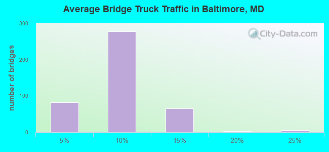
- 904,848Total average daily truck traffic
- National Bridge Inventory (NBI) Registered Bridges for Baltimore
- No street view available for this location
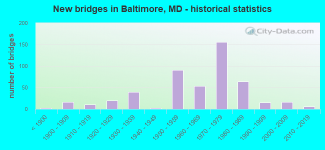
- New bridges - historical statistics
- 2Before 1900
- 161900-1909
- 111910-1919
- 201920-1929
- 391930-1939
- 21940-1949
- 911950-1959
- 541960-1969
- 1561970-1979
- 641980-1989
- 151990-1999
- 162000-2009
- 62010-2019
- 12020-2022
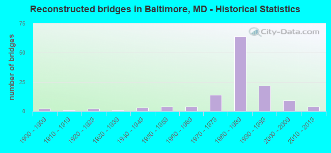
- Reconstructed bridges - Historical Statistics
- 21900-1909
- 11910-1919
- 21920-1929
- 11930-1939
- 31940-1949
- 41950-1959
- 41960-1969
- 141970-1979
- 641980-1989
- 221990-1999
- 92000-2009
- 42010-2019

- Bridge Condition - Deck
- 2.1%Very good
- 48.6%Good
- 34.5%Satisfactory
- 11.1%Fair
- 3.0%Poor
- 0.6%Serious
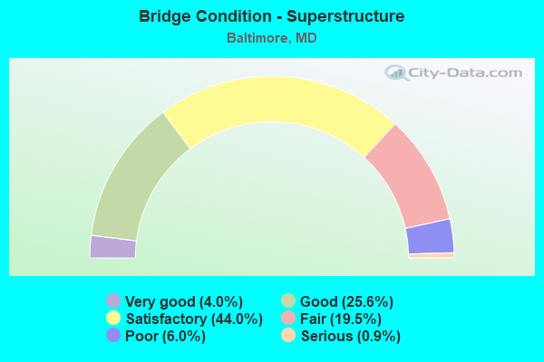
- Bridge Condition - Superstructure
- 4.0%Very good
- 25.6%Good
- 44.0%Satisfactory
- 19.5%Fair
- 6.0%Poor
- 0.9%Serious
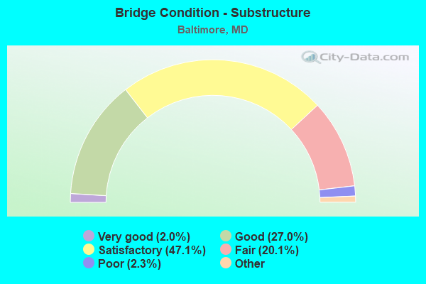
- Bridge Condition - Substructure
- 2.0%Very good
- 27.0%Good
- 47.1%Satisfactory
- 20.1%Fair
- 2.3%Poor
- 1.4%Serious
- 0.9%Critical
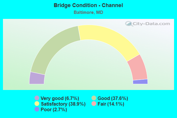
- Bridge Condition - Channel
- 6.7%Very good
- 37.6%Good
- 38.9%Satisfactory
- 14.1%Fair
- 2.7%Poor
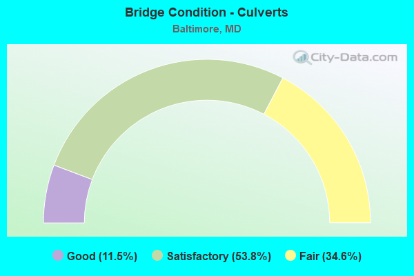
- Bridge Condition - Culverts
- 11.5%Good
- 53.8%Satisfactory
- 34.6%Fair
Find on map >> Show street view
Structure Number: 10000020001402, Location: 3.44 MI W OF CAROLINE CO (Lat: 39.353778, Lng: -76.618283), Route carried "on" structure: State highway 328, Year Built: 1944, Status: Open, Structure Length: 1.95m (6.40ft), Average Daily Traffic: 10,230 (year 2009), Truck Traffic: 8%, Average Future Daily Traffic: 12,706 (year 2026), Design Load: H 20, Features Intersected: BEAVERDAM BRANCH
Minimum Vertical Clearance: 30+ m (98+ ft), Kilometerpoint: 8.769, Lanes on structure: 2, Base Highway Network: Yes, Owner: State Highway Agency, Approaching Roadway Width: 11.6m (38.1ft), Material/Design: Concrete, Design/Construction: Culvert, Length of Maximum Span: 3.0m (9.8ft)
Condition: Channel: Very good, Culverts: Satisfactory, Operating Rating: 89.8 metric tons, Method Used To Determine Operating Rating: Load Factor (LF), Inventory Rating: 70.7 metric tons, Method Used To Determine Inventory Rating: Load Factor (LF), Structural Evaluation: Equal to present minimum criteria, Waterway Adequacy: Equal to present desirable criteria, Approach Roadway Alignment: Equal to present desirable criteria, Designated Inspection Frequency: Every 24 months, Inspection Date: August 2021
Find on map >> Show street view
Structure Number: 200000BC110101, Location: AT CHARLES ST. OVER I-83 (Lat: 39.307531, Lng: -76.616817), Route carried "on" structure: Ramp Interstate 83, Year Built: 2003, Status: Open, Structure Length: 5.61m (18.41ft), Average Daily Traffic: 10,236 (year 2016), Truck Traffic: 5%, Average Future Daily Traffic: 12,123 (year 2033), Design Load: HS 25 or greater, Features Intersected: AMTRAK PROPERTY, Facility Carried by Structure: CHARLES STREET ON-
Minimum Vertical Clearance: 30+ m (98+ ft), Kilometerpoint: 22.220, Lanes on structure: 2, Base Highway Network: Yes, Owner: City or Municipal Highway Agency, Approaching Roadway Width: 17.1m (56.1ft), Skew: 20 degrees, Material/Design: Steel, Design/Construction: Stringer/Multi-beam, Number Of Spans In Main Unit: 2, Length of Maximum Span: 28.3m (92.8ft), Curb-To-Curb Width: 12.8m (42.0ft), Out-to-Out Width: 18.0m (59.1ft)
Condition: Deck: Good, Superstructure: Good, Substructure: Good, Inventory Rating: 62.1 metric tons, Method Used To Determine Inventory Rating: Load Factor (LF), Structural Evaluation: Better than present minimum criteria, Deck Geometry: Superior to present desirable criteria, Approach Roadway Alignment: Equal to present desirable criteria, Length Of Structure Improvement: 5.61m (18.41ft), Designated Inspection Frequency: Every 24 months, Inspection Date: November 2020, Roadway Improvement Cost: $1,000, Total Project Cost: $1,000, Deck Structure Type: Concrete Cast-file-Place
Find on map >> Show street view
Structure Number: 200000BC110301, Location: 0.03 MI W OF NORTH AVE (Lat: 39.311353, Lng: -76.624233), Route carried "on" structure: Interstate 83, Year Built: 1959, Year Reconstructed: 1988, Status: Open, Structure Length: 36.06m (118.31ft), Average Daily Traffic: 127,291 (year 2015), Truck Traffic: 8%, Average Future Daily Traffic: 155,319 (year 2035), Design Load: HS 20, Features Intersected: CSX, MTA, AMTRAK AND NOR
Minimum Vertical Clearance: 30+ m (98+ ft), Kilometerpoint: 22.220, Lanes on structure: 7, Lanes under structure: 4, Base Highway Network: Yes, Owner: City or Municipal Highway Agency, Approaching Roadway Width: 34.7m (113.8ft), Skew: 39 degrees, Material/Design: Steel continuous, Design/Construction: Stringer/Multi-beam, Number Of Spans In Main Unit: 4, Number Of Approach Spans: 11, Length of Maximum Span: 58.2m (190.9ft), Curb-To-Curb Width: 34.7m (113.8ft), Out-to-Out Width: 35.7m (117.1ft)
Condition: Deck: Good, Superstructure: Satisfactory, Substructure: Fair, Operating Rating: 79.8 metric tons, Method Used To Determine Operating Rating: Load Factor (LF), Inventory Rating: 47.6 metric tons, Method Used To Determine Inventory Rating: Load Factor (LF), Structural Evaluation: Somewhat better than minimum adequacy, Deck Geometry: Superior to present desirable criteria, Underclear: High priority of corrective action, Approach Roadway Alignment: Equal to present desirable criteria, Length Of Structure Improvement: 36.06m (118.31ft), Designated Inspection Frequency: Every 24 months, Other Special Inspection Frequency: Every 72 months, Inspection Date: August 2020, Other Special Inspection Date: August 2020, Bridge Improvement Cost: $272,000, Roadway Improvement Cost: $27,000, Total Project Cost: $299,000 ( Estimate for 2016), Deck Structure Type: Concrete Cast-file-Place, Wearing Surface/Protective System: Wearing Surface: Monolithic Concrete, Deck Protection: Epoxy Coated Reinforcing
Find on map >> Show street view
Structure Number: 200000BC110401, Location: ON RAMP TO SB I-83 (Lat: 39.310258, Lng: -76.622503), Route carried "on" structure: Ramp Interstate 83, Year Built: 1959, Year Reconstructed: 1988, Status: Open, Structure Length: 5.46m (17.91ft), Average Daily Traffic: 5,581 (year 2011), Truck Traffic: 8%, Average Future Daily Traffic: 6,610 (year 2028), Design Load: HS 20, Features Intersected: I-83 SB, Facility Carried by Structure: NORTH AVE. ON-RAMP
Minimum Vertical Clearance: 30+ m (98+ ft), Kilometerpoint: 22.220, Lanes on structure: 1, Owner: City or Municipal Highway Agency, Approaching Roadway Width: 6.7m (22.0ft), Material/Design: Steel, Design/Construction: Stringer/Multi-beam, Number Of Spans In Main Unit: 3, Length of Maximum Span: 18.0m (59.1ft), Curb-To-Curb Width: 6.7m (22.0ft), Out-to-Out Width: 7.7m (25.3ft)
Condition: Deck: Good, Superstructure: Satisfactory, Substructure: Fair, Inventory Rating: 68.5 metric tons, Method Used To Determine Inventory Rating: Load Factor (LF), Structural Evaluation: Somewhat better than minimum adequacy, Deck Geometry: Equal to present minimum criteria, Approach Roadway Alignment: Equal to present desirable criteria, Length Of Structure Improvement: 5.46m (17.91ft), Designated Inspection Frequency: Every 24 months, Inspection Date: November 2021, Bridge Improvement Cost: $18,000, Total Project Cost: $18,000, Deck Structure Type: Concrete Cast-file-Place, Wearing Surface/Protective System: Deck Protection: Epoxy Coated Reinforcing
Find on map >> Show street view
Structure Number: 200000BC110501, Location: I-83 OVER RAMP FROM N AVE (Lat: 39.312650, Lng: -76.625497), Route carried "on" structure: Interstate 83, Year Built: 1959, Year Reconstructed: 1988, Status: Open, Structure Length: 2.01m (6.59ft), Average Daily Traffic: 4,726 (year 2016), Truck Traffic: 8%, Average Future Daily Traffic: 5,597 (year 2033), Design Load: HS 20, Features Intersected: ON-RAMP TO NB I-83 FROM
Minimum Vertical Clearance: 30+ m (98+ ft), Kilometerpoint: 22.220, Lanes on structure: 6, Lanes under structure: 2, Base Highway Network: Yes, Owner: City or Municipal Highway Agency, Approaching Roadway Width: 31.1m (102.0ft), Skew: 33 degrees, Material/Design: Steel, Design/Construction: Stringer/Multi-beam, Number Of Spans In Main Unit: 1, Length of Maximum Span: 18.9m (62.0ft), Curb-To-Curb Width: 31.1m (102.0ft), Out-to-Out Width: 32.1m (105.3ft)
Condition: Deck: Satisfactory, Superstructure: Satisfactory, Substructure: Fair, Inventory Rating: 62.6 metric tons, Method Used To Determine Inventory Rating: Load Factor (LF), Structural Evaluation: Somewhat better than minimum adequacy, Deck Geometry: Superior to present desirable criteria, Underclear: High priority of corrective action, Approach Roadway Alignment: Equal to present desirable criteria, Length Of Structure Improvement: 2.01m (6.59ft), Designated Inspection Frequency: Every 24 months, Inspection Date: August 2020, Bridge Improvement Cost: $44,000, Roadway Improvement Cost: $13,000, Total Project Cost: $57,000, Deck Structure Type: Concrete Cast-file-Place, Wearing Surface/Protective System: Deck Protection: Epoxy Coated Reinforcing
Find on map >> Show street view
Structure Number: 200000BC110601, Location: I-170 WB RAMP OVER ACCESS (Lat: 39.294436, Lng: -76.627061), Route carried "on" structure: Ramp Interstate 170, Year Built: 1979, Status: Open, Structure Length: 0.98m (3.22ft), Average Daily Traffic: 23,415 (year 2021), Truck Traffic: 8%, Average Future Daily Traffic: 29,141 (year 2041), Design Load: HS 20, Features Intersected: ACCESS ROAD
Minimum Vertical Clearance: 30+ m (98+ ft), Kilometerpoint: 0.000, Lanes on structure: 2, Owner: City or Municipal Highway Agency, Approaching Roadway Width: 12.2m (40.0ft), Material/Design: Concrete, Design/Construction: Slab, Number Of Spans In Main Unit: 1, Length of Maximum Span: 9.1m (29.9ft), Curb-To-Curb Width: 12.4m (40.7ft), Out-to-Out Width: 13.4m (44.0ft)
Condition: Deck: Satisfactory, Superstructure: Satisfactory, Substructure: Fair, Operating Rating: 32.7 metric tons, Method Used To Determine Operating Rating: Field evaluation and documented engineering judgment, Inventory Rating: 32.7 metric tons, Method Used To Determine Inventory Rating: Field evaluation and documented engineering judgment, Structural Evaluation: Somewhat better than minimum adequacy, Deck Geometry: Superior to present desirable criteria, Approach Roadway Alignment: Equal to present desirable criteria, Designated Inspection Frequency: Every 12 months, Inspection Date: November 2021, Deck Structure Type: Concrete Cast-file-Place, Wearing Surface/Protective System: Wearing Surface: Monolithic Concrete
Find on map >> Show street view
Structure Number: 200000BC1106014, Location: 0.7 MI. N. OF FAYETTE ST. (Lat: 39.294428, Lng: -76.627242), Route carried "on" structure: Ramp Interstate 170, Year Built: 1979, Status: Open, Structure Length: 11.13m (36.52ft), Average Daily Traffic: 19,900 (year 2007), Truck Traffic: 8%, Average Future Daily Traffic: 24,800 (year 2033), Design Load: HS 20, Features Intersected: M.L.K. BLVD
Minimum Vertical Clearance: 30+ m (98+ ft), Kilometerpoint: 2.896, Lanes on structure: 2, Lanes under structure: 7, Owner: City or Municipal Highway Agency, Approaching Roadway Width: 12.2m (40.0ft), Material/Design: Concrete continuous, Design/Construction: Box Beam or Girders - Multiple, Number Of Spans In Main Unit: 4, Length of Maximum Span: 33.5m (109.9ft), Curb-To-Curb Width: 12.5m (41.0ft), Out-to-Out Width: 13.4m (44.0ft)
Condition: Deck: Satisfactory, Superstructure: Satisfactory, Substructure: Satisfactory, Inventory Rating: 60.3 metric tons, Method Used To Determine Inventory Rating: Load Factor (LF), Structural Evaluation: Equal to present minimum criteria, Deck Geometry: Superior to present desirable criteria, Underclear: Somewhat better than minimum adequacy, Approach Roadway Alignment: Equal to present desirable criteria, Length Of Structure Improvement: 11.13m (36.52ft), Designated Inspection Frequency: Every 24 months, Inspection Date: July 2020, Bridge Improvement Cost: $18,000, Roadway Improvement Cost: $8,000, Total Project Cost: $26,000, Deck Structure Type: Concrete Cast-file-Place, Wearing Surface/Protective System: Wearing Surface: Monolithic Concrete
Find on map >> Show street view
Structure Number: 200000BC110701, Location: I-170 EB RAMP OVER ACCESS (Lat: 39.293797, Lng: -76.627144), Route carried "on" structure: Ramp Interstate 170, Year Built: 1979, Status: Open, Structure Length: 0.94m (3.08ft), Average Daily Traffic: 1,292 (year 2021), Truck Traffic: 8%, Average Future Daily Traffic: 1,608 (year 2041), Design Load: HS 20, Features Intersected: ACCESS ROAD
Minimum Vertical Clearance: 30+ m (98+ ft), Kilometerpoint: 0.729, Lanes on structure: 2, Owner: City or Municipal Highway Agency, Approaching Roadway Width: 12.2m (40.0ft), Material/Design: Concrete, Design/Construction: Slab, Number Of Spans In Main Unit: 1, Length of Maximum Span: 9.1m (29.9ft), Curb-To-Curb Width: 12.4m (40.7ft), Out-to-Out Width: 13.4m (44.0ft)
Condition: Deck: Satisfactory, Superstructure: Satisfactory, Substructure: Fair, Operating Rating: 32.7 metric tons, Method Used To Determine Operating Rating: Field evaluation and documented engineering judgment, Inventory Rating: 32.7 metric tons, Method Used To Determine Inventory Rating: Field evaluation and documented engineering judgment, Structural Evaluation: Somewhat better than minimum adequacy, Deck Geometry: Superior to present desirable criteria, Approach Roadway Alignment: Equal to present desirable criteria, Designated Inspection Frequency: Every 12 months, Inspection Date: November 2021, Deck Structure Type: Concrete Cast-file-Place, Wearing Surface/Protective System: Wearing Surface: Monolithic Concrete
Find on map >> Show street view
Structure Number: 200000BC1107013, Location: 0.7 MI. N. OF FAYETTE ST. (Lat: 39.293756, Lng: -76.628497), Route carried "on" structure: Ramp Interstate 170, Year Built: 1979, Status: Open, Structure Length: 11.13m (36.52ft), Average Daily Traffic: 19,900 (year 2007), Truck Traffic: 8%, Average Future Daily Traffic: 24,800 (year 2027), Design Load: HS 20, Features Intersected: M.L.K. BLVD
Minimum Vertical Clearance: 30+ m (98+ ft), Kilometerpoint: 2.896, Lanes on structure: 2, Lanes under structure: 7, Base Highway Network: Yes, Owner: City or Municipal Highway Agency, Approaching Roadway Width: 12.2m (40.0ft), Material/Design: Concrete continuous, Design/Construction: Box Beam or Girders - Multiple, Number Of Spans In Main Unit: 4, Length of Maximum Span: 33.5m (109.9ft), Curb-To-Curb Width: 12.4m (40.7ft), Out-to-Out Width: 13.4m (44.0ft)
Condition: Deck: Satisfactory, Superstructure: Satisfactory, Substructure: Satisfactory, Inventory Rating: 60.3 metric tons, Method Used To Determine Inventory Rating: Load Factor (LF), Structural Evaluation: Equal to present minimum criteria, Deck Geometry: Superior to present desirable criteria, Underclear: Somewhat better than minimum adequacy, Approach Roadway Alignment: Equal to present desirable criteria, Length Of Structure Improvement: 11.13m (36.52ft), Designated Inspection Frequency: Every 24 months, Inspection Date: May 2020, Bridge Improvement Cost: $25,000, Roadway Improvement Cost: $2,000, Total Project Cost: $27,000, Deck Structure Type: Concrete Cast-file-Place, Wearing Surface/Protective System: Wearing Surface: Monolithic Concrete
Find on map >> Show street view
Structure Number: 200000BC1110011, Location: 0.1 MI N OF ORLEANS ST (Lat: 39.295597, Lng: -76.610681), Route carried "on" structure: Interstate 83, Year Built: 1976, Status: Open, Structure Length: 62.27m (204.30ft), Average Daily Traffic: 71,820 (year 2007), Truck Traffic: 8%, Average Future Daily Traffic: 87,620 (year 2027), Design Load: HS 20, Features Intersected: CENTRE STREET
Minimum Vertical Clearance: 30+ m (98+ ft), Kilometerpoint: 6.114, Lanes on structure: 3, Lanes under structure: 7, Base Highway Network: Yes, Owner: City or Municipal Highway Agency, Approaching Roadway Width: 17.4m (57.1ft), Material/Design: Steel continuous, Design/Construction: Stringer/Multi-beam, Number Of Spans In Main Unit: 23, Length of Maximum Span: 32.6m (107.0ft), Curb-To-Curb Width: 15.4m (50.5ft), Out-to-Out Width: 16.5m (54.1ft)
Condition: Deck: Fair, Superstructure: Fair, Substructure: Fair, Operating Rating: 75.3 metric tons, Method Used To Determine Operating Rating: Load Factor (LF), Inventory Rating: 44.9 metric tons, Method Used To Determine Inventory Rating: Load Factor (LF), Structural Evaluation: Somewhat better than minimum adequacy, Deck Geometry: Somewhat better than minimum adequacy, Underclear: Meets minimum limits, Approach Roadway Alignment: Equal to present desirable criteria, Length Of Structure Improvement: 62.27m (204.30ft), Designated Inspection Frequency: Every 24 months, Critical Feature Inspection Frequency: Every 24 months, Inspection Date: March 2020, Critical Feature Inspection Date: March 2020, Bridge Improvement Cost: $127,000, Roadway Improvement Cost: $2,000, Total Project Cost: $129,000, Deck Structure Type: Concrete Cast-file-Place
Find on map >> Show street view
Structure Number: 200000BC1111012, Location: 0.1 MI N OF ORLEANS ST (Lat: 39.295569, Lng: -76.611047), Route carried "on" structure: Interstate 83, Year Built: 1976, Status: Open, Structure Length: 62.42m (204.79ft), Average Daily Traffic: 72,540 (year 2016), Truck Traffic: 8%, Average Future Daily Traffic: 88,500 (year 2036), Design Load: HS 20, Features Intersected: CENTRE STREET & MADISON
Minimum Vertical Clearance: 30+ m (98+ ft), Kilometerpoint: 6.114, Lanes on structure: 3, Lanes under structure: 4, Base Highway Network: Yes, Owner: City or Municipal Highway Agency, Approaching Roadway Width: 17.4m (57.1ft), Material/Design: Steel continuous, Design/Construction: Stringer/Multi-beam, Number Of Spans In Main Unit: 23, Length of Maximum Span: 32.6m (107.0ft), Curb-To-Curb Width: 14.8m (48.6ft), Out-to-Out Width: 16.5m (54.1ft)
Condition: Deck: Fair, Superstructure: Fair, Substructure: Satisfactory, Operating Rating: 88.4 metric tons, Method Used To Determine Operating Rating: Load Factor (LF), Inventory Rating: 53.1 metric tons, Method Used To Determine Inventory Rating: Load Factor (LF), Structural Evaluation: Somewhat better than minimum adequacy, Deck Geometry: Meets minimum limits, Underclear: Better than present minimum criteria, Approach Roadway Alignment: Equal to present desirable criteria, Length Of Structure Improvement: 62.42m (204.79ft), Designated Inspection Frequency: Every 24 months, Critical Feature Inspection Frequency: Every 24 months, Inspection Date: September 2020, Critical Feature Inspection Date: September 2020, Bridge Improvement Cost: $300,000, Roadway Improvement Cost: $10,000, Total Project Cost: $310,000, Deck Structure Type: Concrete Cast-file-Place
Find on map >> Show street view
Structure Number: 200000BC111201, Location: 0.2 MI N OF MADISON ST (Lat: 39.299828, Lng: -76.610981), Route carried "on" structure: Ramp Interstate 83, Year Built: 1976, Status: Open, Structure Length: 15.09m (49.51ft), Average Daily Traffic: 7,575 (year 2007), Truck Traffic: 8%, Average Future Daily Traffic: 9,240 (year 2027), Design Load: HS 20, Features Intersected: PARKING LOTS
Minimum Vertical Clearance: 4.27m (14.01ft), Kilometerpoint: 6.275, Lanes on structure: 1, Owner: City or Municipal Highway Agency, Approaching Roadway Width: 7.3m (24.0ft), Material/Design: Steel continuous, Design/Construction: Stringer/Multi-beam, Number Of Spans In Main Unit: 6, Length of Maximum Span: 30.5m (100.1ft), Curb-To-Curb Width: 6.2m (20.3ft), Out-to-Out Width: 7.6m (24.9ft)
Condition: Deck: Satisfactory, Superstructure: Satisfactory, Substructure: Satisfactory, Operating Rating: 58.5 metric tons, Method Used To Determine Operating Rating: Load Factor (LF), Inventory Rating: 34.9 metric tons, Method Used To Determine Inventory Rating: Load Factor (LF), Structural Evaluation: Equal to present minimum criteria, Deck Geometry: High priority of corrective action, Approach Roadway Alignment: Equal to present minimum criteria, Length Of Structure Improvement: 15.09m (49.51ft), Designated Inspection Frequency: Every 24 months, Critical Feature Inspection Frequency: Every 24 months, Inspection Date: March 2020, Critical Feature Inspection Date: March 2020, Bridge Improvement Cost: $29,000, Roadway Improvement Cost: $10,000, Total Project Cost: $39,000, Deck Structure Type: Concrete Cast-file-Place, Wearing Surface/Protective System: Wearing Surface: Monolithic Concrete
Find on map >> Show street view
Structure Number: 200000BC111301, Location: 0.4 MI N OF MADISON ST (Lat: 39.301014, Lng: -8.067883), Route carried "on" structure: Ramp Interstate 83, Year Built: 1976, Status: Open, Structure Length: 12.98m (42.59ft), Average Daily Traffic: 7,014 (year 2020), Truck Traffic: 8%, Average Future Daily Traffic: 8,279 (year 2040), Design Load: HS 20, Features Intersected: GUILFORD AVE
Minimum Vertical Clearance: 30+ m (98+ ft), Kilometerpoint: 6.597, Lanes on structure: 1, Lanes under structure: 3, Owner: City or Municipal Highway Agency, Approaching Roadway Width: 6.7m (22.0ft), Material/Design: Steel continuous, Design/Construction: Stringer/Multi-beam, Number Of Spans In Main Unit: 4, Length of Maximum Span: 42.7m (140.1ft), Curb-To-Curb Width: 6.7m (22.0ft), Out-to-Out Width: 7.8m (25.6ft)
Condition: Deck: Good, Superstructure: Good, Substructure: Satisfactory, Operating Rating: 68.5 metric tons, Method Used To Determine Operating Rating: Load Factor (LF), Inventory Rating: 40.8 metric tons, Method Used To Determine Inventory Rating: Load Factor (LF), Structural Evaluation: Equal to present minimum criteria, Deck Geometry: Equal to present minimum criteria, Underclear: High priority of corrective action, Approach Roadway Alignment: Equal to present minimum criteria, Length Of Structure Improvement: 13.05m (42.81ft), Designated Inspection Frequency: Every 24 months, Critical Feature Inspection Frequency: Every 24 months, Inspection Date: December 2020, Critical Feature Inspection Date: December 2020, Bridge Improvement Cost: $46,000, Roadway Improvement Cost: $3,000, Total Project Cost: $49,000 ( Estimate for 2016), Deck Structure Type: Concrete Cast-file-Place, Wearing Surface/Protective System: Wearing Surface: Monolithic Concrete, Deck Protection: Epoxy Coated Reinforcing
Find on map >> Show street view
Structure Number: 200000BC111401, Location: 0.3 MI. E OF CALVERT ST (Lat: 39.301078, Lng: -76.611003), Route carried "on" structure: Ramp Interstate 83, Year Built: 1976, Status: Open, Structure Length: 22.26m (73.03ft), Average Daily Traffic: 6,081 (year 2016), Truck Traffic: 8%, Average Future Daily Traffic: 7,415 (year 2036), Design Load: HS 20, Features Intersected: RAMP B
Minimum Vertical Clearance: 30+ m (98+ ft), Kilometerpoint: 6.436, Lanes on structure: 1, Lanes under structure: 3, Owner: City or Municipal Highway Agency, Approaching Roadway Width: 6.1m (20.0ft), Material/Design: Steel continuous, Design/Construction: Stringer/Multi-beam, Number Of Spans In Main Unit: 9, Length of Maximum Span: 31.7m (104.0ft), Curb-To-Curb Width: 6.2m (20.3ft), Out-to-Out Width: 7.3m (24.0ft)
Condition: Deck: Satisfactory, Superstructure: Fair, Substructure: Satisfactory, Operating Rating: 71.2 metric tons, Method Used To Determine Operating Rating: Load Factor (LF), Inventory Rating: 42.6 metric tons, Method Used To Determine Inventory Rating: Load Factor (LF), Structural Evaluation: Somewhat better than minimum adequacy, Deck Geometry: Somewhat better than minimum adequacy, Underclear: Meets minimum limits, Approach Roadway Alignment: Equal to present desirable criteria, Length Of Structure Improvement: 22.34m (73.29ft), Designated Inspection Frequency: Every 24 months, Critical Feature Inspection Frequency: Every 24 months, Inspection Date: March 2020, Critical Feature Inspection Date: March 2020, Bridge Improvement Cost: $26,000, Total Project Cost: $26,000, Deck Structure Type: Concrete Cast-file-Place, Wearing Surface/Protective System: Deck Protection: Epoxy Coated Reinforcing
Find on map >> Show street view
Structure Number: 200000BC111501, Location: SB JFX OFF-RAMP OV CENTRE (Lat: 39.296667, Lng: -76.611139), Route carried "on" structure: Ramp Interstate 83, Year Built: 1976, Status: Open, Structure Length: 9.42m (30.91ft), Average Daily Traffic: 3,699 (year 2016), Truck Traffic: 8%, Average Future Daily Traffic: 4,380 (year 2033), Design Load: H 20, Features Intersected: CENTRE STREET
Minimum Vertical Clearance: 30+ m (98+ ft), Kilometerpoint: 160.884, Lanes on structure: 1, Lanes under structure: 3, Owner: City or Municipal Highway Agency, Approaching Roadway Width: 6.1m (20.0ft), Material/Design: Steel continuous, Design/Construction: Stringer/Multi-beam, Number Of Spans In Main Unit: 3, Length of Maximum Span: 31.4m (103.0ft), Curb-To-Curb Width: 6.2m (20.3ft), Out-to-Out Width: 7.3m (24.0ft)
Condition: Deck: Satisfactory, Superstructure: Good, Substructure: Satisfactory, Inventory Rating: 54.4 metric tons, Method Used To Determine Inventory Rating: Load Factor (LF), Structural Evaluation: Equal to present minimum criteria, Deck Geometry: Somewhat better than minimum adequacy, Underclear: Superior to present desirable criteria, Approach Roadway Alignment: Equal to present desirable criteria, Length Of Structure Improvement: 9.42m (30.91ft), Designated Inspection Frequency: Every 24 months, Critical Feature Inspection Frequency: Every 24 months, Inspection Date: March 2020, Critical Feature Inspection Date: March 2020, Bridge Improvement Cost: $49,000, Roadway Improvement Cost: $6,000, Total Project Cost: $55,000, Deck Structure Type: Concrete Cast-file-Place, Wearing Surface/Protective System: Wearing Surface: Integral Concrete
Find on map >> Show street view
Structure Number: 200000BC1116011, Location: 0.2 MI S OF ORLEANS ST (Lat: 39.294722, Lng: -76.610719), Route carried "on" structure: Interstate 83, Year Built: 1975, Status: Open, Structure Length: 41.18m (135.10ft), Average Daily Traffic: 79,335 (year 2016), Truck Traffic: 8%, Average Future Daily Traffic: 96,791 (year 2036), Design Load: HS 20, Features Intersected: GAY STREET
Minimum Vertical Clearance: 30+ m (98+ ft), Kilometerpoint: 5.632, Lanes on structure: 3, Lanes under structure: 4, Owner: City or Municipal Highway Agency, Approaching Roadway Width: 15.2m (49.9ft), Skew: 9 degrees, Material/Design: Steel continuous, Design/Construction: Stringer/Multi-beam, Number Of Spans In Main Unit: 15, Length of Maximum Span: 31.4m (103.0ft), Curb-To-Curb Width: 15.4m (50.5ft), Out-to-Out Width: 16.5m (54.1ft)
Condition: Deck: Satisfactory, Superstructure: Satisfactory, Substructure: Satisfactory, Operating Rating: 49.0 metric tons, Method Used To Determine Operating Rating: Load Factor (LF), Inventory Rating: 29.0 metric tons, Method Used To Determine Inventory Rating: Load Factor (LF), Structural Evaluation: Equal to present minimum criteria, Deck Geometry: High priority of corrective action, Underclear: Meets minimum limits, Approach Roadway Alignment: Equal to present desirable criteria, Length Of Structure Improvement: 41.18m (135.10ft), Designated Inspection Frequency: Every 24 months, Critical Feature Inspection Frequency: Every 24 months, Inspection Date: March 2020, Critical Feature Inspection Date: March 2020, Bridge Improvement Cost: $73,000, Roadway Improvement Cost: $19,000, Total Project Cost: $92,000 ( Estimate for 2016), Deck Structure Type: Concrete Cast-file-Place
Find on map >> Show street view
Structure Number: 200000BC1117012, Location: 0.2 MI S OF ORLEANS ST (Lat: 39.295547, Lng: -76.611233), Route carried "on" structure: Interstate 83, Year Built: 1975, Status: Open, Structure Length: 44.33m (145.44ft), Average Daily Traffic: 80,130 (year 2017), Truck Traffic: 8%, Average Future Daily Traffic: 94,900 (year 2034), Design Load: HS 20, Features Intersected: GAY STREET
Minimum Vertical Clearance: 5.18m (16.99ft), Kilometerpoint: 5.632, Lanes on structure: 3, Lanes under structure: 4, Owner: City or Municipal Highway Agency, Approaching Roadway Width: 23.5m (77.1ft), Material/Design: Steel continuous, Design/Construction: Stringer/Multi-beam, Number Of Spans In Main Unit: 15, Length of Maximum Span: 31.4m (103.0ft), Curb-To-Curb Width: 15.4m (50.5ft), Out-to-Out Width: 16.5m (54.1ft)
Condition: Deck: Satisfactory, Superstructure: Satisfactory, Substructure: Satisfactory, Operating Rating: 43.1 metric tons, Method Used To Determine Operating Rating: Load Factor (LF), Inventory Rating: 25.4 metric tons, Method Used To Determine Inventory Rating: Load Factor (LF), Structural Evaluation: Equal to present minimum criteria, Deck Geometry: Somewhat better than minimum adequacy, Underclear: Meets minimum limits, Approach Roadway Alignment: Equal to present desirable criteria, Length Of Structure Improvement: 41.12m (134.91ft), Designated Inspection Frequency: Every 24 months, Critical Feature Inspection Frequency: Every 24 months, Inspection Date: June 2020, Critical Feature Inspection Date: June 2020, Bridge Improvement Cost: $106,000, Roadway Improvement Cost: $4,000, Total Project Cost: $110,000, Deck Structure Type: Concrete Cast-file-Place
Find on map >> Show street view
Structure Number: 200000BC111801, Location: I-83 OVER HILLEN STREET (Lat: 39.493869, Lng: -77.017167), Route carried "on" structure: Ramp Interstate 83, Year Built: 1975, Status: Open, Structure Length: 6.46m (21.19ft), Average Daily Traffic: 71,820 (year 2007), Truck Traffic: 8%, Average Future Daily Traffic: 87,620 (year 2027), Design Load: HS 20, Features Intersected: HILLEN STREET
Minimum Vertical Clearance: 30+ m (98+ ft), Kilometerpoint: 5.792, Lanes on structure: 1, Lanes under structure: 3, Owner: City or Municipal Highway Agency, Approaching Roadway Width: 5.5m (18.0ft), Material/Design: Steel continuous, Design/Construction: Stringer/Multi-beam, Number Of Spans In Main Unit: 3, Length of Maximum Span: 24.1m (79.1ft), Curb-To-Curb Width: 5.7m (18.7ft), Out-to-Out Width: 6.9m (22.6ft)
Condition: Deck: Satisfactory, Superstructure: Satisfactory, Substructure: Fair, Operating Rating: 69.8 metric tons, Method Used To Determine Operating Rating: Load Factor (LF), Inventory Rating: 41.7 metric tons, Method Used To Determine Inventory Rating: Load Factor (LF), Structural Evaluation: Somewhat better than minimum adequacy, Deck Geometry: Meets minimum limits, Underclear: Meets minimum limits, Approach Roadway Alignment: Equal to present desirable criteria, Length Of Structure Improvement: 6.46m (21.19ft), Designated Inspection Frequency: Every 24 months, Critical Feature Inspection Frequency: Every 24 months, Inspection Date: June 2020, Critical Feature Inspection Date: June 2020, Bridge Improvement Cost: $8,000, Roadway Improvement Cost: $9,000, Total Project Cost: $17,000, Deck Structure Type: Concrete Cast-file-Place
Find on map >> Show street view
Structure Number: 200000BC120101, Location: 0.5 MI S OF NORTH AVE (Lat: 39.302194, Lng: -76.647611), Route carried "on" structure: US 1, Year Built: 1900, Year Reconstructed: 1986, Status: Open, Structure Length: 5.97m (19.59ft), Average Daily Traffic: 9,900 (year 2007), Truck Traffic: 10%, Average Future Daily Traffic: 12,300 (year 2027), Design Load: HS 20, Features Intersected: AMTRAK
Minimum Vertical Clearance: 30+ m (98+ ft), Kilometerpoint: 0.032, Lanes on structure: 2, Owner: City or Municipal Highway Agency, Approaching Roadway Width: 13.4m (44.0ft), Material/Design: Steel, Design/Construction: Stringer/Multi-beam, Number Of Spans In Main Unit: 3, Length of Maximum Span: 24.1m (79.1ft), Curb or Sidewalk Widths: Left: 2.7m (8.9ft), Right: 2.7m (8.9ft), Curb-To-Curb Width: 13.4m (44.0ft), Out-to-Out Width: 19.5m (64.0ft)
Condition: Deck: Good, Superstructure: Satisfactory, Substructure: Satisfactory, Operating Rating: 32.7 metric tons, Method Used To Determine Operating Rating: Field evaluation and documented engineering judgment, Inventory Rating: 32.7 metric tons, Method Used To Determine Inventory Rating: Field evaluation and documented engineering judgment, Structural Evaluation: Equal to present minimum criteria, Deck Geometry: Superior to present desirable criteria, Underclear: High priority of corrective action, Approach Roadway Alignment: Equal to present desirable criteria, Length Of Structure Improvement: 5.97m (19.59ft), Designated Inspection Frequency: Every 24 months, Inspection Date: May 2020, Bridge Improvement Cost: $8,000, Roadway Improvement Cost: $3,000, Total Project Cost: $11,000, Deck Structure Type: Concrete Cast-file-Place, Wearing Surface/Protective System: Wearing Surface: Monolithic Concrete
Find on map >> Show street view
Structure Number: 200000BC120201, Location: 0.2 MI W OF IS 83 (Lat: 39.294417, Lng: -76.613786), Route carried "on" structure: US 40, Year Built: 1936, Year Reconstructed: 1983, Status: Open, Structure Length: 52.67m (172.80ft), Average Daily Traffic: 11,380 (year 2021), Truck Traffic: 8%, Average Future Daily Traffic: 13,886 (year 2041), Design Load: H 20, Features Intersected: I-83 AND CITY STREETS
Minimum Vertical Clearance: 30+ m (98+ ft), Kilometerpoint: 0.032, Lanes on structure: 6, Lanes under structure: 11, Base Highway Network: Yes, Owner: City or Municipal Highway Agency, Approaching Roadway Width: 16.5m (54.1ft), Skew: 4 degrees, Material/Design: Steel, Design/Construction: Girder and Floorbeam System, Number Of Spans In Main Unit: 15, Number Of Approach Spans: 3, Length of Maximum Span: 33.5m (109.9ft), Curb or Sidewalk Widths: Left: 0.6m (2.0ft), Right: 1.5m (4.9ft), Curb-To-Curb Width: 18.3m (60.0ft), Out-to-Out Width: 20.8m (68.2ft)
Condition: Deck: Satisfactory, Superstructure: Fair, Substructure: Fair, Operating Rating: 50.8 metric tons, Method Used To Determine Operating Rating: Load Factor (LF), Inventory Rating: 30.4 metric tons, Method Used To Determine Inventory Rating: Load Factor (LF), Structural Evaluation: Somewhat better than minimum adequacy, Deck Geometry: High priority of replacement, Underclear: High priority of corrective action, Approach Roadway Alignment: Equal to present minimum criteria, Length Of Structure Improvement: 47.49m (155.81ft), Designated Inspection Frequency: Every 12 months, Critical Feature Inspection Frequency: Every 12 months, Other Special Inspection Frequency: Every 12 months, Inspection Date: November 2021, Critical Feature Inspection Date: November 2021, Other Special Inspection Date: November 2021, Bridge Improvement Cost: $972,000, Roadway Improvement Cost: $25,000, Total Project Cost: $997,000, Deck Structure Type: Concrete Cast-file-Place
Find on map >> Show street view
Structure Number: 200000BC120301, Location: 0.2 MI N MD STATE PEN (Lat: 39.303622, Lng: -76.611433), Route carried "on" structure: City street 4020, Year Built: 1930, Year Reconstructed: 1993, Status: Open, Structure Length: 6.34m (20.80ft), Average Daily Traffic: 18,180 (year 2007), Truck Traffic: 5%, Average Future Daily Traffic: 22,180 (year 2027), Design Load: HS 20, Features Intersected: I-83, ABANDONED RR, Facility Carried by Structure: BIDDLE STREET
Minimum Vertical Clearance: 30+ m (98+ ft), Kilometerpoint: 3.025, Lanes on structure: 3, Lanes under structure: 6, Owner: City or Municipal Highway Agency, Approaching Roadway Width: 12.2m (40.0ft), Material/Design: Steel, Design/Construction: Stringer/Multi-beam, Number Of Spans In Main Unit: 1, Number Of Approach Spans: 2, Length of Maximum Span: 31.4m (103.0ft), Curb or Sidewalk Widths: Left: 3.7m (12.1ft), Right: 3.7m (12.1ft), Curb-To-Curb Width: 12.2m (40.0ft), Out-to-Out Width: 20.4m (66.9ft)
Condition: Deck: Good, Superstructure: Good, Substructure: Satisfactory, Inventory Rating: 57.1 metric tons, Method Used To Determine Inventory Rating: Load Factor (LF), Structural Evaluation: Equal to present minimum criteria, Deck Geometry: Meets minimum limits, Underclear: High priority of corrective action, Approach Roadway Alignment: Equal to present desirable criteria, Length Of Structure Improvement: 6.34m (20.80ft), Designated Inspection Frequency: Every 24 months, Inspection Date: November 2020, Bridge Improvement Cost: $11,000, Roadway Improvement Cost: $1,000, Total Project Cost: $12,000, Deck Structure Type: Concrete Cast-file-Place, Wearing Surface/Protective System: Deck Protection: Epoxy Coated Reinforcing
Find on map >> Show street view
Structure Number: 200000BC120401, Location: 0.3 MI N MD STATE PEN (Lat: 39.304694, Lng: -76.611333), Route carried "on" structure: City street 955, Year Built: 1959, Year Reconstructed: 1993, Status: Open, Structure Length: 4.42m (14.50ft), Average Daily Traffic: 18,200 (year 2007), Truck Traffic: 5%, Average Future Daily Traffic: 22,700 (year 2027), Design Load: HS 20, Features Intersected: I-83 AND ABANDONED RAILR, Facility Carried by Structure: PRESTON STREET
Minimum Vertical Clearance: 30+ m (98+ ft), Kilometerpoint: 3.315, Lanes on structure: 4, Lanes under structure: 6, Owner: City or Municipal Highway Agency, Approaching Roadway Width: 12.2m (40.0ft), Skew: 1 degrees, Material/Design: Steel, Design/Construction: Stringer/Multi-beam, Number Of Spans In Main Unit: 2, Length of Maximum Span: 30.8m (101.0ft), Curb or Sidewalk Widths: Left: 3.7m (12.1ft), Right: 3.7m (12.1ft), Curb-To-Curb Width: 12.2m (40.0ft), Out-to-Out Width: 20.1m (65.9ft)
Condition: Deck: Good, Superstructure: Good, Substructure: Satisfactory, Operating Rating: 88.0 metric tons, Method Used To Determine Operating Rating: Load Factor (LF), Inventory Rating: 52.6 metric tons, Method Used To Determine Inventory Rating: Load Factor (LF), Structural Evaluation: Equal to present minimum criteria, Deck Geometry: High priority of replacement, Underclear: High priority of corrective action, Approach Roadway Alignment: Equal to present desirable criteria, Length Of Structure Improvement: 4.42m (14.50ft), Designated Inspection Frequency: Every 24 months, Inspection Date: November 2020, Bridge Improvement Cost: $10,000, Roadway Improvement Cost: $2,000, Total Project Cost: $12,000, Deck Structure Type: Concrete Cast-file-Place, Wearing Surface/Protective System: Wearing Surface: Monolithic Concrete, Deck Protection: Epoxy Coated Reinforcing
Find on map >> Show street view
Structure Number: 200000BC120501, Location: 0.2 MI S OF NORTH AVE (Lat: 39.522261, Lng: -77.030181), Route carried "on" structure: City street 1510, Year Built: 1960, Year Reconstructed: 1996, Status: Open, Structure Length: 21.64m (71.00ft), Average Daily Traffic: 24,200 (year 2007), Truck Traffic: 5%, Average Future Daily Traffic: 29,040 (year 2027), Design Load: HS 20, Features Intersected: I-83 AND AMTRAK, Facility Carried by Structure: ST. PAUL STREET
Minimum Vertical Clearance: 30+ m (98+ ft), Kilometerpoint: 3.315, Lanes on structure: 4, Lanes under structure: 6, Owner: City or Municipal Highway Agency, Approaching Roadway Width: 15.2m (49.9ft), Skew: 1 degrees, Material/Design: Steel continuous, Design/Construction: Stringer/Multi-beam, Number Of Spans In Main Unit: 6, Length of Maximum Span: 43.6m (143.0ft), Curb or Sidewalk Widths: Left: 2.2m (7.2ft), Right: 2.2m (7.2ft), Curb-To-Curb Width: 15.1m (49.5ft), Out-to-Out Width: 20.1m (65.9ft)
Condition: Deck: Good, Superstructure: Good, Substructure: Satisfactory, Operating Rating: 69.8 metric tons, Method Used To Determine Operating Rating: Load Factor (LF), Inventory Rating: 41.7 metric tons, Method Used To Determine Inventory Rating: Load Factor (LF), Structural Evaluation: Equal to present minimum criteria, Deck Geometry: High priority of corrective action, Underclear: High priority of corrective action, Approach Roadway Alignment: Equal to present desirable criteria, Length Of Structure Improvement: 21.64m (71.00ft), Designated Inspection Frequency: Every 24 months, Inspection Date: November 2020, Bridge Improvement Cost: $2,000, Roadway Improvement Cost: $2,000, Total Project Cost: $4,000, Deck Structure Type: Concrete Cast-file-Place, Wearing Surface/Protective System: Wearing Surface: Monolithic Concrete
Find on map >> Show street view
Structure Number: 200000BC120601, Location: 0.3 MI S OF NORTH AVE (Lat: 39.306528, Lng: -76.616131), Route carried "on" structure: City street 1125, Year Built: 2003, Status: Open, Structure Length: 13.08m (42.91ft), Average Daily Traffic: 20,975 (year 2018), Truck Traffic: 5%, Average Future Daily Traffic: 25,660 (year 2038), Design Load: HS 25 or greater, Features Intersected: I-83, Facility Carried by Structure: CHARLES STREET
Minimum Vertical Clearance: 30+ m (98+ ft), Kilometerpoint: 3.315, Lanes on structure: 5, Lanes under structure: 6, Owner: City or Municipal Highway Agency, Approaching Roadway Width: 13.4m (44.0ft), Skew: 4 degrees, Material/Design: Steel continuous, Design/Construction: Stringer/Multi-beam, Number Of Spans In Main Unit: 5, Length of Maximum Span: 31.7m (104.0ft), Curb or Sidewalk Widths: Left: 3.0m (9.8ft), Right: 3.0m (9.8ft), Curb-To-Curb Width: 13.4m (44.0ft), Out-to-Out Width: 20.1m (65.9ft)
Condition: Deck: Good, Superstructure: Good, Substructure: Good, Inventory Rating: 74.8 metric tons, Method Used To Determine Inventory Rating: Load Factor (LF), Structural Evaluation: Better than present minimum criteria, Deck Geometry: High priority of replacement, Underclear: High priority of corrective action, Approach Roadway Alignment: Equal to present desirable criteria, Length Of Structure Improvement: 13.08m (42.91ft), Designated Inspection Frequency: Every 24 months, Inspection Date: November 2020, Bridge Improvement Cost: $22,000, Roadway Improvement Cost: $6,000, Total Project Cost: $28,000, Deck Structure Type: Concrete Cast-file-Place, Wearing Surface/Protective System: Wearing Surface: Integral Concrete, Deck Protection: Epoxy Coated Reinforcing
Find on map >> Show street view
Structure Number: 200000BC120702, Location: 0.1 MI N OF PRATT ST (Lat: 39.288083, Lng: -76.605086), Route carried "on" structure: City street 150, Year Built: 1974, Status: Open, Structure Length: 2.80m (9.19ft), Average Daily Traffic: 33,775 (year 2016), Truck Traffic: 5%, Average Future Daily Traffic: 50,188 (year 2036), Design Load: HS 20, Features Intersected: JONES FALLS STREAM, Facility Carried by Structure: LOMBARD STREET
Minimum Vertical Clearance: 30+ m (98+ ft), Kilometerpoint: 1.818, Lanes on structure: 5, Owner: City or Municipal Highway Agency, Approaching Roadway Width: 17.1m (56.1ft), Material/Design: Concrete, Design/Construction: Culvert, Length of Maximum Span: 9.1m (29.9ft), Curb or Sidewalk Widths: Left: 2.2m (7.2ft), Right: 2.2m (7.2ft), Curb-To-Curb Width: 17.1m (56.1ft), Out-to-Out Width: 29.8m (97.8ft)
Condition: Channel: Good, Culverts: Satisfactory, Operating Rating: 32.7 metric tons, Method Used To Determine Operating Rating: Field evaluation and documented engineering judgment, Inventory Rating: 32.7 metric tons, Method Used To Determine Inventory Rating: Field evaluation and documented engineering judgment, Structural Evaluation: Equal to present minimum criteria, Deck Geometry: High priority of replacement, Waterway Adequacy: Better than present minimum criteria, Approach Roadway Alignment: Equal to present desirable criteria, Length Of Structure Improvement: 2.59m (8.50ft), Designated Inspection Frequency: Every 12 months, Underwater Inspection Frequency: Every 60 months, Inspection Date: December 2021, Underwater Inspection Date: December 2017, Bridge Improvement Cost: $10,000, Roadway Improvement Cost: $4,000, Total Project Cost: $14,000, Deck Structure Type: Concrete Cast-file-Place
Find on map >> Show street view
Structure Number: 200000BC120801, Location: NORTH AVE OVER CSX (Lat: 39.310822, Lng: -76.622211), Route carried "on" structure: US 1, Year Built: 1895, Year Reconstructed: 1978, Status: Open, Structure Length: 27.07m (88.81ft), Average Daily Traffic: 20,361 (year 2020), Truck Traffic: 15%, Average Future Daily Traffic: 30,256 (year 2040), Design Load: H 20, Features Intersected: JONES FALLS, FALLS RD,RR, Facility Carried by Structure: NORTH AVENUE
Minimum Vertical Clearance: 30+ m (98+ ft), Kilometerpoint: 1.818, Lanes on structure: 6, Lanes under structure: 2, Owner: City or Municipal Highway Agency, Approaching Roadway Width: 22.6m (74.1ft), Skew: 29 degrees, Material/Design: Masonry, Design/Construction: Arch - Deck, Number Of Spans In Main Unit: 7, Length of Maximum Span: 39.6m (129.9ft), Curb or Sidewalk Widths: Left: 4.1m (13.5ft), Right: 1.8m (5.9ft), Curb-To-Curb Width: 22.6m (74.1ft), Out-to-Out Width: 31.5m (103.3ft)
Condition: Superstructure: Fair, Substructure: Fair, Channel: Fair, Operating Rating: 32.7 metric tons, Method Used To Determine Operating Rating: Field evaluation and documented engineering judgment, Inventory Rating: 32.7 metric tons, Method Used To Determine Inventory Rating: Field evaluation and documented engineering judgment, Structural Evaluation: Somewhat better than minimum adequacy, Deck Geometry: Meets minimum limits, Underclear: High priority of corrective action, Waterway Adequacy: Equal to present desirable criteria, Approach Roadway Alignment: Equal to present minimum criteria, Length Of Structure Improvement: 27.07m (88.81ft), Designated Inspection Frequency: Every 24 months, Inspection Date: August 2020, Bridge Improvement Cost: $184,000, Roadway Improvement Cost: $9,000, Total Project Cost: $192,000, Wearing Surface/Protective System: Wearing Surface: Bituminous
Find on map >> Show street view
Structure Number: 200000BC120901, Location: 0.3 MI E GAY ST (Lat: 39.286722, Lng: -76.604944), Route carried "on" structure: State highway 144, Year Built: 1988, Status: Open, Structure Length: 3.29m (10.79ft), Average Daily Traffic: 37,956 (year 2016), Truck Traffic: 5%, Average Future Daily Traffic: 44,951 (year 2036), Design Load: HS 20, Features Intersected: JONES FALLS, Facility Carried by Structure: PRATT STREET
Minimum Vertical Clearance: 30+ m (98+ ft), Kilometerpoint: 1.496, Lanes on structure: 6, Owner: City or Municipal Highway Agency, Approaching Roadway Width: 20.1m (65.9ft), Skew: 1 degrees, Material/Design: Steel, Design/Construction: Stringer/Multi-beam, Number Of Spans In Main Unit: 1, Length of Maximum Span: 31.1m (102.0ft), Curb or Sidewalk Widths: Left: 6.1m (20.0ft), Right: 6.1m (20.0ft), Curb-To-Curb Width: 20.1m (65.9ft), Out-to-Out Width: 32.9m (107.9ft)
Condition: Deck: Good, Superstructure: Satisfactory, Substructure: Good, Channel: Good, Operating Rating: 79.4 metric tons, Method Used To Determine Operating Rating: Load Factor (LF), Inventory Rating: 47.6 metric tons, Method Used To Determine Inventory Rating: Load Factor (LF), Structural Evaluation: Equal to present minimum criteria, Deck Geometry: High priority of replacement, Waterway Adequacy: Equal to present desirable criteria, Approach Roadway Alignment: Better than present minimum criteria, Length Of Structure Improvement: 3.29m (10.79ft), Designated Inspection Frequency: Every 24 months, Underwater Inspection Frequency: Every 60 months, Inspection Date: August 2020, Underwater Inspection Date: November 2017, Bridge Improvement Cost: $66,000, Roadway Improvement Cost: $2,000, Total Project Cost: $68,000, Deck Structure Type: Concrete Cast-file-Place, Wearing Surface/Protective System: Deck Protection: Epoxy Coated Reinforcing
Find on map >> Show street view
Structure Number: 200000BC121001, Location: 0.2 MI N OF MT ROYAL AVE (Lat: 39.307750, Lng: -76.616222), Route carried "on" structure: City street 1125, Year Built: 2003, Status: Open, Structure Length: 7.19m (23.59ft), Average Daily Traffic: 18,800 (year 2014), Truck Traffic: 5%, Average Future Daily Traffic: 23,000 (year 2036), Design Load: HS 25 or greater, Features Intersected: AMTRAK, Facility Carried by Structure: CHARLES STREET
Minimum Vertical Clearance: 30+ m (98+ ft), Kilometerpoint: 2.446, Lanes on structure: 4, Owner: City or Municipal Highway Agency, Approaching Roadway Width: 13.4m (44.0ft), Skew: 3 degrees, Material/Design: Steel continuous, Design/Construction: Stringer/Multi-beam, Number Of Spans In Main Unit: 4, Length of Maximum Span: 20.4m (66.9ft), Curb or Sidewalk Widths: Left: 3.0m (9.8ft), Right: 3.0m (9.8ft), Curb-To-Curb Width: 13.4m (44.0ft), Out-to-Out Width: 20.1m (65.9ft)
Condition: Deck: Very good, Superstructure: Very good, Substructure: Very good, Inventory Rating: 56.2 metric tons, Method Used To Determine Inventory Rating: Load Factor (LF), Structural Evaluation: Equal to present desirable criteria, Deck Geometry: High priority of replacement, Underclear: High priority of corrective action, Approach Roadway Alignment: Equal to present desirable criteria, Length Of Structure Improvement: 7.19m (23.59ft), Designated Inspection Frequency: Every 24 months, Inspection Date: November 2020, Roadway Improvement Cost: $1,000, Total Project Cost: $1,000, Deck Structure Type: Concrete Cast-file-Place, Wearing Surface/Protective System: Wearing Surface: Integral Concrete, Deck Protection: Epoxy Coated Reinforcing
Find on map >> Show street view
Structure Number: 200000BC121101, Location: 0.1 MI S OF FRANKLIN ST (Lat: 39.293125, Lng: -76.645269), Route carried "on" structure: US 1, Year Built: 1975, Status: Open, Structure Length: 6.64m (21.78ft), Average Daily Traffic: 5,600 (year 2007), Truck Traffic: 8%, Average Future Daily Traffic: 6,720 (year 2036), Design Load: HS 20, Features Intersected: I-170, Facility Carried by Structure: FULTON AVENUE
Minimum Vertical Clearance: 30+ m (98+ ft), Kilometerpoint: 2.446, Lanes on structure: 5, Lanes under structure: 6, Owner: City or Municipal Highway Agency, Approaching Roadway Width: 19.5m (64.0ft), Material/Design: Concrete continuous, Design/Construction: Box Beam or Girders - Single/Spread, Number Of Spans In Main Unit: 3, Length of Maximum Span: 23.5m (77.1ft), Curb or Sidewalk Widths: Left: 3.7m (12.1ft), Right: 3.7m (12.1ft), Curb-To-Curb Width: 19.5m (64.0ft), Out-to-Out Width: 27.4m (89.9ft)
Condition: Deck: Satisfactory, Superstructure: Fair, Substructure: Fair, Operating Rating: 78.5 metric tons, Method Used To Determine Operating Rating: Load Factor (LF), Inventory Rating: 46.7 metric tons, Method Used To Determine Inventory Rating: Load Factor (LF), Structural Evaluation: Somewhat better than minimum adequacy, Deck Geometry: Meets minimum limits, Underclear: Meets minimum limits, Approach Roadway Alignment: Equal to present desirable criteria, Length Of Structure Improvement: 6.77m (22.21ft), Designated Inspection Frequency: Every 24 months, Inspection Date: June 2020, Bridge Improvement Cost: $367,000, Roadway Improvement Cost: $67,000, Total Project Cost: $434,000 ( Estimate for 2016), Deck Structure Type: Concrete Cast-file-Place, Wearing Surface/Protective System: Wearing Surface: Bituminous
Find on map >> Show street view
Structure Number: 200000BC121301, Location: 0.1 MI W OF PACA ST (Lat: 39.293603, Lng: -76.624853), Route carried "on" structure: City street 6168, Year Built: 1975, Status: Open, Structure Length: 1.95m (6.40ft), Average Daily Traffic: 22,594 (year 2007), Truck Traffic: 5%, Average Future Daily Traffic: 27,836 (year 2037), Design Load: HS 20, Features Intersected: PEARL STREET, Facility Carried by Structure: MULBERRY STREET
Minimum Vertical Clearance: 30+ m (98+ ft), Kilometerpoint: 3.685, Lanes on structure: 4, Lanes under structure: 2, Owner: City or Municipal Highway Agency, Approaching Roadway Width: 13.4m (44.0ft), Material/Design: Concrete, Design/Construction: Box Beam or Girders - Single/Spread, Number Of Spans In Main Unit: 1, Length of Maximum Span: 18.6m (61.0ft), Curb or Sidewalk Widths: Left: 0.0m, Right: 3.0m (9.8ft), Curb-To-Curb Width: 13.4m (44.0ft), Out-to-Out Width: 17.3m (56.8ft)
Condition: Deck: Good, Superstructure: Satisfactory, Substructure: Satisfactory, Inventory Rating: 64.9 metric tons, Method Used To Determine Inventory Rating: Load Factor (LF), Structural Evaluation: Equal to present minimum criteria, Deck Geometry: High priority of replacement, Underclear: Meets minimum limits, Approach Roadway Alignment: Equal to present desirable criteria, Length Of Structure Improvement: 26.33m (86.38ft), Designated Inspection Frequency: Every 24 months, Inspection Date: June 2020, Bridge Improvement Cost: $12,000, Roadway Improvement Cost: $2,000, Total Project Cost: $14,000, Deck Structure Type: Concrete Cast-file-Place, Wearing Surface/Protective System: Wearing Surface: Bituminous
Find on map >> Show street view
Structure Number: 200000BC121401, Location: WEST OF PRESIDENT STR. (Lat: 39.285028, Lng: -76.604361), Route carried "on" structure: City street 1340, Year Built: 1991, Status: Open, Structure Length: 3.35m (10.99ft), Average Daily Traffic: 2,446 (year 2020), Truck Traffic: 1%, Average Future Daily Traffic: 2,985 (year 2040), Design Load: HS 20, Features Intersected: JONES FALLS, Facility Carried by Structure: EASTERN AVENUE
Minimum Vertical Clearance: 30+ m (98+ ft), Kilometerpoint: 0.000, Lanes on structure: 2, Owner: City or Municipal Highway Agency, Approaching Roadway Width: 7.3m (24.0ft), Material/Design: Steel continuous, Design/Construction: Stringer/Multi-beam, Number Of Spans In Main Unit: 3, Length of Maximum Span: 12.2m (40.0ft), Curb or Sidewalk Widths: Left: 3.8m (12.5ft), Right: 3.8m (12.5ft), Curb-To-Curb Width: 7.3m (24.0ft), Out-to-Out Width: 15.8m (51.8ft)
Condition: Deck: Good, Superstructure: Good, Substructure: Satisfactory, Channel: Good, Inventory Rating: 90.2 metric tons, Method Used To Determine Inventory Rating: Load Factor (LF), Structural Evaluation: Equal to present minimum criteria, Deck Geometry: High priority of replacement, Waterway Adequacy: Equal to present desirable criteria, Approach Roadway Alignment: Equal to present desirable criteria, Length Of Structure Improvement: 3.35m (10.99ft), Designated Inspection Frequency: Every 24 months, Underwater Inspection Frequency: Every 60 months, Inspection Date: August 2020, Underwater Inspection Date: January 2017, Bridge Improvement Cost: $46,000, Roadway Improvement Cost: $6,000, Total Project Cost: $52,000 ( Estimate for 2016), Deck Structure Type: Concrete Cast-file-Place, Wearing Surface/Protective System: Wearing Surface: Monolithic Concrete
Find on map >> Show street view
Structure Number: 200000BC125502, Location: BETWEEN ALICEANNA & FLEET (Lat: 39.283386, Lng: -76.598992), Route carried "on" structure: City street 1425, Year Built: 1960, Status: Open, Structure Length: 0.73m (2.40ft), Average Daily Traffic: 3,900 (year 2016), Truck Traffic: 5%, Average Future Daily Traffic: 4,800 (year 2036), Features Intersected: HARFORD RUN, Facility Carried by Structure: CENTRAL AVENUE
Minimum Vertical Clearance: 30+ m (98+ ft), Kilometerpoint: 0.000, Lanes on structure: 2, Owner: City or Municipal Highway Agency, Approaching Roadway Width: 12.8m (42.0ft), Material/Design: Concrete, Design/Construction: Culvert, Length of Maximum Span: 7.3m (24.0ft), Out-to-Out Width: 7.3m (24.0ft)
Condition: Channel: Good, Culverts: Satisfactory, Operating Rating: 63.5 metric tons, Method Used To Determine Operating Rating: Load Factor (LF), Inventory Rating: 38.1 metric tons, Method Used To Determine Inventory Rating: Load Factor (LF), Structural Evaluation: Equal to present minimum criteria, Waterway Adequacy: Better than present minimum criteria, Approach Roadway Alignment: Equal to present desirable criteria, Length Of Structure Improvement: 8.23m (27.00ft), Designated Inspection Frequency: Every 24 months, Underwater Inspection Frequency: Every 60 months, Inspection Date: December 2021, Underwater Inspection Date: December 2017, Bridge Improvement Cost: $8,000, Total Project Cost: $8,000, Deck Structure Type: Concrete Cast-file-Place, Wearing Surface/Protective System: Wearing Surface: Bituminous
Find on map >> Show street view
Structure Number: 200000BC130101, Location: 0.2 MI N MADISON ST (Lat: 39.301119, Lng: -76.610903), Route carried "on" structure: City street 1382, Year Built: 1930, Year Reconstructed: 1990, Status: Open, Structure Length: 10.22m (33.53ft), Average Daily Traffic: 4,050 (year 2007), Truck Traffic: 5%, Average Future Daily Traffic: 4,950 (year 2027), Design Load: HS 20, Features Intersected: UNDERGROUND CONDUIT, Facility Carried by Structure: FALLSWAY VIADUCT
Minimum Vertical Clearance: 30+ m (98+ ft), Kilometerpoint: 1.207, Lanes on structure: 1, Owner: City or Municipal Highway Agency, Approaching Roadway Width: 8.2m (26.9ft), Skew: 30 degrees, Material/Design: Steel continuous, Design/Construction: Stringer/Multi-beam, Number Of Spans In Main Unit: 3, Length of Maximum Span: 33.8m (110.9ft), Curb or Sidewalk Widths: Left: 1.5m (4.9ft), Right: 1.5m (4.9ft), Curb-To-Curb Width: 8.2m (26.9ft), Out-to-Out Width: 13.0m (42.7ft)
Condition: Deck: Good, Superstructure: Good, Substructure: Fair, Inventory Rating: 56.2 metric tons, Method Used To Determine Inventory Rating: Load Factor (LF), Structural Evaluation: Somewhat better than minimum adequacy, Deck Geometry: High priority of corrective action, Approach Roadway Alignment: Equal to present desirable criteria, Length Of Structure Improvement: 10.21m (33.50ft), Designated Inspection Frequency: Every 24 months, Inspection Date: September 2020, Bridge Improvement Cost: $5,000, Total Project Cost: $5,000, Deck Structure Type: Concrete Cast-file-Place, Wearing Surface/Protective System: Wearing Surface: Monolithic Concrete, Deck Protection: Epoxy Coated Reinforcing
Find on map >> Show street view
Structure Number: 200000BC140101, Location: 0.03 MI S OF FALLSWAY (Lat: 39.302472, Lng: -76.611708), Route carried "on" structure: City street 1351, Year Built: 1968, Year Reconstructed: 1992, Status: Open, Structure Length: 8.66m (28.41ft), Average Daily Traffic: 12,750 (year 2007), Truck Traffic: 10%, Average Future Daily Traffic: 15,555 (year 2027), Design Load: HS 20, Features Intersected: I-83, ABANDONED RR, Facility Carried by Structure: CHASE STREET
Minimum Vertical Clearance: 30+ m (98+ ft), Kilometerpoint: 0.981, Lanes on structure: 4, Lanes under structure: 6, Owner: City or Municipal Highway Agency, Approaching Roadway Width: 15.2m (49.9ft), Material/Design: Concrete continuous, Design/Construction: Box Beam or Girders - Single/Spread, Number Of Spans In Main Unit: 4, Length of Maximum Span: 23.5m (77.1ft), Curb or Sidewalk Widths: Left: 2.0m (6.6ft), Right: 2.0m (6.6ft), Curb-To-Curb Width: 15.2m (49.9ft), Out-to-Out Width: 20.0m (65.6ft)
Condition: Deck: Satisfactory, Superstructure: Satisfactory, Substructure: Fair, Operating Rating: 32.7 metric tons, Method Used To Determine Operating Rating: Field evaluation and documented engineering judgment, Inventory Rating: 32.7 metric tons, Method Used To Determine Inventory Rating: Field evaluation and documented engineering judgment, Structural Evaluation: Somewhat better than minimum adequacy, Deck Geometry: High priority of corrective action, Underclear: High priority of corrective action, Approach Roadway Alignment: Equal to present desirable criteria, Length Of Structure Improvement: 8.66m (28.41ft), Designated Inspection Frequency: Every 24 months, Inspection Date: November 2020, Bridge Improvement Cost: $29,000, Roadway Improvement Cost: $1,000, Total Project Cost: $30,000, Deck Structure Type: Concrete Cast-file-Place, Wearing Surface/Protective System: Wearing Surface: Monolithic Concrete
Find on map >> Show street view
Structure Number: 200000BC140201, Location: 0.08 MI S OF CALVERT ST (Lat: 39.305864, Lng: -76.612067), Route carried "on" structure: City street 4055, Year Built: 1930, Year Reconstructed: 1990, Status: Open, Structure Length: 12.19m (39.99ft), Average Daily Traffic: 12,070 (year 2021), Truck Traffic: 5%, Average Future Daily Traffic: 14,727 (year 2041), Design Load: HS 20, Features Intersected: I-83 AND AMTRAK RAILROAD, Facility Carried by Structure: GUILFORD AVENUE
Minimum Vertical Clearance: 4.27m (14.01ft), Kilometerpoint: 0.563, Lanes on structure: 4, Lanes under structure: 6, Owner: City or Municipal Highway Agency, Approaching Roadway Width: 12.2m (40.0ft), Skew: 3 degrees, Material/Design: Steel, Design/Construction: Arch - Thru, Number Of Spans In Main Unit: 1, Number Of Approach Spans: 2, Length of Maximum Span: 53.0m (173.9ft), Curb or Sidewalk Widths: Left: 2.9m (9.5ft), Right: 2.9m (9.5ft), Curb-To-Curb Width: 12.2m (40.0ft), Out-to-Out Width: 19.6m (64.3ft)
Condition: Deck: Good, Superstructure: Satisfactory, Substructure: Satisfactory, Operating Rating: 40.4 metric tons, Method Used To Determine Operating Rating: Load Factor (LF), Inventory Rating: 24.0 metric tons, Method Used To Determine Inventory Rating: Load Factor (LF), Structural Evaluation: Somewhat better than minimum adequacy, Deck Geometry: High priority of replacement, Underclear: Meets minimum limits, Approach Roadway Alignment: Equal to present desirable criteria, Bridge Posting: Required (Relationship of Operating Rating to Maximum Legal Load: 20.0 - 29.9% below), Length Of Structure Improvement: 9.78m (32.09ft), Designated Inspection Frequency: Every 12 months, Critical Feature Inspection Frequency: Every 24 months, Other Special Inspection Frequency: Every 12 months, Inspection Date: December 2021, Critical Feature Inspection Date: December 2021, Other Special Inspection Date: December 2021, Bridge Improvement Cost: $17,000, Roadway Improvement Cost: $1,000, Total Project Cost: $18,000, Deck Structure Type: Concrete Cast-file-Place, Wearing Surface/Protective System: Wearing Surface: Monolithic Concrete
Find on map >> Show street view
Structure Number: 200000BC140301, Location: 0.06 MI E OF ST PAUL ST (Lat: 39.305786, Lng: -76.613550), Route carried "on" structure: City street 2, Year Built: 1920, Year Reconstructed: 1996, Status: Open, Structure Length: 19.99m (65.58ft), Average Daily Traffic: 4,463 (year 2018), Truck Traffic: 8%, Average Future Daily Traffic: 5,445 (year 2038), Design Load: HS 20, Features Intersected: I-83 AND AMTRAK, Facility Carried by Structure: CALVERT STREET
Minimum Vertical Clearance: 30+ m (98+ ft), Kilometerpoint: 1.963, Lanes on structure: 4, Lanes under structure: 6, Owner: City or Municipal Highway Agency, Approaching Roadway Width: 14.6m (47.9ft), Skew: 1 degrees, Material/Design: Steel continuous, Design/Construction: Stringer/Multi-beam, Number Of Spans In Main Unit: 4, Number Of Approach Spans: 3, Length of Maximum Span: 40.8m (133.9ft), Curb or Sidewalk Widths: Left: 1.5m (4.9ft), Right: 1.5m (4.9ft), Curb-To-Curb Width: 14.6m (47.9ft), Out-to-Out Width: 18.1m (59.4ft)
Condition: Deck: Good, Superstructure: Good, Substructure: Satisfactory, Inventory Rating: 68.9 metric tons, Method Used To Determine Inventory Rating: Load Factor (LF), Structural Evaluation: Equal to present minimum criteria, Deck Geometry: High priority of replacement, Underclear: High priority of corrective action, Approach Roadway Alignment: Equal to present desirable criteria, Length Of Structure Improvement: 19.99m (65.58ft), Designated Inspection Frequency: Every 24 months, Inspection Date: November 2020, Bridge Improvement Cost: $10,000, Roadway Improvement Cost: $5,000, Total Project Cost: $15,000, Deck Structure Type: Concrete Cast-file-Place, Wearing Surface/Protective System: Wearing Surface: Monolithic Concrete
Find on map >> Show street view
Structure Number: 200000BC140401, Location: 0.2 MI S OF NORTH AVE (Lat: 39.525017, Lng: -77.038608), Route carried "on" structure: State highway 139, Year Built: 1959, Year Reconstructed: 1993, Status: Open, Structure Length: 15.79m (51.80ft), Average Daily Traffic: 20,275 (year 2013), Truck Traffic: 5%, Average Future Daily Traffic: 24,740 (year 2033), Design Load: H 20, Features Intersected: I-83, MTA AND AMTRAK, Facility Carried by Structure: MARYLAND AVENUE
Minimum Vertical Clearance: 30+ m (98+ ft), Kilometerpoint: 1.673, Lanes on structure: 4, Lanes under structure: 6, Owner: City or Municipal Highway Agency, Approaching Roadway Width: 15.9m (52.2ft), Skew: 2 degrees, Material/Design: Steel, Design/Construction: Stringer/Multi-beam, Number Of Spans In Main Unit: 2, Number Of Approach Spans: 4, Length of Maximum Span: 33.5m (109.9ft), Curb or Sidewalk Widths: Left: 1.8m (5.9ft), Right: 1.8m (5.9ft), Curb-To-Curb Width: 15.9m (52.2ft), Out-to-Out Width: 20.1m (65.9ft)
Condition: Deck: Satisfactory, Superstructure: Good, Substructure: Satisfactory, Inventory Rating: 66.7 metric tons, Method Used To Determine Inventory Rating: Load Factor (LF), Structural Evaluation: Equal to present minimum criteria, Deck Geometry: Meets minimum limits, Underclear: High priority of corrective action, Approach Roadway Alignment: Equal to present desirable criteria, Length Of Structure Improvement: 15.76m (51.71ft), Designated Inspection Frequency: Every 24 months, Inspection Date: October 2020, Bridge Improvement Cost: $10,000, Roadway Improvement Cost: $3,000, Total Project Cost: $13,000, Deck Structure Type: Concrete Cast-file-Place, Wearing Surface/Protective System: Wearing Surface: Monolithic Concrete, Deck Protection: Epoxy Coated Reinforcing