Bridge Statistics for Arlington, Texas (TX)
Condition, Traffic, Stress, Structural Evaluation, Project Costs
- National Bridge Inventory (NBI) Statistics
- 426Number of bridges
- 6,959ft / 2,121mTotal length
- $5,954,000Total costs
- 14,491,931Total average daily traffic
- 939,525Total average daily truck traffic
- National Bridge Inventory (NBI) Registered Bridges for Arlington
- No street view available for this location
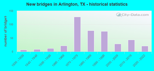
- New bridges - historical statistics
- 11920-1929
- 71930-1939
- 91940-1949
- 121950-1959
- 221960-1969
- 1281970-1979
- 781980-1989
- 751990-1999
- 292000-2009
- 442010-2019
- 212020-2022
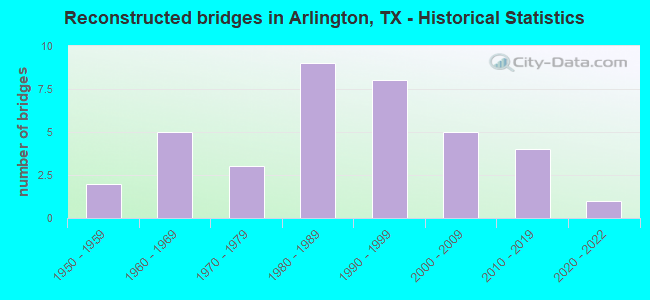
- Reconstructed bridges - Historical Statistics
- 21950-1959
- 51960-1969
- 31970-1979
- 91980-1989
- 81990-1999
- 52000-2009
- 42010-2019
- 12020-2022
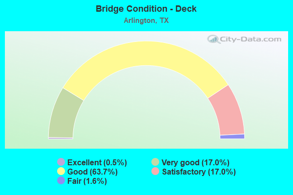
- Bridge Condition - Deck
- 0.5%Excellent
- 17.0%Very good
- 63.7%Good
- 17.0%Satisfactory
- 1.6%Fair
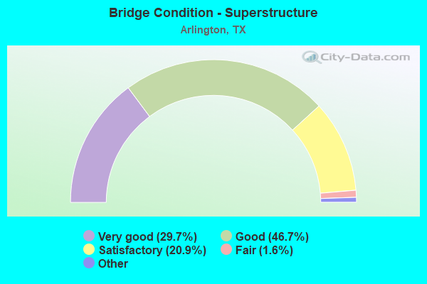
- Bridge Condition - Superstructure
- 29.7%Excellent
- 46.7%Very good
- 20.9%Good
- 1.6%Satisfactory
- 1.1%Fair
- 0.5%Poor
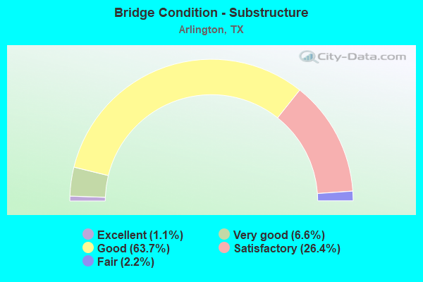
- Bridge Condition - Substructure
- 1.1%Excellent
- 6.6%Very good
- 63.7%Good
- 26.4%Satisfactory
- 2.2%Fair
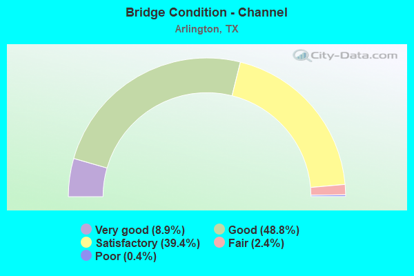
- Bridge Condition - Channel
- 8.9%Very good
- 48.8%Good
- 39.4%Satisfactory
- 2.4%Fair
- 0.4%Poor
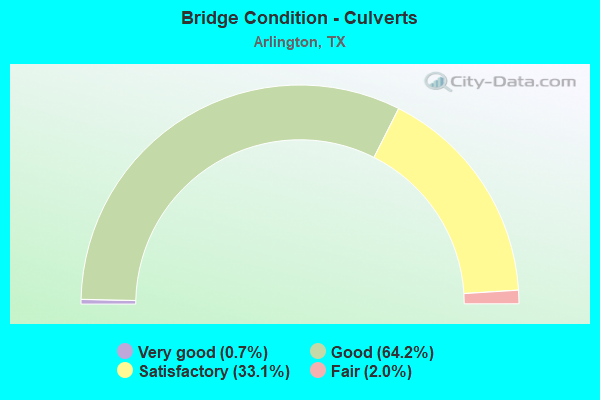
- Bridge Condition - Culverts
- 0.7%Very good
- 64.2%Good
- 33.1%Satisfactory
- 2.0%Fair
Find on map >> Show street view
Structure Number: 22200000806046, Location: 2.5 Mi E of IH 820 (Lat: 32.731233, Lng: -97.178933), Route carried "on" structure: State highway 180, Year Built: 1947, Year Reconstructed: 1960, Status: Open, Structure Length: 4.57m (14.99ft), Average Daily Traffic: 18,591 (year 2019), Truck Traffic: 5%, Average Future Daily Traffic: 24,190 (year 2035), Design Load: H 20, Features Intersected: Village Crk West Relief
Minimum Vertical Clearance: 30+ m (98+ ft), Kilometerpoint: 35.856, Lanes on structure: 4, Base Highway Network: Yes, Owner: State Highway Agency, Approaching Roadway Width: 19.5m (64.0ft), Material/Design: Concrete continuous, Design/Construction: Slab, Number Of Spans In Main Unit: 6, Length of Maximum Span: 7.6m (24.9ft), Curb-To-Curb Width: 15.4m (50.5ft), Out-to-Out Width: 16.8m (55.1ft)
Condition: Deck: Good, Superstructure: Good, Substructure: Good, Channel: Good, Operating Rating: 54.4 metric tons, Method Used To Determine Operating Rating: Load Factor (LF), Inventory Rating: 32.7 metric tons, Method Used To Determine Inventory Rating: Load Factor (LF), Structural Evaluation: Better than present minimum criteria, Deck Geometry: Meets minimum limits, Waterway Adequacy: Equal to present minimum criteria, Approach Roadway Alignment: Equal to present desirable criteria, Designated Inspection Frequency: Every 24 months, Inspection Date: May 2021, Deck Structure Type: Concrete Cast-file-Place, Wearing Surface/Protective System: Wearing Surface: Bituminous
Find on map >> Show street view
Structure Number: 22200000806052, Location: 2.8 Mi E of IH 820 (Lat: 32.731783, Lng: -97.175075), Route carried "on" structure: State highway 180, Year Built: 1947, Year Reconstructed: 1960, Status: Open, Structure Length: 4.57m (14.99ft), Average Daily Traffic: 18,591 (year 2019), Truck Traffic: 5%, Average Future Daily Traffic: 24,190 (year 2035), Design Load: H 20, Features Intersected: Village Crk East Relief
Minimum Vertical Clearance: 30+ m (98+ ft), Kilometerpoint: 36.252, Lanes on structure: 4, Base Highway Network: Yes, Owner: State Highway Agency, Approaching Roadway Width: 19.5m (64.0ft), Material/Design: Concrete continuous, Design/Construction: Slab, Number Of Spans In Main Unit: 6, Length of Maximum Span: 7.6m (24.9ft), Curb-To-Curb Width: 15.5m (50.9ft), Out-to-Out Width: 16.8m (55.1ft)
Condition: Deck: Satisfactory, Superstructure: Satisfactory, Substructure: Good, Channel: Good, Operating Rating: 53.5 metric tons, Method Used To Determine Operating Rating: Load Factor (LF), Inventory Rating: 32.7 metric tons, Method Used To Determine Inventory Rating: Load Factor (LF), Structural Evaluation: Equal to present minimum criteria, Deck Geometry: Meets minimum limits, Waterway Adequacy: Equal to present minimum criteria, Approach Roadway Alignment: Equal to present desirable criteria, Designated Inspection Frequency: Every 24 months, Inspection Date: May 2021, Deck Structure Type: Concrete Cast-file-Place, Wearing Surface/Protective System: Wearing Surface: Bituminous
Find on map >> Show street view
Structure Number: 22200000806053, Location: 3.1 Mi E of IH 820 (Lat: 32.732061, Lng: -97.169364), Route carried "on" structure: State highway 180, Year Built: 1947, Year Reconstructed: 1960, Status: Open, Structure Length: 5.49m (18.01ft), Average Daily Traffic: 18,591 (year 2019), Truck Traffic: 5%, Average Future Daily Traffic: 24,190 (year 2033), Design Load: H 20, Features Intersected: Rush Creek
Minimum Vertical Clearance: 30+ m (98+ ft), Kilometerpoint: 36.802, Lanes on structure: 4, Base Highway Network: Yes, Owner: State Highway Agency, Approaching Roadway Width: 19.5m (64.0ft), Material/Design: Concrete continuous, Design/Construction: Slab, Number Of Spans In Main Unit: 7, Length of Maximum Span: 9.1m (29.9ft), Curb-To-Curb Width: 15.5m (50.9ft), Out-to-Out Width: 16.8m (55.1ft)
Condition: Deck: Satisfactory, Superstructure: Satisfactory, Substructure: Satisfactory, Channel: Satisfactory, Operating Rating: 49.9 metric tons, Method Used To Determine Operating Rating: Load Factor (LF), Inventory Rating: 29.9 metric tons, Method Used To Determine Inventory Rating: Load Factor (LF), Structural Evaluation: Equal to present minimum criteria, Deck Geometry: Meets minimum limits, Waterway Adequacy: Equal to present minimum criteria, Approach Roadway Alignment: Equal to present desirable criteria, Designated Inspection Frequency: Every 24 months, Inspection Date: May 2021, Deck Structure Type: Concrete Cast-file-Place, Wearing Surface/Protective System: Wearing Surface: Bituminous
Find on map >> Show street view
Structure Number: 22200000806054, Location: 3.2 Mi E of IH 820 (Lat: 32.732172, Lng: -97.167614), Route carried "on" structure: State highway 180, Year Built: 1947, Year Reconstructed: 1960, Status: Open, Structure Length: 3.05m (10.01ft), Average Daily Traffic: 18,591 (year 2019), Truck Traffic: 5%, Average Future Daily Traffic: 24,190 (year 2035), Design Load: H 20, Features Intersected: Rush Creek Relief
Minimum Vertical Clearance: 30+ m (98+ ft), Kilometerpoint: 36.922, Lanes on structure: 4, Base Highway Network: Yes, Owner: State Highway Agency, Approaching Roadway Width: 19.5m (64.0ft), Material/Design: Concrete continuous, Design/Construction: Slab, Number Of Spans In Main Unit: 4, Length of Maximum Span: 7.6m (24.9ft), Curb-To-Curb Width: 15.5m (50.9ft), Out-to-Out Width: 16.8m (55.1ft)
Condition: Deck: Satisfactory, Superstructure: Satisfactory, Substructure: Fair, Channel: Satisfactory, Operating Rating: 54.4 metric tons, Method Used To Determine Operating Rating: Load Factor (LF), Inventory Rating: 32.7 metric tons, Method Used To Determine Inventory Rating: Load Factor (LF), Structural Evaluation: Somewhat better than minimum adequacy, Deck Geometry: Meets minimum limits, Waterway Adequacy: Equal to present minimum criteria, Approach Roadway Alignment: Equal to present desirable criteria, Designated Inspection Frequency: Every 24 months, Inspection Date: May 2021, Deck Structure Type: Concrete Cast-file-Place, Wearing Surface/Protective System: Wearing Surface: Bituminous
Find on map >> Show street view
Structure Number: 22200000806439, Location: 3.70 MI E of IH 820 (Lat: 32.734283, Lng: -97.162983), Route carried "on" structure: State highway 180, Year Built: 1994, Status: Open, Structure Length: 1.04m (3.41ft), Average Daily Traffic: 18,480 (year 2020), Truck Traffic: 3%, Average Future Daily Traffic: 25,872 (year 2040), Design Load: HS 20, Features Intersected: Trib Rush Creek
Minimum Vertical Clearance: 30+ m (98+ ft), Kilometerpoint: 37.488, Lanes on structure: 5, Owner: State Highway Agency, Approaching Roadway Width: 19.5m (64.0ft), Material/Design: Concrete, Design/Construction: Culvert, Number Of Spans In Main Unit: 4, Length of Maximum Span: 2.1m (6.9ft), Curb or Sidewalk Widths: Left: 1.7m (5.6ft), Right: 1.8m (5.9ft), Curb-To-Curb Width: 19.7m (64.6ft), Out-to-Out Width: 23.6m (77.4ft)
Condition: Channel: Good, Culverts: Satisfactory, Operating Rating: 44.4 metric tons, Method Used To Determine Operating Rating: No rating analysis performed, Inventory Rating: 32.7 metric tons, Method Used To Determine Inventory Rating: No rating analysis performed, Structural Evaluation: Equal to present minimum criteria, Deck Geometry: Meets minimum limits, Waterway Adequacy: Equal to present minimum criteria, Approach Roadway Alignment: Equal to present desirable criteria, Designated Inspection Frequency: Every 24 months, Inspection Date: October 2021, Deck Structure Type: Concrete Cast-file-Place, Wearing Surface/Protective System: Wearing Surface: Bituminous
Find on map >> Show street view
Structure Number: 22200000806483, Location: 2.7 MI. E. OF IH 280 (Lat: 32.731458, Lng: -97.177211), Route carried "on" structure: State highway 180, Year Built: 2011, Status: Open, Structure Length: 6.40m (21.00ft), Average Daily Traffic: 18,591 (year 2019), Truck Traffic: 5%, Average Future Daily Traffic: 24,190 (year 2035), Design Load: HL 93, Features Intersected: VILLAGE CREEK
Minimum Vertical Clearance: 30+ m (98+ ft), Kilometerpoint: 36.041, Lanes on structure: 4, Owner: State Highway Agency, Approaching Roadway Width: 19.5m (64.0ft), Skew: 1 degrees, Material/Design: Prestressed concrete, Design/Construction: Stringer/Multi-beam, Number Of Spans In Main Unit: 3, Length of Maximum Span: 21.3m (69.9ft), Curb-To-Curb Width: 20.4m (66.9ft), Out-to-Out Width: 21.3m (69.9ft)
Condition: Deck: Good, Superstructure: Very good, Substructure: Good, Channel: Good, Operating Rating: 54.4 metric tons, Method Used To Determine Operating Rating: Assigned ratings based on Load and Resistance Factor Design (LRFD) reported in metric tons, Inventory Rating: 32.7 metric tons, Method Used To Determine Inventory Rating: Assigned ratings based on Load and Resistance Factor Design (LRFD) reported in metric tons, Structural Evaluation: Better than present minimum criteria, Deck Geometry: Superior to present desirable criteria, Waterway Adequacy: Superior to present desirable criteria, Approach Roadway Alignment: Equal to present desirable criteria, Designated Inspection Frequency: Every 24 months, Inspection Date: May 2021, Deck Structure Type: Corrugated Steel, Wearing Surface/Protective System: Wearing Surface: Monolithic Concrete, Membrane: Other, Deck Protection: Epoxy Coated Reinforcing
Find on map >> Show street view
Structure Number: 22200000807022, Location: 1.6 MI W OF SH 360 (Lat: 32.740981, Lng: -97.087664), Route carried "on" structure: State highway 180, Year Built: 1921, Year Reconstructed: 1961, Status: Open, Structure Length: 2.83m (9.28ft), Average Daily Traffic: 15,223 (year 2020), Truck Traffic: 5%, Average Future Daily Traffic: 22,050 (year 2035), Design Load: H 15, Features Intersected: JOHNSON CREEK
Minimum Vertical Clearance: 30+ m (98+ ft), Kilometerpoint: 44.687, Lanes on structure: 5, Base Highway Network: Yes, Owner: State Highway Agency, Approaching Roadway Width: 20.7m (67.9ft), Material/Design: Concrete, Design/Construction: Tee Beam, Number Of Spans In Main Unit: 3, Length of Maximum Span: 9.4m (30.8ft), Curb-To-Curb Width: 19.6m (64.3ft), Out-to-Out Width: 21.4m (70.2ft)
Condition: Deck: Satisfactory, Superstructure: Satisfactory, Substructure: Fair, Channel: Satisfactory, Operating Rating: 54.4 metric tons, Method Used To Determine Operating Rating: Load Factor (LF), Inventory Rating: 32.7 metric tons, Method Used To Determine Inventory Rating: Load Factor (LF), Structural Evaluation: Somewhat better than minimum adequacy, Deck Geometry: Meets minimum limits, Waterway Adequacy: High priority of corrective action, Approach Roadway Alignment: Equal to present desirable criteria, Length Of Structure Improvement: 2.23m (7.32ft), Designated Inspection Frequency: Every 24 months, Inspection Date: May 2021, Deck Structure Type: Concrete Cast-file-Place, Wearing Surface/Protective System: Wearing Surface: Bituminous
Find on map >> Show street view
Structure Number: 22200000807292, Location: 6.1 MI. FROM JCT. IH 820 (Lat: 32.736428, Lng: -97.131567), Route carried "on" structure: City street 666, Year Built: 1977, Status: Open, Structure Length: 12.95m (42.49ft), Average Daily Traffic: 23,480 (year 2015), Average Future Daily Traffic: 23,530 (year 2035), Design Load: HS 20, Features Intersected: SH 180, Facility Carried by Structure: FIELDER ROAD
Minimum Vertical Clearance: 30+ m (98+ ft), Kilometerpoint: 9.857, Lanes on structure: 4, Lanes under structure: 9, Owner: State Highway Agency, Approaching Roadway Width: 14.6m (47.9ft), Skew: 29 degrees, Material/Design: Prestressed concrete, Design/Construction: Stringer/Multi-beam, Number Of Spans In Main Unit: 3, Number Of Approach Spans: 2, Length of Maximum Span: 35.4m (116.1ft), Curb or Sidewalk Widths: Left: 0.8m (2.6ft), Right: 1.8m (5.9ft), Curb-To-Curb Width: 14.6m (47.9ft), Out-to-Out Width: 19.0m (62.3ft)
Condition: Deck: Good, Superstructure: Good, Substructure: Satisfactory, Operating Rating: 54.4 metric tons, Method Used To Determine Operating Rating: Assigned rating based on Load Factor Design (LFD) reported in metric tons, Inventory Rating: 32.7 metric tons, Method Used To Determine Inventory Rating: Assigned rating based on Load Factor Design (LFD) reported in metric tons, Structural Evaluation: Equal to present minimum criteria, Deck Geometry: High priority of replacement, Underclear: Equal to present minimum criteria, Approach Roadway Alignment: Equal to present desirable criteria, Designated Inspection Frequency: Every 24 months, Inspection Date: May 2021, Deck Structure Type: Concrete Cast-file-Place, Wearing Surface/Protective System: Wearing Surface: Bituminous
Find on map >> Show street view
Structure Number: 22200000807444, Location: 2.0 MI E OF FM 157 (Lat: 32.742858, Lng: -97.061661), Route carried "on" structure: State highway 180, Year Built: 2010, Status: Open, Structure Length: 14.63m (48.00ft), Average Daily Traffic: 16,536 (year 2018), Truck Traffic: 5%, Average Future Daily Traffic: 12,270 (year 2035), Design Load: HL 93, Features Intersected: SH 360
Minimum Vertical Clearance: 30+ m (98+ ft), Kilometerpoint: 47.027, Lanes on structure: 3, Lanes under structure: 13, Owner: State Highway Agency, Approaching Roadway Width: 12.2m (40.0ft), Skew: 1 degrees, Material/Design: Prestressed concrete, Design/Construction: Stringer/Multi-beam, Number Of Spans In Main Unit: 4, Length of Maximum Span: 36.6m (120.1ft), Curb-To-Curb Width: 12.1m (39.7ft), Out-to-Out Width: 12.8m (42.0ft)
Condition: Deck: Very good, Superstructure: Good, Substructure: Good, Operating Rating: 54.4 metric tons, Method Used To Determine Operating Rating: Assigned ratings based on Load and Resistance Factor Design (LRFD) reported in metric tons, Inventory Rating: 32.7 metric tons, Method Used To Determine Inventory Rating: Assigned ratings based on Load and Resistance Factor Design (LRFD) reported in metric tons, Structural Evaluation: Better than present minimum criteria, Deck Geometry: Meets minimum limits, Underclear: Better than present minimum criteria, Approach Roadway Alignment: Equal to present desirable criteria, Designated Inspection Frequency: Every 24 months, Inspection Date: May 2021, Deck Structure Type: Concrete Precast Panels, Wearing Surface/Protective System: Membrane: Other, Deck Protection: Epoxy Coated Reinforcing
Find on map >> Show street view
Structure Number: 22200000807445, Location: 2.0 MI E OF FM 157 (Lat: 32.742872, Lng: -97.063236), Route carried "on" structure: State highway 180, Year Built: 2010, Status: Open, Structure Length: 14.63m (48.00ft), Average Daily Traffic: 16,536 (year 2018), Truck Traffic: 4%, Average Future Daily Traffic: 16,600 (year 2035), Design Load: HL 93, Features Intersected: SH 360
Minimum Vertical Clearance: 30+ m (98+ ft), Kilometerpoint: 47.027, Lanes on structure: 3, Lanes under structure: 13, Owner: State Highway Agency, Approaching Roadway Width: 12.2m (40.0ft), Skew: 1 degrees, Material/Design: Prestressed concrete, Design/Construction: Stringer/Multi-beam, Number Of Spans In Main Unit: 4, Length of Maximum Span: 36.6m (120.1ft), Curb-To-Curb Width: 12.1m (39.7ft), Out-to-Out Width: 12.8m (42.0ft)
Condition: Deck: Good, Superstructure: Good, Substructure: Good, Operating Rating: 54.4 metric tons, Method Used To Determine Operating Rating: Assigned ratings based on Load and Resistance Factor Design (LRFD) reported in metric tons, Inventory Rating: 32.7 metric tons, Method Used To Determine Inventory Rating: Assigned ratings based on Load and Resistance Factor Design (LRFD) reported in metric tons, Structural Evaluation: Better than present minimum criteria, Deck Geometry: Meets minimum limits, Underclear: Better than present minimum criteria, Approach Roadway Alignment: Equal to present desirable criteria, Designated Inspection Frequency: Every 24 months, Inspection Date: May 2021, Deck Structure Type: Concrete Precast Panels, Wearing Surface/Protective System: Membrane: Other, Deck Protection: Epoxy Coated Reinforcing
Find on map >> Show street view
Structure Number: 22200017209126, Location: 0.30 MI S OF IH 20 (Lat: 32.668161, Lng: -97.204200), Route carried "on" structure: US 287, Year Built: 1973, Status: Open, Structure Length: 7.77m (25.49ft), Average Daily Traffic: 37,312 (year 2019), Truck Traffic: 9%, Average Future Daily Traffic: 50,930 (year 2033), Design Load: HS 20, Features Intersected: KENN-LITTLE SCHL RD
Minimum Vertical Clearance: 30+ m (98+ ft), Kilometerpoint: 33.375, Lanes on structure: 2, Lanes under structure: 7, Base Highway Network: Yes, Owner: State Highway Agency, Approaching Roadway Width: 12.8m (42.0ft), Skew: 1 degrees, Material/Design: Prestressed concrete, Design/Construction: Stringer/Multi-beam, Number Of Spans In Main Unit: 3, Number Of Approach Spans: 1, Length of Maximum Span: 22.9m (75.1ft), Curb-To-Curb Width: 12.8m (42.0ft), Out-to-Out Width: 13.3m (43.6ft)
Condition: Deck: Very good, Superstructure: Good, Substructure: Good, Operating Rating: 54.4 metric tons, Method Used To Determine Operating Rating: Assigned rating based on Load Factor Design (LFD) reported in metric tons, Inventory Rating: 32.7 metric tons, Method Used To Determine Inventory Rating: Assigned rating based on Load Factor Design (LFD) reported in metric tons, Structural Evaluation: Better than present minimum criteria, Deck Geometry: Equal to present desirable criteria, Underclear: Equal to present minimum criteria, Approach Roadway Alignment: Equal to present desirable criteria, Designated Inspection Frequency: Every 24 months, Inspection Date: June 2021, Deck Structure Type: Concrete Cast-file-Place, Wearing Surface/Protective System: Wearing Surface: Bituminous
Find on map >> Show street view
Structure Number: 22200017209127, Location: 0.30 MI S OF IH 20 (Lat: 32.667511, Lng: -97.204700), Route carried "on" structure: US 287, Year Built: 1973, Status: Open, Structure Length: 8.23m (27.00ft), Average Daily Traffic: 37,792 (year 2019), Truck Traffic: 9%, Average Future Daily Traffic: 50,930 (year 2033), Design Load: HS 20, Features Intersected: KENN-LITTLE SCHL RD
Minimum Vertical Clearance: 30+ m (98+ ft), Kilometerpoint: 33.394, Lanes on structure: 3, Lanes under structure: 7, Base Highway Network: Yes, Owner: State Highway Agency, Approaching Roadway Width: 15.9m (52.2ft), Skew: 9 degrees, Material/Design: Prestressed concrete, Design/Construction: Stringer/Multi-beam, Number Of Spans In Main Unit: 3, Number Of Approach Spans: 1, Length of Maximum Span: 25.3m (83.0ft), Curb-To-Curb Width: 15.9m (52.2ft), Out-to-Out Width: 16.5m (54.1ft)
Condition: Deck: Very good, Superstructure: Good, Substructure: Good, Operating Rating: 54.4 metric tons, Method Used To Determine Operating Rating: Assigned rating based on Load Factor Design (LFD) reported in metric tons, Inventory Rating: 32.7 metric tons, Method Used To Determine Inventory Rating: Assigned rating based on Load Factor Design (LFD) reported in metric tons, Structural Evaluation: Better than present minimum criteria, Deck Geometry: Somewhat better than minimum adequacy, Underclear: Better than present minimum criteria, Approach Roadway Alignment: Equal to present desirable criteria, Designated Inspection Frequency: Every 24 months, Inspection Date: June 2021, Deck Structure Type: Concrete Cast-file-Place, Wearing Surface/Protective System: Wearing Surface: Bituminous
Find on map >> Show street view
Structure Number: 22200017209128, Location: 1.1 MI S OF IH 20 (Lat: 32.657867, Lng: -97.195378), Route carried "on" structure: US 287, Year Built: 1973, Status: Open, Structure Length: 0.91m (2.99ft), Average Daily Traffic: 75,104 (year 2019), Truck Traffic: 9%, Average Future Daily Traffic: 101,860 (year 2033), Design Load: HS 20, Features Intersected: TRIB TO KEE BRANCH
Minimum Vertical Clearance: 30+ m (98+ ft), Kilometerpoint: 34.839, Lanes on structure: 6, Base Highway Network: Yes, Owner: State Highway Agency, Approaching Roadway Width: 33.5m (109.9ft), Skew: 1 degrees, Material/Design: Concrete, Design/Construction: Culvert, Number Of Spans In Main Unit: 3, Length of Maximum Span: 2.7m (8.9ft)
Condition: Channel: Fair, Culverts: Satisfactory, Operating Rating: 39.9 metric tons, Method Used To Determine Operating Rating: Load Factor (LF), Inventory Rating: 23.6 metric tons, Method Used To Determine Inventory Rating: Load Factor (LF), Structural Evaluation: Somewhat better than minimum adequacy, Waterway Adequacy: Equal to present minimum criteria, Approach Roadway Alignment: Equal to present desirable criteria, Designated Inspection Frequency: Every 24 months, Inspection Date: June 2021
Find on map >> Show street view
Structure Number: 22200017209129, Location: 1.1 MI S OF IH 20 (Lat: 32.658214, Lng: -97.194372), Route carried "on" structure: ServiceUS 287, Year Built: 1973, Status: Open, Structure Length: 0.88m (2.89ft), Average Daily Traffic: 2,794 (year 2019), Truck Traffic: 9%, Average Future Daily Traffic: 1,900 (year 2033), Design Load: HS 20, Features Intersected: TRIB. KEE BRANCH
Minimum Vertical Clearance: 30+ m (98+ ft), Kilometerpoint: 34.839, Lanes on structure: 2, Owner: State Highway Agency, Approaching Roadway Width: 9.8m (32.2ft), Material/Design: Concrete, Design/Construction: Culvert, Number Of Spans In Main Unit: 3, Length of Maximum Span: 2.7m (8.9ft), Curb-To-Curb Width: 11.4m (37.4ft), Out-to-Out Width: 14.2m (46.6ft)
Condition: Channel: Fair, Culverts: Good, Operating Rating: 39.9 metric tons, Method Used To Determine Operating Rating: Load Factor (LF), Inventory Rating: 23.6 metric tons, Method Used To Determine Inventory Rating: Load Factor (LF), Structural Evaluation: Equal to present minimum criteria, Deck Geometry: Equal to present minimum criteria, Waterway Adequacy: Equal to present minimum criteria, Approach Roadway Alignment: Equal to present desirable criteria, Designated Inspection Frequency: Every 24 months, Inspection Date: June 2021, Deck Structure Type: Concrete Cast-file-Place, Wearing Surface/Protective System: Wearing Surface: Bituminous
Find on map >> Show street view
Structure Number: 2220001720913, Location: 1.3 MI S OF IH 20 (Lat: 32.656400, Lng: -97.193703), Route carried "on" structure: US 287, Year Built: 1973, Status: Open, Structure Length: 1.22m (4.00ft), Average Daily Traffic: 61,000 (year 2020), Truck Traffic: 9%, Average Future Daily Traffic: 101,860 (year 2033), Design Load: HS 20, Features Intersected: TRIB. KEE BRANCH
Minimum Vertical Clearance: 30+ m (98+ ft), Kilometerpoint: 35.032, Lanes on structure: 4, Base Highway Network: Yes, Owner: State Highway Agency, Approaching Roadway Width: 23.2m (76.1ft), Skew: 3 degrees, Material/Design: Concrete, Design/Construction: Culvert, Number Of Spans In Main Unit: 4, Length of Maximum Span: 2.4m (7.9ft)
Condition: Channel: Satisfactory, Culverts: Satisfactory, Operating Rating: 39.9 metric tons, Method Used To Determine Operating Rating: Load Factor (LF), Inventory Rating: 23.6 metric tons, Method Used To Determine Inventory Rating: Load Factor (LF), Structural Evaluation: Somewhat better than minimum adequacy, Waterway Adequacy: Equal to present minimum criteria, Approach Roadway Alignment: Equal to present desirable criteria, Designated Inspection Frequency: Every 24 months, Inspection Date: June 2021
Find on map >> Show street view
Structure Number: 22200017209131, Location: 1.3 MI S OF IH 20 (Lat: 32.656108, Lng: -97.193864), Route carried "on" structure: ServiceUS 287, Year Built: 1973, Status: Open, Structure Length: 1.22m (4.00ft), Average Daily Traffic: 2,200 (year 2019), Truck Traffic: 9%, Average Future Daily Traffic: 1,370 (year 2033), Design Load: HS 20, Features Intersected: TRIB. KEE BRANCH
Minimum Vertical Clearance: 30+ m (98+ ft), Kilometerpoint: 35.045, Lanes on structure: 2, Owner: State Highway Agency, Approaching Roadway Width: 9.1m (29.9ft), Skew: 3 degrees, Material/Design: Concrete, Design/Construction: Culvert, Number Of Spans In Main Unit: 4, Length of Maximum Span: 2.4m (7.9ft)
Condition: Channel: Satisfactory, Culverts: Satisfactory, Operating Rating: 39.9 metric tons, Method Used To Determine Operating Rating: Load Factor (LF), Inventory Rating: 23.6 metric tons, Method Used To Determine Inventory Rating: Load Factor (LF), Structural Evaluation: Equal to present minimum criteria, Waterway Adequacy: Equal to present minimum criteria, Approach Roadway Alignment: Equal to present desirable criteria, Designated Inspection Frequency: Every 24 months, Inspection Date: June 2021
Find on map >> Show street view
Structure Number: 22200017209132, Location: 1.2 MI S OF IH 20 (Lat: 32.656775, Lng: -97.193458), Route carried "on" structure: ServiceUS 287, Year Built: 1973, Status: Open, Structure Length: 1.52m (4.99ft), Average Daily Traffic: 1,350 (year 2013), Truck Traffic: 9%, Average Future Daily Traffic: 1,900 (year 2033), Design Load: HS 20, Features Intersected: TRIB KEE BRANCH
Minimum Vertical Clearance: 30+ m (98+ ft), Kilometerpoint: 35.016, Lanes on structure: 2, Owner: State Highway Agency, Approaching Roadway Width: 9.1m (29.9ft), Skew: 3 degrees, Material/Design: Concrete, Design/Construction: Culvert, Number Of Spans In Main Unit: 4, Length of Maximum Span: 3.0m (9.8ft), Curb-To-Curb Width: 11.6m (38.1ft), Out-to-Out Width: 16.0m (52.5ft)
Condition: Channel: Satisfactory, Culverts: Satisfactory, Operating Rating: 39.9 metric tons, Method Used To Determine Operating Rating: Load Factor (LF), Inventory Rating: 23.6 metric tons, Method Used To Determine Inventory Rating: Load Factor (LF), Structural Evaluation: Equal to present minimum criteria, Deck Geometry: Equal to present minimum criteria, Waterway Adequacy: Equal to present minimum criteria, Approach Roadway Alignment: Equal to present desirable criteria, Designated Inspection Frequency: Every 24 months, Inspection Date: June 2021, Deck Structure Type: Concrete Cast-file-Place, Wearing Surface/Protective System: Wearing Surface: Bituminous
Find on map >> Show street view
Structure Number: 22200017209133, Location: 1.7 MI S OF IH 20 (Lat: 32.650483, Lng: -97.188850), Route carried "on" structure: US 287, Year Built: 1973, Status: Open, Structure Length: 0.70m (2.30ft), Average Daily Traffic: 61,000 (year 2020), Truck Traffic: 9%, Average Future Daily Traffic: 101,860 (year 2033), Design Load: HS 20, Features Intersected: KEE BRANCH TRIB
Minimum Vertical Clearance: 30+ m (98+ ft), Kilometerpoint: 35.816, Lanes on structure: 8, Base Highway Network: Yes, Owner: State Highway Agency, Approaching Roadway Width: 43.9m (144.0ft), Skew: 3 degrees, Material/Design: Concrete, Design/Construction: Culvert, Number Of Spans In Main Unit: 3, Length of Maximum Span: 1.8m (5.9ft)
Condition: Channel: Satisfactory, Culverts: Good, Operating Rating: 39.9 metric tons, Method Used To Determine Operating Rating: Load Factor (LF), Inventory Rating: 23.6 metric tons, Method Used To Determine Inventory Rating: Load Factor (LF), Structural Evaluation: Somewhat better than minimum adequacy, Waterway Adequacy: Equal to present minimum criteria, Approach Roadway Alignment: Equal to present desirable criteria, Designated Inspection Frequency: Every 24 months, Inspection Date: June 2021
Find on map >> Show street view
Structure Number: 22200017209134, Location: 4.0 MI N OF FM 157 (Lat: 32.646269, Lng: -97.185125), Route carried "on" structure: US 287, Year Built: 1973, Status: Open, Structure Length: 8.23m (27.00ft), Average Daily Traffic: 37,312 (year 2019), Truck Traffic: 9%, Average Future Daily Traffic: 50,930 (year 2033), Design Load: HS 20, Features Intersected: KENN-SUBLETT RD
Minimum Vertical Clearance: 30+ m (98+ ft), Kilometerpoint: 36.399, Lanes on structure: 2, Lanes under structure: 7, Owner: State Highway Agency, Approaching Roadway Width: 12.8m (42.0ft), Skew: 2 degrees, Material/Design: Prestressed concrete, Design/Construction: Stringer/Multi-beam, Number Of Spans In Main Unit: 1, Number Of Approach Spans: 2, Length of Maximum Span: 36.6m (120.1ft), Curb-To-Curb Width: 12.8m (42.0ft), Out-to-Out Width: 13.4m (44.0ft)
Condition: Deck: Good, Superstructure: Satisfactory, Substructure: Satisfactory, Operating Rating: 54.4 metric tons, Method Used To Determine Operating Rating: Assigned rating based on Load Factor Design (LFD) reported in metric tons, Inventory Rating: 32.7 metric tons, Method Used To Determine Inventory Rating: Assigned rating based on Load Factor Design (LFD) reported in metric tons, Structural Evaluation: Equal to present minimum criteria, Deck Geometry: Equal to present desirable criteria, Underclear: Better than present minimum criteria, Approach Roadway Alignment: Equal to present desirable criteria, Designated Inspection Frequency: Every 24 months, Inspection Date: June 2021, Deck Structure Type: Concrete Cast-file-Place, Wearing Surface/Protective System: Wearing Surface: Bituminous
Find on map >> Show street view
Structure Number: 22200017209135, Location: 4.0 MI N OF FM 157 (Lat: 32.646258, Lng: -97.185228), Route carried "on" structure: US 287, Year Built: 1973, Status: Open, Structure Length: 8.23m (27.00ft), Average Daily Traffic: 37,792 (year 2019), Truck Traffic: 9%, Average Future Daily Traffic: 50,930 (year 2033), Design Load: HS 20, Features Intersected: KENN-SUBLETT RD
Minimum Vertical Clearance: 30+ m (98+ ft), Kilometerpoint: 36.382, Lanes on structure: 2, Lanes under structure: 7, Base Highway Network: Yes, Owner: State Highway Agency, Approaching Roadway Width: 12.8m (42.0ft), Skew: 2 degrees, Material/Design: Prestressed concrete, Design/Construction: Stringer/Multi-beam, Number Of Spans In Main Unit: 1, Number Of Approach Spans: 2, Length of Maximum Span: 36.6m (120.1ft), Curb-To-Curb Width: 12.8m (42.0ft), Out-to-Out Width: 13.4m (44.0ft)
Condition: Deck: Good, Superstructure: Good, Substructure: Satisfactory, Operating Rating: 54.4 metric tons, Method Used To Determine Operating Rating: Assigned rating based on Load Factor Design (LFD) reported in metric tons, Inventory Rating: 32.7 metric tons, Method Used To Determine Inventory Rating: Assigned rating based on Load Factor Design (LFD) reported in metric tons, Structural Evaluation: Equal to present minimum criteria, Deck Geometry: Equal to present desirable criteria, Underclear: Superior to present desirable criteria, Approach Roadway Alignment: Equal to present desirable criteria, Designated Inspection Frequency: Every 24 months, Inspection Date: June 2021, Deck Structure Type: Concrete Cast-file-Place, Wearing Surface/Protective System: Wearing Surface: Bituminous
Find on map >> Show street view
Structure Number: 22200017209136, Location: 3.0 MI N OF FM 157 (Lat: 32.633436, Lng: -97.176489), Route carried "on" structure: US 287, Year Built: 1973, Status: Open, Structure Length: 7.47m (24.51ft), Average Daily Traffic: 33,898 (year 2019), Truck Traffic: 9%, Average Future Daily Traffic: 50,930 (year 2033), Design Load: HS 20, Features Intersected: EDEN RD
Minimum Vertical Clearance: 30+ m (98+ ft), Kilometerpoint: 38.029, Lanes on structure: 2, Lanes under structure: 4, Owner: State Highway Agency, Approaching Roadway Width: 12.8m (42.0ft), Skew: 1 degrees, Material/Design: Prestressed concrete, Design/Construction: Stringer/Multi-beam, Number Of Spans In Main Unit: 1, Number Of Approach Spans: 2, Length of Maximum Span: 32.9m (107.9ft), Curb-To-Curb Width: 12.8m (42.0ft), Out-to-Out Width: 13.4m (44.0ft)
Condition: Deck: Good, Superstructure: Good, Substructure: Satisfactory, Operating Rating: 54.4 metric tons, Method Used To Determine Operating Rating: Assigned rating based on Load Factor Design (LFD) reported in metric tons, Inventory Rating: 32.7 metric tons, Method Used To Determine Inventory Rating: Assigned rating based on Load Factor Design (LFD) reported in metric tons, Structural Evaluation: Equal to present minimum criteria, Deck Geometry: Equal to present desirable criteria, Underclear: Superior to present desirable criteria, Approach Roadway Alignment: Equal to present desirable criteria, Designated Inspection Frequency: Every 24 months, Inspection Date: June 2021, Deck Structure Type: Concrete Cast-file-Place, Wearing Surface/Protective System: Wearing Surface: Bituminous
Find on map >> Show street view
Structure Number: 22200017209137, Location: 3.0 MI N OF FM 157 (Lat: 32.633414, Lng: -97.176594), Route carried "on" structure: US 287, Year Built: 1973, Status: Open, Structure Length: 7.47m (24.51ft), Average Daily Traffic: 33,406 (year 2019), Truck Traffic: 9%, Average Future Daily Traffic: 50,930 (year 2033), Design Load: HS 20, Features Intersected: EDEN RD
Minimum Vertical Clearance: 30+ m (98+ ft), Kilometerpoint: 38.013, Lanes on structure: 2, Lanes under structure: 4, Owner: State Highway Agency, Approaching Roadway Width: 12.5m (41.0ft), Skew: 1 degrees, Material/Design: Prestressed concrete, Design/Construction: Stringer/Multi-beam, Number Of Spans In Main Unit: 1, Number Of Approach Spans: 2, Length of Maximum Span: 32.9m (107.9ft), Curb-To-Curb Width: 12.8m (42.0ft), Out-to-Out Width: 13.4m (44.0ft)
Condition: Deck: Good, Superstructure: Good, Substructure: Satisfactory, Operating Rating: 54.4 metric tons, Method Used To Determine Operating Rating: Assigned rating based on Load Factor Design (LFD) reported in metric tons, Inventory Rating: 32.7 metric tons, Method Used To Determine Inventory Rating: Assigned rating based on Load Factor Design (LFD) reported in metric tons, Structural Evaluation: Equal to present minimum criteria, Deck Geometry: Equal to present desirable criteria, Underclear: Better than present minimum criteria, Approach Roadway Alignment: Equal to present desirable criteria, Designated Inspection Frequency: Every 24 months, Inspection Date: June 2021, Deck Structure Type: Concrete Cast-file-Place, Wearing Surface/Protective System: Wearing Surface: Bituminous
Find on map >> Show street view
Structure Number: 22200017209138, Location: 2.8 MI N OF FM 157 (Lat: 32.632147, Lng: -97.175947), Route carried "on" structure: US 287, Year Built: 1973, Status: Open, Structure Length: 2.32m (7.61ft), Average Daily Traffic: 51,467 (year 2020), Truck Traffic: 10%, Average Future Daily Traffic: 83,560 (year 2033), Design Load: HS 20, Features Intersected: RUSH CREEK
Minimum Vertical Clearance: 30+ m (98+ ft), Kilometerpoint: 38.196, Lanes on structure: 8, Base Highway Network: Yes, Owner: State Highway Agency, Approaching Roadway Width: 49.6m (162.7ft), Skew: 3 degrees, Material/Design: Concrete, Design/Construction: Culvert, Number Of Spans In Main Unit: 6, Length of Maximum Span: 3.0m (9.8ft)
Condition: Channel: Satisfactory, Culverts: Satisfactory, Operating Rating: 39.9 metric tons, Method Used To Determine Operating Rating: Load Factor (LF), Inventory Rating: 23.6 metric tons, Method Used To Determine Inventory Rating: Load Factor (LF), Structural Evaluation: Somewhat better than minimum adequacy, Waterway Adequacy: Equal to present minimum criteria, Approach Roadway Alignment: Equal to present desirable criteria, Designated Inspection Frequency: Every 24 months, Inspection Date: June 2021
Find on map >> Show street view
Structure Number: 22200017209139, Location: 2.45 MI N OF FM 157 (Lat: 32.626475, Lng: -97.171233), Route carried "on" structure: City street , Year Built: 1973, Status: Open, Structure Length: 14.17m (46.49ft), Average Daily Traffic: 2,019 (year 2019), Truck Traffic: 1%, Average Future Daily Traffic: 2,170 (year 2029), Design Load: HS 20, Features Intersected: US 287, Facility Carried by Structure: RUSSELL CURRY RD
Minimum Vertical Clearance: 30+ m (98+ ft), Kilometerpoint: 0.641, Lanes on structure: 2, Lanes under structure: 4, Owner: State Highway Agency, Approaching Roadway Width: 14.6m (47.9ft), Skew: 5 degrees, Material/Design: Steel continuous, Design/Construction: Stringer/Multi-beam, Number Of Spans In Main Unit: 4, Length of Maximum Span: 47.2m (154.9ft), Curb-To-Curb Width: 14.3m (46.9ft), Out-to-Out Width: 15.2m (49.9ft)
Condition: Deck: Good, Superstructure: Satisfactory, Substructure: Good, Operating Rating: 62.6 metric tons, Method Used To Determine Operating Rating: Load Factor (LF), Inventory Rating: 37.2 metric tons, Method Used To Determine Inventory Rating: Load Factor (LF), Structural Evaluation: Equal to present minimum criteria, Deck Geometry: Superior to present desirable criteria, Underclear: Equal to present minimum criteria, Approach Roadway Alignment: Equal to present desirable criteria, Designated Inspection Frequency: Every 24 months, Inspection Date: June 2021, Deck Structure Type: Concrete Cast-file-Place, Wearing Surface/Protective System: Wearing Surface: Bituminous
Find on map >> Show street view
Structure Number: 2220001720914, Location: 1.4 MI N OF FM 157 (Lat: 32.614033, Lng: -97.160819), Route carried "on" structure: US 287, Year Built: 1973, Status: Open, Structure Length: 8.08m (26.51ft), Average Daily Traffic: 33,898 (year 2019), Truck Traffic: 10%, Average Future Daily Traffic: 41,780 (year 2033), Design Load: HS 20, Features Intersected: TURNER-WARNELL RD
Minimum Vertical Clearance: 30+ m (98+ ft), Kilometerpoint: 40.644, Lanes on structure: 2, Lanes under structure: 4, Base Highway Network: Yes, Owner: State Highway Agency, Approaching Roadway Width: 12.8m (42.0ft), Skew: 3 degrees, Material/Design: Prestressed concrete, Design/Construction: Stringer/Multi-beam, Number Of Spans In Main Unit: 1, Number Of Approach Spans: 2, Length of Maximum Span: 32.9m (107.9ft), Curb-To-Curb Width: 12.8m (42.0ft), Out-to-Out Width: 13.4m (44.0ft)
Condition: Deck: Good, Superstructure: Good, Substructure: Good, Operating Rating: 54.4 metric tons, Method Used To Determine Operating Rating: Assigned rating based on Load Factor Design (LFD) reported in metric tons, Inventory Rating: 32.7 metric tons, Method Used To Determine Inventory Rating: Assigned rating based on Load Factor Design (LFD) reported in metric tons, Structural Evaluation: Better than present minimum criteria, Deck Geometry: Equal to present desirable criteria, Underclear: Better than present minimum criteria, Approach Roadway Alignment: Equal to present desirable criteria, Designated Inspection Frequency: Every 24 months, Inspection Date: June 2021, Deck Structure Type: Concrete Cast-file-Place, Wearing Surface/Protective System: Wearing Surface: Bituminous
Find on map >> Show street view
Structure Number: 22200017209141, Location: 1.4 MI N OF FM 157 (Lat: 32.614311, Lng: -97.161528), Route carried "on" structure: US 287, Year Built: 1973, Status: Open, Structure Length: 8.08m (26.51ft), Average Daily Traffic: 33,406 (year 2019), Truck Traffic: 10%, Average Future Daily Traffic: 41,780 (year 2033), Design Load: HS 20, Features Intersected: TURNER-WARNELL RD
Minimum Vertical Clearance: 30+ m (98+ ft), Kilometerpoint: 40.626, Lanes on structure: 2, Lanes under structure: 4, Base Highway Network: Yes, Owner: State Highway Agency, Approaching Roadway Width: 14.6m (47.9ft), Skew: 3 degrees, Material/Design: Prestressed concrete, Design/Construction: Stringer/Multi-beam, Number Of Spans In Main Unit: 1, Number Of Approach Spans: 2, Length of Maximum Span: 32.9m (107.9ft), Curb-To-Curb Width: 12.8m (42.0ft), Out-to-Out Width: 13.4m (44.0ft)
Condition: Deck: Good, Superstructure: Good, Substructure: Good, Operating Rating: 54.4 metric tons, Method Used To Determine Operating Rating: Assigned rating based on Load Factor Design (LFD) reported in metric tons, Inventory Rating: 32.7 metric tons, Method Used To Determine Inventory Rating: Assigned rating based on Load Factor Design (LFD) reported in metric tons, Structural Evaluation: Better than present minimum criteria, Deck Geometry: Equal to present desirable criteria, Underclear: Superior to present desirable criteria, Approach Roadway Alignment: Equal to present desirable criteria, Designated Inspection Frequency: Every 24 months, Inspection Date: June 2021, Deck Structure Type: Concrete Cast-file-Place, Wearing Surface/Protective System: Wearing Surface: Bituminous
Find on map >> Show street view
Structure Number: 22200074703044, Location: 3.00 MI S OF SH 10 (Lat: 32.785903, Lng: -97.095856), Route carried "on" structure: State highway 157, Year Built: 1985, Year Reconstructed: 2003, Status: Open, Structure Length: 7.47m (24.51ft), Average Daily Traffic: 21,301 (year 2019), Truck Traffic: 3%, Average Future Daily Traffic: 46,670 (year 2033), Design Load: HS 20, Features Intersected: W FK TRINITY RIVER
Minimum Vertical Clearance: 30+ m (98+ ft), Kilometerpoint: 16.732, Lanes on structure: 6, Base Highway Network: Yes, Owner: State Highway Agency, Approaching Roadway Width: 24.4m (80.1ft), Skew: 20 degrees, Material/Design: Prestressed concrete, Design/Construction: Stringer/Multi-beam, Number Of Spans In Main Unit: 1, Number Of Approach Spans: 2, Length of Maximum Span: 32.0m (105.0ft), Curb or Sidewalk Widths: Left: 2.1m (6.9ft), Right: 3.9m (12.8ft), Curb-To-Curb Width: 24.4m (80.1ft), Out-to-Out Width: 37.8m (124.0ft)
Condition: Deck: Good, Superstructure: Very good, Substructure: Satisfactory, Channel: Satisfactory, Operating Rating: 54.4 metric tons, Method Used To Determine Operating Rating: Assigned rating based on Load Factor Design (LFD) reported in metric tons, Inventory Rating: 32.7 metric tons, Method Used To Determine Inventory Rating: Assigned rating based on Load Factor Design (LFD) reported in metric tons, Structural Evaluation: Equal to present minimum criteria, Deck Geometry: Somewhat better than minimum adequacy, Waterway Adequacy: Superior to present desirable criteria, Approach Roadway Alignment: Equal to present desirable criteria, Designated Inspection Frequency: Every 24 months, Inspection Date: June 2021, Deck Structure Type: Concrete Precast Panels, Wearing Surface/Protective System: Deck Protection: Epoxy Coated Reinforcing
Find on map >> Show street view
Structure Number: 2220007470305, Location: 2.1 MI S OF SH 10 (Lat: 32.794628, Lng: -97.097756), Route carried "on" structure: State highway 157, Year Built: 2003, Status: Open, Structure Length: 23.04m (75.59ft), Average Daily Traffic: 10,573 (year 2019), Truck Traffic: 3%, Average Future Daily Traffic: 23,330 (year 2033), Design Load: HS 20, Features Intersected: TRINITY RIVER RELIEF
Minimum Vertical Clearance: 30+ m (98+ ft), Kilometerpoint: 15.675, Lanes on structure: 3, Base Highway Network: Yes, Owner: State Highway Agency, Approaching Roadway Width: 12.2m (40.0ft), Material/Design: Prestressed concrete, Design/Construction: Stringer/Multi-beam, Number Of Spans In Main Unit: 7, Length of Maximum Span: 32.9m (107.9ft), Curb or Sidewalk Widths: Left: 0.0m, Right: 2.1m (6.9ft), Curb-To-Curb Width: 12.0m (39.4ft), Out-to-Out Width: 14.9m (48.9ft)
Condition: Deck: Good, Superstructure: Very good, Substructure: Satisfactory, Channel: Good, Operating Rating: 54.4 metric tons, Method Used To Determine Operating Rating: Assigned rating based on Load Factor Design (LFD) reported in metric tons, Inventory Rating: 32.7 metric tons, Method Used To Determine Inventory Rating: Assigned rating based on Load Factor Design (LFD) reported in metric tons, Structural Evaluation: Equal to present minimum criteria, Deck Geometry: Meets minimum limits, Waterway Adequacy: Superior to present desirable criteria, Approach Roadway Alignment: Equal to present desirable criteria, Designated Inspection Frequency: Every 24 months, Inspection Date: June 2021, Deck Structure Type: Concrete Precast Panels, Wearing Surface/Protective System: Deck Protection: Epoxy Coated Reinforcing
Find on map >> Show street view
Structure Number: 22200074703051, Location: 2.1 MI S OF SH 10 (Lat: 32.794303, Lng: -97.097444), Route carried "on" structure: State highway 157, Year Built: 2003, Status: Open, Structure Length: 23.04m (75.59ft), Average Daily Traffic: 10,728 (year 2019), Truck Traffic: 3%, Average Future Daily Traffic: 23,330 (year 2033), Design Load: HS 20, Features Intersected: TRINITY RIVER RELIEF
Minimum Vertical Clearance: 30+ m (98+ ft), Kilometerpoint: 15.675, Lanes on structure: 3, Base Highway Network: Yes, Owner: State Highway Agency, Approaching Roadway Width: 12.2m (40.0ft), Material/Design: Prestressed concrete, Design/Construction: Stringer/Multi-beam, Number Of Spans In Main Unit: 7, Length of Maximum Span: 32.9m (107.9ft), Curb or Sidewalk Widths: Left: 0.0m, Right: 2.1m (6.9ft), Curb-To-Curb Width: 12.0m (39.4ft), Out-to-Out Width: 14.9m (48.9ft)
Condition: Deck: Good, Superstructure: Very good, Substructure: Good, Channel: Good, Operating Rating: 54.4 metric tons, Method Used To Determine Operating Rating: Assigned rating based on Load Factor Design (LFD) reported in metric tons, Inventory Rating: 32.7 metric tons, Method Used To Determine Inventory Rating: Assigned rating based on Load Factor Design (LFD) reported in metric tons, Structural Evaluation: Better than present minimum criteria, Deck Geometry: Meets minimum limits, Waterway Adequacy: Superior to present desirable criteria, Approach Roadway Alignment: Equal to present desirable criteria, Designated Inspection Frequency: Every 24 months, Inspection Date: June 2021, Deck Structure Type: Concrete Precast Panels, Wearing Surface/Protective System: Deck Protection: Epoxy Coated Reinforcing
Find on map >> Show street view
Structure Number: 22200106802039, Location: 2.10 MI W OF FM 157 (Lat: 32.759700, Lng: -97.131639), Route carried "on" structure: City street 713, Year Built: 1957, Status: Open, Structure Length: 7.10m (23.29ft), Average Daily Traffic: 11,250 (year 2015), Average Future Daily Traffic: 11,300 (year 2035), Design Load: H 20, Features Intersected: IH 30, Facility Carried by Structure: FIELDER ROAD SB
Minimum Vertical Clearance: 30+ m (98+ ft), Kilometerpoint: 4.506, Lanes on structure: 2, Lanes under structure: 6, Owner: State Highway Agency, Approaching Roadway Width: 7.3m (24.0ft), Material/Design: Concrete continuous, Design/Construction: Tee Beam, Number Of Spans In Main Unit: 4, Length of Maximum Span: 20.7m (67.9ft), Curb or Sidewalk Widths: Left: 0.0m, Right: 1.3m (4.3ft), Curb-To-Curb Width: 8.2m (26.9ft), Out-to-Out Width: 9.9m (32.5ft)
Condition: Deck: Satisfactory, Superstructure: Satisfactory, Substructure: Satisfactory, Operating Rating: 47.2 metric tons, Method Used To Determine Operating Rating: Load Factor (LF), Inventory Rating: 28.1 metric tons, Method Used To Determine Inventory Rating: Load Factor (LF), Structural Evaluation: Equal to present minimum criteria, Deck Geometry: High priority of corrective action, Underclear: High priority of corrective action, Approach Roadway Alignment: Equal to present desirable criteria, Length Of Structure Improvement: 7.04m (23.10ft), Designated Inspection Frequency: Every 24 months, Inspection Date: May 2021, Bridge Improvement Cost: $124,000, Roadway Improvement Cost: $31,000, Total Project Cost: $155,000, Deck Structure Type: Concrete Cast-file-Place
Find on map >> Show street view
Structure Number: 22200106802057, Location: 1.2 MI N OF US-80 (Lat: 32.759608, Lng: -97.062794), Route carried "on" structure: ServiceState highway 360, Year Built: 1956, Year Reconstructed: 1976, Status: Open, Structure Length: 7.44m (24.41ft), Average Daily Traffic: 3,580 (year 2013), Truck Traffic: 5%, Average Future Daily Traffic: 5,010 (year 2033), Design Load: H 20, Features Intersected: IH-30
Minimum Vertical Clearance: 30+ m (98+ ft), Kilometerpoint: 18.330, Lanes on structure: 2, Lanes under structure: 9, Base Highway Network: Yes, Owner: State Highway Agency, Approaching Roadway Width: 7.3m (24.0ft), Material/Design: Steel continuous, Design/Construction: Stringer/Multi-beam, Number Of Spans In Main Unit: 2, Number Of Approach Spans: 2, Length of Maximum Span: 24.4m (80.1ft), Curb or Sidewalk Widths: Left: 0.8m (2.6ft), Right: 0.7m (2.3ft), Curb-To-Curb Width: 6.7m (22.0ft), Out-to-Out Width: 8.4m (27.6ft)
Condition: Deck: Satisfactory, Superstructure: Poor, Substructure: Good, Operating Rating: 57.1 metric tons, Method Used To Determine Operating Rating: Load Factor (LF), Inventory Rating: 34.5 metric tons, Method Used To Determine Inventory Rating: Load Factor (LF), Structural Evaluation: Meets minimum limits, Deck Geometry: High priority of replacement, Underclear: High priority of corrective action, Approach Roadway Alignment: Equal to present desirable criteria, Length Of Structure Improvement: 7.44m (24.41ft), Designated Inspection Frequency: Every 24 months, Inspection Date: June 2021, Bridge Improvement Cost: $532,000, Roadway Improvement Cost: $133,000, Total Project Cost: $665,000, Deck Structure Type: Concrete Cast-file-Place, Wearing Surface/Protective System: Wearing Surface: Bituminous, Membrane: Other, Deck Protection: Other
Find on map >> Show street view
Structure Number: 22200106802058, Location: 0.3 MI E OF SH-360 (Lat: 32.760008, Lng: -97.057631), Route carried "on" structure: Ramp City street 360, Year Built: 1957, Status: Open, Structure Length: 7.89m (25.89ft), Average Daily Traffic: 30,000 (year 2016), Average Future Daily Traffic: 30,000 (year 2036), Design Load: HS 20, Features Intersected: IH 30
Minimum Vertical Clearance: 30+ m (98+ ft), Kilometerpoint: 1.609, Lanes on structure: 2, Lanes under structure: 6, Owner: State Highway Agency, Approaching Roadway Width: 11.0m (36.1ft), Skew: 20 degrees, Material/Design: Steel continuous, Design/Construction: Stringer/Multi-beam, Number Of Spans In Main Unit: 1, Number Of Approach Spans: 3, Length of Maximum Span: 30.8m (101.0ft), Curb-To-Curb Width: 11.0m (36.1ft), Out-to-Out Width: 13.5m (44.3ft)
Condition: Deck: Fair, Superstructure: Satisfactory, Substructure: Fair, Operating Rating: 57.1 metric tons, Method Used To Determine Operating Rating: Load Factor (LF), Inventory Rating: 34.5 metric tons, Method Used To Determine Inventory Rating: Load Factor (LF), Structural Evaluation: Somewhat better than minimum adequacy, Deck Geometry: Better than present minimum criteria, Underclear: High priority of corrective action, Approach Roadway Alignment: Equal to present desirable criteria, Length Of Structure Improvement: 7.89m (25.89ft), Designated Inspection Frequency: Every 12 months, Inspection Date: June 2021, Bridge Improvement Cost: $700,000, Roadway Improvement Cost: $276,000, Total Project Cost: $1,312,000, Deck Structure Type: Concrete Cast-file-Place, Wearing Surface/Protective System: Wearing Surface: Bituminous
Find on map >> Show street view
Structure Number: 22200106802107, Location: 0.7 MI W OF SH 360 (Lat: 32.759653, Lng: -97.075956), Route carried "on" structure: State highway 667, Year Built: 1993, Status: Open, Structure Length: 11.77m (38.62ft), Average Daily Traffic: 21,650 (year 2009), Truck Traffic: 1%, Average Future Daily Traffic: 21,700 (year 2029), Design Load: HS 20, Features Intersected: IH 30, Facility Carried by Structure: BALLPARK WAY
Minimum Vertical Clearance: 30+ m (98+ ft), Kilometerpoint: 45.866, Lanes on structure: 6, Lanes under structure: 13, Owner: State Highway Agency, Approaching Roadway Width: 28.0m (91.9ft), Skew: 30 degrees, Material/Design: Prestressed concrete, Design/Construction: Stringer/Multi-beam, Number Of Spans In Main Unit: 2, Number Of Approach Spans: 2, Length of Maximum Span: 43.6m (143.0ft), Curb-To-Curb Width: 28.0m (91.9ft), Out-to-Out Width: 34.1m (111.9ft)
Condition: Deck: Very good, Superstructure: Good, Substructure: Satisfactory, Operating Rating: 54.4 metric tons, Method Used To Determine Operating Rating: Assigned rating based on Load Factor Design (LFD) reported in metric tons, Inventory Rating: 32.7 metric tons, Method Used To Determine Inventory Rating: Assigned rating based on Load Factor Design (LFD) reported in metric tons, Structural Evaluation: Equal to present minimum criteria, Deck Geometry: Superior to present desirable criteria, Underclear: High priority of corrective action, Approach Roadway Alignment: Equal to present desirable criteria, Designated Inspection Frequency: Every 24 months, Inspection Date: June 2021, Deck Structure Type: Concrete Cast-file-Place
Find on map >> Show street view
Structure Number: 22200106802149, Location: 0.50 MI W OF DUNCAN PERRY (Lat: 32.759539, Lng: -97.045422), Route carried "on" structure: City street 673, Year Built: 1961, Status: Open, Structure Length: 7.01m (23.00ft), Average Daily Traffic: 3,491 (year 2019), Average Future Daily Traffic: 4,855 (year 2029), Design Load: H 20, Features Intersected: IH 30, Facility Carried by Structure: GREAT SW PKWY
Minimum Vertical Clearance: 30+ m (98+ ft), Kilometerpoint: 3.557, Lanes on structure: 2, Lanes under structure: 10, Owner: State Highway Agency, Approaching Roadway Width: 7.9m (25.9ft), Material/Design: Prestressed concrete, Design/Construction: Stringer/Multi-beam, Number Of Spans In Main Unit: 2, Number Of Approach Spans: 2, Length of Maximum Span: 20.7m (67.9ft), Curb or Sidewalk Widths: Left: 0.8m (2.6ft), Right: 0.8m (2.6ft), Curb-To-Curb Width: 8.6m (28.2ft), Out-to-Out Width: 10.8m (35.4ft)
Condition: Deck: Fair, Superstructure: Satisfactory, Substructure: Good, Operating Rating: 68.0 metric tons, Method Used To Determine Operating Rating: Load Factor (LF), Inventory Rating: 40.8 metric tons, Method Used To Determine Inventory Rating: Load Factor (LF), Structural Evaluation: Equal to present minimum criteria, Deck Geometry: Meets minimum limits, Underclear: High priority of corrective action, Approach Roadway Alignment: Equal to present desirable criteria, Length Of Structure Improvement: 7.01m (23.00ft), Designated Inspection Frequency: Every 24 months, Inspection Date: June 2021, Bridge Improvement Cost: $13,000, Roadway Improvement Cost: $3,000, Total Project Cost: $16,000, Deck Structure Type: Concrete Cast-file-Place
Find on map >> Show street view
Structure Number: 22200106802171, Location: 1.20 MI W OF FM 157 (Lat: 32.759819, Lng: -97.114489), Route carried "on" structure: City street , Year Built: 1987, Status: Open, Structure Length: 5.82m (19.09ft), Average Daily Traffic: 12,256 (year 2019), Truck Traffic: 1%, Average Future Daily Traffic: 17,850 (year 2035), Design Load: HS 20, Features Intersected: IH 30, Facility Carried by Structure: COOPER STREET
Minimum Vertical Clearance: 30+ m (98+ ft), Kilometerpoint: 5.536, Lanes on structure: 6, Lanes under structure: 9, Owner: State Highway Agency, Approaching Roadway Width: 21.9m (71.9ft), Material/Design: Prestressed concrete, Design/Construction: Box Beam or Girders - Multiple, Number Of Spans In Main Unit: 2, Length of Maximum Span: 31.1m (102.0ft), Curb or Sidewalk Widths: Left: 2.3m (7.5ft), Right: 2.3m (7.5ft), Curb-To-Curb Width: 22.0m (72.2ft), Out-to-Out Width: 27.6m (90.6ft)
Condition: Deck: Good, Superstructure: Good, Substructure: Satisfactory, Operating Rating: 54.4 metric tons, Method Used To Determine Operating Rating: Assigned rating based on Load Factor Design (LFD) reported in metric tons, Inventory Rating: 32.7 metric tons, Method Used To Determine Inventory Rating: Assigned rating based on Load Factor Design (LFD) reported in metric tons, Structural Evaluation: Equal to present minimum criteria, Deck Geometry: High priority of corrective action, Underclear: Equal to present minimum criteria, Approach Roadway Alignment: Equal to present desirable criteria, Designated Inspection Frequency: Every 24 months, Inspection Date: May 2021, Deck Structure Type: Concrete Cast-file-Place
Find on map >> Show street view
Structure Number: 22200106802174, Location: 2.10 MI W OF FM 157 (Lat: 32.759919, Lng: -97.131469), Route carried "on" structure: City street 713, Year Built: 1972, Status: Open, Structure Length: 7.07m (23.20ft), Average Daily Traffic: 11,250 (year 2015), Average Future Daily Traffic: 11,300 (year 2035), Design Load: HS 20, Features Intersected: IH 30, Facility Carried by Structure: FIELDER RD NB
Minimum Vertical Clearance: 30+ m (98+ ft), Kilometerpoint: 4.506, Lanes on structure: 3, Lanes under structure: 6, Owner: State Highway Agency, Approaching Roadway Width: 15.2m (49.9ft), Material/Design: Steel continuous, Design/Construction: Stringer/Multi-beam, Number Of Spans In Main Unit: 2, Number Of Approach Spans: 2, Length of Maximum Span: 20.7m (67.9ft), Curb or Sidewalk Widths: Left: 1.5m (4.9ft), Right: 0.0m, Curb-To-Curb Width: 11.3m (37.1ft), Out-to-Out Width: 13.1m (43.0ft)
Condition: Deck: Fair, Superstructure: Satisfactory, Substructure: Good, Operating Rating: 46.3 metric tons, Method Used To Determine Operating Rating: Load Factor (LF), Inventory Rating: 27.2 metric tons, Method Used To Determine Inventory Rating: Load Factor (LF), Structural Evaluation: Equal to present minimum criteria, Deck Geometry: High priority of replacement, Underclear: High priority of corrective action, Approach Roadway Alignment: Equal to present desirable criteria, Designated Inspection Frequency: Every 24 months, Inspection Date: May 2021, Deck Structure Type: Concrete Cast-file-Place
Find on map >> Show street view
Structure Number: 22200106802192, Location: 1.60 MI W OF FM 157 (Lat: 32.759789, Lng: -97.123050), Route carried "on" structure: City street , Year Built: 1995, Status: Open, Structure Length: 8.11m (26.61ft), Average Daily Traffic: 12,020 (year 2015), Truck Traffic: 1%, Average Future Daily Traffic: 12,070 (year 2035), Design Load: HS 20, Features Intersected: IH 30, Facility Carried by Structure: DAVIS DRIVE
Minimum Vertical Clearance: 30+ m (98+ ft), Kilometerpoint: 4.699, Lanes on structure: 4, Lanes under structure: 7, Owner: State Highway Agency, Approaching Roadway Width: 13.1m (43.0ft), Material/Design: Prestressed concrete, Design/Construction: Stringer/Multi-beam, Number Of Spans In Main Unit: 2, Number Of Approach Spans: 2, Length of Maximum Span: 31.4m (103.0ft), Curb or Sidewalk Widths: Left: 1.8m (5.9ft), Right: 1.8m (5.9ft), Curb-To-Curb Width: 15.9m (52.2ft), Out-to-Out Width: 20.8m (68.2ft)
Condition: Deck: Good, Superstructure: Good, Substructure: Good, Operating Rating: 54.4 metric tons, Method Used To Determine Operating Rating: Assigned rating based on Load Factor Design (LFD) reported in metric tons, Inventory Rating: 32.7 metric tons, Method Used To Determine Inventory Rating: Assigned rating based on Load Factor Design (LFD) reported in metric tons, Structural Evaluation: Better than present minimum criteria, Deck Geometry: Meets minimum limits, Underclear: Equal to present minimum criteria, Approach Roadway Alignment: Equal to present desirable criteria, Designated Inspection Frequency: Every 24 months, Inspection Date: May 2021, Deck Structure Type: Concrete Cast-file-Place
Find on map >> Show street view
Structure Number: 22200106802199, Location: 0.2 MI W SH 360 (Lat: 32.759444, Lng: -97.067000), Route carried "on" structure: Interstate 30, Year Built: 1997, Status: Open, Structure Length: 5.00m (16.40ft), Average Daily Traffic: 70,545 (year 2019), Truck Traffic: 8%, Average Future Daily Traffic: 100,270 (year 2033), Design Load: HS 20, Features Intersected: JOHNSON CREEK
Minimum Vertical Clearance: 30+ m (98+ ft), Kilometerpoint: 46.735, Lanes on structure: 3, Base Highway Network: Yes, Owner: State Highway Agency, Approaching Roadway Width: 24.4m (80.1ft), Skew: 3 degrees, Material/Design: Prestressed concrete, Design/Construction: Stringer/Multi-beam, Number Of Spans In Main Unit: 3, Length of Maximum Span: 17.7m (58.1ft), Curb-To-Curb Width: 12.5m (41.0ft), Out-to-Out Width: 24.9m (81.7ft)
Condition: Deck: Good, Superstructure: Very good, Substructure: Good, Channel: Good, Operating Rating: 54.4 metric tons, Method Used To Determine Operating Rating: Assigned rating based on Load Factor Design (LFD) reported in metric tons, Inventory Rating: 32.7 metric tons, Method Used To Determine Inventory Rating: Assigned rating based on Load Factor Design (LFD) reported in metric tons, Structural Evaluation: Better than present minimum criteria, Deck Geometry: High priority of replacement, Waterway Adequacy: Superior to present desirable criteria, Approach Roadway Alignment: Equal to present desirable criteria, Designated Inspection Frequency: Every 24 months, Inspection Date: June 2021, Deck Structure Type: Concrete Cast-file-Place, Wearing Surface/Protective System: Membrane: Other, Deck Protection: Epoxy Coated Reinforcing
Find on map >> Show street view
Structure Number: 22200106802285, Location: 2.80 MI W OF FM 157 (Lat: 32.760217, Lng: -97.148642), Route carried "on" structure: Interstate 30, Year Built: 1997, Status: Open, Structure Length: 19.02m (62.40ft), Average Daily Traffic: 65,251 (year 2019), Truck Traffic: 8%, Average Future Daily Traffic: 97,250 (year 2035), Design Load: HS 20, Features Intersected: GREEN OAKS BVD/VILLGE CK
Minimum Vertical Clearance: 30+ m (98+ ft), Kilometerpoint: 38.869, Lanes on structure: 3, Lanes under structure: 6, Base Highway Network: Yes, Owner: State Highway Agency, Approaching Roadway Width: 17.7m (58.1ft), Material/Design: Prestressed concrete, Design/Construction: Stringer/Multi-beam, Number Of Spans In Main Unit: 4, Number Of Approach Spans: 3, Length of Maximum Span: 33.2m (108.9ft), Curb-To-Curb Width: 17.8m (58.4ft), Out-to-Out Width: 21.3m (69.9ft)
Condition: Deck: Good, Superstructure: Very good, Substructure: Good, Channel: Very good, Operating Rating: 54.4 metric tons, Method Used To Determine Operating Rating: Assigned rating based on Load Factor Design (LFD) reported in metric tons, Inventory Rating: 32.7 metric tons, Method Used To Determine Inventory Rating: Assigned rating based on Load Factor Design (LFD) reported in metric tons, Structural Evaluation: Better than present minimum criteria, Deck Geometry: Better than present minimum criteria, Underclear: Somewhat better than minimum adequacy, Waterway Adequacy: Superior to present desirable criteria, Approach Roadway Alignment: Equal to present desirable criteria, Designated Inspection Frequency: Every 24 months, Inspection Date: May 2021, Deck Structure Type: Concrete Cast-file-Place
Find on map >> Show street view
Structure Number: 22200106802286, Location: 2.80 MI W OF FM 157 (Lat: 32.759939, Lng: -97.150661), Route carried "on" structure: Interstate 30, Year Built: 1997, Status: Open, Structure Length: 19.02m (62.40ft), Average Daily Traffic: 66,737 (year 2019), Truck Traffic: 8%, Average Future Daily Traffic: 97,250 (year 2035), Design Load: HS 20, Features Intersected: GREEN OAKS BVD/VILLGE CK
Minimum Vertical Clearance: 30+ m (98+ ft), Kilometerpoint: 38.869, Lanes on structure: 3, Lanes under structure: 6, Base Highway Network: Yes, Owner: State Highway Agency, Approaching Roadway Width: 17.7m (58.1ft), Material/Design: Prestressed concrete, Design/Construction: Stringer/Multi-beam, Number Of Spans In Main Unit: 4, Number Of Approach Spans: 3, Length of Maximum Span: 33.2m (108.9ft), Curb-To-Curb Width: 17.8m (58.4ft), Out-to-Out Width: 21.3m (69.9ft)
Condition: Deck: Good, Superstructure: Very good, Substructure: Good, Channel: Very good, Operating Rating: 54.4 metric tons, Method Used To Determine Operating Rating: Assigned rating based on Load Factor Design (LFD) reported in metric tons, Inventory Rating: 32.7 metric tons, Method Used To Determine Inventory Rating: Assigned rating based on Load Factor Design (LFD) reported in metric tons, Structural Evaluation: Better than present minimum criteria, Deck Geometry: Better than present minimum criteria, Underclear: Somewhat better than minimum adequacy, Waterway Adequacy: Superior to present desirable criteria, Approach Roadway Alignment: Equal to present desirable criteria, Designated Inspection Frequency: Every 24 months, Inspection Date: May 2021, Deck Structure Type: Concrete Cast-file-Place