Bridge Statistics for Ardmore, Oklahoma (OK)
Condition, Traffic, Stress, Structural Evaluation, Project Costs
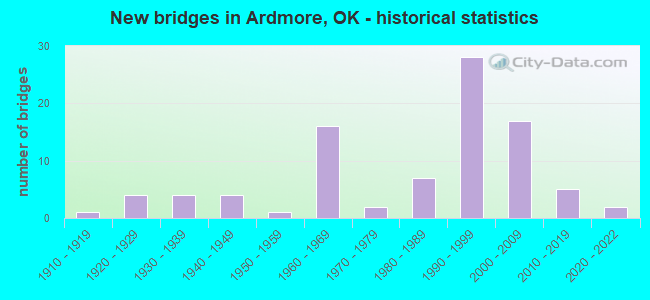
- New bridges - historical statistics
- 11910-1919
- 41920-1929
- 41930-1939
- 41940-1949
- 11950-1959
- 161960-1969
- 21970-1979
- 71980-1989
- 281990-1999
- 172000-2009
- 52010-2019
- 22020-2022
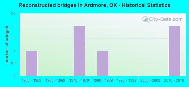
- Reconstructed bridges - Historical Statistics
- 11950-1959
- 01960-1969
- 21970-1979
- 11980-1989
- 01990-1999
- 02000-2009
- 22010-2019
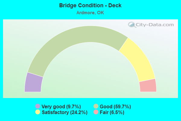
- Bridge Condition - Deck
- 9.7%Very good
- 59.7%Good
- 24.2%Satisfactory
- 6.5%Fair
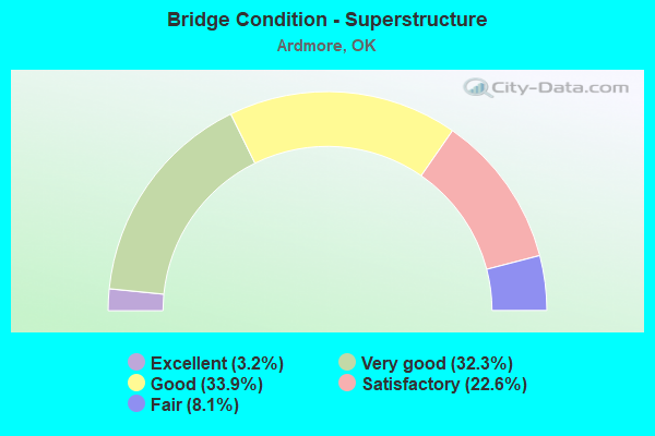
- Bridge Condition - Superstructure
- 3.2%Excellent
- 32.3%Very good
- 33.9%Good
- 22.6%Satisfactory
- 8.1%Fair
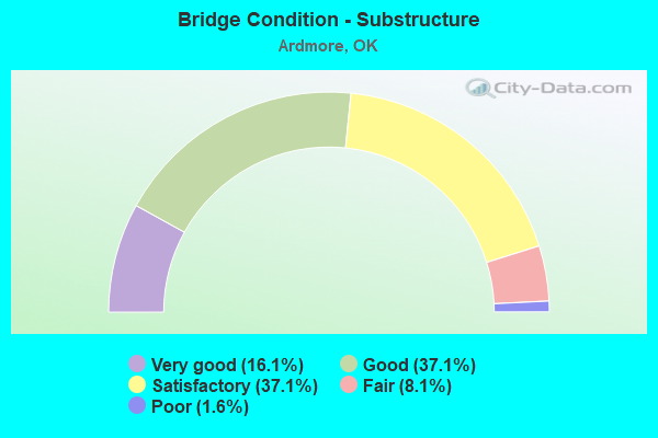
- Bridge Condition - Substructure
- 16.1%Very good
- 37.1%Good
- 37.1%Satisfactory
- 8.1%Fair
- 1.6%Poor
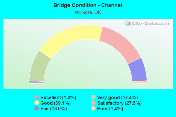
- Bridge Condition - Channel
- 1.4%Excellent
- 17.4%Very good
- 39.1%Good
- 27.5%Satisfactory
- 13.0%Fair
- 1.4%Poor
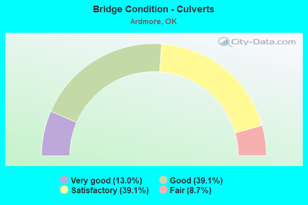
- Bridge Condition - Culverts
- 13.0%Very good
- 39.1%Good
- 39.1%Satisfactory
- 8.7%Fair
Find on map >> Show street view
Structure Number: 30366, Location: 12.8 N WOODWARD C/L (Lat: 36.770053, Lng: -99.366964), Route carried "on" structure: State highway 34, Year Built: 2016, Status: Open, Structure Length: 11.89m (39.01ft), Average Daily Traffic: 370 (year 2020), Truck Traffic: 16%, Average Future Daily Traffic: 592 (year 2040), Design Load: HL 93, Features Intersected: BUFFALO CREEK
Minimum Vertical Clearance: 30+ m (98+ ft), Kilometerpoint: 20.096, Lanes on structure: 2, Base Highway Network: Yes, Owner: State Highway Agency, Approaching Roadway Width: 12.2m (40.0ft), Skew: 3 degrees, Material/Design: Prestressed concrete, Design/Construction: Stringer/Multi-beam, Number Of Spans In Main Unit: 3, Length of Maximum Span: 39.6m (129.9ft), Curb-To-Curb Width: 12.2m (40.0ft), Out-to-Out Width: 12.9m (42.3ft)
Condition: Deck: Very good, Superstructure: Excellent, Substructure: Very good, Channel: Good, Operating Rating: 68.9 metric tons, Method Used To Determine Operating Rating: Load and Resistance Factor (LRFR), Inventory Rating: 28.1 metric tons, Method Used To Determine Inventory Rating: Load and Resistance Factor (LRFR), Structural Evaluation: Better than present minimum criteria, Deck Geometry: Superior to present desirable criteria, Waterway Adequacy: Equal to present desirable criteria, Approach Roadway Alignment: Equal to present desirable criteria, Designated Inspection Frequency: Every 24 months, Inspection Date: August 2020, Deck Structure Type: Concrete Cast-file-Place, Wearing Surface/Protective System: Wearing Surface: Monolithic Concrete, Deck Protection: Epoxy Coated Reinforcing
Find on map >> Show street view
Structure Number: 30866, Location: 1.3S .5W OF I-35/US70 JCT (Lat: 34.125556, Lng: -97.168889), Route carried "on" structure: County highway E1993, Year Built: 2013, Status: Open, Structure Length: 1.71m (5.61ft), Average Daily Traffic: 200 (year 2020), Truck Traffic: 10%, Average Future Daily Traffic: 320 (year 2040), Design Load: HS 20, Features Intersected: CREEK
Minimum Vertical Clearance: 30+ m (98+ ft), Kilometerpoint: 0.805, Lanes on structure: 2, Owner: County Highway Agency, Approaching Roadway Width: 7.9m (25.9ft), Material/Design: Steel, Design/Construction: Stringer/Multi-beam, Number Of Spans In Main Unit: 1, Length of Maximum Span: 17.1m (56.1ft), Curb-To-Curb Width: 8.4m (27.6ft), Out-to-Out Width: 8.5m (27.9ft)
Condition: Deck: Good, Superstructure: Satisfactory, Substructure: Satisfactory, Channel: Fair, Operating Rating: 47.2 metric tons, Method Used To Determine Operating Rating: Load Factor (LF), Inventory Rating: 28.1 metric tons, Method Used To Determine Inventory Rating: Load Factor (LF), Structural Evaluation: Equal to present minimum criteria, Deck Geometry: Somewhat better than minimum adequacy, Waterway Adequacy: Equal to present desirable criteria, Approach Roadway Alignment: Equal to present minimum criteria, Designated Inspection Frequency: Every 24 months, Inspection Date: March 2021, Deck Structure Type: Concrete Cast-file-Place, Wearing Surface/Protective System: Wearing Surface: Monolithic Concrete
Find on map >> Show street view
Structure Number: 30874, Location: 12 E OF S.H. 76 (Lat: 34.332786, Lng: -97.296839), Route carried "on" structure: State highway 53, Year Built: 2020, Status: Open, Structure Length: 6.25m (20.51ft), Average Daily Traffic: 1,400 (year 2020), Average Future Daily Traffic: 2,240 (year 2040), Design Load: HL 93, Features Intersected: HICKORY CREEK
Minimum Vertical Clearance: 30.45m (99.90ft), Kilometerpoint: 31.099, Lanes on structure: 2, Owner: State Highway Agency, Approaching Roadway Width: 12.2m (40.0ft), Material/Design: Prestressed concrete, Design/Construction: Stringer/Multi-beam, Number Of Spans In Main Unit: 3, Length of Maximum Span: 22.9m (75.1ft), Curb-To-Curb Width: 12.2m (40.0ft), Out-to-Out Width: 12.9m (42.3ft)
Condition: Deck: Very good, Superstructure: Excellent, Substructure: Very good, Channel: Very good, Operating Rating: 44.5 metric tons, Method Used To Determine Operating Rating: Load and Resistance Factor (LRFR), Inventory Rating: 26.3 metric tons, Method Used To Determine Inventory Rating: Load and Resistance Factor (LRFR), Structural Evaluation: Equal to present minimum criteria, Deck Geometry: Better than present minimum criteria, Waterway Adequacy: Equal to present desirable criteria, Approach Roadway Alignment: Equal to present desirable criteria, Designated Inspection Frequency: Every 24 months, Inspection Date: October 2020, Deck Structure Type: Concrete Cast-file-Place, Wearing Surface/Protective System: Wearing Surface: Monolithic Concrete
Find on map >> Show street view
Structure Number: 30907, Location: 13.8 E S.H. 76 (Lat: 34.332689, Lng: -97.264553), Route carried "on" structure: State highway 53, Year Built: 2020, Status: Open, Structure Length: 0.61m (2.00ft), Average Daily Traffic: 1,400 (year 2020), Truck Traffic: 15%, Average Future Daily Traffic: 2,240 (year 2040), Design Load: HL 93, Features Intersected: CREEK
Minimum Vertical Clearance: 30+ m (98+ ft), Kilometerpoint: 35.838, Lanes on structure: 2, Owner: State Highway Agency, Approaching Roadway Width: 12.2m (40.0ft), Material/Design: Concrete, Design/Construction: Culvert, Number Of Spans In Main Unit: 2, Length of Maximum Span: 3.0m (9.8ft), Curb-To-Curb Width: 25.6m (84.0ft), Out-to-Out Width: 26.2m (86.0ft)
Condition: Channel: Good, Culverts: Very good, Operating Rating: 90.7 metric tons, Method Used To Determine Operating Rating: Load and Resistance Factor (LRFR), Inventory Rating: 90.7 metric tons, Method Used To Determine Inventory Rating: Load and Resistance Factor (LRFR), Structural Evaluation: Equal to present desirable criteria, Deck Geometry: Superior to present desirable criteria, Waterway Adequacy: Equal to present desirable criteria, Approach Roadway Alignment: Equal to present desirable criteria, Designated Inspection Frequency: Every 24 months, Inspection Date: October 2020
Find on map >> Show street view
Structure Number: 31453, Location: 1.3S .8W OF I-35/US70 (Lat: 34.123611, Lng: -97.173333), Route carried "on" structure: County highway E1993, Year Built: 2015, Status: Open, Structure Length: 1.52m (4.99ft), Average Daily Traffic: 200 (year 2020), Truck Traffic: 10%, Average Future Daily Traffic: 320 (year 2040), Design Load: HS 20, Features Intersected: CREEK
Minimum Vertical Clearance: 30+ m (98+ ft), Kilometerpoint: 0.322, Lanes on structure: 2, Owner: County Highway Agency, Approaching Roadway Width: 7.9m (25.9ft), Material/Design: Steel, Design/Construction: Stringer/Multi-beam, Number Of Spans In Main Unit: 1, Length of Maximum Span: 15.2m (49.9ft), Curb-To-Curb Width: 8.2m (26.9ft), Out-to-Out Width: 8.4m (27.6ft)
Condition: Deck: Good, Superstructure: Fair, Substructure: Satisfactory, Channel: Fair, Operating Rating: 68.1 metric tons, Method Used To Determine Operating Rating: Load Factor (LF), Inventory Rating: 40.9 metric tons, Method Used To Determine Inventory Rating: Load Factor (LF), Structural Evaluation: Somewhat better than minimum adequacy, Deck Geometry: Somewhat better than minimum adequacy, Waterway Adequacy: Equal to present desirable criteria, Approach Roadway Alignment: Better than present minimum criteria, Designated Inspection Frequency: Every 24 months, Inspection Date: March 2021, Deck Structure Type: Concrete Cast-file-Place, Wearing Surface/Protective System: Wearing Surface: Monolithic Concrete
Find on map >> Show street view
Structure Number: 31983, Location: 4.8E OF U.S. 70 (Lat: 34.143333, Lng: -97.058889), Route carried "on" structure: County highway E1980, Year Built: 2016, Status: Open, Structure Length: 2.29m (7.51ft), Average Daily Traffic: 391 (year 2020), Truck Traffic: 10%, Average Future Daily Traffic: 625 (year 2040), Design Load: HS 20, Features Intersected: CREEK
Minimum Vertical Clearance: 30+ m (98+ ft), Kilometerpoint: 1.287, Lanes on structure: 2, Owner: County Highway Agency, Approaching Roadway Width: 7.9m (25.9ft), Material/Design: Steel, Design/Construction: Stringer/Multi-beam, Number Of Spans In Main Unit: 1, Length of Maximum Span: 22.9m (75.1ft), Curb-To-Curb Width: 7.9m (25.9ft), Out-to-Out Width: 7.9m (25.9ft)
Condition: Deck: Good, Superstructure: Good, Substructure: Satisfactory, Channel: Good, Operating Rating: 59.9 metric tons, Method Used To Determine Operating Rating: Load Factor (LF), Inventory Rating: 35.4 metric tons, Method Used To Determine Inventory Rating: Load Factor (LF), Structural Evaluation: Equal to present minimum criteria, Deck Geometry: Somewhat better than minimum adequacy, Waterway Adequacy: Equal to present desirable criteria, Approach Roadway Alignment: Equal to present desirable criteria, Designated Inspection Frequency: Every 24 months, Inspection Date: April 2021, Deck Structure Type: Concrete Cast-file-Place, Wearing Surface/Protective System: Wearing Surface: Monolithic Concrete
Find on map >> Show street view
Structure Number: 1657, Location: 2.1 MI N JCT US70 (Lat: 34.201822, Lng: -97.164319), Route carried "under" structure: State highway 142, Year Built: 1965, Structure Length: 0. m, Average Daily Traffic: 9,500 (year 2020), Truck Traffic: 7%, Features Intersected: S.H. 142 UNDER, Facility Carried by Structure: I-35 SB
Minimum Vertical Clearance: 5.11m (16.77ft), Kilometerpoint: 0.000, Lanes on structure: 2, Lanes under structure: 4, Material/Design: Concrete continuous, Design/Construction: Slab, Length of Maximum Span: 17.4m (57.1ft)
Find on map >> Show street view
Structure Number: 16571, Location: 2.1 MI N JCT US70 (Lat: 34.201819, Lng: -97.163742), Route carried "under" structure: State highway 142, Year Built: 1965, Structure Length: 0. m, Average Daily Traffic: 9,500 (year 2020), Truck Traffic: 7%, Features Intersected: S.H. 142 UNDER, Facility Carried by Structure: I-35 NB
Minimum Vertical Clearance: 5.11m (16.77ft), Kilometerpoint: 0.032, Lanes on structure: 2, Lanes under structure: 4, Material/Design: Concrete continuous, Design/Construction: Slab, Length of Maximum Span: 17.4m (57.1ft)
Find on map >> Show street view
Structure Number: 1658, Location: 4.7 MI N LOVE C/L (Lat: 34.139042, Lng: -97.155442), Route carried "under" structure: US 70, Year Built: 1965, Structure Length: 0. m, Average Daily Traffic: 4,800 (year 2020), Truck Traffic: 7%, Features Intersected: U.S. 70 UNDER, Facility Carried by Structure: I-35 NB
Minimum Vertical Clearance: 4.98m (16.34ft), Kilometerpoint: 0.032, Lanes on structure: 2, Lanes under structure: 4, Material/Design: Steel, Design/Construction: Stringer/Multi-beam, Length of Maximum Span: 17.4m (57.1ft)
Find on map >> Show street view
Structure Number: 16589, Location: 7.2 MI N LOVE C/L (Lat: 34.172611, Lng: -97.168333), Route carried "under" structure: US 70, Year Built: 1965, Structure Length: 0. m, Average Daily Traffic: 17,800 (year 2020), Truck Traffic: 7%, Features Intersected: U.S. 70 UNDER, Facility Carried by Structure: I-35 SB
Minimum Vertical Clearance: 5.41m (17.75ft), Kilometerpoint: 36.331, Lanes on structure: 3, Lanes under structure: 4, Material/Design: Steel, Design/Construction: Stringer/Multi-beam, Length of Maximum Span: 19.3m (63.3ft)
Find on map >> Show street view
Structure Number: 16612, Location: 3.0 MI N LOVE C/L (Lat: 34.114669, Lng: -97.154119), Route carried "under" structure: Interstate 35, Year Built: 1965, Structure Length: 0. m, Average Daily Traffic: 32,400 (year 2020), Truck Traffic: 36%, Features Intersected: I-35 UNDER, Facility Carried by Structure: CO. RD. E2000
Minimum Vertical Clearance: 5.03m (16.50ft), Kilometerpoint: 4.843, Lanes on structure: 2, Lanes under structure: 4, Material/Design: Steel continuous, Design/Construction: Stringer/Multi-beam, Length of Maximum Span: 18.3m (60.0ft)
Find on map >> Show street view
Structure Number: 224, Location: 1.0 MI N JCT US70 (Lat: 34.187567, Lng: -97.166772), Route carried "under" structure: Interstate 35, Year Built: 1989, Structure Length: 0. m, Average Daily Traffic: 32,600 (year 2020), Truck Traffic: 12%, Features Intersected: I-35 UNDER, Facility Carried by Structure: FAU 4920 (12 ST.)
Minimum Vertical Clearance: 5.11m (16.77ft), Kilometerpoint: 13.209, Lanes on structure: 4, Lanes under structure: 6, Material/Design: Steel continuous, Design/Construction: Stringer/Multi-beam, Length of Maximum Span: 46.9m (153.9ft)