Bridge Statistics for Apex, North Carolina (NC)
Condition, Traffic, Stress, Structural Evaluation, Project Costs
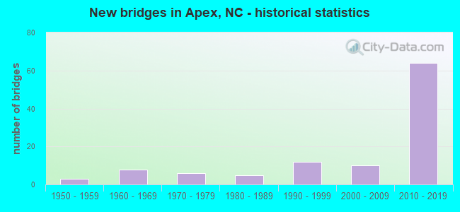
- New bridges - historical statistics
- 31950-1959
- 81960-1969
- 61970-1979
- 51980-1989
- 121990-1999
- 102000-2009
- 642010-2019
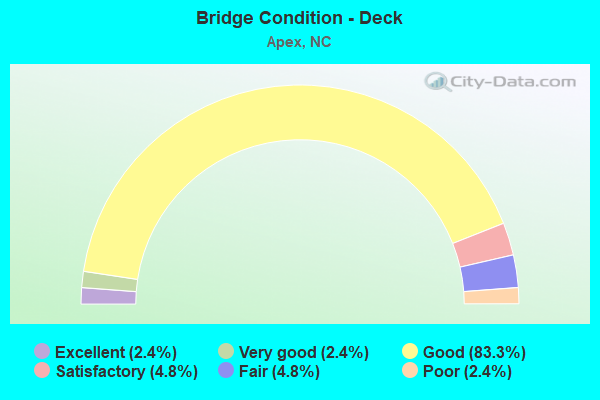
- Bridge Condition - Deck
- 2.4%Excellent
- 2.4%Very good
- 83.3%Good
- 4.8%Satisfactory
- 4.8%Fair
- 2.4%Poor
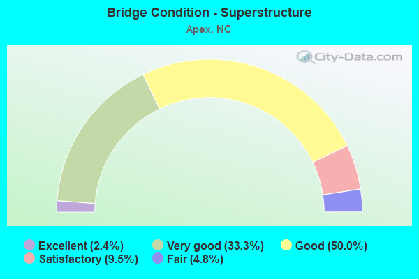
- Bridge Condition - Superstructure
- 2.4%Excellent
- 33.3%Very good
- 50.0%Good
- 9.5%Satisfactory
- 4.8%Fair
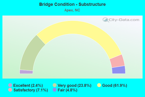
- Bridge Condition - Substructure
- 2.4%Excellent
- 23.8%Very good
- 61.9%Good
- 7.1%Satisfactory
- 4.8%Fair
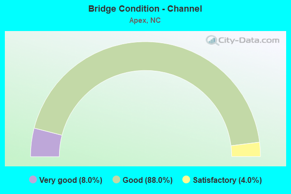
- Bridge Condition - Channel
- 8.0%Very good
- 88.0%Good
- 4.0%Satisfactory
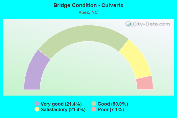
- Bridge Condition - Culverts
- 21.4%Very good
- 50.0%Good
- 21.4%Satisfactory
- 7.1%Poor
Find on map >> Show street view
Structure Number: 1831293, Location: .1MI.W.JCT.NC540&US64 (Lat: 35.746828, Lng: -78.894550), Route carried "on" structure: State highway 1163, Year Built: 2012, Status: Open, Structure Length: 6.61m (21.69ft), Average Daily Traffic: 8,800 (year 2019), Truck Traffic: 6%, Average Future Daily Traffic: 17,600 (year 2025), Design Load: HL 93, Features Intersected: US64
Minimum Vertical Clearance: 30+ m (98+ ft), Kilometerpoint: 0.000, Lanes on structure: 4, Lanes under structure: 6, Owner: State Highway Agency, Approaching Roadway Width: 19.8m (65.0ft), Material/Design: Prestressed concrete, Design/Construction: Stringer/Multi-beam, Number Of Spans In Main Unit: 2, Length of Maximum Span: 32.0m (105.0ft), Curb-To-Curb Width: 18.8m (61.7ft), Out-to-Out Width: 19.9m (65.3ft)
Condition: Deck: Good, Superstructure: Very good, Substructure: Very good, Operating Rating: 89.8 metric tons, Method Used To Determine Operating Rating: Load and Resistance Factor (LRFR), Inventory Rating: 70.7 metric tons, Method Used To Determine Inventory Rating: Load and Resistance Factor (LRFR), Structural Evaluation: Equal to present desirable criteria, Deck Geometry: Equal to present minimum criteria, Underclear: Superior to present desirable criteria, Approach Roadway Alignment: Equal to present desirable criteria, Designated Inspection Frequency: Every 24 months, Inspection Date: July 2021, Deck Structure Type: Concrete Cast-file-Place, Wearing Surface/Protective System: Wearing Surface: Monolithic Concrete, Deck Protection: Epoxy Coated Reinforcing
Find on map >> Show street view
Structure Number: 1831294, Location: 0.25 MI. E. JCT. SR1600 (Lat: 35.755078, Lng: -78.891589), Route carried "on" structure: State highway 1601, Year Built: 2012, Status: Open, Structure Length: 6.37m (20.90ft), Average Daily Traffic: 3,700 (year 2015), Truck Traffic: 7%, Average Future Daily Traffic: 7,400 (year 2040), Design Load: HL 93, Features Intersected: NC540 TOLL
Minimum Vertical Clearance: 6.52m (21.39ft), Kilometerpoint: 0.000, Lanes on structure: 3, Lanes under structure: 7, Owner: State Highway Agency, Approaching Roadway Width: 15.5m (50.9ft), Skew: 1 degrees, Material/Design: Prestressed concrete continuous, Design/Construction: Stringer/Multi-beam, Number Of Spans In Main Unit: 2, Length of Maximum Span: 31.0m (101.7ft), Curb or Sidewalk Widths: Left: 1.6m (5.2ft), Right: 1.6m (5.2ft), Curb-To-Curb Width: 12.1m (39.7ft), Out-to-Out Width: 16.4m (53.8ft)
Condition: Deck: Good, Superstructure: Good, Substructure: Good, Operating Rating: 68.0 metric tons, Method Used To Determine Operating Rating: Load and Resistance Factor (LRFR), Inventory Rating: 51.7 metric tons, Method Used To Determine Inventory Rating: Load and Resistance Factor (LRFR), Structural Evaluation: Better than present minimum criteria, Deck Geometry: Meets minimum limits, Underclear: High priority of corrective action, Approach Roadway Alignment: Equal to present desirable criteria, Designated Inspection Frequency: Every 24 months, Inspection Date: October 2020, Deck Structure Type: Concrete Cast-file-Place, Wearing Surface/Protective System: Wearing Surface: Monolithic Concrete, Deck Protection: Epoxy Coated Reinforcing
Find on map >> Show street view
Structure Number: 1831295, Location: 0.55 MI. E. JCT SR1600 (Lat: 35.766906, Lng: -78.886808), Route carried "on" structure: State highway 1608, Year Built: 2012, Status: Open, Structure Length: 6.67m (21.88ft), Average Daily Traffic: 2,300 (year 2009), Truck Traffic: 7%, Average Future Daily Traffic: 4,600 (year 2040), Design Load: HL 93, Features Intersected: NC540
Minimum Vertical Clearance: 30+ m (98+ ft), Kilometerpoint: 0.000, Lanes on structure: 2, Lanes under structure: 6, Owner: State Highway Agency, Approaching Roadway Width: 10.3m (33.8ft), Skew: 2 degrees, Material/Design: Prestressed concrete, Design/Construction: Stringer/Multi-beam, Number Of Spans In Main Unit: 2, Length of Maximum Span: 32.3m (106.0ft), Curb-To-Curb Width: 10.5m (34.4ft), Out-to-Out Width: 11.5m (37.7ft)
Condition: Deck: Good, Superstructure: Good, Substructure: Good, Operating Rating: 89.8 metric tons, Method Used To Determine Operating Rating: Load and Resistance Factor (LRFR), Inventory Rating: 50.8 metric tons, Method Used To Determine Inventory Rating: Load and Resistance Factor (LRFR), Structural Evaluation: Better than present minimum criteria, Deck Geometry: Somewhat better than minimum adequacy, Underclear: Equal to present minimum criteria, Approach Roadway Alignment: Equal to present desirable criteria, Designated Inspection Frequency: Every 24 months, Inspection Date: October 2020, Deck Structure Type: Concrete Cast-file-Place, Wearing Surface/Protective System: Wearing Surface: Monolithic Concrete, Deck Protection: Epoxy Coated Reinforcing
Find on map >> Show street view
Structure Number: 1831318, Location: 0.4MI.WESTJCT.NC55 (Lat: 35.747156, Lng: -78.878958), Route carried "on" structure: City street , Year Built: 2008, Status: Open, Structure Length: 1.03m (3.38ft), Average Daily Traffic: 1,301 (year 2009), Truck Traffic: 7%, Average Future Daily Traffic: 2,602 (year 2025), Design Load: HS 20, Features Intersected: BEAVER CREEK, Facility Carried by Structure: BEAVER COMMONS RD.
Minimum Vertical Clearance: 30+ m (98+ ft), Kilometerpoint: 0.000, Lanes on structure: 2, Owner: City or Municipal Highway Agency, Approaching Roadway Width: 8.2m (26.9ft), Material/Design: Concrete continuous, Design/Construction: Culvert, Number Of Spans In Main Unit: 3, Length of Maximum Span: 3.3m (10.8ft), Curb or Sidewalk Widths: Left: 0.0m, Right: 2.4m (7.9ft)
Condition: Channel: Good, Culverts: Good, Operating Rating: 41.7 metric tons, Method Used To Determine Operating Rating: Field evaluation and documented engineering judgment, Inventory Rating: 32.6 metric tons, Method Used To Determine Inventory Rating: Field evaluation and documented engineering judgment, Structural Evaluation: Better than present minimum criteria, Waterway Adequacy: Better than present minimum criteria, Approach Roadway Alignment: Equal to present desirable criteria, Designated Inspection Frequency: Every 24 months, Inspection Date: March 2020
Find on map >> Show street view
Structure Number: 1831319, Location: 0. MI.S.JCT. SR1162 (Lat: 35.718733, Lng: -78.903297), Route carried "on" structure: City street , Year Built: 2008, Status: Open, Structure Length: 0.76m (2.49ft), Average Daily Traffic: 1,500 (year 2018), Truck Traffic: 7%, Average Future Daily Traffic: 3,000 (year 2040), Design Load: HS 20, Features Intersected: BR. OF BEAVER CREEK, Facility Carried by Structure: EVANS ROAD
Minimum Vertical Clearance: 0.00m, Kilometerpoint: 0.000, Lanes on structure: 2, Owner: City or Municipal Highway Agency, Approaching Roadway Width: 8.5m (27.9ft), Skew: 3 degrees, Material/Design: Concrete continuous, Design/Construction: Culvert, Number Of Spans In Main Unit: 2, Length of Maximum Span: 3.0m (9.8ft), Curb or Sidewalk Widths: Left: 3.0m (9.8ft), Right: 0.0m
Condition: Channel: Good, Culverts: Good, Operating Rating: 41.7 metric tons, Method Used To Determine Operating Rating: Field evaluation and documented engineering judgment, Inventory Rating: 32.6 metric tons, Method Used To Determine Inventory Rating: Field evaluation and documented engineering judgment, Structural Evaluation: Better than present minimum criteria, Waterway Adequacy: Better than present minimum criteria, Approach Roadway Alignment: Equal to present desirable criteria, Designated Inspection Frequency: Every 24 months, Inspection Date: March 2020
Find on map >> Show street view
Structure Number: 1831344, Location: 0.2 MI. W. JCT. SR1306 (Lat: 35.740653, Lng: -78.844519), Route carried "on" structure: City street , Year Built: 2010, Status: Open, Structure Length: 6.21m (20.37ft), Average Daily Traffic: 11,000 (year 2017), Truck Traffic: 7%, Average Future Daily Traffic: 22,000 (year 2040), Design Load: HS 20, Features Intersected: CSX RAILROAD, Facility Carried by Structure: APEX PEAKWAY
Minimum Vertical Clearance: 30+ m (98+ ft), Kilometerpoint: 0.000, Lanes on structure: 2, Owner: City or Municipal Highway Agency, Approaching Roadway Width: 8.5m (27.9ft), Material/Design: Prestressed concrete continuous, Design/Construction: Stringer/Multi-beam, Number Of Spans In Main Unit: 3, Length of Maximum Span: 28.0m (91.9ft), Curb or Sidewalk Widths: Left: 1.7m (5.6ft), Right: 0.0m, Curb-To-Curb Width: 8.4m (27.6ft), Out-to-Out Width: 11.0m (36.1ft)
Condition: Deck: Good, Superstructure: Good, Substructure: Good, Operating Rating: 49.8 metric tons, Method Used To Determine Operating Rating: Field evaluation and documented engineering judgment, Inventory Rating: 30.8 metric tons, Method Used To Determine Inventory Rating: Field evaluation and documented engineering judgment, Structural Evaluation: Better than present minimum criteria, Deck Geometry: High priority of corrective action, Underclear: Superior to present desirable criteria, Approach Roadway Alignment: Equal to present desirable criteria, Designated Inspection Frequency: Every 24 months, Inspection Date: March 2020, Deck Structure Type: Concrete Cast-file-Place, Wearing Surface/Protective System: Wearing Surface: Monolithic Concrete, Deck Protection: Epoxy Coated Reinforcing
Find on map >> Show street view
Structure Number: 1831472, Location: 0.16 MI.E.JCT.STEWART ST. (Lat: 35.602800, Lng: -78.786092), Route carried "on" structure: City street , Year Built: 2015, Status: Open, Structure Length: 0.73m (2.40ft), Average Daily Traffic: 21,000 (year 2016), Truck Traffic: 7%, Average Future Daily Traffic: 42,000 (year 2040), Design Load: HS 20+Mod, Features Intersected: TERRIBLE CREEK, Facility Carried by Structure: JUDD PARKWAY
Minimum Vertical Clearance: 30+ m (98+ ft), Kilometerpoint: 0.000, Lanes on structure: 2, Owner: City or Municipal Highway Agency, Approaching Roadway Width: 8.5m (27.9ft), Skew: 3 degrees, Material/Design: Concrete continuous, Design/Construction: Culvert, Number Of Spans In Main Unit: 2, Length of Maximum Span: 3.0m (9.8ft)
Condition: Channel: Good, Culverts: Good, Operating Rating: 78.0 metric tons, Method Used To Determine Operating Rating: Load and Resistance Factor (LRFR), Inventory Rating: 45.3 metric tons, Method Used To Determine Inventory Rating: Load and Resistance Factor (LRFR), Structural Evaluation: Better than present minimum criteria, Waterway Adequacy: Better than present minimum criteria, Approach Roadway Alignment: Equal to present desirable criteria, Designated Inspection Frequency: Every 24 months, Inspection Date: March 2022
Find on map >> Show street view
Structure Number: 1831477, Location: 200' N. SALEM VILLAGE DR (Lat: 35.711608, Lng: -78.869519), Route carried "on" structure: City street , Year Built: 2013, Status: Open, Structure Length: 0.97m (3.18ft), Average Daily Traffic: 100 (year 2018), Truck Traffic: 9%, Average Future Daily Traffic: 200 (year 2040), Design Load: HS 20+Mod, Features Intersected: BIG BRANCH, Facility Carried by Structure: FLINT VALLEY LN.
Minimum Vertical Clearance: 30+ m (98+ ft), Kilometerpoint: 0.000, Lanes on structure: 2, Owner: City or Municipal Highway Agency, Approaching Roadway Width: 7.9m (25.9ft), Material/Design: Concrete continuous, Design/Construction: Culvert, Number Of Spans In Main Unit: 1, Length of Maximum Span: 9.7m (31.8ft)
Condition: Channel: Good, Culverts: Very good, Operating Rating: 41.7 metric tons, Method Used To Determine Operating Rating: Field evaluation and documented engineering judgment, Inventory Rating: 32.6 metric tons, Method Used To Determine Inventory Rating: Field evaluation and documented engineering judgment, Structural Evaluation: Equal to present desirable criteria, Waterway Adequacy: Better than present minimum criteria, Approach Roadway Alignment: Equal to present desirable criteria, Designated Inspection Frequency: Every 24 months, Inspection Date: March 2020
Find on map >> Show street view
Structure Number: 1831479, Location: 0.2 MI W. JCT. SR1153 (Lat: 35.715044, Lng: -78.863064), Route carried "on" structure: City street , Year Built: 2012, Status: Open, Structure Length: 0.97m (3.18ft), Average Daily Traffic: 3,600 (year 2017), Truck Traffic: 7%, Average Future Daily Traffic: 7,200 (year 2040), Design Load: HS 20, Features Intersected: BIG BRANCH, Facility Carried by Structure: APEX PEAKWAY
Minimum Vertical Clearance: 30+ m (98+ ft), Kilometerpoint: 0.000, Lanes on structure: 2, Owner: City or Municipal Highway Agency, Approaching Roadway Width: 9.7m (31.8ft), Material/Design: Concrete continuous, Design/Construction: Culvert, Number Of Spans In Main Unit: 1, Length of Maximum Span: 9.7m (31.8ft)
Condition: Channel: Good, Culverts: Very good, Operating Rating: 41.7 metric tons, Method Used To Determine Operating Rating: Field evaluation and documented engineering judgment, Inventory Rating: 32.6 metric tons, Method Used To Determine Inventory Rating: Field evaluation and documented engineering judgment, Structural Evaluation: Equal to present desirable criteria, Waterway Adequacy: Better than present minimum criteria, Approach Roadway Alignment: Equal to present desirable criteria, Designated Inspection Frequency: Every 24 months, Inspection Date: March 2020
Find on map >> Show street view
Structure Number: 1831496, Location: INT. CABARRUS/MCDOWELL ST (Lat: 35.774289, Lng: -78.642061), Route carried "on" structure: City street , Year Built: 2006, Status: Open, Structure Length: 2.71m (8.89ft), Average Daily Traffic: 18,000 (year 2017), Truck Traffic: 12%, Average Future Daily Traffic: 36,000 (year 2040), Design Load: HS 20+Mod, Features Intersected: CONVENTION CENTER, Facility Carried by Structure: S.MCDOWELL ST.
Minimum Vertical Clearance: 30+ m (98+ ft), Kilometerpoint: 0.000, Lanes on structure: 3, Owner: City or Municipal Highway Agency, Approaching Roadway Width: 11.5m (37.7ft), Material/Design: Prestressed concrete, Design/Construction: Stringer/Multi-beam, Number Of Spans In Main Unit: 6, Length of Maximum Span: 25.9m (85.0ft), Curb-To-Curb Width: 10.9m (35.8ft), Out-to-Out Width: 28.8m (94.5ft)
Condition: Deck: Good, Superstructure: Good, Substructure: Good, Operating Rating: 49.8 metric tons, Method Used To Determine Operating Rating: Field evaluation and documented engineering judgment, Inventory Rating: 30.8 metric tons, Method Used To Determine Inventory Rating: Field evaluation and documented engineering judgment, Structural Evaluation: Better than present minimum criteria, Deck Geometry: High priority of replacement, Approach Roadway Alignment: Equal to present desirable criteria, Designated Inspection Frequency: Every 24 months, Inspection Date: Febuary 2020, Deck Structure Type: Concrete Cast-file-Place, Wearing Surface/Protective System: Wearing Surface: Bituminous
Find on map >> Show street view
Structure Number: 1831498, Location: 0.25 MI. NORTH OF SR1160 (Lat: 35.742200, Lng: -78.892100), Route carried "on" structure: ServiceState highway 540, Year Built: 2013, Status: Open, Structure Length: 0.88m (2.89ft), Average Daily Traffic: 20,001 (year 2015), Truck Traffic: 12%, Average Future Daily Traffic: 40,000 (year 2040), Design Load: HS 20+Mod, Features Intersected: REEDY CREEK
Minimum Vertical Clearance: 30+ m (98+ ft), Kilometerpoint: 17.986, Lanes on structure: 8, Base Highway Network: Yes (Inventory Route: 3, Subroute: 40), Toll: On Interstate toll segment, Owner: State Highway Agency, Approaching Roadway Width: 41.4m (135.8ft), Skew: 3 degrees, Material/Design: Concrete continuous, Design/Construction: Culvert, Number Of Spans In Main Unit: 2, Length of Maximum Span: 3.6m (11.8ft)
Condition: Channel: Good, Culverts: Good, Operating Rating: 57.1 metric tons, Method Used To Determine Operating Rating: Load and Resistance Factor (LRFR), Inventory Rating: 43.5 metric tons, Method Used To Determine Inventory Rating: Load and Resistance Factor (LRFR), Structural Evaluation: Better than present minimum criteria, Waterway Adequacy: Better than present minimum criteria, Approach Roadway Alignment: Equal to present desirable criteria, Designated Inspection Frequency: Every 24 months, Inspection Date: April 2020
Find on map >> Show street view
Structure Number: 1831565, Location: 0.12 MI. W. JCT. SR1647 (Lat: 35.901644, Lng: -78.739197), Route carried "on" structure: State highway 1837, Year Built: 2019, Status: Open, Structure Length: 1.21m (3.97ft), Average Daily Traffic: 13,000 (year 2017), Truck Traffic: 7%, Average Future Daily Traffic: 26,000 (year 2040), Design Load: HL 93, Features Intersected: QUARRY DIRT ROAD
Minimum Vertical Clearance: 30+ m (98+ ft), Kilometerpoint: 0.000, Lanes on structure: 2, Owner: State Highway Agency, Approaching Roadway Width: 12.4m (40.7ft), Material/Design: Prestressed concrete, Design/Construction: Slab, Number Of Spans In Main Unit: 1, Length of Maximum Span: 11.2m (36.7ft), Curb or Sidewalk Widths: Left: 2.4m (7.9ft), Right: 0.0m, Curb-To-Curb Width: 12.2m (40.0ft), Out-to-Out Width: 15.5m (50.9ft)
Condition: Deck: Good, Superstructure: Good, Substructure: Very good, Operating Rating: 74.3 metric tons, Method Used To Determine Operating Rating: Load and Resistance Factor (LRFR), Inventory Rating: 57.1 metric tons, Method Used To Determine Inventory Rating: Load and Resistance Factor (LRFR), Structural Evaluation: Better than present minimum criteria, Deck Geometry: Somewhat better than minimum adequacy, Approach Roadway Alignment: Equal to present desirable criteria, Designated Inspection Frequency: Every 24 months, Inspection Date: September 2021, Deck Structure Type: Concrete Precast Panels, Wearing Surface/Protective System: Wearing Surface: Bituminous, Deck Protection: Epoxy Coated Reinforcing
Find on map >> Show street view
Structure Number: 1831567, Location: 250' W. JCT. QUEEN CITY (Lat: 35.748600, Lng: -78.886800), Route carried "on" structure: City street , Year Built: 2006, Status: Open, Structure Length: 4.63m (15.19ft), Average Daily Traffic: 100 (year 2018), Truck Traffic: 7%, Average Future Daily Traffic: 200 (year 2040), Design Load: HS 20, Features Intersected: CREEK, Facility Carried by Structure: REEDYBROOK CRSG
Minimum Vertical Clearance: 30+ m (98+ ft), Kilometerpoint: 0.000, Lanes on structure: 2, Owner: City or Municipal Highway Agency, Approaching Roadway Width: 8.2m (26.9ft), Material/Design: Prestressed concrete, Design/Construction: Slab, Number Of Spans In Main Unit: 3, Length of Maximum Span: 15.5m (50.9ft), Curb or Sidewalk Widths: Left: 1.8m (5.9ft), Right: 0.0m, Curb-To-Curb Width: 8.2m (26.9ft), Out-to-Out Width: 10.9m (35.8ft)
Condition: Deck: Excellent, Superstructure: Excellent, Substructure: Excellent, Channel: Good, Operating Rating: 89.8 metric tons, Method Used To Determine Operating Rating: Load Factor (LF), Inventory Rating: 55.3 metric tons, Method Used To Determine Inventory Rating: Load Factor (LF), Structural Evaluation: Superior to present desirable criteria, Deck Geometry: Equal to present minimum criteria, Waterway Adequacy: Better than present minimum criteria, Approach Roadway Alignment: Equal to present desirable criteria, Designated Inspection Frequency: Every 24 months, Inspection Date: March 2022, Deck Structure Type: Concrete Precast Panels, Wearing Surface/Protective System: Wearing Surface: Bituminous
Find on map >> Show street view
Structure Number: 1831569, Location: .15MI.E.JCT.DINSORETTE LN (Lat: 35.692500, Lng: -78.825200), Route carried "on" structure: City street , Year Built: 2015, Status: Open, Structure Length: 1.70m (5.58ft), Average Daily Traffic: 100 (year 2018), Truck Traffic: 7%, Average Future Daily Traffic: 200 (year 2040), Design Load: HS 20+Mod, Features Intersected: MIDDLE CREEK, Facility Carried by Structure: COLBY CHASE DR
Minimum Vertical Clearance: 30+ m (98+ ft), Kilometerpoint: 0.000, Lanes on structure: 2, Owner: City or Municipal Highway Agency, Approaching Roadway Width: 7.9m (25.9ft), Material/Design: Concrete continuous, Design/Construction: Culvert, Number Of Spans In Main Unit: 1, Length of Maximum Span: 17.0m (55.8ft)
Condition: Channel: Good, Culverts: Very good, Operating Rating: 41.7 metric tons, Method Used To Determine Operating Rating: Field evaluation and documented engineering judgment, Inventory Rating: 32.6 metric tons, Method Used To Determine Inventory Rating: Field evaluation and documented engineering judgment, Structural Evaluation: Equal to present desirable criteria, Waterway Adequacy: Better than present minimum criteria, Approach Roadway Alignment: Equal to present desirable criteria, Designated Inspection Frequency: Every 24 months, Inspection Date: March 2022
Find on map >> Show street view
Structure Number: 183001, Location: @ JCT. NC55 & US64 (Lat: 35.748222, Lng: -78.875408), Route carried "under" structure: US 640, Year Built: 1973, Structure Length: 0. m, Average Daily Traffic: 13,000 (year 2013), Truck Traffic: 12%, Features Intersected: NC55, Facility Carried by Structure: US64E
Minimum Vertical Clearance: 5.23m (17.16ft), Kilometerpoint: 0.000, Lanes on structure: 6, Lanes under structure: 2, Material/Design: Steel, Design/Construction: Stringer/Multi-beam, Length of Maximum Span: 37.7m (123.7ft)
Find on map >> Show street view
Structure Number: 183001, Location: @ JCT. NC55 & US64 (Lat: 35.748222, Lng: -78.875408), Route carried "under" structure: US 64, Year Built: 1973, Structure Length: 0. m, Average Daily Traffic: 13,000 (year 2013), Truck Traffic: 12%, Features Intersected: NC55
Minimum Vertical Clearance: 5.28m (17.32ft), Kilometerpoint: 0.000, Lanes on structure: 6, Lanes under structure: 3, Material/Design: Steel, Design/Construction: Stringer/Multi-beam, Length of Maximum Span: 37.7m (123.7ft)
Find on map >> Show street view
Structure Number: 1830017, Location: 1.4 MI. E. JCT. NC55 (Lat: 35.749658, Lng: -78.851233), Route carried "under" structure: State highway 1613, Year Built: 1996, Structure Length: 0. m, Average Daily Traffic: 7,750 (year 2019), Truck Traffic: 6%, Features Intersected: US64E
Minimum Vertical Clearance: 4.87m (15.98ft), Kilometerpoint: 0.000, Lanes on structure: 2, Lanes under structure: 3, Material/Design: Steel, Design/Construction: Stringer/Multi-beam, Length of Maximum Span: 28.6m (93.8ft)
Find on map >> Show street view
Structure Number: 1830017, Location: 1.4 MI. E. JCT. NC55 (Lat: 35.749658, Lng: -78.851233), Route carried "under" structure: State highway 1613, Year Built: 1996, Structure Length: 0. m, Average Daily Traffic: 7,750 (year 2019), Truck Traffic: 6%, Features Intersected: US64E
Minimum Vertical Clearance: 5.18m (16.99ft), Kilometerpoint: 0.000, Lanes on structure: 2, Lanes under structure: 2, Material/Design: Steel, Design/Construction: Stringer/Multi-beam, Length of Maximum Span: 28.6m (93.8ft)
Find on map >> Show street view
Structure Number: 1830071, Location: 1.13 MI. W. JCT. SR1010 (Lat: 35.714342, Lng: -78.840172), Route carried "under" structure: US 1, Year Built: 2004, Structure Length: 0. m, Average Daily Traffic: 28,500 (year 2018), Truck Traffic: 12%, Features Intersected: NC55
Minimum Vertical Clearance: 5.05m (16.57ft), Kilometerpoint: 0.000, Lanes on structure: 6, Lanes under structure: 2, Material/Design: Prestressed concrete continuous, Design/Construction: Stringer/Multi-beam, Length of Maximum Span: 30.7m (100.7ft)
Find on map >> Show street view
Structure Number: 1830071, Location: 1.13 MI. W. JCT. SR1010 (Lat: 35.714342, Lng: -78.840172), Route carried "under" structure: US 1, Year Built: 2004, Structure Length: 0. m, Average Daily Traffic: 28,500 (year 2018), Truck Traffic: 12%, Features Intersected: NC55
Minimum Vertical Clearance: 4.99m (16.37ft), Kilometerpoint: 0.000, Lanes on structure: 6, Lanes under structure: 2, Material/Design: Prestressed concrete continuous, Design/Construction: Stringer/Multi-beam, Length of Maximum Span: 30.7m (100.7ft)
Find on map >> Show street view
Structure Number: 1830074, Location: 0.16 MI W. JCT. SR1189 (Lat: 35.661556, Lng: -78.944889), Route carried "under" structure: US 1, Year Built: 1997, Structure Length: 0. m, Average Daily Traffic: 19,250 (year 2019), Truck Traffic: 14%, Features Intersected: SR1134
Minimum Vertical Clearance: 5.33m (17.49ft), Kilometerpoint: 0.000, Lanes on structure: 2, Lanes under structure: 2, Material/Design: Prestressed concrete continuous, Design/Construction: Stringer/Multi-beam, Length of Maximum Span: 27.1m (88.9ft)
Find on map >> Show street view
Structure Number: 1830074, Location: 0.16 MI W. JCT. SR1189 (Lat: 35.661556, Lng: -78.944889), Route carried "under" structure: US 1, Year Built: 1997, Structure Length: 0. m, Average Daily Traffic: 19,250 (year 2019), Truck Traffic: 14%, Features Intersected: SR1134
Minimum Vertical Clearance: 5.41m (17.75ft), Kilometerpoint: 0.000, Lanes on structure: 2, Lanes under structure: 2, Material/Design: Prestressed concrete continuous, Design/Construction: Stringer/Multi-beam, Length of Maximum Span: 27.1m (88.9ft)
Find on map >> Show street view
Structure Number: 1830103, Location: 0.1 MI. E. JCT. SR1149 (Lat: 35.668839, Lng: -78.930517), Route carried "under" structure: US 1, Year Built: 1962, Structure Length: 0. m, Average Daily Traffic: 19,250 (year 2019), Truck Traffic: 12%, Features Intersected: SR1127
Minimum Vertical Clearance: 5.28m (17.32ft), Kilometerpoint: 27.127, Lanes on structure: 2, Lanes under structure: 2, Material/Design: Prestressed concrete, Design/Construction: Stringer/Multi-beam, Length of Maximum Span: 16.4m (53.8ft)
Find on map >> Show street view
Structure Number: 1830103, Location: 0.1 MI. E. JCT. SR1149 (Lat: 35.668839, Lng: -78.930517), Route carried "under" structure: US 1, Year Built: 1962, Structure Length: 0. m, Average Daily Traffic: 19,250 (year 2019), Truck Traffic: 12%, Features Intersected: SR1127
Minimum Vertical Clearance: 5.25m (17.22ft), Kilometerpoint: 27.127, Lanes on structure: 2, Lanes under structure: 2, Material/Design: Prestressed concrete, Design/Construction: Stringer/Multi-beam, Length of Maximum Span: 16.4m (53.8ft)
Find on map >> Show street view
Structure Number: 1830136, Location: 1.6 MI. E. OF JCT. SR1011 (Lat: 35.703281, Lng: -78.859136), Route carried "under" structure: US 1, Year Built: 1962, Structure Length: 0. m, Average Daily Traffic: 12,000 (year 2015), Truck Traffic: 12%, Features Intersected: SR1153
Minimum Vertical Clearance: 5.43m (17.81ft), Kilometerpoint: 0.000, Lanes on structure: 2, Lanes under structure: 2, Material/Design: Prestressed concrete, Design/Construction: Stringer/Multi-beam, Length of Maximum Span: 16.1m (52.8ft)
Find on map >> Show street view
Structure Number: 1830136, Location: 1.6 MI. E. OF JCT. SR1011 (Lat: 35.703281, Lng: -78.859136), Route carried "under" structure: US 1, Year Built: 1962, Structure Length: 0. m, Average Daily Traffic: 12,000 (year 2015), Truck Traffic: 12%, Features Intersected: SR1153
Minimum Vertical Clearance: 5.46m (17.91ft), Kilometerpoint: 0.000, Lanes on structure: 2, Lanes under structure: 2, Material/Design: Prestressed concrete, Design/Construction: Stringer/Multi-beam, Length of Maximum Span: 16.1m (52.8ft)
Find on map >> Show street view
Structure Number: 1830163, Location: 0.3 MI. E. OF JCT. SR1306 (Lat: 35.723614, Lng: -78.822969), Route carried "under" structure: US 1, Year Built: 1959, Structure Length: 0. m, Average Daily Traffic: 34,250 (year 2019), Truck Traffic: 12%, Features Intersected: SR1010 CENTER ST.
Minimum Vertical Clearance: 5.12m (16.80ft), Kilometerpoint: 29.261, Lanes on structure: 2, Lanes under structure: 2, Material/Design: Steel, Design/Construction: Stringer/Multi-beam, Length of Maximum Span: 23.7m (77.8ft)
Find on map >> Show street view
Structure Number: 1830163, Location: 0.3 MI. E. OF JCT. SR1306 (Lat: 35.723614, Lng: -78.822969), Route carried "under" structure: US 1, Year Built: 1959, Structure Length: 0. m, Average Daily Traffic: 34,250 (year 2019), Truck Traffic: 12%, Features Intersected: SR1010 CENTER ST.
Minimum Vertical Clearance: 5.21m (17.09ft), Kilometerpoint: 29.261, Lanes on structure: 2, Lanes under structure: 2, Material/Design: Steel, Design/Construction: Stringer/Multi-beam, Length of Maximum Span: 23.7m (77.8ft)
Find on map >> Show street view
Structure Number: 1830694, Location: 0.05 MI. W. JCT. SR1613 (Lat: 35.749842, Lng: -78.851169), Route carried "under" structure: State highway 1613, Year Built: 1996, Structure Length: 0. m, Average Daily Traffic: 15,500 (year 2019), Truck Traffic: 6%, Features Intersected: US64W.
Minimum Vertical Clearance: 5.61m (18.41ft), Kilometerpoint: 0.000, Lanes on structure: 2, Lanes under structure: 6, Material/Design: Steel, Design/Construction: Stringer/Multi-beam, Length of Maximum Span: 28.6m (93.8ft)
Find on map >> Show street view
Structure Number: 1831211, Location: 100 FT. N. JCT. SR1611 (Lat: 35.747442, Lng: -78.885156), Route carried "under" structure: US 64, Year Built: 2008, Structure Length: 0. m, Average Daily Traffic: 15,500 (year 2017), Truck Traffic: 12%, Features Intersected: CREEKSIDE LANDING
Minimum Vertical Clearance: 5.33m (17.49ft), Kilometerpoint: 0.000, Lanes on structure: 2, Lanes under structure: 2, Material/Design: Steel continuous, Design/Construction: Stringer/Multi-beam, Length of Maximum Span: 39.9m (130.9ft)
Find on map >> Show street view
Structure Number: 1831211, Location: 100 FT. N. JCT. SR1611 (Lat: 35.747442, Lng: -78.885156), Route carried "under" structure: US 64, Year Built: 2008, Structure Length: 0. m, Average Daily Traffic: 15,500 (year 2017), Truck Traffic: 12%, Features Intersected: CREEKSIDE LANDING
Minimum Vertical Clearance: 5.41m (17.75ft), Kilometerpoint: 0.000, Lanes on structure: 2, Lanes under structure: 2, Material/Design: Steel continuous, Design/Construction: Stringer/Multi-beam, Length of Maximum Span: 39.9m (130.9ft)
Find on map >> Show street view
Structure Number: 1831277, Location: 1.2MI.S.INT SR1153 &NC540 (Lat: 35.664722, Lng: -78.843611), Route carried "under" structure: Bypass State highway 55, Year Built: 2012, Structure Length: 0. m, Average Daily Traffic: 15,500 (year 2019), Truck Traffic: 12%, Features Intersected: NC540 N&SBL
Minimum Vertical Clearance: 7.26m (23.82ft), Kilometerpoint: 0.000, Lanes on structure: 3, Lanes under structure: 3, Toll: On toll road, Material/Design: Prestressed concrete, Design/Construction: Stringer/Multi-beam, Length of Maximum Span: 22.5m (73.8ft)
Find on map >> Show street view
Structure Number: 1831277, Location: 1.2MI.S.INT SR1153 &NC540 (Lat: 35.664722, Lng: -78.843611), Route carried "under" structure: Bypass State highway 55, Year Built: 2012, Structure Length: 0. m, Average Daily Traffic: 15,500 (year 2019), Truck Traffic: 12%, Features Intersected: NC540 N&SBL
Minimum Vertical Clearance: 6.01m (19.72ft), Kilometerpoint: 0.000, Lanes on structure: 3, Lanes under structure: 2, Toll: On toll road, Material/Design: Prestressed concrete, Design/Construction: Stringer/Multi-beam, Length of Maximum Span: 22.5m (73.8ft)
Find on map >> Show street view
Structure Number: 1831278, Location: .8 MI.E. JCT. US1 (Lat: 35.688889, Lng: -78.861389), Route carried "under" structure: State highway 540, Year Built: 2012, Structure Length: 0. m, Average Daily Traffic: 8,750 (year 2019), Truck Traffic: 12%, Features Intersected: SR1153
Minimum Vertical Clearance: 7.39m (24.25ft), Kilometerpoint: 0.000, Lanes on structure: 2, Lanes under structure: 3, Material/Design: Prestressed concrete continuous, Design/Construction: Stringer/Multi-beam, Length of Maximum Span: 37.4m (122.7ft)
Find on map >> Show street view
Structure Number: 1831278, Location: .8 MI.E. JCT. US1 (Lat: 35.688889, Lng: -78.861389), Route carried "under" structure: State highway 540, Year Built: 2012, Structure Length: 0. m, Average Daily Traffic: 8,750 (year 2019), Truck Traffic: 12%, Features Intersected: SR1153
Minimum Vertical Clearance: 6.85m (22.47ft), Kilometerpoint: 0.000, Lanes on structure: 2, Lanes under structure: 3, Material/Design: Prestressed concrete continuous, Design/Construction: Stringer/Multi-beam, Length of Maximum Span: 37.4m (122.7ft)
Find on map >> Show street view
Structure Number: 1831279, Location: .1MI. S OF US1 (Lat: 35.697972, Lng: -78.869861), Route carried "under" structure: Ramp US 1, Year Built: 2012, Structure Length: 0. m, Average Daily Traffic: 9,625 (year 2019), Truck Traffic: 12%, Features Intersected: NC540 NBL
Minimum Vertical Clearance: 5.25m (17.22ft), Kilometerpoint: 0.000, Lanes on structure: 3, Lanes under structure: 2, Toll: On toll road, Material/Design: Prestressed concrete, Design/Construction: Stringer/Multi-beam, Length of Maximum Span: 20.1m (65.9ft)
Find on map >> Show street view
Structure Number: 183128, Location: .1MI. S. OF US1 (Lat: 35.697972, Lng: -78.869861), Route carried "under" structure: Ramp US 1, Year Built: 2012, Structure Length: 0. m, Average Daily Traffic: 9,625 (year 2019), Truck Traffic: 12%, Features Intersected: NC540 SBL
Minimum Vertical Clearance: 6.65m (21.82ft), Kilometerpoint: 0.000, Lanes on structure: 4, Lanes under structure: 2, Toll: On toll road, Material/Design: Prestressed concrete, Design/Construction: Stringer/Multi-beam, Length of Maximum Span: 18.8m (61.7ft)
Find on map >> Show street view
Structure Number: 1831281, Location: .8MI.N OF OLD HOLLY RD (Lat: 35.697250, Lng: -78.871500), Route carried "under" structure: Ramp US 1, Year Built: 2012, Structure Length: 0. m, Average Daily Traffic: 11,333 (year 2018), Truck Traffic: 12%, Features Intersected: NC540N
Minimum Vertical Clearance: 5.20m (17.06ft), Kilometerpoint: 0.000, Lanes on structure: 4, Lanes under structure: 2, Toll: On toll road, Material/Design: Prestressed concrete continuous, Design/Construction: Stringer/Multi-beam, Length of Maximum Span: 30.7m (100.7ft)
Find on map >> Show street view
Structure Number: 1831281, Location: .8MI.N OF OLD HOLLY RD (Lat: 35.697250, Lng: -78.871500), Route carried "under" structure: US 1, Year Built: 2012, Structure Length: 0. m, Average Daily Traffic: 17,000 (year 2018), Truck Traffic: 12%, Features Intersected: NC540N
Minimum Vertical Clearance: 5.10m (16.73ft), Kilometerpoint: 89.307, Lanes on structure: 4, Lanes under structure: 2, Toll: On toll road, Material/Design: Prestressed concrete continuous, Design/Construction: Stringer/Multi-beam, Length of Maximum Span: 30.7m (100.7ft)
Find on map >> Show street view
Structure Number: 1831281, Location: .8MI.N OF OLD HOLLY RD (Lat: 35.697250, Lng: -78.871500), Route carried "under" structure: US 1, Year Built: 2012, Structure Length: 0. m, Average Daily Traffic: 17,000 (year 2018), Truck Traffic: 12%, Features Intersected: NC540N
Minimum Vertical Clearance: 5.51m (18.08ft), Kilometerpoint: 89.307, Lanes on structure: 4, Lanes under structure: 3, Toll: On toll road, Material/Design: Prestressed concrete continuous, Design/Construction: Stringer/Multi-beam, Length of Maximum Span: 30.7m (100.7ft)
Find on map >> Show street view
Structure Number: 1831282, Location: .1 MILE N. OF US1 RAMP (Lat: 35.697250, Lng: -78.871500), Route carried "under" structure: Ramp US 1, Year Built: 2012, Structure Length: 0. m, Average Daily Traffic: 9,625 (year 2019), Truck Traffic: 12%, Features Intersected: NC540 SB
Minimum Vertical Clearance: 5.79m (19.00ft), Kilometerpoint: 89.307, Lanes on structure: 5, Lanes under structure: 2, Toll: On toll road, Material/Design: Prestressed concrete continuous, Design/Construction: Stringer/Multi-beam, Length of Maximum Span: 30.7m (100.7ft)
Find on map >> Show street view
Structure Number: 1831282, Location: .1 MILE N. OF US1 RAMP (Lat: 35.697250, Lng: -78.871500), Route carried "under" structure: US 1, Year Built: 2012, Structure Length: 0. m, Average Daily Traffic: 19,250 (year 2019), Truck Traffic: 12%, Features Intersected: NC540 SB
Minimum Vertical Clearance: 5.58m (18.31ft), Kilometerpoint: 89.307, Lanes on structure: 5, Lanes under structure: 2, Toll: On toll road, Material/Design: Prestressed concrete continuous, Design/Construction: Stringer/Multi-beam, Length of Maximum Span: 30.7m (100.7ft)
Find on map >> Show street view
Structure Number: 1831282, Location: .1 MILE N. OF US1 RAMP (Lat: 35.697250, Lng: -78.871500), Route carried "under" structure: US 1, Year Built: 2012, Structure Length: 0. m, Average Daily Traffic: 19,250 (year 2019), Truck Traffic: 12%, Features Intersected: NC540 SB
Minimum Vertical Clearance: 5.96m (19.55ft), Kilometerpoint: 89.307, Lanes on structure: 5, Lanes under structure: 3, Toll: On toll road, Material/Design: Prestressed concrete continuous, Design/Construction: Stringer/Multi-beam, Length of Maximum Span: 30.7m (100.7ft)
Find on map >> Show street view
Structure Number: 1831283, Location: INTER OF US1 AND NC540 (Lat: 35.698067, Lng: -78.869861), Route carried "under" structure: Ramp US 1, Year Built: 2012, Structure Length: 0. m, Average Daily Traffic: 9,625 (year 2019), Truck Traffic: 12%, Features Intersected: NC540 ON RAMP NB
Minimum Vertical Clearance: 5.58m (18.31ft), Kilometerpoint: 28.346, Lanes on structure: 2, Lanes under structure: 1, Toll: On toll road, Material/Design: Prestressed concrete, Design/Construction: Stringer/Multi-beam, Length of Maximum Span: 28.6m (93.8ft)
Find on map >> Show street view
Structure Number: 1831283, Location: INTER OF US1 AND NC540 (Lat: 35.698067, Lng: -78.869861), Route carried "under" structure: US 1, Year Built: 2012, Structure Length: 0. m, Average Daily Traffic: 19,250 (year 2019), Truck Traffic: 12%, Features Intersected: NC540 ON RAMP NB
Minimum Vertical Clearance: 5.25m (17.22ft), Kilometerpoint: 28.346, Lanes on structure: 2, Lanes under structure: 2, Toll: On toll road, Material/Design: Prestressed concrete, Design/Construction: Stringer/Multi-beam, Length of Maximum Span: 28.6m (93.8ft)
Find on map >> Show street view
Structure Number: 1831283, Location: INTER OF US1 AND NC540 (Lat: 35.698067, Lng: -78.869861), Route carried "under" structure: US 1, Year Built: 2012, Structure Length: 0. m, Average Daily Traffic: 19,250 (year 2019), Truck Traffic: 12%, Features Intersected: NC540 ON RAMP NB
Minimum Vertical Clearance: 5.23m (17.16ft), Kilometerpoint: 28.346, Lanes on structure: 2, Lanes under structure: 3, Toll: On toll road, Material/Design: Prestressed concrete, Design/Construction: Stringer/Multi-beam, Length of Maximum Span: 28.6m (93.8ft)
Find on map >> Show street view
Structure Number: 1831285, Location: .1MI. E. OF SR1163 (Lat: 35.708892, Lng: -78.880011), Route carried "under" structure: State highway 540, Year Built: 2012, Structure Length: 0. m, Average Daily Traffic: 10,000 (year 2015), Truck Traffic: 12%, Features Intersected: SR1011
Minimum Vertical Clearance: 6.12m (20.08ft), Kilometerpoint: 0.000, Lanes on structure: 2, Lanes under structure: 4, Material/Design: Prestressed concrete, Design/Construction: Stringer/Multi-beam, Length of Maximum Span: 34.1m (111.9ft)
Find on map >> Show street view
Structure Number: 1831285, Location: .1MI. E. OF SR1163 (Lat: 35.708892, Lng: -78.880011), Route carried "under" structure: State highway 540, Year Built: 2012, Structure Length: 0. m, Average Daily Traffic: 10,000 (year 2015), Truck Traffic: 12%, Features Intersected: SR1011
Minimum Vertical Clearance: 5.71m (18.73ft), Kilometerpoint: 0.000, Lanes on structure: 2, Lanes under structure: 4, Material/Design: Prestressed concrete, Design/Construction: Stringer/Multi-beam, Length of Maximum Span: 34.1m (111.9ft)
Find on map >> Show street view
Structure Number: 1831286, Location: 0.2MI.E. JCT. SR1163 (Lat: 35.722358, Lng: -78.886669), Route carried "under" structure: State highway 540, Year Built: 2012, Structure Length: 0. m, Average Daily Traffic: 15,250 (year 2019), Truck Traffic: 12%, Features Intersected: SR1162
Minimum Vertical Clearance: 5.33m (17.49ft), Kilometerpoint: 17.617, Lanes on structure: 2, Lanes under structure: 3, Material/Design: Prestressed concrete, Design/Construction: Stringer/Multi-beam, Length of Maximum Span: 30.1m (98.8ft)
Find on map >> Show street view
Structure Number: 1831286, Location: 0.2MI.E. JCT. SR1163 (Lat: 35.722358, Lng: -78.886669), Route carried "under" structure: State highway 540, Year Built: 2012, Structure Length: 0. m, Average Daily Traffic: 15,250 (year 2019), Truck Traffic: 12%, Features Intersected: SR1162
Minimum Vertical Clearance: 5.63m (18.47ft), Kilometerpoint: 17.617, Lanes on structure: 2, Lanes under structure: 3, Material/Design: Prestressed concrete, Design/Construction: Stringer/Multi-beam, Length of Maximum Span: 30.1m (98.8ft)
Find on map >> Show street view
Structure Number: 1831289, Location: .2 MI. E JCT. SR1163 (Lat: 35.736439, Lng: -78.892039), Route carried "under" structure: State highway 540, Year Built: 2012, Structure Length: 0. m, Average Daily Traffic: 15,250 (year 2019), Truck Traffic: 12%, Features Intersected: SR1160
Minimum Vertical Clearance: 5.43m (17.81ft), Kilometerpoint: 17.922, Lanes on structure: 3, Lanes under structure: 4, Material/Design: Prestressed concrete, Design/Construction: Stringer/Multi-beam, Length of Maximum Span: 31.0m (101.7ft)
Find on map >> Show street view
Structure Number: 1831289, Location: .2 MI. E JCT. SR1163 (Lat: 35.736439, Lng: -78.892039), Route carried "under" structure: State highway 540, Year Built: 2012, Structure Length: 0. m, Average Daily Traffic: 15,250 (year 2019), Truck Traffic: 12%, Features Intersected: SR1160
Minimum Vertical Clearance: 5.33m (17.49ft), Kilometerpoint: 17.922, Lanes on structure: 3, Lanes under structure: 3, Material/Design: Prestressed concrete, Design/Construction: Stringer/Multi-beam, Length of Maximum Span: 31.0m (101.7ft)
Find on map >> Show street view
Structure Number: 183129, Location: .1MI S.NC540 & US64 (Lat: 35.742058, Lng: -78.892069), Route carried "under" structure: Ramp State highway 540, Year Built: 2012, Structure Length: 0. m, Average Daily Traffic: 7,625 (year 2019), Truck Traffic: 12%, Features Intersected: BEAVER CRK COMMONS
Minimum Vertical Clearance: 5.76m (18.90ft), Kilometerpoint: 18.044, Lanes on structure: 3, Lanes under structure: 2, Material/Design: Prestressed concrete, Design/Construction: Stringer/Multi-beam, Length of Maximum Span: 34.7m (113.8ft)
Find on map >> Show street view
Structure Number: 183129, Location: .1MI S.NC540 & US64 (Lat: 35.742058, Lng: -78.892069), Route carried "under" structure: State highway 540, Year Built: 2012, Structure Length: 0. m, Average Daily Traffic: 15,250 (year 2019), Truck Traffic: 12%, Features Intersected: BEAVER CRK COMMONS
Minimum Vertical Clearance: 8.15m (26.74ft), Kilometerpoint: 18.044, Lanes on structure: 3, Lanes under structure: 3, Material/Design: Prestressed concrete, Design/Construction: Stringer/Multi-beam, Length of Maximum Span: 34.7m (113.8ft)
Find on map >> Show street view
Structure Number: 183129, Location: .1MI S.NC540 & US64 (Lat: 35.742058, Lng: -78.892069), Route carried "under" structure: Ramp State highway 540, Year Built: 2012, Structure Length: 0. m, Average Daily Traffic: 7,625 (year 2019), Truck Traffic: 12%, Features Intersected: BEAVER CRK COMMONS
Minimum Vertical Clearance: 8.73m (28.64ft), Kilometerpoint: 18.044, Lanes on structure: 3, Lanes under structure: 2, Material/Design: Prestressed concrete, Design/Construction: Stringer/Multi-beam, Length of Maximum Span: 34.7m (113.8ft)
Find on map >> Show street view
Structure Number: 183129, Location: .1MI S.NC540 & US64 (Lat: 35.742058, Lng: -78.892069), Route carried "under" structure: State highway 540, Year Built: 2012, Structure Length: 0. m, Average Daily Traffic: 15,250 (year 2019), Truck Traffic: 12%, Features Intersected: BEAVER CRK COMMONS
Minimum Vertical Clearance: 6.65m (21.82ft), Kilometerpoint: 18.044, Lanes on structure: 3, Lanes under structure: 3, Material/Design: Prestressed concrete, Design/Construction: Stringer/Multi-beam, Length of Maximum Span: 34.7m (113.8ft)
Find on map >> Show street view
Structure Number: 1831291, Location: 2.6 MI. S. OF SR1615 (Lat: 35.746883, Lng: -78.892108), Route carried "under" structure: US 64, Year Built: 2012, Structure Length: 0. m, Average Daily Traffic: 19,000 (year 2019), Truck Traffic: 12%, Features Intersected: NC540 SBL
Minimum Vertical Clearance: 5.25m (17.22ft), Kilometerpoint: 0.000, Lanes on structure: 5, Lanes under structure: 3, Toll: On toll road, Material/Design: Prestressed concrete, Design/Construction: Stringer/Multi-beam, Length of Maximum Span: 32.0m (105.0ft)
Find on map >> Show street view
Structure Number: 1831291, Location: 2.6 MI. S. OF SR1615 (Lat: 35.746883, Lng: -78.892108), Route carried "under" structure: US 64, Year Built: 2012, Structure Length: 0. m, Average Daily Traffic: 19,000 (year 2019), Truck Traffic: 12%, Features Intersected: NC540 SBL
Minimum Vertical Clearance: 6.61m (21.69ft), Kilometerpoint: 0.000, Lanes on structure: 5, Lanes under structure: 3, Toll: On toll road, Material/Design: Prestressed concrete, Design/Construction: Stringer/Multi-beam, Length of Maximum Span: 32.0m (105.0ft)
Find on map >> Show street view
Structure Number: 1831292, Location: 0.38 MILES S. OF SR1600 (Lat: 35.746917, Lng: -78.891678), Route carried "under" structure: US 64, Year Built: 2012, Structure Length: 0. m, Average Daily Traffic: 19,000 (year 2019), Truck Traffic: 12%, Features Intersected: NC540 N TOLL
Minimum Vertical Clearance: 5.94m (19.49ft), Kilometerpoint: 0.000, Lanes on structure: 5, Lanes under structure: 3, Toll: On toll road, Material/Design: Prestressed concrete continuous, Design/Construction: Stringer/Multi-beam, Length of Maximum Span: 32.3m (106.0ft)
Find on map >> Show street view
Structure Number: 1831292, Location: 0.38 MILES S. OF SR1600 (Lat: 35.746917, Lng: -78.891678), Route carried "under" structure: US 64, Year Built: 2012, Structure Length: 0. m, Average Daily Traffic: 19,000 (year 2019), Truck Traffic: 12%, Features Intersected: NC540 N TOLL
Minimum Vertical Clearance: 6.73m (22.08ft), Kilometerpoint: 0.000, Lanes on structure: 5, Lanes under structure: 3, Toll: On toll road, Material/Design: Prestressed concrete continuous, Design/Construction: Stringer/Multi-beam, Length of Maximum Span: 32.3m (106.0ft)
Find on map >> Show street view
Structure Number: 1831293, Location: .1MI.W.JCT.NC540&US64 (Lat: 35.746828, Lng: -78.894550), Route carried "under" structure: US 64, Year Built: 2012, Structure Length: 0. m, Average Daily Traffic: 19,000 (year 2019), Truck Traffic: 12%, Features Intersected: SR1163
Minimum Vertical Clearance: 5.18m (16.99ft), Kilometerpoint: 0.000, Lanes on structure: 4, Lanes under structure: 3, Material/Design: Prestressed concrete, Design/Construction: Stringer/Multi-beam, Length of Maximum Span: 32.0m (105.0ft)
Find on map >> Show street view
Structure Number: 1831293, Location: .1MI.W.JCT.NC540&US64 (Lat: 35.746828, Lng: -78.894550), Route carried "under" structure: US 64, Year Built: 2012, Structure Length: 0. m, Average Daily Traffic: 19,000 (year 2019), Truck Traffic: 12%, Features Intersected: SR1163
Minimum Vertical Clearance: 5.33m (17.49ft), Kilometerpoint: 0.000, Lanes on structure: 4, Lanes under structure: 3, Material/Design: Prestressed concrete, Design/Construction: Stringer/Multi-beam, Length of Maximum Span: 32.0m (105.0ft)
Find on map >> Show street view
Structure Number: 1831294, Location: 0.25 MI. E. JCT. SR1600 (Lat: 35.755078, Lng: -78.891589), Route carried "under" structure: ServiceState highway 540, Year Built: 2012, Structure Length: 0. m, Average Daily Traffic: 18,000 (year 2019), Truck Traffic: 12%, Features Intersected: SR1601 JENKS ROAD
Minimum Vertical Clearance: 5.53m (18.14ft), Kilometerpoint: 0.000, Lanes on structure: 3, Lanes under structure: 3, Material/Design: Prestressed concrete continuous, Design/Construction: Stringer/Multi-beam, Length of Maximum Span: 31.0m (101.7ft)
Find on map >> Show street view
Structure Number: 1831294, Location: 0.25 MI. E. JCT. SR1600 (Lat: 35.755078, Lng: -78.891589), Route carried "under" structure: ServiceState highway 540, Year Built: 2012, Structure Length: 0. m, Average Daily Traffic: 1,800 (year 2019), Truck Traffic: 12%, Features Intersected: SR1601 JENKS ROAD
Minimum Vertical Clearance: 6.52m (21.39ft), Kilometerpoint: 0.000, Lanes on structure: 3, Lanes under structure: 4, Material/Design: Prestressed concrete continuous, Design/Construction: Stringer/Multi-beam, Length of Maximum Span: 31.0m (101.7ft)
Find on map >> Show street view
Structure Number: 1831295, Location: 0.55 MI. E. JCT SR1600 (Lat: 35.766906, Lng: -78.886808), Route carried "under" structure: State highway 540, Year Built: 2012, Structure Length: 0. m, Average Daily Traffic: 18,000 (year 2019), Truck Traffic: 12%, Features Intersected: SR1608
Minimum Vertical Clearance: 5.28m (17.32ft), Kilometerpoint: 0.000, Lanes on structure: 2, Lanes under structure: 3, Material/Design: Prestressed concrete, Design/Construction: Stringer/Multi-beam, Length of Maximum Span: 32.3m (106.0ft)
Find on map >> Show street view
Structure Number: 1831295, Location: 0.55 MI. E. JCT SR1600 (Lat: 35.766906, Lng: -78.886808), Route carried "under" structure: State highway 540, Year Built: 2012, Structure Length: 0. m, Average Daily Traffic: 18,000 (year 2019), Truck Traffic: 12%, Features Intersected: SR1608
Minimum Vertical Clearance: 5.63m (18.47ft), Kilometerpoint: 0.000, Lanes on structure: 2, Lanes under structure: 3, Material/Design: Prestressed concrete, Design/Construction: Stringer/Multi-beam, Length of Maximum Span: 32.3m (106.0ft)