Bridge Statistics for Antioch, California (CA)
Condition, Traffic, Stress, Structural Evaluation, Project Costs
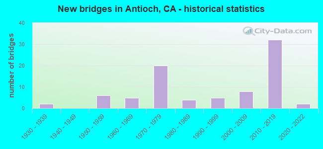
- New bridges - historical statistics
- 21930-1939
- 61950-1959
- 51960-1969
- 201970-1979
- 41980-1989
- 51990-1999
- 82000-2009
- 322010-2019
- 22020-2022
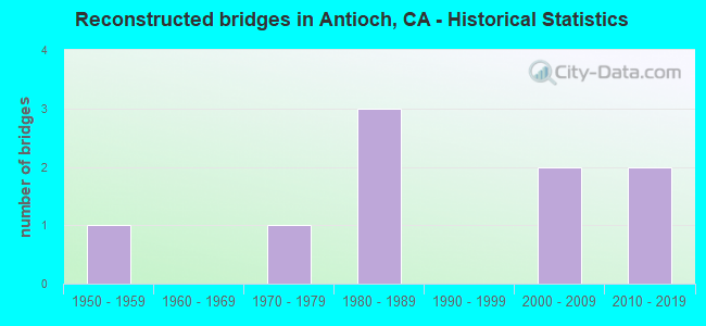
- Reconstructed bridges - Historical Statistics
- 11950-1959
- 01960-1969
- 11970-1979
- 31980-1989
- 01990-1999
- 22000-2009
- 22010-2019
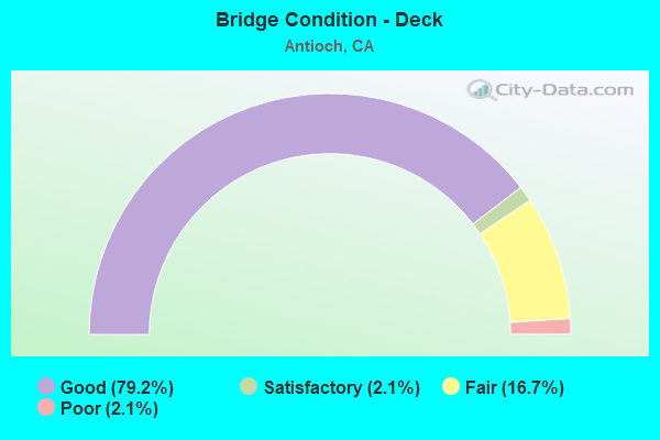
- Bridge Condition - Deck
- 79.2%Good
- 2.1%Satisfactory
- 16.7%Fair
- 2.1%Poor
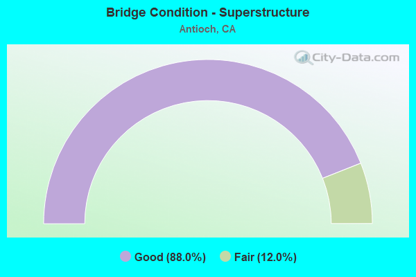
- Bridge Condition - Superstructure
- 88.0%Good
- 12.0%Fair
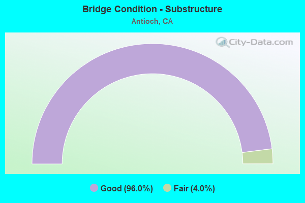
- Bridge Condition - Substructure
- 96.0%Good
- 4.0%Fair
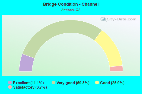
- Bridge Condition - Channel
- 11.1%Excellent
- 59.3%Very good
- 25.9%Good
- 3.7%Satisfactory
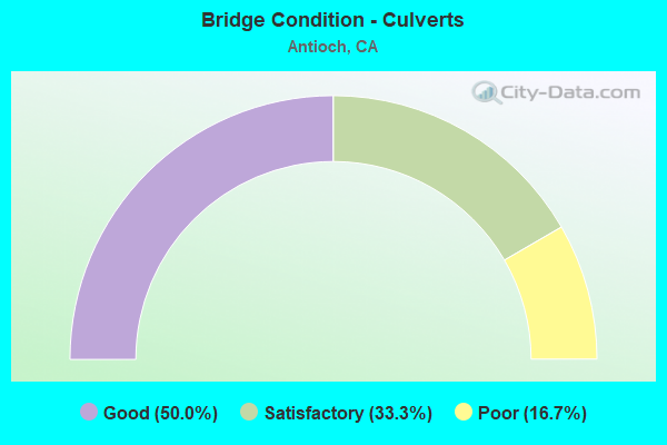
- Bridge Condition - Culverts
- 50.0%Good
- 33.3%Satisfactory
- 16.7%Poor
Find on map >> Show street view
Structure Number: 28C0274, Location: 0.25 MI. S. MARSH CR. RD (Lat: 37.893017, Lng: -121.860983), Route carried "on" structure: County highway , Year Built: 2014, Status: Open, Structure Length: 1.89m (6.20ft), Average Daily Traffic: 150 (year 2014), Truck Traffic: 20%, Average Future Daily Traffic: 212 (year 2037), Design Load: HL 93, Features Intersected: MARSH CREEK, Facility Carried by Structure: CO. JAIL ACCESS RD
Minimum Vertical Clearance: 30+ m (98+ ft), Kilometerpoint: 0.000, Lanes on structure: 2, Owner: County Highway Agency, Approaching Roadway Width: 4.9m (16.1ft), Material/Design: Prestressed concrete, Design/Construction: Slab, Number Of Spans In Main Unit: 1, Length of Maximum Span: 17.5m (57.4ft), Curb or Sidewalk Widths: Left: 0.2m (0.7ft), Right: 0.2m (0.7ft), Curb-To-Curb Width: 4.9m (16.1ft), Out-to-Out Width: 5.3m (17.4ft)
Condition: Deck: Good, Superstructure: Good, Substructure: Good, Channel: Good, Operating Rating: 42.1 metric tons, Method Used To Determine Operating Rating: Assigned ratings based on Load and Resistance Factor Design (LRFD) reported by rating factor (RF) using HL93 loadings, Inventory Rating: 32.4 metric tons, Method Used To Determine Inventory Rating: Assigned ratings based on Load and Resistance Factor Design (LRFD) reported by rating factor (RF) using HL93 loadings, Structural Evaluation: Better than present minimum criteria, Deck Geometry: High priority of replacement, Waterway Adequacy: Better than present minimum criteria, Approach Roadway Alignment: Equal to present desirable criteria, Designated Inspection Frequency: Every 24 months, Inspection Date: July 2020, Deck Structure Type: Concrete Cast-file-Place
Find on map >> Show street view
Structure Number: 28C0285, Location: 0.2 MI N BUCHANAN RD (Lat: 38.000172, Lng: -121.873800), Route carried "on" structure: City street , Year Built: 1970, Status: Open, Structure Length: 1.13m (3.71ft), Average Daily Traffic: 1,500 (year 1998), Truck Traffic: 5%, Average Future Daily Traffic: 2,195 (year 2043), Design Load: HS 20, Features Intersected: CONTRA COSTA CANAL, Facility Carried by Structure: LOVERIDGE ROAD
Minimum Vertical Clearance: 30+ m (98+ ft), Kilometerpoint: 0.000, Lanes on structure: 4, Owner: City or Municipal Highway Agency, Approaching Roadway Width: 19.5m (64.0ft), Skew: 2 degrees, Material/Design: Concrete, Design/Construction: Slab, Number Of Spans In Main Unit: 1, Length of Maximum Span: 10.7m (35.1ft), Curb or Sidewalk Widths: Left: 1.3m (4.3ft), Right: 1.3m (4.3ft), Curb-To-Curb Width: 24.5m (80.4ft), Out-to-Out Width: 28.5m (93.5ft)
Condition: Deck: Good, Superstructure: Good, Substructure: Good, Channel: Very good, Operating Rating: 75.2 metric tons, Method Used To Determine Operating Rating: Load Factor (LF), Inventory Rating: 45.0 metric tons, Method Used To Determine Inventory Rating: Load Factor (LF), Structural Evaluation: Better than present minimum criteria, Deck Geometry: Superior to present desirable criteria, Waterway Adequacy: Superior to present desirable criteria, Approach Roadway Alignment: Equal to present minimum criteria, Designated Inspection Frequency: Every 48 months, Inspection Date: January 2021, Deck Structure Type: Concrete Cast-file-Place, Wearing Surface/Protective System: Wearing Surface: Bituminous
Find on map >> Show street view
Structure Number: 28C0286, Location: 0.4 MI W SOMERSVILLE RD (Lat: 37.997944, Lng: -121.850775), Route carried "on" structure: City street , Year Built: 1938, Year Reconstructed: 1956, Status: Open, Structure Length: 0.91m (2.99ft), Average Daily Traffic: 5,500 (year 1998), Truck Traffic: 5%, Average Future Daily Traffic: 5,453 (year 2041), Features Intersected: CONTRA COSTA CANAL, Facility Carried by Structure: BUCHANAN RD
Minimum Vertical Clearance: 30+ m (98+ ft), Kilometerpoint: 0.000, Lanes on structure: 2, Base Highway Network: Yes, Owner: City or Municipal Highway Agency, Approaching Roadway Width: 12.0m (39.4ft), Skew: 1 degrees, Material/Design: Concrete, Design/Construction: Tee Beam, Number Of Spans In Main Unit: 1, Length of Maximum Span: 8.5m (27.9ft), Curb or Sidewalk Widths: Left: 0.5m (1.6ft), Right: 0.5m (1.6ft), Curb-To-Curb Width: 19.5m (64.0ft), Out-to-Out Width: 20.7m (67.9ft)
Condition: Deck: Good, Superstructure: Good, Substructure: Good, Channel: Good, Operating Rating: 28.5 metric tons, Method Used To Determine Operating Rating: Load and Resistance Factor Rating (LRFR) rating reported by rating factor(RF) method using HL-93 loadings, Inventory Rating: 19.8 metric tons, Method Used To Determine Inventory Rating: Load and Resistance Factor Rating (LRFR) rating reported by rating factor(RF) method using HL-93 loadings, Structural Evaluation: Somewhat better than minimum adequacy, Deck Geometry: Superior to present desirable criteria, Waterway Adequacy: Superior to present desirable criteria, Approach Roadway Alignment: Better than present minimum criteria, Designated Inspection Frequency: Every 24 months, Inspection Date: January 2021, Deck Structure Type: Concrete Cast-file-Place, Wearing Surface/Protective System: Wearing Surface: Bituminous
Find on map >> Show street view
Structure Number: 28C029, Location: AT 'G' STREET (Lat: 37.994031, Lng: -121.817944), Route carried "on" structure: City street , Year Built: 1973, Status: Open, Structure Length: 0.79m (2.59ft), Average Daily Traffic: 4,490 (year 1977), Truck Traffic: 3%, Average Future Daily Traffic: 10,290 (year 2037), Design Load: HS 20, Features Intersected: WEST ANTIOCH CREEK, Facility Carried by Structure: PUTNAM STREET
Minimum Vertical Clearance: 30+ m (98+ ft), Kilometerpoint: 0.000, Lanes on structure: 2, Owner: City or Municipal Highway Agency, Approaching Roadway Width: 12.2m (40.0ft), Skew: 1 degrees, Material/Design: Concrete continuous, Design/Construction: Culvert, Number Of Spans In Main Unit: 2, Length of Maximum Span: 3.9m (12.8ft), Curb or Sidewalk Widths: Left: 1.8m (5.9ft), Right: 1.5m (4.9ft), Curb-To-Curb Width: 12.2m (40.0ft), Out-to-Out Width: 16.1m (52.8ft)
Condition: Channel: Very good, Culverts: Satisfactory, Operating Rating: 54.1 metric tons, Method Used To Determine Operating Rating: Field evaluation and documented engineering judgment, Inventory Rating: 32.4 metric tons, Method Used To Determine Inventory Rating: Field evaluation and documented engineering judgment, Structural Evaluation: Equal to present minimum criteria, Deck Geometry: Equal to present minimum criteria, Waterway Adequacy: Equal to present desirable criteria, Approach Roadway Alignment: Equal to present minimum criteria, Designated Inspection Frequency: Every 48 months, Inspection Date: January 2019
Find on map >> Show street view
Structure Number: 28C0291, Location: 0.4 MI N/O SR4 INTCH (Lat: 38.003328, Lng: -121.815064), Route carried "on" structure: City street , Year Built: 1967, Status: Open, Structure Length: 4.82m (15.81ft), Average Daily Traffic: 6,100 (year 1977), Truck Traffic: 3%, Average Future Daily Traffic: 10,428 (year 2041), Design Load: HS 20, Features Intersected: UP RR, Facility Carried by Structure: G ST
Minimum Vertical Clearance: 30+ m (98+ ft), Kilometerpoint: 0.000, Lanes on structure: 2, Owner: City or Municipal Highway Agency, Approaching Roadway Width: 13.4m (44.0ft), Skew: 1 degrees, Material/Design: Prestressed concrete continuous, Design/Construction: Stringer/Multi-beam, Number Of Spans In Main Unit: 3, Length of Maximum Span: 21.6m (70.9ft), Curb or Sidewalk Widths: Left: 1.5m (4.9ft), Right: 1.5m (4.9ft), Curb-To-Curb Width: 13.4m (44.0ft), Out-to-Out Width: 17.1m (56.1ft)
Condition: Deck: Fair, Superstructure: Good, Substructure: Good, Operating Rating: 42.4 metric tons, Method Used To Determine Operating Rating: Load and Resistance Factor Rating (LRFR) rating reported by rating factor(RF) method using HL-93 loadings, Inventory Rating: 31.4 metric tons, Method Used To Determine Inventory Rating: Load and Resistance Factor Rating (LRFR) rating reported by rating factor(RF) method using HL-93 loadings, Structural Evaluation: Better than present minimum criteria, Deck Geometry: Equal to present minimum criteria, Underclear: Superior to present desirable criteria, Approach Roadway Alignment: Equal to present minimum criteria, Designated Inspection Frequency: Every 24 months, Inspection Date: January 2021, Deck Structure Type: Concrete Cast-file-Place
Find on map >> Show street view
Structure Number: 28C0293, Location: 0.1 MI S WILBUR AVE (Lat: 38.010447, Lng: -121.796522), Route carried "on" structure: City street , Year Built: 1961, Year Reconstructed: 1986, Status: Open, Structure Length: 1.04m (3.41ft), Average Daily Traffic: 4,100 (year 1998), Truck Traffic: 5%, Average Future Daily Traffic: 6,586 (year 2041), Features Intersected: E ANTIOCH CR, Facility Carried by Structure: CAVALLO RD
Minimum Vertical Clearance: 30+ m (98+ ft), Kilometerpoint: 0.000, Lanes on structure: 4, Owner: City or Municipal Highway Agency, Approaching Roadway Width: 18.2m (59.7ft), Material/Design: Concrete continuous, Design/Construction: Culvert, Number Of Spans In Main Unit: 3, Length of Maximum Span: 3.1m (10.2ft), Curb or Sidewalk Widths: Left: 2.7m (8.9ft), Right: 2.7m (8.9ft), Curb-To-Curb Width: 18.2m (59.7ft), Out-to-Out Width: 24.4m (80.1ft)
Condition: Channel: Very good, Culverts: Good, Operating Rating: 37.6 metric tons, Method Used To Determine Operating Rating: Load Factor (LF), Inventory Rating: 22.7 metric tons, Method Used To Determine Inventory Rating: Load Factor (LF), Structural Evaluation: Equal to present minimum criteria, Deck Geometry: Somewhat better than minimum adequacy, Waterway Adequacy: Equal to present desirable criteria, Approach Roadway Alignment: Equal to present minimum criteria, Designated Inspection Frequency: Every 24 months, Inspection Date: January 2021
Find on map >> Show street view
Structure Number: 28C0294, Location: 0.2 MI N OF E 18TH ST (Lat: 38.006386, Lng: -121.787800), Route carried "on" structure: City street , Year Built: 1958, Status: Open, Structure Length: 0.98m (3.22ft), Average Daily Traffic: 4,000 (year 2006), Truck Traffic: 3%, Average Future Daily Traffic: 8,580 (year 2041), Features Intersected: GILLIPPI GULCH, Facility Carried by Structure: HILLCREST AVE
Minimum Vertical Clearance: 30+ m (98+ ft), Kilometerpoint: 0.000, Lanes on structure: 2, Owner: City or Municipal Highway Agency, Approaching Roadway Width: 11.4m (37.4ft), Material/Design: Concrete continuous, Design/Construction: Culvert, Number Of Spans In Main Unit: 4, Length of Maximum Span: 2.4m (7.9ft), Curb or Sidewalk Widths: Left: 2.5m (8.2ft), Right: 0.5m (1.6ft), Curb-To-Curb Width: 11.4m (37.4ft), Out-to-Out Width: 14.4m (47.2ft)
Condition: Channel: Very good, Culverts: Satisfactory, Operating Rating: 40.5 metric tons, Method Used To Determine Operating Rating: Field evaluation and documented engineering judgment, Inventory Rating: 24.3 metric tons, Method Used To Determine Inventory Rating: Field evaluation and documented engineering judgment, Structural Evaluation: Equal to present minimum criteria, Deck Geometry: Somewhat better than minimum adequacy, Waterway Adequacy: Equal to present desirable criteria, Approach Roadway Alignment: Somewhat better than minimum adequacy, Designated Inspection Frequency: Every 24 months, Inspection Date: January 2021, Deck Structure Type: Concrete Cast-file-Place, Wearing Surface/Protective System: Wearing Surface: Bituminous
Find on map >> Show street view
Structure Number: 28C0424, Location: AT EAST 13TH ST (Lat: 38.010100, Lng: -121.795794), Route carried "on" structure: City street , Year Built: 1961, Year Reconstructed: 1987, Status: Open, Structure Length: 1.01m (3.31ft), Average Daily Traffic: 1,500 (year 1982), Truck Traffic: 1%, Average Future Daily Traffic: 1,963 (year 2041), Features Intersected: LAKE ALHAMBRA, Facility Carried by Structure: NORTH LAKE DRIVE
Minimum Vertical Clearance: 30+ m (98+ ft), Kilometerpoint: 0.000, Lanes on structure: 2, Owner: City or Municipal Highway Agency, Approaching Roadway Width: 9.1m (29.9ft), Material/Design: Concrete continuous, Design/Construction: Culvert, Number Of Spans In Main Unit: 3, Length of Maximum Span: 3.2m (10.5ft), Curb or Sidewalk Widths: Left: 1.6m (5.2ft), Right: 0.2m (0.7ft), Curb-To-Curb Width: 9.1m (29.9ft), Out-to-Out Width: 11.6m (38.1ft)
Condition: Channel: Very good, Culverts: Poor, Operating Rating: 40.5 metric tons, Method Used To Determine Operating Rating: Field evaluation and documented engineering judgment, Inventory Rating: 24.3 metric tons, Method Used To Determine Inventory Rating: Field evaluation and documented engineering judgment, Structural Evaluation: Meets minimum limits, Deck Geometry: Somewhat better than minimum adequacy, Waterway Adequacy: Equal to present desirable criteria, Approach Roadway Alignment: Meets minimum limits, Length Of Structure Improvement: 1.01m (3.31ft), Designated Inspection Frequency: Every 24 months, Inspection Date: January 2021, Bridge Improvement Cost: $117,000, Roadway Improvement Cost: $23,000, Total Project Cost: $196,000 ( Estimate for 2017), Deck Structure Type: Concrete Cast-file-Place, Wearing Surface/Protective System: Wearing Surface: Bituminous
Find on map >> Show street view
Structure Number: 28C0425, Location: 1.5 MI E SOMERVILLE RD (Lat: 37.982997, Lng: -121.829500), Route carried "on" structure: City street , Year Built: 1950, Year Reconstructed: 1978, Status: Open, Structure Length: 1.09m (3.58ft), Average Daily Traffic: 1,873 (year 1998), Truck Traffic: 2%, Average Future Daily Traffic: 2,180 (year 2041), Features Intersected: CONTRA COSTA CANAL, Facility Carried by Structure: JAMES DONLON BLVD
Minimum Vertical Clearance: 30+ m (98+ ft), Kilometerpoint: 0.000, Lanes on structure: 4, Owner: City or Municipal Highway Agency, Approaching Roadway Width: 19.4m (63.6ft), Skew: 33 degrees, Material/Design: Concrete, Design/Construction: Tee Beam, Number Of Spans In Main Unit: 1, Length of Maximum Span: 10.4m (34.1ft), Curb or Sidewalk Widths: Left: 1.8m (5.9ft), Right: 1.8m (5.9ft), Curb-To-Curb Width: 19.8m (65.0ft), Out-to-Out Width: 28.8m (94.5ft)
Condition: Deck: Good, Superstructure: Good, Substructure: Good, Channel: Very good, Operating Rating: 33.7 metric tons, Method Used To Determine Operating Rating: Field evaluation and documented engineering judgment, Inventory Rating: 20.4 metric tons, Method Used To Determine Inventory Rating: Field evaluation and documented engineering judgment, Structural Evaluation: Somewhat better than minimum adequacy, Deck Geometry: Better than present minimum criteria, Waterway Adequacy: Equal to present desirable criteria, Approach Roadway Alignment: Better than present minimum criteria, Designated Inspection Frequency: Every 24 months, Inspection Date: January 2021, Deck Structure Type: Concrete Cast-file-Place, Wearing Surface/Protective System: Wearing Surface: Bituminous
Find on map >> Show street view
Structure Number: 28C0426, Location: 0.7 MI N JAMES DONLON (Lat: 37.989658, Lng: -121.840150), Route carried "on" structure: City street , Year Built: 1973, Status: Open, Structure Length: 0.94m (3.08ft), Average Daily Traffic: 4,500 (year 1998), Truck Traffic: 1%, Average Future Daily Traffic: 5,489 (year 2043), Design Load: HS 20, Features Intersected: CONTRA COSTA CANAL, Facility Carried by Structure: GENTRYTOWN DRIVE
Minimum Vertical Clearance: 30+ m (98+ ft), Kilometerpoint: 0.000, Lanes on structure: 2, Owner: City or Municipal Highway Agency, Approaching Roadway Width: 12.2m (40.0ft), Material/Design: Concrete, Design/Construction: Tee Beam, Number Of Spans In Main Unit: 1, Length of Maximum Span: 8.5m (27.9ft), Curb or Sidewalk Widths: Left: 1.5m (4.9ft), Right: 1.5m (4.9ft), Curb-To-Curb Width: 12.2m (40.0ft), Out-to-Out Width: 15.8m (51.8ft)
Condition: Deck: Good, Superstructure: Good, Substructure: Good, Channel: Good, Operating Rating: 89.1 metric tons, Method Used To Determine Operating Rating: Load Factor (LF), Inventory Rating: 53.8 metric tons, Method Used To Determine Inventory Rating: Load Factor (LF), Structural Evaluation: Better than present minimum criteria, Deck Geometry: Equal to present minimum criteria, Waterway Adequacy: Superior to present desirable criteria, Approach Roadway Alignment: Equal to present minimum criteria, Designated Inspection Frequency: Every 48 months, Inspection Date: January 2021, Deck Structure Type: Concrete Cast-file-Place, Wearing Surface/Protective System: Wearing Surface: Bituminous
Find on map >> Show street view
Structure Number: 28C0444, Location: AT HILLCREST AVENUE (Lat: 37.982881, Lng: -121.773181), Route carried "on" structure: City street , Year Built: 1984, Status: Open, Structure Length: 1.04m (3.41ft), Average Daily Traffic: 1,500 (year 1998), Truck Traffic: 1%, Average Future Daily Traffic: 2,744 (year 2043), Design Load: HS 20+Mod, Features Intersected: CONTRA COSTA CANAL, Facility Carried by Structure: VIA DORA DRIVE
Minimum Vertical Clearance: 30+ m (98+ ft), Kilometerpoint: 0.000, Lanes on structure: 3, Owner: City or Municipal Highway Agency, Approaching Roadway Width: 12.2m (40.0ft), Material/Design: Prestressed concrete, Design/Construction: Slab, Number Of Spans In Main Unit: 1, Length of Maximum Span: 10.4m (34.1ft), Curb or Sidewalk Widths: Left: 1.8m (5.9ft), Right: 1.8m (5.9ft), Curb-To-Curb Width: 12.2m (40.0ft), Out-to-Out Width: 16.5m (54.1ft)
Condition: Deck: Good, Superstructure: Good, Substructure: Good, Channel: Very good, Operating Rating: 54.1 metric tons, Method Used To Determine Operating Rating: Assigned rating based on Load Factor Design (LFD) reported in metric tons, Inventory Rating: 32.4 metric tons, Method Used To Determine Inventory Rating: Assigned rating based on Load Factor Design (LFD) reported in metric tons, Structural Evaluation: Better than present minimum criteria, Deck Geometry: Meets minimum limits, Waterway Adequacy: Superior to present desirable criteria, Approach Roadway Alignment: Equal to present minimum criteria, Designated Inspection Frequency: Every 48 months, Inspection Date: January 2021, Deck Structure Type: Concrete Cast-file-Place, Wearing Surface/Protective System: Wearing Surface: Bituminous
Find on map >> Show street view
Structure Number: 28C0476, Location: 0.05 MI W OF "O" STREET (Lat: 38.015456, Lng: -121.826017), Route carried "on" structure: City street , Year Built: 1992, Status: Open, Structure Length: 1.39m (4.56ft), Average Daily Traffic: 6,000 (year 1998), Truck Traffic: 5%, Average Future Daily Traffic: 12,911 (year 2037), Features Intersected: WEST ANTIOCH CREEK, Facility Carried by Structure: SOMERSVILLE ROAD
Minimum Vertical Clearance: 30+ m (98+ ft), Kilometerpoint: 0.000, Lanes on structure: 4, Owner: City or Municipal Highway Agency, Approaching Roadway Width: 15.6m (51.2ft), Skew: 31 degrees, Material/Design: Concrete continuous, Design/Construction: Culvert, Number Of Spans In Main Unit: 3, Length of Maximum Span: 4.3m (14.1ft), Curb or Sidewalk Widths: Left: 3.0m (9.8ft), Right: 3.0m (9.8ft), Curb-To-Curb Width: 15.6m (51.2ft), Out-to-Out Width: 34.1m (111.9ft)
Condition: Channel: Very good, Culverts: Good, Operating Rating: 54.1 metric tons, Method Used To Determine Operating Rating: Field evaluation and documented engineering judgment, Inventory Rating: 32.4 metric tons, Method Used To Determine Inventory Rating: Field evaluation and documented engineering judgment, Structural Evaluation: Better than present minimum criteria, Deck Geometry: Meets minimum limits, Waterway Adequacy: Equal to present desirable criteria, Approach Roadway Alignment: Better than present minimum criteria, Designated Inspection Frequency: Every 48 months, Inspection Date: January 2019
Find on map >> Show street view
Structure Number: 28C048, Location: 0.05 MI S RIVERSIDE DRIVE (Lat: 38.027833, Lng: -121.967439), Route carried "on" structure: County highway , Year Built: 1987, Status: Open, Structure Length: 1.22m (4.00ft), Average Daily Traffic: 956 (year 2013), Truck Traffic: 2%, Average Future Daily Traffic: 1,031 (year 2037), Features Intersected: CONTRA COSTA CANAL, Facility Carried by Structure: POMO STREET
Minimum Vertical Clearance: 30+ m (98+ ft), Kilometerpoint: 0.000, Lanes on structure: 2, Owner: County Highway Agency, Approaching Roadway Width: 11.0m (36.1ft), Material/Design: Steel, Design/Construction: Arch - Deck, Number Of Spans In Main Unit: 1, Length of Maximum Span: 9.3m (30.5ft)
Condition: Superstructure: Fair, Substructure: Good, Channel: Excellent, Operating Rating: 54.1 metric tons, Method Used To Determine Operating Rating: Field evaluation and documented engineering judgment, Inventory Rating: 32.4 metric tons, Method Used To Determine Inventory Rating: Field evaluation and documented engineering judgment, Structural Evaluation: Somewhat better than minimum adequacy, Waterway Adequacy: Superior to present desirable criteria, Approach Roadway Alignment: Equal to present desirable criteria, Designated Inspection Frequency: Every 24 months, Inspection Date: November 2020
Find on map >> Show street view
Structure Number: 28C0493, Location: 0.1 MI S OF DAVISON DR (Lat: 37.984117, Lng: -121.798114), Route carried "on" structure: City street , Year Built: 1991, Status: Open, Structure Length: 1.22m (4.00ft), Average Daily Traffic: 4,500 (year 1998), Average Future Daily Traffic: 5,545 (year 2041), Features Intersected: CONTRA COSTA CANAL, Facility Carried by Structure: GARROW DRIVE
Minimum Vertical Clearance: 30+ m (98+ ft), Kilometerpoint: 0.000, Lanes on structure: 2, Owner: City or Municipal Highway Agency, Approaching Roadway Width: 12.2m (40.0ft), Material/Design: Prestressed concrete, Design/Construction: Tee Beam, Number Of Spans In Main Unit: 1, Length of Maximum Span: 11.9m (39.0ft), Curb or Sidewalk Widths: Left: 1.5m (4.9ft), Right: 1.5m (4.9ft), Curb-To-Curb Width: 12.2m (40.0ft), Out-to-Out Width: 15.9m (52.2ft)
Condition: Deck: Good, Superstructure: Good, Substructure: Good, Channel: Good, Operating Rating: 54.1 metric tons, Method Used To Determine Operating Rating: Field evaluation and documented engineering judgment, Inventory Rating: 32.4 metric tons, Method Used To Determine Inventory Rating: Field evaluation and documented engineering judgment, Structural Evaluation: Better than present minimum criteria, Deck Geometry: Equal to present minimum criteria, Waterway Adequacy: Superior to present desirable criteria, Approach Roadway Alignment: Equal to present desirable criteria, Designated Inspection Frequency: Every 48 months, Inspection Date: January 2019, Deck Structure Type: Concrete Cast-file-Place, Wearing Surface/Protective System: Wearing Surface: Bituminous
Find on map >> Show street view
Structure Number: 28C0495, Location: 2.9 MI W DEER VALLEY RD (Lat: 37.909806, Lng: -121.814733), Route carried "on" structure: County highway , Year Built: 2001, Status: Open, Structure Length: 1.35m (4.43ft), Average Daily Traffic: 50 (year 2014), Average Future Daily Traffic: 150 (year 2037), Features Intersected: BRIONES VALLEY CREEK, Facility Carried by Structure: BRIONES VALLEY RD
Minimum Vertical Clearance: 30+ m (98+ ft), Kilometerpoint: 0.000, Lanes on structure: 1, Owner: County Highway Agency, Approaching Roadway Width: 4.3m (14.1ft), Material/Design: Steel, Design/Construction: Truss - Thru, Number Of Spans In Main Unit: 1, Number Of Approach Spans: 4, Length of Maximum Span: 12.3m (40.4ft), Curb-To-Curb Width: 4.2m (13.8ft), Out-to-Out Width: 4.2m (13.8ft)
Condition: Deck: Poor, Superstructure: Fair, Substructure: Fair, Channel: Good, Operating Rating: 36.9 metric tons, Method Used To Determine Operating Rating: Load Factor (LF), Inventory Rating: 22.0 metric tons, Method Used To Determine Inventory Rating: Load Factor (LF), Structural Evaluation: Somewhat better than minimum adequacy, Deck Geometry: Somewhat better than minimum adequacy, Waterway Adequacy: Better than present minimum criteria, Approach Roadway Alignment: Equal to present desirable criteria, Length Of Structure Improvement: 1.35m (4.43ft), Designated Inspection Frequency: Every 24 months, Critical Feature Inspection Frequency: Every 24 months, Inspection Date: July 2020, Critical Feature Inspection Date: July 2020, Bridge Improvement Cost: $131,000, Roadway Improvement Cost: $26,000, Total Project Cost: $220,000 ( Estimate for 2017), Deck Structure Type: Open Grating
Find on map >> Show street view
Structure Number: 28C05, Location: 1 MI. S. OF HWY 4 (Lat: 37.984719, Lng: -121.785353), Route carried "on" structure: City street , Year Built: 1988, Status: Open, Structure Length: 1.50m (4.92ft), Average Daily Traffic: 1,000 (year 2016), Truck Traffic: 1%, Average Future Daily Traffic: 1,525 (year 2038), Features Intersected: CONTRA COSTA CANAL, Facility Carried by Structure: DEER VALLEY ROAD
Minimum Vertical Clearance: 30+ m (98+ ft), Kilometerpoint: 0.000, Lanes on structure: 4, Owner: City or Municipal Highway Agency, Approaching Roadway Width: 19.4m (63.6ft), Skew: 30 degrees, Material/Design: Prestressed concrete, Design/Construction: Slab, Number Of Spans In Main Unit: 1, Length of Maximum Span: 14.2m (46.6ft), Curb or Sidewalk Widths: Left: 2.7m (8.9ft), Right: 2.7m (8.9ft), Curb-To-Curb Width: 19.4m (63.6ft), Out-to-Out Width: 30.4m (99.7ft)
Condition: Deck: Good, Superstructure: Good, Substructure: Good, Channel: Very good, Operating Rating: 54.1 metric tons, Method Used To Determine Operating Rating: Field evaluation and documented engineering judgment, Inventory Rating: 32.4 metric tons, Method Used To Determine Inventory Rating: Field evaluation and documented engineering judgment, Structural Evaluation: Better than present minimum criteria, Deck Geometry: Better than present minimum criteria, Waterway Adequacy: Equal to present desirable criteria, Approach Roadway Alignment: Equal to present desirable criteria, Designated Inspection Frequency: Every 48 months, Inspection Date: January 2021, Deck Structure Type: Concrete Cast-file-Place, Wearing Surface/Protective System: Wearing Surface: Bituminous
Find on map >> Show street view
Structure Number: 28C0506, Location: 0.03 MI S JAMES DONLON BL (Lat: 37.979819, Lng: -121.820461), Route carried "on" structure: City street , Year Built: 1989, Status: Open, Structure Length: 1.08m (3.54ft), Average Daily Traffic: 1,000 (year 2006), Truck Traffic: 5%, Average Future Daily Traffic: 1,224 (year 2041), Design Load: HS 20, Features Intersected: CONTRA COSTA CANAL, Facility Carried by Structure: BLYTHE DRIVE
Minimum Vertical Clearance: 30+ m (98+ ft), Kilometerpoint: 0.000, Lanes on structure: 2, Owner: City or Municipal Highway Agency, Approaching Roadway Width: 8.5m (27.9ft), Material/Design: Prestressed concrete, Design/Construction: Slab, Number Of Spans In Main Unit: 1, Length of Maximum Span: 10.8m (35.4ft), Curb or Sidewalk Widths: Left: 1.5m (4.9ft), Right: 1.5m (4.9ft), Curb-To-Curb Width: 8.5m (27.9ft), Out-to-Out Width: 12.2m (40.0ft)
Condition: Deck: Good, Superstructure: Good, Substructure: Good, Channel: Very good, Operating Rating: 54.1 metric tons, Method Used To Determine Operating Rating: Assigned rating based on Load Factor Design (LFD) reported in metric tons, Inventory Rating: 32.4 metric tons, Method Used To Determine Inventory Rating: Assigned rating based on Load Factor Design (LFD) reported in metric tons, Structural Evaluation: Better than present minimum criteria, Deck Geometry: Somewhat better than minimum adequacy, Waterway Adequacy: Equal to present desirable criteria, Approach Roadway Alignment: Equal to present desirable criteria, Designated Inspection Frequency: Every 48 months, Inspection Date: January 2019, Deck Structure Type: Concrete Cast-file-Place, Wearing Surface/Protective System: Wearing Surface: Bituminous
Find on map >> Show street view
Structure Number: 28 0030L, Location: 04-CC-160-0.50 (Lat: 38.012075, Lng: -121.752239), Route carried "under" structure: County highway , Year Built: 1971, Structure Length: 0. m, Average Daily Traffic: 23,000 (year 2018), Truck Traffic: 1%, Features Intersected: WILBUR AVENUE, Facility Carried by Structure: SR 160 SB
Minimum Vertical Clearance: 5.18m (16.99ft), Kilometerpoint: 0.000, Lanes on structure: 2, Lanes under structure: 5, Material/Design: Prestressed concrete, Design/Construction: Box Beam or Girders - Multiple, Length of Maximum Span: 47.5m (155.8ft)
Find on map >> Show street view
Structure Number: 28 0041L, Location: 04-CC-160-0.00 (Lat: 38.004908, Lng: -121.753903), Route carried "under" structure: County highway , Year Built: 1971, Structure Length: 0. m, Average Daily Traffic: 36,700 (year 2018), Truck Traffic: 4%, Features Intersected: E 18TH STREET, Facility Carried by Structure: SR 160 SB
Minimum Vertical Clearance: 5.92m (19.42ft), Kilometerpoint: 0.000, Lanes on structure: 3, Lanes under structure: 6, Material/Design: Prestressed concrete, Design/Construction: Box Beam or Girders - Multiple, Length of Maximum Span: 48.8m (160.1ft)
Find on map >> Show street view
Structure Number: 28 0041R, Location: 04-CC-160-0.00 (Lat: 38.004911, Lng: -121.753519), Route carried "under" structure: County highway , Year Built: 1971, Structure Length: 0. m, Average Daily Traffic: 36,700 (year 2018), Truck Traffic: 4%, Features Intersected: E 18TH STREET, Facility Carried by Structure: SR 160 NB
Minimum Vertical Clearance: 6.30m (20.67ft), Kilometerpoint: 0.000, Lanes on structure: 3, Lanes under structure: 6, Material/Design: Prestressed concrete, Design/Construction: Box Beam or Girders - Multiple, Length of Maximum Span: 48.8m (160.1ft)
Find on map >> Show street view
Structure Number: 28 0109, Location: 04-CC-160-0.48 (Lat: 37.997728, Lng: -121.755861), Route carried "under" structure: State highway 160, Year Built: 1971, Structure Length: 0. m, Average Daily Traffic: 23,900 (year 2018), Truck Traffic: 8%, Features Intersected: STATE ROUTE 160, Facility Carried by Structure: OAKLEY ROAD
Minimum Vertical Clearance: 5.13m (16.83ft), Kilometerpoint: 0.480, Lanes on structure: 2, Lanes under structure: 6, Material/Design: Prestressed concrete continuous, Design/Construction: Box Beam or Girders - Multiple, Length of Maximum Span: 34.7m (113.8ft)
Find on map >> Show street view
Structure Number: 28 0183L, Location: 04-CC-004-R28.94-ANT (Lat: 37.996547, Lng: -121.785564), Route carried "under" structure: State highway 4, Year Built: 1997, Structure Length: 0. m, Average Daily Traffic: 94,000 (year 2017), Truck Traffic: 8%, Features Intersected: STATE ROUTE 4, Facility Carried by Structure: HILLCREST AVE NB
Minimum Vertical Clearance: 4.92m (16.14ft), Kilometerpoint: 28.940, Lanes on structure: 4, Lanes under structure: 8, Material/Design: Prestressed concrete continuous, Design/Construction: Box Beam or Girders - Multiple, Length of Maximum Span: 40.3m (132.2ft)
Find on map >> Show street view
Structure Number: 28 0183R, Location: 04-CC-004-R28.90-ANT (Lat: 37.996544, Lng: -121.785750), Route carried "under" structure: State highway 4, Year Built: 1971, Structure Length: 0. m, Average Daily Traffic: 94,000 (year 2017), Truck Traffic: 8%, Features Intersected: STATE ROUTE 4, Facility Carried by Structure: HILLCREST AVE SB
Minimum Vertical Clearance: 4.92m (16.14ft), Kilometerpoint: 28.900, Lanes on structure: 5, Lanes under structure: 8, Material/Design: Prestressed concrete continuous, Design/Construction: Box Beam or Girders - Multiple, Length of Maximum Span: 36.6m (120.1ft)
Find on map >> Show street view
Structure Number: 28 0388G, Location: 04-CC-004-R30.20-ANT (Lat: 37.990767, Lng: -121.758681), Route carried "under" structure: State highway 4, Year Built: 2005, Structure Length: 0. m, Average Daily Traffic: 45,000 (year 2017), Truck Traffic: 8%, Features Intersected: STATE ROUTE 4
Minimum Vertical Clearance: 5.43m (17.81ft), Kilometerpoint: 30.200, Lanes on structure: 2, Lanes under structure: 6, Material/Design: Prestressed concrete continuous, Design/Construction: Box Beam or Girders - Multiple, Length of Maximum Span: 53.4m (175.2ft)
Find on map >> Show street view
Structure Number: 28 039, Location: 04-CC-004-R31.37-ANT (Lat: 37.979225, Lng: -121.743867), Route carried "under" structure: State highway 4, Year Built: 2008, Structure Length: 0. m, Average Daily Traffic: 40,000 (year 2019), Truck Traffic: 10%, Features Intersected: STATE ROUTE 4, Facility Carried by Structure: LAUREL ROAD
Minimum Vertical Clearance: 5.56m (18.24ft), Kilometerpoint: 31.370, Lanes on structure: 5, Lanes under structure: 5, Material/Design: Prestressed concrete continuous, Design/Construction: Box Beam or Girders - Multiple, Length of Maximum Span: 44.1m (144.7ft)
Find on map >> Show street view
Structure Number: 28 0398K, Location: 04-CC-004-26.01-ANT (Lat: 38.004181, Lng: -121.837533), Route carried "under" structure: City street , Year Built: 2012, Structure Length: 0. m, Average Daily Traffic: 65,000 (year 2017), Truck Traffic: 8%, Features Intersected: SOMERSVILLE ROAD, Facility Carried by Structure: WB ROUTE 4 OFFRAMP
Minimum Vertical Clearance: 5.89m (19.32ft), Kilometerpoint: 0.000, Lanes on structure: 1, Lanes under structure: 8, Material/Design: Prestressed concrete continuous, Design/Construction: Box Beam or Girders - Multiple, Length of Maximum Span: 36.1m (118.4ft)
Find on map >> Show street view
Structure Number: 28 0398L, Location: 04-CC-004-26.01-ANT (Lat: 38.003997, Lng: -121.837814), Route carried "under" structure: City street , Year Built: 2013, Structure Length: 0. m, Average Daily Traffic: 65,000 (year 2017), Truck Traffic: 8%, Features Intersected: SOMERSVILLE ROAD, Facility Carried by Structure: STATE ROUTE 4 WB
Minimum Vertical Clearance: 6.37m (20.90ft), Kilometerpoint: 0.000, Lanes on structure: 4, Lanes under structure: 9, Material/Design: Prestressed concrete continuous, Design/Construction: Box Beam or Girders - Multiple, Length of Maximum Span: 37.2m (122.0ft)
Find on map >> Show street view
Structure Number: 28 0398R, Location: 04-CC-004-26.01-ANT (Lat: 38.003767, Lng: -121.837828), Route carried "under" structure: City street , Year Built: 2013, Structure Length: 0. m, Average Daily Traffic: 65,000 (year 2017), Truck Traffic: 8%, Features Intersected: SOMERSVILLE ROAD, Facility Carried by Structure: STATE ROUTE 4 EB
Minimum Vertical Clearance: 5.68m (18.64ft), Kilometerpoint: 0.000, Lanes on structure: 4, Lanes under structure: 8, Material/Design: Prestressed concrete continuous, Design/Construction: Box Beam or Girders - Multiple, Length of Maximum Span: 37.2m (122.0ft)
Find on map >> Show street view
Structure Number: 28 0399L, Location: 04-CC-004-26.93-ANT (Lat: 37.999583, Lng: -121.821139), Route carried "under" structure: City street , Year Built: 2015, Structure Length: 0. m, Average Daily Traffic: 12,445 (year 2016), Truck Traffic: 5%, Features Intersected: CONTRA LOMA BLVD, Facility Carried by Structure: STATE ROUTE 4 WB
Minimum Vertical Clearance: 4.57m (14.99ft), Kilometerpoint: 0.000, Lanes on structure: 4, Lanes under structure: 7, Material/Design: Prestressed concrete, Design/Construction: Slab, Length of Maximum Span: 24.0m (78.7ft)
Find on map >> Show street view
Structure Number: 28 0399R, Location: 04-CC-004-26.93-ANT (Lat: 37.999139, Lng: -121.821333), Route carried "under" structure: City street , Year Built: 2015, Structure Length: 0. m, Average Daily Traffic: 12,445 (year 2016), Truck Traffic: 5%, Features Intersected: CONTRA LOMA BLVD, Facility Carried by Structure: STATE ROUTE 4 EB
Minimum Vertical Clearance: 4.57m (14.99ft), Kilometerpoint: 0.000, Lanes on structure: 4, Lanes under structure: 7, Material/Design: Prestressed concrete, Design/Construction: Slab, Length of Maximum Span: 24.0m (78.7ft)
Find on map >> Show street view
Structure Number: 28 04, Location: 04-CC-004-27.29-ANT (Lat: 37.998342, Lng: -121.815281), Route carried "under" structure: State highway 4, Year Built: 2014, Structure Length: 0. m, Average Daily Traffic: 114,000 (year 2019), Truck Traffic: 8%, Features Intersected: STATE ROUTE 4, Facility Carried by Structure: G STREET
Minimum Vertical Clearance: 5.13m (16.83ft), Kilometerpoint: 27.290, Lanes on structure: 3, Lanes under structure: 10, Material/Design: Prestressed concrete continuous, Design/Construction: Box Beam or Girders - Multiple, Length of Maximum Span: 44.0m (144.4ft)
Find on map >> Show street view
Structure Number: 28 0401L, Location: 04-CC-004-R27.78-ANT (Lat: 37.998444, Lng: -121.806319), Route carried "under" structure: City street , Year Built: 2016, Structure Length: 0. m, Average Daily Traffic: 28,921 (year 2016), Truck Traffic: 5%, Features Intersected: A STREET, Facility Carried by Structure: STATE ROUTE 4 WB
Minimum Vertical Clearance: 5.68m (18.64ft), Kilometerpoint: 0.000, Lanes on structure: 4, Lanes under structure: 8, Material/Design: Prestressed concrete continuous, Design/Construction: Box Beam or Girders - Multiple, Length of Maximum Span: 30.1m (98.8ft)
Find on map >> Show street view
Structure Number: 28 0401R, Location: 04-CC-004-R27.78-ANT (Lat: 37.998003, Lng: -121.806289), Route carried "under" structure: City street , Year Built: 2016, Structure Length: 0. m, Average Daily Traffic: 28,921 (year 2016), Truck Traffic: 5%, Features Intersected: A STREET, Facility Carried by Structure: STATE ROUTE 4 EB
Minimum Vertical Clearance: 5.38m (17.65ft), Kilometerpoint: 0.000, Lanes on structure: 4, Lanes under structure: 8, Material/Design: Prestressed concrete continuous, Design/Construction: Box Beam or Girders - Multiple, Length of Maximum Span: 30.1m (98.8ft)
Find on map >> Show street view
Structure Number: 28 0402L, Location: 04-CC-004-R28.23-ANT (Lat: 37.998481, Lng: -121.798194), Route carried "under" structure: City street , Year Built: 2016, Structure Length: 0. m, Average Daily Traffic: 10,000 (year 2016), Truck Traffic: 4%, Features Intersected: CAVALLO ROAD, Facility Carried by Structure: STATE ROUTE 4 WB
Minimum Vertical Clearance: 5.51m (18.08ft), Kilometerpoint: 0.000, Lanes on structure: 5, Lanes under structure: 2, Material/Design: Prestressed concrete, Design/Construction: Box Beam or Girders - Multiple, Length of Maximum Span: 38.9m (127.6ft)
Find on map >> Show street view
Structure Number: 28 0402R, Location: 04-CC-004-R28.23-ANT (Lat: 37.997956, Lng: -121.798194), Route carried "under" structure: City street , Year Built: 2016, Structure Length: 0. m, Average Daily Traffic: 10,000 (year 2016), Truck Traffic: 4%, Features Intersected: CAVALLO ROAD, Facility Carried by Structure: STATE ROUTE 4 EB
Minimum Vertical Clearance: 4.69m (15.39ft), Kilometerpoint: 0.000, Lanes on structure: 5, Lanes under structure: 2, Material/Design: Prestressed concrete, Design/Construction: Box Beam or Girders - Multiple, Length of Maximum Span: 38.9m (127.6ft)
Find on map >> Show street view
Structure Number: 28 0407L, Location: 04-CC-004-R29.23-ANT (Lat: 37.995583, Lng: -121.780389), Route carried "under" structure: State highway 4, Year Built: 2016, Structure Length: 0. m, Average Daily Traffic: 47,000 (year 2019), Truck Traffic: 8%, Features Intersected: STATE ROUTE 4 WB, Facility Carried by Structure: PEDESTRIAN ACCESS
Minimum Vertical Clearance: 6.60m (21.65ft), Kilometerpoint: 29.230, Lanes under structure: 4, Material/Design: Steel continuous, Design/Construction: Truss - Thru, Length of Maximum Span: 39.6m (129.9ft)
Find on map >> Show street view
Structure Number: 28 0409F, Location: 04-CC-160-L0.41R-ANT (Lat: 37.991611, Lng: -121.756639), Route carried "under" structure: State highway 160, Year Built: 2016, Structure Length: 0. m, Average Daily Traffic: 13,600 (year 2018), Truck Traffic: 7%, Features Intersected: E4-N160 CONNECT, UPRR
Minimum Vertical Clearance: 5.97m (19.59ft), Kilometerpoint: 0.440, Lanes on structure: 2, Lanes under structure: 2, Material/Design: Prestressed concrete continuous, Design/Construction: Box Beam or Girders - Multiple, Length of Maximum Span: 67.1m (220.1ft)
Find on map >> Show street view
Structure Number: 28 0410F, Location: 04-CC-160-L0.40R-ANT (Lat: 37.990578, Lng: -121.756142), Route carried "under" structure: State highway 4, Year Built: 2016, Structure Length: 0. m, Average Daily Traffic: 23,900 (year 2018), Truck Traffic: 8%, Features Intersected: ROUTE 4
Minimum Vertical Clearance: 8.89m (29.17ft), Kilometerpoint: 30.660, Lanes on structure: 2, Lanes under structure: 6, Material/Design: Prestressed concrete continuous, Design/Construction: Box Beam or Girders - Multiple, Length of Maximum Span: 58.7m (192.6ft)
Find on map >> Show street view
Structure Number: 28 0420R, Location: 04-CC-160-0.70 (Lat: 38.015078, Lng: -121.751500), Route carried "under" structure: State highway 160, Year Built: 1978, Structure Length: 0. m, Average Daily Traffic: 6,650 (year 2016), Truck Traffic: 7%, Features Intersected: STATE ROUTE 160 NB, Facility Carried by Structure: NONE
Minimum Vertical Clearance: 5.18m (16.99ft), Kilometerpoint: 0.700, Lanes under structure: 3, Toll: On toll road, Material/Design: Steel, Design/Construction: Box Beam or Girders - Multiple, Length of Maximum Span: 10.4m (34.1ft)
Find on map >> Show street view
Structure Number: 28C0288, Location: AT SPT UNDERPASS (Lat: 38.004481, Lng: -121.820239), Route carried "under" structure: City street , Year Built: 1960, Structure Length: 0. m, Average Daily Traffic: 17,673 (year 1998), Truck Traffic: 3%, Features Intersected: PIPE OC (L STREET), Facility Carried by Structure: PIPE OC
Minimum Vertical Clearance: 6.50m (21.33ft), Kilometerpoint: 0.000, Lanes under structure: 4, Material/Design: Steel, Length of Maximum Span: 11.2m (36.7ft)
Find on map >> Show street view
Structure Number: 28C0289, Location: 0.4 MI N/O SR4 (Lat: 38.004608, Lng: -121.820153), Route carried "under" structure: City street , Year Built: 1968, Structure Length: 0. m, Average Daily Traffic: 17,673 (year 1998), Truck Traffic: 3%, Features Intersected: L STREET, Facility Carried by Structure: UP RR
Minimum Vertical Clearance: 4.52m (14.83ft), Kilometerpoint: 0.000, Lanes under structure: 4, Material/Design: Steel continuous, Design/Construction: Stringer/Multi-beam, Length of Maximum Span: 9.9m (32.5ft)
Find on map >> Show street view
Structure Number: 28C0292, Location: 0.2 MI N/O SR4 (Lat: 37.999975, Lng: -121.797447), Route carried "under" structure: City street , Year Built: 1976, Structure Length: 0. m, Average Daily Traffic: 1,000 (year 1977), Truck Traffic: 1%, Features Intersected: CAVALLO ROAD, Facility Carried by Structure: UP RR
Minimum Vertical Clearance: 4.65m (15.26ft), Kilometerpoint: 0.000, Lanes under structure: 2, Material/Design: Prestressed concrete, Design/Construction: Box Beam or Girders - Multiple, Length of Maximum Span: 17.8m (58.4ft)
Find on map >> Show street view
Structure Number: 28C0486, Location: MEDIAN OF HWY 4 (Lat: 37.999492, Lng: -121.821811), Route carried "under" structure: City street , Year Built: 2015, Structure Length: 0. m, Average Daily Traffic: 6,000 (year 2015), Truck Traffic: 5%, Features Intersected: CONTRA LOMA BLVD, Facility Carried by Structure: BARTD
Minimum Vertical Clearance: 4.88m (16.01ft), Kilometerpoint: 0.000, Lanes under structure: 7, Material/Design: Prestressed concrete, Design/Construction: Box Beam or Girders - Multiple, Length of Maximum Span: 24.0m (78.7ft)
Find on map >> Show street view
Structure Number: 28C0487, Location: 0.1 MI S OF BRYAN AVE (Lat: 37.998447, Lng: -121.806319), Route carried "under" structure: City street , Year Built: 2020, Structure Length: 0. m, Average Daily Traffic: 5,000 (year 2020), Truck Traffic: 5%, Features Intersected: A STREET, Facility Carried by Structure: BARTD
Minimum Vertical Clearance: 5.92m (19.42ft), Kilometerpoint: 0.000, Lanes under structure: 7, Material/Design: Concrete, Design/Construction: Box Beam or Girders - Multiple, Length of Maximum Span: 30.1m (98.8ft)
Find on map >> Show street view
Structure Number: 28C0488, Location: 0.1 MI S OF SUNSET DR (Lat: 37.999317, Lng: -121.798194), Route carried "under" structure: City street , Year Built: 2020, Structure Length: 0. m, Average Daily Traffic: 500 (year 2020), Truck Traffic: 5%, Features Intersected: CAVALLO ROAD, Facility Carried by Structure: BARTD
Minimum Vertical Clearance: 5.51m (18.08ft), Kilometerpoint: 0.000, Lanes under structure: 2, Material/Design: Concrete, Design/Construction: Box Beam or Girders - Multiple, Length of Maximum Span: 38.9m (127.6ft)