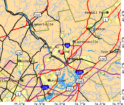
Ewing, New Jersey

Ewing: This was taken on a trip to see my sister who recently relocated to New Jersey.

Ewing: The grandest old oak, on Lower Ferry Road
- add
your
Submit your own pictures of this place and show them to the world
- OSM Map
- General Map
- Google Map
- MSN Map
| Males: 17,782 | |
| Females: 19,127 |
| Median resident age: | 37.0 years |
| New Jersey median age: | 36.7 years |
Zip codes: 08618.
| Ewing: | $96,785 |
| NJ: | $96,346 |
Estimated per capita income in 2022: $44,036 (it was $24,268 in 2000)
Ewing CDP income, earnings, and wages data
Estimated median house or condo value in 2022: $318,348 (it was $132,200 in 2000)
| Ewing: | $318,348 |
| NJ: | $428,900 |
Mean prices in 2022: all housing units: $441,444; detached houses: $514,236; townhouses or other attached units: $262,860; in 2-unit structures: $482,741; in 3-to-4-unit structures: $396,024; in 5-or-more-unit structures: $217,488; mobile homes: $68,149
Detailed information about poverty and poor residents in Ewing, NJ


- 23,96867.1%White alone
- 8,70724.4%Black alone
- 1,5864.4%Hispanic
- 8052.3%Asian alone
- 5391.5%Two or more races
- 450.1%American Indian alone
- 450.1%Other race alone
- 120.03%Native Hawaiian and Other
Pacific Islander alone
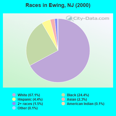
Races in Ewing detailed stats: ancestries, foreign born residents, place of birth
According to our research of New Jersey and other state lists, there were 11 registered sex offenders living in Ewing, New Jersey as of June 12, 2024.
The ratio of all residents to sex offenders in Ewing is 3,355 to 1.
The ratio of registered sex offenders to all residents in this city is lower than the state average.
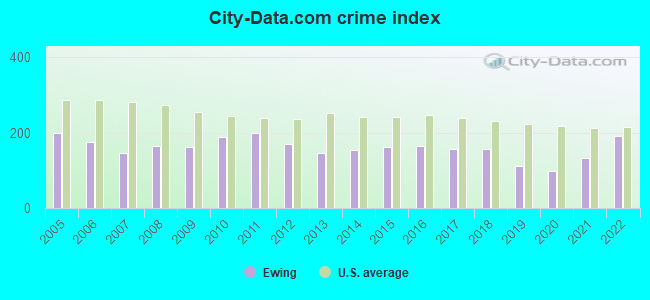
Type |
2009 |
2010 |
2011 |
2012 |
2013 |
2014 |
2015 |
2016 |
2017 |
2018 |
2019 |
2020 |
2021 |
2022 |
|---|---|---|---|---|---|---|---|---|---|---|---|---|---|---|
| Murders (per 100,000) | 0 (0.0) | 2 (5.6) | 2 (5.6) | 2 (5.5) | 1 (2.7) | 0 (0.0) | 2 (5.5) | 2 (5.5) | 1 (2.8) | 0 (0.0) | 0 (0.0) | 1 (2.8) | 3 (7.9) | 2 (5.3) |
| Rapes (per 100,000) | 2 (5.5) | 1 (2.8) | 7 (19.5) | 6 (16.5) | 0 (0.0) | 2 (5.4) | 7 (19.1) | 13 (35.7) | 2 (5.5) | 13 (36.0) | 4 (11.0) | 6 (16.5) | 9 (23.6) | 13 (34.8) |
| Robberies (per 100,000) | 33 (91.4) | 31 (86.6) | 44 (122.5) | 35 (96.2) | 25 (68.6) | 37 (100.6) | 43 (117.3) | 36 (98.8) | 29 (80.2) | 18 (49.8) | 20 (55.0) | 14 (38.5) | 9 (23.6) | 20 (53.5) |
| Assaults (per 100,000) | 73 (202.2) | 87 (243.1) | 32 (89.1) | 33 (90.7) | 44 (120.7) | 29 (78.8) | 25 (68.2) | 21 (57.6) | 44 (121.7) | 38 (105.1) | 36 (99.1) | 28 (77.1) | 50 (131.4) | 41 (109.6) |
| Burglaries (per 100,000) | 142 (393.4) | 182 (508.5) | 257 (715.7) | 218 (599.1) | 165 (452.7) | 195 (530.1) | 135 (368.2) | 121 (332.1) | 150 (414.8) | 113 (312.7) | 76 (209.1) | 49 (134.9) | 59 (155.0) | 55 (147.0) |
| Thefts (per 100,000) | 478 (1,324) | 466 (1,302) | 511 (1,423) | 418 (1,149) | 438 (1,202) | 446 (1,212) | 508 (1,385) | 511 (1,402) | 544 (1,504) | 511 (1,414) | 385 (1,059) | 312 (858.9) | 438 (1,151) | 826 (2,208) |
| Auto thefts (per 100,000) | 44 (121.9) | 62 (173.2) | 46 (128.1) | 44 (120.9) | 72 (197.5) | 78 (212.0) | 30 (81.8) | 28 (76.8) | 49 (135.5) | 61 (168.8) | 46 (126.6) | 43 (118.4) | 40 (105.1) | 74 (197.8) |
| Arson (per 100,000) | 4 (11.1) | 4 (11.2) | 1 (2.8) | 4 (11.0) | 8 (21.9) | 12 (32.6) | 2 (5.5) | 3 (8.2) | 2 (5.5) | 3 (8.3) | 1 (2.8) | 0 (0.0) | 0 (0.0) | 7 (18.7) |
| City-Data.com crime index | 162.6 | 189.6 | 198.6 | 168.7 | 145.8 | 152.9 | 162.7 | 166.2 | 158.4 | 156.7 | 112.3 | 99.0 | 133.4 | 190.9 |
The City-Data.com crime index weighs serious crimes and violent crimes more heavily. Higher means more crime, U.S. average is 246.1. It adjusts for the number of visitors and daily workers commuting into cities.
Crime rate in Ewing detailed stats: murders, rapes, robberies, assaults, burglaries, thefts, arson
Full-time law enforcement employees in 2021, including police officers: 95 (77 officers - 67 male; 10 female).
| Officers per 1,000 residents here: | 2.02 |
| New Jersey average: | 5.53 |
 Recent articles from our blog. Our writers, many of them Ph.D. graduates or candidates, create easy-to-read articles on a wide variety of topics.

 | Trenton - Top place to live and retire (29 replies) |
| Ewing NJ (4 replies) |
| Majority Black middle class suburbs (98 replies) |
| Work in Ewing, live in Hunterdon county? (4 replies) |
| Work in Trenton - safe place to live (17 replies) |
| Ewing (compared to Hamilton West) (16 replies) |
Latest news from Ewing, NJ collected exclusively by city-data.com from local newspapers, TV, and radio stations
Ancestries: Italian (16.7%), Irish (15.4%), German (14.0%), English (10.1%), Polish (8.7%), United States (3.0%).
Current Local Time: EST time zone
Incorporated in 1834
Elevation: 140 feet
Land area: 15.3 square miles.
Population density: 2,407 people per square mile (low).
2,929 residents are foreign born (3.0% Europe, 2.6% Latin America, 1.9% Asia).
| This place: | 8.2% |
| New Jersey: | 17.5% |
| Ewing CDP: | 2.9% ($3,857) |
| New Jersey: | 2.4% ($4,047) |
Nearest city with pop. 50,000+: Trenton, NJ  (3.2 miles , pop. 85,403).
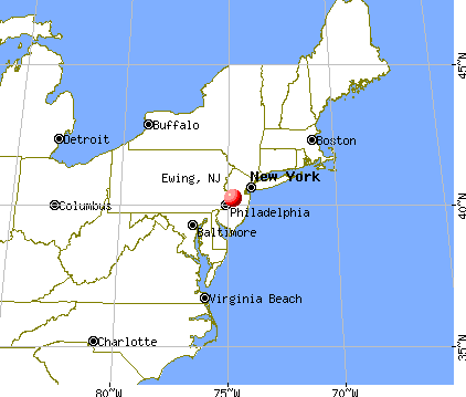
Nearest city with pop. 200,000+: Philadelphia, PA (26.1 miles , pop. 1,517,550).
Nearest cities:
), ), ), ), Latitude: 40.26 N, Longitude: 74.79 W
Daytime population change due to commuting: +3,685 (+10.3%)
Workers who live and work in this place: 4,559 (26.6%)
Area code: 609
Property values in Ewing, NJ

Ewing, New Jersey accommodation & food services, waste management - Economy and Business Data
| Here: | 3.7% |
| New Jersey: | 4.5% |
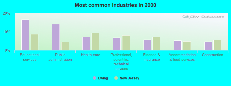
- Educational services (16.6%)
- Public administration (14.1%)
- Health care (7.4%)
- Professional, scientific, technical services (6.8%)
- Finance & insurance (5.8%)
- Accommodation & food services (5.2%)
- Construction (4.6%)
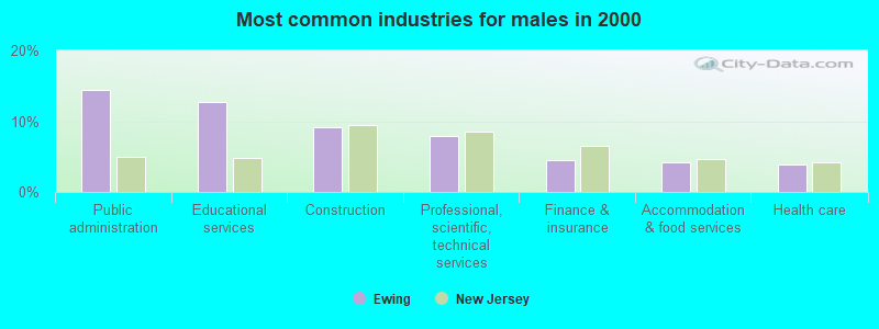
- Public administration (14.4%)
- Educational services (12.7%)
- Construction (9.2%)
- Professional, scientific, technical services (7.9%)
- Finance & insurance (4.4%)
- Accommodation & food services (4.2%)
- Health care (3.9%)
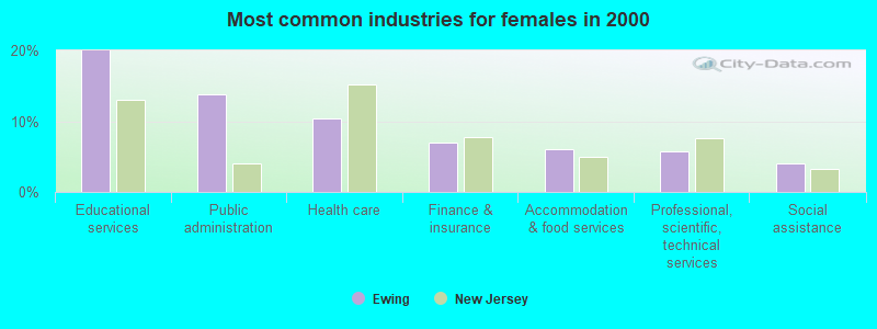
- Educational services (20.0%)
- Public administration (13.9%)
- Health care (10.4%)
- Finance & insurance (6.9%)
- Accommodation & food services (6.1%)
- Professional, scientific, technical services (5.7%)
- Social assistance (4.1%)
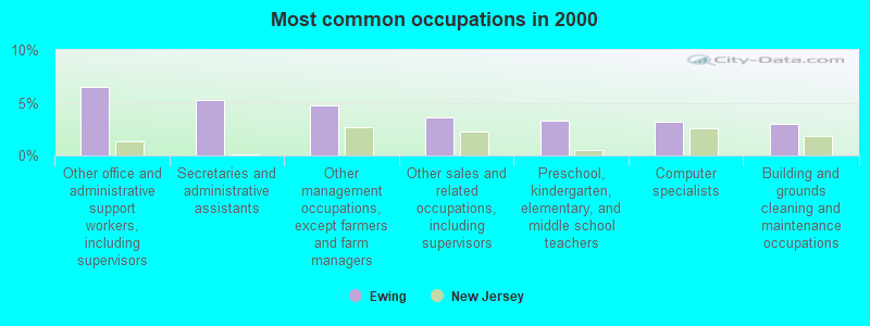
- Other office and administrative support workers, including supervisors (6.5%)
- Secretaries and administrative assistants (5.3%)
- Other management occupations, except farmers and farm managers (4.8%)
- Other sales and related occupations, including supervisors (3.7%)
- Preschool, kindergarten, elementary, and middle school teachers (3.3%)
- Computer specialists (3.2%)
- Building and grounds cleaning and maintenance occupations (3.0%)
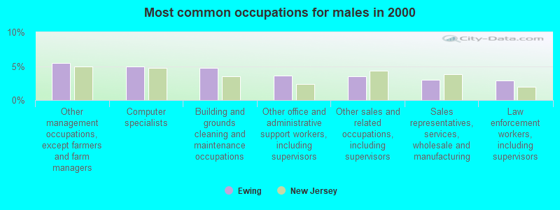
- Other management occupations, except farmers and farm managers (5.5%)
- Computer specialists (5.0%)
- Building and grounds cleaning and maintenance occupations (4.7%)
- Other office and administrative support workers, including supervisors (3.6%)
- Other sales and related occupations, including supervisors (3.5%)
- Sales representatives, services, wholesale and manufacturing (2.9%)
- Law enforcement workers, including supervisors (2.9%)
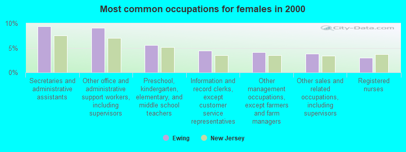
- Secretaries and administrative assistants (9.4%)
- Other office and administrative support workers, including supervisors (9.1%)
- Preschool, kindergarten, elementary, and middle school teachers (5.6%)
- Information and record clerks, except customer service representatives (4.5%)
- Other management occupations, except farmers and farm managers (4.1%)
- Other sales and related occupations, including supervisors (3.8%)
- Registered nurses (2.9%)
Average climate in Ewing, New Jersey
Based on data reported by over 4,000 weather stations


(lower is better)
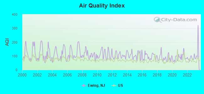
Air Quality Index (AQI) level in 2023 was 125. This is significantly worse than average.
| City: | 125 |
| U.S.: | 73 |
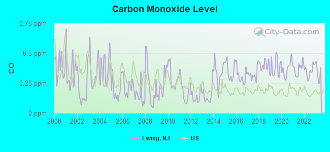
Carbon Monoxide (CO) [ppm] level in 2022 was 0.354. This is significantly worse than average. Closest monitor was 3.0 miles away from the city center.
| City: | 0.354 |
| U.S.: | 0.251 |
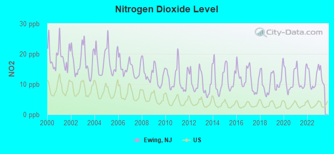
Nitrogen Dioxide (NO2) [ppb] level in 2022 was 11.9. This is significantly worse than average. Closest monitor was 2.9 miles away from the city center.
| City: | 11.9 |
| U.S.: | 5.1 |
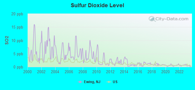
Sulfur Dioxide (SO2) [ppb] level in 2022 was 0.645. This is significantly better than average. Closest monitor was 2.9 miles away from the city center.
| City: | 0.645 |
| U.S.: | 1.515 |
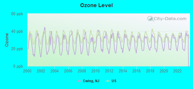
Ozone [ppb] level in 2023 was 31.3. This is about average. Closest monitor was 2.9 miles away from the city center.
| City: | 31.3 |
| U.S.: | 33.3 |
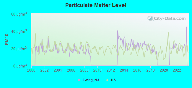
Particulate Matter (PM10) [µg/m3] level in 2022 was 18.9. This is about average. Closest monitor was 2.9 miles away from the city center.
| City: | 18.9 |
| U.S.: | 19.2 |
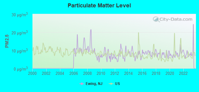
Particulate Matter (PM2.5) [µg/m3] level in 2022 was 7.69. This is about average. Closest monitor was 2.9 miles away from the city center.
| City: | 7.69 |
| U.S.: | 8.11 |
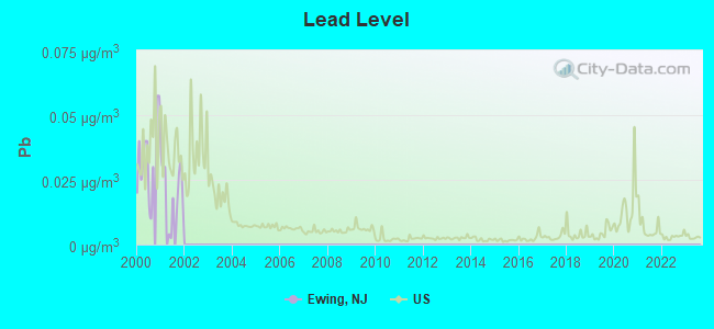
Lead (Pb) [µg/m3] level in 2001 was 0.0173. This is significantly worse than average. Closest monitor was 2.9 miles away from the city center.
| City: | 0.0173 |
| U.S.: | 0.0093 |
Tornado activity:
Ewing-area historical tornado activity is slightly above New Jersey state average. It is 15% smaller than the overall U.S. average.
On 10/18/1990, a category F3 (max. wind speeds 158-206 mph) tornado 15.3 miles away from the Ewing place center injured 8 people and caused between $500,000 and $5,000,000 in damages.
On 8/17/1988, a category F2 (max. wind speeds 113-157 mph) tornado 1.5 miles away from the place center caused between $500,000 and $5,000,000 in damages.
Earthquake activity:
Ewing-area historical earthquake activity is significantly above New Jersey state average. It is 68% smaller than the overall U.S. average.On 8/23/2011 at 17:51:04, a magnitude 5.8 (5.8 MW, Depth: 3.7 mi, Class: Moderate, Intensity: VI - VII) earthquake occurred 234.5 miles away from the city center
On 1/16/1994 at 01:49:16, a magnitude 4.6 (4.6 MB, 4.6 LG, Depth: 3.1 mi, Class: Light, Intensity: IV - V) earthquake occurred 66.0 miles away from the city center
On 10/7/1983 at 10:18:46, a magnitude 5.3 (5.1 MB, 5.3 LG, 5.1 ML) earthquake occurred 256.5 miles away from Ewing center
On 1/16/1994 at 00:42:43, a magnitude 4.2 (4.2 MB, 4.0 LG, Depth: 3.1 mi) earthquake occurred 64.4 miles away from the city center
On 4/20/2002 at 10:50:47, a magnitude 5.3 (5.3 ML, Depth: 3.0 mi) earthquake occurred 299.4 miles away from the city center
On 11/30/2017 at 21:47:31, a magnitude 4.1 (4.1 MW, Depth: 6.1 mi) earthquake occurred 81.1 miles away from the city center
Magnitude types: regional Lg-wave magnitude (LG), body-wave magnitude (MB), local magnitude (ML), moment magnitude (MW)
Natural disasters:
The number of natural disasters in Mercer County (25) is a lot greater than the US average (15).Major Disasters (Presidential) Declared: 16
Emergencies Declared: 9
Causes of natural disasters: Hurricanes: 7, Floods: 5, Storms: 4, Snowstorms: 3, Blizzards: 2, Heavy Rains: 2, Water Shortages: 2, Winter Storms: 2, Tornado: 1, Tropical Depression: 1, Tropical Storm: 1, Wind: 1, Other: 3 (Note: some incidents may be assigned to more than one category).

Main business address for: UNIVERSAL DISPLAY CORP \PA\ (COMPUTER TERMINALS).
Hospitals and medical centers in Ewing:
Amtrak stations near Ewing:
- 4 miles: TRENTON (72 S. CLINTON AVE.) . Services: ticket office, fully wheelchair accessible, enclosed waiting area, public restrooms, public payphones, snack bar, ATM, paid short-term parking, paid long-term parking, car rental agency, taxi stand, public transit connection.
- 10 miles: PRINCETON JUNCTION (WALLACE RD.) . Services: ticket office, fully wheelchair accessible, enclosed waiting area, public restrooms, snack bar, paid short-term parking, paid long-term parking, call for car rental service, taxi stand, public transit connection.
Colleges/Universities in Ewing:
Other colleges/universities with over 2000 students near Ewing:
- Rider University (about 3 miles; Lawrenceville, NJ; Full-time enrollment: 4,960)
- Thomas Edison State College (about 3 miles; Trenton, NJ; FT enrollment: 4,972)
- Mercer County Community College (about 8 miles; West Windsor, NJ; FT enrollment: 5,728)
- Princeton University (about 10 miles; Princeton, NJ; FT enrollment: 6,897)
- Bucks County Community College (about 10 miles; Newtown, PA; FT enrollment: 6,898)
- Strayer University-Pennsylvania (about 13 miles; Trevose, PA; FT enrollment: 2,027)
- Holy Family University (about 18 miles; Philadelphia, PA; FT enrollment: 2,305)
Public high schools in Ewing:
- EWING HIGH SCHOOL (Students: 1,175, Location: 900 PARKWAY AVE, Grades: 9-12)
- CAPITAL ACADEMY (Location: 1440 PARKSIDE AVE, Grades: 9-12)
Private high school in Ewing:
Public elementary/middle schools in Ewing:
- GILMORE J FISHER MIDDLE (Students: 941, Location: 1325 LOWER FERRY ROAD, Grades: 6-8)
- WL ANTHEIL ELEMENTARY SCHOOL (Students: 710, Location: 339 EWINGVILLE ROAD, Grades: PK-5)
- FRANCIS LORE ELEMENTARY SCHOOL (Students: 569, Location: 13 WESTWOOD DRIVE, Grades: PK-5)
- PARKWAY ELEMENTARY SCHOOL (Students: 466, Location: 446 PARKWAY AVENUE, Grades: KG-5)
Private elementary/middle schools in Ewing:
User-submitted facts and corrections:
- Private Preschool: Parkside Montessori, (609) 771 0273, www.parksidemontessori.org
Points of interest:
Notable locations in Ewing: Bloomberg Office Complex (A), Ewing Business Park (B), Mountain View Golf Course (C), MountainView Office Park (D), Princeton Crossroads Corporate Center (E), Trenton Country Club (F), Princeton Crossroads Corporate Center (G), Graphics Drive Industrial Park (H), Sierra Office Park (I), West Trenton Station (J), Ewing Park (K), McCauley House (L), Paul Loser Hall (M), Bliss Hall (N), Kendall Hall (O), Green Hall (P), Brower Student Center (Q), Packer Hall (R), Eickhoff Hall (S), Green Farm House (T). Display/hide their locations on the map
Shopping Center: Suburban Square Shopping Center (1). Display/hide its location on the map
Main business address in Ewing: UNIVERSAL DISPLAY CORP \PA\ (A). Display/hide its location on the map
Church in Ewing: West Trenton Presbyterian Church (A). Display/hide its location on the map
Cemeteries: Saint Hedwigs Cemetery (1), Fountain Lawn Memorial Park Cemetery (2), Ewing Cemetery (3), State Cemetery (4). Display/hide their locations on the map
Reservoirs: Sylva Lake (A), Ceva Lake (B). Display/hide their locations on the map
Streams, rivers, and creeks: Jacobs Creek (A), Gold Run (B). Display/hide their locations on the map
Parks in Ewing include: Moody Park (1), Crestmont Park (2), John S Watson Park (3), Temple Park (4), Ackerman Park (5), Lions Stadium (6), Lions Park (7), Banchoff Park (8), Armstrong Park (9). Display/hide their locations on the map
| This place: | 2.5 people |
| New Jersey: | 2.7 people |
| This place: | 65.4% |
| Whole state: | 70.7% |
| This place: | 4.8% |
| Whole state: | 4.9% |
Likely homosexual households (counted as self-reported same-sex unmarried-partner households)
- Lesbian couples: 0.4% of all households
- Gay men: 0.2% of all households
| This place: | 6.4% |
| Whole state: | 8.5% |
| This place: | 3.3% |
| Whole state: | 4.2% |
People in group quarters in Ewing in 2000:
- 3,486 people in college dormitories (includes college quarters off campus)
- 1,135 people in state prisons
- 227 people in nursing homes
- 65 people in short-term care, detention or diagnostic centers for delinquent children
- 37 people in homes for the mentally retarded
- 32 people in religious group quarters
- 26 people in unknown juvenile institutions
Banks with branches in Ewing (2011 data):
- PNC Bank, National Association: Scotch Road Branch at 40 Scotch Road, branch established on 1996/09/03. Info updated 2012/03/20: Bank assets: $263,309.6 mil, Deposits: $197,343.0 mil, headquarters in Wilmington, DE, positive income, Commercial Lending Specialization, 3085 total offices, Holding Company: Pnc Financial Services Group, Inc., The
- 3rd Fed Bank: Ewing Branch at 2075 Pennington Road, branch established on 1912/01/01. Info updated 2012/02/14: Bank assets: $682.4 mil, Deposits: $555.4 mil, headquarters in Newtown, PA, positive income, Mortgage Lending Specialization, 15 total offices
- JPMorgan Chase Bank, National Association: Ewing Branch at 1852 N Olden Ave, branch established on 2006/06/29. Info updated 2011/11/10: Bank assets: $1,811,678.0 mil, Deposits: $1,190,738.0 mil, headquarters in Columbus, OH, positive income, International Specialization, 5577 total offices, Holding Company: Jpmorgan Chase & Co.
- Wells Fargo Bank, National Association: Ewing Branch at 1488 Pennington Road, branch established on 1950/08/21. Info updated 2011/04/05: Bank assets: $1,161,490.0 mil, Deposits: $905,653.0 mil, headquarters in Sioux Falls, SD, positive income, 6395 total offices, Holding Company: Wells Fargo & Company
- Hopewell Valley Community Bank: Ewing Branch at 180 Scotch Road, branch established on 2006/07/30. Info updated 2006/11/03: Bank assets: $404.4 mil, Deposits: $335.9 mil, headquarters in Pennington, NJ, positive income, Commercial Lending Specialization, 7 total offices
- First Bank: Ewing Branch at 1340 Parkway Avenue, branch established on 2009/03/09. Info updated 2012/02/06: Bank assets: $264.9 mil, Deposits: $234.7 mil, headquarters in Hamilton, NJ, positive income, Commercial Lending Specialization, 3 total offices
For population 15 years and over in Ewing:
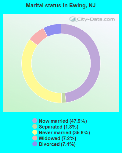
- Never married: 35.6%
- Now married: 47.9%
- Separated: 1.8%
- Widowed: 7.2%
- Divorced: 7.4%
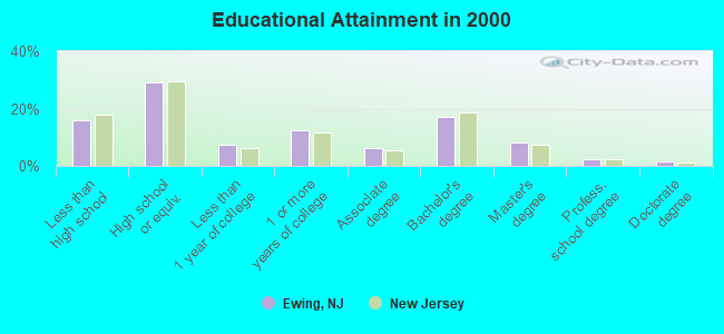
For population 25 years and over in Ewing:
- High school or higher: 84.1%
- Bachelor's degree or higher: 29.1%
- Graduate or professional degree: 12.0%
- Unemployed: 4.6%
- Mean travel time to work (commute): 22.2 minutes
| Here: | 12.0 |
| New Jersey average: | 13.1 |
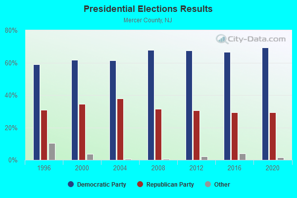
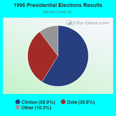
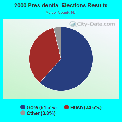
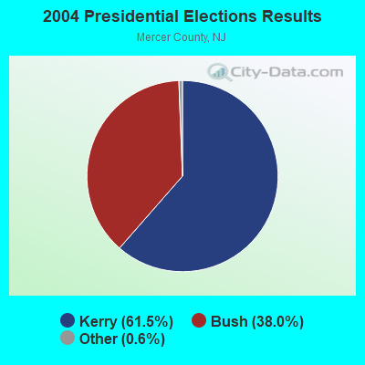
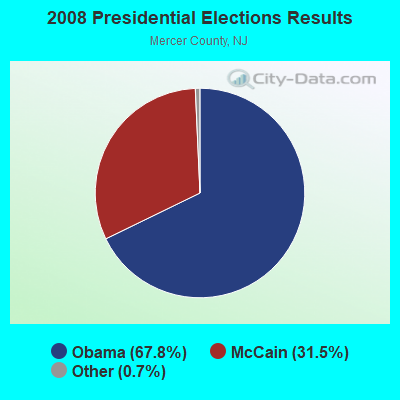
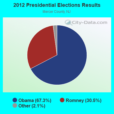
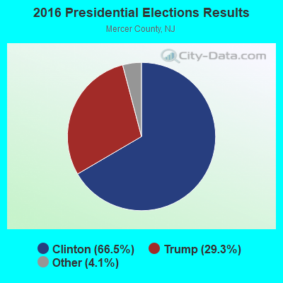
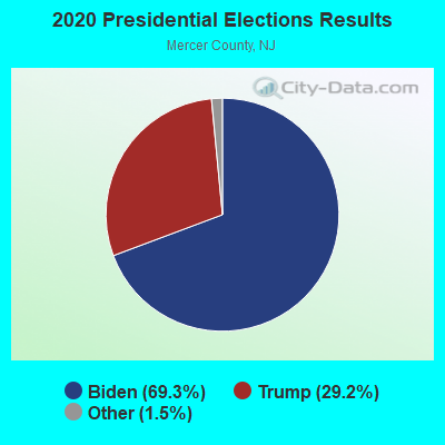
Graphs represent county-level data. Detailed 2008 Election Results
Religion statistics for Ewing, NJ (based on Mercer County data)
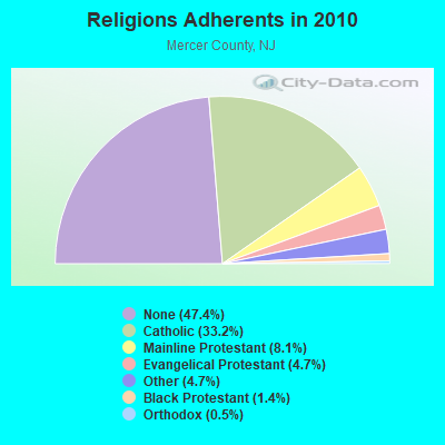
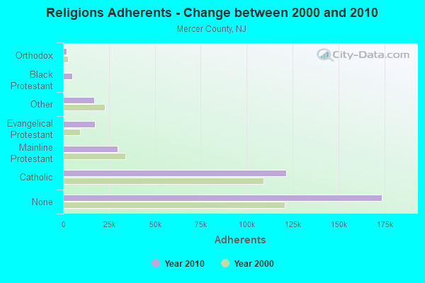
| Religion | Adherents | Congregations |
|---|---|---|
| Catholic | 121,650 | 26 |
| Mainline Protestant | 29,638 | 86 |
| Evangelical Protestant | 17,274 | 91 |
| Other | 17,115 | 38 |
| Black Protestant | 5,146 | 30 |
| Orthodox | 1,960 | 5 |
| None | 173,730 | - |
Food Environment Statistics:
| Mercer County: | 2.94 / 10,000 pop. |
| New Jersey: | 2.90 / 10,000 pop. |
| This county: | 0.05 / 10,000 pop. |
| State: | 0.06 / 10,000 pop. |
| This county: | 1.51 / 10,000 pop. |
| New Jersey: | 1.76 / 10,000 pop. |
| Mercer County: | 0.63 / 10,000 pop. |
| State: | 0.81 / 10,000 pop. |
| This county: | 7.42 / 10,000 pop. |
| New Jersey: | 7.15 / 10,000 pop. |
| Mercer County: | 8.3% |
| New Jersey: | 8.3% |
| Mercer County: | 22.2% |
| State: | 23.3% |
| Mercer County: | 20.1% |
| State: | 18.0% |
6.32% of this county's 2021 resident taxpayers lived in other counties in 2020 ($101,265 average adjusted gross income)
| Here: | 6.32% |
| New Jersey average: | 6.70% |
0.02% of residents moved from foreign countries ($112 average AGI)
Mercer County: 0.02% New Jersey average: 0.01%
Top counties from which taxpayers relocated into this county between 2020 and 2021:
| from Middlesex County, NJ | |
| from Burlington County, NJ | |
| from Bucks County, PA |
7.01% of this county's 2020 resident taxpayers moved to other counties in 2021 ($114,313 average adjusted gross income)
| Here: | 7.01% |
| New Jersey average: | 7.02% |
0.02% of residents moved to foreign countries ($141 average AGI)
Mercer County: 0.02% New Jersey average: 0.02%
Top counties to which taxpayers relocated from this county between 2020 and 2021:
| to Burlington County, NJ | |
| to Middlesex County, NJ | |
| to Bucks County, PA |
| Businesses in Ewing, NJ | ||||
| Name | Count | Name | Count | |
|---|---|---|---|---|
| Advance Auto Parts | 1 | Marriott | 1 | |
| CVS | 1 | Nike | 1 | |
| Curves | 1 | Papa John's Pizza | 1 | |
| Dunkin Donuts | 4 | Popeyes | 1 | |
| FedEx | 4 | Rite Aid | 2 | |
| Foot Locker | 1 | Sprint Nextel | 1 | |
| GNC | 1 | Subway | 2 | |
| GameStop | 1 | True Value | 1 | |
| Goodwill | 2 | U-Haul | 1 | |
| Home Depot | 1 | UPS | 9 | |
| Lane Furniture | 1 | |||
Strongest AM radio stations in Ewing:
- WBUD (1260 AM; 5 kW; TRENTON, NJ; Owner: MILLENNIUM CENTRAL NEW JERSEY LICENSE HOLDCO, LLC)
- WHWH (1350 AM; 10 kW; PRINCETON, NJ; Owner: MULTICULTURAL RADIO BROADCASTING, INC.)
- WWJZ (640 AM; 50 kW; MOUNT HOLLY, NJ; Owner: ABC, INC.)
- WIMG (1300 AM; 3 kW; EWING, NJ; Owner: MORRIS B/C COMPANY OF N. J. INC.)
- WTTM (1680 AM; 10 kW; PRINCETON, NJ; Owner: MULTICULTURAL RADIO BROADCASTING, INC.)
- WPHY (920 AM; 1 kW; TRENTON, NJ; Owner: NASSAU BROADCASTING II, L.L.C.)
- WPHT (1210 AM; 50 kW; PHILADELPHIA, PA; Owner: INFINITY BROADCASTING OPERATIONS, INC.)
- KYW (1060 AM; 50 kW; PHILADELPHIA, PA; Owner: INFINITY BROADCASTING OPERATIONS, INC.)
- WZZD (990 AM; 50 kW; PHILADELPHIA, PA; Owner: PENNSYLVANIA MEDIA ASSOCIATES, INC.)
- WPEN (950 AM; 50 kW; PHILADELPHIA, PA; Owner: GREATER PHILADELPHIA RADIO, INC.)
- WNWR (1540 AM; 50 kW; PHILADELPHIA, PA)
- WVCH (740 AM; 50 kW; CHESTER, PA; Owner: WVCH COMMUNICATIONS, INC.)
- WMCA (570 AM; 50 kW; NEW YORK, NY; Owner: SALEM MEDIA OF NEW YORK, LLC)
Strongest FM radio stations in Ewing:
- WPST (97.5 FM; TRENTON, NJ; Owner: NASSAU BROADCASTING II, L.L.C.)
- WKXW-FM (101.5 FM; TRENTON, NJ; Owner: MILLENNIUM CENTRAL NEW JERSEY LICENSE HOLDCO, LLC)
- WTHK (94.5 FM; TRENTON, NJ; Owner: NASSAU BROADCASTING II, L.L.C.)
- WNJT-FM (88.1 FM; TRENTON, NJ; Owner: NEW JERSEY PUBLIC BRD/CST AUTHORITY)
- WPRB (103.3 FM; PRINCETON, NJ; Owner: PRINCETON BROADCASTING SERVICE, INC.)
- WTSR (91.3 FM; TRENTON, NJ; Owner: THE COLLEGE OF NJ RADIO SYSTEM)
- W220AG (91.9 FM; LAWRENCEVILLE, ETC., NJ; Owner: BUX-MONT EDUCATIONAL RADIO ASSOC.)
- WWFM (89.1 FM; TRENTON, NJ; Owner: MERCER COUNTY COMMUNITY COLLEGE)
- WMGK (102.9 FM; PHILADELPHIA, PA; Owner: GREATER PHILADELPHIA RADIO, INC.)
- WMWX (95.7 FM; PHILADELPHIA, PA; Owner: GREATER PHILADELPHIA RADIO, INC.)
- WOGL (98.1 FM; PHILADELPHIA, PA; Owner: INFINITY BROADCASTING OPERATIONS, INC.)
- WBEB (101.1 FM; PHILADELPHIA, PA; Owner: WEAZ-FM RADIO, INC.)
- WRTI (90.1 FM; PHILADELPHIA, PA; Owner: TEMPLE UNIV. OF THE COMMONWEALTH, ET)
- WSNI-FM (104.5 FM; PHILADELPHIA, PA; Owner: AMFM RADIO LICENSES, L.L.C.)
- WPHI-FM (103.9 FM; JENKINTOWN, PA; Owner: RADIO ONE LICENSES, LLC)
- WYSP (94.1 FM; PHILADELPHIA, PA; Owner: INFINITY BROADCASTING OPERATIONS, INC.)
- WHYY-FM (90.9 FM; PHILADELPHIA, PA; Owner: WHYY, INC.)
- WXPN (88.5 FM; PHILADELPHIA, PA; Owner: TRUSTEES OF THE UNIVERSITY OF PENNA.)
- WJJZ (106.1 FM; PHILADELPHIA, PA; Owner: AMFM RADIO LICENSES, L.L.C.)
- WXTU (92.5 FM; PHILADELPHIA, PA; Owner: WXTU LICENSE LIMITED PARTNERSHIP)
TV broadcast stations around Ewing:
- WNJT (Channel 52; TRENTON, NJ; Owner: NEW JERSEY PUBLIC BROADCASTING AUTHORITY)
- WNJN (Channel 50; MONTCLAIR, NJ; Owner: NEW JERSEY PUBLIC B/CNG AUTHORITY)
- W25AW (Channel 25; TRENTON, NJ; Owner: WZBN TV, INC.)
- KYW-TV (Channel 3; PHILADELPHIA, PA; Owner: CBS BROADCASTING INC.)
- WPHL-TV (Channel 17; PHILADELPHIA, PA; Owner: TRIBUNE TELEVISION COMPANY)
- WPPX (Channel 61; WILMINGTON, DE; Owner: PAXSON PHILADELPHIA LICENSE, INC.)
- WPVI-TV (Channel 6; PHILADELPHIA, PA; Owner: ABC, INC.)
- WPSG (Channel 57; PHILADELPHIA, PA; Owner: VIACOM STATIONS GROUP OF PHILADELPHIA INC.)
- WCAU (Channel 10; PHILADELPHIA, PA; Owner: NBC SUBSIDIARY (WCAU-TV), L.P.)
- WGTW (Channel 48; BURLINGTON, NJ; Owner: BRUNSON COMMUNICATIONS, INC.)
- WYBE (Channel 35; PHILADELPHIA, PA; Owner: INDEPENDENCE PUBLIC MEDIA OF PHILADELPHIA, INC.)
- WELL-LP (Channel 8; WILLOW GROVE, ETC., PA; Owner: WORD OF GOD FELLOWSHIP, INC.)
- WWJT-LP (Channel 7; PHILADELPHIA, PA; Owner: PHILADELPHIA TELEVISION NETWORK, INC)
- WHYY-TV (Channel 12; WILMINGTON, DE; Owner: WHYY, INC.)
- WNYW (Channel 5; NEW YORK, NY; Owner: FOX TELEVISION STATIONS, INC.)
- WTXF-TV (Channel 29; PHILADELPHIA, PA; Owner: FOX TV STATIONS OF PHILADELPHIA)
- WCBS-TV (Channel 2; NEW YORK, NY; Owner: CBS BROADCASTING INC.)
- WUVP (Channel 65; VINELAND, NJ; Owner: UNIVISION PHILADELPHIA LLC)
- WABC-TV (Channel 7; NEW YORK, NY; Owner: AMERICAN BROADCASTING COMPANIES, INC)
- WPIX (Channel 11; NEW YORK, NY; Owner: WPIX, INC.)
- WWOR-TV (Channel 9; SECAUCUS, NJ; Owner: FOX TELEVISION STATIONS, INC.)
- WPXN-TV (Channel 31; NEW YORK, NY; Owner: PAXSON COMMUNICATIONS LICENSE COMPANY, LLC)
- WNBC (Channel 4; NEW YORK, NY; Owner: NATIONAL BROADCASTING COMPANY, INC.)
- WNET (Channel 13; NEWARK, NJ; Owner: EDUCATIONAL BROADCASTING CORPORATION)
- WXTV (Channel 41; PATERSON, NJ; Owner: WXTV LICENSE PARTNERSHIP, G.P.)
- National Bridge Inventory (NBI) Statistics
- 31Number of bridges
- 207ft / 63.3mTotal length
- $8,020,000Total costs
- 518,242Total average daily traffic
- 34,568Total average daily truck traffic
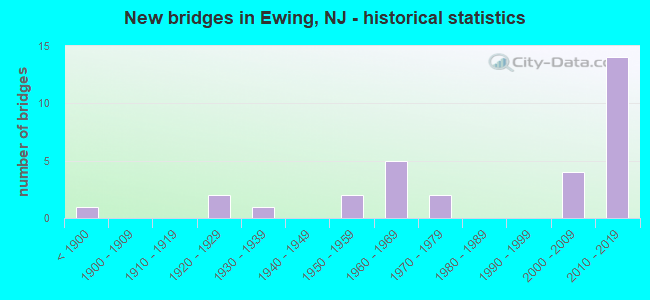
- New bridges - historical statistics
- 1Before 1900
- 21920-1929
- 11930-1939
- 21950-1959
- 51960-1969
- 21970-1979
- 42000-2009
- 142010-2019
FCC Registered Private Land Mobile Towers: 1 (See the full list of FCC Registered Private Land Mobile Towers in Ewing, NJ)
FCC Registered Broadcast Land Mobile Towers: 9 (See the full list of FCC Registered Broadcast Land Mobile Towers)
FCC Registered Microwave Towers: 12 (See the full list of FCC Registered Microwave Towers in this town)
FCC Registered Amateur Radio Licenses: 58 (See the full list of FCC Registered Amateur Radio Licenses in Ewing)
FAA Registered Aircraft: 17 (See the full list of FAA Registered Aircraft in Ewing)
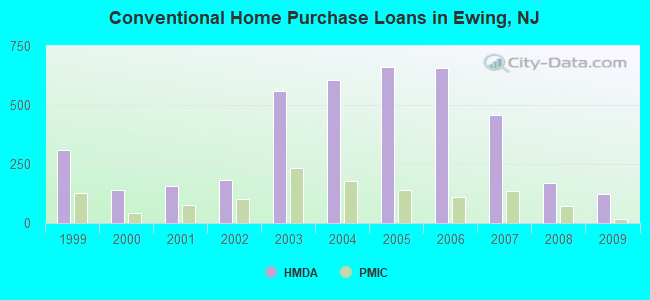
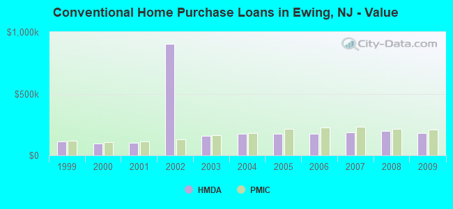
| Home Mortgage Disclosure Act Aggregated Statistics For Year 2009 (Based on 8 full tracts) | ||||||||||
| A) FHA, FSA/RHS & VA Home Purchase Loans | B) Conventional Home Purchase Loans | C) Refinancings | D) Home Improvement Loans | F) Non-occupant Loans on < 5 Family Dwellings (A B C & D) | ||||||
|---|---|---|---|---|---|---|---|---|---|---|
| Number | Average Value | Number | Average Value | Number | Average Value | Number | Average Value | Number | Average Value | |
| LOANS ORIGINATED | 174 | $203,000 | 121 | $183,240 | 650 | $191,869 | 54 | $61,019 | 30 | $161,667 |
| APPLICATIONS APPROVED, NOT ACCEPTED | 8 | $231,500 | 8 | $204,000 | 60 | $198,150 | 16 | $25,062 | 3 | $121,000 |
| APPLICATIONS DENIED | 18 | $204,944 | 19 | $191,421 | 366 | $200,973 | 45 | $43,400 | 28 | $155,321 |
| APPLICATIONS WITHDRAWN | 14 | $164,071 | 16 | $191,875 | 230 | $206,787 | 13 | $87,615 | 9 | $150,667 |
| FILES CLOSED FOR INCOMPLETENESS | 4 | $199,250 | 7 | $215,714 | 48 | $183,792 | 3 | $174,333 | 1 | $169,000 |
Detailed HMDA statistics for the following Tracts: 0034.00 , 0035.00, 0036.01, 0036.02, 0037.03, 0037.04, 0037.05, 0037.06
| Private Mortgage Insurance Companies Aggregated Statistics For Year 2009 (Based on 8 full tracts) | ||||||
| A) Conventional Home Purchase Loans | B) Refinancings | C) Non-occupant Loans on < 5 Family Dwellings (A & B) | ||||
|---|---|---|---|---|---|---|
| Number | Average Value | Number | Average Value | Number | Average Value | |
| LOANS ORIGINATED | 15 | $209,933 | 11 | $220,545 | 0 | $0 |
| APPLICATIONS APPROVED, NOT ACCEPTED | 3 | $167,333 | 7 | $280,429 | 0 | $0 |
| APPLICATIONS DENIED | 0 | $0 | 4 | $249,500 | 0 | $0 |
| APPLICATIONS WITHDRAWN | 3 | $210,333 | 0 | $0 | 1 | $97,000 |
| FILES CLOSED FOR INCOMPLETENESS | 1 | $417,000 | 0 | $0 | 0 | $0 |
Detailed PMIC statistics for the following Tracts: 0034.00 , 0035.00, 0036.01, 0036.02, 0037.03, 0037.04, 0037.05, 0037.06
2004 - 2018 National Fire Incident Reporting System (NFIRS) incidents
- Fire incident types reported to NFIRS in Ewing, NJ
- 1,91272.2%Structure Fires
- 47317.9%Outside Fires
- 2248.5%Mobile Property/Vehicle Fires
- 401.5%Other
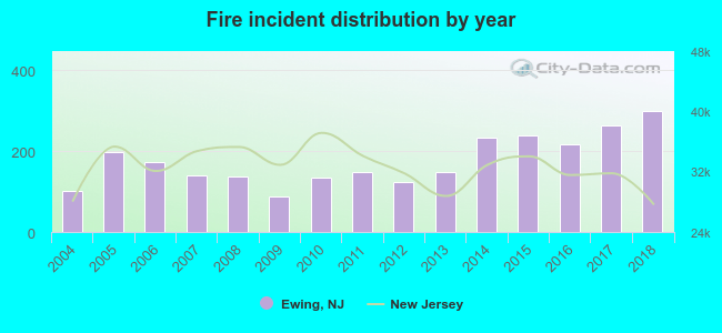 According to the data from the years 2004 - 2018 the average number of fires per year is 176. The highest number of reported fire incidents - 298 took place in 2018, and the least - 88 in 2009. The data has an increasing trend.
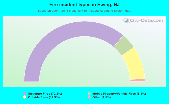 When looking into fire subcategories, the most reports belonged to: Structure Fires (72.2%), and Outside Fires (17.9%).
Fire-safe hotels and motels in Ewing, New Jersey:
- Element Ewing Hopewell, 1000 Sam Weinroth Road E, Ewing, New Jersey 08628 , Phone: (609) 671-0050, Fax: (609) 671-0151
- Springhill Suites By Marriott Ewing, NJ, 800 Charles Ewing Blvd, Ewing, New Jersey 08628 , Phone: (609) 530-0900, Fax: (609) 530-0905
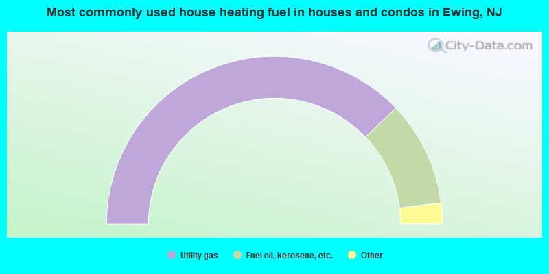
- 75.7%Utility gas
- 20.3%Fuel oil, kerosene, etc.
- 3.1%Electricity
- 0.5%Bottled, tank, or LP gas
- 0.2%Other fuel
- 0.2%Wood
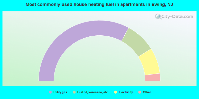
- 66.0%Utility gas
- 16.3%Fuel oil, kerosene, etc.
- 13.8%Electricity
- 2.2%Bottled, tank, or LP gas
- 1.1%No fuel used
- 0.7%Other fuel
Ewing compared to New Jersey state average:
- Unemployed percentage significantly below state average.
- Black race population percentage above state average.
- Hispanic race population percentage significantly below state average.
- Median age below state average.
- Foreign-born population percentage significantly below state average.
- Renting percentage significantly below state average.
- Length of stay since moving in significantly above state average.
- Number of rooms per house significantly below state average.
- House age significantly below state average.
- Institutionalized population percentage significantly above state average.
- Number of college students above state average.
Ewing on our top lists:
- #21 on the list of "Top 101 cities with largest percentage of males in occupations: legal support workers (population 5,000+)"
- #46 on the list of "Top 101 cities with largest percentage of males in occupations: special education teachers (population 5,000+)"
- #54 on the list of "Top 101 cities with largest percentage of males in occupations: secretaries and administrative assistants (population 5,000+)"
- #60 on the list of "Top 101 cities with largest percentage of males in occupations: other office and administrative support workers including supervisors (population 5,000+)"
- #63 on the list of "Top 101 cities with largest percentage of females in occupations: other protective service workers including supervisors (population 5,000+)"
- #65 on the list of "Top 101 cities with largest percentage of males in occupations: other protective service workers including supervisors (population 5,000+)"
- #95 on the list of "Top 101 cities with largest percentage of males in industries: broadcasting, internet publishing, and telecommunications services (population 5,000+)"
- #95 on the list of "Top 101 cities with largest percentage of females in industries: broadcasting, internet publishing, and telecommunications services (population 5,000+)"
- #95 on the list of "Top 101 cities with largest percentage of females in industries: farm supplies merchant wholesalers (population 5,000+)"
- #95 on the list of "Top 101 cities with largest percentage of males in industries: wholesale electronic markets and agents and brokers (population 5,000+)"
- #95 on the list of "Top 101 cities with largest percentage of females in industries: wholesale electronic markets and agents and brokers (population 5,000+)"
- #14 on the list of "Top 101 counties with the largest increase in the number of infant deaths per 1000 residents 2000-2006 to 2007-2013 (pop. 50,000+)"
- #22 on the list of "Top 101 counties with the lowest percentage of residents that keep firearms around their homes"
- #34 on the list of "Top 101 counties with the highest average weight of females"
- #39 on the list of "Top 101 counties with the highest number of infant deaths per 1000 residents 2007-2013 (pop. 50,000+)"
- #40 on the list of "Top 101 counties with the largest number of people moving out compared to moving in (pop. 50,000+)"

|
|
Total of 438 patent applications in 2008-2024.