Weston, Vermont
Submit your own pictures of this town and show them to the world
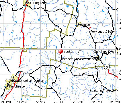
- OSM Map
- General Map
- Google Map
- MSN Map
Population change since 2000: -10.2%
 |
| Males: 295 | |
| Females: 271 |
| Median resident age: | 55.7 years |
| Vermont median age: | 45.8 years |
Zip codes: 05161.
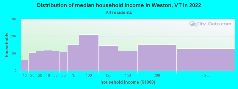
| Weston: | $76,478 |
| VT: | $73,991 |
Estimated per capita income in 2022: $71,513 (it was $36,546 in 2000)
Weston town income, earnings, and wages data
Estimated median house or condo value in 2022: $424,070 (it was $170,200 in 2000)
| Weston: | $424,070 |
| VT: | $304,700 |
Mean prices in 2022: all housing units: $358,264; detached houses: $381,996; townhouses or other attached units: $340,107; in 2-unit structures: $283,645; in 3-to-4-unit structures: $498,076; in 5-or-more-unit structures: $190,965; mobile homes: $75,013
Detailed information about poverty and poor residents in Weston, VT


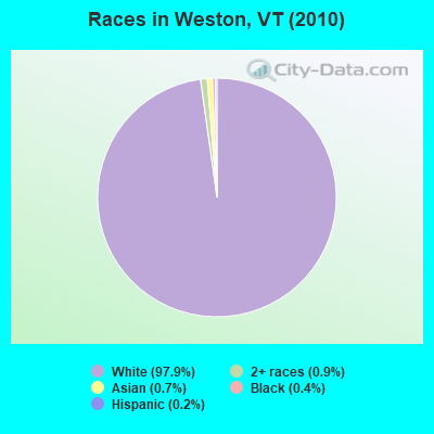
- 55497.9%White alone
- 50.9%Two or more races
- 40.7%Asian alone
- 20.4%Black alone
- 10.2%Hispanic
Races in Weston detailed stats: ancestries, foreign born residents, place of birth
 Recent articles from our blog. Our writers, many of them Ph.D. graduates or candidates, create easy-to-read articles on a wide variety of topics.

 | Another 'Where Should I Live in Vermont' Post (11 replies) |
| Weston information (6 replies) |
| Visit Green Mountain National Forest: Questions (7 replies) |
| Vermont will pay you $10,000 to move there. (47 replies) |
| Vermont versus New Hampshire living and life styles ... (2 replies) |
| Windsor County (Andover/Ludlow area) (2 replies) |
Latest news from Weston, VT collected exclusively by city-data.com from local newspapers, TV, and radio stations
Ancestries: English (21.3%), German (14.9%), Irish (13.8%), United States (11.6%), French (4.1%), Scottish (4.1%).
Current Local Time: EST time zone
Elevation: 1295 feet
Land area: 35.1 square miles.
Population density: 16 people per square mile (very low).
17 residents are foreign born (1.3% Asia, 0.8% Latin America, 0.3% Europe, 0.3% North America).
| This town: | 2.7% |
| Vermont: | 3.8% |
| Weston town: | 1.3% ($2,145) |
| Vermont: | 2.0% ($2,196) |
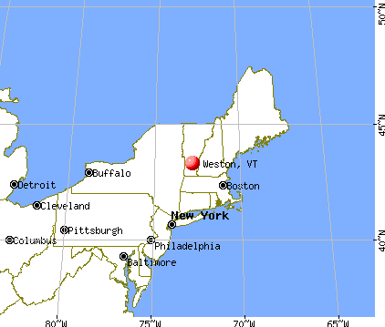
Nearest city with pop. 50,000+: Albany, NY  (67.0 miles , pop. 95,658).
Nearest city with pop. 200,000+: Boston, MA (109.9 miles , pop. 589,141).
Nearest city with pop. 1,000,000+: Bronx, NY (178.8 miles , pop. 1,332,650).
Nearest cities:
), ), ), )Latitude: 43.30 N, Longitude: 72.79 W
Area code commonly used in this area: 802
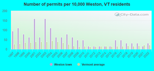
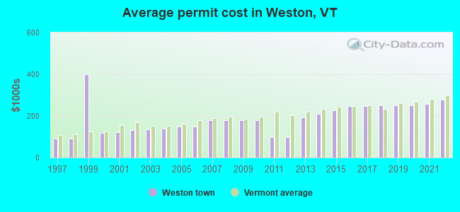
Single-family new house construction building permits:
- 2022: 2 buildings, average cost: $279,200
- 2021: 1 building, cost: $259,200
- 2020: 2 buildings, average cost: $249,800
- 2019: 2 buildings, average cost: $249,800
- 2018: 2 buildings, average cost: $249,800
- 2017: 3 buildings, average cost: $246,000
- 2016: 3 buildings, average cost: $246,000
- 2015: 1 building, cost: $226,800
- 2014: 1 building, cost: $211,200
- 2013: 1 building, cost: $193,300
- 2012: 1 building, cost: $100,000
- 2011: 1 building, cost: $100,000
- 2010: 3 buildings, average cost: $181,200
- 2009: 3 buildings, average cost: $181,200
- 2008: 4 buildings, average cost: $181,200
- 2007: 5 buildings, average cost: $181,200
- 2006: 4 buildings, average cost: $150,200
- 2005: 4 buildings, average cost: $150,200
- 2004: 7 buildings, average cost: $138,800
- 2003: 10 buildings, average cost: $134,000
- 2002: 4 buildings, average cost: $130,700
- 2001: 10 buildings, average cost: $121,400
- 2000: 4 buildings, average cost: $118,000
- 1999: 5 buildings, average cost: $400,000
- 1998: 7 buildings, average cost: $91,700
- 1997: 6 buildings, average cost: $91,700
| Here: | 1.8% |
| Vermont: | 2.0% |
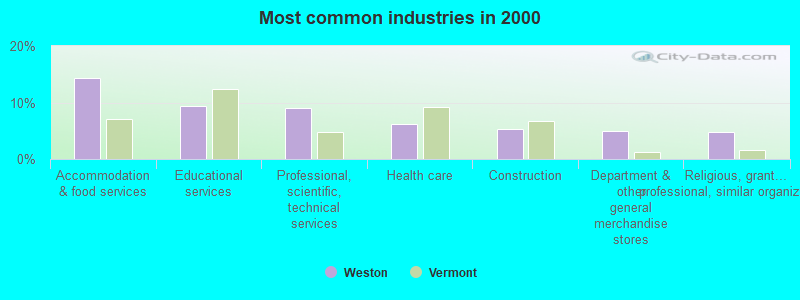
- Accommodation & food services (14.4%)
- Educational services (9.4%)
- Professional, scientific, technical services (9.1%)
- Health care (6.3%)
- Construction (5.3%)
- Department & other general merchandise stores (5.0%)
- Religious, grantmaking, civic, professional, similar organizations (4.7%)
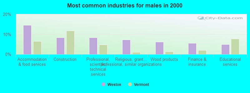
- Accommodation & food services (14.5%)
- Construction (8.4%)
- Professional, scientific, technical services (8.4%)
- Religious, grantmaking, civic, professional, similar organizations (7.3%)
- Wood products (6.1%)
- Finance & insurance (5.6%)
- Educational services (5.0%)
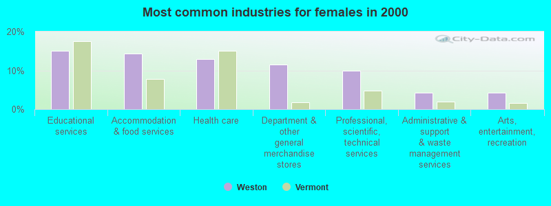
- Educational services (15.0%)
- Accommodation & food services (14.3%)
- Health care (12.9%)
- Department & other general merchandise stores (11.4%)
- Professional, scientific, technical services (10.0%)
- Administrative & support & waste management services (4.3%)
- Arts, entertainment, recreation (4.3%)
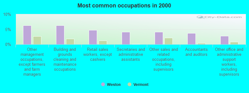
- Other management occupations, except farmers and farm managers (6.3%)
- Building and grounds cleaning and maintenance occupations (6.3%)
- Retail sales workers, except cashiers (4.7%)
- Secretaries and administrative assistants (4.1%)
- Other sales and related occupations, including supervisors (4.1%)
- Accountants and auditors (3.8%)
- Other office and administrative support workers, including supervisors (2.8%)
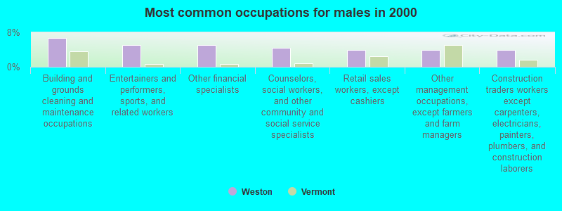
- Building and grounds cleaning and maintenance occupations (6.7%)
- Entertainers and performers, sports, and related workers (5.0%)
- Other financial specialists (5.0%)
- Counselors, social workers, and other community and social service specialists (4.5%)
- Retail sales workers, except cashiers (3.9%)
- Other management occupations, except farmers and farm managers (3.9%)
- Construction traders workers except carpenters, electricians, painters, plumbers, and construction laborers (3.9%)
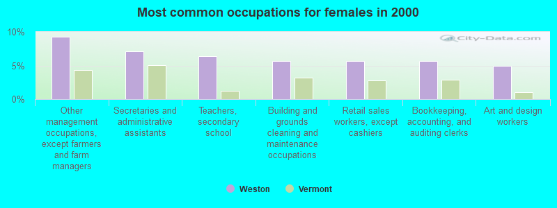
- Other management occupations, except farmers and farm managers (9.3%)
- Secretaries and administrative assistants (7.1%)
- Teachers, secondary school (6.4%)
- Building and grounds cleaning and maintenance occupations (5.7%)
- Retail sales workers, except cashiers (5.7%)
- Bookkeeping, accounting, and auditing clerks (5.7%)
- Art and design workers (5.0%)
Average climate in Weston, Vermont
Based on data reported by over 4,000 weather stations


(lower is better)
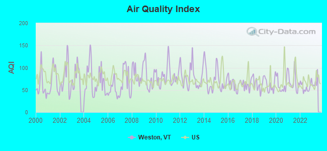
Air Quality Index (AQI) level in 2022 was 56.9. This is better than average.
| City: | 56.9 |
| U.S.: | 72.6 |
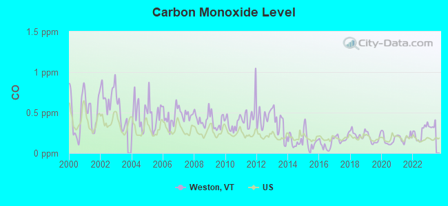
Carbon Monoxide (CO) [ppm] level in 2022 was 0.251. This is about average. Closest monitor was 23.1 miles away from the city center.
| City: | 0.251 |
| U.S.: | 0.251 |
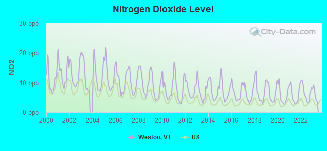
Nitrogen Dioxide (NO2) [ppb] level in 2022 was 6.51. This is worse than average. Closest monitor was 23.1 miles away from the city center.
| City: | 6.51 |
| U.S.: | 5.11 |
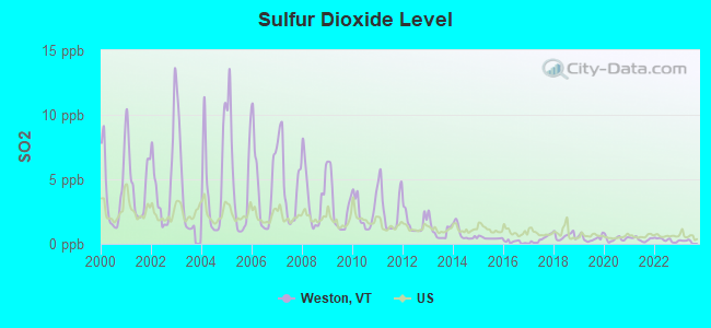
Sulfur Dioxide (SO2) [ppb] level in 2022 was 0.299. This is significantly better than average. Closest monitor was 16.0 miles away from the city center.
| City: | 0.299 |
| U.S.: | 1.515 |
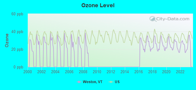
Ozone [ppb] level in 2022 was 23.5. This is significantly better than average. Closest monitor was 23.1 miles away from the city center.
| City: | 23.5 |
| U.S.: | 33.3 |
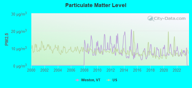
Particulate Matter (PM2.5) [µg/m3] level in 2022 was 7.23. This is about average. Closest monitor was 23.1 miles away from the city center.
| City: | 7.23 |
| U.S.: | 8.11 |
Tornado activity:
Weston-area historical tornado activity is above Vermont state average. It is 53% smaller than the overall U.S. average.
On 8/20/1968, a category F3 (max. wind speeds 158-206 mph) tornado 14.1 miles away from the Weston town center injured one person and caused between $5000 and $50,000 in damages.
On 5/31/1998, a category F3 tornado 32.4 miles away from the town center injured 68 people and caused $71 million in damages.
Earthquake activity:
Weston-area historical earthquake activity is significantly above Vermont state average. It is 69% smaller than the overall U.S. average.On 10/7/1983 at 10:18:46, a magnitude 5.3 (5.1 MB, 5.3 LG, 5.1 ML, Class: Moderate, Intensity: VI - VII) earthquake occurred 89.7 miles away from Weston center
On 4/20/2002 at 10:50:47, a magnitude 5.3 (5.3 ML, Depth: 3.0 mi) earthquake occurred 95.0 miles away from Weston center
On 4/20/2002 at 10:50:47, a magnitude 5.2 (5.2 MB, 4.2 MS, 5.2 MW, 5.0 MW) earthquake occurred 94.0 miles away from Weston center
On 1/19/1982 at 00:14:42, a magnitude 4.7 (4.5 MB, 4.7 MD, 4.5 LG, Class: Light, Intensity: IV - V) earthquake occurred 61.4 miles away from Weston center
On 10/16/2012 at 23:12:25, a magnitude 4.7 (4.7 ML, Depth: 10.0 mi) earthquake occurred 109.1 miles away from Weston center
On 6/17/1991 at 08:53:16, a magnitude 4.1 (4.0 MB, 4.0 LG, Depth: 3.1 mi) earthquake occurred 106.2 miles away from Weston center
Magnitude types: regional Lg-wave magnitude (LG), body-wave magnitude (MB), duration magnitude (MD), local magnitude (ML), surface-wave magnitude (MS), moment magnitude (MW)
Natural disasters:
The number of natural disasters in Windsor County (20) is greater than the US average (15).Major Disasters (Presidential) Declared: 16
Emergencies Declared: 2
Causes of natural disasters: Floods: 14, Storms: 13, Tropical Storms: 2, Heavy Rain: 1, Hurricane: 1, Ice Storm: 1, Landslide: 1, Snowstorm: 1, Wind: 1, Winter Storm: 1 (Note: some incidents may be assigned to more than one category).
Colleges/universities with over 2000 students nearest to Weston:
- Castleton State College (about 29 miles; Castleton, VT; Full-time enrollment: 2,079)
- Keene State College (about 37 miles; Keene, NH; FT enrollment: 5,098)
- Dartmouth College (about 38 miles; Hanover, NH; FT enrollment: 6,030)
- Adirondack Community College (about 44 miles; Queensbury, NY; FT enrollment: 2,826)
- Williams College (about 46 miles; Williamstown, MA; FT enrollment: 2,141)
- Franklin Pierce University (about 52 miles; Rindge, NH; FT enrollment: 2,139)
- Skidmore College (about 53 miles; Saratoga Springs, NY; FT enrollment: 2,753)
Points of interest:
Notable locations in Weston: Wantastiquet Trout Club (A), Weston Bowl Mill (B), Greendale Camp and Picnic Grounds (C), Wilder Memorial Library (D), Weston Playhouse (E), Weston Volunteer Fire Department (F), Farrar-Mansur Museum (G). Display/hide their locations on the map
Churches in Weston include: Weston Community Church (A), Zion Chapel (B), Weston Priory (C), Old Parish Church (D). Display/hide their locations on the map
Cemeteries: Maple Grove Cemetery (1), Island Cemetery (2), Forefathers Cemetery (3). Display/hide their locations on the map
Lakes and reservoirs: Peabody Pond (A), Moses Pond (B), Wantastiquet Lake (C). Display/hide their locations on the map
Streams, rivers, and creeks: Jenny Coolidge Brook (A), Greendale Brook (B). Display/hide their locations on the map
Parks in Weston include: Weston Village Historic District (1), Farrar Park (2). Display/hide their locations on the map
Hotel: Judge Wilder Inn (25 Lawrence Hill Rd) (1). Display/hide its approximate location on the map
Birthplace of: Aaron H. Cragin - Politician, Hiram Sanford Stevens - Politician, Joseph A. Gilmore - Politician, Sam Lloyd - Actor.
Drinking water stations with addresses in Weston and their reported violations in the past:
LITTLE SCHOOL (Population served: 89, Groundwater):Past monitoring violations:BRYANT HOUSE RESTAURANT (Address: 657 MAIN ST , Population served: 75, Groundwater):
- Follow-up Or Routine LCR Tap M/R - In JAN-01-1997, Contaminant: Lead and Copper Rule. Follow-up actions: St Violation/Reminder Notice (JUL-01-1997), St Compliance achieved (MAR-17-2011)
Past health violations:INN AT WESTON (Population served: 68, Groundwater):Past monitoring violations:
- MCL, Monthly (TCR) - In JUN-2008, Contaminant: Coliform. Follow-up actions: St Boil Water Order (JUN-18-2008), St Formal NOV issued (JUN-18-2008), St Tech Assistance Visit (JUN-18-2008), St Public Notif requested (JUN-18-2008), St Compliance achieved (SEP-25-2009)
- 4 routine major monitoring violations
- 50 regular monitoring violations
Past health violations:WESTON PLAYHOUSE (Population served: 60, Groundwater):Past monitoring violations:
- MCL, Monthly (TCR) - In OCT-2012, Contaminant: Coliform. Follow-up actions: St Tech Assistance Visit (OCT-11-2012), St Formal NOV issued (OCT-11-2012), St Public Notif requested (OCT-11-2012), St Boil Water Order (OCT-11-2012), St Compliance achieved (NOV-26-2012)
- MCL, Monthly (TCR) - In JUL-2011, Contaminant: Coliform. Follow-up actions: St Tech Assistance Visit (JUL-20-2011), St Formal NOV issued (JUL-20-2011), St Public Notif requested (JUL-20-2011), St Boil Water Order (JUL-20-2011), St Compliance achieved (JAN-26-2012)
- MCL, Monthly (TCR) - In JUN-2008, Contaminant: Coliform. Follow-up actions: St Boil Water Order (JUL-11-2008), St Tech Assistance Visit (JUL-11-2008), St Public Notif requested (JUL-11-2008), St Formal NOV issued (JUL-11-2008)
- Monitoring, Repeat Major (TCR) - Between APR-2011 and JUN-2011, Contaminant: Coliform (TCR). Follow-up actions: St Public Notif requested (JUL-29-2011), St Formal NOV issued (JUL-29-2011), St Compliance achieved (JAN-26-2012)
- Monitoring, Repeat Major (TCR) - Between OCT-2010 and DEC-2010, Contaminant: Coliform (TCR). Follow-up actions: St Public Notif requested (JAN-25-2011), St Formal NOV issued (JAN-25-2011), St Compliance achieved (JAN-26-2012)
- 5 routine major monitoring violations
- 2 regular monitoring violations
Past monitoring violations:VERMONT COUNTRY STORE WESTON (Address: 657 MAIN ST , Population served: 49, Groundwater):
- 3 routine major monitoring violations
- One minor monitoring violation
- One regular monitoring violation
Past monitoring violations:
- 3 routine major monitoring violations
| This town: | 2.1 people |
| Vermont: | 2.3 people |
| This town: | 59.9% |
| Whole state: | 62.5% |
| This town: | 6.9% |
| Whole state: | 9.2% |
Likely homosexual households (counted as self-reported same-sex unmarried-partner households)
- Lesbian couples: 0.8% of all households
- Gay men: 1.5% of all households
| This town: | 8.1% |
| Whole state: | 9.4% |
| This town: | 4.8% |
| Whole state: | 3.6% |
19 people in religious group quarters in 2000
For population 15 years and over in Weston:

- Never married: 24.8%
- Now married: 54.6%
- Separated: 0.8%
- Widowed: 6.3%
- Divorced: 13.6%
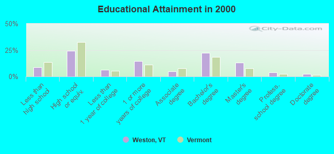
For population 25 years and over in Weston:
- High school or higher: 91.4%
- Bachelor's degree or higher: 41.6%
- Graduate or professional degree: 19.3%
- Unemployed: 1.8%
- Mean travel time to work (commute): 35.4 minutes
| Here: | 12.7 |
| Vermont average: | 11.7 |
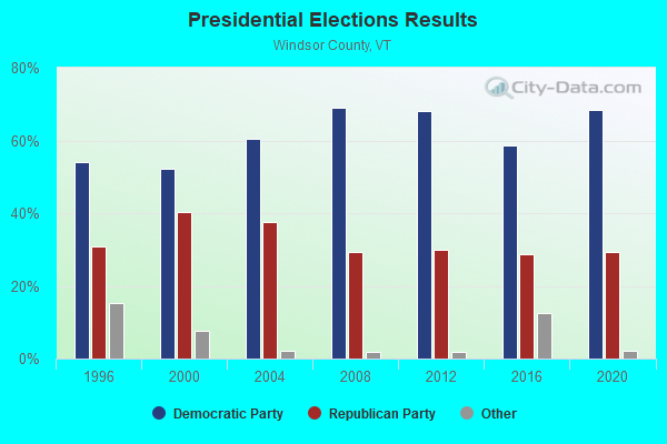
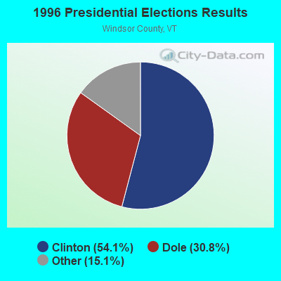
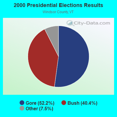
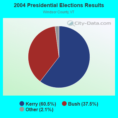
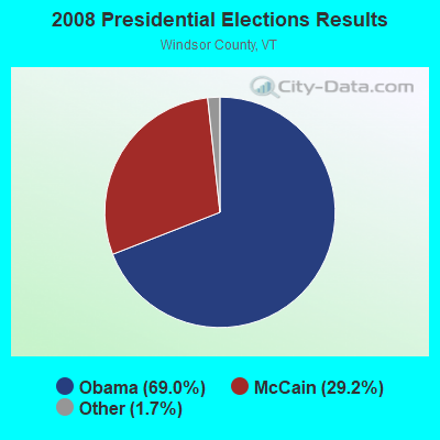
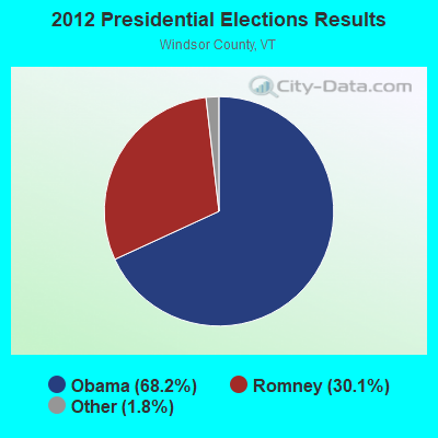
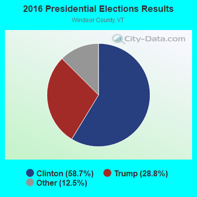
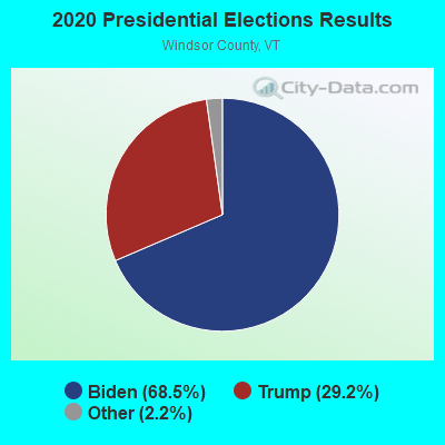
Graphs represent county-level data. Detailed 2008 Election Results
Religion statistics for Weston, VT (based on Windsor County data)
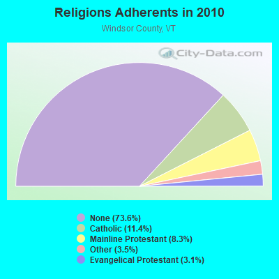
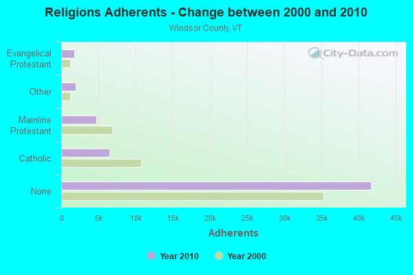
| Religion | Adherents | Congregations |
|---|---|---|
| Catholic | 6,485 | 10 |
| Mainline Protestant | 4,700 | 45 |
| Other | 1,964 | 17 |
| Evangelical Protestant | 1,750 | 21 |
| Orthodox | 55 | 1 |
| None | 41,716 | - |
Food Environment Statistics:
| Windsor County: | 4.93 / 10,000 pop. |
| Vermont: | 3.84 / 10,000 pop. |
| Windsor County: | 1.23 / 10,000 pop. |
| Vermont: | 1.95 / 10,000 pop. |
| Here: | 7.93 / 10,000 pop. |
| Vermont: | 6.40 / 10,000 pop. |
| Here: | 14.97 / 10,000 pop. |
| Vermont: | 11.52 / 10,000 pop. |
| This county: | 7.1% |
| Vermont: | 6.8% |
| Windsor County: | 22.8% |
| Vermont: | 22.3% |
| Windsor County: | 9.7% |
| Vermont: | 13.3% |
Strongest AM radio stations in Weston:
- WNBX (1480 AM; 5 kW; SPRINGFIELD, VT)
- WNNZ (640 AM; 50 kW; WESTFIELD, MA; Owner: CLEAR CHANNEL BROADCASTING LICENSES, INC.)
- WGY (810 AM; 50 kW; SCHENECTADY, NY; Owner: CLEAR CHANNEL BROADCASTING LICENSES, INC.)
- WNTK (1020 AM; 10 kW; NEWPORT, NH; Owner: KOOR COMMUNICATIONS, INC.)
- WCRN (830 AM; 50 kW; WORCESTER, MA; Owner: CARTER BROADCASTING CORPORATION)
- WPTR (1540 AM; 50 kW; ALBANY, NY; Owner: KIMTRON, INC.)
- WSYB (1380 AM; 5 kW; RUTLAND, VT; Owner: CAPSTAR TX LIMITED PARTNERSHIP)
- WRKO (680 AM; 50 kW; BOSTON, MA; Owner: ENTERCOM BOSTON LICENSE, LLC)
- WEEI (850 AM; 50 kW; BOSTON, MA; Owner: ENTERCOM BOSTON LICENSE, LLC)
- WVNE (760 AM; daytime; 25 kW; LEICESTER, MA; Owner: BLOUNT MASSCOM, INC.)
- WKOX (1200 AM; 50 kW; FRAMINGHAM, MA; Owner: CAPSTAR TX LIMITED PARTNERSHIP)
- WTIC (1080 AM; 50 kW; HARTFORD, CT; Owner: INFINITY RADIO OPERATIONS INC.)
- WALE (990 AM; 50 kW; GREENVILLE, RI; Owner: NORTH AMERICAN BROADCASTING CO., INC.)
Strongest FM radio stations in Weston:
- WEQX (102.7 FM; MANCHESTER, VT; Owner: NORTHSHIRE COMMUNICATIONS, INC.)
- WJAN (95.1 FM; SUNDERLAND, VT; Owner: 6 JOHNSON ROAD LICENSES, INC.)
- WJJR (98.1 FM; RUTLAND, VT; Owner: 6 JOHNSON ROAD LICENSES, INC.)
- WZRT (97.1 FM; RUTLAND, VT; Owner: CAPSTAR TX LIMITED PARTNERSHIP)
- WVPR (89.5 FM; WINDSOR, VT; Owner: VERMONT PUBLIC RADIO)
- WEBK (105.3 FM; KILLINGTON, VT; Owner: 6 JOHNSON ROAD LICENSES, INC.)
- WGLV (91.7 FM; WOODSTOCK, VT; Owner: CHRISTIAN MINISTRIES INC)
- WHDQ-FM1 (106.1 FM; RUTLAND, VT; Owner: GREAT NORTHERN RADIO, L.L.C.)
- WHDQ (106.1 FM; CLAREMONT, NH; Owner: GREAT NORTHERN RADIO, L.L.C.)
- WVAY (100.7 FM; WILMINGTON, VT; Owner: GREAT NORTHERN RADIO, L.L.C.)
- WVRR (101.7 FM; NEWPORT, NH; Owner: CAPSTAR TX LIMITED PARTNERSHIP)
- WJEN (94.5 FM; RUTLAND, VT; Owner: 6 JOHNSON ROAD LICENSES, INC.)
- WCFR-FM (96.3 FM; WALPOLE, NH; Owner: GREAT NORTHERN RADIO, LLC)
- WKNE (103.7 FM; KEENE, NH; Owner: SAGA COMMUNICATIONS OF NEW ENGLAND, LLC)
- WNGN (91.9 FM; ARGYLE, NY; Owner: NORTHEAST GOSPEL BROADCASTING INC)
- WXKK (93.5 FM; SPRINGFIELD, VT; Owner: CLEAR CHANNEL BROADCASTING LICENSES, INC.)
- WEVN (90.7 FM; KEENE, NH; Owner: NEW HAMPSHIRE PUBLIC RADIO, INC.)
- WAMC-FM (90.3 FM; ALBANY, NY; Owner: WAMC)
- WCMK (91.9 FM; PUTNEY, VT; Owner: CHRISTIAN MINISTRIES INC)
- WEXP (101.5 FM; BRANDON, VT; Owner: VOX VERMONT, L.L.C.)
TV broadcast stations around Weston:
- WVTA (Channel 41; WINDSOR, VT; Owner: VERMONT ETV, INC.)
- WEKW-TV (Channel 52; KEENE, NH; Owner: UNIVERSITY OF NEW HAMPSHIRE)
- WNNE (Channel 31; HARTFORD, VT; Owner: HEARST-ARGYLE STATIONS, INC.)
- W17CI (Channel 17; CLAREMONT, NH; Owner: UPPER VALLEY BROADCASTING, LLC)
Weston fatal accident list:
Aug 31, 1983 06:35 PM, Vt100, Vehicles: 1, Persons: 3, Fatalities: 2, Drunk persons involved: 1
- National Bridge Inventory (NBI) Statistics
- 9Number of bridges
- 46ft / 14.5mTotal length
- $1,886,000Total costs
- 6,565Total average daily traffic
- 571Total average daily truck traffic
- 6,896Total future (year 2028) average daily traffic
FCC Registered Broadcast Land Mobile Towers:
1- TOWN GARAGE, 48 Greendale Rd (Lat: 43.317972 Lon: -72.791222), Type: Building, Structure height: 5 m, Overall height: 13 m, Call Sign: KNJQ381,
Assigned Frequencies: 153.860 MHz, Grant Date: 06/12/2015, Expiration Date: 08/22/2025, Certifier: Donald W Hart, Registrant: Noe Electronics, 187 Banning Road, Putney, VT 05346, Phone: (802) 387-4666, Email:
FCC Registered Amateur Radio Licenses:
5- Call Sign: K1GCV, Licensee ID: L01308161, Grant Date: 08/29/2017, Expiration Date: 10/21/2027, Certifier: Andrew D Clapp, Registrant: Andrew D Clapp, 39 Lawrence Hill Road, Weston, VT 05161
- Call Sign: K1XV, Previous Call Sign: AB2DO, Licensee ID: L00151099, Grant Date: 02/22/2017, Expiration Date: 05/20/2027, Certifier: Raymond E Makul, Registrant: Raymond E Makul, Weston, VT 05161-0056
- Call Sign: W1AKV, Licensee ID: L00205842, Grant Date: 06/15/2007, Expiration Date: 09/09/2017, Cancellation Date: 09/10/2019, Certifier: John W Soderberg, Registrant: John W Soderberg, Box 127 Chester Rd, Weston, VT 05161-0127
- Call Sign: W1SMC, Previous Call Sign: KA1TOU, Licensee ID: L00179138, Grant Date: 04/04/2019, Expiration Date: 06/10/2029, Certifier: Steven M Campisano, Registrant: Steven M Campisano, 24 Burton Rd., Weston, VT 05161
- Call Sign: W1ORR, Previous Call Sign: KC1HST, Licensee ID: L02109843, Grant Date: 07/04/2017, Expiration Date: 07/04/2027, Certifier: Shawn W Orr, Registrant: Shawn W Orr, 278 Lawrence Hill Rd, Weston, VT 05161
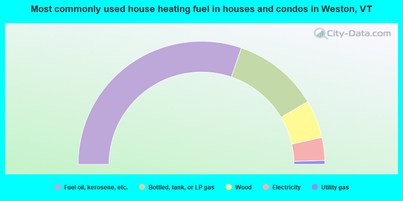
- 60.5%Fuel oil, kerosene, etc.
- 22.5%Bottled, tank, or LP gas
- 10.0%Wood
- 6.0%Electricity
- 1.0%Utility gas
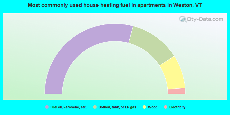
- 58.3%Fuel oil, kerosene, etc.
- 23.6%Bottled, tank, or LP gas
- 15.3%Wood
- 2.8%Electricity
Weston compared to Vermont state average:
- Unemployed percentage significantly below state average.
- Black race population percentage significantly below state average.
- Hispanic race population percentage significantly below state average.
- Median age significantly above state average.
- Foreign-born population percentage below state average.
- Renting percentage below state average.
- Length of stay since moving in significantly above state average.
- Number of rooms per house significantly below state average.
- House age significantly below state average.
- Number of college students significantly below state average.

|
Total of 5 patent applications in 2008-2024.