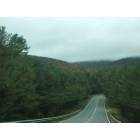
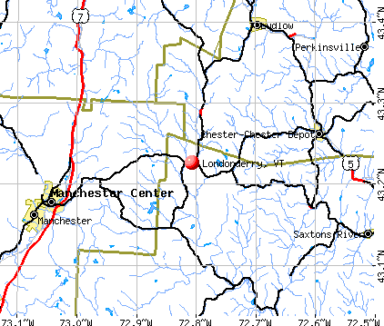
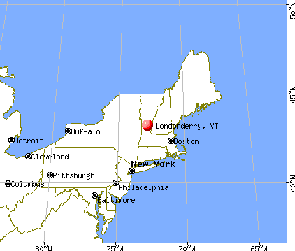
Londonderry, Vermont
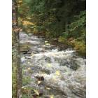
Londonderry: Londonderry, Vt - River View on Thompsonburg Road
Londonderry: Londonderry, Vt - River View on Thompsonburg Road
- add
your
Submit your own pictures of this town and show them to the world
- OSM Map
- General Map
- Google Map
- MSN Map
Population change since 2000: +3.5%
 |
| Males: 880 | |
| Females: 889 |
| Median resident age: | 46.0 years |
| Vermont median age: | 45.8 years |
Zip codes: 05155.
| Londonderry: | $73,102 |
| VT: | $73,991 |
Estimated per capita income in 2022: $48,169 (it was $24,220 in 2000)
Londonderry town income, earnings, and wages data
Estimated median house or condo value in 2022: $332,886 (it was $133,800 in 2000)
| Londonderry: | $332,886 |
| VT: | $304,700 |
Mean prices in 2022: all housing units: $298,935; detached houses: $317,292; townhouses or other attached units: $299,018; in 2-unit structures: $292,940; in 3-to-4-unit structures: $427,770; in 5-or-more-unit structures: $214,034; mobile homes: $65,502
Detailed information about poverty and poor residents in Londonderry, VT


- 1,71897.1%White alone
- 181.0%Hispanic
- 140.8%Two or more races
- 120.7%Asian alone
- 60.3%Black alone
- 10.06%American Indian alone

Races in Londonderry detailed stats: ancestries, foreign born residents, place of birth
According to our research of Vermont and other state lists, there were 4 registered sex offenders living in Londonderry, Vermont as of May 28, 2024.
The ratio of all residents to sex offenders in Londonderry is 442 to 1.
The ratio of registered sex offenders to all residents in this city is near the state average.
 Recent articles from our blog. Our writers, many of them Ph.D. graduates or candidates, create easy-to-read articles on a wide variety of topics.

 | Vermont Weather (3779 replies) |
| Windsor County (Andover/Ludlow area) (2 replies) |
| Florida family wanting to move to Vermont (15 replies) |
| Southeastern Vermont: Yay or Nay? (12 replies) |
| Weston information (6 replies) |
| Living in Manchester Vermont (45 replies) |
Latest news from Londonderry, VT collected exclusively by city-data.com from local newspapers, TV, and radio stations
Ancestries: English (22.0%), Irish (15.6%), German (14.6%), United States (9.9%), French (7.8%), Italian (6.0%).
Current Local Time: EST time zone
Elevation: 1151 feet
Land area: 35.7 square miles.
Population density: 50 people per square mile (very low).
70 residents are foreign born (2.6% Europe, 0.6% North America, 0.6% Asia).
| This town: | 4.1% |
| Vermont: | 3.8% |
| Londonderry town: | 1.7% ($2,246) |
| Vermont: | 2.0% ($2,196) |
Nearest city with pop. 50,000+: Albany, NY  (61.9 miles , pop. 95,658).
Nearest city with pop. 200,000+: Boston, MA (106.8 miles , pop. 589,141).
Nearest city with pop. 1,000,000+: Bronx, NY (172.0 miles , pop. 1,332,650).
Nearest cities:
), ), ), ), ), Latitude: 43.21 N, Longitude: 72.81 W
Area code commonly used in this area: 802


Single-family new house construction building permits:
- 2022: 8 buildings, average cost: $279,200
- 2021: 8 buildings, average cost: $239,300
- 2020: 3 buildings, average cost: $248,200
- 2019: 1 building, cost: $165,000
- 2018: 4 buildings, average cost: $165,000
- 2017: 2 buildings, average cost: $630,500
- 2016: 2 buildings, average cost: $420,500
- 2015: 3 buildings, average cost: $721,000
- 2014: 5 buildings, average cost: $309,000
- 2013: 3 buildings, average cost: $491,700
- 2012: 8 buildings, average cost: $160,600
- 2011: 10 buildings, average cost: $160,100
- 2010: 10 buildings, average cost: $163,800
- 2009: 6 buildings, average cost: $145,500
- 2008: 16 buildings, average cost: $206,500
- 2007: 27 buildings, average cost: $202,000
- 2006: 18 buildings, average cost: $237,600
- 2005: 20 buildings, average cost: $198,900
- 2004: 22 buildings, average cost: $186,600
- 2003: 13 buildings, average cost: $196,300
- 2002: 30 buildings, average cost: $203,300
- 2001: 21 buildings, average cost: $167,500
- 2000: 9 buildings, average cost: $185,600
- 1999: 13 buildings, average cost: $170,800
- 1998: 5 buildings, average cost: $374,000
- 1997: 8 buildings, average cost: $181,900


| Here: | 2.4% |
| Vermont: | 2.0% |


- Accommodation & food services (20.2%)
- Construction (16.6%)
- Educational services (7.1%)
- Health care (5.1%)
- Arts, entertainment, recreation (4.0%)
- Administrative & support & waste management services (3.5%)
- Food & beverage stores (3.5%)

- Construction (27.1%)
- Accommodation & food services (21.3%)
- Arts, entertainment, recreation (5.2%)
- Administrative & support & waste management services (4.2%)
- Educational services (3.8%)
- Agriculture, forestry, fishing & hunting (3.7%)
- Wood products (3.3%)

- Accommodation & food services (18.6%)
- Educational services (11.3%)
- Health care (10.8%)
- Private households (5.5%)
- Food & beverage stores (5.3%)
- Finance & insurance (4.5%)
- Professional, scientific, technical services (4.3%)

- Other management occupations, except farmers and farm managers (7.8%)
- Building and grounds cleaning and maintenance occupations (7.3%)
- Other sales and related occupations, including supervisors (7.2%)
- Carpenters (5.7%)
- Supervisors and other personal care and service workers, except child care workers (2.7%)
- Other office and administrative support workers, including supervisors (2.7%)
- Waiters and waitresses (2.7%)

- Other management occupations, except farmers and farm managers (9.6%)
- Carpenters (9.6%)
- Other sales and related occupations, including supervisors (8.1%)
- Building and grounds cleaning and maintenance occupations (6.3%)
- Driver/sales workers and truck drivers (4.0%)
- Construction laborers (3.8%)
- Supervisors, construction and extraction workers (3.8%)

- Building and grounds cleaning and maintenance occupations (8.5%)
- Other sales and related occupations, including supervisors (6.0%)
- Other management occupations, except farmers and farm managers (5.5%)
- Registered nurses (5.3%)
- Other office and administrative support workers, including supervisors (4.8%)
- Preschool, kindergarten, elementary, and middle school teachers (4.0%)
- Bookkeeping, accounting, and auditing clerks (3.8%)
Average climate in Londonderry, Vermont
Based on data reported by over 4,000 weather stations


Tornado activity:
Londonderry-area historical tornado activity is above Vermont state average. It is 47% smaller than the overall U.S. average.
On 8/20/1968, a category F3 (max. wind speeds 158-206 mph) tornado 7.4 miles away from the Londonderry town center injured one person and caused between $5000 and $50,000 in damages.
On 5/31/1998, a category F3 tornado 26.6 miles away from the town center injured 68 people and caused $71 million in damages.
Earthquake activity:
Londonderry-area historical earthquake activity is significantly above Vermont state average. It is 69% smaller than the overall U.S. average.On 10/7/1983 at 10:18:46, a magnitude 5.3 (5.1 MB, 5.3 LG, 5.1 ML, Class: Moderate, Intensity: VI - VII) earthquake occurred 92.4 miles away from Londonderry center
On 4/20/2002 at 10:50:47, a magnitude 5.3 (5.3 ML, Depth: 3.0 mi) earthquake occurred 100.6 miles away from the city center
On 4/20/2002 at 10:50:47, a magnitude 5.2 (5.2 MB, 4.2 MS, 5.2 MW, 5.0 MW) earthquake occurred 99.4 miles away from the city center
On 1/19/1982 at 00:14:42, a magnitude 4.7 (4.5 MB, 4.7 MD, 4.5 LG, Class: Light, Intensity: IV - V) earthquake occurred 64.3 miles away from the city center
On 10/16/2012 at 23:12:25, a magnitude 4.7 (4.7 ML, Depth: 10.0 mi) earthquake occurred 111.7 miles away from Londonderry center
On 6/17/1991 at 08:53:16, a magnitude 4.1 (4.0 MB, 4.0 LG, Depth: 3.1 mi) earthquake occurred 102.5 miles away from Londonderry center
Magnitude types: regional Lg-wave magnitude (LG), body-wave magnitude (MB), duration magnitude (MD), local magnitude (ML), surface-wave magnitude (MS), moment magnitude (MW)
Natural disasters:
The number of natural disasters in Windham County (16) is near the US average (15).Major Disasters (Presidential) Declared: 13
Emergencies Declared: 2
Causes of natural disasters: Floods: 11, Storms: 10, Tropical Storms: 2, Hurricane: 1, Landslide: 1, Snowstorm: 1, Wind: 1, Winter Storm: 1 (Note: some incidents may be assigned to more than one category).

Colleges/universities with over 2000 students nearest to Londonderry:
- Keene State College (about 34 miles; Keene, NH; Full-time enrollment: 5,098)
- Castleton State College (about 34 miles; Castleton, VT; FT enrollment: 2,079)
- Williams College (about 40 miles; Williamstown, MA; FT enrollment: 2,141)
- Dartmouth College (about 44 miles; Hanover, NH; FT enrollment: 6,030)
- Adirondack Community College (about 44 miles; Queensbury, NY; FT enrollment: 2,826)
- Franklin Pierce University (about 49 miles; Rindge, NH; FT enrollment: 2,139)
- SUNY Empire State College (about 50 miles; Saratoga Springs, NY; FT enrollment: 9,473)
Public elementary/middle school in Londonderry:
- FLOOD BROOK USD #301 (Students: 302, Location: 91 VT ROUTE 11, Grades: PK-8)
Points of interest:
Notable locations in Londonderry: Majic Mountain Ski Center (A), Camp Derry (B), Winhall Station (C), Viking Ski Touring Center (D), Viking Cross Country Ski Area (E), Ball Mountain Dam Picnic Grounds (F), Magic Mountain Winter Sports Area (G), Viking Winter Sports Area (H), South Londonderry Free Library (I), Champion Fire Company 5 (J), Phoenix Fire Company 6 (K), Londonderry Volunteer Rescue Squad (L). Display/hide their locations on the map
Churches in Londonderry include: First Baptist Church (A), Second Congregational Church (B). Display/hide their locations on the map
Cemeteries: Lowell Lake Cemetery (1), Middletown Cemetery (2), Stowell Cemetery (3), Stevens Cemetery (4), Staples Cemetery (5), Riverside Cemetery (6), Osgood-Chubbuck Cemetery (7). Display/hide their locations on the map
Lakes and reservoirs: Lily Pond (A), Lowell Lake (B). Display/hide their locations on the map
Streams, rivers, and creeks: Winhall River (A), Utley Brook (B), Cook Brook (C), Burnt Meadow Brook (D), Flood Brook (E), Eddy Brook (F). Display/hide their locations on the map
Park in Londonderry: South Londonderry Village Historic District (1). Display/hide its location on the map
Hotels: Blue Gentian Lodge (Magic Mountain Road) (1), Landgrove Inn (215 Landgrove Road) (2), Greenmount Lodge (Landgrove Hollow Road) (3). Display/hide their approximate locations on the map
Birthplace of: Harrison Henry Atwood - Politician, Ernest Willard Gibson - Politician, Mike Wilson (skier) - Skier.
Drinking water stations with addresses in Londonderry and their reported violations in the past:
MAGIC MOUNTAIN (Population served: 502, Groundwater):Past health violations:FLOOD BROOK USD 20 (Population served: 400, Groundwater):Past monitoring violations:
- MCL, Monthly (TCR) - In JUL-2012, Contaminant: Coliform. Follow-up actions: St Tech Assistance Visit (JUL-27-2012), St Formal NOV issued (JUL-27-2012), St Public Notif requested (JUL-27-2012), St Boil Water Order (JUL-27-2012), St Compliance achieved (AUG-24-2012)
- 4 routine major monitoring violations
- 3 regular monitoring violations
Past monitoring violations:UPPER PASS LODGE (Address: 420 MAGIC MOUNTAIN ACCESS RD , Population served: 150, Groundwater):
- One regular monitoring violation
Past monitoring violations:TRAILSIDE AT MAGIC MOUNTAIN (Address: 113 TRAILSIDE B13 , Population served: 150, Groundwater):
- 16 routine major monitoring violations
- 4 regular monitoring violations
Past monitoring violations:SWISS INN (Address: 249 ROUTE 11 , Population served: 114, Groundwater):
- Monitoring and Reporting (DBP) - Between OCT-2009 and DEC-2009, Contaminant: Chlorine. Follow-up actions: St Public Notif requested (MAR-01-2010), St Formal NOV issued (MAR-01-2010), St Public Notif received (JUN-09-2010), St Compliance achieved (MAR-22-2011)
- One routine major monitoring violation
Past monitoring violations:SNOWDON MOTEL (Address: 4071 ROUTE 11 , Population served: 108, Groundwater):
- Monitoring, Repeat Major (TCR) - Between OCT-2008 and DEC-2008, Contaminant: Coliform (TCR). Follow-up actions: St Formal NOV issued (JAN-22-2009), St Public Notif requested (JAN-22-2009), St Compliance achieved (AUG-09-2010)
- One routine major monitoring violation
Past health violations:BLUE GENTIAN LODGE (Address: 289 MAGIC MTN RD , Population served: 82, Groundwater):Past monitoring violations:
- MCL, Monthly (TCR) - In JUL-2012, Contaminant: Coliform. Follow-up actions: St Public Notif requested (JUL-16-2012), St Formal NOV issued (JUL-16-2012), St Compliance achieved (JAN-17-2014)
- MCL, Monthly (TCR) - In FEB-2009, Contaminant: Coliform. Follow-up actions: St Public Notif requested (FEB-10-2009), St Formal NOV issued (FEB-10-2009), St Compliance achieved (NOV-04-2010), St Public Notif received (DEC-21-2010)
- MCL, Monthly (TCR) - In APR-2007, Contaminant: Coliform. Follow-up actions: St Tech Assistance Visit (APR-27-2007), St Formal NOV issued (APR-27-2007), St Boil Water Order (APR-27-2007), St Public Notif requested (APR-27-2007), St Compliance achieved (NOV-04-2010), St Public Notif received (DEC-21-2010)
- Monitoring, Source Water (GWR) - In JUL-04-2012, Contaminant: E. COLI. Follow-up actions: St Formal NOV issued (JUL-25-2012), St Compliance achieved (JAN-17-2014)
- Monitoring, Repeat Major (TCR) - Between JAN-2009 and MAR-2009, Contaminant: Coliform (TCR). Follow-up actions: St Public Notif requested (APR-23-2009), St Formal NOV issued (APR-23-2009), St Compliance achieved (NOV-04-2010), St Public Notif received (DEC-21-2010)
- Monitoring, Repeat Major (TCR) - Between OCT-2007 and DEC-2007, Contaminant: Coliform (TCR). Follow-up actions: St Public Notif requested (JAN-22-2008), St Formal NOV issued (JAN-22-2008), St Compliance achieved (NOV-04-2010), St Public Notif received (DEC-21-2010)
- Monitoring, Repeat Major (TCR) - Between JAN-2007 and MAR-2007, Contaminant: Coliform (TCR). Follow-up actions: St Public Notif requested (APR-16-2007), St Formal NOV issued (APR-16-2007), St Compliance achieved (NOV-04-2010), St Public Notif received (DEC-21-2010)
- 17 routine major monitoring violations
- 2 minor monitoring violations
- 2 regular monitoring violations
Past health violations:FROGS LEAP INN (Address: 7455 RTE 100 , Population served: 71, Groundwater):Past monitoring violations:
- MCL, Monthly (TCR) - In JUL-2009, Contaminant: Coliform. Follow-up actions: St Tech Assistance Visit (JUL-22-2009), St Formal NOV issued (JUL-22-2009), St Public Notif requested (JUL-22-2009), St Boil Water Order (JUL-22-2009), St Compliance achieved (FEB-07-2011)
- MCL, Monthly (TCR) - In DEC-2006, Contaminant: Coliform. Follow-up actions: St Tech Assistance Visit (DEC-18-2006), St Formal NOV issued (DEC-18-2006), St Public Notif requested (DEC-18-2006), St Boil Water Order (DEC-18-2006), St Compliance achieved (FEB-07-2011)
- MCL, Monthly (TCR) - Between OCT-2006 and DEC-2006, Contaminant: Coliform. Follow-up actions: St Tech Assistance Visit (NOV-08-2006), St Boil Water Order (NOV-08-2006), St Public Notif requested (NOV-08-2006), St Formal NOV issued (NOV-08-2006), St Compliance achieved (APR-06-2007)
- One routine major monitoring violation
Past health violations:Past monitoring violations:
- MCL, Monthly (TCR) - In DEC-2009, Contaminant: Coliform. Follow-up actions: St Public Notif received (DEC-01-2009), St Formal NOV issued (JAN-11-2010), St Public Notif requested (JAN-11-2010), St Compliance achieved (NOV-22-2010)
- Monitoring, Repeat Major (TCR) - Between JUL-2009 and SEP-2009, Contaminant: Coliform (TCR). Follow-up actions: St Formal NOV issued (NOV-02-2009), St Public Notif requested (NOV-02-2009), St Public Notif received (DEC-01-2009), St Compliance achieved (NOV-22-2010)
- 4 routine major monitoring violations
| This town: | 2.2 people |
| Vermont: | 2.3 people |
| This town: | 62.4% |
| Whole state: | 62.5% |
| This town: | 9.1% |
| Whole state: | 9.2% |
Likely homosexual households (counted as self-reported same-sex unmarried-partner households)
- Lesbian couples: 0.5% of all households
- Gay men: 0.4% of all households
| This town: | 6.3% |
| Whole state: | 9.4% |
| This town: | 2.6% |
| Whole state: | 3.6% |
Banks with branches in Londonderry (2011 data):
- People's United Bank: Londonderry Branch at 5700 Vt Route 100, C6, branch established on 1969/07/14. Info updated 2012/02/16: Bank assets: $27,319.3 mil, Deposits: $20,835.4 mil, headquarters in Bridgeport, CT, positive income, Commercial Lending Specialization, 374 total offices
For population 15 years and over in Londonderry:

- Never married: 23.4%
- Now married: 57.8%
- Separated: 1.9%
- Widowed: 6.2%
- Divorced: 10.7%
For population 25 years and over in Londonderry:
- High school or higher: 88.2%
- Bachelor's degree or higher: 29.6%
- Graduate or professional degree: 8.4%
- Unemployed: 2.9%
- Mean travel time to work (commute): 21.1 minutes


| Here: | 10.7 |
| Vermont average: | 11.7 |
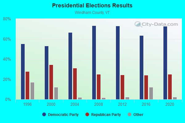
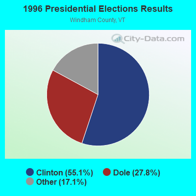
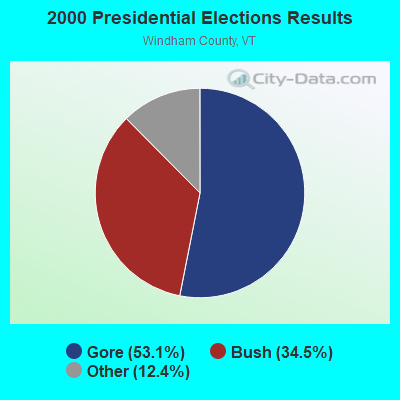
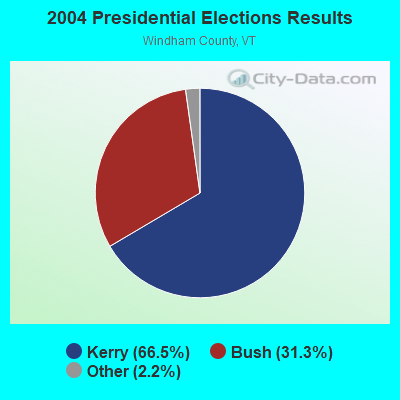
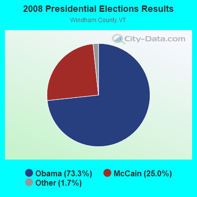

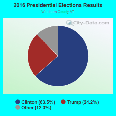
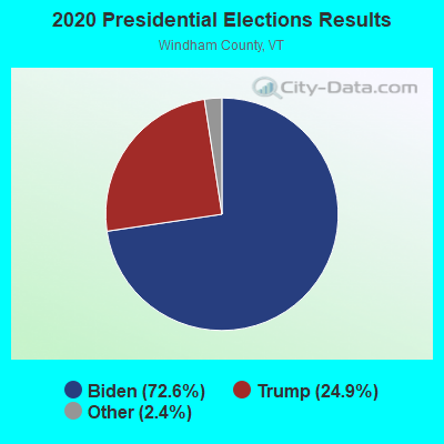
Graphs represent county-level data. Detailed 2008 Election Results
Religion statistics for Londonderry, VT (based on Windham County data)
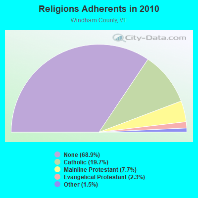
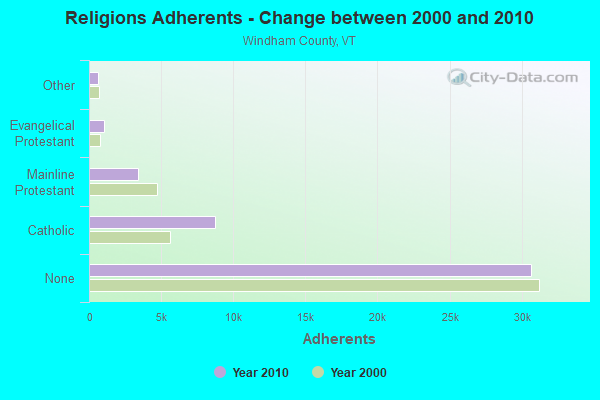
| Religion | Adherents | Congregations |
|---|---|---|
| Catholic | 8,753 | 8 |
| Mainline Protestant | 3,412 | 38 |
| Evangelical Protestant | 1,026 | 13 |
| Other | 647 | 12 |
| None | 30,675 | - |
Food Environment Statistics:
| Windham County: | 4.14 / 10,000 pop. |
| Vermont: | 3.84 / 10,000 pop. |
| This county: | 1.38 / 10,000 pop. |
| Vermont: | 1.95 / 10,000 pop. |
| Windham County: | 7.37 / 10,000 pop. |
| Vermont: | 6.40 / 10,000 pop. |
| Windham County: | 18.87 / 10,000 pop. |
| State: | 11.52 / 10,000 pop. |
| Windham County: | 6.7% |
| State: | 6.8% |
| Windham County: | 22.6% |
| Vermont: | 22.3% |
| Windham County: | 12.5% |
| Vermont: | 13.3% |
Businesses in Londonderry, VT
- U-Haul: 1
Strongest AM radio stations in Londonderry:
- WNNZ (640 AM; 50 kW; WESTFIELD, MA; Owner: CLEAR CHANNEL BROADCASTING LICENSES, INC.)
- WGY (810 AM; 50 kW; SCHENECTADY, NY; Owner: CLEAR CHANNEL BROADCASTING LICENSES, INC.)
- WNBX (1480 AM; 5 kW; SPRINGFIELD, VT)
- WCRN (830 AM; 50 kW; WORCESTER, MA; Owner: CARTER BROADCASTING CORPORATION)
- WNTK (1020 AM; 10 kW; NEWPORT, NH; Owner: KOOR COMMUNICATIONS, INC.)
- WPTR (1540 AM; 50 kW; ALBANY, NY; Owner: KIMTRON, INC.)
- WRKO (680 AM; 50 kW; BOSTON, MA; Owner: ENTERCOM BOSTON LICENSE, LLC)
- WEEI (850 AM; 50 kW; BOSTON, MA; Owner: ENTERCOM BOSTON LICENSE, LLC)
- WVNE (760 AM; daytime; 25 kW; LEICESTER, MA; Owner: BLOUNT MASSCOM, INC.)
- WTIC (1080 AM; 50 kW; HARTFORD, CT; Owner: INFINITY RADIO OPERATIONS INC.)
- WKOX (1200 AM; 50 kW; FRAMINGHAM, MA; Owner: CAPSTAR TX LIMITED PARTNERSHIP)
- WSYB (1380 AM; 5 kW; RUTLAND, VT; Owner: CAPSTAR TX LIMITED PARTNERSHIP)
- WALE (990 AM; 50 kW; GREENVILLE, RI; Owner: NORTH AMERICAN BROADCASTING CO., INC.)
Strongest FM radio stations in Londonderry:
- WEQX (102.7 FM; MANCHESTER, VT; Owner: NORTHSHIRE COMMUNICATIONS, INC.)
- WJAN (95.1 FM; SUNDERLAND, VT; Owner: 6 JOHNSON ROAD LICENSES, INC.)
- WVAY (100.7 FM; WILMINGTON, VT; Owner: GREAT NORTHERN RADIO, L.L.C.)
- WJJR (98.1 FM; RUTLAND, VT; Owner: 6 JOHNSON ROAD LICENSES, INC.)
- WZRT (97.1 FM; RUTLAND, VT; Owner: CAPSTAR TX LIMITED PARTNERSHIP)
- WVPR (89.5 FM; WINDSOR, VT; Owner: VERMONT PUBLIC RADIO)
- WEBK (105.3 FM; KILLINGTON, VT; Owner: 6 JOHNSON ROAD LICENSES, INC.)
- WHDQ (106.1 FM; CLAREMONT, NH; Owner: GREAT NORTHERN RADIO, L.L.C.)
- WGLV (91.7 FM; WOODSTOCK, VT; Owner: CHRISTIAN MINISTRIES INC)
- WHDQ-FM1 (106.1 FM; RUTLAND, VT; Owner: GREAT NORTHERN RADIO, L.L.C.)
- WCFR-FM (96.3 FM; WALPOLE, NH; Owner: GREAT NORTHERN RADIO, LLC)
- WCMK (91.9 FM; PUTNEY, VT; Owner: CHRISTIAN MINISTRIES INC)
- WKNE (103.7 FM; KEENE, NH; Owner: SAGA COMMUNICATIONS OF NEW ENGLAND, LLC)
- WAMC-FM (90.3 FM; ALBANY, NY; Owner: WAMC)
- WEVN (90.7 FM; KEENE, NH; Owner: NEW HAMPSHIRE PUBLIC RADIO, INC.)
- WVRR (101.7 FM; NEWPORT, NH; Owner: CAPSTAR TX LIMITED PARTNERSHIP)
- WNGN (91.9 FM; ARGYLE, NY; Owner: NORTHEAST GOSPEL BROADCASTING INC)
- WRSY (101.5 FM; MARLBORO, VT; Owner: GREAT NORTHERN RADIO, L.L.C.)
- WJEN (94.5 FM; RUTLAND, VT; Owner: 6 JOHNSON ROAD LICENSES, INC.)
- WKVT-FM (92.7 FM; BRATTLEBORO, VT; Owner: SAGA COMMUNICATIONS OF NEW ENGLAND, LLC)
TV broadcast stations around Londonderry:
- WEKW-TV (Channel 52; KEENE, NH; Owner: UNIVERSITY OF NEW HAMPSHIRE)
- WVTA (Channel 41; WINDSOR, VT; Owner: VERMONT ETV, INC.)
- Londonderry, Vermont
- Fatal accident count18
- Vehicles involved in fatal accidents26
- Fatal accidents involving drunk persons:10
- Fatalities19
- Persons involved in fatal accidents41
- Pedestrians involved in fatal accidents1
- Vermont average
- Fatal accident count1348
- Vehicles involved in fatal accidents1903
- Fatal accidents involving drunk persons603
- Fatalities1511
- Persons involved in fatal accidents3243
- Pedestrians involved in fatal accidents80
- National Bridge Inventory (NBI) Statistics
- 14Number of bridges
- 105ft / 31.7mTotal length
- $2,627,000Total costs
- 13,835Total average daily traffic
- 1,228Total average daily truck traffic
- 14,570Total future (year 2016) average daily traffic

- New bridges - historical statistics
- 11910-1919
- 21930-1939
- 11940-1949
- 21950-1959
- 11970-1979
- 11980-1989
- 51990-1999
- 12000-2009
FCC Registered Broadcast Land Mobile Towers:
4- .25 Mi From Int Rt 100 N & Rt 11 On Rt 100 N (Lat: 43.227583 Lon: -72.805944), Type: Bant, Structure height: 9 m, Call Sign: WXQ931,
Assigned Frequencies: 154.145 MHz, Grant Date: 01/18/2024, Expiration Date: 10/26/2033, Registrant: Swnh Fire Mutual Aid, 32 Vernon St., Keene, NH 03431, Phone: (603) 352-8635, Fax: (603) 357-1985, Email:
- Lat: 43.236333 Lon: -72.863889, Call Sign: WQDL618,
Assigned Frequencies: 72.1000 MHz, Grant Date: 09/26/2005, Expiration Date: 09/26/2015, Cancellation Date: 11/28/2015, Certifier: Wanda Mauti, Registrant: Business Radio Licensing, 26941 Cabot Road #134, Laguna Hills, CA 92653, Phone: (949) 348-8510, Fax: (949) 348-8514, Email:
- 278 Hells Peak Road (Lat: 43.231472 Lon: -72.809806), Call Sign: WRLC865,
Assigned Frequencies: 159.690 MHz, 160.185 MHz, Grant Date: 03/11/2021, Expiration Date: 03/11/2031, Certifier: Ryan Hart, Registrant: Cara Enterprises, Inc., Las Vegas, NV 89140-0124, Phone: (702) 838-9728, Fax: (702) 363-4607, Email:
- 495 Magic Mountain Access Road (Lat: 43.201389 Lon: -72.772778), Type: Bant, Structure height: 10 m, Overall height: 20 m, Call Sign: WRNR233,
Assigned Frequencies: 160.207 MHz, Grant Date: 08/11/2021, Expiration Date: 08/11/2031, Certifier: W Bourque, Registrant: National Ski Patrol System, Inc., 133 S Van Gordon Street, Lakewood, CO 80228, Phone: (303) 988-1111, Email:
FCC Registered Microwave Towers:
3- MagicMountain, Lat: 43.192389 Lon: -72.760361, Type: Tower, Structure height: 12.2 m, Overall height: 14.2 m, Call Sign: WQIG801,
Assigned Frequencies: 3650.00 MHz, Grant Date: 02/06/2008, Expiration Date: 02/06/2018, Cancellation Date: 04/21/2018, Certifier: Josh Garza, Registrant: Rini Coran, Pc, 1140 19th Street, Nw Suite 600, Washington, DC 20036, Phone: (202) 463-4310, Fax: (202) 296-2014, Email:
- GLEBE MTN, Atop Glebe Mountain (Lat: 43.188889 Lon: -72.761083), Type: Tank, Structure height: 50 m, Call Sign: WQVG707,
Assigned Frequencies: 10915.0 MHz, 11285.0 MHz, 6315.84 MHz, 6256.54 MHz, 6315.84 MHz, 6256.54 MHz, 6315.84 MHz, 6256.54 MHz, 6315.84 MHz, 6256.54 MHz... (+12 more), Grant Date: 02/06/2015, Expiration Date: 02/06/2025, Certifier: Phillip T Chitwood, Registrant: Vermont Transco LLC, 366 Pinnacle Ridge Road, Rutland, VT 05701, Phone: (802) 772-3777, Email:
- Londonderry-01, 495 Magic Mountain Access Road (Lat: 43.189444 Lon: -72.760528), Type: Ltower, Structure height: 42.7 m, Call Sign: WQVY517,
Assigned Frequencies: 10895.0 MHz, 10935.0 MHz, 11055.0 MHz, 11095.0 MHz, 10895.0 MHz, 10935.0 MHz, 11055.0 MHz, 11095.0 MHz, 10895.0 MHz, 10935.0 MHz... (+46 more), Grant Date: 06/15/2015, Expiration Date: 06/15/2025, Certifier: Fran Stocker, Registrant: Radyn, Inc, Silver Spring, MD 20914, Phone: (301) 493-5171, Fax: (301) 576-4553, Email:
FCC Registered Amateur Radio Licenses:
9 (See the full list of FCC Registered Amateur Radio Licenses in Londonderry)FAA Registered Aircraft:
3- Aircraft: MOONEY M20E (Category: Land, Seats: 4, Weight: Up to 12,499 Pounds, Speed: 127 mph), Engine: LYCOMING I0360 SER (180 HP) (Reciprocating)
N-Number: 20TU, N20TU, N-20TU, Serial Number: 159, Year manufactured: 1963, Airworthiness Date: 03/13/1967, Certificate Issue Date: 12/14/2015
Registrant (Co-Owned): John Skinner, 117 Boynton Rd, Londonderry, VT 05148, Other Owners: Cole Skinner - Aircraft: BEECH 95-B55 (T42A) (Category: Land, Engines: 2, Seats: 6, Weight: Up to 12,499 Pounds, Speed: 165 mph), Engine: CONT MOTOR I0-470 SERIES (260 HP) (Reciprocating)
N-Number: 341, N341, N-341, Serial Number: TC-2369, Year manufactured: 1981, Airworthiness Date: 01/13/1981, Certificate Issue Date: 02/01/2017
Registrant (Individual): Horace L Iii Trustee Shepard, 527 Landgrove Rd, Londonderry, VT 05148 - Aircraft: PIPER PA-28-181 (Category: Land, Seats: 4, Weight: Up to 12,499 Pounds, Speed: 105 mph), Engine: LYCOMING O&VO-360 SER (180 HP) (Reciprocating)
N-Number: 9629C, N9629C, N-9629C, Serial Number: 28-7890430, Year manufactured: 1978, Airworthiness Date: 03/20/1978, Certificate Issue Date: 12/07/2006
Registrant (Individual): Walter Genser, Po Box 548, Londonderry, VT 05148

- 66.1%Fuel oil, kerosene, etc.
- 17.6%Bottled, tank, or LP gas
- 11.2%Wood
- 3.0%Electricity
- 1.7%Utility gas
- 0.4%Other fuel

- 56.9%Fuel oil, kerosene, etc.
- 16.3%Bottled, tank, or LP gas
- 13.9%Wood
- 11.9%Electricity
- 1.0%Other fuel
Londonderry compared to Vermont state average:
- Unemployed percentage significantly below state average.
- Black race population percentage below state average.
- Hispanic race population percentage below state average.
- Length of stay since moving in significantly above state average.
- Number of rooms per house significantly below state average.
- House age significantly below state average.
- Number of college students below state average.

|
Total of 2 patent applications in 2008-2024.