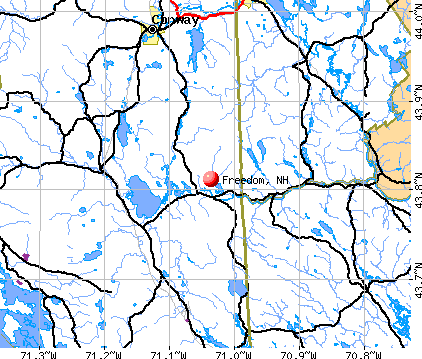
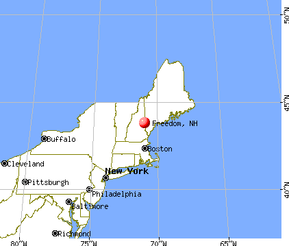
Freedom, New Hampshire
Submit your own pictures of this town and show them to the world
- OSM Map
- General Map
- Google Map
- MSN Map
Population change since 2000: +14.3%
 |
| Males: 750 | |
| Females: 739 |
| Median resident age: | 53.1 years |
| New Hampshire median age: | 43.9 years |
Zip codes: 03836.
| Freedom: | $76,703 |
| NH: | $89,992 |
Estimated per capita income in 2022: $51,709 (it was $23,036 in 2000)
Freedom town income, earnings, and wages data
Estimated median house or condo value in 2022: $424,945 (it was $138,900 in 2000)
| Freedom: | $424,945 |
| NH: | $384,700 |
Mean prices in 2022: all housing units: $505,201; detached houses: $542,950; townhouses or other attached units: $363,532; in 2-unit structures: $373,773; in 3-to-4-unit structures: $587,160; in 5-or-more-unit structures: $313,992; mobile homes: $113,714; occupied boats, rvs, vans, etc.: $118,400
Detailed information about poverty and poor residents in Freedom, NH


- 1,46798.5%White alone
- 80.5%Two or more races
- 80.5%Hispanic
- 40.3%Asian alone
- 20.1%Black alone

Races in Freedom detailed stats: ancestries, foreign born residents, place of birth
According to our research of New Hampshire and other state lists, there was 1 registered sex offender living in Freedom, New Hampshire as of May 28, 2024.
The ratio of all residents to sex offenders in Freedom is 1,489 to 1.
The ratio of registered sex offenders to all residents in this city is much lower than the state average.
Type |
2009 |
2010 |
2011 |
2012 |
2013 |
2014 |
2015 |
2016 |
2017 |
2018 |
2019 |
2020 |
2021 |
2022 |
|---|---|---|---|---|---|---|---|---|---|---|---|---|---|---|
| Murders (per 100,000) | 0 (0.0) | 0 (0.0) | 0 (0.0) | 0 (0.0) | 0 (0.0) | 0 (0.0) | 0 (0.0) | 0 (0.0) | 0 (0.0) | 0 (0.0) | 0 (0.0) | 0 (0.0) | 0 (0.0) | 0 (0.0) |
| Rapes (per 100,000) | 0 (0.0) | 0 (0.0) | 0 (0.0) | 0 (0.0) | 1 (67.4) | 0 (0.0) | 0 (0.0) | 0 (0.0) | 0 (0.0) | 0 (0.0) | 0 (0.0) | 0 (0.0) | 0 (0.0) | 0 (0.0) |
| Robberies (per 100,000) | 0 (0.0) | 0 (0.0) | 0 (0.0) | 0 (0.0) | 0 (0.0) | 0 (0.0) | 0 (0.0) | 0 (0.0) | 0 (0.0) | 0 (0.0) | 0 (0.0) | 0 (0.0) | 0 (0.0) | 0 (0.0) |
| Assaults (per 100,000) | 0 (0.0) | 0 (0.0) | 0 (0.0) | 2 (134.6) | 0 (0.0) | 0 (0.0) | 0 (0.0) | 1 (67.3) | 0 (0.0) | 0 (0.0) | 0 (0.0) | 0 (0.0) | 0 (0.0) | 6 (339.6) |
| Burglaries (per 100,000) | 6 (414.4) | 6 (403.0) | 4 (268.3) | 6 (403.8) | 3 (202.3) | 0 (0.0) | 10 (672.5) | 1 (67.3) | 1 (67.2) | 4 (261.1) | 0 (0.0) | 0 (0.0) | 3 (187.1) | 1 (56.6) |
| Thefts (per 100,000) | 17 (1,174) | 10 (671.6) | 1 (67.1) | 4 (269.2) | 3 (202.3) | 3 (202.0) | 7 (470.7) | 6 (403.8) | 1 (67.2) | 1 (65.3) | 3 (192.1) | 3 (188.3) | 8 (499.1) | 7 (396.2) |
| Auto thefts (per 100,000) | 0 (0.0) | 0 (0.0) | 1 (67.1) | 1 (67.3) | 1 (67.4) | 0 (0.0) | 0 (0.0) | 0 (0.0) | 1 (67.2) | 4 (261.1) | 0 (0.0) | 0 (0.0) | 0 (0.0) | 0 (0.0) |
| Arson (per 100,000) | 0 (0.0) | 0 (0.0) | 0 (0.0) | 0 (0.0) | 0 (0.0) | 0 (0.0) | 0 (0.0) | 0 (0.0) | 0 (0.0) | 0 (0.0) | 0 (0.0) | 0 (0.0) | 0 (0.0) | 0 (0.0) |
| City-Data.com crime index | 76.0 | 55.1 | 26.8 | 71.3 | 81.6 | 8.1 | 65.9 | 34.3 | 12.8 | 41.8 | 7.7 | 7.5 | 33.1 | 87.7 |
The City-Data.com crime index weighs serious crimes and violent crimes more heavily. Higher means more crime, U.S. average is 246.1. It adjusts for the number of visitors and daily workers commuting into cities.

Crime rate in Freedom detailed stats: murders, rapes, robberies, assaults, burglaries, thefts, arson
Full-time law enforcement employees in 2021, including police officers: 2 (2 officers - 2 male; 0 female).
| Officers per 1,000 residents here: | 1.25 |
| New Hampshire average: | 2.14 |
 Recent articles from our blog. Our writers, many of them Ph.D. graduates or candidates, create easy-to-read articles on a wide variety of topics.

 | Freedom, NH - looking for similar towns? (12 replies) |
| Public schools in NH…. (6 replies) |
| Relocating to S. NH, recommendations on school districts for Sp. Ed child? (4 replies) |
| live free or die (105 replies) |
| Vehicle noise in New Hampshire out of control (47 replies) |
| Well NH, its been nice but (85 replies) |
Latest news from Freedom, NH collected exclusively by city-data.com from local newspapers, TV, and radio stations
Ancestries: English (28.2%), Irish (26.3%), German (9.4%), Scottish (9.2%), French (8.1%), United States (7.4%).
Current Local Time: EST time zone
Incorporated in 1831
Elevation: 452 feet
Land area: 34.6 square miles.
Population density: 43 people per square mile (very low).
32 residents are foreign born (1.5% Europe, 0.5% North America, 0.3% Asia).
| This town: | 2.5% |
| New Hampshire: | 4.4% |
| Freedom town: | 1.2% ($1,655) |
| New Hampshire: | 2.3% ($2,946) |
Nearest city with pop. 50,000+: Portland, ME  (41.8 miles , pop. 64,249).
Nearest city with pop. 200,000+: Boston, MA (103.1 miles , pop. 589,141).
Nearest city with pop. 1,000,000+: Bronx, NY (249.9 miles , pop. 1,332,650).
Nearest cities:
), ), ), ), ), Latitude: 43.81 N, Longitude: 71.08 W
Area code commonly used in this area: 603


Single-family new house construction building permits:
- 2022: 1 building, cost: $200,000
- 2020: 8 buildings, average cost: $200,000
- 2019: 10 buildings, average cost: $30,000
- 2018: 17 buildings, average cost: $352,900
- 2017: 14 buildings, average cost: $42,900
- 2016: 32 buildings, average cost: $125,000
- 2015: 11 buildings, average cost: $229,600
- 2014: 9 buildings, average cost: $160,800
- 2013: 11 buildings, average cost: $183,200
- 2012: 12 buildings, average cost: $195,600
- 2011: 5 buildings, average cost: $242,000
- 2010: 12 buildings, average cost: $192,100
- 2009: 10 buildings, average cost: $171,500
- 2008: 9 buildings, average cost: $203,900
- 2007: 15 buildings, average cost: $237,800
- 2006: 19 buildings, average cost: $140,600
- 2005: 36 buildings, average cost: $88,000
- 2004: 31 buildings, average cost: $30,600
- 2003: 28 buildings, average cost: $58,800
- 2002: 32 buildings, average cost: $136,300
- 2001: 27 buildings, average cost: $180,000
- 2000: 24 buildings, average cost: $180,000
- 1999: 11 buildings, average cost: $88,200
- 1998: 11 buildings, average cost: $88,200
- 1997: 18 buildings, average cost: $84,100


| Here: | 2.6% |
| New Hampshire: | 2.5% |


- Construction (12.0%)
- Accommodation & food services (11.1%)
- Educational services (10.8%)
- Health care (6.9%)
- Professional, scientific, technical services (6.5%)
- Public administration (5.3%)
- Social assistance (3.6%)

- Construction (22.2%)
- Accommodation & food services (9.0%)
- Educational services (5.7%)
- Public administration (5.7%)
- Professional, scientific, technical services (5.1%)
- Social assistance (3.9%)
- Agriculture, forestry, fishing & hunting (3.3%)

- Educational services (16.8%)
- Accommodation & food services (13.6%)
- Health care (11.9%)
- Professional, scientific, technical services (8.0%)
- Public administration (4.9%)
- Department & other general merchandise stores (3.1%)
- Social assistance (3.1%)

- Other management occupations, except farmers and farm managers (6.9%)
- Preschool, kindergarten, elementary, and middle school teachers (5.3%)
- Other sales and related occupations, including supervisors (4.7%)
- Carpenters (4.0%)
- Top executives (3.7%)
- Electrical equipment mechanics and other installation, maintenance, and repair workers, including supervisors (3.4%)
- Information and record clerks, except customer service representatives (3.1%)

- Carpenters (7.5%)
- Other management occupations, except farmers and farm managers (7.2%)
- Other sales and related occupations, including supervisors (6.3%)
- Top executives (5.7%)
- Electrical equipment mechanics and other installation, maintenance, and repair workers, including supervisors (5.4%)
- Driver/sales workers and truck drivers (4.5%)
- Supervisors, construction and extraction workers (3.9%)

- Preschool, kindergarten, elementary, and middle school teachers (7.7%)
- Other management occupations, except farmers and farm managers (6.6%)
- Information and record clerks, except customer service representatives (6.6%)
- Secretaries and administrative assistants (5.9%)
- Other office and administrative support workers, including supervisors (5.2%)
- Retail sales workers, except cashiers (3.8%)
- Cooks and food preparation workers (3.5%)
Average climate in Freedom, New Hampshire
Based on data reported by over 4,000 weather stations


(lower is better)

Air Quality Index (AQI) level in 2023 was 48.8. This is significantly better than average.
| City: | 48.8 |
| U.S.: | 72.6 |

Ozone [ppb] level in 2023 was 29.7. This is about average. Closest monitor was 11.8 miles away from the city center.
| City: | 29.7 |
| U.S.: | 33.3 |
Tornado activity:
Freedom-area historical tornado activity is below New Hampshire state average. It is 71% smaller than the overall U.S. average.
On 7/18/1963, a category F2 (max. wind speeds 113-157 mph) tornado 15.9 miles away from the Freedom town center caused between $5000 and $50,000 in damages.
On 6/22/1981, a category F2 tornado 26.8 miles away from the town center caused between $500,000 and $5,000,000 in damages.
Earthquake activity:
Freedom-area historical earthquake activity is significantly above New Hampshire state average. It is 73% smaller than the overall U.S. average.On 4/20/2002 at 10:50:47, a magnitude 5.3 (5.3 ML, Depth: 3.0 mi, Class: Moderate, Intensity: VI - VII) earthquake occurred 138.6 miles away from Freedom center
On 10/16/2012 at 23:12:25, a magnitude 4.7 (4.7 ML, Depth: 10.0 mi, Class: Light, Intensity: IV - V) earthquake occurred 25.9 miles away from Freedom center
On 4/20/2002 at 10:50:47, a magnitude 5.2 (5.2 MB, 4.2 MS, 5.2 MW, 5.0 MW) earthquake occurred 139.0 miles away from the city center
On 1/19/1982 at 00:14:42, a magnitude 4.7 (4.5 MB, 4.7 MD, 4.5 LG) earthquake occurred 33.8 miles away from the city center
On 10/7/1983 at 10:18:46, a magnitude 5.3 (5.1 MB, 5.3 LG, 5.1 ML) earthquake occurred 162.9 miles away from Freedom center
On 8/21/1996 at 07:54:14, a magnitude 3.8 (3.8 LG, 3.6 LG, Depth: 6.2 mi, Class: Light, Intensity: II - III) earthquake occurred 29.0 miles away from Freedom center
Magnitude types: regional Lg-wave magnitude (LG), body-wave magnitude (MB), duration magnitude (MD), local magnitude (ML), surface-wave magnitude (MS), moment magnitude (MW)
Natural disasters:
The number of natural disasters in Carroll County (29) is a lot greater than the US average (15).Major Disasters (Presidential) Declared: 17
Emergencies Declared: 9
Causes of natural disasters: Storms: 12, Floods: 11, Winter Storms: 5, Hurricanes: 4, Snows: 4, Snowstorms: 2, Blizzard: 1, Heavy Rain: 1, Ice Storm: 1, Snowfall: 1, Tornado: 1, Tropical Storm: 1, Wind: 1, Other: 1 (Note: some incidents may be assigned to more than one category).
Hospitals and medical centers near Freedom:
- MOUNTAIN VIEW NURSING HOME (Nursing Home, about 9 miles away; OSSIPEE, NH)
- MERRIMAN HOUSE (Nursing Home, about 13 miles away; NORTH CONWAY, NH)
- MINERAL SPRINGS OF NORTH CONWAY CARE AND REHABILIT (Nursing Home, about 13 miles away; NORTH CONWAY, NH)
- HICKS NURSING HOME (Nursing Home, about 15 miles away; FRYEBURG, ME)
- FRYEBURG HEALTH CARE CENTER (Nursing Home, about 16 miles away; FRYEBURG, ME)
Heliports located in Freedom:
Colleges/universities with over 2000 students nearest to Freedom:
- Saint Joseph's College of Maine (about 30 miles; Standish, ME; Full-time enrollment: 2,010)
- Plymouth State University (about 31 miles; Plymouth, NH; FT enrollment: 4,838)
- University of Southern Maine (about 42 miles; Portland, ME; FT enrollment: 6,647)
- University of New England (about 43 miles; Biddeford, ME; FT enrollment: 4,539)
- Southern Maine Community College (about 45 miles; South Portland, ME; FT enrollment: 4,666)
- NHTI-Concord's Community College (about 47 miles; Concord, NH; FT enrollment: 2,865)
- University of New Hampshire-Main Campus (about 48 miles; Durham, NH; FT enrollment: 15,243)
Public elementary/middle school in Freedom:
- FREEDOM ELEMENTARY SCHOOL (Students: 88, Location: 40 LOON LAKE RD., Grades: PK-6)
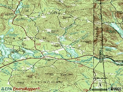
Points of interest:
Notable locations in Freedom: Camp Huckins (A), Four Corners (B), Camp Cody (C), Cragged Mountain Farm (D), Freedom Fire Rescue Department (E). Display/hide their locations on the map
Churches in Freedom include: Unitarian Universalist Church (A), First Christian Church (B). Display/hide their locations on the map
Cemeteries: Lakeview Cemetery (1), Sargent Cemetery (2). Display/hide their locations on the map
Lakes and reservoirs: Danforth Ponds (A), Duck Pond (B), Loon Lake (C), Ossipee Lake (D), Shaw Pond (E), Trout Pond (F), Berry Bay (G). Display/hide their locations on the map
Streams, rivers, and creeks: Stony Brook (A), Square Brook (B), Shawtown Brook (C), Nason Brook (D), Moulton Brook (E), Lovering Brook (F), Blaisdell Brook (G), Bennett Brook (H). Display/hide their locations on the map
Park in Freedom: Lords Hill Historic District (1). Display/hide its location on the map
Drinking water stations with addresses in Freedom and their reported violations in the past:
OSSIPEE MOUNTAINS ESTATES (Population served: 255, Groundwater):Past monitoring violations:PINE LANDING CONDOS (Population served: 50, Groundwater):
- 3 routine major monitoring violations
- 21 regular monitoring violations
Past health violations:Past monitoring violations:
- OCCT/SOWT Study/Recommendation - In JUL-01-2007, Contaminant: Lead and Copper Rule. Follow-up actions: St Violation/Reminder Notice (OCT-08-2007), St Formal NOV issued (NOV-14-2007), St Compliance achieved (MAY-08-2008)
- Water Quality Parameter M/R - In JAN-01-2007, Contaminant: Lead and Copper Rule. Follow-up actions: St Public Notif requested (MAY-22-2007), St Violation/Reminder Notice (MAY-22-2007), St Compliance achieved (AUG-08-2007), St Public Notif received (OCT-17-2007)
Drinking water stations with addresses in Freedom that have no violations reported:
- FREEDOM VILLAGE WATER PRECINCT (Population served: 163, Primary Water Source Type: Groundwater)
| This town: | 2.1 people |
| New Hampshire: | 2.5 people |
| This town: | 65.4% |
| Whole state: | 66.3% |
| This town: | 5.4% |
| Whole state: | 8.3% |
Likely homosexual households (counted as self-reported same-sex unmarried-partner households)
- Lesbian couples: 0.4% of all households
- Gay men: 0.0% of all households
| This town: | 6.8% |
| Whole state: | 6.5% |
| This town: | 4.0% |
| Whole state: | 2.8% |
5 people in residential treatment centers for adults in 2010
6 people in other noninstitutional group quarters in 2000
For population 15 years and over in Freedom:

- Never married: 15.4%
- Now married: 66.3%
- Separated: 0.3%
- Widowed: 7.8%
- Divorced: 10.3%
For population 25 years and over in Freedom:
- High school or higher: 92.1%
- Bachelor's degree or higher: 31.2%
- Graduate or professional degree: 12.0%
- Unemployed: 3.7%
- Mean travel time to work (commute): 32.8 minutes


| Here: | 10.5 |
| New Hampshire average: | 10.9 |
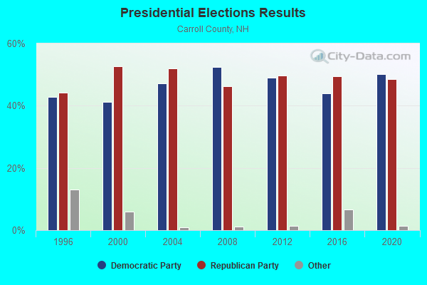
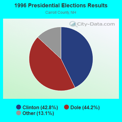
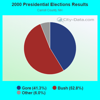

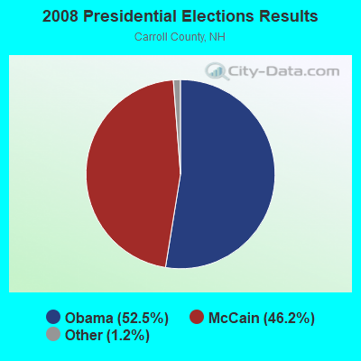
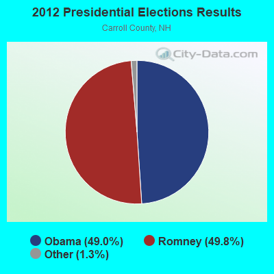
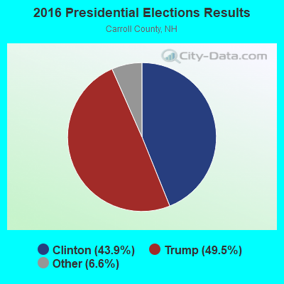
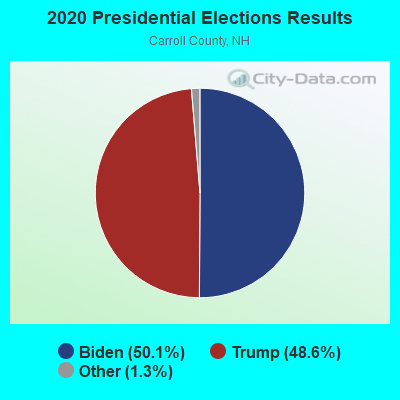
Graphs represent county-level data. Detailed 2008 Election Results
Religion statistics for Freedom, NH (based on Carroll County data)
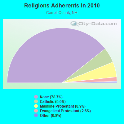
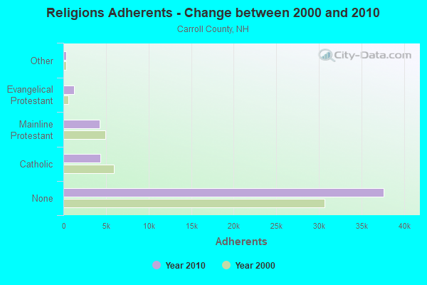
| Religion | Adherents | Congregations |
|---|---|---|
| Catholic | 4,304 | 2 |
| Mainline Protestant | 4,266 | 30 |
| Evangelical Protestant | 1,241 | 14 |
| Other | 366 | 5 |
| None | 37,641 | - |
Food Environment Statistics:
| Carroll County: | 4.23 / 10,000 pop. |
| New Hampshire: | 2.14 / 10,000 pop. |
| Carroll County: | 2.54 / 10,000 pop. |
| New Hampshire: | 1.78 / 10,000 pop. |
| Here: | 8.47 / 10,000 pop. |
| State: | 4.02 / 10,000 pop. |
| This county: | 24.13 / 10,000 pop. |
| New Hampshire: | 9.70 / 10,000 pop. |
| Carroll County: | 8.8% |
| New Hampshire: | 7.6% |
| Carroll County: | 21.2% |
| New Hampshire: | 24.4% |
| This county: | 16.9% |
| New Hampshire: | 15.9% |
Businesses in Freedom, NH
- YMCA: 1
Strongest AM radio stations in Freedom:
- WASR (1420 AM; 5 kW; WOLFEBORO, NH; Owner: RADIO WOLFEBORO, INC.)
- WMTW (870 AM; 10 kW; GORHAM, ME; Owner: RADIO PARTNERS OF MAINE, L.P.)
- WRKO (680 AM; 50 kW; BOSTON, MA; Owner: ENTERCOM BOSTON LICENSE, LLC)
- WGIN (930 AM; 10 kW; ROCHESTER, NH; Owner: CAPSTAR TX LIMITED PARTNERSHIP)
- WBNC (1050 AM; 1 kW; CONWAY, NH; Owner: MT. WASHINGTON RADIO & GRAMOPHONE, L.L.C.)
- WGAN (560 AM; 5 kW; PORTLAND, ME; Owner: SAGA COMMUNICATIONS OF NEW ENGLAND, LLC)
- WEEI (850 AM; 50 kW; BOSTON, MA; Owner: ENTERCOM BOSTON LICENSE, LLC)
- WCRN (830 AM; 50 kW; WORCESTER, MA; Owner: CARTER BROADCASTING CORPORATION)
- WBZ (1030 AM; 50 kW; BOSTON, MA; Owner: INFINITY BROADCASTING OPERATIONS, INC.)
- WEZS (1350 AM; 5 kW; LACONIA, NH; Owner: GARY W. HAMMOND)
- WPNH (1300 AM; 5 kW; PLYMOUTH, NH; Owner: NORTHEAST COMMUNICATIONS CORPORATION)
- WTME (780 AM; 10 kW; RUMFORD, ME; Owner: MOUNTAIN VALLEY BROADCASTING, INC.)
- WNNZ (640 AM; 50 kW; WESTFIELD, MA; Owner: CLEAR CHANNEL BROADCASTING LICENSES, INC.)
Strongest FM radio stations in Freedom:
- WSCY (106.9 FM; MOULTONBOROUGH, NH; Owner: NORTHEAST COMMUNICATIONS CORPORATION)
- WMEA (90.1 FM; PORTLAND, ME; Owner: MAINE PUBLIC BROADCASTING CORPORATION)
- WPKQ (103.7 FM; NORTH CONWAY, NH; Owner: CITADEL BROADCASTING COMPANY)
- WHOM (94.9 FM; MT. WASHINGTON, NH; Owner: CITADEL BROADCASTING COMPANY)
- WVFM (105.7 FM; CAMPTON, NH; Owner: DEVON BROADCASTING COMPANY, INC.)
- WVMJ (104.5 FM; CONWAY, NH; Owner: MT. WASHINGTON RADIO & GRAMOPHONE, L.L.C.)
- WMWV (93.5 FM; CONWAY, NH; Owner: MT. WASHINGTON RADIO & GRAMOPHONE, L.L.C.)
- WLKZ (104.9 FM; WOLFEBORO, NH; Owner: TELE-MEDIA COMPANY OF NEW HAMPSHIRE, L.L.C.)
- WBLM (102.9 FM; PORTLAND, ME; Owner: CITADEL BROADCASTING COMPANY)
- WPNH-FM (100.1 FM; PLYMOUTH, NH; Owner: NORTHEAST COMMUNICATIONS CORPORATION)
- WMEX (106.5 FM; FARMINGTON, NH; Owner: WIMMEX, LLC)
- WNHI (93.3 FM; BELMONT, NH; Owner: CONCORD BROADCASTING, L.L.C.)
- WJBQ (97.9 FM; PORTLAND, ME; Owner: CITADEL BROADCASTING COMPANY)
- WMTK (106.3 FM; LITTLETON, NH; Owner: VERMONT BROADCAST ASSOCIATES, INC.)
- WTHT (107.5 FM; LEWISTON, ME; Owner: RADIO PARTNERS OF MAINE, L.P.)
- WPHX-FM (92.1 FM; SANFORD, ME; Owner: FNX BROADCASTING LLC)
- WSEW (88.5 FM; SANFORD, ME; Owner: WORD RADIO EDUCATIONAL FOUNDATION)
- WLNH-FM (98.3 FM; LACONIA, NH; Owner: WLNH RADIO, INC)
TV broadcast stations around Freedom:
- WMTW-TV (Channel 8; POLAND SPRING, ME; Owner: WMTW BROADCAST GROUP, LLC)
- WCSH (Channel 6; PORTLAND, ME; Owner: PACIFIC AND SOUTHERN COMPANY, INC.)
- WMEA-TV (Channel 26; BIDDEFORD, ME; Owner: MAINE PUBLIC BROADCASTING CORP.)
- WGME-TV (Channel 13; PORTLAND, ME; Owner: WGME LICENSEE, LLC)
Freedom fatal accident list:
Jul 20, 2016 10:56 PM, Sr-153, Lat: 43.828522, Lon: -71.075994, Vehicles: 2, Persons: 2, Fatalities: 1, Drunk persons involved: 1
Jul 17, 2005 00:15 AM, Huckins Rd, Kenison Rd, Lat: 43.811110, Lon: -71.111400, Vehicles: 1, Persons: 1, Fatalities: 1, Drunk persons involved: 1
Jun 12, 2002 04:25 PM, Ossipee Lake Road, Vehicles: 2, Persons: 4, Fatalities: 1, Drunk persons involved: 1
Jun 28, 1997 11:45 PM, 25, Vehicles: 1, Persons: 4, Fatalities: 1, Drunk persons involved: 1
Jan 28, 1989 10:05 PM, 30854, Vehicles: 1, Persons: 1, Fatalities: 1
Sep 26, 1987 08:35 AM, 3084100000, Vehicles: 1, Persons: 1, Fatalities: 1
- National Bridge Inventory (NBI) Statistics
- 3Number of bridges
- 7ft / 2.2mTotal length
- $9,426,000Total costs
- 4,783Total average daily traffic
- 396Total average daily truck traffic
- 7,077Total future (year 2042) average daily traffic
FCC Registered Broadcast Land Mobile Towers:
1- 9 Cody Road (Lat: 43.813056 Lon: -71.144722), Type: Building, Structure height: 9 m, Call Sign: WRQV525,
Assigned Frequencies: 462.825 MHz, Grant Date: 05/12/2022, Expiration Date: 05/12/2032, Certifier: Philip Ross, Registrant: Visiplex, 1287 Barclay Boulevard, Buffalo Grove, IL 60089, Phone: (847) 229-0250, Email:
FCC Registered Amateur Radio Licenses:
15 (See the full list of FCC Registered Amateur Radio Licenses in Freedom)FAA Registered Aircraft:
1- Aircraft: CESSNA 182P (Category: Land, Seats: 4, Weight: Up to 12,499 Pounds, Speed: 120 mph), Engine: CONT MOTOR O-470 SERIES (230 HP) (Reciprocating)
N-Number: 4725K, N4725K, N-4725K, Serial Number: 18263724, Year manufactured: 1975, Airworthiness Date: 03/21/1975, Certificate Issue Date: 01/12/2007
Registrant (Individual): Michael E Dewitt, 74 Pauli Point Rd, Freedom, NH 03836
2004 - 2018 National Fire Incident Reporting System (NFIRS) incidents
- Fire incident types reported to NFIRS in Freedom, NH
- 7258.1%Structure Fires
- 2822.6%Outside Fires
- 2116.9%Mobile Property/Vehicle Fires
- 32.4%Other
 According to the data from the years 2004 - 2018 the average number of fires per year is 8. The highest number of fires - 16 took place in 2015, and the least - 2 in 2006. The data has a growing trend.
 When looking into fire subcategories, the most reports belonged to: Structure Fires (58.1%), and Outside Fires (22.6%).
- 73.2%Fuel oil, kerosene, etc.
- 11.8%Bottled, tank, or LP gas
- 9.6%Wood
- 5.1%Electricity
- 0.4%Utility gas

- 61.8%Fuel oil, kerosene, etc.
- 19.1%Bottled, tank, or LP gas
- 11.8%Wood
- 7.4%Electricity
Freedom compared to New Hampshire state average:
- Unemployed percentage significantly below state average.
- Black race population percentage significantly below state average.
- Hispanic race population percentage significantly below state average.
- Median age significantly above state average.
- Foreign-born population percentage significantly below state average.
- Renting percentage below state average.
- Length of stay since moving in significantly above state average.
- Number of rooms per house significantly below state average.
- House age significantly below state average.

|
Total of 3 patent applications in 2008-2024.