Effingham, New Hampshire
Submit your own pictures of this town and show them to the world
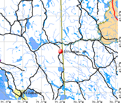
- OSM Map
- General Map
- Google Map
- MSN Map
Population change since 2000: +15.1%
 |
| Males: 728 | |
| Females: 737 |
| Median resident age: | 45.6 years |
| New Hampshire median age: | 43.9 years |
Zip codes: 03814.
| Effingham: | $68,710 |
| NH: | $89,992 |
Estimated per capita income in 2022: $38,360 (it was $17,089 in 2000)
Effingham town income, earnings, and wages data
Estimated median house or condo value in 2022: $278,402 (it was $91,000 in 2000)
| Effingham: | $278,402 |
| NH: | $384,700 |
Mean prices in 2022: all housing units: $505,201; detached houses: $542,950; townhouses or other attached units: $363,532; in 2-unit structures: $373,773; in 3-to-4-unit structures: $587,160; in 5-or-more-unit structures: $313,992; mobile homes: $113,714; occupied boats, rvs, vans, etc.: $118,400
Detailed information about poverty and poor residents in Effingham, NH
Compare current foreclosures near Effingham, NH:
| Photo | Address | Area | Beds / Baths | Price | Details |
|---|---|---|---|---|---|

|
#1
Governor Wentworth Hwy
Moultonborough, NH 03254
|
1,510 sq. feet
|
1 baths 3 beds |
show details | |

|
#2
Old Woods Rd
Center Tuftonboro, NH 03816
|
802 sq. feet
|
1 baths 3 beds |
show details | |

|
#3
Henry Cotton Rd
Center Conway, NH 03813
|
1,792 sq. feet
|
2 baths 3 beds |
show details | |

|
#4
Benjamin Dr
Ossipee, NH 03864
|
- sq. feet
|
- baths - beds |
show details | |

|
#5
Stoneham Rd
Sanbornville, NH 03872
|
- sq. feet
|
- baths - beds |
show details | |

|
#6
Ossipee Lake Rd
Tamworth, NH 03886
|
- sq. feet
|
- baths - beds |
show details | |

|
#7
Pleasant St
Conway, NH 03818
|
- sq. feet
|
- baths - beds |
show details | |

|
#8
Ross Corner Rd
Shapleigh, ME 04076
|
- sq. feet
|
- baths - beds |
show details | |

|
#9
Old Colony Rd
Conway, NH 03818
|
- sq. feet
|
- baths - beds |
show details | |

|
#10
Glendon St
Wolfeboro, NH 03894
|
- sq. feet
|
- baths - beds |
show details |
| Photo | Address | Area | Beds / Baths | Price | Details |
|---|---|---|---|---|---|

|
#11
Cape Rd
Limington, ME 04049
|
- sq. feet
|
- baths - beds |
show details | |

|
#12
N Main St
Wolfeboro, NH 03894
|
- sq. feet
|
- baths - beds |
show details | |

|
#13
Sokokis Ave
Limington, ME 04049
|
- sq. feet
|
- baths - beds |
show details | |

|
#14
Clark Rd
Wolfeboro, NH 03894
|
- sq. feet
|
- baths - beds |
show details | |

|
#15
Tall Pines Ln
Parsonsfield, ME 04047
|
- sq. feet
|
- baths - beds |
show details | |

|
#16
Heath Rd
Sanbornville, NH 03872
|
- sq. feet
|
- baths - beds |
show details | |

|
#17
Pond Rd
Sanbornville, NH 03872
|
- sq. feet
|
- baths - beds |
show details | |

|
#18
Center St
Wolfeboro, NH 03894
|
- sq. feet
|
- baths - beds |
show details | |

|
#19
Elm St
Limerick, ME 04048
|
- sq. feet
|
- baths - beds |
show details | |

|
#20
New Dam Rd
North Waterboro, ME 04061
|
- sq. feet
|
- baths - beds |
show details |
| Photo | Address | Area | Beds / Baths | Price | Details |
|---|---|---|---|---|---|

|
Check over 1 million property listings on Foreclosure.com!
|
browse all offers | |||
| Photo | Address | Area | Beds / Baths | Price | Details |
|---|

- 1,41696.7%White alone
- 191.3%Hispanic
- 181.2%Two or more races
- 40.3%American Indian alone
- 40.3%Asian alone
- 30.2%Black alone
- 10.07%Other race alone

Races in Effingham detailed stats: ancestries, foreign born residents, place of birth
According to our research of New Hampshire and other state lists, there were 7 registered sex offenders living in Effingham, New Hampshire as of May 28, 2024.
The ratio of all residents to sex offenders in Effingham is 209 to 1.
Type |
2011 |
2012 |
2013 |
2014 |
2015 |
2016 |
2017 |
2018 |
2019 |
2020 |
2021 |
2022 |
|---|---|---|---|---|---|---|---|---|---|---|---|---|
| Murders (per 100,000) | 0 (0.0) | 0 (0.0) | 0 (0.0) | 0 (0.0) | 0 (0.0) | 1 (65.2) | 0 (0.0) | 0 (0.0) | 0 (0.0) | 0 (0.0) | 0 (0.0) | 0 (0.0) |
| Rapes (per 100,000) | 0 (0.0) | 0 (0.0) | 0 (0.0) | 3 (192.3) | 1 (64.4) | 1 (65.2) | 0 (0.0) | 1 (68.6) | 1 (67.6) | 0 (0.0) | 0 (0.0) | 0 (0.0) |
| Robberies (per 100,000) | 0 (0.0) | 0 (0.0) | 0 (0.0) | 0 (0.0) | 0 (0.0) | 0 (0.0) | 0 (0.0) | 0 (0.0) | 0 (0.0) | 0 (0.0) | 1 (67.4) | 0 (0.0) |
| Assaults (per 100,000) | 0 (0.0) | 2 (136.7) | 4 (273.8) | 1 (64.1) | 0 (0.0) | 0 (0.0) | 3 (208.5) | 2 (137.2) | 0 (0.0) | 2 (135.2) | 1 (67.4) | 1 (56.1) |
| Burglaries (per 100,000) | 10 (681.7) | 17 (1,162) | 2 (136.9) | 3 (192.3) | 12 (772.2) | 9 (587.1) | 4 (278.0) | 2 (137.2) | 0 (0.0) | 0 (0.0) | 2 (134.9) | 1 (56.1) |
| Thefts (per 100,000) | 16 (1,091) | 21 (1,435) | 14 (958.2) | 18 (1,154) | 14 (900.9) | 17 (1,109) | 9 (625.4) | 8 (548.7) | 1 (67.6) | 5 (338.1) | 3 (202.3) | 2 (112.3) |
| Auto thefts (per 100,000) | 1 (68.2) | 2 (136.7) | 1 (68.4) | 1 (64.1) | 1 (64.4) | 0 (0.0) | 1 (69.5) | 0 (0.0) | 0 (0.0) | 2 (135.2) | 0 (0.0) | 1 (56.1) |
| Arson (per 100,000) | 0 (0.0) | 0 (0.0) | 0 (0.0) | 0 (0.0) | 1 (64.4) | 0 (0.0) | 0 (0.0) | 0 (0.0) | 0 (0.0) | 0 (0.0) | 0 (0.0) | 0 (0.0) |
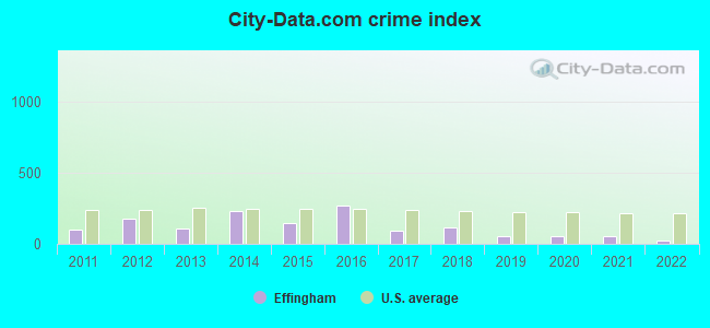
| City-Data.com crime index | 96.8 | 177.0 | 108.1 | 231.4 | 146.7 | 268.1 | 91.7 | 113.9 | 56.8 | 51.4 | 51.2 | 24.1 |
The City-Data.com crime index weighs serious crimes and violent crimes more heavily. Higher means more crime, U.S. average is 246.1. It adjusts for the number of visitors and daily workers commuting into cities.
Crime rate in Effingham detailed stats: murders, rapes, robberies, assaults, burglaries, thefts, arson
Full-time law enforcement employees in 2021, including police officers: 2 (2 officers - 2 male; 0 female).
| Officers per 1,000 residents here: | 1.35 |
| New Hampshire average: | 2.14 |
 Recent articles from our blog. Our writers, many of them Ph.D. graduates or candidates, create easy-to-read articles on a wide variety of topics.

 | Move to NH - Suggested Areas & Towns? (108 replies) |
| Freedom, NH - looking for similar towns? (12 replies) |
| Relocating to rural New England (18 replies) |
| Move to NH from FL, advice/opinions/suggestions wanted! (75 replies) |
| Ossipee (23 replies) |
| Would you move to New Hampshire if you were me? (21 replies) |
Latest news from Effingham, NH collected exclusively by city-data.com from local newspapers, TV, and radio stations
Ancestries: Irish (17.8%), English (17.3%), French (12.5%), German (11.2%), United States (8.6%), Italian (6.4%).
Current Local Time: EST time zone
Incorporated in 1778
Elevation: 610 feet
Land area: 38.5 square miles.
Population density: 38 people per square mile (very low).
18 residents are foreign born
| This town: | 1.4% |
| New Hampshire: | 4.4% |
| Effingham town: | 1.9% ($1,691) |
| New Hampshire: | 2.3% ($2,946) |
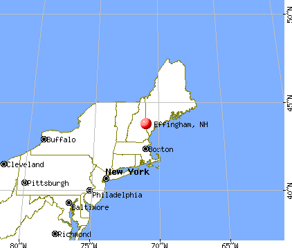
Nearest city with pop. 50,000+: Portland, ME  (38.2 miles , pop. 64,249).
Nearest city with pop. 200,000+: Boston, MA (98.4 miles , pop. 589,141).
Nearest city with pop. 1,000,000+: Bronx, NY (247.7 miles , pop. 1,332,650).
Nearest cities:
), ), ), ), ), Latitude: 43.74 N, Longitude: 71.03 W

Single-family new house construction building permits:
- 2022: 11 buildings, average cost: $277,400
- 2021: 10 buildings, average cost: $259,200
- 2020: 7 buildings, average cost: $248,200
- 2019: 5 buildings, average cost: $282,200
- 2018: 6 buildings, average cost: $249,800
- 2017: 3 buildings, average cost: $248,100
- 2016: 2 buildings, average cost: $246,000
- 2015: 2 buildings, average cost: $226,800
- 2014: 1 building, cost: $193,300
- 2013: 3 buildings, average cost: $193,300
- 2012: 3 buildings, average cost: $172,800
- 2011: 9 buildings, average cost: $172,100
- 2010: 4 buildings, average cost: $165,900
- 2009: 6 buildings, average cost: $179,500
- 2008: 9 buildings, average cost: $182,000
- 2007: 7 buildings, average cost: $181,200
- 2006: 14 buildings, average cost: $171,000
- 2005: 31 buildings, average cost: $150,200
- 2004: 19 buildings, average cost: $138,800


| Here: | 3.2% |
| New Hampshire: | 2.5% |


- Health care (10.2%)
- Construction (9.9%)
- Accommodation & food services (8.3%)
- Social assistance (7.2%)
- Educational services (6.3%)
- Professional, scientific, technical services (4.1%)
- Food & beverage stores (3.9%)

- Construction (16.6%)
- Accommodation & food services (6.8%)
- Motor vehicle & parts dealers (5.2%)
- Repair & maintenance (4.9%)
- Agriculture, forestry, fishing & hunting (4.6%)
- Professional, scientific, technical services (4.6%)
- Food & beverage stores (4.6%)

- Health care (18.6%)
- Social assistance (11.6%)
- Educational services (10.0%)
- Accommodation & food services (10.0%)
- Public administration (5.5%)
- Professional, scientific, technical services (3.5%)
- Food & beverage stores (3.2%)

- Building and grounds cleaning and maintenance occupations (7.4%)
- Electrical equipment mechanics and other installation, maintenance, and repair workers, including supervisors (4.1%)
- Other management occupations, except farmers and farm managers (3.8%)
- Vehicle and mobile equipment mechanics, installers, and repairers (3.6%)
- Driver/sales workers and truck drivers (3.5%)
- Other sales and related occupations, including supervisors (3.0%)
- Retail sales workers, except cashiers (2.7%)

- Building and grounds cleaning and maintenance occupations (8.0%)
- Electrical equipment mechanics and other installation, maintenance, and repair workers, including supervisors (7.4%)
- Vehicle and mobile equipment mechanics, installers, and repairers (7.1%)
- Driver/sales workers and truck drivers (6.5%)
- Other management occupations, except farmers and farm managers (4.9%)
- Material recording, scheduling, dispatching, and distributing workers (4.3%)
- Other sales and related occupations, including supervisors (4.0%)

- Building and grounds cleaning and maintenance occupations (6.8%)
- Registered nurses (5.1%)
- Health technologists and technicians (4.2%)
- Other office and administrative support workers, including supervisors (4.2%)
- Secretaries and administrative assistants (4.2%)
- Other teachers, instructors, education, training, and library occupations (4.2%)
- Nursing, psychiatric, and home health aides (3.9%)
Average climate in Effingham, New Hampshire
Based on data reported by over 4,000 weather stations


(lower is better)

Air Quality Index (AQI) level in 2023 was 48.8. This is significantly better than average.
| City: | 48.8 |
| U.S.: | 72.6 |

Ozone [ppb] level in 2023 was 29.7. This is about average. Closest monitor was 13.0 miles away from the city center.
| City: | 29.7 |
| U.S.: | 33.3 |
Tornado activity:
Effingham-area historical tornado activity is below New Hampshire state average. It is 69% smaller than the overall U.S. average.
On 7/18/1963, a category F2 (max. wind speeds 113-157 mph) tornado 13.2 miles away from the Effingham town center caused between $5000 and $50,000 in damages.
On 6/22/1981, a category F2 tornado 22.9 miles away from the town center caused between $500,000 and $5,000,000 in damages.
Earthquake activity:
Effingham-area historical earthquake activity is significantly above New Hampshire state average. It is 73% smaller than the overall U.S. average.On 4/20/2002 at 10:50:47, a magnitude 5.3 (5.3 ML, Depth: 3.0 mi, Class: Moderate, Intensity: VI - VII) earthquake occurred 142.9 miles away from the city center
On 10/16/2012 at 23:12:25, a magnitude 4.7 (4.7 ML, Depth: 10.0 mi, Class: Light, Intensity: IV - V) earthquake occurred 21.1 miles away from Effingham center
On 1/19/1982 at 00:14:42, a magnitude 4.7 (4.5 MB, 4.7 MD, 4.5 LG) earthquake occurred 33.3 miles away from Effingham center
On 4/20/2002 at 10:50:47, a magnitude 5.2 (5.2 MB, 4.2 MS, 5.2 MW, 5.0 MW) earthquake occurred 143.2 miles away from Effingham center
On 10/7/1983 at 10:18:46, a magnitude 5.3 (5.1 MB, 5.3 LG, 5.1 ML) earthquake occurred 166.0 miles away from the city center
On 8/21/1996 at 07:54:14, a magnitude 3.8 (3.8 LG, 3.6 LG, Depth: 6.2 mi, Class: Light, Intensity: II - III) earthquake occurred 34.5 miles away from Effingham center
Magnitude types: regional Lg-wave magnitude (LG), body-wave magnitude (MB), duration magnitude (MD), local magnitude (ML), surface-wave magnitude (MS), moment magnitude (MW)
Natural disasters:
The number of natural disasters in Carroll County (29) is a lot greater than the US average (15).Major Disasters (Presidential) Declared: 17
Emergencies Declared: 9
Causes of natural disasters: Storms: 12, Floods: 11, Winter Storms: 5, Hurricanes: 4, Snows: 4, Snowstorms: 2, Blizzard: 1, Heavy Rain: 1, Ice Storm: 1, Snowfall: 1, Tornado: 1, Tropical Storm: 1, Wind: 1, Other: 1 (Note: some incidents may be assigned to more than one category).

Hospitals and medical centers near Effingham:
- MOUNTAIN VIEW NURSING HOME (Nursing Home, about 7 miles away; OSSIPEE, NH)
- HUGGINS HOSPITAL Critical Access Hospitals (about 15 miles away; WOLFEBORO, NH)
- VNA HOSPICE OF S CARROLL CO AND VICINITY (Hospital, about 15 miles away; WOLFEBORO, NH)
- WOLFEBORO BAY CARE AND REHABILITATION CENTER (Nursing Home, about 15 miles away; WOLFEBORO, NH)
Colleges/universities with over 2000 students nearest to Effingham:
- Saint Joseph's College of Maine (about 28 miles; Standish, ME; Full-time enrollment: 2,010)
- Plymouth State University (about 34 miles; Plymouth, NH; FT enrollment: 4,838)
- University of New England (about 38 miles; Biddeford, ME; FT enrollment: 4,539)
- University of Southern Maine (about 38 miles; Portland, ME; FT enrollment: 6,647)
- Southern Maine Community College (about 41 miles; South Portland, ME; FT enrollment: 4,666)
- University of New Hampshire-Main Campus (about 43 miles; Durham, NH; FT enrollment: 15,243)
- NHTI-Concord's Community College (about 45 miles; Concord, NH; FT enrollment: 2,865)
Public elementary/middle school in Effingham:
- EFFINGHAM ELEMENTARY SCHOOL (Students: 112, Location: 6 PARTRIDGE COVE RD., Grades: KG-6)
Points of interest:
Notable locations in Effingham: Camp Marist (A), Beachwood Shores Campground (B), Davis Meetinghouse (C), Masonic Temple (D), Effingham Fire Rescue Department (E). Display/hide their locations on the map
Reservoir: Hutchins Pond (A). Display/hide its location on the map
Streams, rivers, and creeks: Salmon Brook (A), Red Pine Brook (B), Wilkinson Brook (C), Peavey Brook (D), Mastin Brook (E), Leavitt Brook (F), Hodgedon Brook (G), Flanders Brook (H). Display/hide their locations on the map
Drinking water stations with addresses in Effingham and their reported violations in the past:
PROVINCE LAKE GOLF ENTRPR INC (Serves ME, Population served: 300, Groundwater):Past monitoring violations:LAKEVIEW NEUROREHAB CTR (Population served: 280, Groundwater):
- 6 routine major monitoring violations
Past health violations:Past monitoring violations:
- MCL, Monthly (TCR) - In OCT-2009, Contaminant: Coliform. Follow-up actions: St Public Notif requested (OCT-29-2009), St Violation/Reminder Notice (OCT-29-2009), St Public Notif received (NOV-18-2009), St Compliance achieved (MAY-25-2010)
- Failure To Address Deficiency - In JUN-02-2013, Contaminant: GROUNDWATER RULE. Follow-up actions: St Public Notif requested (JUN-07-2013), St Violation/Reminder Notice (JUN-07-2013), St Compliance achieved (JUN-28-2013), St Public Notif received (JUN-28-2013)
- Monitoring, Source Water (GWR) - Between OCT-18-2012 and NOV-18-2012, Contaminant: E. COLI. Follow-up actions: St Public Notif requested (DEC-03-2012), St Violation/Reminder Notice (DEC-03-2012), St Compliance achieved (DEC-07-2012), St Public Notif received (JAN-07-2013)
- Monitoring, Repeat Major (TCR) - In OCT-2012, Contaminant: Coliform (TCR). Follow-up actions: St Public Notif requested (DEC-03-2012), St Violation/Reminder Notice (DEC-03-2012), St Compliance achieved (DEC-07-2012), St Public Notif received (JAN-07-2013)
- One routine major monitoring violation
| This town: | 2.4 people |
| New Hampshire: | 2.5 people |
| This town: | 67.0% |
| Whole state: | 66.3% |
| This town: | 9.5% |
| Whole state: | 8.3% |
Likely homosexual households (counted as self-reported same-sex unmarried-partner households)
- Lesbian couples: 0.0% of all households
- Gay men: 0.2% of all households
| This town: | 15.3% |
| Whole state: | 6.5% |
| This town: | 9.7% |
| Whole state: | 2.8% |
For population 15 years and over in Effingham:

- Never married: 24.2%
- Now married: 55.9%
- Separated: 1.4%
- Widowed: 7.3%
- Divorced: 11.3%
For population 25 years and over in Effingham:
- High school or higher: 82.7%
- Bachelor's degree or higher: 17.1%
- Graduate or professional degree: 6.1%
- Unemployed: 9.7%
- Mean travel time to work (commute): 31.4 minutes


| Here: | 11.7 |
| New Hampshire average: | 10.9 |
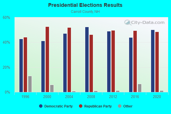
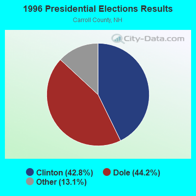
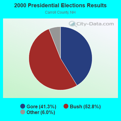

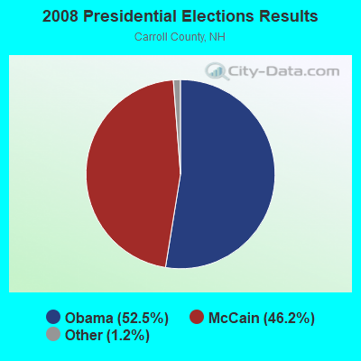
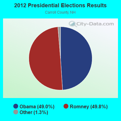
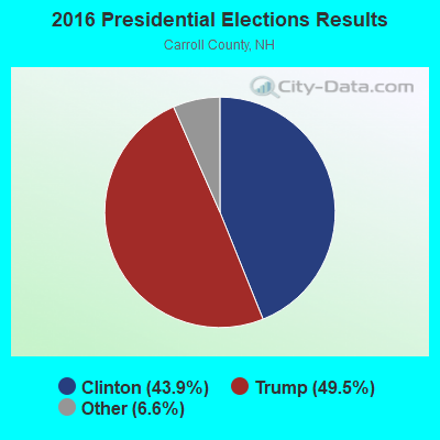
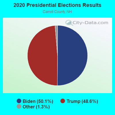
Graphs represent county-level data. Detailed 2008 Election Results
Religion statistics for Effingham, NH (based on Carroll County data)
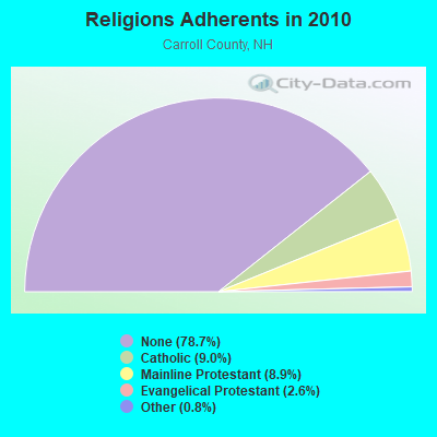
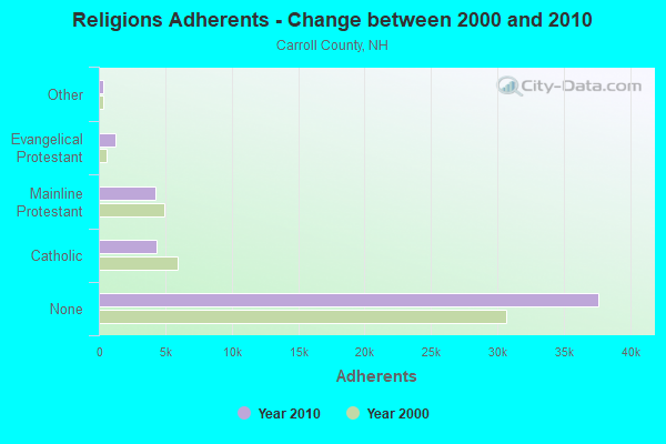
| Religion | Adherents | Congregations |
|---|---|---|
| Catholic | 4,304 | 2 |
| Mainline Protestant | 4,266 | 30 |
| Evangelical Protestant | 1,241 | 14 |
| Other | 366 | 5 |
| None | 37,641 | - |
Food Environment Statistics:
| Carroll County: | 4.23 / 10,000 pop. |
| New Hampshire: | 2.14 / 10,000 pop. |
| This county: | 2.54 / 10,000 pop. |
| New Hampshire: | 1.78 / 10,000 pop. |
| Carroll County: | 8.47 / 10,000 pop. |
| New Hampshire: | 4.02 / 10,000 pop. |
| Here: | 24.13 / 10,000 pop. |
| New Hampshire: | 9.70 / 10,000 pop. |
| Here: | 8.8% |
| New Hampshire: | 7.6% |
| Carroll County: | 21.2% |
| New Hampshire: | 24.4% |
| Carroll County: | 16.9% |
| New Hampshire: | 15.9% |
Strongest AM radio stations in Effingham:
- WASR (1420 AM; 5 kW; WOLFEBORO, NH; Owner: RADIO WOLFEBORO, INC.)
- WMTW (870 AM; 10 kW; GORHAM, ME; Owner: RADIO PARTNERS OF MAINE, L.P.)
- WGIN (930 AM; 10 kW; ROCHESTER, NH; Owner: CAPSTAR TX LIMITED PARTNERSHIP)
- WRKO (680 AM; 50 kW; BOSTON, MA; Owner: ENTERCOM BOSTON LICENSE, LLC)
- WGAN (560 AM; 5 kW; PORTLAND, ME; Owner: SAGA COMMUNICATIONS OF NEW ENGLAND, LLC)
- WEEI (850 AM; 50 kW; BOSTON, MA; Owner: ENTERCOM BOSTON LICENSE, LLC)
- WBZ (1030 AM; 50 kW; BOSTON, MA; Owner: INFINITY BROADCASTING OPERATIONS, INC.)
- WCRN (830 AM; 50 kW; WORCESTER, MA; Owner: CARTER BROADCASTING CORPORATION)
- WEZS (1350 AM; 5 kW; LACONIA, NH; Owner: GARY W. HAMMOND)
- WKOX (1200 AM; 50 kW; FRAMINGHAM, MA; Owner: CAPSTAR TX LIMITED PARTNERSHIP)
- WZAN (970 AM; 5 kW; PORTLAND, ME; Owner: SAGA COMMUNICATIONS OF NEW ENGLAND, LLC)
- WNNZ (640 AM; 50 kW; WESTFIELD, MA; Owner: CLEAR CHANNEL BROADCASTING LICENSES, INC.)
- WWZN (1510 AM; 50 kW; BOSTON, MA; Owner: ROSE CITY RADIO CORPORATION)
Strongest FM radio stations in Effingham:
- WSCY (106.9 FM; MOULTONBOROUGH, NH; Owner: NORTHEAST COMMUNICATIONS CORPORATION)
- WMEA (90.1 FM; PORTLAND, ME; Owner: MAINE PUBLIC BROADCASTING CORPORATION)
- WPKQ (103.7 FM; NORTH CONWAY, NH; Owner: CITADEL BROADCASTING COMPANY)
- WHOM (94.9 FM; MT. WASHINGTON, NH; Owner: CITADEL BROADCASTING COMPANY)
- WVFM (105.7 FM; CAMPTON, NH; Owner: DEVON BROADCASTING COMPANY, INC.)
- WLKZ (104.9 FM; WOLFEBORO, NH; Owner: TELE-MEDIA COMPANY OF NEW HAMPSHIRE, L.L.C.)
- WBLM (102.9 FM; PORTLAND, ME; Owner: CITADEL BROADCASTING COMPANY)
- WVMJ (104.5 FM; CONWAY, NH; Owner: MT. WASHINGTON RADIO & GRAMOPHONE, L.L.C.)
- WMWV (93.5 FM; CONWAY, NH; Owner: MT. WASHINGTON RADIO & GRAMOPHONE, L.L.C.)
- WMEX (106.5 FM; FARMINGTON, NH; Owner: WIMMEX, LLC)
- WPNH-FM (100.1 FM; PLYMOUTH, NH; Owner: NORTHEAST COMMUNICATIONS CORPORATION)
- WNHI (93.3 FM; BELMONT, NH; Owner: CONCORD BROADCASTING, L.L.C.)
- WPHX-FM (92.1 FM; SANFORD, ME; Owner: FNX BROADCASTING LLC)
- WSEW (88.5 FM; SANFORD, ME; Owner: WORD RADIO EDUCATIONAL FOUNDATION)
- WJBQ (97.9 FM; PORTLAND, ME; Owner: CITADEL BROADCASTING COMPANY)
- WTHT (107.5 FM; LEWISTON, ME; Owner: RADIO PARTNERS OF MAINE, L.P.)
- WLNH-FM (98.3 FM; LACONIA, NH; Owner: WLNH RADIO, INC)
TV broadcast stations around Effingham:
- WMTW-TV (Channel 8; POLAND SPRING, ME; Owner: WMTW BROADCAST GROUP, LLC)
- WCSH (Channel 6; PORTLAND, ME; Owner: PACIFIC AND SOUTHERN COMPANY, INC.)
- WMEA-TV (Channel 26; BIDDEFORD, ME; Owner: MAINE PUBLIC BROADCASTING CORP.)
- WGME-TV (Channel 13; PORTLAND, ME; Owner: WGME LICENSEE, LLC)
- WPXT (Channel 51; PORTLAND, ME; Owner: HMW, INC.)
- WPME (Channel 35; LEWISTON, ME; Owner: KB PRIME MEDIA LLC)
- National Bridge Inventory (NBI) Statistics
- 7Number of bridges
- 108ft / 32.9mTotal length
- $21,994,000Total costs
- 6,932Total average daily traffic
- 713Total average daily truck traffic
- 10,255Total future (year 2042) average daily traffic
FCC Registered Amateur Radio Licenses:
11 (See the full list of FCC Registered Amateur Radio Licenses in Effingham)FAA Registered Aircraft:
2- Aircraft: TAYLORCRAFT DCO-65 (Category: Land, Seats: 2, Weight: Up to 12,499 Pounds, Speed: 82 mph), Engine: Reciprocating
N-Number: 8347, N8347, N-8347, Serial Number: L5297, Certificate Issue Date: 01/23/2004
Registrant (Individual): Christopher S Kanca, 53 Woodland Rd, Effingham, NH 03882 - Aircraft: ENGINEERING & RESEARCH ERCOUPE 415-C (Category: Land, Seats: 2, Weight: Up to 12,499 Pounds, Speed: 90 mph), Engine: CONT MOTOR C85 SERIES (85 HP) (Reciprocating)
N-Number: 99835, N99835, N-99835, Serial Number: 2458, Year manufactured: 1946, Airworthiness Date: 06/28/1956, Certificate Issue Date: 02/22/2017
Registrant (Co-Owned): Stanley P Drelick, 183 Pine River Path, Effingham, NH 03882, Other Owners: Jeremy J Drelick
2002 - 2018 National Fire Incident Reporting System (NFIRS) incidents
- Fire incident types reported to NFIRS in Effingham, NH
- 9055.9%Structure Fires
- 3119.3%Outside Fires
- 2314.3%Other
- 1710.6%Mobile Property/Vehicle Fires
 Based on the data from the years 2002 - 2018 the average number of fire incidents per year is 9. The highest number of fires - 22 took place in 2014, and the least - 1 in 2002. The data has an increasing trend.
 When looking into fire subcategories, the most reports belonged to: Structure Fires (55.9%), and Outside Fires (19.3%).
- 71.2%Fuel oil, kerosene, etc.
- 16.3%Wood
- 11.2%Bottled, tank, or LP gas
- 0.8%Electricity
- 0.5%Utility gas

- 77.6%Fuel oil, kerosene, etc.
- 8.2%Bottled, tank, or LP gas
- 8.2%Wood
- 4.1%Electricity
- 2.0%Utility gas
Effingham compared to New Hampshire state average:
- Black race population percentage significantly below state average.
- Hispanic race population percentage significantly below state average.
- Foreign-born population percentage significantly below state average.
- Renting percentage below state average.
- Length of stay since moving in significantly above state average.
- Number of rooms per house significantly below state average.
- House age significantly below state average.
- Percentage of population with a bachelor's degree or higher below state average.
Effingham on our top lists:
- #14 on the list of "Top 101 cities with the largest percentage of people in other noninstitutional group quarters (population 1,000+)"

|
Total of 1 patent application in 2008-2024.