Bridge Statistics for West Palm Beach, Florida (FL)
Condition, Traffic, Stress, Structural Evaluation, Project Costs
- National Bridge Inventory (NBI) Statistics
- 121Number of bridges
- 2,966ft / 904mTotal length
- $62,349,000Total costs
- 5,262,337Total average daily traffic
- 427,624Total average daily truck traffic
- National Bridge Inventory (NBI) Registered Bridges for West Palm Beach
- No street view available for this location
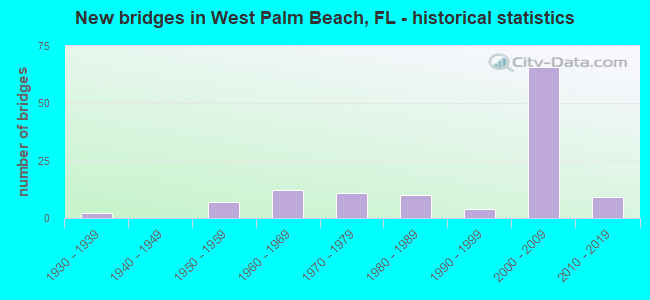
- New bridges - historical statistics
- 21930-1939
- 71950-1959
- 121960-1969
- 111970-1979
- 101980-1989
- 41990-1999
- 662000-2009
- 92010-2019

- Reconstructed bridges - Historical Statistics
- 21970-1979
- 31980-1989
- 41990-1999
- 32000-2009


- Bridge Condition - Deck
- 1.4%Excellent
- 21.1%Very good
- 67.6%Good
- 5.6%Satisfactory
- 2.8%Fair
- 1.4%Poor

- Bridge Condition - Superstructure
- 1.4%Excellent
- 32.4%Very good
- 52.1%Good
- 8.5%Satisfactory
- 4.2%Fair
- 1.4%Poor

- Bridge Condition - Substructure
- 1.4%Excellent
- 26.8%Very good
- 69.0%Good
- 2.8%Satisfactory

- Bridge Condition - Channel
- 8.9%Excellent
- 28.9%Very good
- 51.1%Good
- 11.1%Satisfactory

- Bridge Condition - Culverts
- 50.0%Very good
- 50.0%Good
Find on map >> Show street view
Structure Number: 930053, Location: .25m W of US-1 on US-98 (Lat: 26.675756, Lng: -80.059994), Route carried "on" structure: US 98, Year Built: 1939, Year Reconstructed: 1979, Status: Open, Structure Length: 35.71m (117.16ft), Average Daily Traffic: 31,000 (year 2021), Truck Traffic: 6%, Average Future Daily Traffic: 53,785 (year 2042), Design Load: H 20, Features Intersected: FEC RR & Georgia Ave.
Minimum Vertical Clearance: 30+ m (98+ ft), Kilometerpoint: 33.062, Lanes on structure: 4, Lanes under structure: 6, Base Highway Network: Yes, Owner: State Highway Agency, Approaching Roadway Width: 18.1m (59.4ft), Material/Design: Steel, Design/Construction: Stringer/Multi-beam, Number Of Spans In Main Unit: 1, Number Of Approach Spans: 36, Length of Maximum Span: 18.3m (60.0ft), Curb or Sidewalk Widths: Left: 1.5m (4.9ft), Right: 1.5m (4.9ft), Curb-To-Curb Width: 15.5m (50.9ft), Out-to-Out Width: 19.3m (63.3ft)
Condition: Deck: Good, Superstructure: Fair, Substructure: Good, Operating Rating: 50.2 metric tons, Method Used To Determine Operating Rating: Load Factor (LF), Inventory Rating: 30.1 metric tons, Method Used To Determine Inventory Rating: Load Factor (LF), Structural Evaluation: Somewhat better than minimum adequacy, Deck Geometry: Meets minimum limits, Underclear: High priority of corrective action, Approach Roadway Alignment: Equal to present desirable criteria, Designated Inspection Frequency: Every 24 months, Inspection Date: July 2021, Deck Structure Type: Concrete Cast-file-Place, Wearing Surface/Protective System: Wearing Surface: Bituminous
Find on map >> Show street view
Structure Number: 930097, Location: .5MI W of A1A & E of SR-5 (Lat: 26.675447, Lng: -80.048397), Route carried "on" structure: State highway 80, Year Built: 2018, Status: Temporarily open, Structure Length: 32.03m (105.09ft), Average Daily Traffic: 10,900 (year 2018), Truck Traffic: 4%, Average Future Daily Traffic: 18,912 (year 2040), Design Load: HL 93, Features Intersected: Intracoastal Waterway, Facility Carried by Structure: Southern Boulevard
Minimum Vertical Clearance: 5.18m (16.99ft), Kilometerpoint: 34.221, Lanes on structure: 2, Owner: Private, Approaching Roadway Width: 9.1m (29.9ft), Navigation Control: Yes ( Vertical Clearance: 4.3m (14.1ft), Horizontal Clearance: 38.1m (125.0ft)), Material/Design: Steel, Design/Construction: Movable - Lift, Number Of Spans In Main Unit: 1, Number Of Approach Spans: 20, Length of Maximum Span: 51.7m (169.6ft), Curb or Sidewalk Widths: Left: 1.5m (4.9ft), Right: 0.0m, Curb-To-Curb Width: 9.1m (29.9ft), Out-to-Out Width: 12.6m (41.3ft)
Condition: Deck: Very good, Superstructure: Good, Substructure: Good, Channel: Excellent, Structural Evaluation: High priority of replacement, Deck Geometry: Meets minimum limits, Waterway Adequacy: Superior to present desirable criteria, Approach Roadway Alignment: Equal to present minimum criteria, Length Of Structure Improvement: 28.90m (94.82ft), Designated Inspection Frequency: Every 23 months, Critical Feature Inspection Frequency: Every 23 months, Underwater Inspection Frequency: Every 23 months, Other Special Inspection Frequency: Every 11 months, Inspection Date: January 2022, Critical Feature Inspection Date: January 2022, Underwater Inspection Date: January 2022, Other Special Inspection Date: January 2022, Bridge Improvement Cost: $23,224,000, Roadway Improvement Cost: $13,674,000, Total Project Cost: $62,299,000, Deck Structure Type: Concrete Precast Panels
Find on map >> Show street view
Structure Number: 930142, Location: WEST PALM BEACH INTERCH. (Lat: 26.710983, Lng: -80.138767), Route carried "on" structure: Ramp State highway 91, Year Built: 1956, Status: Open, Structure Length: 5.15m (16.90ft), Average Daily Traffic: 3,600 (year 2021), Truck Traffic: 16%, Average Future Daily Traffic: 6,246 (year 2042), Design Load: HS 20+Mod, Features Intersected: SR 91 TPK(OKEECH BV INT)
Minimum Vertical Clearance: 30+ m (98+ ft), Kilometerpoint: 0.447, Lanes on structure: 2, Lanes under structure: 5, Toll: On toll road, Owner: State Toll Authority, Approaching Roadway Width: 11.6m (38.1ft), Skew: 30 degrees, Material/Design: Steel, Design/Construction: Stringer/Multi-beam, Number Of Spans In Main Unit: 4, Length of Maximum Span: 17.8m (58.4ft), Curb-To-Curb Width: 11.0m (36.1ft), Out-to-Out Width: 12.5m (41.0ft)
Condition: Deck: Satisfactory, Superstructure: Satisfactory, Substructure: Good, Operating Rating: 40.1 metric tons, Method Used To Determine Operating Rating: Load and Resistance Factor (LRFR), Inventory Rating: 30.8 metric tons, Method Used To Determine Inventory Rating: Load and Resistance Factor (LRFR), Structural Evaluation: Equal to present minimum criteria, Deck Geometry: Better than present minimum criteria, Underclear: High priority of corrective action, Approach Roadway Alignment: Better than present minimum criteria, Length Of Structure Improvement: 5.18m (16.99ft), Designated Inspection Frequency: Every 24 months, Inspection Date: November 2021, Bridge Improvement Cost: $50,000, Total Project Cost: $50,000, Deck Structure Type: Concrete Cast-file-Place
Find on map >> Show street view
Structure Number: 930183, Location: .7mi. E of Congress Ave. (Lat: 26.706175, Lng: -80.075242), Route carried "on" structure: State highway 704, Year Built: 1966, Year Reconstructed: 2001, Status: Open, Structure Length: 9.75m (31.99ft), Average Daily Traffic: 29,250 (year 2020), Truck Traffic: 5%, Average Future Daily Traffic: 50,749 (year 2042), Design Load: HS 20, Features Intersected: I-95 (SR-9)
Minimum Vertical Clearance: 30+ m (98+ ft), Kilometerpoint: 12.397, Lanes on structure: 4, Lanes under structure: 11, Base Highway Network: Yes, Owner: State Highway Agency, Approaching Roadway Width: 16.5m (54.1ft), Skew: 3 degrees, Material/Design: Prestressed concrete, Design/Construction: Stringer/Multi-beam, Number Of Spans In Main Unit: 4, Length of Maximum Span: 34.4m (112.9ft), Curb or Sidewalk Widths: Left: 2.6m (8.5ft), Right: 0.0m, Curb-To-Curb Width: 20.5m (67.3ft), Out-to-Out Width: 22.3m (73.2ft)
Condition: Deck: Very good, Superstructure: Good, Substructure: Good, Operating Rating: 80.5 metric tons, Method Used To Determine Operating Rating: Load Factor (LF), Inventory Rating: 48.3 metric tons, Method Used To Determine Inventory Rating: Load Factor (LF), Structural Evaluation: Better than present minimum criteria, Deck Geometry: Superior to present desirable criteria, Underclear: Meets minimum limits, Approach Roadway Alignment: Equal to present desirable criteria, Designated Inspection Frequency: Every 24 months, Inspection Date: June 2021, Deck Structure Type: Concrete Cast-file-Place
Find on map >> Show street view
Structure Number: 93019, Location: 800 ft. S of SR 704 Exit (Lat: 26.700278, Lng: -80.071819), Route carried "on" structure: Interstate 95, Year Built: 1974, Year Reconstructed: 2001, Status: Open, Structure Length: 0.70m (2.30ft), Average Daily Traffic: 247,000 (year 2018), Truck Traffic: 8%, Average Future Daily Traffic: 428,545 (year 2040), Design Load: HS 20, Features Intersected: Drainage Canal
Minimum Vertical Clearance: 30+ m (98+ ft), Kilometerpoint: 43.407, Lanes on structure: 12, Base Highway Network: Yes, Owner: State Highway Agency, Approaching Roadway Width: 39.8m (130.6ft), Skew: 30 degrees, Material/Design: Concrete, Design/Construction: Culvert, Number Of Spans In Main Unit: 3, Length of Maximum Span: 2.1m (6.9ft)
Condition: Channel: Good, Culverts: Good, Operating Rating: 76.3 metric tons, Method Used To Determine Operating Rating: Load Factor (LF), Inventory Rating: 45.8 metric tons, Method Used To Determine Inventory Rating: Load Factor (LF), Structural Evaluation: Better than present minimum criteria, Waterway Adequacy: Equal to present desirable criteria, Approach Roadway Alignment: Equal to present desirable criteria, Designated Inspection Frequency: Every 24 months, Underwater Inspection Frequency: Every 24 months, Inspection Date: Febuary 2021, Underwater Inspection Date: Febuary 2021
Find on map >> Show street view
Structure Number: 93021, Location: .7mi. E of Congress Ave. (Lat: 26.705933, Lng: -80.076083), Route carried "on" structure: State highway 704, Year Built: 1966, Year Reconstructed: 2001, Status: Open, Structure Length: 9.75m (31.99ft), Average Daily Traffic: 29,250 (year 2020), Truck Traffic: 5%, Average Future Daily Traffic: 50,749 (year 2042), Design Load: HS 20, Features Intersected: I 95 SR 9
Minimum Vertical Clearance: 30+ m (98+ ft), Kilometerpoint: 12.424, Lanes on structure: 4, Lanes under structure: 10, Base Highway Network: Yes, Owner: State Highway Agency, Approaching Roadway Width: 16.5m (54.1ft), Skew: 3 degrees, Material/Design: Prestressed concrete, Design/Construction: Stringer/Multi-beam, Number Of Spans In Main Unit: 4, Length of Maximum Span: 34.4m (112.9ft), Curb or Sidewalk Widths: Left: 0.0m, Right: 2.6m (8.5ft), Curb-To-Curb Width: 20.5m (67.3ft), Out-to-Out Width: 24.1m (79.1ft)
Condition: Deck: Good, Superstructure: Good, Substructure: Good, Operating Rating: 85.5 metric tons, Method Used To Determine Operating Rating: Load Factor (LF), Inventory Rating: 51.3 metric tons, Method Used To Determine Inventory Rating: Load Factor (LF), Structural Evaluation: Better than present minimum criteria, Deck Geometry: Superior to present desirable criteria, Underclear: Meets minimum limits, Approach Roadway Alignment: Equal to present desirable criteria, Designated Inspection Frequency: Every 24 months, Inspection Date: June 2021, Deck Structure Type: Concrete Cast-file-Place
Find on map >> Show street view
Structure Number: 930235, Location: 3.0 MI NORTH OF SR-704 (Lat: 26.751739, Lng: -80.134350), Route carried "on" structure: State highway 91, Year Built: 1956, Year Reconstructed: 1991, Status: Open, Structure Length: 4.66m (15.29ft), Average Daily Traffic: 63,000 (year 2021), Truck Traffic: 19%, Average Future Daily Traffic: 109,305 (year 2042), Design Load: HS 20+Mod, Features Intersected: LOXAHATCHEE WPB CANAL
Minimum Vertical Clearance: 30+ m (98+ ft), Kilometerpoint: 48.110, Lanes on structure: 4, Base Highway Network: Yes, Toll: On toll road, Owner: State Toll Authority, Approaching Roadway Width: 26.8m (87.9ft), Skew: 30 degrees, Material/Design: Prestressed concrete, Design/Construction: Stringer/Multi-beam, Number Of Spans In Main Unit: 3, Length of Maximum Span: 15.5m (50.9ft), Curb-To-Curb Width: 26.2m (86.0ft), Out-to-Out Width: 27.6m (90.6ft)
Condition: Deck: Good, Superstructure: Satisfactory, Substructure: Good, Channel: Very good, Operating Rating: 49.7 metric tons, Method Used To Determine Operating Rating: Load Factor (LF), Inventory Rating: 29.8 metric tons, Method Used To Determine Inventory Rating: Load Factor (LF), Structural Evaluation: Equal to present minimum criteria, Deck Geometry: Superior to present desirable criteria, Waterway Adequacy: Equal to present desirable criteria, Approach Roadway Alignment: Equal to present desirable criteria, Designated Inspection Frequency: Every 24 months, Inspection Date: November 2021, Deck Structure Type: Concrete Cast-file-Place
Find on map >> Show street view
Structure Number: 930291, Location: Between SR 882 and SR 80 (Lat: 26.665978, Lng: -80.071122), Route carried "on" structure: Interstate 95, Year Built: 1975, Year Reconstructed: 2008, Status: Open, Structure Length: 4.63m (15.19ft), Average Daily Traffic: 105,000 (year 2020), Truck Traffic: 9%, Average Future Daily Traffic: 182,175 (year 2042), Design Load: HL 93, Features Intersected: Summit Boulevard
Minimum Vertical Clearance: 30+ m (98+ ft), Kilometerpoint: 39.022, Lanes on structure: 6, Lanes under structure: 4, Base Highway Network: Yes, Owner: State Highway Agency, Approaching Roadway Width: 26.8m (87.9ft), Material/Design: Prestressed concrete, Design/Construction: Stringer/Multi-beam, Number Of Spans In Main Unit: 3, Length of Maximum Span: 25.3m (83.0ft), Curb-To-Curb Width: 30.6m (100.4ft), Out-to-Out Width: 31.5m (103.3ft)
Condition: Deck: Good, Superstructure: Very good, Substructure: Good, Operating Rating: 41.5 metric tons, Method Used To Determine Operating Rating: Load and Resistance Factor (LRFR), Inventory Rating: 36.3 metric tons, Method Used To Determine Inventory Rating: Load and Resistance Factor (LRFR), Structural Evaluation: Better than present minimum criteria, Deck Geometry: Superior to present desirable criteria, Underclear: Better than present minimum criteria, Approach Roadway Alignment: Equal to present desirable criteria, Designated Inspection Frequency: Every 24 months, Inspection Date: September 2020, Deck Structure Type: Concrete Cast-file-Place
Find on map >> Show street view
Structure Number: 930292, Location: Between SR 80 and SR 882 (Lat: 26.665972, Lng: -80.070778), Route carried "on" structure: Interstate 95, Year Built: 1975, Year Reconstructed: 2008, Status: Open, Structure Length: 4.63m (15.19ft), Average Daily Traffic: 105,000 (year 2020), Truck Traffic: 9%, Average Future Daily Traffic: 182,175 (year 2042), Design Load: HL 93, Features Intersected: Summit Boulevard
Minimum Vertical Clearance: 30+ m (98+ ft), Kilometerpoint: 39.022, Lanes on structure: 7, Lanes under structure: 4, Base Highway Network: Yes, Owner: State Highway Agency, Approaching Roadway Width: 26.8m (87.9ft), Material/Design: Prestressed concrete, Design/Construction: Stringer/Multi-beam, Number Of Spans In Main Unit: 3, Length of Maximum Span: 25.3m (83.0ft), Curb-To-Curb Width: 34.3m (112.5ft), Out-to-Out Width: 35.2m (115.5ft)
Condition: Deck: Very good, Superstructure: Good, Substructure: Good, Operating Rating: 41.5 metric tons, Method Used To Determine Operating Rating: Load and Resistance Factor (LRFR), Inventory Rating: 35.9 metric tons, Method Used To Determine Inventory Rating: Load and Resistance Factor (LRFR), Structural Evaluation: Better than present minimum criteria, Deck Geometry: Superior to present desirable criteria, Underclear: Better than present minimum criteria, Approach Roadway Alignment: Equal to present desirable criteria, Designated Inspection Frequency: Every 24 months, Inspection Date: September 2020, Deck Structure Type: Concrete Cast-file-Place
Find on map >> Show street view
Structure Number: 930294, Location: I-95 / SR 882 (Lat: 26.655361, Lng: -80.069528), Route carried "on" structure: Interstate 95, Year Built: 1975, Year Reconstructed: 2008, Status: Open, Structure Length: 5.34m (17.52ft), Average Daily Traffic: 228,000 (year 2021), Truck Traffic: 5%, Average Future Daily Traffic: 395,580 (year 2042), Design Load: HS 20+Mod, Features Intersected: SR 882 Forest Hill Blvd
Minimum Vertical Clearance: 30+ m (98+ ft), Kilometerpoint: 37.832, Lanes on structure: 10, Lanes under structure: 7, Base Highway Network: Yes, Owner: State Highway Agency, Approaching Roadway Width: 54.9m (180.1ft), Skew: 30 degrees, Material/Design: Prestressed concrete, Design/Construction: Stringer/Multi-beam, Number Of Spans In Main Unit: 3, Length of Maximum Span: 31.5m (103.3ft), Curb-To-Curb Width: 54.9m (180.1ft), Out-to-Out Width: 55.8m (183.1ft)
Condition: Deck: Good, Superstructure: Good, Substructure: Very good, Operating Rating: 58.3 metric tons, Method Used To Determine Operating Rating: Load Factor (LF), Inventory Rating: 35.0 metric tons, Method Used To Determine Inventory Rating: Load Factor (LF), Structural Evaluation: Better than present minimum criteria, Deck Geometry: Superior to present desirable criteria, Underclear: High priority of corrective action, Approach Roadway Alignment: Equal to present desirable criteria, Designated Inspection Frequency: Every 24 months, Inspection Date: March 2021, Deck Structure Type: Concrete Cast-file-Place
Find on map >> Show street view
Structure Number: 930417, Location: SR-704 Over SR-91 (Lat: 26.707825, Lng: -80.140653), Route carried "on" structure: State highway 704, Year Built: 1989, Status: Open, Structure Length: 6.25m (20.51ft), Average Daily Traffic: 27,000 (year 2018), Truck Traffic: 6%, Average Future Daily Traffic: 46,845 (year 2040), Design Load: H 10, Features Intersected: SR-91 Turnpike, Facility Carried by Structure: WB Okee. Blvd.
Minimum Vertical Clearance: 30+ m (98+ ft), Kilometerpoint: 5.929, Lanes on structure: 4, Lanes under structure: 6, Base Highway Network: Yes, Owner: State Highway Agency, Approaching Roadway Width: 14.6m (47.9ft), Skew: 3 degrees, Material/Design: Prestressed concrete, Design/Construction: Stringer/Multi-beam, Number Of Spans In Main Unit: 2, Length of Maximum Span: 31.2m (102.4ft), Curb-To-Curb Width: 16.4m (53.8ft), Out-to-Out Width: 17.3m (56.8ft)
Condition: Deck: Very good, Superstructure: Very good, Substructure: Very good, Operating Rating: 64.3 metric tons, Method Used To Determine Operating Rating: Load Factor (LF), Inventory Rating: 55.8 metric tons, Method Used To Determine Inventory Rating: Load Factor (LF), Structural Evaluation: Equal to present desirable criteria, Deck Geometry: Meets minimum limits, Underclear: Somewhat better than minimum adequacy, Approach Roadway Alignment: Equal to present desirable criteria, Designated Inspection Frequency: Every 24 months, Inspection Date: April 2021, Deck Structure Type: Concrete Cast-file-Place
Find on map >> Show street view
Structure Number: 930418, Location: SR-704 Over SR-91 (Lat: 26.707503, Lng: -80.141689), Route carried "on" structure: State highway 704, Year Built: 1991, Status: Open, Structure Length: 6.25m (20.51ft), Average Daily Traffic: 27,000 (year 2018), Truck Traffic: 6%, Average Future Daily Traffic: 46,845 (year 2040), Design Load: HS 20, Features Intersected: SR-91 Turnpike, Facility Carried by Structure: EB Okee. Blvd.
Minimum Vertical Clearance: 30+ m (98+ ft), Kilometerpoint: 5.905, Lanes on structure: 4, Lanes under structure: 5, Base Highway Network: Yes, Owner: State Highway Agency, Approaching Roadway Width: 14.6m (47.9ft), Skew: 3 degrees, Material/Design: Prestressed concrete, Design/Construction: Stringer/Multi-beam, Number Of Spans In Main Unit: 2, Length of Maximum Span: 31.2m (102.4ft), Curb-To-Curb Width: 16.4m (53.8ft), Out-to-Out Width: 17.3m (56.8ft)
Condition: Deck: Very good, Superstructure: Very good, Substructure: Very good, Operating Rating: 64.3 metric tons, Method Used To Determine Operating Rating: Load Factor (LF), Inventory Rating: 55.8 metric tons, Method Used To Determine Inventory Rating: Load Factor (LF), Structural Evaluation: Equal to present desirable criteria, Deck Geometry: Meets minimum limits, Underclear: Somewhat better than minimum adequacy, Approach Roadway Alignment: Equal to present desirable criteria, Designated Inspection Frequency: Every 24 months, Inspection Date: April 2021, Deck Structure Type: Concrete Cast-file-Place
Find on map >> Show street view
Structure Number: 930461, Location: SR 80/ I-95 interchange (Lat: 26.676347, Lng: -80.070931), Route carried "on" structure: US 98, Year Built: 2006, Status: Open, Structure Length: 8.20m (26.90ft), Average Daily Traffic: 30,750 (year 2020), Truck Traffic: 8%, Average Future Daily Traffic: 53,351 (year 2042), Design Load: HS 20, Features Intersected: Stub Canal & S.F.R.C.
Minimum Vertical Clearance: 30+ m (98+ ft), Kilometerpoint: 31.873, Lanes on structure: 4, Base Highway Network: Yes, Owner: State Highway Agency, Approaching Roadway Width: 7.8m (25.6ft), Material/Design: Prestressed concrete, Design/Construction: Stringer/Multi-beam, Number Of Spans In Main Unit: 2, Length of Maximum Span: 41.0m (134.5ft), Curb or Sidewalk Widths: Left: 1.8m (5.9ft), Right: 0.0m, Curb-To-Curb Width: 17.5m (57.4ft), Out-to-Out Width: 27.4m (89.9ft)
Condition: Deck: Good, Superstructure: Good, Substructure: Very good, Channel: Very good, Operating Rating: 76.8 metric tons, Method Used To Determine Operating Rating: Load Factor (LF), Inventory Rating: 46.1 metric tons, Method Used To Determine Inventory Rating: Load Factor (LF), Structural Evaluation: Better than present minimum criteria, Deck Geometry: Somewhat better than minimum adequacy, Underclear: Superior to present desirable criteria, Waterway Adequacy: Superior to present desirable criteria, Approach Roadway Alignment: Equal to present desirable criteria, Designated Inspection Frequency: Every 24 months, Inspection Date: August 2020, Deck Structure Type: Concrete Cast-file-Place
Find on map >> Show street view
Structure Number: 930462, Location: SR 80 / I-95 interchange (Lat: 26.676264, Lng: -80.069681), Route carried "on" structure: US 98, Year Built: 2006, Status: Open, Structure Length: 8.20m (26.90ft), Average Daily Traffic: 30,750 (year 2020), Truck Traffic: 8%, Average Future Daily Traffic: 53,351 (year 2042), Design Load: HS 20, Features Intersected: I 95 SR 9
Minimum Vertical Clearance: 6.32m (20.73ft), Kilometerpoint: 32.010, Lanes on structure: 5, Lanes under structure: 12, Base Highway Network: Yes, Owner: State Highway Agency, Approaching Roadway Width: 7.8m (25.6ft), Material/Design: Prestressed concrete, Design/Construction: Stringer/Multi-beam, Number Of Spans In Main Unit: 2, Length of Maximum Span: 41.0m (134.5ft), Curb or Sidewalk Widths: Left: 1.8m (5.9ft), Right: 0.0m, Curb-To-Curb Width: 20.0m (65.6ft), Out-to-Out Width: 23.4m (76.8ft)
Condition: Deck: Very good, Superstructure: Very good, Substructure: Very good, Operating Rating: 74.2 metric tons, Method Used To Determine Operating Rating: Load Factor (LF), Inventory Rating: 44.5 metric tons, Method Used To Determine Inventory Rating: Load Factor (LF), Structural Evaluation: Equal to present desirable criteria, Deck Geometry: Somewhat better than minimum adequacy, Underclear: Somewhat better than minimum adequacy, Approach Roadway Alignment: Equal to present desirable criteria, Designated Inspection Frequency: Every 24 months, Inspection Date: August 2020, Deck Structure Type: Concrete Cast-file-Place
Find on map >> Show street view
Structure Number: 930469, Location: I-95 SR 704 interchange (Lat: 26.707139, Lng: -80.077194), Route carried "on" structure: Ramp Interstate 95, Year Built: 2001, Status: Open, Structure Length: 26.31m (86.32ft), Average Daily Traffic: 11,000 (year 2021), Truck Traffic: 5%, Average Future Daily Traffic: 19,085 (year 2042), Design Load: HS 20+Mod, Features Intersected: I 95 and SR 704
Minimum Vertical Clearance: 30+ m (98+ ft), Kilometerpoint: 0.196, Lanes on structure: 1, Lanes under structure: 20, Owner: State Highway Agency, Approaching Roadway Width: 10.1m (33.1ft), Material/Design: Steel continuous, Design/Construction: Box Beam or Girders - Single/Spread, Number Of Spans In Main Unit: 5, Length of Maximum Span: 64.3m (211.0ft), Curb-To-Curb Width: 10.1m (33.1ft), Out-to-Out Width: 11.1m (36.4ft)
Condition: Deck: Good, Superstructure: Satisfactory, Substructure: Good, Operating Rating: 60.1 metric tons, Method Used To Determine Operating Rating: Load Factor (LF), Inventory Rating: 35.9 metric tons, Method Used To Determine Inventory Rating: Load Factor (LF), Structural Evaluation: Equal to present minimum criteria, Deck Geometry: Superior to present desirable criteria, Underclear: Meets minimum limits, Approach Roadway Alignment: Equal to present desirable criteria, Designated Inspection Frequency: Every 24 months, Critical Feature Inspection Frequency: Every 24 months, Inspection Date: October 2021, Critical Feature Inspection Date: October 2021, Deck Structure Type: Concrete Cast-file-Place
Find on map >> Show street view
Structure Number: 930477, Location: 0.3 mile North of SR 80 (Lat: 26.681394, Lng: -80.070122), Route carried "on" structure: Ramp Interstate 95, Year Built: 2004, Status: Open, Structure Length: 16.20m (53.15ft), Average Daily Traffic: 14,000 (year 2020), Truck Traffic: 10%, Average Future Daily Traffic: 24,290 (year 2042), Design Load: HS 20+Mod, Features Intersected: Belvedere Rd to SB I-95
Minimum Vertical Clearance: 30+ m (98+ ft), Kilometerpoint: 0.183, Lanes on structure: 2, Lanes under structure: 2, Owner: State Highway Agency, Approaching Roadway Width: 12.0m (39.4ft), Material/Design: Prestressed concrete continuous, Design/Construction: Segmental Box Girder, Number Of Spans In Main Unit: 3, Length of Maximum Span: 72.5m (237.9ft), Curb-To-Curb Width: 12.0m (39.4ft), Out-to-Out Width: 13.0m (42.7ft)
Condition: Deck: Good, Superstructure: Good, Substructure: Very good, Operating Rating: 63.5 metric tons, Method Used To Determine Operating Rating: Load and Resistance Factor (LRFR), Inventory Rating: 49.0 metric tons, Method Used To Determine Inventory Rating: Load and Resistance Factor (LRFR), Structural Evaluation: Better than present minimum criteria, Deck Geometry: Superior to present desirable criteria, Underclear: Better than present minimum criteria, Approach Roadway Alignment: Equal to present desirable criteria, Designated Inspection Frequency: Every 24 months, Inspection Date: December 2020, Deck Structure Type: Concrete Cast-file-Place
Find on map >> Show street view
Structure Number: 930478, Location: Just N. of Southern Blvd (Lat: 26.680286, Lng: -80.069150), Route carried "on" structure: Ramp Interstate 95, Year Built: 2003, Status: Open, Structure Length: 16.10m (52.82ft), Average Daily Traffic: 15,000 (year 2020), Truck Traffic: 10%, Average Future Daily Traffic: 26,025 (year 2042), Design Load: HS 20+Mod, Features Intersected: NB I-95 to Belvedere Rd.
Minimum Vertical Clearance: 30+ m (98+ ft), Kilometerpoint: 0.388, Lanes on structure: 2, Lanes under structure: 2, Owner: State Highway Agency, Approaching Roadway Width: 12.0m (39.4ft), Material/Design: Prestressed concrete continuous, Design/Construction: Segmental Box Girder, Number Of Spans In Main Unit: 3, Length of Maximum Span: 73.0m (239.5ft), Curb-To-Curb Width: 12.0m (39.4ft), Out-to-Out Width: 13.0m (42.7ft)
Condition: Deck: Good, Superstructure: Good, Substructure: Very good, Operating Rating: 63.5 metric tons, Method Used To Determine Operating Rating: Load and Resistance Factor (LRFR), Inventory Rating: 49.0 metric tons, Method Used To Determine Inventory Rating: Load and Resistance Factor (LRFR), Structural Evaluation: Better than present minimum criteria, Deck Geometry: Superior to present desirable criteria, Underclear: Better than present minimum criteria, Approach Roadway Alignment: Equal to present desirable criteria, Designated Inspection Frequency: Every 24 months, Inspection Date: December 2020, Deck Structure Type: Concrete Cast-file-Place
Find on map >> Show street view
Structure Number: 930479, Location: PBIA/I-95 Interchange (Lat: 26.688056, Lng: -80.073514), Route carried "on" structure: Ramp Interstate 95, Year Built: 2004, Status: Open, Structure Length: 53.60m (175.85ft), Average Daily Traffic: 10,500 (year 2020), Truck Traffic: 7%, Average Future Daily Traffic: 18,218 (year 2042), Design Load: HL 93, Features Intersected: Australian Avenue
Minimum Vertical Clearance: 5.33m (17.49ft), Kilometerpoint: 1.167, Lanes on structure: 2, Lanes under structure: 8, Owner: State Highway Agency, Approaching Roadway Width: 12.0m (39.4ft), Material/Design: Prestressed concrete continuous, Design/Construction: Segmental Box Girder, Number Of Spans In Main Unit: 9, Length of Maximum Span: 65.0m (213.3ft), Curb-To-Curb Width: 12.0m (39.4ft), Out-to-Out Width: 13.0m (42.7ft)
Condition: Deck: Good, Superstructure: Good, Substructure: Good, Channel: Very good, Operating Rating: 47.4 metric tons, Method Used To Determine Operating Rating: Load and Resistance Factor (LRFR), Inventory Rating: 36.6 metric tons, Method Used To Determine Inventory Rating: Load and Resistance Factor (LRFR), Structural Evaluation: Better than present minimum criteria, Deck Geometry: Superior to present desirable criteria, Underclear: Superior to present desirable criteria, Waterway Adequacy: Superior to present desirable criteria, Approach Roadway Alignment: Equal to present desirable criteria, Designated Inspection Frequency: Every 24 months, Inspection Date: December 2020, Deck Structure Type: Concrete Cast-file-Place
Find on map >> Show street view
Structure Number: 93048, Location: PBIA/I-95 Interchange (Lat: 26.686481, Lng: -80.075783), Route carried "on" structure: Ramp Interstate 95, Year Built: 2004, Status: Open, Structure Length: 59.65m (195.70ft), Average Daily Traffic: 1,800 (year 2020), Truck Traffic: 3%, Average Future Daily Traffic: 3,123 (year 2042), Design Load: HL 93, Features Intersected: Australian Ave and Canal
Minimum Vertical Clearance: 5.89m (19.32ft), Kilometerpoint: 0.108, Lanes on structure: 2, Lanes under structure: 8, Owner: State Highway Agency, Approaching Roadway Width: 12.0m (39.4ft), Material/Design: Prestressed concrete continuous, Design/Construction: Segmental Box Girder, Number Of Spans In Main Unit: 12, Length of Maximum Span: 66.0m (216.5ft), Curb-To-Curb Width: 12.0m (39.4ft), Out-to-Out Width: 13.0m (42.7ft)
Condition: Deck: Good, Superstructure: Good, Substructure: Good, Channel: Very good, Operating Rating: 49.6 metric tons, Method Used To Determine Operating Rating: Load and Resistance Factor (LRFR), Inventory Rating: 38.5 metric tons, Method Used To Determine Inventory Rating: Load and Resistance Factor (LRFR), Structural Evaluation: Better than present minimum criteria, Deck Geometry: Superior to present desirable criteria, Underclear: Somewhat better than minimum adequacy, Waterway Adequacy: Superior to present desirable criteria, Approach Roadway Alignment: Equal to present desirable criteria, Designated Inspection Frequency: Every 24 months, Inspection Date: December 2020, Deck Structure Type: Concrete Cast-file-Place
Find on map >> Show street view
Structure Number: 930481, Location: PBIA/I-95 Interchange (Lat: 26.690372, Lng: -80.069375), Route carried "on" structure: Ramp Interstate 95, Year Built: 2004, Status: Open, Structure Length: 51.88m (170.21ft), Average Daily Traffic: 2,300 (year 2020), Truck Traffic: 5%, Average Future Daily Traffic: 3,990 (year 2042), Design Load: HL 93, Features Intersected: Ramps A&G/BelvedereRd/RR
Minimum Vertical Clearance: 30+ m (98+ ft), Kilometerpoint: 0.381, Lanes on structure: 1, Lanes under structure: 14, Owner: State Highway Agency, Approaching Roadway Width: 8.4m (27.6ft), Material/Design: Prestressed concrete continuous, Design/Construction: Segmental Box Girder, Number Of Spans In Main Unit: 11, Length of Maximum Span: 61.7m (202.4ft), Curb-To-Curb Width: 8.4m (27.6ft), Out-to-Out Width: 9.4m (30.8ft)
Condition: Deck: Good, Superstructure: Good, Substructure: Very good, Operating Rating: 54.2 metric tons, Method Used To Determine Operating Rating: Load and Resistance Factor (LRFR), Inventory Rating: 41.5 metric tons, Method Used To Determine Inventory Rating: Load and Resistance Factor (LRFR), Structural Evaluation: Better than present minimum criteria, Deck Geometry: Superior to present desirable criteria, Underclear: Superior to present desirable criteria, Approach Roadway Alignment: Equal to present desirable criteria, Designated Inspection Frequency: Every 24 months, Inspection Date: December 2020, Deck Structure Type: Concrete Cast-file-Place
Find on map >> Show street view
Structure Number: 930482, Location: PBIA/I-95 Interchange (Lat: 26.689514, Lng: -80.067917), Route carried "on" structure: Ramp Interstate 95, Year Built: 2004, Status: Open, Structure Length: 89.65m (294.13ft), Average Daily Traffic: 2,400 (year 2020), Truck Traffic: 3%, Average Future Daily Traffic: 4,164 (year 2042), Design Load: HL 93, Features Intersected: I-95 Rmp A C D G & CSXRR
Minimum Vertical Clearance: 5.49m (18.01ft), Kilometerpoint: 0.269, Lanes on structure: 1, Lanes under structure: 14, Owner: State Highway Agency, Approaching Roadway Width: 8.4m (27.6ft), Material/Design: Prestressed concrete continuous, Design/Construction: Segmental Box Girder, Number Of Spans In Main Unit: 19, Length of Maximum Span: 62.6m (205.4ft), Curb-To-Curb Width: 8.4m (27.6ft), Out-to-Out Width: 9.4m (30.8ft)
Condition: Deck: Good, Superstructure: Satisfactory, Substructure: Good, Operating Rating: 54.2 metric tons, Method Used To Determine Operating Rating: Load and Resistance Factor (LRFR), Inventory Rating: 41.5 metric tons, Method Used To Determine Inventory Rating: Load and Resistance Factor (LRFR), Structural Evaluation: Equal to present minimum criteria, Deck Geometry: Superior to present desirable criteria, Underclear: Equal to present minimum criteria, Approach Roadway Alignment: Equal to present desirable criteria, Designated Inspection Frequency: Every 24 months, Inspection Date: December 2020, Deck Structure Type: Concrete Cast-file-Place
Find on map >> Show street view
Structure Number: 930483, Location: PBIA/I-95 Interchange (Lat: 26.689869, Lng: -80.071333), Route carried "on" structure: Ramp Interstate 95, Year Built: 2004, Status: Open, Structure Length: 100.57m (329.95ft), Average Daily Traffic: 1,800 (year 2020), Truck Traffic: 3%, Average Future Daily Traffic: 3,123 (year 2042), Design Load: HL 93, Features Intersected: I-95, Ramps & CSXRR
Minimum Vertical Clearance: 30+ m (98+ ft), Kilometerpoint: 0.707, Lanes on structure: 1, Lanes under structure: 17, Owner: State Highway Agency, Approaching Roadway Width: 8.4m (27.6ft), Material/Design: Prestressed concrete continuous, Design/Construction: Segmental Box Girder, Number Of Spans In Main Unit: 21, Length of Maximum Span: 61.5m (201.8ft), Curb-To-Curb Width: 8.1m (26.6ft), Out-to-Out Width: 9.1m (29.9ft)
Condition: Deck: Good, Superstructure: Good, Substructure: Good, Operating Rating: 54.2 metric tons, Method Used To Determine Operating Rating: Load and Resistance Factor (LRFR), Inventory Rating: 41.7 metric tons, Method Used To Determine Inventory Rating: Load and Resistance Factor (LRFR), Structural Evaluation: Better than present minimum criteria, Deck Geometry: Superior to present desirable criteria, Underclear: Meets minimum limits, Approach Roadway Alignment: Equal to present desirable criteria, Designated Inspection Frequency: Every 24 months, Inspection Date: December 2020, Deck Structure Type: Concrete Cast-file-Place
Find on map >> Show street view
Structure Number: 930484, Location: PBIA/I-95 Interchange (Lat: 26.689794, Lng: -80.071278), Route carried "on" structure: Ramp Interstate 95, Year Built: 2004, Status: Open, Structure Length: 46.33m (152.00ft), Average Daily Traffic: 1,100 (year 2020), Truck Traffic: 10%, Average Future Daily Traffic: 1,908 (year 2042), Design Load: HL 93, Features Intersected: Ramps A, G & C.S.X. RR
Minimum Vertical Clearance: 30+ m (98+ ft), Kilometerpoint: 0.008, Lanes on structure: 1, Lanes under structure: 9, Owner: State Highway Agency, Approaching Roadway Width: 8.4m (27.6ft), Material/Design: Prestressed concrete continuous, Design/Construction: Segmental Box Girder, Number Of Spans In Main Unit: 10, Length of Maximum Span: 55.0m (180.4ft), Curb-To-Curb Width: 8.4m (27.6ft), Out-to-Out Width: 9.4m (30.8ft)
Condition: Deck: Good, Superstructure: Good, Substructure: Very good, Operating Rating: 54.2 metric tons, Method Used To Determine Operating Rating: Load and Resistance Factor (LRFR), Inventory Rating: 41.5 metric tons, Method Used To Determine Inventory Rating: Load and Resistance Factor (LRFR), Structural Evaluation: Better than present minimum criteria, Deck Geometry: Superior to present desirable criteria, Underclear: Equal to present minimum criteria, Approach Roadway Alignment: Equal to present desirable criteria, Designated Inspection Frequency: Every 24 months, Inspection Date: December 2020, Deck Structure Type: Concrete Cast-file-Place
Find on map >> Show street view
Structure Number: 930485, Location: North of Belvedere Rd (Lat: 26.694039, Lng: -80.067700), Route carried "on" structure: Ramp Interstate 95, Year Built: 2003, Status: Open, Structure Length: 11.20m (36.75ft), Average Daily Traffic: 7,000 (year 2020), Truck Traffic: 5%, Average Future Daily Traffic: 12,145 (year 2042), Design Load: HS 20+Mod, Features Intersected: Mercer Ave./CSX RR/Canal
Minimum Vertical Clearance: 30+ m (98+ ft), Kilometerpoint: 0.364, Lanes on structure: 1, Lanes under structure: 2, Owner: State Highway Agency, Approaching Roadway Width: 8.1m (26.6ft), Skew: 1 degrees, Material/Design: Steel continuous, Design/Construction: Stringer/Multi-beam, Number Of Spans In Main Unit: 2, Length of Maximum Span: 56.0m (183.7ft), Curb-To-Curb Width: 8.1m (26.6ft), Out-to-Out Width: 9.1m (29.9ft)
Condition: Deck: Good, Superstructure: Good, Substructure: Good, Channel: Excellent, Operating Rating: 63.3 metric tons, Method Used To Determine Operating Rating: Load Factor (LF), Inventory Rating: 38.0 metric tons, Method Used To Determine Inventory Rating: Load Factor (LF), Structural Evaluation: Better than present minimum criteria, Deck Geometry: Superior to present desirable criteria, Underclear: Equal to present minimum criteria, Waterway Adequacy: Superior to present desirable criteria, Approach Roadway Alignment: Equal to present desirable criteria, Designated Inspection Frequency: Every 24 months, Inspection Date: December 2020, Deck Structure Type: Concrete Cast-file-Place
Find on map >> Show street view
Structure Number: 930486, Location: 1 mile North of SR 80 (Lat: 26.690619, Lng: -80.066539), Route carried "on" structure: Interstate 95, Year Built: 2004, Status: Open, Structure Length: 5.95m (19.52ft), Average Daily Traffic: 88,500 (year 2020), Truck Traffic: 9%, Average Future Daily Traffic: 153,548 (year 2042), Design Load: HS 20+Mod, Features Intersected: Belvedere Road
Minimum Vertical Clearance: 5.05m (16.57ft), Kilometerpoint: 41.804, Lanes on structure: 6, Lanes under structure: 8, Base Highway Network: Yes, Owner: State Highway Agency, Approaching Roadway Width: 25.2m (82.7ft), Material/Design: Steel, Design/Construction: Stringer/Multi-beam, Number Of Spans In Main Unit: 1, Length of Maximum Span: 59.5m (195.2ft), Curb-To-Curb Width: 28.8m (94.5ft), Out-to-Out Width: 29.7m (97.4ft)
Condition: Deck: Good, Superstructure: Good, Substructure: Good, Operating Rating: 81.3 metric tons, Method Used To Determine Operating Rating: Load Factor (LF), Inventory Rating: 48.7 metric tons, Method Used To Determine Inventory Rating: Load Factor (LF), Structural Evaluation: Better than present minimum criteria, Deck Geometry: Equal to present minimum criteria, Underclear: Equal to present minimum criteria, Approach Roadway Alignment: Equal to present desirable criteria, Designated Inspection Frequency: Every 24 months, Inspection Date: October 2020, Deck Structure Type: Concrete Cast-file-Place
Find on map >> Show street view
Structure Number: 930487, Location: 1 mile North of SR 80 (Lat: 26.690556, Lng: -80.067014), Route carried "on" structure: Interstate 95, Year Built: 2004, Status: Open, Structure Length: 6.18m (20.28ft), Average Daily Traffic: 88,500 (year 2020), Truck Traffic: 9%, Average Future Daily Traffic: 153,548 (year 2042), Design Load: HS 20+Mod, Features Intersected: Belvedere Road
Minimum Vertical Clearance: 7.22m (23.69ft), Kilometerpoint: 41.804, Lanes on structure: 6, Lanes under structure: 8, Base Highway Network: Yes, Owner: State Highway Agency, Approaching Roadway Width: 25.2m (82.7ft), Material/Design: Steel, Design/Construction: Stringer/Multi-beam, Number Of Spans In Main Unit: 1, Length of Maximum Span: 61.8m (202.8ft), Curb-To-Curb Width: 28.8m (94.5ft), Out-to-Out Width: 29.7m (97.4ft)
Condition: Deck: Good, Superstructure: Good, Substructure: Good, Operating Rating: 81.3 metric tons, Method Used To Determine Operating Rating: Load Factor (LF), Inventory Rating: 48.7 metric tons, Method Used To Determine Inventory Rating: Load Factor (LF), Structural Evaluation: Better than present minimum criteria, Deck Geometry: Better than present minimum criteria, Underclear: Equal to present minimum criteria, Approach Roadway Alignment: Equal to present desirable criteria, Designated Inspection Frequency: Every 24 months, Inspection Date: October 2020, Deck Structure Type: Concrete Cast-file-Place
Find on map >> Show street view
Structure Number: 930488, Location: 0.25 mi N of Belvedere Rd (Lat: 26.693847, Lng: -80.067833), Route carried "on" structure: Interstate 95, Year Built: 2004, Status: Open, Structure Length: 10.60m (34.78ft), Average Daily Traffic: 104,000 (year 2020), Truck Traffic: 9%, Average Future Daily Traffic: 180,440 (year 2042), Design Load: HS 20+Mod, Features Intersected: Mercer Ave and CSX RR
Minimum Vertical Clearance: 30+ m (98+ ft), Kilometerpoint: 42.179, Lanes on structure: 6, Lanes under structure: 2, Base Highway Network: Yes, Owner: State Highway Agency, Approaching Roadway Width: 28.8m (94.5ft), Skew: 1 degrees, Material/Design: Steel continuous, Design/Construction: Stringer/Multi-beam, Number Of Spans In Main Unit: 2, Length of Maximum Span: 53.0m (173.9ft), Curb-To-Curb Width: 28.8m (94.5ft), Out-to-Out Width: 29.7m (97.4ft)
Condition: Deck: Good, Superstructure: Very good, Substructure: Good, Inventory Rating: 61.7 metric tons, Method Used To Determine Inventory Rating: Load Factor (LF), Structural Evaluation: Better than present minimum criteria, Deck Geometry: Better than present minimum criteria, Underclear: Somewhat better than minimum adequacy, Approach Roadway Alignment: Equal to present desirable criteria, Designated Inspection Frequency: Every 24 months, Inspection Date: May 2020, Deck Structure Type: Concrete Cast-file-Place
Find on map >> Show street view
Structure Number: 930489, Location: 0.25 mi N of Belvedere Rd (Lat: 26.693608, Lng: -80.068047), Route carried "on" structure: Interstate 95, Year Built: 2004, Status: Open, Structure Length: 10.60m (34.78ft), Average Daily Traffic: 104,000 (year 2020), Truck Traffic: 9%, Average Future Daily Traffic: 180,440 (year 2042), Design Load: HS 20+Mod, Features Intersected: Mercer Ave and CSX RR
Minimum Vertical Clearance: 30+ m (98+ ft), Kilometerpoint: 42.179, Lanes on structure: 5, Lanes under structure: 2, Base Highway Network: Yes, Owner: State Highway Agency, Approaching Roadway Width: 28.8m (94.5ft), Skew: 1 degrees, Material/Design: Steel continuous, Design/Construction: Stringer/Multi-beam, Number Of Spans In Main Unit: 2, Length of Maximum Span: 53.0m (173.9ft), Curb-To-Curb Width: 28.8m (94.5ft), Out-to-Out Width: 29.7m (97.4ft)
Condition: Deck: Satisfactory, Superstructure: Very good, Substructure: Very good, Inventory Rating: 61.7 metric tons, Method Used To Determine Inventory Rating: Load Factor (LF), Structural Evaluation: Equal to present desirable criteria, Deck Geometry: Superior to present desirable criteria, Underclear: Somewhat better than minimum adequacy, Approach Roadway Alignment: Equal to present desirable criteria, Designated Inspection Frequency: Every 24 months, Inspection Date: May 2020, Deck Structure Type: Concrete Cast-file-Place
Find on map >> Show street view
Structure Number: 930494, Location: SB Ramp to WPB Airport (Lat: 26.693469, Lng: -80.068311), Route carried "on" structure: Ramp Interstate 95, Year Built: 2004, Status: Open, Structure Length: 10.40m (34.12ft), Average Daily Traffic: 2,300 (year 2020), Truck Traffic: 5%, Average Future Daily Traffic: 3,990 (year 2042), Design Load: HS 20+Mod, Features Intersected: Mercer Ave and CSX RR
Minimum Vertical Clearance: 30+ m (98+ ft), Kilometerpoint: 0.053, Lanes on structure: 1, Lanes under structure: 2, Owner: State Highway Agency, Approaching Roadway Width: 8.1m (26.6ft), Skew: 1 degrees, Material/Design: Steel continuous, Design/Construction: Stringer/Multi-beam, Number Of Spans In Main Unit: 2, Length of Maximum Span: 52.0m (170.6ft), Curb-To-Curb Width: 8.1m (26.6ft), Out-to-Out Width: 9.1m (29.9ft)
Condition: Deck: Good, Superstructure: Good, Substructure: Very good, Operating Rating: 58.2 metric tons, Method Used To Determine Operating Rating: Load Factor (LF), Inventory Rating: 34.7 metric tons, Method Used To Determine Inventory Rating: Load Factor (LF), Structural Evaluation: Better than present minimum criteria, Deck Geometry: Superior to present desirable criteria, Underclear: Somewhat better than minimum adequacy, Approach Roadway Alignment: Equal to present desirable criteria, Designated Inspection Frequency: Every 24 months, Inspection Date: October 2020, Deck Structure Type: Concrete Cast-file-Place
Find on map >> Show street view
Structure Number: 930506, Location: Between SRA1A&SR80 Cswys. (Lat: 26.706111, Lng: -80.044444), Route carried "on" structure: State highway 704, Year Built: 2005, Status: Open, Structure Length: 33.26m (109.12ft), Average Daily Traffic: 10,450 (year 2021), Truck Traffic: 6%, Average Future Daily Traffic: 18,131 (year 2042), Design Load: HS 20+Mod, Features Intersected: Intracoastal Waterway
Minimum Vertical Clearance: 5.09m (16.70ft), Kilometerpoint: 15.278, Lanes on structure: 2, Owner: State Highway Agency, Approaching Roadway Width: 9.6m (31.5ft), Navigation Control: Yes ( Vertical Clearance: 6.5m (21.3ft), Horizontal Clearance: 38.1m (125.0ft)), Material/Design: Steel, Design/Construction: Movable - Bascule, Number Of Spans In Main Unit: 1, Number Of Approach Spans: 8, Length of Maximum Span: 61.7m (202.4ft), Curb or Sidewalk Widths: Left: 2.3m (7.5ft), Right: 0.0m, Curb-To-Curb Width: 10.4m (34.1ft), Out-to-Out Width: 15.3m (50.2ft)
Condition: Deck: Very good, Superstructure: Very good, Substructure: Good, Channel: Good, Operating Rating: 47.7 metric tons, Method Used To Determine Operating Rating: Load Factor (LF), Inventory Rating: 33.2 metric tons, Method Used To Determine Inventory Rating: Load Factor (LF), Structural Evaluation: Better than present minimum criteria, Deck Geometry: Somewhat better than minimum adequacy, Waterway Adequacy: Superior to present desirable criteria, Approach Roadway Alignment: Equal to present desirable criteria, Designated Inspection Frequency: Every 24 months, Critical Feature Inspection Frequency: Every 24 months, Underwater Inspection Frequency: Every 24 months, Other Special Inspection Frequency: Every 12 months, Inspection Date: November 2020, Critical Feature Inspection Date: November 2020, Underwater Inspection Date: November 2020, Other Special Inspection Date: November 2021, Deck Structure Type: Concrete Cast-file-Place
Find on map >> Show street view
Structure Number: 930507, Location: Between SRA1A&SR80 Cswys. (Lat: 26.706111, Lng: -80.048056), Route carried "on" structure: State highway 704, Year Built: 2005, Status: Open, Structure Length: 33.26m (109.12ft), Average Daily Traffic: 10,450 (year 2021), Truck Traffic: 6%, Average Future Daily Traffic: 18,131 (year 2042), Design Load: HS 20+Mod, Features Intersected: Intracoastal Waterway
Minimum Vertical Clearance: 5.09m (16.70ft), Kilometerpoint: 15.278, Lanes on structure: 2, Owner: State Highway Agency, Approaching Roadway Width: 9.6m (31.5ft), Navigation Control: Yes ( Vertical Clearance: 6.5m (21.3ft), Horizontal Clearance: 38.1m (125.0ft)), Material/Design: Steel, Design/Construction: Movable - Bascule, Number Of Spans In Main Unit: 1, Number Of Approach Spans: 8, Length of Maximum Span: 61.7m (202.4ft), Curb or Sidewalk Widths: Left: 0.0m, Right: 2.3m (7.5ft), Curb-To-Curb Width: 10.4m (34.1ft), Out-to-Out Width: 15.3m (50.2ft)
Condition: Deck: Very good, Superstructure: Very good, Substructure: Good, Channel: Good, Operating Rating: 47.7 metric tons, Method Used To Determine Operating Rating: Load Factor (LF), Inventory Rating: 33.2 metric tons, Method Used To Determine Inventory Rating: Load Factor (LF), Structural Evaluation: Better than present minimum criteria, Deck Geometry: Somewhat better than minimum adequacy, Waterway Adequacy: Superior to present desirable criteria, Approach Roadway Alignment: Equal to present desirable criteria, Designated Inspection Frequency: Every 24 months, Critical Feature Inspection Frequency: Every 24 months, Underwater Inspection Frequency: Every 24 months, Other Special Inspection Frequency: Every 12 months, Inspection Date: November 2020, Critical Feature Inspection Date: November 2020, Underwater Inspection Date: November 2020, Other Special Inspection Date: November 2021, Deck Structure Type: Concrete Cast-file-Place
Find on map >> Show street view
Structure Number: 93052, Location: At Exit 74 (Lat: 26.759000, Lng: -80.091139), Route carried "on" structure: Interstate 95, Year Built: 2007, Status: Open, Structure Length: 5.78m (18.96ft), Average Daily Traffic: 188,000 (year 2020), Truck Traffic: 9%, Average Future Daily Traffic: 326,180 (year 2042), Design Load: HL 93, Features Intersected: CR 702 45th Street
Minimum Vertical Clearance: 30+ m (98+ ft), Kilometerpoint: 50.236, Lanes on structure: 10, Lanes under structure: 10, Base Highway Network: Yes, Owner: State Highway Agency, Approaching Roadway Width: 54.3m (178.1ft), Skew: 32 degrees, Material/Design: Prestressed concrete, Design/Construction: Stringer/Multi-beam, Number Of Spans In Main Unit: 2, Length of Maximum Span: 28.9m (94.8ft), Curb-To-Curb Width: 54.3m (178.1ft), Out-to-Out Width: 55.8m (183.1ft)
Condition: Deck: Good, Superstructure: Very good, Substructure: Good, Operating Rating: 75.5 metric tons, Method Used To Determine Operating Rating: Load Factor (LF), Inventory Rating: 45.3 metric tons, Method Used To Determine Inventory Rating: Load Factor (LF), Structural Evaluation: Better than present minimum criteria, Deck Geometry: Superior to present desirable criteria, Underclear: Equal to present minimum criteria, Approach Roadway Alignment: Equal to present desirable criteria, Designated Inspection Frequency: Every 24 months, Inspection Date: Febuary 2022, Deck Structure Type: Concrete Cast-file-Place
Find on map >> Show street view
Structure Number: 930524, Location: SR 80/ I-95 interchange (Lat: 26.676083, Lng: -80.070931), Route carried "on" structure: US 98, Year Built: 2006, Status: Open, Structure Length: 8.20m (26.90ft), Average Daily Traffic: 30,750 (year 2020), Truck Traffic: 8%, Average Future Daily Traffic: 53,351 (year 2042), Design Load: HS 20, Features Intersected: Stub Canal & S.F.R.C.
Minimum Vertical Clearance: 30+ m (98+ ft), Kilometerpoint: 31.873, Lanes on structure: 6, Base Highway Network: Yes, Owner: State Highway Agency, Approaching Roadway Width: 7.8m (25.6ft), Material/Design: Prestressed concrete, Design/Construction: Stringer/Multi-beam, Number Of Spans In Main Unit: 2, Length of Maximum Span: 41.0m (134.5ft), Curb or Sidewalk Widths: Left: 0.0m, Right: 1.8m (5.9ft), Curb-To-Curb Width: 23.4m (76.8ft), Out-to-Out Width: 27.4m (89.9ft)
Condition: Deck: Good, Superstructure: Satisfactory, Substructure: Good, Channel: Excellent, Operating Rating: 76.8 metric tons, Method Used To Determine Operating Rating: Load Factor (LF), Inventory Rating: 46.1 metric tons, Method Used To Determine Inventory Rating: Load Factor (LF), Structural Evaluation: Equal to present minimum criteria, Deck Geometry: Somewhat better than minimum adequacy, Underclear: Superior to present desirable criteria, Waterway Adequacy: Superior to present desirable criteria, Approach Roadway Alignment: Equal to present desirable criteria, Designated Inspection Frequency: Every 24 months, Inspection Date: August 2020, Deck Structure Type: Concrete Cast-file-Place
Find on map >> Show street view
Structure Number: 930528, Location: Between SR704 and 12th St (Lat: 26.713817, Lng: -80.083408), Route carried "on" structure: County highway , Year Built: 2009, Status: Open, Structure Length: 6.74m (22.11ft), Average Daily Traffic: 18,500 (year 2020), Truck Traffic: 7%, Average Future Daily Traffic: 32,098 (year 2042), Design Load: HL 93, Features Intersected: I 95 SR 9, Facility Carried by Structure: Congress Avenue
Minimum Vertical Clearance: 30+ m (98+ ft), Kilometerpoint: 2.589, Lanes on structure: 4, Lanes under structure: 12, Owner: State Highway Agency, Approaching Roadway Width: 19.8m (65.0ft), Material/Design: Steel continuous, Design/Construction: Stringer/Multi-beam, Number Of Spans In Main Unit: 2, Length of Maximum Span: 33.7m (110.6ft), Curb or Sidewalk Widths: Left: 2.0m (6.6ft), Right: 2.0m (6.6ft), Curb-To-Curb Width: 19.8m (65.0ft), Out-to-Out Width: 24.4m (80.1ft)
Condition: Deck: Good, Superstructure: Very good, Substructure: Good, Operating Rating: 63.0 metric tons, Method Used To Determine Operating Rating: Load and Resistance Factor (LRFR), Inventory Rating: 48.4 metric tons, Method Used To Determine Inventory Rating: Load and Resistance Factor (LRFR), Structural Evaluation: Better than present minimum criteria, Deck Geometry: Better than present minimum criteria, Underclear: Meets minimum limits, Approach Roadway Alignment: Equal to present desirable criteria, Designated Inspection Frequency: Every 24 months, Inspection Date: September 2020, Deck Structure Type: Concrete Cast-file-Place
Find on map >> Show street view
Structure Number: 930529, Location: North of P. Beach Airport (Lat: 26.699383, Lng: -80.071278), Route carried "on" structure: County highway , Year Built: 2009, Status: Open, Structure Length: 7.13m (23.39ft), Average Daily Traffic: 28,000 (year 2020), Truck Traffic: 7%, Average Future Daily Traffic: 48,580 (year 2042), Design Load: HL 93, Features Intersected: I 95 SR 9, Facility Carried by Structure: Australian Ave.
Minimum Vertical Clearance: 30+ m (98+ ft), Kilometerpoint: 2.749, Lanes on structure: 6, Lanes under structure: 12, Owner: State Highway Agency, Approaching Roadway Width: 19.5m (64.0ft), Skew: 22 degrees, Material/Design: Steel continuous, Design/Construction: Stringer/Multi-beam, Number Of Spans In Main Unit: 2, Length of Maximum Span: 35.7m (117.1ft), Curb or Sidewalk Widths: Left: 2.0m (6.6ft), Right: 2.0m (6.6ft), Curb-To-Curb Width: 29.6m (97.1ft), Out-to-Out Width: 34.2m (112.2ft)
Condition: Deck: Satisfactory, Superstructure: Very good, Substructure: Very good, Operating Rating: 59.1 metric tons, Method Used To Determine Operating Rating: Load and Resistance Factor (LRFR), Inventory Rating: 45.4 metric tons, Method Used To Determine Inventory Rating: Load and Resistance Factor (LRFR), Structural Evaluation: Equal to present desirable criteria, Deck Geometry: Superior to present desirable criteria, Underclear: High priority of corrective action, Approach Roadway Alignment: Equal to present desirable criteria, Designated Inspection Frequency: Every 24 months, Inspection Date: May 2020, Deck Structure Type: Concrete Cast-file-Place
Find on map >> Show street view
Structure Number: 93053, Location: 1 mile North of SR 704 (Lat: 26.718819, Lng: -80.089708), Route carried "on" structure: Interstate 95, Year Built: 2007, Status: Open, Structure Length: 6.45m (21.16ft), Average Daily Traffic: 90,530 (year 2020), Truck Traffic: 8%, Average Future Daily Traffic: 157,070 (year 2042), Design Load: HL 93, Features Intersected: Palm Beach Lakes Blvd.
Minimum Vertical Clearance: 30+ m (98+ ft), Kilometerpoint: 45.762, Lanes on structure: 5, Lanes under structure: 10, Base Highway Network: Yes, Owner: State Highway Agency, Approaching Roadway Width: 26.8m (87.9ft), Skew: 1 degrees, Material/Design: Prestressed concrete, Design/Construction: Stringer/Multi-beam, Number Of Spans In Main Unit: 2, Length of Maximum Span: 32.2m (105.6ft), Curb-To-Curb Width: 26.8m (87.9ft), Out-to-Out Width: 27.8m (91.2ft)
Condition: Deck: Good, Superstructure: Very good, Substructure: Good, Operating Rating: 57.2 metric tons, Method Used To Determine Operating Rating: Load and Resistance Factor (LRFR), Inventory Rating: 54.2 metric tons, Method Used To Determine Inventory Rating: Load and Resistance Factor (LRFR), Structural Evaluation: Better than present minimum criteria, Deck Geometry: Superior to present desirable criteria, Underclear: Better than present minimum criteria, Approach Roadway Alignment: Equal to present desirable criteria, Designated Inspection Frequency: Every 24 months, Inspection Date: March 2020, Deck Structure Type: Concrete Cast-file-Place
Find on map >> Show street view
Structure Number: 930531, Location: 1 mile North of SR 704 (Lat: 26.719019, Lng: -80.089514), Route carried "on" structure: Interstate 95, Year Built: 2009, Status: Open, Structure Length: 6.45m (21.16ft), Average Daily Traffic: 90,530 (year 2020), Truck Traffic: 8%, Average Future Daily Traffic: 157,070 (year 2042), Design Load: HL 93, Features Intersected: Palm Beach Lake Blvd
Minimum Vertical Clearance: 30+ m (98+ ft), Kilometerpoint: 45.762, Lanes on structure: 5, Lanes under structure: 10, Base Highway Network: Yes, Owner: State Highway Agency, Approaching Roadway Width: 26.8m (87.9ft), Skew: 1 degrees, Material/Design: Prestressed concrete, Design/Construction: Stringer/Multi-beam, Number Of Spans In Main Unit: 2, Length of Maximum Span: 32.2m (105.6ft), Curb-To-Curb Width: 26.8m (87.9ft), Out-to-Out Width: 27.8m (91.2ft)
Condition: Deck: Good, Superstructure: Very good, Substructure: Good, Operating Rating: 51.3 metric tons, Method Used To Determine Operating Rating: Load and Resistance Factor (LRFR), Inventory Rating: 41.8 metric tons, Method Used To Determine Inventory Rating: Load and Resistance Factor (LRFR), Structural Evaluation: Better than present minimum criteria, Deck Geometry: Superior to present desirable criteria, Underclear: Better than present minimum criteria, Approach Roadway Alignment: Equal to present desirable criteria, Designated Inspection Frequency: Every 24 months, Inspection Date: March 2020, Deck Structure Type: Concrete Cast-file-Place
Find on map >> Show street view
Structure Number: 930539, Location: SR 80 / I-95 Interchange (Lat: 26.676069, Lng: -80.069681), Route carried "on" structure: US 98, Year Built: 2006, Status: Open, Structure Length: 8.20m (26.90ft), Average Daily Traffic: 30,750 (year 2020), Truck Traffic: 8%, Average Future Daily Traffic: 53,351 (year 2042), Design Load: HS 20, Features Intersected: I 95 SR 9
Minimum Vertical Clearance: 6.30m (20.67ft), Kilometerpoint: 32.010, Lanes on structure: 5, Lanes under structure: 12, Base Highway Network: Yes, Owner: State Highway Agency, Approaching Roadway Width: 7.8m (25.6ft), Material/Design: Prestressed concrete, Design/Construction: Stringer/Multi-beam, Number Of Spans In Main Unit: 2, Length of Maximum Span: 41.0m (134.5ft), Curb or Sidewalk Widths: Left: 0.0m, Right: 1.8m (5.9ft), Curb-To-Curb Width: 20.0m (65.6ft), Out-to-Out Width: 23.4m (76.8ft)
Condition: Deck: Good, Superstructure: Very good, Substructure: Good, Operating Rating: 74.2 metric tons, Method Used To Determine Operating Rating: Load Factor (LF), Inventory Rating: 44.5 metric tons, Method Used To Determine Inventory Rating: Load Factor (LF), Structural Evaluation: Better than present minimum criteria, Deck Geometry: Somewhat better than minimum adequacy, Underclear: Somewhat better than minimum adequacy, Approach Roadway Alignment: Equal to present desirable criteria, Designated Inspection Frequency: Every 24 months, Inspection Date: August 2020, Deck Structure Type: Concrete Cast-file-Place
Find on map >> Show street view
Structure Number: 93054, Location: 1 mi N Palm Bch Lake Blvd (Lat: 26.733444, Lng: -80.091067), Route carried "on" structure: Interstate 95, Year Built: 2009, Status: Open, Structure Length: 1.83m (6.00ft), Average Daily Traffic: 188,000 (year 2021), Truck Traffic: 9%, Average Future Daily Traffic: 326,180 (year 2042), Design Load: HL 93, Features Intersected: WPB Drainage Canal
Minimum Vertical Clearance: 30+ m (98+ ft), Kilometerpoint: 47.405, Lanes on structure: 10, Base Highway Network: Yes, Owner: State Highway Agency, Approaching Roadway Width: 54.3m (178.1ft), Skew: 30 degrees, Material/Design: Prestressed concrete, Design/Construction: Stringer/Multi-beam, Number Of Spans In Main Unit: 1, Length of Maximum Span: 18.3m (60.0ft), Curb-To-Curb Width: 54.3m (178.1ft), Out-to-Out Width: 55.8m (183.1ft)
Condition: Deck: Very good, Superstructure: Very good, Substructure: Very good, Channel: Good, Operating Rating: 39.8 metric tons, Method Used To Determine Operating Rating: Load and Resistance Factor (LRFR), Inventory Rating: 36.6 metric tons, Method Used To Determine Inventory Rating: Load and Resistance Factor (LRFR), Structural Evaluation: Equal to present desirable criteria, Deck Geometry: Superior to present desirable criteria, Waterway Adequacy: Equal to present desirable criteria, Approach Roadway Alignment: Equal to present desirable criteria, Designated Inspection Frequency: Every 24 months, Underwater Inspection Frequency: Every 24 months, Inspection Date: October 2021, Underwater Inspection Date: October 2021, Deck Structure Type: Concrete Cast-file-Place
Find on map >> Show street view
Structure Number: 930812, Location: 1.0 Mi E of Nob Hill Road (Lat: 26.351611, Lng: -80.283197), Route carried "on" structure: Other road , Year Built: 1960, Status: Open, Structure Length: 2.37m (7.78ft), Average Daily Traffic: 100 (year 2021), Average Future Daily Traffic: 120 (year 2042), Features Intersected: Hillsboro Canal, Facility Carried by Structure: Private Road
Minimum Vertical Clearance: 30.45m (99.90ft), Kilometerpoint: 0.000, Lanes on structure: 2, Owner: State Agenciy, Approaching Roadway Width: 6.3m (20.7ft), Material/Design: Prestressed concrete, Design/Construction: Slab, Number Of Spans In Main Unit: 3, Length of Maximum Span: 8.0m (26.2ft), Curb or Sidewalk Widths: Left: 0.2m (0.7ft), Right: 0.2m (0.7ft), Curb-To-Curb Width: 7.4m (24.3ft), Out-to-Out Width: 8.4m (27.6ft)
Condition: Deck: Good, Superstructure: Good, Substructure: Good, Channel: Good, Operating Rating: 42.5 metric tons, Method Used To Determine Operating Rating: Load Testing, Inventory Rating: 25.5 metric tons, Method Used To Determine Inventory Rating: Load Testing, Structural Evaluation: Equal to present minimum criteria, Deck Geometry: Equal to present minimum criteria, Waterway Adequacy: Equal to present desirable criteria, Approach Roadway Alignment: Equal to present minimum criteria, Designated Inspection Frequency: Every 24 months, Underwater Inspection Frequency: Every 24 months, Inspection Date: January 2021, Underwater Inspection Date: January 2021, Wearing Surface/Protective System: Wearing Surface: Bituminous
Find on map >> Show street view
Structure Number: 9341, Location: 0.2 Mi. E OF I-95 (Lat: 26.758864, Lng: -80.088211), Route carried "on" structure: County highway 702, Year Built: 1966, Year Reconstructed: 1983, Status: Open, Structure Length: 3.20m (10.50ft), Average Daily Traffic: 54,000 (year 2020), Truck Traffic: 8%, Average Future Daily Traffic: 93,690 (year 2042), Design Load: HS 20, Features Intersected: C-17 CANAL, Facility Carried by Structure: 45TH STREET
Minimum Vertical Clearance: 30+ m (98+ ft), Kilometerpoint: 2.013, Lanes on structure: 7, Owner: County Highway Agency, Approaching Roadway Width: 27.4m (89.9ft), Skew: 20 degrees, Material/Design: Prestressed concrete, Design/Construction: Slab, Number Of Spans In Main Unit: 4, Length of Maximum Span: 9.1m (29.9ft), Curb or Sidewalk Widths: Left: 1.6m (5.2ft), Right: 2.2m (7.2ft), Curb-To-Curb Width: 27.4m (89.9ft), Out-to-Out Width: 34.9m (114.5ft)
Condition: Deck: Good, Superstructure: Good, Substructure: Good, Channel: Good, Operating Rating: 79.9 metric tons, Method Used To Determine Operating Rating: Load Factor (LF), Inventory Rating: 48.0 metric tons, Method Used To Determine Inventory Rating: Load Factor (LF), Structural Evaluation: Better than present minimum criteria, Deck Geometry: Somewhat better than minimum adequacy, Waterway Adequacy: Equal to present desirable criteria, Approach Roadway Alignment: Equal to present desirable criteria, Designated Inspection Frequency: Every 24 months, Underwater Inspection Frequency: Every 24 months, Inspection Date: March 2020, Underwater Inspection Date: March 2020, Deck Structure Type: Concrete Precast Panels, Wearing Surface/Protective System: Wearing Surface: Bituminous