Bridge Statistics for Warner Robins, Georgia (GA)
Condition, Traffic, Stress, Structural Evaluation, Project Costs
- National Bridge Inventory (NBI) Statistics
- 48Number of bridges
- 666ft / 203mTotal length
- $68,844,000Total costs
- 611,350Total average daily traffic
- 40,702Total average daily truck traffic
- National Bridge Inventory (NBI) Registered Bridges for Warner Robins
- No street view available for this location
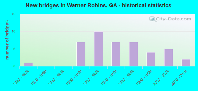
- New bridges - historical statistics
- 11920-1929
- 71950-1959
- 101960-1969
- 71970-1979
- 71980-1989
- 41990-1999
- 52000-2009
- 22010-2019

- Reconstructed bridges - Historical Statistics
- 11950-1959
- 01960-1969
- 01970-1979
- 71980-1989
- 21990-1999
- 22000-2009


- Bridge Condition - Deck
- 8.7%Very good
- 82.6%Good
- 8.7%Satisfactory

- Bridge Condition - Superstructure
- 21.7%Very good
- 78.3%Good

- Bridge Condition - Substructure
- 4.3%Very good
- 87.0%Good
- 4.3%Satisfactory
- 4.3%Fair

- Bridge Condition - Channel
- 23.7%Very good
- 50.0%Good
- 13.2%Satisfactory
- 13.2%Fair

- Bridge Condition - Culverts
- 85.0%Good
- 15.0%Satisfactory
Find on map >> Show street view
Structure Number: 1530015, Location: 2.5 MI SW OF CENTERVILLE (Lat: 32.604503, Lng: -83.714003), Route carried "on" structure: US 41, Year Built: 1928, Year Reconstructed: 1950, Status: Open, Structure Length: 1.74m (5.71ft), Average Daily Traffic: 9,040 (year 2012), Truck Traffic: 4%, Average Future Daily Traffic: 13,560 (year 2032), Design Load: H 15, Features Intersected: SANDY RUN CREEK
Minimum Vertical Clearance: 30+ m (98+ ft), Kilometerpoint: 37.015, Lanes on structure: 2, Base Highway Network: Yes, Owner: State Highway Agency, Approaching Roadway Width: 7.9m (25.9ft), Material/Design: Concrete, Design/Construction: Culvert, Number Of Spans In Main Unit: 8, Length of Maximum Span: 1.8m (5.9ft)
Condition: Channel: Good, Culverts: Satisfactory, Operating Rating: 35.3 metric tons, Method Used To Determine Operating Rating: Load Factor (LF), Inventory Rating: 21.7 metric tons, Method Used To Determine Inventory Rating: Load Factor (LF), Structural Evaluation: Somewhat better than minimum adequacy, Waterway Adequacy: Equal to present minimum criteria, Approach Roadway Alignment: Equal to present minimum criteria, Designated Inspection Frequency: Every 24 months, Inspection Date: August 2021, Bridge Improvement Cost: $223,000, Roadway Improvement Cost: $22,000, Total Project Cost: $334,000
Find on map >> Show street view
Structure Number: 1530026, Location: 2.8 MI E OF BONAIRE (Lat: 32.543100, Lng: -83.549497), Route carried "on" structure: State highway 96, Year Built: 1955, Year Reconstructed: 1985, Status: Open, Structure Length: 10.36m (33.99ft), Average Daily Traffic: 7,830 (year 2012), Truck Traffic: 1%, Average Future Daily Traffic: 11,745 (year 2032), Design Load: H 15, Features Intersected: OCMULGEE RIVER OVERFLOW
Minimum Vertical Clearance: 30+ m (98+ ft), Kilometerpoint: 17.703, Lanes on structure: 2, Base Highway Network: Yes, Owner: State Highway Agency, Approaching Roadway Width: 11.0m (36.1ft), Material/Design: Concrete, Design/Construction: Slab, Number Of Spans In Main Unit: 20, Length of Maximum Span: 5.2m (17.1ft), Curb-To-Curb Width: 13.4m (44.0ft), Out-to-Out Width: 14.4m (47.2ft)
Condition: Deck: Good, Superstructure: Good, Substructure: Good, Channel: Fair, Operating Rating: 33.5 metric tons, Method Used To Determine Operating Rating: Load Factor (LF), Inventory Rating: 19.9 metric tons, Method Used To Determine Inventory Rating: Load Factor (LF), Structural Evaluation: Somewhat better than minimum adequacy, Deck Geometry: Equal to present minimum criteria, Waterway Adequacy: Equal to present desirable criteria, Approach Roadway Alignment: Equal to present desirable criteria, Designated Inspection Frequency: Every 24 months, Inspection Date: July 2021, Bridge Improvement Cost: $1,328,000, Roadway Improvement Cost: $133,000, Total Project Cost: $1,993,000, Deck Structure Type: Concrete Precast Panels, Wearing Surface/Protective System: Wearing Surface: Bituminous
Find on map >> Show street view
Structure Number: 1530027, Location: 3.2 MI E OF BONAIRE (Lat: 32.542908, Lng: -83.543339), Route carried "on" structure: State highway 96, Year Built: 1955, Year Reconstructed: 1985, Status: Open, Structure Length: 11.40m (37.40ft), Average Daily Traffic: 7,830 (year 2012), Truck Traffic: 1%, Average Future Daily Traffic: 11,745 (year 2032), Design Load: H 15, Features Intersected: OCMULGEE RIVER OVERFLOW
Minimum Vertical Clearance: 30+ m (98+ ft), Kilometerpoint: 17.703, Lanes on structure: 2, Base Highway Network: Yes, Owner: State Highway Agency, Approaching Roadway Width: 11.0m (36.1ft), Material/Design: Concrete, Design/Construction: Slab, Number Of Spans In Main Unit: 22, Length of Maximum Span: 5.2m (17.1ft), Curb-To-Curb Width: 13.4m (44.0ft), Out-to-Out Width: 14.4m (47.2ft)
Condition: Deck: Good, Superstructure: Good, Substructure: Good, Channel: Very good, Operating Rating: 33.5 metric tons, Method Used To Determine Operating Rating: Load Factor (LF), Inventory Rating: 19.9 metric tons, Method Used To Determine Inventory Rating: Load Factor (LF), Structural Evaluation: Somewhat better than minimum adequacy, Deck Geometry: Equal to present minimum criteria, Waterway Adequacy: Equal to present desirable criteria, Approach Roadway Alignment: Equal to present desirable criteria, Designated Inspection Frequency: Every 24 months, Inspection Date: July 2021, Bridge Improvement Cost: $1,461,000, Roadway Improvement Cost: $146,000, Total Project Cost: $2,192,000, Deck Structure Type: Concrete Precast Panels, Wearing Surface/Protective System: Wearing Surface: Bituminous
Find on map >> Show street view
Structure Number: 1530028, Location: 3.3 MI E OF BONAIRE (Lat: 32.542689, Lng: -83.536808), Route carried "on" structure: State highway 96, Year Built: 1955, Year Reconstructed: 1985, Status: Open, Structure Length: 32.13m (105.41ft), Average Daily Traffic: 7,830 (year 2012), Truck Traffic: 1%, Average Future Daily Traffic: 11,745 (year 2032), Design Load: H 15, Features Intersected: OCMULGEE RIVER, Facility Carried by Structure: M.F.&J.D. BRIDGE
Minimum Vertical Clearance: 30+ m (98+ ft), Kilometerpoint: 17.703, Lanes on structure: 2, Base Highway Network: Yes, Owner: State Highway Agency, Approaching Roadway Width: 8.8m (28.9ft), Material/Design: Steel continuous, Design/Construction: Stringer/Multi-beam, Number Of Spans In Main Unit: 14, Length of Maximum Span: 30.5m (100.1ft), Curb-To-Curb Width: 13.4m (44.0ft), Out-to-Out Width: 14.4m (47.2ft)
Condition: Deck: Good, Superstructure: Good, Substructure: Fair, Channel: Satisfactory, Operating Rating: 39.0 metric tons, Method Used To Determine Operating Rating: Allowable Stress (AS), Inventory Rating: 18.1 metric tons, Method Used To Determine Inventory Rating: Allowable Stress (AS), Structural Evaluation: Meets minimum limits, Deck Geometry: Equal to present minimum criteria, Waterway Adequacy: Equal to present desirable criteria, Approach Roadway Alignment: Better than present minimum criteria, Designated Inspection Frequency: Every 24 months, Underwater Inspection Frequency: Every 24 months, Inspection Date: July 2021, Underwater Inspection Date: May 2021, Bridge Improvement Cost: $4,118,000, Roadway Improvement Cost: $412,000, Total Project Cost: $6,177,000, Deck Structure Type: Concrete Cast-file-Place, Wearing Surface/Protective System: Wearing Surface: Bituminous
Find on map >> Show street view
Structure Number: 1530036, Location: SE WARNER ROBINS (Lat: 32.576831, Lng: -83.589503), Route carried "on" structure: US 129, Year Built: 1981, Status: Open, Structure Length: 3.66m (12.01ft), Average Daily Traffic: 26,910 (year 2012), Truck Traffic: 1%, Average Future Daily Traffic: 40,365 (year 2032), Design Load: HS 20+Mod, Features Intersected: SANDY RUN CREEK
Minimum Vertical Clearance: 30+ m (98+ ft), Kilometerpoint: 25.750, Lanes on structure: 4, Base Highway Network: Yes, Owner: State Highway Agency, Approaching Roadway Width: 21.6m (70.9ft), Material/Design: Concrete, Design/Construction: Tee Beam, Number Of Spans In Main Unit: 3, Length of Maximum Span: 12.2m (40.0ft), Curb-To-Curb Width: 21.9m (71.9ft), Out-to-Out Width: 22.8m (74.8ft)
Condition: Deck: Good, Superstructure: Good, Substructure: Good, Channel: Good, Operating Rating: 37.1 metric tons, Method Used To Determine Operating Rating: Load Factor (LF), Inventory Rating: 22.6 metric tons, Method Used To Determine Inventory Rating: Load Factor (LF), Structural Evaluation: Somewhat better than minimum adequacy, Deck Geometry: Superior to present desirable criteria, Waterway Adequacy: Equal to present minimum criteria, Approach Roadway Alignment: Equal to present desirable criteria, Designated Inspection Frequency: Every 24 months, Underwater Inspection Frequency: Every 60 months, Inspection Date: July 2021, Underwater Inspection Date: May 2021, Bridge Improvement Cost: $725,000, Roadway Improvement Cost: $72,000, Total Project Cost: $1,087,000, Deck Structure Type: Concrete Cast-file-Place, Wearing Surface/Protective System: Wearing Surface: Epoxy Overlay, Membrane: Epoxy, Deck Protection: Bituminous
Find on map >> Show street view
Structure Number: 1530037, Location: NORTH - WARNER ROBINS (Lat: 32.664189, Lng: -83.619328), Route carried "on" structure: US 129, Year Built: 1953, Status: Open, Structure Length: 12.25m (40.19ft), Average Daily Traffic: 25,060 (year 2012), Truck Traffic: 3%, Average Future Daily Traffic: 37,590 (year 2032), Design Load: HS 20, Features Intersected: ECHECONNEE CREEK
Minimum Vertical Clearance: 30+ m (98+ ft), Kilometerpoint: 37.015, Lanes on structure: 2, Base Highway Network: Yes, Owner: State Highway Agency, Approaching Roadway Width: 7.3m (24.0ft), Skew: 12 degrees, Material/Design: Steel, Design/Construction: Stringer/Multi-beam, Number Of Spans In Main Unit: 1, Number Of Approach Spans: 10, Length of Maximum Span: 23.5m (77.1ft), Curb or Sidewalk Widths: Left: 0.6m (2.0ft), Right: 0.6m (2.0ft), Curb-To-Curb Width: 8.5m (27.9ft), Out-to-Out Width: 10.3m (33.8ft)
Condition: Deck: Good, Superstructure: Good, Substructure: Good, Channel: Good, Operating Rating: 37.1 metric tons, Method Used To Determine Operating Rating: Load Factor (LF), Inventory Rating: 22.6 metric tons, Method Used To Determine Inventory Rating: Load Factor (LF), Structural Evaluation: Somewhat better than minimum adequacy, Deck Geometry: High priority of corrective action, Waterway Adequacy: Equal to present minimum criteria, Approach Roadway Alignment: Better than present minimum criteria, Length Of Structure Improvement: 18.84m (61.81ft), Designated Inspection Frequency: Every 24 months, Underwater Inspection Frequency: Every 60 months, Inspection Date: July 2021, Underwater Inspection Date: May 2021, Bridge Improvement Cost: $1,571,000, Roadway Improvement Cost: $157,000, Total Project Cost: $2,356,000, Deck Structure Type: Concrete Cast-file-Place, Wearing Surface/Protective System: Wearing Surface: Bituminous
Find on map >> Show street view
Structure Number: 1530039, Location: WARNER ROBINS -CENTER (Lat: 32.618350, Lng: -83.651589), Route carried "on" structure: Ramp State highway 247, Year Built: 1963, Status: Open, Structure Length: 1.13m (3.71ft), Average Daily Traffic: 28,310 (year 2012), Truck Traffic: 1%, Average Future Daily Traffic: 42,465 (year 2032), Design Load: HS 20+Mod, Features Intersected: BAY GALL CREEK
Minimum Vertical Clearance: 30+ m (98+ ft), Kilometerpoint: 6.437, Lanes on structure: 5, Base Highway Network: Yes, Owner: State Highway Agency, Approaching Roadway Width: 19.5m (64.0ft), Skew: 3 degrees, Material/Design: Concrete, Design/Construction: Culvert, Number Of Spans In Main Unit: 3, Length of Maximum Span: 3.7m (12.1ft)
Condition: Channel: Good, Culverts: Good, Operating Rating: 59.8 metric tons, Method Used To Determine Operating Rating: Load Factor (LF), Inventory Rating: 36.2 metric tons, Method Used To Determine Inventory Rating: Load Factor (LF), Structural Evaluation: Better than present minimum criteria, Waterway Adequacy: Equal to present desirable criteria, Approach Roadway Alignment: Equal to present desirable criteria, Designated Inspection Frequency: Every 24 months, Inspection Date: July 2021, Bridge Improvement Cost: $263,000, Roadway Improvement Cost: $26,000, Total Project Cost: $394,000
Find on map >> Show street view
Structure Number: 1530059, Location: .1 MI S OF WARNER ROBINS (Lat: 32.575631, Lng: -83.663239), Route carried "on" structure: City street 5121, Year Built: 1983, Year Reconstructed: 2003, Status: Open, Structure Length: 3.66m (12.01ft), Average Daily Traffic: 15,100 (year 2012), Truck Traffic: 1%, Average Future Daily Traffic: 22,650 (year 2032), Design Load: HS 20+Mod, Features Intersected: SANDY RUN CREEK, Facility Carried by Structure: HOUSTON LAKE ROAD
Minimum Vertical Clearance: 30+ m (98+ ft), Kilometerpoint: 1.609, Lanes on structure: 4, Base Highway Network: Yes, Owner: County Highway Agency, Approaching Roadway Width: 17.1m (56.1ft), Skew: 20 degrees, Material/Design: Prestressed concrete, Design/Construction: Stringer/Multi-beam, Number Of Spans In Main Unit: 3, Length of Maximum Span: 12.2m (40.0ft), Curb or Sidewalk Widths: Left: 1.8m (5.9ft), Right: 1.8m (5.9ft), Curb-To-Curb Width: 21.6m (70.9ft), Out-to-Out Width: 26.1m (85.6ft)
Condition: Deck: Good, Superstructure: Very good, Substructure: Good, Channel: Good, Operating Rating: 80.7 metric tons, Method Used To Determine Operating Rating: Load Factor (LF), Inventory Rating: 33.5 metric tons, Method Used To Determine Inventory Rating: Load Factor (LF), Structural Evaluation: Better than present minimum criteria, Deck Geometry: Superior to present desirable criteria, Waterway Adequacy: Equal to present desirable criteria, Approach Roadway Alignment: Equal to present desirable criteria, Designated Inspection Frequency: Every 24 months, Inspection Date: August 2021, Bridge Improvement Cost: $725,000, Roadway Improvement Cost: $72,000, Total Project Cost: $1,087,000, Deck Structure Type: Concrete Precast Panels
Find on map >> Show street view
Structure Number: 1530063, Location: 5 MI W OF WARNER ROBINS (Lat: 32.634939, Lng: -83.710639), Route carried "on" structure: County highway 1508, Year Built: 1956, Status: Open, Structure Length: 0.64m (2.10ft), Average Daily Traffic: 6,530 (year 2012), Truck Traffic: 1%, Average Future Daily Traffic: 9,795 (year 2032), Design Load: H 15, Features Intersected: BAY GALL CREEK TRIB, Facility Carried by Structure: WHITE ROAD
Minimum Vertical Clearance: 30+ m (98+ ft), Kilometerpoint: 1.609, Lanes on structure: 2, Base Highway Network: Yes, Owner: County Highway Agency, Approaching Roadway Width: 6.7m (22.0ft), Material/Design: Concrete, Design/Construction: Culvert, Number Of Spans In Main Unit: 2, Length of Maximum Span: 3.0m (9.8ft)
Condition: Channel: Good, Culverts: Good, Operating Rating: 41.7 metric tons, Method Used To Determine Operating Rating: Field evaluation and documented engineering judgment, Inventory Rating: 24.4 metric tons, Method Used To Determine Inventory Rating: Field evaluation and documented engineering judgment, Structural Evaluation: Equal to present minimum criteria, Waterway Adequacy: Equal to present minimum criteria, Approach Roadway Alignment: Better than present minimum criteria, Designated Inspection Frequency: Every 24 months, Inspection Date: July 2021, Bridge Improvement Cost: $82,000, Roadway Improvement Cost: $8,000, Total Project Cost: $123,000
Find on map >> Show street view
Structure Number: 1530064, Location: WARNER ROBINS - SE SECT. (Lat: 32.593728, Lng: -83.619658), Route carried "on" structure: City street 762, Year Built: 1978, Status: Open, Structure Length: 4.88m (16.01ft), Average Daily Traffic: 22,470 (year 2012), Truck Traffic: 2%, Average Future Daily Traffic: 33,705 (year 2032), Design Load: HS 20+Mod, Features Intersected: BAY GALL CREEK, Facility Carried by Structure: R.B. RUSSELL PKWY.
Minimum Vertical Clearance: 30+ m (98+ ft), Kilometerpoint: 4.828, Lanes on structure: 5, Base Highway Network: Yes, Owner: City or Municipal Highway Agency, Approaching Roadway Width: 25.9m (85.0ft), Material/Design: Concrete, Design/Construction: Tee Beam, Number Of Spans In Main Unit: 4, Length of Maximum Span: 12.2m (40.0ft), Curb-To-Curb Width: 26.5m (86.9ft), Out-to-Out Width: 27.6m (90.6ft)
Condition: Deck: Good, Superstructure: Good, Substructure: Good, Channel: Good, Operating Rating: 36.2 metric tons, Method Used To Determine Operating Rating: Load Factor (LF), Inventory Rating: 21.7 metric tons, Method Used To Determine Inventory Rating: Load Factor (LF), Structural Evaluation: Somewhat better than minimum adequacy, Deck Geometry: Superior to present desirable criteria, Waterway Adequacy: Equal to present desirable criteria, Approach Roadway Alignment: Equal to present desirable criteria, Designated Inspection Frequency: Every 24 months, Inspection Date: August 2021, Bridge Improvement Cost: $1,137,000, Roadway Improvement Cost: $114,000, Total Project Cost: $1,705,000, Deck Structure Type: Concrete Cast-file-Place
Find on map >> Show street view
Structure Number: 1530065, Location: WARNER ROBINS - SE SECT. (Lat: 32.593803, Lng: -83.594086), Route carried "on" structure: City street 762, Year Built: 1978, Status: Open, Structure Length: 4.75m (15.58ft), Average Daily Traffic: 19,760 (year 2011), Truck Traffic: 1%, Average Future Daily Traffic: 29,640 (year 2031), Design Load: HS 20+Mod, Features Intersected: NS RAILROAD, Facility Carried by Structure: R. B. RUSSELL PKY
Minimum Vertical Clearance: 30+ m (98+ ft), Kilometerpoint: 6.437, Lanes on structure: 6, Base Highway Network: Yes, Owner: City or Municipal Highway Agency, Approaching Roadway Width: 25.6m (84.0ft), Skew: 30 degrees, Material/Design: Prestressed concrete, Design/Construction: Stringer/Multi-beam, Number Of Spans In Main Unit: 3, Length of Maximum Span: 18.3m (60.0ft), Curb-To-Curb Width: 34.3m (112.5ft), Out-to-Out Width: 36.8m (120.7ft)
Condition: Deck: Good, Superstructure: Good, Substructure: Good, Channel: Very good, Operating Rating: 52.6 metric tons, Method Used To Determine Operating Rating: Load Factor (LF), Inventory Rating: 32.6 metric tons, Method Used To Determine Inventory Rating: Load Factor (LF), Structural Evaluation: Better than present minimum criteria, Deck Geometry: Superior to present desirable criteria, Underclear: Superior to present desirable criteria, Approach Roadway Alignment: Equal to present desirable criteria, Designated Inspection Frequency: Every 24 months, Inspection Date: July 2021, Bridge Improvement Cost: $1,274,000, Roadway Improvement Cost: $127,000, Total Project Cost: $1,912,000, Deck Structure Type: Concrete Cast-file-Place
Find on map >> Show street view
Structure Number: 1530067, Location: WARNER ROBINS - SE SECT. (Lat: 32.593408, Lng: -83.590906), Route carried "on" structure: City street 762, Year Built: 1975, Status: Open, Structure Length: 7.50m (24.61ft), Average Daily Traffic: 22,470 (year 2012), Truck Traffic: 2%, Average Future Daily Traffic: 33,705 (year 2032), Design Load: HS 20+Mod, Features Intersected: SR 247 (US 129), Facility Carried by Structure: R. B. RUSSELL PKY
Minimum Vertical Clearance: 30+ m (98+ ft), Kilometerpoint: 6.437, Lanes on structure: 5, Lanes under structure: 6, Base Highway Network: Yes, Owner: State Highway Agency, Approaching Roadway Width: 28.0m (91.9ft), Skew: 32 degrees, Material/Design: Prestressed concrete continuous, Design/Construction: Box Beam or Girders - Multiple, Number Of Spans In Main Unit: 2, Length of Maximum Span: 39.6m (129.9ft), Curb-To-Curb Width: 33.9m (111.2ft), Out-to-Out Width: 35.5m (116.5ft)
Condition: Deck: Good, Superstructure: Good, Substructure: Good, Operating Rating: 61.6 metric tons, Method Used To Determine Operating Rating: Allowable Stress (AS), Inventory Rating: 32.6 metric tons, Method Used To Determine Inventory Rating: Allowable Stress (AS), Structural Evaluation: Better than present minimum criteria, Deck Geometry: Superior to present desirable criteria, Underclear: Somewhat better than minimum adequacy, Approach Roadway Alignment: Equal to present desirable criteria, Designated Inspection Frequency: Every 24 months, Inspection Date: July 2021, Bridge Improvement Cost: $1,485,000, Roadway Improvement Cost: $149,000, Total Project Cost: $2,228,000, Deck Structure Type: Concrete Cast-file-Place
Find on map >> Show street view
Structure Number: 153007, Location: 2.5 MI S OF PERRY (Lat: 32.426808, Lng: -83.714058), Route carried "on" structure: State highway 224, Year Built: 1976, Year Reconstructed: 1994, Status: Open, Structure Length: 3.66m (12.01ft), Average Daily Traffic: 2,900 (year 2012), Truck Traffic: 18%, Average Future Daily Traffic: 4,350 (year 2032), Design Load: HS 15, Features Intersected: FLAT CREEK, Facility Carried by Structure: LARRY WALKER PKWY
Minimum Vertical Clearance: 30+ m (98+ ft), Kilometerpoint: 12.875, Lanes on structure: 2, Base Highway Network: Yes, Owner: State Highway Agency, Approaching Roadway Width: 8.5m (27.9ft), Skew: 13 degrees, Material/Design: Concrete, Design/Construction: Tee Beam, Number Of Spans In Main Unit: 4, Length of Maximum Span: 9.1m (29.9ft), Curb-To-Curb Width: 11.6m (38.1ft), Out-to-Out Width: 12.6m (41.3ft)
Condition: Deck: Good, Superstructure: Good, Substructure: Good, Channel: Very good, Operating Rating: 40.8 metric tons, Method Used To Determine Operating Rating: Load Factor (LF), Inventory Rating: 24.4 metric tons, Method Used To Determine Inventory Rating: Load Factor (LF), Structural Evaluation: Equal to present minimum criteria, Deck Geometry: Better than present minimum criteria, Waterway Adequacy: Equal to present desirable criteria, Approach Roadway Alignment: Better than present minimum criteria, Designated Inspection Frequency: Every 24 months, Inspection Date: August 2021, Bridge Improvement Cost: $469,000, Roadway Improvement Cost: $47,000, Total Project Cost: $703,000, Deck Structure Type: Concrete Cast-file-Place
Find on map >> Show street view
Structure Number: 1530072, Location: WARNER ROBINS-WESTSIDE (Lat: 32.629078, Lng: -83.605722), Route carried "on" structure: City street 5103, Year Built: 1972, Status: Open, Structure Length: 0.94m (3.08ft), Average Daily Traffic: 6,140 (year 2012), Truck Traffic: 1%, Average Future Daily Traffic: 9,210 (year 2032), Design Load: HS 20+Mod, Features Intersected: BAY GALL CREEK TRIB., Facility Carried by Structure: GREEN STREET
Minimum Vertical Clearance: 30+ m (98+ ft), Kilometerpoint: 0.000, Lanes on structure: 4, Base Highway Network: Yes, Owner: City or Municipal Highway Agency, Approaching Roadway Width: 15.8m (51.8ft), Skew: 4 degrees, Material/Design: Concrete, Design/Construction: Culvert, Number Of Spans In Main Unit: 2, Length of Maximum Span: 4.6m (15.1ft)
Condition: Channel: Fair, Culverts: Good, Operating Rating: 55.3 metric tons, Method Used To Determine Operating Rating: Field evaluation and documented engineering judgment, Inventory Rating: 32.6 metric tons, Method Used To Determine Inventory Rating: Field evaluation and documented engineering judgment, Structural Evaluation: Better than present minimum criteria, Waterway Adequacy: Equal to present minimum criteria, Approach Roadway Alignment: Better than present minimum criteria, Designated Inspection Frequency: Every 24 months, Inspection Date: July 2021, Bridge Improvement Cost: $187,000, Roadway Improvement Cost: $19,000, Total Project Cost: $281,000
Find on map >> Show street view
Structure Number: 1530073, Location: WARNER ROBINS-WESTSIDE (Lat: 32.631789, Lng: -83.668519), Route carried "on" structure: City street 5105, Year Built: 1960, Status: Open, Structure Length: 0.64m (2.10ft), Average Daily Traffic: 8,680 (year 2012), Truck Traffic: 1%, Average Future Daily Traffic: 13,020 (year 2032), Design Load: H 15, Features Intersected: BAY GALL CREEK, Facility Carried by Structure: ELBERTA-CENTERVLLE
Minimum Vertical Clearance: 30+ m (98+ ft), Kilometerpoint: 1.609, Lanes on structure: 2, Base Highway Network: Yes, Owner: City or Municipal Highway Agency, Approaching Roadway Width: 6.1m (20.0ft), Material/Design: Concrete, Design/Construction: Culvert, Number Of Spans In Main Unit: 2, Length of Maximum Span: 3.0m (9.8ft)
Condition: Channel: Good, Culverts: Good, Operating Rating: 41.7 metric tons, Method Used To Determine Operating Rating: Field evaluation and documented engineering judgment, Inventory Rating: 24.4 metric tons, Method Used To Determine Inventory Rating: Field evaluation and documented engineering judgment, Structural Evaluation: Equal to present minimum criteria, Waterway Adequacy: Equal to present minimum criteria, Approach Roadway Alignment: Somewhat better than minimum adequacy, Designated Inspection Frequency: Every 24 months, Inspection Date: August 2021, Bridge Improvement Cost: $82,000, Roadway Improvement Cost: $8,000, Total Project Cost: $123,000
Find on map >> Show street view
Structure Number: 1530076, Location: WARNER ROBINS-WESTSIDE (Lat: 32.615069, Lng: -83.648819), Route carried "on" structure: City street 5116, Year Built: 1965, Status: Open, Structure Length: 0.98m (3.22ft), Average Daily Traffic: 10,570 (year 2012), Truck Traffic: 1%, Average Future Daily Traffic: 15,855 (year 2032), Design Load: H 15, Features Intersected: BAY GALL CREEK, Facility Carried by Structure: CORDER ROAD
Minimum Vertical Clearance: 30+ m (98+ ft), Kilometerpoint: 1.609, Lanes on structure: 3, Base Highway Network: Yes, Owner: City or Municipal Highway Agency, Approaching Roadway Width: 12.2m (40.0ft), Material/Design: Concrete, Design/Construction: Culvert, Number Of Spans In Main Unit: 3, Length of Maximum Span: 3.0m (9.8ft), Curb or Sidewalk Widths: Left: 0.6m (2.0ft), Right: 2.7m (8.9ft)
Condition: Channel: Good, Culverts: Good, Operating Rating: 41.7 metric tons, Method Used To Determine Operating Rating: Field evaluation and documented engineering judgment, Inventory Rating: 24.4 metric tons, Method Used To Determine Inventory Rating: Field evaluation and documented engineering judgment, Structural Evaluation: Equal to present minimum criteria, Waterway Adequacy: Equal to present minimum criteria, Approach Roadway Alignment: Equal to present desirable criteria, Designated Inspection Frequency: Every 24 months, Inspection Date: August 2021, Bridge Improvement Cost: $125,000, Roadway Improvement Cost: $13,000, Total Project Cost: $188,000
Find on map >> Show street view
Structure Number: 1530077, Location: 4 MI S OF WARNER ROBINS (Lat: 32.572369, Lng: -83.609308), Route carried "on" structure: City street 5119, Year Built: 1976, Status: Open, Structure Length: 0.79m (2.59ft), Average Daily Traffic: 4,610 (year 2012), Truck Traffic: 1%, Average Future Daily Traffic: 6,915 (year 2032), Design Load: HS 20+Mod, Features Intersected: SANDY RUN CREEK TRIB., Facility Carried by Structure: SANDY RUN ROAD
Minimum Vertical Clearance: 30+ m (98+ ft), Kilometerpoint: 8.047, Lanes on structure: 2, Base Highway Network: Yes, Owner: City or Municipal Highway Agency, Approaching Roadway Width: 7.9m (25.9ft), Material/Design: Concrete, Design/Construction: Culvert, Number Of Spans In Main Unit: 3, Length of Maximum Span: 2.4m (7.9ft)
Condition: Channel: Satisfactory, Culverts: Good, Operating Rating: 55.3 metric tons, Method Used To Determine Operating Rating: Field evaluation and documented engineering judgment, Inventory Rating: 32.6 metric tons, Method Used To Determine Inventory Rating: Field evaluation and documented engineering judgment, Structural Evaluation: Better than present minimum criteria, Waterway Adequacy: Equal to present minimum criteria, Approach Roadway Alignment: Better than present minimum criteria, Designated Inspection Frequency: Every 24 months, Underwater Inspection Frequency: Every 60 months, Inspection Date: July 2021, Underwater Inspection Date: May 2021, Bridge Improvement Cost: $102,000, Roadway Improvement Cost: $10,000, Total Project Cost: $152,000
Find on map >> Show street view
Structure Number: 153008, Location: WARNER ROBINS-SOUTHSIDE (Lat: 32.583819, Lng: -83.623294), Route carried "on" structure: City street 5108, Year Built: 1988, Status: Open, Structure Length: 1.68m (5.51ft), Average Daily Traffic: 12,180 (year 2012), Truck Traffic: 1%, Average Future Daily Traffic: 18,270 (year 2032), Design Load: HS 20+Mod, Features Intersected: SANDY RUN CREEK, Facility Carried by Structure: MOODY ROAD
Minimum Vertical Clearance: 30+ m (98+ ft), Kilometerpoint: 3.219, Lanes on structure: 5, Base Highway Network: Yes, Owner: City or Municipal Highway Agency, Approaching Roadway Width: 20.1m (65.9ft), Material/Design: Concrete, Design/Construction: Culvert, Number Of Spans In Main Unit: 5, Length of Maximum Span: 3.0m (9.8ft)
Condition: Channel: Fair, Culverts: Satisfactory, Operating Rating: 55.3 metric tons, Method Used To Determine Operating Rating: Field evaluation and documented engineering judgment, Inventory Rating: 32.6 metric tons, Method Used To Determine Inventory Rating: Field evaluation and documented engineering judgment, Structural Evaluation: Equal to present minimum criteria, Waterway Adequacy: Equal to present desirable criteria, Approach Roadway Alignment: Equal to present desirable criteria, Designated Inspection Frequency: Every 24 months, Underwater Inspection Frequency: Every 60 months, Inspection Date: August 2021, Underwater Inspection Date: May 2021, Bridge Improvement Cost: $391,000, Roadway Improvement Cost: $39,000, Total Project Cost: $586,000
Find on map >> Show street view
Structure Number: 1530083, Location: WEST - WARNER ROBINS (Lat: 32.631061, Lng: -83.668028), Route carried "on" structure: City street 5126, Year Built: 1984, Year Reconstructed: 2009, Status: Open, Structure Length: 0.67m (2.20ft), Average Daily Traffic: 9,950 (year 2012), Truck Traffic: 1%, Average Future Daily Traffic: 14,925 (year 2032), Design Load: HS 20+Mod, Features Intersected: BAY GALL CREEK, Facility Carried by Structure: CARL VINSON PKWY.
Minimum Vertical Clearance: 30+ m (98+ ft), Kilometerpoint: 4.828, Lanes on structure: 5, Base Highway Network: Yes, Owner: City or Municipal Highway Agency, Approaching Roadway Width: 18.3m (60.0ft), Skew: 1 degrees, Material/Design: Concrete, Design/Construction: Culvert, Number Of Spans In Main Unit: 2, Length of Maximum Span: 3.0m (9.8ft)
Condition: Channel: Fair, Culverts: Good, Operating Rating: 55.3 metric tons, Method Used To Determine Operating Rating: Field evaluation and documented engineering judgment, Inventory Rating: 32.6 metric tons, Method Used To Determine Inventory Rating: Field evaluation and documented engineering judgment, Structural Evaluation: Better than present minimum criteria, Waterway Adequacy: Equal to present minimum criteria, Approach Roadway Alignment: Equal to present desirable criteria, Designated Inspection Frequency: Every 24 months, Inspection Date: August 2021, Bridge Improvement Cost: $156,000, Roadway Improvement Cost: $16,000, Total Project Cost: $234,000
Find on map >> Show street view
Structure Number: 153009, Location: 3.5 MI W OF PERRY (Lat: 32.485778, Lng: -83.781608), Route carried "on" structure: US 341, Year Built: 1994, Status: Open, Structure Length: 4.02m (13.19ft), Average Daily Traffic: 5,960 (year 2012), Truck Traffic: 1%, Average Future Daily Traffic: 8,940 (year 2032), Design Load: HS 20+Mod, Features Intersected: BAY CREEK
Minimum Vertical Clearance: 30+ m (98+ ft), Kilometerpoint: 28.968, Lanes on structure: 2, Base Highway Network: Yes, Owner: State Highway Agency, Approaching Roadway Width: 8.2m (26.9ft), Material/Design: Concrete, Design/Construction: Tee Beam, Number Of Spans In Main Unit: 4, Length of Maximum Span: 10.1m (33.1ft), Curb-To-Curb Width: 12.2m (40.0ft), Out-to-Out Width: 13.2m (43.3ft)
Condition: Deck: Good, Superstructure: Good, Substructure: Good, Channel: Good, Operating Rating: 57.1 metric tons, Method Used To Determine Operating Rating: Load Factor (LF), Inventory Rating: 34.4 metric tons, Method Used To Determine Inventory Rating: Load Factor (LF), Structural Evaluation: Better than present minimum criteria, Deck Geometry: Somewhat better than minimum adequacy, Waterway Adequacy: Equal to present desirable criteria, Approach Roadway Alignment: Equal to present minimum criteria, Designated Inspection Frequency: Every 24 months, Underwater Inspection Frequency: Every 60 months, Inspection Date: August 2021, Underwater Inspection Date: September 2021, Bridge Improvement Cost: $516,000, Roadway Improvement Cost: $52,000, Total Project Cost: $774,000, Deck Structure Type: Concrete Cast-file-Place
Find on map >> Show street view
Structure Number: 1530094, Location: NORTH WARNER ROBINS (Lat: 32.664200, Lng: -83.619569), Route carried "on" structure: US 129, Year Built: 1995, Status: Open, Structure Length: 13.26m (43.50ft), Average Daily Traffic: 25,060 (year 2012), Truck Traffic: 3%, Average Future Daily Traffic: 37,590 (year 2032), Design Load: HS 20+Mod, Features Intersected: ECHECONNEE CREEK
Minimum Vertical Clearance: 30+ m (98+ ft), Kilometerpoint: 37.015, Lanes on structure: 2, Base Highway Network: Yes, Owner: State Highway Agency, Approaching Roadway Width: 7.3m (24.0ft), Skew: 14 degrees, Material/Design: Prestressed concrete, Design/Construction: Stringer/Multi-beam, Number Of Spans In Main Unit: 10, Length of Maximum Span: 22.9m (75.1ft), Curb-To-Curb Width: 11.6m (38.1ft), Out-to-Out Width: 12.6m (41.3ft)
Condition: Deck: Good, Superstructure: Very good, Substructure: Good, Channel: Good, Operating Rating: 79.8 metric tons, Method Used To Determine Operating Rating: Load Factor (LF), Inventory Rating: 39.9 metric tons, Method Used To Determine Inventory Rating: Load Factor (LF), Structural Evaluation: Better than present minimum criteria, Deck Geometry: Better than present minimum criteria, Waterway Adequacy: Equal to present desirable criteria, Approach Roadway Alignment: High priority of corrective action, Designated Inspection Frequency: Every 24 months, Underwater Inspection Frequency: Every 60 months, Inspection Date: July 2021, Underwater Inspection Date: May 2021, Bridge Improvement Cost: $1,700,000, Roadway Improvement Cost: $170,000, Total Project Cost: $2,549,000, Deck Structure Type: Concrete Cast-file-Place
Find on map >> Show street view
Structure Number: 153501, Location: 4 MI SE OF ELKO (Lat: 32.297278, Lng: -83.643989), Route carried "on" structure: County highway 233, Year Built: 1963, Year Reconstructed: 2003, Status: Open, Structure Length: 3.05m (10.01ft), Average Daily Traffic: 490 (year 2012), Truck Traffic: 1%, Average Future Daily Traffic: 735 (year 2032), Design Load: H 15, Features Intersected: BIG CREEK, Facility Carried by Structure: CO LINE CHURCH RD
Minimum Vertical Clearance: 30+ m (98+ ft), Kilometerpoint: 1.609, Lanes on structure: 2, Base Highway Network: Yes, Owner: County Highway Agency, Approaching Roadway Width: 6.1m (20.0ft), Material/Design: Prestressed concrete, Design/Construction: Channel Beam, Number Of Spans In Main Unit: 5, Length of Maximum Span: 6.1m (20.0ft), Curb-To-Curb Width: 7.3m (24.0ft), Out-to-Out Width: 7.7m (25.3ft)
Condition: Deck: Good, Superstructure: Good, Substructure: Good, Channel: Good, Operating Rating: 38.1 metric tons, Method Used To Determine Operating Rating: Load Factor (LF), Inventory Rating: 22.6 metric tons, Method Used To Determine Inventory Rating: Load Factor (LF), Structural Evaluation: Equal to present minimum criteria, Deck Geometry: Meets minimum limits, Waterway Adequacy: Equal to present minimum criteria, Approach Roadway Alignment: Equal to present minimum criteria, Length Of Structure Improvement: 43.31m (142.09ft), Designated Inspection Frequency: Every 24 months, Inspection Date: July 2021, Bridge Improvement Cost: $391,000, Roadway Improvement Cost: $39,000, Total Project Cost: $586,000, Deck Structure Type: Concrete Precast Panels
Find on map >> Show street view
Structure Number: 1535015, Location: WARNER ROBINS-WESTSIDE (Lat: 32.612858, Lng: -83.648608), Route carried "on" structure: City street 372, Year Built: 1980, Status: Open, Structure Length: 1.34m (4.40ft), Average Daily Traffic: 110 (year 2012), Truck Traffic: 1%, Average Future Daily Traffic: 165 (year 2032), Design Load: HS 20+Mod, Features Intersected: BAY GALL CREEK, Facility Carried by Structure: SPRUCE STREET
Minimum Vertical Clearance: 30+ m (98+ ft), Kilometerpoint: 0.000, Lanes on structure: 2, Base Highway Network: Yes, Owner: City or Municipal Highway Agency, Approaching Roadway Width: 5.8m (19.0ft), Material/Design: Concrete, Design/Construction: Culvert, Number Of Spans In Main Unit: 4, Length of Maximum Span: 3.0m (9.8ft)
Condition: Channel: Satisfactory, Culverts: Good, Operating Rating: 55.3 metric tons, Method Used To Determine Operating Rating: Field evaluation and documented engineering judgment, Inventory Rating: 32.6 metric tons, Method Used To Determine Inventory Rating: Field evaluation and documented engineering judgment, Structural Evaluation: Better than present minimum criteria, Waterway Adequacy: Equal to present minimum criteria, Approach Roadway Alignment: Meets minimum limits, Designated Inspection Frequency: Every 24 months, Inspection Date: August 2021, Bridge Improvement Cost: $172,000, Roadway Improvement Cost: $17,000, Total Project Cost: $258,000
Find on map >> Show street view
Structure Number: 1535018, Location: WARNER ROBINS-EASTSIDE (Lat: 32.627939, Lng: -83.606758), Route carried "on" structure: City street 182, Year Built: 1960, Status: Open, Structure Length: 0.91m (2.99ft), Average Daily Traffic: 1,140 (year 2012), Truck Traffic: 1%, Average Future Daily Traffic: 1,710 (year 2032), Design Load: H 15, Features Intersected: BAY GALL CREEK TRIB., Facility Carried by Structure: MYRTLE STREET
Minimum Vertical Clearance: 30+ m (98+ ft), Kilometerpoint: 1.609, Lanes on structure: 3, Base Highway Network: Yes, Owner: City or Municipal Highway Agency, Approaching Roadway Width: 10.1m (33.1ft), Skew: 4 degrees, Material/Design: Concrete, Design/Construction: Culvert, Number Of Spans In Main Unit: 2, Length of Maximum Span: 4.3m (14.1ft)
Condition: Channel: Fair, Culverts: Good, Operating Rating: 41.7 metric tons, Method Used To Determine Operating Rating: Field evaluation and documented engineering judgment, Inventory Rating: 24.4 metric tons, Method Used To Determine Inventory Rating: Field evaluation and documented engineering judgment, Structural Evaluation: Equal to present minimum criteria, Waterway Adequacy: Better than present minimum criteria, Approach Roadway Alignment: Equal to present desirable criteria, Designated Inspection Frequency: Every 24 months, Inspection Date: July 2021, Bridge Improvement Cost: $149,000, Roadway Improvement Cost: $15,000, Total Project Cost: $224,000
Find on map >> Show street view
Structure Number: 153502, Location: IN CENTERVILLE (Lat: 32.623511, Lng: -83.659606), Route carried "on" structure: City street 97, Year Built: 1995, Status: Open, Structure Length: 0.98m (3.22ft), Average Daily Traffic: 1,610 (year 2012), Truck Traffic: 2%, Average Future Daily Traffic: 2,415 (year 2032), Design Load: H 15, Features Intersected: BAY GALL CREEK, Facility Carried by Structure: KNODISHALL DRIVE
Minimum Vertical Clearance: 30+ m (98+ ft), Kilometerpoint: 0.000, Lanes on structure: 2, Base Highway Network: Yes, Owner: City or Municipal Highway Agency, Approaching Roadway Width: 5.5m (18.0ft), Material/Design: Concrete, Design/Construction: Culvert, Number Of Spans In Main Unit: 3, Length of Maximum Span: 3.0m (9.8ft), Curb or Sidewalk Widths: Left: 0.2m (0.7ft), Right: 0.2m (0.7ft)
Condition: Channel: Good, Culverts: Good, Operating Rating: 41.7 metric tons, Method Used To Determine Operating Rating: Field evaluation and documented engineering judgment, Inventory Rating: 24.4 metric tons, Method Used To Determine Inventory Rating: Field evaluation and documented engineering judgment, Structural Evaluation: Equal to present minimum criteria, Waterway Adequacy: Better than present minimum criteria, Approach Roadway Alignment: Equal to present minimum criteria, Designated Inspection Frequency: Every 24 months, Inspection Date: August 2021, Bridge Improvement Cost: $125,000, Roadway Improvement Cost: $13,000, Total Project Cost: $188,000
Find on map >> Show street view
Structure Number: 1535022, Location: 2 MI S OF CENTERVILLE (Lat: 32.599439, Lng: -83.692769), Route carried "on" structure: County highway 618, Year Built: 1985, Status: Open, Structure Length: 1.19m (3.90ft), Average Daily Traffic: 1,010 (year 2012), Truck Traffic: 1%, Average Future Daily Traffic: 1,515 (year 2032), Design Load: H 15, Features Intersected: SANDY RUN CREEK, Facility Carried by Structure: SMOKE RISE DRIVE
Minimum Vertical Clearance: 30+ m (98+ ft), Kilometerpoint: 1.609, Lanes on structure: 2, Base Highway Network: Yes, Owner: County Highway Agency, Approaching Roadway Width: 6.7m (22.0ft), Material/Design: Steel, Design/Construction: Culvert, Number Of Spans In Main Unit: 5, Length of Maximum Span: 1.8m (5.9ft)
Condition: Channel: Good, Culverts: Satisfactory, Operating Rating: 41.7 metric tons, Method Used To Determine Operating Rating: Field evaluation and documented engineering judgment, Inventory Rating: 24.4 metric tons, Method Used To Determine Inventory Rating: Field evaluation and documented engineering judgment, Structural Evaluation: Equal to present minimum criteria, Waterway Adequacy: Better than present minimum criteria, Approach Roadway Alignment: Somewhat better than minimum adequacy, Designated Inspection Frequency: Every 24 months, Inspection Date: August 2021, Bridge Improvement Cost: $152,000, Roadway Improvement Cost: $15,000, Total Project Cost: $229,000
Find on map >> Show street view
Structure Number: 1535023, Location: SOUTH WARNER ROBINS (Lat: 32.585028, Lng: -83.648269), Route carried "on" structure: County highway 649, Year Built: 1960, Status: Open, Structure Length: 0.70m (2.30ft), Average Daily Traffic: 180 (year 2012), Truck Traffic: 1%, Average Future Daily Traffic: 270 (year 2032), Design Load: H 15, Features Intersected: SANDY RUN CREEK TRIB., Facility Carried by Structure: SPRINGWOOD DRIVE
Minimum Vertical Clearance: 30+ m (98+ ft), Kilometerpoint: 1.609, Lanes on structure: 2, Base Highway Network: Yes, Owner: County Highway Agency, Approaching Roadway Width: 8.5m (27.9ft), Material/Design: Steel, Design/Construction: Culvert, Number Of Spans In Main Unit: 4, Length of Maximum Span: 1.5m (4.9ft)
Condition: Channel: Good, Culverts: Good, Operating Rating: 41.7 metric tons, Method Used To Determine Operating Rating: Field evaluation and documented engineering judgment, Inventory Rating: 24.4 metric tons, Method Used To Determine Inventory Rating: Field evaluation and documented engineering judgment, Structural Evaluation: Equal to present minimum criteria, Waterway Adequacy: Better than present minimum criteria, Approach Roadway Alignment: Better than present minimum criteria, Designated Inspection Frequency: Every 24 months, Inspection Date: August 2021, Bridge Improvement Cost: $90,000, Roadway Improvement Cost: $9,000, Total Project Cost: $135,000
Find on map >> Show street view
Structure Number: 1535024, Location: W SIDE OF WARNER ROBINS (Lat: 32.613464, Lng: -83.651897), Route carried "on" structure: City street 5116, Year Built: 1965, Status: Open, Structure Length: 0.64m (2.10ft), Average Daily Traffic: 10,570 (year 2012), Truck Traffic: 1%, Average Future Daily Traffic: 15,855 (year 2032), Design Load: H 15, Features Intersected: BAY GALL CREEK TRIB., Facility Carried by Structure: CORDER ROAD
Minimum Vertical Clearance: 30+ m (98+ ft), Kilometerpoint: 1.609, Lanes on structure: 3, Base Highway Network: Yes, Owner: City or Municipal Highway Agency, Approaching Roadway Width: 12.2m (40.0ft), Skew: 3 degrees, Material/Design: Concrete, Design/Construction: Culvert, Number Of Spans In Main Unit: 2, Length of Maximum Span: 3.0m (9.8ft), Curb or Sidewalk Widths: Left: 0.6m (2.0ft), Right: 2.7m (8.9ft)
Condition: Channel: Good, Culverts: Good, Operating Rating: 41.7 metric tons, Method Used To Determine Operating Rating: Field evaluation and documented engineering judgment, Inventory Rating: 24.4 metric tons, Method Used To Determine Inventory Rating: Field evaluation and documented engineering judgment, Structural Evaluation: Equal to present minimum criteria, Waterway Adequacy: Equal to present minimum criteria, Approach Roadway Alignment: Somewhat better than minimum adequacy, Designated Inspection Frequency: Every 24 months, Inspection Date: August 2021, Bridge Improvement Cost: $82,000, Roadway Improvement Cost: $8,000, Total Project Cost: $123,000
Find on map >> Show street view
Structure Number: 1535025, Location: WARNER ROBINS-WESTSIDE (Lat: 32.611039, Lng: -83.647569), Route carried "on" structure: City street 5124, Year Built: 1995, Status: Open, Structure Length: 1.04m (3.41ft), Average Daily Traffic: 380 (year 2012), Truck Traffic: 1%, Average Future Daily Traffic: 570 (year 2032), Design Load: H 15, Features Intersected: BAY GALL CREEK, Facility Carried by Structure: WOODLAND DRIVE
Minimum Vertical Clearance: 30+ m (98+ ft), Kilometerpoint: 0.000, Lanes on structure: 2, Base Highway Network: Yes, Owner: City or Municipal Highway Agency, Approaching Roadway Width: 6.1m (20.0ft), Material/Design: Concrete, Design/Construction: Culvert, Number Of Spans In Main Unit: 3, Length of Maximum Span: 3.0m (9.8ft)
Condition: Channel: Very good, Culverts: Good, Operating Rating: 41.7 metric tons, Method Used To Determine Operating Rating: Field evaluation and documented engineering judgment, Inventory Rating: 24.4 metric tons, Method Used To Determine Inventory Rating: Field evaluation and documented engineering judgment, Structural Evaluation: Equal to present minimum criteria, Waterway Adequacy: Better than present minimum criteria, Approach Roadway Alignment: Equal to present minimum criteria, Designated Inspection Frequency: Every 24 months, Inspection Date: August 2021, Bridge Improvement Cost: $133,000, Roadway Improvement Cost: $13,000, Total Project Cost: $199,000
Find on map >> Show street view
Structure Number: 1535026, Location: WEST - WARNER ROBINS (Lat: 32.610492, Lng: -83.667692), Route carried "on" structure: City street 5126, Year Built: 1984, Year Reconstructed: 2007, Status: Open, Structure Length: 0.73m (2.40ft), Average Daily Traffic: 9,770 (year 2012), Truck Traffic: 1%, Average Future Daily Traffic: 14,655 (year 2032), Design Load: HS 20+Mod, Features Intersected: BAY GALL CREEK TRIB., Facility Carried by Structure: CARL VINSON PKWY
Minimum Vertical Clearance: 30+ m (98+ ft), Kilometerpoint: 1.609, Lanes on structure: 5, Base Highway Network: Yes, Owner: City or Municipal Highway Agency, Approaching Roadway Width: 20.4m (66.9ft), Skew: 4 degrees, Material/Design: Concrete, Design/Construction: Culvert, Number Of Spans In Main Unit: 2, Length of Maximum Span: 3.4m (11.2ft)
Condition: Channel: Good, Culverts: Good, Operating Rating: 55.3 metric tons, Method Used To Determine Operating Rating: Field evaluation and documented engineering judgment, Inventory Rating: 32.6 metric tons, Method Used To Determine Inventory Rating: Field evaluation and documented engineering judgment, Structural Evaluation: Better than present minimum criteria, Waterway Adequacy: Equal to present minimum criteria, Approach Roadway Alignment: Equal to present minimum criteria, Designated Inspection Frequency: Every 24 months, Inspection Date: August 2021, Bridge Improvement Cost: $170,000, Roadway Improvement Cost: $17,000, Total Project Cost: $256,000
Find on map >> Show street view
Structure Number: 1535035, Location: IN WARNER ROBINS CTY LMT (Lat: 32.596219, Lng: -83.620178), Route carried "on" structure: City street 5108, Year Built: 2001, Status: Open, Structure Length: 4.88m (16.01ft), Average Daily Traffic: 5,880 (year 2012), Truck Traffic: 1%, Average Future Daily Traffic: 8,820 (year 2032), Design Load: HS 20+Mod, Features Intersected: BAY GALL CREEK, Facility Carried by Structure: MOODY ROAD
Minimum Vertical Clearance: 30+ m (98+ ft), Kilometerpoint: 4.828, Lanes on structure: 3, Base Highway Network: Yes, Owner: City or Municipal Highway Agency, Approaching Roadway Width: 11.9m (39.0ft), Material/Design: Concrete, Design/Construction: Tee Beam, Number Of Spans In Main Unit: 4, Length of Maximum Span: 12.2m (40.0ft), Curb or Sidewalk Widths: Left: 1.8m (5.9ft), Right: 1.8m (5.9ft), Curb-To-Curb Width: 12.0m (39.4ft), Out-to-Out Width: 16.3m (53.5ft)
Condition: Deck: Good, Superstructure: Good, Substructure: Good, Channel: Very good, Operating Rating: 57.1 metric tons, Method Used To Determine Operating Rating: Load Factor (LF), Inventory Rating: 33.5 metric tons, Method Used To Determine Inventory Rating: Load Factor (LF), Structural Evaluation: Better than present minimum criteria, Deck Geometry: Meets minimum limits, Waterway Adequacy: Equal to present desirable criteria, Approach Roadway Alignment: Somewhat better than minimum adequacy, Designated Inspection Frequency: Every 24 months, Inspection Date: August 2021, Bridge Improvement Cost: $796,000, Roadway Improvement Cost: $80,000, Total Project Cost: $1,193,000, Deck Structure Type: Concrete Cast-file-Place
Find on map >> Show street view
Structure Number: 1535036, Location: CENTER OF WARNER ROBINS (Lat: 32.619258, Lng: -83.652269), Route carried "on" structure: City street 700, Year Built: 1963, Status: Open, Structure Length: 1.13m (3.71ft), Average Daily Traffic: 680 (year 2012), Truck Traffic: 1%, Average Future Daily Traffic: 1,020 (year 2032), Design Load: H 15, Features Intersected: BAY GALL CREEK, Facility Carried by Structure: OLYMPIA DRIVE
Minimum Vertical Clearance: 30+ m (98+ ft), Kilometerpoint: 0.000, Lanes on structure: 2, Base Highway Network: Yes, Owner: City or Municipal Highway Agency, Approaching Roadway Width: 7.3m (24.0ft), Skew: 3 degrees, Material/Design: Concrete, Design/Construction: Culvert, Number Of Spans In Main Unit: 3, Length of Maximum Span: 3.7m (12.1ft)
Condition: Channel: Very good, Culverts: Good, Operating Rating: 41.7 metric tons, Method Used To Determine Operating Rating: Field evaluation and documented engineering judgment, Inventory Rating: 24.4 metric tons, Method Used To Determine Inventory Rating: Field evaluation and documented engineering judgment, Structural Evaluation: Equal to present minimum criteria, Waterway Adequacy: Equal to present desirable criteria, Approach Roadway Alignment: Equal to present desirable criteria, Designated Inspection Frequency: Every 24 months, Inspection Date: July 2021, Bridge Improvement Cost: $145,000, Roadway Improvement Cost: $14,000, Total Project Cost: $217,000
Find on map >> Show street view
Structure Number: 1535037, Location: 3.5 MI S OF CENTERVILLE (Lat: 32.587219, Lng: -83.682989), Route carried "on" structure: City street 919, Year Built: 2004, Status: Open, Structure Length: 10.97m (35.99ft), Average Daily Traffic: 18,180 (year 2012), Truck Traffic: 2%, Average Future Daily Traffic: 27,270 (year 2032), Design Load: HS 20+Mod, Features Intersected: BEULAH BRANCH TRIB, Facility Carried by Structure: RICHARD RUSSEL EXT
Minimum Vertical Clearance: 30+ m (98+ ft), Kilometerpoint: 3.219, Lanes on structure: 2, Base Highway Network: Yes, Owner: County Highway Agency, Approaching Roadway Width: 10.1m (33.1ft), Skew: 12 degrees, Material/Design: Concrete, Design/Construction: Tee Beam, Number Of Spans In Main Unit: 9, Length of Maximum Span: 12.2m (40.0ft), Curb-To-Curb Width: 11.3m (37.1ft), Out-to-Out Width: 12.3m (40.4ft)
Condition: Deck: Good, Superstructure: Good, Substructure: Good, Channel: Very good, Operating Rating: 72.5 metric tons, Method Used To Determine Operating Rating: Load Factor (LF), Inventory Rating: 43.5 metric tons, Method Used To Determine Inventory Rating: Load Factor (LF), Structural Evaluation: Better than present minimum criteria, Deck Geometry: Equal to present minimum criteria, Waterway Adequacy: Equal to present desirable criteria, Approach Roadway Alignment: Better than present minimum criteria, Designated Inspection Frequency: Every 24 months, Inspection Date: August 2021, Bridge Improvement Cost: $1,407,000, Roadway Improvement Cost: $141,000, Total Project Cost: $2,110,000, Deck Structure Type: Concrete Cast-file-Place
Find on map >> Show street view
Structure Number: 1535038, Location: 3.5 MI S OF CENTERVILLE (Lat: 32.587419, Lng: -83.683158), Route carried "on" structure: City street 919, Year Built: 2003, Status: Open, Structure Length: 10.97m (35.99ft), Average Daily Traffic: 18,180 (year 2012), Truck Traffic: 2%, Average Future Daily Traffic: 27,270 (year 2032), Design Load: HS 20+Mod, Features Intersected: BEULAH BRANCH TRIB, Facility Carried by Structure: RICHARD RUSSEL EXT
Minimum Vertical Clearance: 30+ m (98+ ft), Kilometerpoint: 3.219, Lanes on structure: 2, Base Highway Network: Yes, Owner: County Highway Agency, Approaching Roadway Width: 10.1m (33.1ft), Skew: 12 degrees, Material/Design: Concrete, Design/Construction: Tee Beam, Number Of Spans In Main Unit: 9, Length of Maximum Span: 12.2m (40.0ft), Curb-To-Curb Width: 11.3m (37.1ft), Out-to-Out Width: 12.3m (40.4ft)
Condition: Deck: Good, Superstructure: Good, Substructure: Good, Channel: Good, Operating Rating: 72.5 metric tons, Method Used To Determine Operating Rating: Load Factor (LF), Inventory Rating: 43.5 metric tons, Method Used To Determine Inventory Rating: Load Factor (LF), Structural Evaluation: Better than present minimum criteria, Deck Geometry: Equal to present minimum criteria, Waterway Adequacy: Equal to present desirable criteria, Approach Roadway Alignment: Better than present minimum criteria, Designated Inspection Frequency: Every 24 months, Inspection Date: August 2021, Bridge Improvement Cost: $1,407,000, Roadway Improvement Cost: $141,000, Total Project Cost: $2,110,000, Deck Structure Type: Concrete Cast-file-Place
Find on map >> Show street view
Structure Number: 153504, Location: 4.5 MI. SW OF PERRY (Lat: 32.404869, Lng: -83.821500), Route carried "on" structure: County highway 213, Year Built: 2008, Status: Open, Structure Length: 1.92m (6.30ft), Average Daily Traffic: 490 (year 2012), Truck Traffic: 1%, Average Future Daily Traffic: 735 (year 2032), Design Load: HS 20+Mod, Features Intersected: FLAT CRK., Facility Carried by Structure: TOOMER RD
Minimum Vertical Clearance: 30+ m (98+ ft), Kilometerpoint: 1.609, Lanes on structure: 2, Base Highway Network: Yes, Owner: County Highway Agency, Approaching Roadway Width: 6.1m (20.0ft), Material/Design: Prestressed concrete, Design/Construction: Slab, Number Of Spans In Main Unit: 3, Length of Maximum Span: 6.4m (21.0ft), Curb-To-Curb Width: 9.8m (32.2ft), Out-to-Out Width: 10.5m (34.4ft)
Condition: Deck: Very good, Superstructure: Very good, Substructure: Very good, Channel: Very good, Operating Rating: 52.6 metric tons, Method Used To Determine Operating Rating: Allowable Stress (AS), Inventory Rating: 29.0 metric tons, Method Used To Determine Inventory Rating: Allowable Stress (AS), Structural Evaluation: Better than present minimum criteria, Deck Geometry: Equal to present minimum criteria, Waterway Adequacy: Equal to present desirable criteria, Approach Roadway Alignment: Somewhat better than minimum adequacy, Designated Inspection Frequency: Every 24 months, Inspection Date: August 2021, Bridge Improvement Cost: $246,000, Roadway Improvement Cost: $25,000, Total Project Cost: $369,000, Deck Structure Type: Concrete Precast Panels, Wearing Surface/Protective System: Wearing Surface: Bituminous
Find on map >> Show street view
Structure Number: 1535041, Location: NORTHERN WARNER ROBINS (Lat: 32.645758, Lng: -83.620350), Route carried "on" structure: County highway 4431, Year Built: 1970, Status: Open, Structure Length: 0.91m (2.99ft), Average Daily Traffic: 940 (year 2012), Truck Traffic: 1%, Average Future Daily Traffic: 1,410 (year 2032), Design Load: H 15, Features Intersected: SANDY MOUNT CREEK, Facility Carried by Structure: KEITH RD.
Minimum Vertical Clearance: 30+ m (98+ ft), Kilometerpoint: 0.000, Lanes on structure: 2, Base Highway Network: Yes, Owner: County Highway Agency, Approaching Roadway Width: 7.9m (25.9ft), Material/Design: Concrete, Design/Construction: Culvert, Number Of Spans In Main Unit: 4, Length of Maximum Span: 2.1m (6.9ft)
Condition: Channel: Satisfactory, Culverts: Good, Operating Rating: 41.7 metric tons, Method Used To Determine Operating Rating: Field evaluation and documented engineering judgment, Inventory Rating: 24.4 metric tons, Method Used To Determine Inventory Rating: Field evaluation and documented engineering judgment, Structural Evaluation: Equal to present minimum criteria, Waterway Adequacy: Better than present minimum criteria, Approach Roadway Alignment: Better than present minimum criteria, Designated Inspection Frequency: Every 24 months, Inspection Date: July 2021, Bridge Improvement Cost: $117,000, Roadway Improvement Cost: $12,000, Total Project Cost: $176,000
Find on map >> Show street view
Structure Number: 1535046, Location: WARNER ROBINS-WESTSIDE (Lat: 32.605942, Lng: -83.637631), Route carried "on" structure: City street 5106, Year Built: 2011, Status: Open, Structure Length: 1.46m (4.79ft), Average Daily Traffic: 6,780 (year 2012), Truck Traffic: 1%, Average Future Daily Traffic: 10,170 (year 2032), Design Load: H 15, Features Intersected: BAY GALL CREEK, Facility Carried by Structure: KIMBERLY ROAD
Minimum Vertical Clearance: 30+ m (98+ ft), Kilometerpoint: 1.609, Lanes on structure: 2, Base Highway Network: Yes, Owner: City or Municipal Highway Agency, Approaching Roadway Width: 7.9m (25.9ft), Skew: 1 degrees, Material/Design: Concrete, Design/Construction: Arch - Deck, Number Of Spans In Main Unit: 1, Length of Maximum Span: 14.6m (47.9ft), Curb or Sidewalk Widths: Left: 1.2m (3.9ft), Right: 0.0m, Curb-To-Curb Width: 7.8m (25.6ft), Out-to-Out Width: 15.7m (51.5ft)
Condition: Deck: Good, Superstructure: Good, Substructure: Good, Channel: Good, Operating Rating: 59.8 metric tons, Method Used To Determine Operating Rating: Allowable Stress (AS), Inventory Rating: 32.6 metric tons, Method Used To Determine Inventory Rating: Allowable Stress (AS), Structural Evaluation: Better than present minimum criteria, Deck Geometry: High priority of replacement, Waterway Adequacy: Equal to present desirable criteria, Approach Roadway Alignment: Equal to present desirable criteria, Designated Inspection Frequency: Every 24 months, Inspection Date: August 2021, Bridge Improvement Cost: $188,000, Roadway Improvement Cost: $19,000, Total Project Cost: $281,000, Deck Structure Type: Concrete Precast Panels, Wearing Surface/Protective System: Wearing Surface: Bituminous
Find on map >> Show street view
Structure Number: 1535051, Location: 0.5 MI W OF BONAIRE (Lat: 32.552117, Lng: -83.597547), Route carried "on" structure: State highway 96, Year Built: 2016, Status: Open, Structure Length: 5.90m (19.36ft), Average Daily Traffic: 7,830 (year 2012), Truck Traffic: 1%, Average Future Daily Traffic: 11,745 (year 2032), Design Load: HS 20+Mod, Features Intersected: SR 247
Minimum Vertical Clearance: 30+ m (98+ ft), Kilometerpoint: 11.265, Lanes on structure: 5, Lanes under structure: 5, Base Highway Network: Yes, Owner: State Highway Agency, Approaching Roadway Width: 23.2m (76.1ft), Skew: 10 degrees, Material/Design: Prestressed concrete, Design/Construction: Stringer/Multi-beam, Number Of Spans In Main Unit: 3, Length of Maximum Span: 32.9m (107.9ft), Curb-To-Curb Width: 31.7m (104.0ft), Out-to-Out Width: 32.8m (107.6ft)
Condition: Deck: Very good, Superstructure: Very good, Substructure: Good, Operating Rating: 52.6 metric tons, Method Used To Determine Operating Rating: Load Factor (LF), Inventory Rating: 31.7 metric tons, Method Used To Determine Inventory Rating: Load Factor (LF), Structural Evaluation: Better than present minimum criteria, Deck Geometry: Superior to present desirable criteria, Approach Roadway Alignment: Equal to present desirable criteria, Length Of Structure Improvement: 7.07m (23.20ft), Designated Inspection Frequency: Every 24 months, Inspection Date: July 2021, Bridge Improvement Cost: $17,168,000, Roadway Improvement Cost: $1,717,000, Total Project Cost: $25,752,000 ( Estimate for 2018), Deck Structure Type: Concrete Cast-file-Place
Find on map >> Show street view
Structure Number: 225001, Location: 3.1 MI SSE OF BYRON (Lat: 32.612450, Lng: -83.742850), Route carried "on" structure: Ramp State highway 247, Year Built: 1962, Year Reconstructed: 1986, Status: Open, Structure Length: 7.53m (24.70ft), Average Daily Traffic: 18,750 (year 2011), Truck Traffic: 7%, Average Future Daily Traffic: 28,125 (year 2031), Design Load: HS 20+Mod, Features Intersected: I-75 (EXIT 146) @ 146.12
Minimum Vertical Clearance: 30+ m (98+ ft), Kilometerpoint: 4.828, Lanes on structure: 5, Lanes under structure: 6, Base Highway Network: Yes, Owner: State Highway Agency, Approaching Roadway Width: 19.2m (63.0ft), Skew: 3 degrees, Material/Design: Steel continuous, Design/Construction: Stringer/Multi-beam, Number Of Spans In Main Unit: 4, Length of Maximum Span: 25.6m (84.0ft), Curb-To-Curb Width: 25.0m (82.0ft), Out-to-Out Width: 25.8m (84.6ft)
Condition: Deck: Satisfactory, Superstructure: Good, Substructure: Good, Operating Rating: 40.8 metric tons, Method Used To Determine Operating Rating: Load Factor (LF), Inventory Rating: 24.4 metric tons, Method Used To Determine Inventory Rating: Load Factor (LF), Structural Evaluation: Equal to present minimum criteria, Deck Geometry: Superior to present desirable criteria, Underclear: Equal to present minimum criteria, Approach Roadway Alignment: Equal to present desirable criteria, Designated Inspection Frequency: Every 24 months, Inspection Date: October 2020, Bridge Improvement Cost: $1,755,000, Roadway Improvement Cost: $175,000, Total Project Cost: $2,632,000, Deck Structure Type: Concrete Cast-file-Place
Find on map >> Show street view
Structure Number: 2250011, Location: 3 MI SSE OF BYRON (Lat: 32.614669, Lng: -83.738900), Route carried "on" structure: Ramp State highway 247, Year Built: 1950, Year Reconstructed: 1985, Status: Open, Structure Length: 0.98m (3.22ft), Average Daily Traffic: 18,750 (year 2011), Truck Traffic: 7%, Average Future Daily Traffic: 28,125 (year 2031), Design Load: H 15, Features Intersected: SANDY RUN CREEK
Minimum Vertical Clearance: 30+ m (98+ ft), Kilometerpoint: 4.828, Lanes on structure: 5, Base Highway Network: Yes, Owner: State Highway Agency, Approaching Roadway Width: 18.3m (60.0ft), Material/Design: Concrete, Design/Construction: Culvert, Number Of Spans In Main Unit: 3, Length of Maximum Span: 3.0m (9.8ft)
Condition: Channel: Very good, Culverts: Good, Operating Rating: 41.7 metric tons, Method Used To Determine Operating Rating: Field evaluation and documented engineering judgment, Inventory Rating: 24.4 metric tons, Method Used To Determine Inventory Rating: Field evaluation and documented engineering judgment, Structural Evaluation: Equal to present minimum criteria, Waterway Adequacy: Equal to present desirable criteria, Approach Roadway Alignment: Equal to present desirable criteria, Designated Inspection Frequency: Every 24 months, Inspection Date: November 2020, Bridge Improvement Cost: $227,000, Roadway Improvement Cost: $23,000, Total Project Cost: $341,000
Find on map >> Show street view
Structure Number: 2250015, Location: 5 MI S OF BYRON (Lat: 32.578128, Lng: -83.743497), Route carried "on" structure: County highway 1149, Year Built: 1962, Status: Open, Structure Length: 6.28m (20.60ft), Average Daily Traffic: 990 (year 2011), Truck Traffic: 9%, Average Future Daily Traffic: 1,485 (year 2031), Design Load: HS 15, Features Intersected: I-75 @ 143.75, Facility Carried by Structure: LAKEVIEW ROAD
Minimum Vertical Clearance: 30+ m (98+ ft), Kilometerpoint: 6.437, Lanes on structure: 2, Lanes under structure: 6, Base Highway Network: Yes, Owner: State Highway Agency, Approaching Roadway Width: 7.0m (23.0ft), Material/Design: Prestressed concrete, Design/Construction: Stringer/Multi-beam, Number Of Spans In Main Unit: 4, Length of Maximum Span: 21.3m (69.9ft), Curb or Sidewalk Widths: Left: 0.6m (2.0ft), Right: 0.6m (2.0ft), Curb-To-Curb Width: 7.9m (25.9ft), Out-to-Out Width: 9.8m (32.2ft)
Condition: Deck: Satisfactory, Superstructure: Good, Substructure: Good, Operating Rating: 48.9 metric tons, Method Used To Determine Operating Rating: Load Factor (LF), Inventory Rating: 17.2 metric tons, Method Used To Determine Inventory Rating: Load Factor (LF), Structural Evaluation: Meets minimum limits, Deck Geometry: Somewhat better than minimum adequacy, Underclear: Meets minimum limits, Approach Roadway Alignment: Equal to present desirable criteria, Designated Inspection Frequency: Every 24 months, Inspection Date: October 2020, Bridge Improvement Cost: $805,000, Roadway Improvement Cost: $80,000, Total Project Cost: $1,207,000, Deck Structure Type: Concrete Cast-file-Place