Bridge Statistics for Wareham, Massachusetts (MA)
Condition, Traffic, Stress, Structural Evaluation, Project Costs
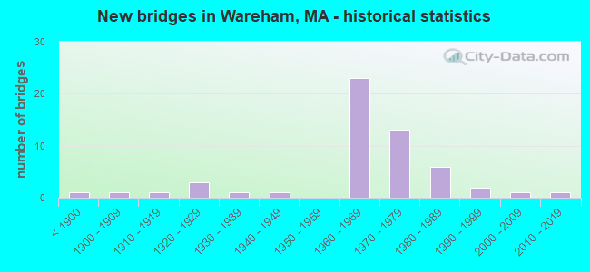
- New bridges - historical statistics
- 1Before 1900
- 11900-1909
- 11910-1919
- 31920-1929
- 11930-1939
- 11940-1949
- 231960-1969
- 131970-1979
- 61980-1989
- 21990-1999
- 12000-2009
- 12010-2019

- Reconstructed bridges - Historical Statistics
- 21920-1929
- 11930-1939
- 01940-1949
- 11950-1959
- 01960-1969
- 01970-1979
- 01980-1989
- 11990-1999


- Bridge Condition - Deck
- 57.9%Good
- 26.3%Satisfactory
- 15.8%Fair

- Bridge Condition - Superstructure
- 38.5%Good
- 41.0%Satisfactory
- 20.5%Fair

- Bridge Condition - Substructure
- 2.6%Very good
- 61.5%Good
- 25.6%Satisfactory
- 5.1%Fair
- 2.6%Poor
- 2.6%Serious

- Bridge Condition - Channel
- 9.5%Very good
- 52.4%Good
- 28.6%Satisfactory
- 4.8%Fair
- 4.8%Poor
Find on map >> Show street view
Structure Number: W0600145JDOTNBI, Location: .1 MI E OF MAIN ST (Lat: 41.756817, Lng: -70.712450), Route carried "on" structure: US 6, Year Built: 1992, Status: Open, Structure Length: 5.77m (18.93ft), Average Daily Traffic: 28,100 (year 2021), Truck Traffic: 2%, Average Future Daily Traffic: 64,751 (year 2032), Design Load: HS 20, Features Intersected: WATER WAREHAM RIVER
Minimum Vertical Clearance: 30+ m (98+ ft), Kilometerpoint: 4.426, Lanes on structure: 3, Owner: State Highway Agency, Approaching Roadway Width: 13.4m (44.0ft), Skew: 9 degrees, Material/Design: Steel continuous, Design/Construction: Stringer/Multi-beam, Number Of Spans In Main Unit: 3, Length of Maximum Span: 20.2m (66.3ft), Curb or Sidewalk Widths: Left: 1.5m (4.9ft), Right: 1.5m (4.9ft), Curb-To-Curb Width: 13.4m (44.0ft), Out-to-Out Width: 17.7m (58.1ft)
Condition: Deck: Good, Superstructure: Good, Substructure: Satisfactory, Channel: Satisfactory, Operating Rating: 68.8 metric tons, Method Used To Determine Operating Rating: Load Factor (LF), Inventory Rating: 41.2 metric tons, Method Used To Determine Inventory Rating: Load Factor (LF), Structural Evaluation: Equal to present minimum criteria, Deck Geometry: Somewhat better than minimum adequacy, Waterway Adequacy: Better than present minimum criteria, Approach Roadway Alignment: Equal to present desirable criteria, Length Of Structure Improvement: 5.80m (19.03ft), Designated Inspection Frequency: Every 24 months, Critical Feature Inspection Frequency: Every 24 months, Underwater Inspection Frequency: Every 36 months, Inspection Date: May 2021, Critical Feature Inspection Date: May 2021, Underwater Inspection Date: June 2019, Bridge Improvement Cost: $2,735,000, Roadway Improvement Cost: $274,000, Total Project Cost: $4,103,000 ( Estimate for 2022), Deck Structure Type: Concrete Cast-file-Place, Wearing Surface/Protective System: Wearing Surface: Bituminous, Membrane: Built-up, Deck Protection: Epoxy Coated Reinforcing
Find on map >> Show street view
Structure Number: W06002BP0MUNNBI, Location: .2M NW OF MAIN ST. (Lat: 41.779958, Lng: -70.763067), Route carried "on" structure: City street , Year Built: 2017, Status: Open, Structure Length: 1.18m (3.87ft), Average Daily Traffic: 775 (year 2021), Design Load: HL 93, Features Intersected: WATER WEWEANTIC RIVER, Facility Carried by Structure: HWY PAPER MLL RD
Minimum Vertical Clearance: 30+ m (98+ ft), Kilometerpoint: 0.000, Lanes on structure: 2, Owner: Town or Township Highway Agency, Approaching Roadway Width: 11.7m (38.4ft), Skew: 2 degrees, Material/Design: Concrete, Design/Construction: Frame, Number Of Spans In Main Unit: 1, Length of Maximum Span: 11.0m (36.1ft), Curb or Sidewalk Widths: Left: 0.2m (0.7ft), Right: 0.2m (0.7ft), Curb-To-Curb Width: 9.1m (29.9ft), Out-to-Out Width: 11.7m (38.4ft)
Condition: Deck: Good, Superstructure: Good, Substructure: Very good, Channel: Very good, Operating Rating: 42.1 metric tons, Method Used To Determine Operating Rating: Assigned ratings based on Load and Resistance Factor Design (LRFD) reported by rating factor (RF) using HL93 loadings, Inventory Rating: 32.4 metric tons, Method Used To Determine Inventory Rating: Assigned ratings based on Load and Resistance Factor Design (LRFD) reported by rating factor (RF) using HL93 loadings, Structural Evaluation: Better than present minimum criteria, Deck Geometry: Equal to present minimum criteria, Waterway Adequacy: Superior to present desirable criteria, Approach Roadway Alignment: Superior to present desirable criteria, Designated Inspection Frequency: Every 24 months, Inspection Date: August 2021, Deck Structure Type: Concrete Precast Panels, Wearing Surface/Protective System: Wearing Surface: Bituminous, Membrane: Built-up, Deck Protection: Epoxy Coated Reinforcing
Find on map >> Show street view
Structure Number: W060034AMDOTNBI, Location: 0.5 M E OF ROCHESTER TL (Lat: 41.798508, Lng: -70.763561), Route carried "on" structure: State highway 28, Year Built: 1923, Year Reconstructed: 1932, Status: Open, Structure Length: 0.82m (2.69ft), Average Daily Traffic: 20,300 (year 2020), Truck Traffic: 9%, Average Future Daily Traffic: 23,690 (year 2031), Design Load: H 20, Features Intersected: WATER WEWEANTIC RIVER
Minimum Vertical Clearance: 30+ m (98+ ft), Kilometerpoint: 118.943, Lanes on structure: 2, Owner: State Highway Agency, Approaching Roadway Width: 12.2m (40.0ft), Material/Design: Concrete, Design/Construction: Tee Beam, Number Of Spans In Main Unit: 1, Length of Maximum Span: 7.6m (24.9ft), Curb-To-Curb Width: 14.0m (45.9ft), Out-to-Out Width: 14.7m (48.2ft)
Condition: Deck: Good, Superstructure: Good, Substructure: Satisfactory, Channel: Satisfactory, Operating Rating: 57.6 metric tons, Method Used To Determine Operating Rating: Load Factor (LF), Inventory Rating: 34.5 metric tons, Method Used To Determine Inventory Rating: Load Factor (LF), Structural Evaluation: Equal to present minimum criteria, Deck Geometry: Superior to present desirable criteria, Waterway Adequacy: Equal to present desirable criteria, Approach Roadway Alignment: Equal to present desirable criteria, Length Of Structure Improvement: 0.90m (2.95ft), Designated Inspection Frequency: Every 24 months, Underwater Inspection Frequency: Every 36 months, Inspection Date: October 2020, Underwater Inspection Date: April 2020, Bridge Improvement Cost: $104,000, Roadway Improvement Cost: $11,000, Total Project Cost: $157,000 ( Estimate for 2022), Deck Structure Type: Concrete Cast-file-Place, Wearing Surface/Protective System: Wearing Surface: Bituminous, Membrane: Built-up
Find on map >> Show street view
Structure Number: W06004448MUNNBI, Location: .8 MI SE OF ROCHESTER (Lat: 41.791167, Lng: -70.764222), Route carried "on" structure: City street , Year Built: 1978, Status: Open, Structure Length: 0.61m (2.00ft), Average Daily Traffic: 3,600 (year 2019), Truck Traffic: 6%, Average Future Daily Traffic: 2,843 (year 2032), Design Load: H 20, Features Intersected: WATER WEWEANTIC RIVER, Facility Carried by Structure: HWY MAIN ST
Minimum Vertical Clearance: 30+ m (98+ ft), Kilometerpoint: 1.448, Lanes on structure: 2, Owner: Town or Township Highway Agency, Approaching Roadway Width: 7.9m (25.9ft), Material/Design: Steel, Design/Construction: Culvert, Number Of Spans In Main Unit: 1, Length of Maximum Span: 6.0m (19.7ft), Curb or Sidewalk Widths: Left: 0.0m, Right: 1.8m (5.9ft)
Condition: Channel: Good, Culverts: Fair, Structural Evaluation: Somewhat better than minimum adequacy, Waterway Adequacy: Equal to present desirable criteria, Approach Roadway Alignment: Equal to present desirable criteria, Length Of Structure Improvement: 0.80m (2.62ft), Designated Inspection Frequency: Every 24 months, Underwater Inspection Frequency: Every 24 months, Inspection Date: May 2021, Underwater Inspection Date: September 2020, Bridge Improvement Cost: $192,000, Roadway Improvement Cost: $20,000, Total Project Cost: $289,000 ( Estimate for 2022)
Find on map >> Show street view
Structure Number: W0600642EMUNNBI, Location: JUST N OF HORSESHOE POND (Lat: 41.770064, Lng: -70.754408), Route carried "on" structure: City street , Year Built: 1900, Year Reconstructed: 1930, Status: Posted for load, Structure Length: 0.85m (2.79ft), Average Daily Traffic: 5,142 (year 2021), Truck Traffic: 8%, Average Future Daily Traffic: 10,265 (year 2032), Features Intersected: WATER WEWEANTIC RIVER, Facility Carried by Structure: HWY FEARING HILL
Minimum Vertical Clearance: 30+ m (98+ ft), Kilometerpoint: 1.979, Lanes on structure: 2, Owner: Town or Township Highway Agency, Approaching Roadway Width: 9.2m (30.2ft), Material/Design: Steel, Design/Construction: Stringer/Multi-beam, Number Of Spans In Main Unit: 2, Length of Maximum Span: 3.8m (12.5ft), Curb or Sidewalk Widths: Left: 0.2m (0.7ft), Right: 0.2m (0.7ft), Curb-To-Curb Width: 9.2m (30.2ft), Out-to-Out Width: 10.3m (33.8ft)
Condition: Deck: Fair, Superstructure: Fair, Substructure: Serious, Channel: Fair, Operating Rating: 42.3 metric tons, Method Used To Determine Operating Rating: Load Factor (LF), Inventory Rating: 25.4 metric tons, Method Used To Determine Inventory Rating: Load Factor (LF), Structural Evaluation: High priority of corrective action, Deck Geometry: High priority of corrective action, Waterway Adequacy: Equal to present minimum criteria, Approach Roadway Alignment: Equal to present minimum criteria, Length Of Structure Improvement: 1.60m (5.25ft), Designated Inspection Frequency: Every 6 months, Underwater Inspection Frequency: Every 36 months, Other Special Inspection Frequency: Every 6 months, Inspection Date: September 2021, Underwater Inspection Date: October 2019, Other Special Inspection Date: March 2022, Bridge Improvement Cost: $1,216,000, Roadway Improvement Cost: $122,000, Total Project Cost: $1,825,000 ( Estimate for 2022), Deck Structure Type: Concrete Cast-file-Place, Wearing Surface/Protective System: Wearing Surface: Bituminous
Find on map >> Show street view
Structure Number: W060084C4DOT634, Location: .6 MI E OF COUNTY RD (Lat: 41.791256, Lng: -70.769764), Route carried "on" structure: City street , Year Built: 1887, Year Reconstructed: 1996, Status: Closed, Structure Length: 1.92m (6.30ft), Average Daily Traffic: 390 (year 2022), Truck Traffic: 6%, Average Future Daily Traffic: 2,527 (year 2032), Design Load: HS 20, Features Intersected: RR MACRR, Facility Carried by Structure: HWY PIERCEVLE RD
Minimum Vertical Clearance: 30+ m (98+ ft), Kilometerpoint: 2.092, Lanes on structure: 2, Owner: State Highway Agency, Approaching Roadway Width: 5.5m (18.0ft), Material/Design: Steel, Design/Construction: Truss - Thru, Number Of Spans In Main Unit: 1, Length of Maximum Span: 16.5m (54.1ft), Curb-To-Curb Width: 6.7m (22.0ft), Out-to-Out Width: 7.6m (24.9ft)
Condition: Deck: Good, Superstructure: Fair, Substructure: Good, Operating Rating: 7.7 metric tons, Method Used To Determine Operating Rating: Load Factor (LF), Inventory Rating: 4.6 metric tons, Method Used To Determine Inventory Rating: Load Factor (LF), Deck Geometry: Meets minimum limits, Approach Roadway Alignment: Somewhat better than minimum adequacy, Bridge Posting: Required (Relationship of Operating Rating to Maximum Legal Load: > 39.9% below), Length Of Structure Improvement: 2.00m (6.56ft), Designated Inspection Frequency: Every 11 months, Critical Feature Inspection Frequency: Every 24 months, Inspection Date: December 2021, Critical Feature Inspection Date: December 2021, Bridge Improvement Cost: $598,000, Roadway Improvement Cost: $60,000, Total Project Cost: $898,000 ( Estimate for 2022), Deck Structure Type: Concrete Cast-file-Place, Wearing Surface/Protective System: Wearing Surface: Bituminous, Membrane: Built-up, Deck Protection: Epoxy Coated Reinforcing
Find on map >> Show street view
Structure Number: W060094C5DOT634, Location: .3 MI N OF PAPERMILL RD (Lat: 41.782256, Lng: -70.758169), Route carried "on" structure: City street , Year Built: 1988, Status: Open, Structure Length: 2.38m (7.81ft), Average Daily Traffic: 3,200 (year 2019), Truck Traffic: 6%, Average Future Daily Traffic: 2,843 (year 2033), Design Load: HS 20, Features Intersected: RR MACRR, Facility Carried by Structure: HWY MAIN ST
Minimum Vertical Clearance: 30+ m (98+ ft), Kilometerpoint: 2.575, Lanes on structure: 2, Owner: State Highway Agency, Approaching Roadway Width: 11.0m (36.1ft), Skew: 5 degrees, Material/Design: Steel, Design/Construction: Stringer/Multi-beam, Number Of Spans In Main Unit: 1, Length of Maximum Span: 23.2m (76.1ft), Curb or Sidewalk Widths: Left: 1.5m (4.9ft), Right: 0.2m (0.7ft), Curb-To-Curb Width: 10.3m (33.8ft), Out-to-Out Width: 13.1m (43.0ft)
Condition: Deck: Good, Superstructure: Good, Substructure: Good, Operating Rating: 65.1 metric tons, Method Used To Determine Operating Rating: Load Factor (LF), Inventory Rating: 39.0 metric tons, Method Used To Determine Inventory Rating: Load Factor (LF), Structural Evaluation: Better than present minimum criteria, Deck Geometry: Meets minimum limits, Underclear: High priority of corrective action, Approach Roadway Alignment: Better than present minimum criteria, Length Of Structure Improvement: 2.40m (7.87ft), Designated Inspection Frequency: Every 24 months, Inspection Date: January 2022, Bridge Improvement Cost: $702,000, Roadway Improvement Cost: $71,000, Total Project Cost: $1,054,000 ( Estimate for 2022), Deck Structure Type: Concrete Cast-file-Place, Wearing Surface/Protective System: Wearing Surface: Bituminous, Membrane: Built-up, Deck Protection: Epoxy Coated Reinforcing
Find on map >> Show street view
Structure Number: W060114C6DOT634, Location: 0.7 M S OF RTE 195 (Lat: 41.767144, Lng: -70.729694), Route carried "on" structure: City street , Year Built: 1985, Status: Open, Structure Length: 1.98m (6.50ft), Average Daily Traffic: 26,600 (year 2020), Truck Traffic: 5%, Average Future Daily Traffic: 37,114 (year 2033), Design Load: HS 20, Features Intersected: RR MACRR, Facility Carried by Structure: HWY MAIN ST
Minimum Vertical Clearance: 30+ m (98+ ft), Kilometerpoint: 11.426, Lanes on structure: 2, Owner: State Highway Agency, Approaching Roadway Width: 12.2m (40.0ft), Skew: 5 degrees, Material/Design: Steel, Design/Construction: Stringer/Multi-beam, Number Of Spans In Main Unit: 1, Length of Maximum Span: 19.2m (63.0ft), Curb or Sidewalk Widths: Left: 1.6m (5.2ft), Right: 1.6m (5.2ft), Curb-To-Curb Width: 12.2m (40.0ft), Out-to-Out Width: 16.1m (52.8ft)
Condition: Deck: Good, Superstructure: Good, Substructure: Good, Operating Rating: 73.3 metric tons, Method Used To Determine Operating Rating: Load Factor (LF), Inventory Rating: 43.9 metric tons, Method Used To Determine Inventory Rating: Load Factor (LF), Structural Evaluation: Better than present minimum criteria, Deck Geometry: Somewhat better than minimum adequacy, Underclear: High priority of corrective action, Approach Roadway Alignment: Equal to present desirable criteria, Length Of Structure Improvement: 2.00m (6.56ft), Designated Inspection Frequency: Every 24 months, Inspection Date: January 2022, Bridge Improvement Cost: $227,000, Roadway Improvement Cost: $23,000, Total Project Cost: $341,000 ( Estimate for 2022), Deck Structure Type: Concrete Cast-file-Place, Wearing Surface/Protective System: Wearing Surface: Bituminous, Membrane: Built-up, Deck Protection: Cathodic Protection
Find on map >> Show street view
Structure Number: W060144A0DOTNBI, Location: 0.5 MI W OF RTE 6 & 28 (Lat: 41.742567, Lng: -70.653664), Route carried "on" structure: City street , Year Built: 1914, Status: Open, Structure Length: 8.56m (28.08ft), Average Daily Traffic: 13,500 (year 2016), Truck Traffic: 6%, Average Future Daily Traffic: 21,321 (year 2031), Features Intersected: WATER EAST RIVER, Facility Carried by Structure: HWY ONSET AVE
Minimum Vertical Clearance: 30+ m (98+ ft), Kilometerpoint: 2.655, Lanes on structure: 2, Owner: State Highway Agency, Approaching Roadway Width: 9.4m (30.8ft), Material/Design: Concrete, Design/Construction: Arch - Deck, Number Of Spans In Main Unit: 3, Length of Maximum Span: 28.7m (94.2ft), Curb or Sidewalk Widths: Left: 0.0m, Right: 1.8m (5.9ft), Curb-To-Curb Width: 10.8m (35.4ft), Out-to-Out Width: 14.3m (46.9ft)
Condition: Superstructure: Fair, Substructure: Fair, Channel: Satisfactory, Operating Rating: 57.0 metric tons, Method Used To Determine Operating Rating: Load Factor (LF), Inventory Rating: 50.0 metric tons, Method Used To Determine Inventory Rating: Load Factor (LF), Structural Evaluation: Somewhat better than minimum adequacy, Deck Geometry: Meets minimum limits, Waterway Adequacy: Equal to present desirable criteria, Approach Roadway Alignment: Better than present minimum criteria, Length Of Structure Improvement: 8.60m (28.22ft), Designated Inspection Frequency: Every 24 months, Underwater Inspection Frequency: Every 36 months, Inspection Date: June 2020, Underwater Inspection Date: Febuary 2021, Bridge Improvement Cost: $4,831,000, Roadway Improvement Cost: $484,000, Total Project Cost: $7,247,000 ( Estimate for 2022)
Find on map >> Show street view
Structure Number: W060154C3DOT634, Location: MACRR MP 53.98 (Lat: 41.748661, Lng: -70.627294), Route carried "on" structure: City street , Year Built: 1990, Status: Open, Structure Length: 1.54m (5.05ft), Average Daily Traffic: 4,866 (year 2019), Truck Traffic: 4%, Average Future Daily Traffic: 17,056 (year 2031), Design Load: HS 20, Features Intersected: RR MACRR, Facility Carried by Structure: HWY ONSET AVE
Minimum Vertical Clearance: 30+ m (98+ ft), Kilometerpoint: 5.150, Lanes on structure: 2, Owner: State Highway Agency, Approaching Roadway Width: 8.5m (27.9ft), Skew: 2 degrees, Material/Design: Steel, Design/Construction: Stringer/Multi-beam, Number Of Spans In Main Unit: 1, Length of Maximum Span: 13.4m (44.0ft), Curb or Sidewalk Widths: Left: 1.5m (4.9ft), Right: 0.2m (0.7ft), Curb-To-Curb Width: 8.5m (27.9ft), Out-to-Out Width: 11.1m (36.4ft)
Condition: Deck: Good, Superstructure: Good, Substructure: Good, Operating Rating: 70.3 metric tons, Method Used To Determine Operating Rating: Load Factor (LF), Inventory Rating: 42.1 metric tons, Method Used To Determine Inventory Rating: Load Factor (LF), Structural Evaluation: Better than present minimum criteria, Deck Geometry: Meets minimum limits, Underclear: High priority of corrective action, Approach Roadway Alignment: Better than present minimum criteria, Length Of Structure Improvement: 1.60m (5.25ft), Designated Inspection Frequency: Every 24 months, Inspection Date: November 2020, Bridge Improvement Cost: $740,000, Roadway Improvement Cost: $75,000, Total Project Cost: $1,111,000 ( Estimate for 2022), Deck Structure Type: Concrete Cast-file-Place, Wearing Surface/Protective System: Wearing Surface: Bituminous, Membrane: Built-up, Deck Protection: Epoxy Coated Reinforcing
Find on map >> Show street view
Structure Number: W0601645KDOTNBI, Location: 2 MI E OF RTE 105 (Lat: 41.738628, Lng: -70.746083), Route carried "on" structure: US 6, Year Built: 1929, Year Reconstructed: 1957, Status: Open, Structure Length: 4.52m (14.83ft), Average Daily Traffic: 9,600 (year 2019), Truck Traffic: 5%, Average Future Daily Traffic: 23,690 (year 2031), Design Load: H 20, Features Intersected: WATER WEWEANTIC RIVER
Minimum Vertical Clearance: 30+ m (98+ ft), Kilometerpoint: 66.097, Lanes on structure: 4, Owner: State Highway Agency, Approaching Roadway Width: 13.5m (44.3ft), Material/Design: Concrete continuous, Design/Construction: Tee Beam, Number Of Spans In Main Unit: 3, Length of Maximum Span: 15.7m (51.5ft), Curb or Sidewalk Widths: Left: 1.8m (5.9ft), Right: 1.8m (5.9ft), Curb-To-Curb Width: 13.5m (44.3ft), Out-to-Out Width: 17.9m (58.7ft)
Condition: Deck: Fair, Superstructure: Fair, Substructure: Poor, Channel: Poor, Operating Rating: 42.3 metric tons, Method Used To Determine Operating Rating: Allowable Stress (AS), Inventory Rating: 23.6 metric tons, Method Used To Determine Inventory Rating: Allowable Stress (AS), Structural Evaluation: Meets minimum limits, Deck Geometry: High priority of replacement, Waterway Adequacy: Equal to present desirable criteria, Approach Roadway Alignment: Equal to present desirable criteria, Length Of Structure Improvement: 5.60m (18.37ft), Designated Inspection Frequency: Every 12 months, Underwater Inspection Frequency: Every 12 months, Inspection Date: October 2020, Underwater Inspection Date: April 2021, Bridge Improvement Cost: $7,774,000, Roadway Improvement Cost: $778,000, Total Project Cost: $11,662,000 ( Estimate for 2022), Deck Structure Type: Concrete Cast-file-Place, Wearing Surface/Protective System: Wearing Surface: Bituminous, Membrane: Built-up
Find on map >> Show street view
Structure Number: W06017AW9MUNNBI, Location: .7 MI SW OF RTE 6 (Lat: 41.747867, Lng: -70.656122), Route carried "on" structure: City street , Year Built: 2005, Status: Open, Structure Length: 3.44m (11.29ft), Average Daily Traffic: 7,700 (year 2016), Truck Traffic: 6%, Average Future Daily Traffic: 12,161 (year 2031), Design Load: HS 20, Features Intersected: WATER EAST RIVER, Facility Carried by Structure: HWY MAIN AVE
Minimum Vertical Clearance: 30+ m (98+ ft), Kilometerpoint: 0.322, Lanes on structure: 2, Owner: Town or Township Highway Agency, Approaching Roadway Width: 12.2m (40.0ft), Material/Design: Prestressed concrete, Design/Construction: Box Beam or Girders - Single/Spread, Number Of Spans In Main Unit: 1, Length of Maximum Span: 33.3m (109.3ft), Curb or Sidewalk Widths: Left: 1.8m (5.9ft), Right: 1.8m (5.9ft), Curb-To-Curb Width: 12.2m (40.0ft), Out-to-Out Width: 16.6m (54.5ft)
Condition: Deck: Good, Superstructure: Good, Substructure: Good, Channel: Very good, Inventory Rating: 53.0 metric tons, Method Used To Determine Inventory Rating: Load Factor (LF), Structural Evaluation: Better than present minimum criteria, Deck Geometry: Somewhat better than minimum adequacy, Waterway Adequacy: Better than present minimum criteria, Approach Roadway Alignment: Equal to present desirable criteria, Length Of Structure Improvement: 3.50m (11.48ft), Designated Inspection Frequency: Every 24 months, Inspection Date: June 2020, Bridge Improvement Cost: $396,000, Roadway Improvement Cost: $40,000, Total Project Cost: $595,000 ( Estimate for 2022), Deck Structure Type: Concrete Cast-file-Place, Wearing Surface/Protective System: Wearing Surface: Monolithic Concrete, Deck Protection: Epoxy Coated Reinforcing
Find on map >> Show street view
Structure Number: W0601845HDOTNBI, Location: 1.3 M E OF NARROWS RD (Lat: 41.763517, Lng: -70.688728), Route carried "on" structure: US 6, Year Built: 1930, Status: Open, Structure Length: 1.10m (3.61ft), Average Daily Traffic: 9,210 (year 2017), Truck Traffic: 1%, Average Future Daily Traffic: 19,425 (year 2031), Design Load: H 20, Features Intersected: WATER AGAWAM RIVER
Minimum Vertical Clearance: 30+ m (98+ ft), Kilometerpoint: 73.151, Lanes on structure: 2, Owner: State Highway Agency, Approaching Roadway Width: 9.4m (30.8ft), Skew: 1 degrees, Material/Design: Concrete, Design/Construction: Tee Beam, Number Of Spans In Main Unit: 1, Length of Maximum Span: 9.4m (30.8ft), Curb or Sidewalk Widths: Left: 1.6m (5.2ft), Right: 1.6m (5.2ft), Curb-To-Curb Width: 9.2m (30.2ft), Out-to-Out Width: 13.6m (44.6ft)
Condition: Deck: Satisfactory, Superstructure: Fair, Substructure: Satisfactory, Channel: Satisfactory, Operating Rating: 62.3 metric tons, Method Used To Determine Operating Rating: Load Factor (LF), Inventory Rating: 37.5 metric tons, Method Used To Determine Inventory Rating: Load Factor (LF), Structural Evaluation: Somewhat better than minimum adequacy, Deck Geometry: High priority of corrective action, Waterway Adequacy: Equal to present desirable criteria, Approach Roadway Alignment: Equal to present desirable criteria, Length Of Structure Improvement: 1.20m (3.94ft), Designated Inspection Frequency: Every 24 months, Underwater Inspection Frequency: Every 36 months, Inspection Date: August 2020, Underwater Inspection Date: August 2020, Bridge Improvement Cost: $642,000, Roadway Improvement Cost: $65,000, Total Project Cost: $964,000 ( Estimate for 2022), Deck Structure Type: Concrete Cast-file-Place, Wearing Surface/Protective System: Wearing Surface: Bituminous
Find on map >> Show street view
Structure Number: W060194ALDOTNBI, Location: 1 MI S OF RTE 195 (Lat: 41.767628, Lng: -70.722758), Route carried "on" structure: State highway 28, Year Built: 1924, Year Reconstructed: 1932, Status: Open, Structure Length: 1.07m (3.51ft), Average Daily Traffic: 12,400 (year 2019), Truck Traffic: 7%, Average Future Daily Traffic: 41,220 (year 2031), Design Load: H 20, Features Intersected: WATER PARKER MILL POND
Minimum Vertical Clearance: 30+ m (98+ ft), Kilometerpoint: 113.874, Lanes on structure: 2, Owner: State Highway Agency, Approaching Roadway Width: 12.2m (40.0ft), Material/Design: Concrete, Design/Construction: Tee Beam, Number Of Spans In Main Unit: 1, Length of Maximum Span: 9.1m (29.9ft), Curb-To-Curb Width: 14.0m (45.9ft), Out-to-Out Width: 14.8m (48.6ft)
Condition: Deck: Satisfactory, Superstructure: Fair, Substructure: Fair, Channel: Good, Operating Rating: 58.5 metric tons, Method Used To Determine Operating Rating: Load Factor (LF), Inventory Rating: 35.1 metric tons, Method Used To Determine Inventory Rating: Load Factor (LF), Structural Evaluation: Somewhat better than minimum adequacy, Deck Geometry: Superior to present desirable criteria, Waterway Adequacy: Equal to present desirable criteria, Approach Roadway Alignment: Equal to present desirable criteria, Length Of Structure Improvement: 1.10m (3.61ft), Designated Inspection Frequency: Every 24 months, Underwater Inspection Frequency: Every 36 months, Inspection Date: June 2020, Underwater Inspection Date: Febuary 2019, Bridge Improvement Cost: $640,000, Roadway Improvement Cost: $65,000, Total Project Cost: $961,000 ( Estimate for 2022), Deck Structure Type: Concrete Cast-file-Place, Wearing Surface/Protective System: Wearing Surface: Bituminous
Find on map >> Show street view
Structure Number: W060294AEDOTNBI, Location: .2 MI W OF DEPOT ST (Lat: 41.761431, Lng: -70.677289), Route carried "on" structure: US 6, Year Built: 1949, Status: Open, Structure Length: 0.76m (2.49ft), Average Daily Traffic: 21,400 (year 2019), Truck Traffic: 4%, Average Future Daily Traffic: 45,800 (year 2031), Design Load: H 20, Features Intersected: WATER AGAWAM RIVER
Minimum Vertical Clearance: 30+ m (98+ ft), Kilometerpoint: 74.189, Lanes on structure: 2, Owner: State Highway Agency, Approaching Roadway Width: 12.2m (40.0ft), Skew: 2 degrees, Material/Design: Concrete, Design/Construction: Tee Beam, Number Of Spans In Main Unit: 1, Length of Maximum Span: 6.7m (22.0ft), Curb or Sidewalk Widths: Left: 0.0m, Right: 1.5m (4.9ft), Curb-To-Curb Width: 10.7m (35.1ft), Out-to-Out Width: 38.5m (126.3ft)
Condition: Deck: Good, Superstructure: Good, Substructure: Good, Channel: Good, Structural Evaluation: Better than present minimum criteria, Deck Geometry: Somewhat better than minimum adequacy, Waterway Adequacy: Equal to present desirable criteria, Approach Roadway Alignment: Equal to present desirable criteria, Length Of Structure Improvement: 0.80m (2.62ft), Designated Inspection Frequency: Every 24 months, Inspection Date: June 2020, Bridge Improvement Cost: $160,000, Roadway Improvement Cost: $17,000, Total Project Cost: $241,000 ( Estimate for 2022), Deck Structure Type: Concrete Cast-file-Place, Wearing Surface/Protective System: Wearing Surface: Bituminous, Membrane: Built-up
Find on map >> Show street view
Structure Number: W0603349PDOTNBI, Location: .4 M N OF RTE 28 (Lat: 41.806306, Lng: -70.769511), Route carried "on" structure: State highway 58, Year Built: 1964, Status: Open, Structure Length: 6.74m (22.11ft), Average Daily Traffic: 20,301 (year 2019), Truck Traffic: 12%, Average Future Daily Traffic: 26,848 (year 2032), Design Load: H 20, Features Intersected: I 495
Minimum Vertical Clearance: 30+ m (98+ ft), Kilometerpoint: 0.692, Lanes on structure: 2, Lanes under structure: 6, Owner: State Highway Agency, Approaching Roadway Width: 13.7m (44.9ft), Material/Design: Steel, Design/Construction: Stringer/Multi-beam, Number Of Spans In Main Unit: 3, Length of Maximum Span: 23.8m (78.1ft), Curb or Sidewalk Widths: Left: 0.5m (1.6ft), Right: 1.5m (4.9ft), Curb-To-Curb Width: 13.4m (44.0ft), Out-to-Out Width: 16.1m (52.8ft)
Condition: Deck: Satisfactory, Superstructure: Satisfactory, Substructure: Satisfactory, Operating Rating: 47.5 metric tons, Method Used To Determine Operating Rating: Allowable Stress (AS), Inventory Rating: 24.9 metric tons, Method Used To Determine Inventory Rating: Allowable Stress (AS), Structural Evaluation: Equal to present minimum criteria, Deck Geometry: Equal to present minimum criteria, Underclear: High priority of corrective action, Approach Roadway Alignment: Equal to present desirable criteria, Length Of Structure Improvement: 6.80m (22.31ft), Designated Inspection Frequency: Every 24 months, Inspection Date: March 2021, Bridge Improvement Cost: $4,301,000, Roadway Improvement Cost: $431,000, Total Project Cost: $6,452,000 ( Estimate for 2022), Deck Structure Type: Concrete Cast-file-Place, Wearing Surface/Protective System: Wearing Surface: Bituminous, Membrane: Built-up
Find on map >> Show street view
Structure Number: W0603446BDOTNBI, Location: 0.5 M S OF RTE 58 (Lat: 41.800803, Lng: -70.761114), Route carried "on" structure: Interstate 495, Year Built: 1964, Status: Open, Structure Length: 2.35m (7.71ft), Average Daily Traffic: 23,000 (year 2019), Truck Traffic: 4%, Average Future Daily Traffic: 63,172 (year 2032), Design Load: H 20, Features Intersected: WATER WEWEANTIC RIVER
Minimum Vertical Clearance: 30+ m (98+ ft), Kilometerpoint: 3.057, Lanes on structure: 2, Base Highway Network: Yes, Owner: State Highway Agency, Approaching Roadway Width: 11.6m (38.1ft), Material/Design: Concrete continuous, Design/Construction: Slab, Number Of Spans In Main Unit: 3, Length of Maximum Span: 7.6m (24.9ft), Curb or Sidewalk Widths: Left: 0.5m (1.6ft), Right: 0.2m (0.7ft), Curb-To-Curb Width: 11.6m (38.1ft), Out-to-Out Width: 13.0m (42.7ft)
Condition: Deck: Good, Superstructure: Good, Substructure: Good, Channel: Good, Operating Rating: 47.3 metric tons, Method Used To Determine Operating Rating: Load Factor (LF), Inventory Rating: 28.3 metric tons, Method Used To Determine Inventory Rating: Load Factor (LF), Structural Evaluation: Better than present minimum criteria, Deck Geometry: Equal to present minimum criteria, Waterway Adequacy: Equal to present desirable criteria, Approach Roadway Alignment: Equal to present desirable criteria, Length Of Structure Improvement: 2.40m (7.87ft), Designated Inspection Frequency: Every 24 months, Underwater Inspection Frequency: Every 36 months, Inspection Date: May 2021, Underwater Inspection Date: April 2019, Bridge Improvement Cost: $1,226,000, Roadway Improvement Cost: $123,000, Total Project Cost: $1,840,000 ( Estimate for 2022), Deck Structure Type: Concrete Cast-file-Place, Wearing Surface/Protective System: Wearing Surface: Bituminous, Membrane: Built-up
Find on map >> Show street view
Structure Number: W0603446CDOTNBI, Location: 0.5 M S OF RTE 58 (Lat: 41.800550, Lng: -70.761431), Route carried "on" structure: Interstate 495, Year Built: 1964, Status: Open, Structure Length: 2.35m (7.71ft), Average Daily Traffic: 25,800 (year 2019), Truck Traffic: 1%, Average Future Daily Traffic: 63,172 (year 2032), Design Load: H 20, Features Intersected: WATER WEWEANTIC RIVER
Minimum Vertical Clearance: 30+ m (98+ ft), Kilometerpoint: 18.716, Lanes on structure: 2, Base Highway Network: Yes, Owner: State Highway Agency, Approaching Roadway Width: 11.6m (38.1ft), Material/Design: Concrete continuous, Design/Construction: Slab, Number Of Spans In Main Unit: 3, Length of Maximum Span: 7.6m (24.9ft), Curb or Sidewalk Widths: Left: 0.5m (1.6ft), Right: 0.0m, Curb-To-Curb Width: 11.6m (38.1ft), Out-to-Out Width: 13.0m (42.7ft)
Condition: Deck: Good, Superstructure: Good, Substructure: Good, Channel: Good, Operating Rating: 48.0 metric tons, Method Used To Determine Operating Rating: Load Factor (LF), Inventory Rating: 28.8 metric tons, Method Used To Determine Inventory Rating: Load Factor (LF), Structural Evaluation: Better than present minimum criteria, Deck Geometry: Equal to present minimum criteria, Waterway Adequacy: Equal to present desirable criteria, Approach Roadway Alignment: Equal to present desirable criteria, Length Of Structure Improvement: 2.40m (7.87ft), Designated Inspection Frequency: Every 24 months, Underwater Inspection Frequency: Every 36 months, Inspection Date: May 2021, Underwater Inspection Date: April 2019, Bridge Improvement Cost: $1,226,000, Roadway Improvement Cost: $123,000, Total Project Cost: $1,840,000 ( Estimate for 2022), Deck Structure Type: Concrete Cast-file-Place, Wearing Surface/Protective System: Wearing Surface: Bituminous, Membrane: Built-up
Find on map >> Show street view
Structure Number: W060354AHDOTNBI, Location: 0.2 M N OF RTE 6 & 28 WB (Lat: 41.765008, Lng: -70.671375), Route carried "on" structure: City street , Year Built: 1980, Status: Open, Structure Length: 7.19m (23.59ft), Average Daily Traffic: 5,825 (year 2019), Truck Traffic: 6%, Average Future Daily Traffic: 17,846 (year 2032), Design Load: H 20, Features Intersected: ST 25, Facility Carried by Structure: HWY GLEN CHRL RD
Minimum Vertical Clearance: 30+ m (98+ ft), Kilometerpoint: 0.000, Lanes on structure: 2, Lanes under structure: 6, Owner: State Highway Agency, Approaching Roadway Width: 13.7m (44.9ft), Material/Design: Steel continuous, Design/Construction: Stringer/Multi-beam, Number Of Spans In Main Unit: 2, Length of Maximum Span: 34.7m (113.8ft), Curb or Sidewalk Widths: Left: 1.5m (4.9ft), Right: 0.2m (0.7ft), Curb-To-Curb Width: 13.7m (44.9ft), Out-to-Out Width: 16.4m (53.8ft)
Condition: Deck: Fair, Superstructure: Good, Substructure: Good, Operating Rating: 53.8 metric tons, Method Used To Determine Operating Rating: Load Factor (LF), Inventory Rating: 32.2 metric tons, Method Used To Determine Inventory Rating: Load Factor (LF), Structural Evaluation: Better than present minimum criteria, Deck Geometry: Superior to present desirable criteria, Underclear: Equal to present minimum criteria, Approach Roadway Alignment: Equal to present desirable criteria, Length Of Structure Improvement: 7.20m (23.62ft), Designated Inspection Frequency: Every 24 months, Inspection Date: Febuary 2021, Bridge Improvement Cost: $4,639,000, Roadway Improvement Cost: $464,000, Total Project Cost: $6,959,000 ( Estimate for 2022), Deck Structure Type: Concrete Cast-file-Place, Wearing Surface/Protective System: Wearing Surface: Bituminous, Membrane: Built-up
Find on map >> Show street view
Structure Number: W06036465DOTNBI, Location: .1 M W OF GLEN CHARLIE RD (Lat: 41.765753, Lng: -70.674711), Route carried "on" structure: State highway 25, Year Built: 1981, Status: Open, Structure Length: 2.23m (7.32ft), Average Daily Traffic: 29,152 (year 2019), Truck Traffic: 5%, Average Future Daily Traffic: 49,669 (year 2032), Design Load: HS 20, Features Intersected: WATER MILL POND
Minimum Vertical Clearance: 30+ m (98+ ft), Kilometerpoint: 5.391, Lanes on structure: 3, Base Highway Network: Yes, Owner: State Highway Agency, Approaching Roadway Width: 15.2m (49.9ft), Material/Design: Concrete continuous, Design/Construction: Slab, Number Of Spans In Main Unit: 3, Length of Maximum Span: 7.6m (24.9ft), Curb-To-Curb Width: 16.5m (54.1ft), Out-to-Out Width: 17.4m (57.1ft)
Condition: Deck: Good, Superstructure: Good, Substructure: Good, Channel: Good, Inventory Rating: 61.0 metric tons, Method Used To Determine Inventory Rating: Load Factor (LF), Structural Evaluation: Better than present minimum criteria, Deck Geometry: Equal to present minimum criteria, Waterway Adequacy: Superior to present desirable criteria, Approach Roadway Alignment: Equal to present desirable criteria, Length Of Structure Improvement: 2.30m (7.55ft), Designated Inspection Frequency: Every 24 months, Underwater Inspection Frequency: Every 36 months, Inspection Date: June 2021, Underwater Inspection Date: March 2021, Bridge Improvement Cost: $413,000, Roadway Improvement Cost: $42,000, Total Project Cost: $620,000 ( Estimate for 2022), Deck Structure Type: Concrete Cast-file-Place, Wearing Surface/Protective System: Wearing Surface: Bituminous, Membrane: Built-up, Deck Protection: Cathodic Protection
Find on map >> Show street view
Structure Number: W06036466DOTNBI, Location: .1 M W OF GLEN CHARLIE RD (Lat: 41.766106, Lng: -70.674528), Route carried "on" structure: State highway 25, Year Built: 1987, Status: Open, Structure Length: 2.35m (7.71ft), Average Daily Traffic: 34,531 (year 2019), Truck Traffic: 3%, Average Future Daily Traffic: 49,669 (year 2032), Design Load: HS 20, Features Intersected: WATER MILL POND
Minimum Vertical Clearance: 30+ m (98+ ft), Kilometerpoint: 5.391, Lanes on structure: 3, Base Highway Network: Yes, Owner: State Highway Agency, Approaching Roadway Width: 15.2m (49.9ft), Material/Design: Concrete continuous, Design/Construction: Slab, Number Of Spans In Main Unit: 3, Length of Maximum Span: 7.6m (24.9ft), Curb-To-Curb Width: 16.5m (54.1ft), Out-to-Out Width: 17.4m (57.1ft)
Condition: Deck: Good, Superstructure: Good, Substructure: Good, Channel: Good, Operating Rating: 67.8 metric tons, Method Used To Determine Operating Rating: Load Factor (LF), Inventory Rating: 40.6 metric tons, Method Used To Determine Inventory Rating: Load Factor (LF), Structural Evaluation: Better than present minimum criteria, Deck Geometry: Equal to present minimum criteria, Waterway Adequacy: Superior to present desirable criteria, Approach Roadway Alignment: Equal to present desirable criteria, Length Of Structure Improvement: 2.40m (7.87ft), Designated Inspection Frequency: Every 24 months, Underwater Inspection Frequency: Every 36 months, Inspection Date: June 2021, Underwater Inspection Date: March 2021, Bridge Improvement Cost: $430,000, Roadway Improvement Cost: $44,000, Total Project Cost: $646,000 ( Estimate for 2022), Deck Structure Type: Concrete Cast-file-Place, Wearing Surface/Protective System: Wearing Surface: Bituminous, Membrane: Built-up, Deck Protection: Cathodic Protection
Find on map >> Show street view
Structure Number: W060374AJDOTNBI, Location: 1.5 M E OF CHARGE PND RD (Lat: 41.767758, Lng: -70.680444), Route carried "on" structure: City street , Year Built: 1980, Status: Open, Structure Length: 7.32m (24.02ft), Average Daily Traffic: 9,100 (year 2017), Truck Traffic: 7%, Average Future Daily Traffic: 15,477 (year 2032), Design Load: H 20, Features Intersected: ST 25, Facility Carried by Structure: HWY MAPLE SPRING
Minimum Vertical Clearance: 30+ m (98+ ft), Kilometerpoint: 0.322, Lanes on structure: 3, Lanes under structure: 7, Owner: State Highway Agency, Approaching Roadway Width: 14.6m (47.9ft), Material/Design: Steel, Design/Construction: Stringer/Multi-beam, Number Of Spans In Main Unit: 2, Length of Maximum Span: 36.6m (120.1ft), Curb or Sidewalk Widths: Left: 0.2m (0.7ft), Right: 1.5m (4.9ft), Curb-To-Curb Width: 14.9m (48.9ft), Out-to-Out Width: 17.5m (57.4ft)
Condition: Deck: Satisfactory, Superstructure: Satisfactory, Substructure: Satisfactory, Operating Rating: 62.3 metric tons, Method Used To Determine Operating Rating: Load Factor (LF), Inventory Rating: 37.3 metric tons, Method Used To Determine Inventory Rating: Load Factor (LF), Structural Evaluation: Equal to present minimum criteria, Deck Geometry: Equal to present minimum criteria, Underclear: Equal to present minimum criteria, Approach Roadway Alignment: Equal to present desirable criteria, Length Of Structure Improvement: 7.40m (24.28ft), Designated Inspection Frequency: Every 24 months, Inspection Date: March 2021, Bridge Improvement Cost: $2,442,000, Roadway Improvement Cost: $245,000, Total Project Cost: $3,664,000 ( Estimate for 2022), Deck Structure Type: Concrete Cast-file-Place, Wearing Surface/Protective System: Wearing Surface: Bituminous, Membrane: Built-up
Find on map >> Show street view
Structure Number: W060384BDDOTNBI, Location: 0.7 M E OF ELM ST (Lat: 41.776244, Lng: -70.707358), Route carried "on" structure: City street , Year Built: 1967, Status: Open, Structure Length: 9.27m (30.41ft), Average Daily Traffic: 1,100 (year 2019), Truck Traffic: 6%, Average Future Daily Traffic: 4,106 (year 2032), Design Load: H 20, Features Intersected: ST 25, Facility Carried by Structure: HWY CHRGE PND RD
Minimum Vertical Clearance: 30+ m (98+ ft), Kilometerpoint: 0.000, Lanes on structure: 2, Lanes under structure: 6, Owner: State Highway Agency, Approaching Roadway Width: 8.5m (27.9ft), Skew: 4 degrees, Material/Design: Steel, Design/Construction: Stringer/Multi-beam, Number Of Spans In Main Unit: 3, Length of Maximum Span: 33.5m (109.9ft), Curb or Sidewalk Widths: Left: 1.5m (4.9ft), Right: 0.5m (1.6ft), Curb-To-Curb Width: 8.5m (27.9ft), Out-to-Out Width: 11.4m (37.4ft)
Condition: Deck: Fair, Superstructure: Satisfactory, Substructure: Satisfactory, Operating Rating: 57.4 metric tons, Method Used To Determine Operating Rating: Load Factor (LF), Inventory Rating: 34.4 metric tons, Method Used To Determine Inventory Rating: Load Factor (LF), Structural Evaluation: Equal to present minimum criteria, Deck Geometry: Somewhat better than minimum adequacy, Underclear: High priority of corrective action, Approach Roadway Alignment: Equal to present desirable criteria, Length Of Structure Improvement: 9.30m (30.51ft), Designated Inspection Frequency: Every 24 months, Inspection Date: April 2021, Bridge Improvement Cost: $7,628,000, Roadway Improvement Cost: $763,000, Total Project Cost: $11,443,000 ( Estimate for 2022), Deck Structure Type: Concrete Cast-file-Place, Wearing Surface/Protective System: Wearing Surface: Bituminous, Membrane: Built-up
Find on map >> Show street view
Structure Number: W06039467DOTNBI, Location: 1.0 M S OF RTE 195 (Lat: 41.779578, Lng: -70.718981), Route carried "on" structure: State highway 25, Year Built: 1967, Status: Open, Structure Length: 2.04m (6.69ft), Average Daily Traffic: 29,152 (year 2019), Truck Traffic: 5%, Average Future Daily Traffic: 49,748 (year 2032), Design Load: H 20, Features Intersected: WATER WAKINCO RIVER
Minimum Vertical Clearance: 30+ m (98+ ft), Kilometerpoint: 1.094, Lanes on structure: 2, Base Highway Network: Yes, Owner: State Highway Agency, Approaching Roadway Width: 15.2m (49.9ft), Skew: 2 degrees, Material/Design: Concrete continuous, Design/Construction: Slab, Number Of Spans In Main Unit: 3, Length of Maximum Span: 6.7m (22.0ft), Curb or Sidewalk Widths: Left: 0.5m (1.6ft), Right: 0.5m (1.6ft), Curb-To-Curb Width: 15.2m (49.9ft), Out-to-Out Width: 17.1m (56.1ft)
Condition: Deck: Fair, Superstructure: Fair, Substructure: Good, Channel: Good, Operating Rating: 63.4 metric tons, Method Used To Determine Operating Rating: Load Factor (LF), Inventory Rating: 38.0 metric tons, Method Used To Determine Inventory Rating: Load Factor (LF), Structural Evaluation: Somewhat better than minimum adequacy, Deck Geometry: Superior to present desirable criteria, Waterway Adequacy: Equal to present desirable criteria, Approach Roadway Alignment: Equal to present desirable criteria, Length Of Structure Improvement: 2.10m (6.89ft), Designated Inspection Frequency: Every 24 months, Underwater Inspection Frequency: Every 36 months, Inspection Date: May 2021, Underwater Inspection Date: July 2021, Bridge Improvement Cost: $1,411,000, Roadway Improvement Cost: $142,000, Total Project Cost: $2,117,000 ( Estimate for 2022), Deck Structure Type: Concrete Cast-file-Place, Wearing Surface/Protective System: Wearing Surface: Bituminous, Membrane: Built-up
Find on map >> Show street view
Structure Number: W06039468DOTNBI, Location: 1.0 M S OF RTE 195 (Lat: 41.780000, Lng: -70.718992), Route carried "on" structure: State highway 25, Year Built: 1967, Status: Open, Structure Length: 2.04m (6.69ft), Average Daily Traffic: 34,531 (year 2019), Truck Traffic: 3%, Average Future Daily Traffic: 49,748 (year 2032), Design Load: H 20, Features Intersected: WATER WAKINCO RIVER
Minimum Vertical Clearance: 30+ m (98+ ft), Kilometerpoint: 1.094, Lanes on structure: 2, Base Highway Network: Yes, Owner: State Highway Agency, Approaching Roadway Width: 15.2m (49.9ft), Skew: 2 degrees, Material/Design: Concrete continuous, Design/Construction: Slab, Number Of Spans In Main Unit: 3, Length of Maximum Span: 6.7m (22.0ft), Curb or Sidewalk Widths: Left: 0.5m (1.6ft), Right: 0.5m (1.6ft), Curb-To-Curb Width: 15.2m (49.9ft), Out-to-Out Width: 17.1m (56.1ft)
Condition: Deck: Satisfactory, Superstructure: Satisfactory, Substructure: Good, Channel: Good, Operating Rating: 63.4 metric tons, Method Used To Determine Operating Rating: Load Factor (LF), Inventory Rating: 38.0 metric tons, Method Used To Determine Inventory Rating: Load Factor (LF), Structural Evaluation: Equal to present minimum criteria, Deck Geometry: Superior to present desirable criteria, Waterway Adequacy: Equal to present desirable criteria, Approach Roadway Alignment: Equal to present desirable criteria, Length Of Structure Improvement: 2.10m (6.89ft), Designated Inspection Frequency: Every 24 months, Underwater Inspection Frequency: Every 36 months, Inspection Date: May 2021, Underwater Inspection Date: July 2021, Bridge Improvement Cost: $283,000, Roadway Improvement Cost: $29,000, Total Project Cost: $425,000 ( Estimate for 2022), Deck Structure Type: Concrete Cast-file-Place, Wearing Surface/Protective System: Wearing Surface: Bituminous, Membrane: Built-up
Find on map >> Show street view
Structure Number: W060404ADDOTNBI, Location: 0.7 M E OF RTE 195 (Lat: 41.780006, Lng: -70.719719), Route carried "on" structure: City street , Year Built: 1967, Status: Open, Structure Length: 7.25m (23.79ft), Average Daily Traffic: 1,000 (year 2017), Truck Traffic: 10%, Average Future Daily Traffic: 4,264 (year 2032), Design Load: H 20, Features Intersected: ST 25, Facility Carried by Structure: HWY TIHONET RD
Minimum Vertical Clearance: 30+ m (98+ ft), Kilometerpoint: 0.000, Lanes on structure: 2, Lanes under structure: 6, Owner: State Highway Agency, Approaching Roadway Width: 8.5m (27.9ft), Material/Design: Steel, Design/Construction: Stringer/Multi-beam, Number Of Spans In Main Unit: 3, Length of Maximum Span: 26.8m (87.9ft), Curb or Sidewalk Widths: Left: 1.5m (4.9ft), Right: 0.5m (1.6ft), Curb-To-Curb Width: 8.5m (27.9ft), Out-to-Out Width: 11.4m (37.4ft)
Condition: Deck: Satisfactory, Superstructure: Fair, Substructure: Satisfactory, Operating Rating: 53.7 metric tons, Method Used To Determine Operating Rating: Load Factor (LF), Inventory Rating: 32.2 metric tons, Method Used To Determine Inventory Rating: Load Factor (LF), Structural Evaluation: Somewhat better than minimum adequacy, Deck Geometry: Somewhat better than minimum adequacy, Underclear: High priority of corrective action, Approach Roadway Alignment: Equal to present desirable criteria, Length Of Structure Improvement: 7.30m (23.95ft), Designated Inspection Frequency: Every 24 months, Inspection Date: March 2021, Bridge Improvement Cost: $3,269,000, Roadway Improvement Cost: $327,000, Total Project Cost: $4,904,000 ( Estimate for 2022), Deck Structure Type: Concrete Cast-file-Place, Wearing Surface/Protective System: Wearing Surface: Bituminous, Membrane: Built-up
Find on map >> Show street view
Structure Number: W06041469DOTNBI, Location: 1.5 M S OF RTE 58 (Lat: 41.792503, Lng: -70.748292), Route carried "on" structure: Interstate 495, Year Built: 1966, Status: Open, Structure Length: 2.44m (8.01ft), Average Daily Traffic: 23,001 (year 2019), Truck Traffic: 4%, Average Future Daily Traffic: 63,172 (year 2032), Design Load: HS 20, Features Intersected: HWY CHARLOTTE FURNC RD
Minimum Vertical Clearance: 30+ m (98+ ft), Kilometerpoint: 1.641, Lanes on structure: 2, Lanes under structure: 2, Base Highway Network: Yes, Owner: State Highway Agency, Approaching Roadway Width: 11.6m (38.1ft), Material/Design: Steel, Design/Construction: Stringer/Multi-beam, Number Of Spans In Main Unit: 1, Length of Maximum Span: 22.9m (75.1ft), Curb or Sidewalk Widths: Left: 0.5m (1.6ft), Right: 0.0m, Curb-To-Curb Width: 11.6m (38.1ft), Out-to-Out Width: 13.0m (42.7ft)
Condition: Deck: Satisfactory, Superstructure: Satisfactory, Substructure: Good, Operating Rating: 54.8 metric tons, Method Used To Determine Operating Rating: Load Factor (LF), Inventory Rating: 32.8 metric tons, Method Used To Determine Inventory Rating: Load Factor (LF), Structural Evaluation: Equal to present minimum criteria, Deck Geometry: Equal to present minimum criteria, Underclear: Meets minimum limits, Approach Roadway Alignment: Equal to present desirable criteria, Length Of Structure Improvement: 2.50m (8.20ft), Designated Inspection Frequency: Every 24 months, Inspection Date: Febuary 2021, Bridge Improvement Cost: $283,000, Roadway Improvement Cost: $29,000, Total Project Cost: $425,000 ( Estimate for 2022), Deck Structure Type: Concrete Cast-file-Place, Wearing Surface/Protective System: Wearing Surface: Bituminous, Membrane: Built-up
Find on map >> Show street view
Structure Number: W0604146ADOTNBI, Location: 1.5 M S OF RTE 58 (Lat: 41.792206, Lng: -70.748536), Route carried "on" structure: Interstate 495, Year Built: 1967, Status: Open, Structure Length: 2.44m (8.01ft), Average Daily Traffic: 25,730 (year 2019), Truck Traffic: 1%, Average Future Daily Traffic: 63,172 (year 2032), Design Load: HS 20, Features Intersected: HWY CHARLOTTE FURNC RD
Minimum Vertical Clearance: 30+ m (98+ ft), Kilometerpoint: 1.641, Lanes on structure: 2, Lanes under structure: 2, Base Highway Network: Yes, Owner: State Highway Agency, Approaching Roadway Width: 11.6m (38.1ft), Material/Design: Steel, Design/Construction: Stringer/Multi-beam, Number Of Spans In Main Unit: 1, Length of Maximum Span: 22.9m (75.1ft), Curb or Sidewalk Widths: Left: 0.2m (0.7ft), Right: 0.5m (1.6ft), Curb-To-Curb Width: 11.6m (38.1ft), Out-to-Out Width: 13.0m (42.7ft)
Condition: Deck: Satisfactory, Superstructure: Satisfactory, Substructure: Good, Operating Rating: 54.8 metric tons, Method Used To Determine Operating Rating: Load Factor (LF), Inventory Rating: 32.8 metric tons, Method Used To Determine Inventory Rating: Load Factor (LF), Structural Evaluation: Equal to present minimum criteria, Deck Geometry: Equal to present minimum criteria, Underclear: Meets minimum limits, Approach Roadway Alignment: Equal to present desirable criteria, Length Of Structure Improvement: 2.50m (8.20ft), Designated Inspection Frequency: Every 24 months, Inspection Date: Febuary 2021, Bridge Improvement Cost: $283,000, Roadway Improvement Cost: $29,000, Total Project Cost: $425,000 ( Estimate for 2022), Deck Structure Type: Concrete Cast-file-Place, Wearing Surface/Protective System: Wearing Surface: Bituminous, Membrane: Built-up
Find on map >> Show street view
Structure Number: W06043487DOTNBI, Location: AT 195 / 495: TO 495 NB (Lat: 41.783858, Lng: -70.732033), Route carried "on" structure: Interstate 195, Year Built: 1967, Status: Open, Structure Length: 6.64m (21.78ft), Average Daily Traffic: 6,512 (year 2019), Truck Traffic: 5%, Average Future Daily Traffic: 21,005 (year 2032), Design Load: H 20, Features Intersected: I 495
Minimum Vertical Clearance: 30+ m (98+ ft), Kilometerpoint: 63.604, Lanes on structure: 1, Lanes under structure: 5, Base Highway Network: Yes, Owner: State Highway Agency, Approaching Roadway Width: 7.0m (23.0ft), Material/Design: Steel, Design/Construction: Stringer/Multi-beam, Number Of Spans In Main Unit: 2, Length of Maximum Span: 32.9m (107.9ft), Curb-To-Curb Width: 6.7m (22.0ft), Out-to-Out Width: 8.6m (28.2ft)
Condition: Deck: Satisfactory, Superstructure: Satisfactory, Substructure: Satisfactory, Operating Rating: 53.8 metric tons, Method Used To Determine Operating Rating: Load Factor (LF), Inventory Rating: 32.2 metric tons, Method Used To Determine Inventory Rating: Load Factor (LF), Structural Evaluation: Equal to present minimum criteria, Deck Geometry: High priority of replacement, Underclear: High priority of corrective action, Approach Roadway Alignment: Equal to present desirable criteria, Length Of Structure Improvement: 6.70m (21.98ft), Designated Inspection Frequency: Every 24 months, Inspection Date: March 2021, Bridge Improvement Cost: $2,264,000, Roadway Improvement Cost: $227,000, Total Project Cost: $3,397,000 ( Estimate for 2022), Deck Structure Type: Concrete Cast-file-Place, Wearing Surface/Protective System: Wearing Surface: Bituminous, Membrane: Built-up
Find on map >> Show street view
Structure Number: W06043488DOTNBI, Location: AT 195 / 495 TO 195 WB (Lat: 41.783994, Lng: -70.732439), Route carried "on" structure: Interstate 195, Year Built: 1967, Status: Open, Structure Length: 6.64m (21.78ft), Average Daily Traffic: 10,570 (year 2019), Truck Traffic: 4%, Average Future Daily Traffic: 24,479 (year 2032), Design Load: H 20, Features Intersected: I 495
Minimum Vertical Clearance: 30+ m (98+ ft), Kilometerpoint: 63.604, Lanes on structure: 1, Lanes under structure: 4, Base Highway Network: Yes, Owner: State Highway Agency, Approaching Roadway Width: 8.5m (27.9ft), Material/Design: Steel, Design/Construction: Stringer/Multi-beam, Number Of Spans In Main Unit: 2, Length of Maximum Span: 32.6m (107.0ft), Curb-To-Curb Width: 8.5m (27.9ft), Out-to-Out Width: 10.4m (34.1ft)
Condition: Deck: Satisfactory, Superstructure: Satisfactory, Substructure: Satisfactory, Operating Rating: 57.0 metric tons, Method Used To Determine Operating Rating: Load Factor (LF), Inventory Rating: 34.1 metric tons, Method Used To Determine Inventory Rating: Load Factor (LF), Structural Evaluation: Equal to present minimum criteria, Deck Geometry: Meets minimum limits, Underclear: High priority of corrective action, Approach Roadway Alignment: Equal to present desirable criteria, Length Of Structure Improvement: 6.70m (21.98ft), Designated Inspection Frequency: Every 24 months, Inspection Date: March 2021, Bridge Improvement Cost: $3,096,000, Roadway Improvement Cost: $310,000, Total Project Cost: $4,645,000 ( Estimate for 2022), Deck Structure Type: Concrete Cast-file-Place, Wearing Surface/Protective System: Wearing Surface: Bituminous, Membrane: Built-up
Find on map >> Show street view
Structure Number: W06048485DOTNBI, Location: 1.5 M E OF RTE 105 (Lat: 41.742950, Lng: -70.761403), Route carried "on" structure: Interstate 195, Year Built: 1970, Status: Open, Structure Length: 2.96m (9.71ft), Average Daily Traffic: 18,402 (year 2019), Truck Traffic: 2%, Average Future Daily Traffic: 43,905 (year 2032), Design Load: H 20, Features Intersected: WATER COHACKET BROOK
Minimum Vertical Clearance: 30+ m (98+ ft), Kilometerpoint: 58.498, Lanes on structure: 2, Base Highway Network: Yes, Owner: State Highway Agency, Approaching Roadway Width: 12.8m (42.0ft), Material/Design: Steel, Design/Construction: Stringer/Multi-beam, Number Of Spans In Main Unit: 1, Length of Maximum Span: 28.0m (91.9ft), Curb or Sidewalk Widths: Left: 0.2m (0.7ft), Right: 0.2m (0.7ft), Curb-To-Curb Width: 12.8m (42.0ft), Out-to-Out Width: 13.8m (45.3ft)
Condition: Deck: Good, Superstructure: Satisfactory, Substructure: Good, Channel: Good, Operating Rating: 56.2 metric tons, Method Used To Determine Operating Rating: Load Factor (LF), Inventory Rating: 33.7 metric tons, Method Used To Determine Inventory Rating: Load Factor (LF), Structural Evaluation: Equal to present minimum criteria, Deck Geometry: Equal to present desirable criteria, Waterway Adequacy: Equal to present desirable criteria, Approach Roadway Alignment: Equal to present desirable criteria, Length Of Structure Improvement: 3.00m (9.84ft), Designated Inspection Frequency: Every 24 months, Inspection Date: November 2021, Bridge Improvement Cost: $326,000, Roadway Improvement Cost: $33,000, Total Project Cost: $490,000 ( Estimate for 2022), Deck Structure Type: Concrete Cast-file-Place, Wearing Surface/Protective System: Wearing Surface: Bituminous, Membrane: Built-up
Find on map >> Show street view
Structure Number: W06048486DOTNBI, Location: 1.5 M E OF RTE 105 (Lat: 41.743189, Lng: -70.761733), Route carried "on" structure: Interstate 195, Year Built: 1970, Status: Open, Structure Length: 2.96m (9.71ft), Average Daily Traffic: 18,324 (year 2021), Truck Traffic: 2%, Average Future Daily Traffic: 43,905 (year 2032), Design Load: H 20, Features Intersected: WATER COHACKET BROOK
Minimum Vertical Clearance: 30+ m (98+ ft), Kilometerpoint: 58.498, Lanes on structure: 2, Base Highway Network: Yes, Owner: State Highway Agency, Approaching Roadway Width: 12.8m (42.0ft), Material/Design: Steel, Design/Construction: Stringer/Multi-beam, Number Of Spans In Main Unit: 1, Length of Maximum Span: 28.0m (91.9ft), Curb-To-Curb Width: 12.8m (42.0ft), Out-to-Out Width: 13.8m (45.3ft)
Condition: Deck: Good, Superstructure: Satisfactory, Substructure: Good, Channel: Good, Operating Rating: 56.7 metric tons, Method Used To Determine Operating Rating: Load Factor (LF), Inventory Rating: 34.0 metric tons, Method Used To Determine Inventory Rating: Load Factor (LF), Structural Evaluation: Equal to present minimum criteria, Deck Geometry: Equal to present desirable criteria, Waterway Adequacy: Equal to present desirable criteria, Approach Roadway Alignment: Equal to present desirable criteria, Length Of Structure Improvement: 3.00m (9.84ft), Designated Inspection Frequency: Every 24 months, Inspection Date: November 2021, Bridge Improvement Cost: $326,000, Roadway Improvement Cost: $33,000, Total Project Cost: $490,000 ( Estimate for 2022), Deck Structure Type: Concrete Cast-file-Place, Wearing Surface/Protective System: Wearing Surface: Bituminous, Membrane: Built-up
Find on map >> Show street view
Structure Number: W06049489DOTNBI, Location: 1.8 M E OF RTE 105 (Lat: 41.746347, Lng: -70.756544), Route carried "on" structure: City street , Year Built: 1971, Status: Open, Structure Length: 6.61m (21.69ft), Average Daily Traffic: 1,400 (year 2019), Truck Traffic: 5%, Average Future Daily Traffic: 2,211 (year 2032), Design Load: H 20, Features Intersected: I 195, Facility Carried by Structure: HWY BARLOW AVE
Minimum Vertical Clearance: 30+ m (98+ ft), Kilometerpoint: 0.000, Lanes on structure: 2, Lanes under structure: 4, Owner: State Highway Agency, Approaching Roadway Width: 9.8m (32.2ft), Material/Design: Steel continuous, Design/Construction: Stringer/Multi-beam, Number Of Spans In Main Unit: 2, Length of Maximum Span: 32.3m (106.0ft), Curb or Sidewalk Widths: Left: 0.5m (1.6ft), Right: 1.6m (5.2ft), Curb-To-Curb Width: 9.8m (32.2ft), Out-to-Out Width: 12.6m (41.3ft)
Condition: Deck: Good, Superstructure: Good, Substructure: Good, Operating Rating: 52.9 metric tons, Method Used To Determine Operating Rating: Load Factor (LF), Inventory Rating: 31.7 metric tons, Method Used To Determine Inventory Rating: Load Factor (LF), Structural Evaluation: Better than present minimum criteria, Deck Geometry: Somewhat better than minimum adequacy, Underclear: High priority of corrective action, Approach Roadway Alignment: Equal to present desirable criteria, Length Of Structure Improvement: 6.70m (21.98ft), Designated Inspection Frequency: Every 24 months, Inspection Date: January 2021, Bridge Improvement Cost: $3,317,000, Roadway Improvement Cost: $332,000, Total Project Cost: $4,976,000 ( Estimate for 2022), Deck Structure Type: Concrete Cast-file-Place, Wearing Surface/Protective System: Wearing Surface: Bituminous, Membrane: Built-up
Find on map >> Show street view
Structure Number: W0605048ADOTNBI, Location: 3.3 M E OF RTE 105 (Lat: 41.764594, Lng: -70.744611), Route carried "on" structure: Interstate 195, Year Built: 1971, Status: Open, Structure Length: 3.63m (11.91ft), Average Daily Traffic: 18,324 (year 2019), Truck Traffic: 2%, Average Future Daily Traffic: 44,694 (year 2032), Design Load: H 20, Features Intersected: WATER WEWEANTIC RIVER
Minimum Vertical Clearance: 30+ m (98+ ft), Kilometerpoint: 61.475, Lanes on structure: 2, Base Highway Network: Yes, Owner: State Highway Agency, Approaching Roadway Width: 11.6m (38.1ft), Skew: 2 degrees, Material/Design: Steel, Design/Construction: Stringer/Multi-beam, Number Of Spans In Main Unit: 1, Length of Maximum Span: 34.7m (113.8ft), Curb-To-Curb Width: 12.8m (42.0ft), Out-to-Out Width: 13.8m (45.3ft)
Condition: Deck: Good, Superstructure: Satisfactory, Substructure: Good, Channel: Satisfactory, Operating Rating: 54.8 metric tons, Method Used To Determine Operating Rating: Load Factor (LF), Inventory Rating: 32.8 metric tons, Method Used To Determine Inventory Rating: Load Factor (LF), Structural Evaluation: Equal to present minimum criteria, Deck Geometry: Equal to present desirable criteria, Waterway Adequacy: Equal to present desirable criteria, Approach Roadway Alignment: Equal to present desirable criteria, Length Of Structure Improvement: 3.70m (12.14ft), Designated Inspection Frequency: Every 24 months, Inspection Date: June 2021, Bridge Improvement Cost: $402,000, Roadway Improvement Cost: $41,000, Total Project Cost: $604,000 ( Estimate for 2022), Deck Structure Type: Concrete Cast-file-Place, Wearing Surface/Protective System: Wearing Surface: Bituminous, Membrane: Built-up
Find on map >> Show street view
Structure Number: W0605048BDOTNBI, Location: 3.3 M E OF RTE 105 (Lat: 41.764231, Lng: -70.743794), Route carried "on" structure: Interstate 195, Year Built: 1971, Status: Open, Structure Length: 3.75m (12.30ft), Average Daily Traffic: 18,402 (year 2019), Truck Traffic: 4%, Average Future Daily Traffic: 44,694 (year 2032), Design Load: H 20, Features Intersected: WATER WEWEANTIC RIVER
Minimum Vertical Clearance: 30+ m (98+ ft), Kilometerpoint: 61.475, Lanes on structure: 2, Base Highway Network: Yes, Owner: State Highway Agency, Approaching Roadway Width: 11.6m (38.1ft), Skew: 2 degrees, Material/Design: Steel, Design/Construction: Stringer/Multi-beam, Number Of Spans In Main Unit: 1, Length of Maximum Span: 36.0m (118.1ft), Curb-To-Curb Width: 12.3m (40.4ft), Out-to-Out Width: 13.8m (45.3ft)
Condition: Deck: Good, Superstructure: Satisfactory, Substructure: Good, Channel: Satisfactory, Operating Rating: 54.6 metric tons, Method Used To Determine Operating Rating: Load Factor (LF), Inventory Rating: 32.7 metric tons, Method Used To Determine Inventory Rating: Load Factor (LF), Structural Evaluation: Equal to present minimum criteria, Deck Geometry: Better than present minimum criteria, Waterway Adequacy: Equal to present desirable criteria, Approach Roadway Alignment: Equal to present desirable criteria, Length Of Structure Improvement: 3.80m (12.47ft), Designated Inspection Frequency: Every 24 months, Inspection Date: June 2021, Bridge Improvement Cost: $180,000, Roadway Improvement Cost: $19,000, Total Project Cost: $271,000 ( Estimate for 2022), Deck Structure Type: Concrete Cast-file-Place, Wearing Surface/Protective System: Wearing Surface: Bituminous, Membrane: Built-up
Find on map >> Show street view
Structure Number: W0605148CDOTNBI, Location: 3.5 M E OF RTE 105 (Lat: 41.767919, Lng: -70.743778), Route carried "on" structure: Interstate 195, Year Built: 1970, Status: Open, Structure Length: 2.47m (8.10ft), Average Daily Traffic: 19,307 (year 2019), Truck Traffic: 9%, Average Future Daily Traffic: 44,694 (year 2032), Design Load: H 20, Features Intersected: RR MACRR
Minimum Vertical Clearance: 30+ m (98+ ft), Kilometerpoint: 62.232, Lanes on structure: 2, Base Highway Network: Yes, Owner: State Highway Agency, Approaching Roadway Width: 12.8m (42.0ft), Skew: 1 degrees, Material/Design: Steel, Design/Construction: Stringer/Multi-beam, Number Of Spans In Main Unit: 1, Length of Maximum Span: 23.2m (76.1ft), Curb or Sidewalk Widths: Left: 0.2m (0.7ft), Right: 0.2m (0.7ft), Curb-To-Curb Width: 12.3m (40.4ft), Out-to-Out Width: 13.9m (45.6ft)
Condition: Deck: Good, Superstructure: Satisfactory, Substructure: Good, Operating Rating: 55.0 metric tons, Method Used To Determine Operating Rating: Load Factor (LF), Inventory Rating: 32.9 metric tons, Method Used To Determine Inventory Rating: Load Factor (LF), Structural Evaluation: Equal to present minimum criteria, Deck Geometry: Better than present minimum criteria, Underclear: High priority of corrective action, Approach Roadway Alignment: Equal to present desirable criteria, Length Of Structure Improvement: 2.50m (8.20ft), Designated Inspection Frequency: Every 24 months, Inspection Date: Febuary 2021, Bridge Improvement Cost: $118,000, Roadway Improvement Cost: $12,000, Total Project Cost: $178,000 ( Estimate for 2022), Deck Structure Type: Concrete Cast-file-Place, Wearing Surface/Protective System: Wearing Surface: Bituminous, Membrane: Built-up
Find on map >> Show street view
Structure Number: W0605148DDOTNBI, Location: 3.5 M E OF RTE 105 (Lat: 41.767664, Lng: -70.743150), Route carried "on" structure: Interstate 195, Year Built: 1970, Status: Open, Structure Length: 2.47m (8.10ft), Average Daily Traffic: 18,402 (year 2019), Truck Traffic: 4%, Average Future Daily Traffic: 44,694 (year 2032), Design Load: H 20, Features Intersected: RR MACRR
Minimum Vertical Clearance: 30+ m (98+ ft), Kilometerpoint: 62.232, Lanes on structure: 2, Base Highway Network: Yes, Owner: State Highway Agency, Approaching Roadway Width: 12.8m (42.0ft), Skew: 1 degrees, Material/Design: Steel, Design/Construction: Stringer/Multi-beam, Number Of Spans In Main Unit: 1, Length of Maximum Span: 23.2m (76.1ft), Curb or Sidewalk Widths: Left: 0.2m (0.7ft), Right: 0.2m (0.7ft), Curb-To-Curb Width: 12.3m (40.4ft), Out-to-Out Width: 13.7m (44.9ft)
Condition: Deck: Good, Superstructure: Good, Substructure: Good, Operating Rating: 55.2 metric tons, Method Used To Determine Operating Rating: Load Factor (LF), Inventory Rating: 33.1 metric tons, Method Used To Determine Inventory Rating: Load Factor (LF), Structural Evaluation: Better than present minimum criteria, Deck Geometry: Better than present minimum criteria, Underclear: High priority of corrective action, Approach Roadway Alignment: Equal to present desirable criteria, Length Of Structure Improvement: 2.50m (8.20ft), Designated Inspection Frequency: Every 24 months, Inspection Date: Febuary 2021, Bridge Improvement Cost: $108,000, Roadway Improvement Cost: $11,000, Total Project Cost: $163,000 ( Estimate for 2022), Deck Structure Type: Concrete Cast-file-Place, Wearing Surface/Protective System: Wearing Surface: Bituminous, Membrane: Built-up