Bridge Statistics for Verona, New York (NY)
Condition, Traffic, Stress, Structural Evaluation, Project Costs
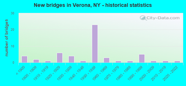
- New bridges - historical statistics
- 4Before 1900
- 21900-1909
- 11910-1919
- 61920-1929
- 41930-1939
- 11940-1949
- 231950-1959
- 31960-1969
- 11970-1979
- 11980-1989
- 51990-1999
- 12000-2009
- 12010-2019
- 12020-2022

- Reconstructed bridges - Historical Statistics
- 41920-1929
- 01930-1939
- 01940-1949
- 01950-1959
- 11960-1969
- 01970-1979
- 21980-1989
- 21990-1999
- 02000-2009
- 72010-2019


- Bridge Condition - Deck
- 8.6%Excellent
- 11.4%Very good
- 8.6%Good
- 20.0%Satisfactory
- 37.1%Fair
- 11.4%Poor
- 2.9%Serious

- Bridge Condition - Superstructure
- 11.1%Excellent
- 13.9%Very good
- 11.1%Good
- 16.7%Satisfactory
- 27.8%Fair
- 19.4%Poor

- Bridge Condition - Substructure
- 8.3%Excellent
- 11.1%Very good
- 13.9%Good
- 22.2%Satisfactory
- 27.8%Fair
- 16.7%Poor

- Bridge Condition - Channel
- 5.1%Excellent
- 10.3%Very good
- 23.1%Good
- 30.8%Satisfactory
- 23.1%Fair
- 7.7%Poor

- Bridge Condition - Culverts
- 27.3%Good
- 36.4%Satisfactory
- 18.2%Fair
- 18.2%Serious
Find on map >> Show street view
Structure Number: 102199, Location: 0.2 MI E JCT RTS 31 & 316 (Lat: 43.154378, Lng: -75.718094), Route carried "on" structure: State highway 31, Year Built: 2013, Status: Open, Structure Length: 4.91m (16.11ft), Average Daily Traffic: 4,264 (year 2018), Truck Traffic: 8%, Average Future Daily Traffic: 4,290 (year 2040), Design Load: HL 93, Features Intersected: ONEIDA CREEK
Minimum Vertical Clearance: 30+ m (98+ ft), Kilometerpoint: 0.145, Lanes on structure: 2, Base Highway Network: Yes, Owner: State Highway Agency, Approaching Roadway Width: 12.2m (40.0ft), Skew: 1 degrees, Material/Design: Steel, Design/Construction: Stringer/Multi-beam, Number Of Spans In Main Unit: 1, Length of Maximum Span: 48.5m (159.1ft), Curb-To-Curb Width: 12.2m (40.0ft), Out-to-Out Width: 13.2m (43.3ft)
Condition: Deck: Good, Superstructure: Very good, Substructure: Excellent, Channel: Very good, Inventory Rating: 74.4 metric tons, Method Used To Determine Inventory Rating: Load Factor (LF), Structural Evaluation: Equal to present desirable criteria, Deck Geometry: Equal to present minimum criteria, Waterway Adequacy: Equal to present minimum criteria, Approach Roadway Alignment: Equal to present desirable criteria, Length Of Structure Improvement: 4.90m (16.08ft), Designated Inspection Frequency: Every 24 months, Underwater Inspection Frequency: Every 60 months, Inspection Date: November 2021, Underwater Inspection Date: June 2012, Bridge Improvement Cost: $1,120,000, Roadway Improvement Cost: $656,000, Total Project Cost: $1,776,000 ( Estimate for 2021), Deck Structure Type: Concrete Cast-file-Place, Wearing Surface/Protective System: Wearing Surface: Monolithic Concrete, Deck Protection: Epoxy Coated Reinforcing
Find on map >> Show street view
Structure Number: 1022, Location: 01MI EJCT RTS 31+46 (Lat: 43.148347, Lng: -75.674819), Route carried "on" structure: State highway 31, Year Built: 1960, Status: Posted for load-capacity, Structure Length: 0.85m (2.79ft), Average Daily Traffic: 4,119 (year 2020), Truck Traffic: 9%, Average Future Daily Traffic: 4,144 (year 2040), Design Load: HS 20, Features Intersected: OLD ERIE CANAL
Minimum Vertical Clearance: 30+ m (98+ ft), Kilometerpoint: 3.765, Lanes on structure: 2, Base Highway Network: Yes, Owner: State Highway Agency, Approaching Roadway Width: 10.7m (35.1ft), Material/Design: Steel, Design/Construction: Culvert, Number Of Spans In Main Unit: 2, Length of Maximum Span: 3.6m (11.8ft)
Condition: Channel: Satisfactory, Culverts: Serious, Operating Rating: 73.6 metric tons, Method Used To Determine Operating Rating: Field evaluation and documented engineering judgment, Inventory Rating: 13.1 metric tons, Method Used To Determine Inventory Rating: Field evaluation and documented engineering judgment, Structural Evaluation: High priority of corrective action, Waterway Adequacy: Somewhat better than minimum adequacy, Approach Roadway Alignment: Equal to present desirable criteria, Length Of Structure Improvement: 0.85m (2.79ft), Designated Inspection Frequency: Every 12 months, Underwater Inspection Frequency: Every 60 months, Inspection Date: May 2021, Underwater Inspection Date: October 2017, Bridge Improvement Cost: $177,000, Roadway Improvement Cost: $104,000, Total Project Cost: $281,000 ( Estimate for 2021), Wearing Surface/Protective System: Wearing Surface: Bituminous
Find on map >> Show street view
Structure Number: 102201, Location: 27MI E JCT RTS 31+46 (Lat: 43.139075, Lng: -75.624325), Route carried "on" structure: State highway 31, Year Built: 1932, Year Reconstructed: 1971, Status: Open, Structure Length: 0.88m (2.89ft), Average Daily Traffic: 4,119 (year 2020), Truck Traffic: 9%, Average Future Daily Traffic: 4,144 (year 2040), Design Load: H 20, Features Intersected: BRANDY BROOK
Minimum Vertical Clearance: 30+ m (98+ ft), Kilometerpoint: 8.013, Lanes on structure: 2, Base Highway Network: Yes, Owner: State Highway Agency, Approaching Roadway Width: 12.8m (42.0ft), Material/Design: Concrete, Design/Construction: Culvert, Number Of Spans In Main Unit: 2, Length of Maximum Span: 4.2m (13.8ft), Curb-To-Curb Width: 14.2m (46.6ft), Out-to-Out Width: 14.8m (48.6ft)
Condition: Channel: Satisfactory, Culverts: Fair, Operating Rating: 72.7 metric tons, Method Used To Determine Operating Rating: Field evaluation and documented engineering judgment, Inventory Rating: 29.4 metric tons, Method Used To Determine Inventory Rating: Field evaluation and documented engineering judgment, Structural Evaluation: Somewhat better than minimum adequacy, Deck Geometry: Superior to present desirable criteria, Waterway Adequacy: Somewhat better than minimum adequacy, Approach Roadway Alignment: Equal to present desirable criteria, Length Of Structure Improvement: 0.88m (2.89ft), Designated Inspection Frequency: Every 24 months, Underwater Inspection Frequency: Every 60 months, Inspection Date: November 2021, Underwater Inspection Date: August 2017, Bridge Improvement Cost: $397,000, Roadway Improvement Cost: $232,000, Total Project Cost: $629,000 ( Estimate for 2021), Wearing Surface/Protective System: Wearing Surface: Bituminous
Find on map >> Show street view
Structure Number: 102202, Location: 07MI W JCT RTS 365+31 (Lat: 43.134386, Lng: -75.590822), Route carried "on" structure: State highway 31, Year Built: 1932, Status: Open, Structure Length: 0.88m (2.89ft), Average Daily Traffic: 4,119 (year 2020), Truck Traffic: 9%, Average Future Daily Traffic: 4,144 (year 2040), Design Load: H 15, Features Intersected: STONY CREEK
Minimum Vertical Clearance: 30+ m (98+ ft), Kilometerpoint: 10.845, Lanes on structure: 2, Base Highway Network: Yes, Owner: State Highway Agency, Approaching Roadway Width: 12.8m (42.0ft), Material/Design: Concrete, Design/Construction: Culvert, Number Of Spans In Main Unit: 2, Length of Maximum Span: 4.0m (13.1ft), Curb-To-Curb Width: 14.3m (46.9ft), Out-to-Out Width: 14.9m (48.9ft)
Condition: Channel: Good, Culverts: Satisfactory, Operating Rating: 50.0 metric tons, Method Used To Determine Operating Rating: Field evaluation and documented engineering judgment, Inventory Rating: 22.0 metric tons, Method Used To Determine Inventory Rating: Field evaluation and documented engineering judgment, Structural Evaluation: Somewhat better than minimum adequacy, Deck Geometry: Superior to present desirable criteria, Waterway Adequacy: Somewhat better than minimum adequacy, Approach Roadway Alignment: Equal to present desirable criteria, Length Of Structure Improvement: 0.88m (2.89ft), Designated Inspection Frequency: Every 24 months, Underwater Inspection Frequency: Every 60 months, Inspection Date: May 2020, Underwater Inspection Date: June 2020, Bridge Improvement Cost: $257,000, Roadway Improvement Cost: $150,000, Total Project Cost: $407,000 ( Estimate for 2021)
Find on map >> Show street view
Structure Number: 102203, Location: 06MI W JCT RTS 365+31 (Lat: 43.134044, Lng: -75.588642), Route carried "on" structure: State highway 31, Year Built: 1937, Year Reconstructed: 1990, Status: Open, Structure Length: 0.79m (2.59ft), Average Daily Traffic: 4,119 (year 2020), Truck Traffic: 9%, Average Future Daily Traffic: 4,144 (year 2040), Design Load: H 20, Features Intersected: STONY CREEK
Minimum Vertical Clearance: 30+ m (98+ ft), Kilometerpoint: 11.022, Lanes on structure: 2, Base Highway Network: Yes, Owner: State Highway Agency, Approaching Roadway Width: 12.2m (40.0ft), Skew: 4 degrees, Material/Design: Steel, Design/Construction: Culvert, Number Of Spans In Main Unit: 2, Length of Maximum Span: 3.9m (12.8ft)
Condition: Channel: Satisfactory, Culverts: Fair, Operating Rating: 71.7 metric tons, Method Used To Determine Operating Rating: Field evaluation and documented engineering judgment, Inventory Rating: 19.6 metric tons, Method Used To Determine Inventory Rating: Field evaluation and documented engineering judgment, Structural Evaluation: Somewhat better than minimum adequacy, Waterway Adequacy: High priority of corrective action, Approach Roadway Alignment: Equal to present desirable criteria, Length Of Structure Improvement: 0.79m (2.59ft), Designated Inspection Frequency: Every 24 months, Inspection Date: June 2020, Bridge Improvement Cost: $188,000, Roadway Improvement Cost: $110,000, Total Project Cost: $298,000 ( Estimate for 2021), Wearing Surface/Protective System: Wearing Surface: Bituminous
Find on map >> Show street view
Structure Number: 102204, Location: 0.5 MI W JCT RTS 365 & 31 (Lat: 43.133797, Lng: -75.586772), Route carried "on" structure: State highway 31, Year Built: 1990, Status: Open, Structure Length: 4.79m (15.72ft), Average Daily Traffic: 4,119 (year 2020), Truck Traffic: 9%, Average Future Daily Traffic: 5,003 (year 2040), Design Load: HS 20, Features Intersected: CSX TRANS/AMTRAK
Minimum Vertical Clearance: 30+ m (98+ ft), Kilometerpoint: 11.166, Lanes on structure: 2, Base Highway Network: Yes, Owner: State Highway Agency, Approaching Roadway Width: 12.2m (40.0ft), Skew: 2 degrees, Material/Design: Steel continuous, Design/Construction: Stringer/Multi-beam, Number Of Spans In Main Unit: 3, Length of Maximum Span: 21.6m (70.9ft), Curb-To-Curb Width: 12.0m (39.4ft), Out-to-Out Width: 13.0m (42.7ft)
Condition: Deck: Satisfactory, Superstructure: Excellent, Substructure: Good, Operating Rating: 62.6 metric tons, Method Used To Determine Operating Rating: Load Factor (LF), Inventory Rating: 32.7 metric tons, Method Used To Determine Inventory Rating: Load Factor (LF), Structural Evaluation: Better than present minimum criteria, Deck Geometry: Somewhat better than minimum adequacy, Underclear: Better than present minimum criteria, Approach Roadway Alignment: Equal to present desirable criteria, Length Of Structure Improvement: 4.78m (15.68ft), Designated Inspection Frequency: Every 24 months, Inspection Date: August 2020, Bridge Improvement Cost: $1,088,000, Roadway Improvement Cost: $637,000, Total Project Cost: $1,726,000 ( Estimate for 2021), Deck Structure Type: Concrete Cast-file-Place, Wearing Surface/Protective System: Wearing Surface: Integral Concrete, Deck Protection: Epoxy Coated Reinforcing
Find on map >> Show street view
Structure Number: 10257, Location: 1.7 MI E JCT RTS 46 & 49 (Lat: 43.218578, Lng: -75.558250), Route carried "on" structure: State highway 46, Year Built: 1991, Status: Open, Structure Length: 1.89m (6.20ft), Average Daily Traffic: 4,947 (year 2016), Truck Traffic: 8%, Average Future Daily Traffic: 4,977 (year 2040), Design Load: HS 20, Features Intersected: STONEY CREEK
Minimum Vertical Clearance: 30+ m (98+ ft), Kilometerpoint: 16.991, Lanes on structure: 2, Base Highway Network: Yes, Owner: State Highway Agency, Approaching Roadway Width: 11.0m (36.1ft), Material/Design: Prestressed concrete, Design/Construction: Box Beam or Girders - Multiple, Number Of Spans In Main Unit: 1, Length of Maximum Span: 17.9m (58.7ft), Curb-To-Curb Width: 11.0m (36.1ft), Out-to-Out Width: 11.6m (38.1ft)
Condition: Deck: Fair, Superstructure: Very good, Substructure: Very good, Channel: Satisfactory, Operating Rating: 80.7 metric tons, Method Used To Determine Operating Rating: Load Factor (LF), Inventory Rating: 39.9 metric tons, Method Used To Determine Inventory Rating: Load Factor (LF), Structural Evaluation: Equal to present desirable criteria, Deck Geometry: Somewhat better than minimum adequacy, Waterway Adequacy: Equal to present desirable criteria, Approach Roadway Alignment: Equal to present desirable criteria, Length Of Structure Improvement: 1.88m (6.17ft), Designated Inspection Frequency: Every 24 months, Inspection Date: June 2021, Bridge Improvement Cost: $392,000, Roadway Improvement Cost: $229,000, Total Project Cost: $621,000 ( Estimate for 2021), Wearing Surface/Protective System: Wearing Surface: Bituminous
Find on map >> Show street view
Structure Number: 104226, Location: 04MI S JCT RTS 234+365 (Lat: 43.124681, Lng: -75.573964), Route carried "on" structure: State highway 31, Year Built: 1954, Year Reconstructed: 1993, Status: Open, Structure Length: 6.55m (21.49ft), Average Daily Traffic: 4,327 (year 2020), Truck Traffic: 6%, Average Future Daily Traffic: 4,513 (year 2040), Design Load: HS 20+Mod, Features Intersected: 90IX EB, RTE I90
Minimum Vertical Clearance: 30+ m (98+ ft), Kilometerpoint: 12.663, Lanes on structure: 2, Lanes under structure: 4, Base Highway Network: Yes, Owner: State Toll Authority, Approaching Roadway Width: 11.6m (38.1ft), Skew: 2 degrees, Material/Design: Steel continuous, Design/Construction: Stringer/Multi-beam, Number Of Spans In Main Unit: 4, Length of Maximum Span: 19.2m (63.0ft), Curb-To-Curb Width: 11.0m (36.1ft), Out-to-Out Width: 11.9m (39.0ft)
Condition: Deck: Fair, Superstructure: Fair, Substructure: Fair, Operating Rating: 75.3 metric tons, Method Used To Determine Operating Rating: Load Factor (LF), Inventory Rating: 40.8 metric tons, Method Used To Determine Inventory Rating: Load Factor (LF), Structural Evaluation: Somewhat better than minimum adequacy, Deck Geometry: Somewhat better than minimum adequacy, Underclear: High priority of corrective action, Approach Roadway Alignment: Equal to present desirable criteria, Length Of Structure Improvement: 6.55m (21.49ft), Designated Inspection Frequency: Every 24 months, Inspection Date: August 2021, Bridge Improvement Cost: $1,277,000, Roadway Improvement Cost: $748,000, Total Project Cost: $2,025,000 ( Estimate for 2021), Deck Structure Type: Concrete Cast-file-Place, Wearing Surface/Protective System: Wearing Surface: Integral Concrete, Deck Protection: Epoxy Coated Reinforcing
Find on map >> Show street view
Structure Number: 1046709, Location: .3 MI S JCT SH234 & SH365 (Lat: 43.124125, Lng: -75.589325), Route carried "on" structure: State highway 365, Year Built: 1954, Year Reconstructed: 2017, Status: Open, Structure Length: 6.95m (22.80ft), Average Daily Traffic: 15,996 (year 2016), Truck Traffic: 10%, Average Future Daily Traffic: 16,071 (year 2040), Design Load: HS 20, Features Intersected: 90IX EB, RTE I90
Minimum Vertical Clearance: 30+ m (98+ ft), Kilometerpoint: 6.500, Lanes on structure: 5, Lanes under structure: 4, Base Highway Network: Yes, Owner: State Toll Authority, Approaching Roadway Width: 26.2m (86.0ft), Skew: 32 degrees, Material/Design: Steel continuous, Design/Construction: Stringer/Multi-beam, Number Of Spans In Main Unit: 4, Length of Maximum Span: 20.4m (66.9ft), Curb-To-Curb Width: 28.7m (94.2ft), Out-to-Out Width: 30.8m (101.0ft)
Condition: Deck: Fair, Superstructure: Satisfactory, Substructure: Satisfactory, Operating Rating: 53.5 metric tons, Method Used To Determine Operating Rating: Load Factor (LF), Inventory Rating: 32.7 metric tons, Method Used To Determine Inventory Rating: Load Factor (LF), Structural Evaluation: Equal to present minimum criteria, Deck Geometry: Superior to present desirable criteria, Underclear: High priority of corrective action, Approach Roadway Alignment: Equal to present desirable criteria, Length Of Structure Improvement: 6.94m (22.77ft), Designated Inspection Frequency: Every 24 months, Inspection Date: September 2021, Bridge Improvement Cost: $3,604,000, Roadway Improvement Cost: $2,110,000, Total Project Cost: $5,714,000 ( Estimate for 2021), Deck Structure Type: Concrete Cast-file-Place, Wearing Surface/Protective System: Wearing Surface: Integral Concrete, Deck Protection: Epoxy Coated Reinforcing
Find on map >> Show street view
Structure Number: 220611, Location: 2 MI SE STATE BRIDGE (Lat: 43.129514, Lng: -75.645442), Route carried "on" structure: Other road , Year Built: 1940, Status: Open, Structure Length: 1.01m (3.31ft), Average Daily Traffic: 222 (year 2016), Truck Traffic: 25%, Average Future Daily Traffic: 311 (year 2036), Design Load: H 15, Features Intersected: BRANDY BROOK, Facility Carried by Structure: FOSTER CORNERS RD
Minimum Vertical Clearance: 30+ m (98+ ft), Kilometerpoint: 2.253, Lanes on structure: 2, Owner: Town or Township Highway Agency, Approaching Roadway Width: 5.2m (17.1ft), Material/Design: Steel, Design/Construction: Stringer/Multi-beam, Number Of Spans In Main Unit: 1, Length of Maximum Span: 9.7m (31.8ft), Curb-To-Curb Width: 6.0m (19.7ft), Out-to-Out Width: 6.2m (20.3ft)
Condition: Deck: Poor, Superstructure: Fair, Substructure: Poor, Channel: Poor, Operating Rating: 53.5 metric tons, Method Used To Determine Operating Rating: Load Factor (LF), Inventory Rating: 23.6 metric tons, Method Used To Determine Inventory Rating: Load Factor (LF), Structural Evaluation: Meets minimum limits, Deck Geometry: High priority of corrective action, Waterway Adequacy: Meets minimum limits, Approach Roadway Alignment: Equal to present desirable criteria, Length Of Structure Improvement: 1.00m (3.28ft), Designated Inspection Frequency: Every 24 months, Inspection Date: August 2020, Bridge Improvement Cost: $159,000, Roadway Improvement Cost: $93,000, Total Project Cost: $253,000 ( Estimate for 2021), Deck Structure Type: Concrete Cast-file-Place, Wearing Surface/Protective System: Wearing Surface: Bituminous
Find on map >> Show street view
Structure Number: 220613, Location: 4 MI N OF VERONA (Lat: 43.188431, Lng: -75.562789), Route carried "on" structure: Other road , Year Built: 1900, Year Reconstructed: 1996, Status: Open, Structure Length: 0.82m (2.69ft), Average Daily Traffic: 106 (year 2016), Truck Traffic: 4%, Average Future Daily Traffic: 148 (year 2036), Features Intersected: STONY CREEK, Facility Carried by Structure: WEHLING ROAD
Minimum Vertical Clearance: 30+ m (98+ ft), Kilometerpoint: 0.097, Lanes on structure: 1, Owner: Town or Township Highway Agency, Approaching Roadway Width: 4.9m (16.1ft), Material/Design: Prestressed concrete, Design/Construction: Box Beam or Girders - Multiple, Number Of Spans In Main Unit: 1, Length of Maximum Span: 7.0m (23.0ft), Curb-To-Curb Width: 6.1m (20.0ft), Out-to-Out Width: 6.2m (20.3ft)
Condition: Deck: Satisfactory, Superstructure: Satisfactory, Substructure: Fair, Channel: Fair, Operating Rating: 47.0 metric tons, Method Used To Determine Operating Rating: Load and Resistance Factor Rating (LRFR) rating reported by rating factor(RF) method using HL-93 loadings, Inventory Rating: 36.3 metric tons, Method Used To Determine Inventory Rating: Load and Resistance Factor Rating (LRFR) rating reported by rating factor(RF) method using HL-93 loadings, Structural Evaluation: Somewhat better than minimum adequacy, Deck Geometry: Meets minimum limits, Waterway Adequacy: Meets minimum limits, Approach Roadway Alignment: Equal to present minimum criteria, Length Of Structure Improvement: 0.82m (2.69ft), Designated Inspection Frequency: Every 24 months, Inspection Date: September 2020, Bridge Improvement Cost: $178,000, Roadway Improvement Cost: $104,000, Total Project Cost: $283,000 ( Estimate for 2021), Wearing Surface/Protective System: Wearing Surface: Bituminous
Find on map >> Show street view
Structure Number: 220614, Location: 1 MI.W.JCT.90 & 26 (Lat: 43.147244, Lng: -75.528314), Route carried "on" structure: Other road , Year Built: 1972, Status: Open, Structure Length: 0.76m (2.49ft), Average Daily Traffic: 82 (year 2017), Truck Traffic: 1%, Average Future Daily Traffic: 115 (year 2037), Features Intersected: MUD CREEK, Facility Carried by Structure: CR50 REBER ROAD
Minimum Vertical Clearance: 30+ m (98+ ft), Kilometerpoint: 1.239, Lanes on structure: 2, Owner: Town or Township Highway Agency, Approaching Roadway Width: 5.8m (19.0ft), Skew: 1 degrees, Material/Design: Steel, Design/Construction: Culvert, Number Of Spans In Main Unit: 2, Length of Maximum Span: 3.4m (11.2ft)
Condition: Channel: Satisfactory, Culverts: Satisfactory, Operating Rating: 74.9 metric tons, Method Used To Determine Operating Rating: Field evaluation and documented engineering judgment, Inventory Rating: 32.7 metric tons, Method Used To Determine Inventory Rating: Field evaluation and documented engineering judgment, Structural Evaluation: Equal to present minimum criteria, Waterway Adequacy: Meets minimum limits, Approach Roadway Alignment: Better than present minimum criteria, Length Of Structure Improvement: 0.76m (2.49ft), Designated Inspection Frequency: Every 24 months, Inspection Date: May 2020, Bridge Improvement Cost: $86,000, Roadway Improvement Cost: $50,000, Total Project Cost: $136,000 ( Estimate for 2021), Wearing Surface/Protective System: Wearing Surface: Bituminous
Find on map >> Show street view
Structure Number: 220616, Location: AT VERONA (Lat: 43.140194, Lng: -75.525639), Route carried "on" structure: Other road , Year Built: 1995, Status: Open, Structure Length: 0.79m (2.59ft), Average Daily Traffic: 82 (year 2017), Truck Traffic: 1%, Average Future Daily Traffic: 115 (year 2037), Design Load: HS 20, Features Intersected: BRANCH MUD CREEK, Facility Carried by Structure: REBER ROAD
Minimum Vertical Clearance: 30+ m (98+ ft), Kilometerpoint: 0.370, Lanes on structure: 2, Owner: Town or Township Highway Agency, Approaching Roadway Width: 5.8m (19.0ft), Material/Design: Prestressed concrete, Design/Construction: Box Beam or Girders - Multiple, Number Of Spans In Main Unit: 1, Length of Maximum Span: 7.0m (23.0ft), Curb-To-Curb Width: 5.6m (18.4ft), Out-to-Out Width: 5.8m (19.0ft)
Condition: Deck: Good, Superstructure: Satisfactory, Substructure: Satisfactory, Channel: Satisfactory, Operating Rating: 68.0 metric tons, Method Used To Determine Operating Rating: Load Factor (LF), Inventory Rating: 50.8 metric tons, Method Used To Determine Inventory Rating: Load Factor (LF), Structural Evaluation: Equal to present minimum criteria, Deck Geometry: Meets minimum limits, Waterway Adequacy: Meets minimum limits, Approach Roadway Alignment: Equal to present minimum criteria, Length Of Structure Improvement: 0.79m (2.59ft), Designated Inspection Frequency: Every 24 months, Inspection Date: October 2021, Bridge Improvement Cost: $163,000, Roadway Improvement Cost: $96,000, Total Project Cost: $259,000 ( Estimate for 2021), Wearing Surface/Protective System: Wearing Surface: Bituminous
Find on map >> Show street view
Structure Number: 220617, Location: 1.5 MI SE STATE BRIDGE (Lat: 43.127703, Lng: -75.660181), Route carried "on" structure: Other road , Year Built: 1961, Status: Open, Structure Length: 1.01m (3.31ft), Average Daily Traffic: 461 (year 2016), Truck Traffic: 4%, Average Future Daily Traffic: 645 (year 2036), Design Load: HS 20, Features Intersected: BRANDY BROOK, Facility Carried by Structure: FOSTER STREET
Minimum Vertical Clearance: 30+ m (98+ ft), Kilometerpoint: 1.223, Lanes on structure: 2, Owner: Town or Township Highway Agency, Approaching Roadway Width: 5.8m (19.0ft), Skew: 3 degrees, Material/Design: Steel, Design/Construction: Culvert, Number Of Spans In Main Unit: 2, Length of Maximum Span: 4.5m (14.8ft)
Condition: Channel: Poor, Culverts: Satisfactory, Operating Rating: 74.5 metric tons, Method Used To Determine Operating Rating: Field evaluation and documented engineering judgment, Inventory Rating: 19.6 metric tons, Method Used To Determine Inventory Rating: Field evaluation and documented engineering judgment, Structural Evaluation: Somewhat better than minimum adequacy, Waterway Adequacy: Meets minimum limits, Approach Roadway Alignment: Equal to present desirable criteria, Length Of Structure Improvement: 1.00m (3.28ft), Designated Inspection Frequency: Every 24 months, Inspection Date: August 2020, Bridge Improvement Cost: $113,000, Roadway Improvement Cost: $66,000, Total Project Cost: $180,000 ( Estimate for 2021), Wearing Surface/Protective System: Wearing Surface: Bituminous
Find on map >> Show street view
Structure Number: 220618, Location: .2 MI NW OF DURHAMVILLE (Lat: 43.131428, Lng: -75.681553), Route carried "on" structure: Other road , Year Built: 1906, Year Reconstructed: 2018, Status: Open, Structure Length: 0.98m (3.22ft), Average Daily Traffic: 267 (year 2016), Truck Traffic: 6%, Average Future Daily Traffic: 374 (year 2036), Design Load: HL 93, Features Intersected: BRANDY BROOK, Facility Carried by Structure: MAIN STREET
Minimum Vertical Clearance: 30+ m (98+ ft), Kilometerpoint: 0.869, Lanes on structure: 1, Owner: Town or Township Highway Agency, Approaching Roadway Width: 5.2m (17.1ft), Material/Design: Prestressed concrete, Design/Construction: Box Beam or Girders - Multiple, Number Of Spans In Main Unit: 1, Length of Maximum Span: 9.1m (29.9ft), Curb-To-Curb Width: 5.1m (16.7ft), Out-to-Out Width: 5.9m (19.4ft)
Condition: Deck: Very good, Superstructure: Very good, Substructure: Fair, Channel: Fair, Operating Rating: 51.8 metric tons, Method Used To Determine Operating Rating: Load and Resistance Factor Rating (LRFR) rating reported by rating factor(RF) method using HL-93 loadings, Inventory Rating: 39.9 metric tons, Method Used To Determine Inventory Rating: Load and Resistance Factor Rating (LRFR) rating reported by rating factor(RF) method using HL-93 loadings, Structural Evaluation: Somewhat better than minimum adequacy, Deck Geometry: High priority of replacement, Waterway Adequacy: Meets minimum limits, Approach Roadway Alignment: Better than present minimum criteria, Length Of Structure Improvement: 0.97m (3.18ft), Designated Inspection Frequency: Every 24 months, Inspection Date: June 2021, Bridge Improvement Cost: $229,000, Roadway Improvement Cost: $134,000, Total Project Cost: $363,000 ( Estimate for 2021), Wearing Surface/Protective System: Wearing Surface: Bituminous, Membrane: Preformed Fabric
Find on map >> Show street view
Structure Number: 226656, Location: .25 MI S OF I90 IN VERONA (Lat: 43.108742, Lng: -75.650317), Route carried "on" structure: County highway , Year Built: 1962, Status: Open, Structure Length: 5.43m (17.81ft), Average Daily Traffic: 729 (year 2020), Truck Traffic: 4%, Average Future Daily Traffic: 1,021 (year 2040), Design Load: HS 20, Features Intersected: CSX TRANS/ AMTRAK, Facility Carried by Structure: CR 48
Minimum Vertical Clearance: 30+ m (98+ ft), Kilometerpoint: 2.092, Lanes on structure: 2, Owner: County Highway Agency, Approaching Roadway Width: 7.3m (24.0ft), Skew: 2 degrees, Material/Design: Steel, Design/Construction: Stringer/Multi-beam, Number Of Spans In Main Unit: 3, Length of Maximum Span: 21.0m (68.9ft), Curb or Sidewalk Widths: Left: 0.8m (2.6ft), Right: 0.8m (2.6ft), Curb-To-Curb Width: 9.1m (29.9ft), Out-to-Out Width: 10.8m (35.4ft)
Condition: Deck: Satisfactory, Superstructure: Fair, Substructure: Good, Inventory Rating: 72.6 metric tons, Method Used To Determine Inventory Rating: Load Factor (LF), Structural Evaluation: Somewhat better than minimum adequacy, Deck Geometry: Equal to present minimum criteria, Underclear: Somewhat better than minimum adequacy, Approach Roadway Alignment: Equal to present desirable criteria, Length Of Structure Improvement: 5.42m (17.78ft), Designated Inspection Frequency: Every 24 months, Inspection Date: November 2020, Bridge Improvement Cost: $985,000, Roadway Improvement Cost: $577,000, Total Project Cost: $1,562,000 ( Estimate for 2021), Deck Structure Type: Concrete Cast-file-Place, Wearing Surface/Protective System: Wearing Surface: Monolithic Concrete
Find on map >> Show street view
Structure Number: 226839, Location: 2 MI SW STATE BRIDGE (Lat: 43.139789, Lng: -75.706644), Route carried "on" structure: Other road , Year Built: 1992, Status: Open, Structure Length: 0.64m (2.10ft), Average Daily Traffic: 81 (year 2018), Truck Traffic: 4%, Average Future Daily Traffic: 113 (year 2038), Design Load: H 20, Features Intersected: ONEIDA CREEK OVERFLOW, Facility Carried by Structure: SWALLOW ROAD
Minimum Vertical Clearance: 30+ m (98+ ft), Kilometerpoint: 0.048, Lanes on structure: 2, Owner: Town or Township Highway Agency, Approaching Roadway Width: 6.1m (20.0ft), Material/Design: Steel, Design/Construction: Culvert, Number Of Spans In Main Unit: 2, Length of Maximum Span: 2.7m (8.9ft)
Condition: Channel: Good, Culverts: Good, Operating Rating: 71.9 metric tons, Method Used To Determine Operating Rating: Field evaluation and documented engineering judgment, Inventory Rating: 32.7 metric tons, Method Used To Determine Inventory Rating: Field evaluation and documented engineering judgment, Structural Evaluation: Better than present minimum criteria, Waterway Adequacy: Somewhat better than minimum adequacy, Approach Roadway Alignment: Equal to present desirable criteria, Length Of Structure Improvement: 0.64m (2.10ft), Designated Inspection Frequency: Every 24 months, Inspection Date: June 2020, Bridge Improvement Cost: $76,000, Roadway Improvement Cost: $44,000, Total Project Cost: $120,000 ( Estimate for 2021), Wearing Surface/Protective System: Wearing Surface: Bituminous
Find on map >> Show street view
Structure Number: 331098, Location: .5 MI E VERONA BEACH ST P (Lat: 43.171408, Lng: -75.705436), Route carried "on" structure: County highway , Year Built: 1958, Status: Open, Structure Length: 0.94m (3.08ft), Average Daily Traffic: 1,014 (year 2017), Truck Traffic: 5%, Average Future Daily Traffic: 1,420 (year 2037), Design Load: H 20, Features Intersected: BLACK CREEK, Facility Carried by Structure: POPPLETON ROAD
Minimum Vertical Clearance: 30+ m (98+ ft), Kilometerpoint: 1.754, Lanes on structure: 2, Owner: County Highway Agency, Approaching Roadway Width: 7.0m (23.0ft), Material/Design: Steel, Design/Construction: Culvert, Number Of Spans In Main Unit: 2, Length of Maximum Span: 3.9m (12.8ft)
Condition: Channel: Poor, Culverts: Satisfactory, Operating Rating: 71.7 metric tons, Method Used To Determine Operating Rating: Field evaluation and documented engineering judgment, Inventory Rating: 19.6 metric tons, Method Used To Determine Inventory Rating: Field evaluation and documented engineering judgment, Structural Evaluation: Somewhat better than minimum adequacy, Waterway Adequacy: Meets minimum limits, Approach Roadway Alignment: Equal to present desirable criteria, Length Of Structure Improvement: 0.94m (3.08ft), Designated Inspection Frequency: Every 24 months, Inspection Date: September 2020, Bridge Improvement Cost: $129,000, Roadway Improvement Cost: $76,000, Total Project Cost: $205,000 ( Estimate for 2021)
Find on map >> Show street view
Structure Number: 331099, Location: 3 MI NW STATE BRIDGE (Lat: 43.174975, Lng: -75.722242), Route carried "on" structure: County highway , Year Built: 2002, Status: Open, Structure Length: 0.67m (2.20ft), Average Daily Traffic: 1,014 (year 2017), Truck Traffic: 5%, Average Future Daily Traffic: 1,420 (year 2037), Design Load: H 20, Features Intersected: BLACK CREEK, Facility Carried by Structure: POPPLETON ROAD
Minimum Vertical Clearance: 30+ m (98+ ft), Kilometerpoint: 0.338, Lanes on structure: 2, Owner: County Highway Agency, Approaching Roadway Width: 11.0m (36.1ft), Material/Design: Concrete, Design/Construction: Frame, Number Of Spans In Main Unit: 1, Length of Maximum Span: 6.4m (21.0ft), Curb-To-Curb Width: 10.5m (34.4ft), Out-to-Out Width: 11.6m (38.1ft)
Condition: Deck: Very good, Superstructure: Very good, Substructure: Very good, Channel: Excellent, Operating Rating: 49.0 metric tons, Method Used To Determine Operating Rating: Load Factor (LF), Inventory Rating: 29.0 metric tons, Method Used To Determine Inventory Rating: Load Factor (LF), Structural Evaluation: Better than present minimum criteria, Deck Geometry: Equal to present minimum criteria, Waterway Adequacy: Equal to present minimum criteria, Approach Roadway Alignment: Equal to present desirable criteria, Length Of Structure Improvement: 0.67m (2.20ft), Designated Inspection Frequency: Every 24 months, Inspection Date: June 2020, Bridge Improvement Cost: $316,000, Roadway Improvement Cost: $185,000, Total Project Cost: $502,000 ( Estimate for 2021), Wearing Surface/Protective System: Wearing Surface: Bituminous
Find on map >> Show street view
Structure Number: 331121, Location: 4 MI SE JCT SH 49 & SH 46 (Lat: 43.196792, Lng: -75.556308), Route carried "on" structure: County highway , Year Built: 1931, Status: Posted for load, Structure Length: 0.85m (2.79ft), Average Daily Traffic: 233 (year 2016), Truck Traffic: 6%, Average Future Daily Traffic: 326 (year 2036), Features Intersected: STONY CREEK, Facility Carried by Structure: CR 50
Minimum Vertical Clearance: 30+ m (98+ ft), Kilometerpoint: 1.738, Lanes on structure: 2, Owner: County Highway Agency, Approaching Roadway Width: 6.1m (20.0ft), Material/Design: Steel, Design/Construction: Stringer/Multi-beam, Number Of Spans In Main Unit: 1, Length of Maximum Span: 7.9m (25.9ft), Curb-To-Curb Width: 7.1m (23.3ft), Out-to-Out Width: 8.0m (26.2ft)
Condition: Deck: Fair, Superstructure: Satisfactory, Substructure: Fair, Channel: Fair, Operating Rating: 28.1 metric tons, Method Used To Determine Operating Rating: Load Factor (LF), Inventory Rating: 16.3 metric tons, Method Used To Determine Inventory Rating: Load Factor (LF), Structural Evaluation: Somewhat better than minimum adequacy, Deck Geometry: Meets minimum limits, Waterway Adequacy: Meets minimum limits, Approach Roadway Alignment: Equal to present minimum criteria, Bridge Posting: Required (Relationship of Operating Rating to Maximum Legal Load: > 39.9% below), Length Of Structure Improvement: 0.85m (2.79ft), Designated Inspection Frequency: Every 12 months, Inspection Date: April 2021, Bridge Improvement Cost: $239,000, Roadway Improvement Cost: $140,000, Total Project Cost: $379,000 ( Estimate for 2021), Deck Structure Type: Concrete Cast-file-Place, Wearing Surface/Protective System: Wearing Surface: Bituminous
Find on map >> Show street view
Structure Number: 331122, Location: 2.5 MI SE OF NEW LONDON (Lat: 43.174214, Lng: -75.559667), Route carried "on" structure: County highway , Year Built: 1951, Year Reconstructed: 2015, Status: Open, Structure Length: 0.85m (2.79ft), Average Daily Traffic: 1,392 (year 2018), Truck Traffic: 8%, Average Future Daily Traffic: 1,949 (year 2038), Features Intersected: BRANCH OF STONY CREEK, Facility Carried by Structure: CR52 BLACKMAN CORN
Minimum Vertical Clearance: 30+ m (98+ ft), Kilometerpoint: 9.654, Lanes on structure: 2, Owner: County Highway Agency, Approaching Roadway Width: 7.9m (25.9ft), Material/Design: Prestressed concrete, Design/Construction: Box Beam or Girders - Multiple, Number Of Spans In Main Unit: 1, Length of Maximum Span: 7.9m (25.9ft), Curb-To-Curb Width: 8.0m (26.2ft), Out-to-Out Width: 9.0m (29.5ft)
Condition: Deck: Very good, Superstructure: Very good, Substructure: Very good, Channel: Satisfactory, Operating Rating: 67.4 metric tons, Method Used To Determine Operating Rating: Load and Resistance Factor Rating (LRFR) rating reported by rating factor(RF) method using HL-93 loadings, Inventory Rating: 51.8 metric tons, Method Used To Determine Inventory Rating: Load and Resistance Factor Rating (LRFR) rating reported by rating factor(RF) method using HL-93 loadings, Structural Evaluation: Equal to present desirable criteria, Deck Geometry: Meets minimum limits, Waterway Adequacy: Somewhat better than minimum adequacy, Approach Roadway Alignment: Equal to present minimum criteria, Length Of Structure Improvement: 0.85m (2.79ft), Designated Inspection Frequency: Every 24 months, Inspection Date: August 2020, Bridge Improvement Cost: $287,000, Roadway Improvement Cost: $168,000, Total Project Cost: $454,000 ( Estimate for 2021), Wearing Surface/Protective System: Wearing Surface: Bituminous
Find on map >> Show street view
Structure Number: 331123, Location: 2.0 MI SE OF NEW LONDON (Lat: 43.181611, Lng: -75.566886), Route carried "on" structure: County highway , Year Built: 1957, Status: Open, Structure Length: 1.19m (3.90ft), Average Daily Traffic: 1,392 (year 2018), Truck Traffic: 8%, Average Future Daily Traffic: 1,949 (year 2038), Design Load: H 20, Features Intersected: STONY CREEK, Facility Carried by Structure: CR52 BLACKMAN CORN
Minimum Vertical Clearance: 30+ m (98+ ft), Kilometerpoint: 8.624, Lanes on structure: 2, Owner: County Highway Agency, Approaching Roadway Width: 6.1m (20.0ft), Skew: 2 degrees, Material/Design: Steel, Design/Construction: Stringer/Multi-beam, Number Of Spans In Main Unit: 1, Length of Maximum Span: 11.5m (37.7ft), Curb-To-Curb Width: 7.5m (24.6ft), Out-to-Out Width: 7.7m (25.3ft)
Condition: Deck: Satisfactory, Superstructure: Fair, Substructure: Fair, Channel: Satisfactory, Operating Rating: 26.2 metric tons, Method Used To Determine Operating Rating: Load and Resistance Factor Rating (LRFR) rating reported by rating factor(RF) method using HL-93 loadings, Inventory Rating: 20.1 metric tons, Method Used To Determine Inventory Rating: Load and Resistance Factor Rating (LRFR) rating reported by rating factor(RF) method using HL-93 loadings, Structural Evaluation: Somewhat better than minimum adequacy, Deck Geometry: Meets minimum limits, Waterway Adequacy: Somewhat better than minimum adequacy, Approach Roadway Alignment: Equal to present minimum criteria, Length Of Structure Improvement: 1.18m (3.87ft), Designated Inspection Frequency: Every 24 months, Inspection Date: August 2020, Bridge Improvement Cost: $319,000, Roadway Improvement Cost: $187,000, Total Project Cost: $506,000 ( Estimate for 2021), Deck Structure Type: Concrete Cast-file-Place, Wearing Surface/Protective System: Wearing Surface: Bituminous
Find on map >> Show street view
Structure Number: 331124, Location: 3 MI SW JCT RTS 365 & 26 (Lat: 43.154836, Lng: -75.543550), Route carried "on" structure: County highway , Year Built: 1993, Status: Open, Structure Length: 0.98m (3.22ft), Average Daily Traffic: 1,125 (year 2017), Truck Traffic: 7%, Average Future Daily Traffic: 1,575 (year 2037), Features Intersected: MUD CREEK, Facility Carried by Structure: CR52 BLACKMAN CORN
Minimum Vertical Clearance: 30+ m (98+ ft), Kilometerpoint: 12.212, Lanes on structure: 2, Owner: County Highway Agency, Approaching Roadway Width: 7.3m (24.0ft), Material/Design: Steel, Design/Construction: Culvert, Number Of Spans In Main Unit: 2, Length of Maximum Span: 4.5m (14.8ft)
Condition: Channel: Fair, Culverts: Good, Operating Rating: 75.8 metric tons, Method Used To Determine Operating Rating: Field evaluation and documented engineering judgment, Inventory Rating: 32.7 metric tons, Method Used To Determine Inventory Rating: Field evaluation and documented engineering judgment, Structural Evaluation: Better than present minimum criteria, Waterway Adequacy: Meets minimum limits, Approach Roadway Alignment: Equal to present desirable criteria, Length Of Structure Improvement: 0.97m (3.18ft), Designated Inspection Frequency: Every 24 months, Inspection Date: August 2020, Bridge Improvement Cost: $139,000, Roadway Improvement Cost: $81,000, Total Project Cost: $220,000 ( Estimate for 2021), Wearing Surface/Protective System: Wearing Surface: Bituminous
Find on map >> Show street view
Structure Number: 331125, Location: 6 MI NW OF VERONA (Lat: 43.202278, Lng: -75.552497), Route carried "on" structure: County highway , Year Built: 1953, Status: Open, Structure Length: 1.34m (4.40ft), Average Daily Traffic: 409 (year 2009), Truck Traffic: 4%, Average Future Daily Traffic: 573 (year 2029), Design Load: H 20, Features Intersected: STONY CREEK, Facility Carried by Structure: CR60A STONEY CREEK
Minimum Vertical Clearance: 30+ m (98+ ft), Kilometerpoint: 0.756, Lanes on structure: 2, Owner: County Highway Agency, Approaching Roadway Width: 5.8m (19.0ft), Skew: 2 degrees, Material/Design: Steel, Design/Construction: Stringer/Multi-beam, Number Of Spans In Main Unit: 1, Length of Maximum Span: 12.8m (42.0ft), Curb-To-Curb Width: 7.7m (25.3ft), Out-to-Out Width: 7.8m (25.6ft)
Condition: Deck: Fair, Superstructure: Satisfactory, Substructure: Satisfactory, Channel: Fair, Operating Rating: 65.3 metric tons, Method Used To Determine Operating Rating: Load Factor (LF), Inventory Rating: 39.0 metric tons, Method Used To Determine Inventory Rating: Load Factor (LF), Structural Evaluation: Equal to present minimum criteria, Deck Geometry: Meets minimum limits, Waterway Adequacy: Meets minimum limits, Approach Roadway Alignment: Equal to present minimum criteria, Length Of Structure Improvement: 1.34m (4.40ft), Designated Inspection Frequency: Every 24 months, Inspection Date: October 2020, Bridge Improvement Cost: $355,000, Roadway Improvement Cost: $208,000, Total Project Cost: $562,000 ( Estimate for 2021), Deck Structure Type: Concrete Cast-file-Place, Wearing Surface/Protective System: Wearing Surface: Bituminous
Find on map >> Show street view
Structure Number: 331126, Location: VERONA (Lat: 43.160561, Lng: -75.543608), Route carried "on" structure: County highway , Year Built: 1981, Status: Open, Structure Length: 1.13m (3.71ft), Average Daily Traffic: 337 (year 2016), Truck Traffic: 8%, Average Future Daily Traffic: 472 (year 2036), Features Intersected: MUD CREEK, Facility Carried by Structure: CR83 ONEIDA ROAD
Minimum Vertical Clearance: 30+ m (98+ ft), Kilometerpoint: 2.253, Lanes on structure: 2, Owner: County Highway Agency, Approaching Roadway Width: 5.8m (19.0ft), Material/Design: Steel, Design/Construction: Culvert, Number Of Spans In Main Unit: 2, Length of Maximum Span: 4.8m (15.7ft)
Condition: Channel: Fair, Culverts: Good, Operating Rating: 76.0 metric tons, Method Used To Determine Operating Rating: Field evaluation and documented engineering judgment, Inventory Rating: 32.7 metric tons, Method Used To Determine Inventory Rating: Field evaluation and documented engineering judgment, Structural Evaluation: Better than present minimum criteria, Waterway Adequacy: Meets minimum limits, Approach Roadway Alignment: Better than present minimum criteria, Length Of Structure Improvement: 1.12m (3.67ft), Designated Inspection Frequency: Every 24 months, Inspection Date: April 2020, Bridge Improvement Cost: $127,000, Roadway Improvement Cost: $74,000, Total Project Cost: $202,000 ( Estimate for 2021)
Find on map >> Show street view
Structure Number: 331128, Location: VERONA (Lat: 43.151883, Lng: -75.581719), Route carried "on" structure: Other road , Year Built: 1953, Year Reconstructed: 2019, Status: Open, Structure Length: 0.98m (3.22ft), Average Daily Traffic: 205 (year 2019), Truck Traffic: 4%, Average Future Daily Traffic: 287 (year 2039), Design Load: HL 93, Features Intersected: STONY CREEK, Facility Carried by Structure: DWYER ROAD
Minimum Vertical Clearance: 30+ m (98+ ft), Kilometerpoint: 3.363, Lanes on structure: 2, Owner: County Highway Agency, Approaching Roadway Width: 6.1m (20.0ft), Material/Design: Prestressed concrete, Design/Construction: Box Beam or Girders - Multiple, Number Of Spans In Main Unit: 1, Length of Maximum Span: 9.1m (29.9ft), Curb-To-Curb Width: 7.7m (25.3ft), Out-to-Out Width: 8.7m (28.5ft)
Condition: Deck: Excellent, Superstructure: Excellent, Substructure: Excellent, Channel: Good, Operating Rating: 90.3 metric tons, Method Used To Determine Operating Rating: Load Factor (LF), Inventory Rating: 53.1 metric tons, Method Used To Determine Inventory Rating: Load Factor (LF), Structural Evaluation: Superior to present desirable criteria, Deck Geometry: Somewhat better than minimum adequacy, Waterway Adequacy: Meets minimum limits, Approach Roadway Alignment: Equal to present minimum criteria, Length Of Structure Improvement: 0.97m (3.18ft), Designated Inspection Frequency: Every 24 months, Inspection Date: October 2021, Bridge Improvement Cost: $235,000, Roadway Improvement Cost: $138,000, Total Project Cost: $373,000 ( Estimate for 2021), Wearing Surface/Protective System: Wearing Surface: Bituminous, Membrane: Preformed Fabric
Find on map >> Show street view
Structure Number: 401062, Location: 2.4 MI.S.JCT.RTES.13+49 (Lat: 43.195414, Lng: -75.728542), Route carried "on" structure: State highway 13, Year Built: 1959, Year Reconstructed: 1994, Status: Open, Structure Length: 13.59m (44.59ft), Average Daily Traffic: 7,045 (year 2018), Truck Traffic: 6%, Average Future Daily Traffic: 7,349 (year 2040), Design Load: HS 25 or greater, Features Intersected: ACCESS ROAD, BARGE CANAL
Minimum Vertical Clearance: 30+ m (98+ ft), Kilometerpoint: 3.701, Lanes on structure: 2, Lanes under structure: 2, Base Highway Network: Yes, Owner: State Highway Agency, Approaching Roadway Width: 9.8m (32.2ft), Navigation Control: Yes ( Vertical Clearance: 6.0m (19.7ft), Horizontal Clearance: 28.0m (91.9ft)), Material/Design: Steel continuous, Design/Construction: Stringer/Multi-beam, Number Of Spans In Main Unit: 3, Length of Maximum Span: 73.1m (239.8ft), Curb or Sidewalk Widths: Left: 1.5m (4.9ft), Right: 0.0m, Curb-To-Curb Width: 9.8m (32.2ft), Out-to-Out Width: 12.0m (39.4ft)
Condition: Deck: Good, Superstructure: Good, Substructure: Good, Channel: Very good, Operating Rating: 89.8 metric tons, Method Used To Determine Operating Rating: Load Factor (LF), Inventory Rating: 55.3 metric tons, Method Used To Determine Inventory Rating: Load Factor (LF), Structural Evaluation: Better than present minimum criteria, Deck Geometry: Meets minimum limits, Underclear: High priority of corrective action, Waterway Adequacy: Equal to present minimum criteria, Approach Roadway Alignment: Equal to present desirable criteria, Length Of Structure Improvement: 13.59m (44.59ft), Designated Inspection Frequency: Every 24 months, Inspection Date: October 2020, Bridge Improvement Cost: $2,546,000, Roadway Improvement Cost: $1,491,000, Total Project Cost: $4,036,000 ( Estimate for 2021), Deck Structure Type: Concrete Cast-file-Place, Wearing Surface/Protective System: Wearing Surface: Integral Concrete, Deck Protection: Epoxy Coated Reinforcing
Find on map >> Show street view
Structure Number: 402569, Location: NORTH OF NEW LONDON (Lat: 43.207981, Lng: -75.592492), Route carried "on" structure: State highway 46, Year Built: 1959, Status: Open, Structure Length: 9.75m (31.99ft), Average Daily Traffic: 3,230 (year 2020), Truck Traffic: 8%, Average Future Daily Traffic: 3,369 (year 2040), Design Load: HS 20, Features Intersected: ERIE CANAL TRAIL, ERIE B
Minimum Vertical Clearance: 30+ m (98+ ft), Kilometerpoint: 13.741, Lanes on structure: 2, Base Highway Network: Yes, Owner: State Highway Agency, Approaching Roadway Width: 9.1m (29.9ft), Skew: 2 degrees, Navigation Control: Yes ( Vertical Clearance: 6.0m (19.7ft), Horizontal Clearance: 13.1m (43.0ft)), Material/Design: Steel, Design/Construction: Stringer/Multi-beam, Number Of Spans In Main Unit: 3, Length of Maximum Span: 52.1m (170.9ft), Curb-To-Curb Width: 9.1m (29.9ft), Out-to-Out Width: 10.8m (35.4ft)
Condition: Deck: Fair, Superstructure: Fair, Substructure: Fair, Channel: Excellent, Operating Rating: 49.9 metric tons, Method Used To Determine Operating Rating: Load Factor (LF), Inventory Rating: 29.9 metric tons, Method Used To Determine Inventory Rating: Load Factor (LF), Structural Evaluation: Somewhat better than minimum adequacy, Deck Geometry: Meets minimum limits, Waterway Adequacy: Equal to present desirable criteria, Approach Roadway Alignment: Equal to present desirable criteria, Length Of Structure Improvement: 9.75m (31.99ft), Designated Inspection Frequency: Every 24 months, Critical Feature Inspection Frequency: Every 24 months, Underwater Inspection Frequency: Every 60 months, Inspection Date: October 2020, Critical Feature Inspection Date: October 2020, Underwater Inspection Date: August 2017, Bridge Improvement Cost: $1,655,000, Roadway Improvement Cost: $969,000, Total Project Cost: $2,624,000 ( Estimate for 2021), Deck Structure Type: Concrete Cast-file-Place, Wearing Surface/Protective System: Wearing Surface: Bituminous, Membrane: Other
Find on map >> Show street view
Structure Number: 442608, Location: 3.3 MI.E.SH 13 & CANAL (Lat: 43.206106, Lng: -75.670194), Route carried "on" structure: County highway , Year Built: 2020, Status: Open, Structure Length: 7.06m (23.16ft), Average Daily Traffic: 1,232 (year 2007), Truck Traffic: 8%, Average Future Daily Traffic: 1,725 (year 2027), Design Load: HL 93, Features Intersected: Mud road or clearing use, Facility Carried by Structure: HIGGINSVILLE ROAD
Minimum Vertical Clearance: 32.69m (107.25ft), Kilometerpoint: 5.841, Lanes on structure: 2, Owner: State Highway Agency, Approaching Roadway Width: 11.0m (36.1ft), Navigation Control: Yes ( Vertical Clearance: 6.1m (20.0ft), Horizontal Clearance: 31.7m (104.0ft)), Material/Design: Steel, Design/Construction: Stringer/Multi-beam, Number Of Spans In Main Unit: 1, Length of Maximum Span: 70.1m (230.0ft), Curb-To-Curb Width: 9.8m (32.2ft), Out-to-Out Width: 11.0m (36.1ft)
Condition: Deck: Excellent, Superstructure: Excellent, Substructure: Excellent, Channel: Very good, Operating Rating: 75.3 metric tons, Method Used To Determine Operating Rating: Load Factor (LF), Inventory Rating: 45.4 metric tons, Method Used To Determine Inventory Rating: Load Factor (LF), Structural Evaluation: Superior to present desirable criteria, Deck Geometry: Somewhat better than minimum adequacy, Waterway Adequacy: Equal to present minimum criteria, Approach Roadway Alignment: Equal to present desirable criteria, Length Of Structure Improvement: 7.06m (23.16ft), Designated Inspection Frequency: Every 24 months, Underwater Inspection Frequency: Every 60 months, Inspection Date: December 2020, Underwater Inspection Date: June 2012, Bridge Improvement Cost: $1,557,000, Roadway Improvement Cost: $912,000, Total Project Cost: $2,469,000 ( Estimate for 2021), Deck Structure Type: Concrete Cast-file-Place, Wearing Surface/Protective System: Wearing Surface: Integral Concrete, Deck Protection: Epoxy Coated Reinforcing
Find on map >> Show street view
Structure Number: 442627, Location: 1.2 MI E SH 13 & BG CANAL (Lat: 43.204189, Lng: -75.711039), Route carried "on" structure: Other road , Year Built: 1918, Year Reconstructed: 2015, Status: Open, Structure Length: 1.86m (6.10ft), Average Daily Traffic: 31 (year 2014), Average Future Daily Traffic: 43 (year 2034), Design Load: HL 93, Features Intersected: WOOD CREEK, Facility Carried by Structure: COVE ROAD
Minimum Vertical Clearance: 30+ m (98+ ft), Kilometerpoint: 0.161, Lanes on structure: 2, Owner: State Highway Agency, Approaching Roadway Width: 6.7m (22.0ft), Material/Design: Steel, Design/Construction: Stringer/Multi-beam, Number Of Spans In Main Unit: 1, Length of Maximum Span: 17.1m (56.1ft), Curb-To-Curb Width: 6.7m (22.0ft), Out-to-Out Width: 7.7m (25.3ft)
Condition: Deck: Excellent, Superstructure: Excellent, Substructure: Very good, Channel: Good, Operating Rating: 82.6 metric tons, Method Used To Determine Operating Rating: Load Factor (LF), Inventory Rating: 49.0 metric tons, Method Used To Determine Inventory Rating: Load Factor (LF), Structural Evaluation: Equal to present desirable criteria, Deck Geometry: Somewhat better than minimum adequacy, Waterway Adequacy: Somewhat better than minimum adequacy, Approach Roadway Alignment: Equal to present minimum criteria, Length Of Structure Improvement: 1.85m (6.07ft), Designated Inspection Frequency: Every 24 months, Inspection Date: March 2020, Bridge Improvement Cost: $274,000, Roadway Improvement Cost: $160,000, Total Project Cost: $434,000 ( Estimate for 2021), Deck Structure Type: Concrete Cast-file-Place, Wearing Surface/Protective System: Wearing Surface: Integral Concrete, Deck Protection: Epoxy Coated Reinforcing
Find on map >> Show street view
Structure Number: 442634, Location: IN NEW LONDON (Lat: 43.205472, Lng: -75.587144), Route carried "on" structure: County highway , Year Built: 1865, Year Reconstructed: 1925, Status: Posted for load, Structure Length: 0.73m (2.40ft), Average Daily Traffic: 1,132 (year 2017), Truck Traffic: 7%, Average Future Daily Traffic: 1,585 (year 2037), Features Intersected: OLD ERIE CANAL, Facility Carried by Structure: CR50 MAIN STREET
Minimum Vertical Clearance: 30+ m (98+ ft), Kilometerpoint: 0.016, Lanes on structure: 2, Owner: State Highway Agency, Approaching Roadway Width: 6.1m (20.0ft), Material/Design: Steel, Design/Construction: Stringer/Multi-beam, Number Of Spans In Main Unit: 1, Length of Maximum Span: 6.0m (19.7ft), Curb-To-Curb Width: 6.0m (19.7ft), Out-to-Out Width: 7.0m (23.0ft)
Condition: Deck: Poor, Superstructure: Poor, Substructure: Fair, Channel: Fair, Operating Rating: 19.1 metric tons, Method Used To Determine Operating Rating: Load and Resistance Factor Rating (LRFR) rating reported by rating factor(RF) method using HL-93 loadings, Inventory Rating: 14.9 metric tons, Method Used To Determine Inventory Rating: Load and Resistance Factor Rating (LRFR) rating reported by rating factor(RF) method using HL-93 loadings, Structural Evaluation: Meets minimum limits, Deck Geometry: High priority of replacement, Waterway Adequacy: Meets minimum limits, Approach Roadway Alignment: Meets minimum limits, Bridge Posting: Required (Relationship of Operating Rating to Maximum Legal Load: > 39.9% below), Length Of Structure Improvement: 0.73m (2.40ft), Designated Inspection Frequency: Every 12 months, Inspection Date: September 2021, Bridge Improvement Cost: $166,000, Roadway Improvement Cost: $97,000, Total Project Cost: $264,000 ( Estimate for 2021), Deck Structure Type: Concrete Cast-file-Place, Wearing Surface/Protective System: Wearing Surface: Bituminous
Find on map >> Show street view
Structure Number: 442635, Location: 1.4 MI.S.W.OF NEW LONDON (Lat: 43.200939, Lng: -75.611933), Route carried "on" structure: Other road , Year Built: 1927, Status: Open, Structure Length: 0.73m (2.40ft), Average Daily Traffic: 124 (year 2017), Truck Traffic: 4%, Average Future Daily Traffic: 174 (year 2037), Features Intersected: OLD ERIE CANAL, Facility Carried by Structure: LOCK ROAD
Minimum Vertical Clearance: 30+ m (98+ ft), Kilometerpoint: 0.483, Lanes on structure: 2, Owner: State Highway Agency, Approaching Roadway Width: 4.9m (16.1ft), Material/Design: Concrete, Design/Construction: Slab, Number Of Spans In Main Unit: 1, Length of Maximum Span: 6.0m (19.7ft), Curb-To-Curb Width: 6.1m (20.0ft), Out-to-Out Width: 7.0m (23.0ft)
Condition: Deck: Fair, Superstructure: Fair, Substructure: Poor, Channel: Satisfactory, Operating Rating: 46.7 metric tons, Method Used To Determine Operating Rating: Load and Resistance Factor Rating (LRFR) rating reported by rating factor(RF) method using HL-93 loadings, Inventory Rating: 36.0 metric tons, Method Used To Determine Inventory Rating: Load and Resistance Factor Rating (LRFR) rating reported by rating factor(RF) method using HL-93 loadings, Structural Evaluation: Meets minimum limits, Deck Geometry: Meets minimum limits, Waterway Adequacy: Equal to present minimum criteria, Approach Roadway Alignment: Meets minimum limits, Length Of Structure Improvement: 0.73m (2.40ft), Designated Inspection Frequency: Every 24 months, Inspection Date: July 2020, Bridge Improvement Cost: $162,000, Roadway Improvement Cost: $95,000, Total Project Cost: $257,000 ( Estimate for 2021), Wearing Surface/Protective System: Wearing Surface: Bituminous
Find on map >> Show street view
Structure Number: 442636, Location: 2 MI SW OF NEW LONDON (Lat: 43.194039, Lng: -75.620611), Route carried "on" structure: County highway , Year Built: 1865, Year Reconstructed: 1925, Status: Posted for load, Structure Length: 0.73m (2.40ft), Average Daily Traffic: 282 (year 2017), Truck Traffic: 8%, Average Future Daily Traffic: 395 (year 2037), Features Intersected: OLD ERIE CANAL, Facility Carried by Structure: CR52 SENN ROAD
Minimum Vertical Clearance: 30+ m (98+ ft), Kilometerpoint: 3.443, Lanes on structure: 2, Owner: State Highway Agency, Approaching Roadway Width: 5.8m (19.0ft), Material/Design: Steel, Design/Construction: Stringer/Multi-beam, Number Of Spans In Main Unit: 1, Length of Maximum Span: 6.4m (21.0ft), Curb-To-Curb Width: 6.0m (19.7ft), Out-to-Out Width: 7.0m (23.0ft)
Condition: Deck: Poor, Superstructure: Poor, Substructure: Fair, Channel: Fair, Operating Rating: 30.8 metric tons, Method Used To Determine Operating Rating: Load Factor (LF), Inventory Rating: 18.1 metric tons, Method Used To Determine Inventory Rating: Load Factor (LF), Structural Evaluation: Meets minimum limits, Deck Geometry: High priority of corrective action, Waterway Adequacy: Meets minimum limits, Approach Roadway Alignment: Meets minimum limits, Bridge Posting: Required (Relationship of Operating Rating to Maximum Legal Load: > 39.9% below), Length Of Structure Improvement: 0.73m (2.40ft), Designated Inspection Frequency: Every 12 months, Inspection Date: October 2021, Bridge Improvement Cost: $160,000, Roadway Improvement Cost: $94,000, Total Project Cost: $254,000 ( Estimate for 2021), Deck Structure Type: Concrete Cast-file-Place, Wearing Surface/Protective System: Wearing Surface: Bituminous
Find on map >> Show street view
Structure Number: 442637, Location: 3 MI.S.W.OF NEW LONDON (Lat: 43.185478, Lng: -75.631128), Route carried "on" structure: Other road , Year Built: 1927, Status: Open, Structure Length: 0.73m (2.40ft), Average Daily Traffic: 232 (year 2017), Truck Traffic: 4%, Average Future Daily Traffic: 325 (year 2037), Features Intersected: OLD ERIE CANAL, Facility Carried by Structure: COLLINS ROAD
Minimum Vertical Clearance: 30+ m (98+ ft), Kilometerpoint: 1.464, Lanes on structure: 2, Owner: State Highway Agency, Approaching Roadway Width: 5.5m (18.0ft), Material/Design: Concrete, Design/Construction: Slab, Number Of Spans In Main Unit: 1, Length of Maximum Span: 6.0m (19.7ft), Curb-To-Curb Width: 6.1m (20.0ft), Out-to-Out Width: 6.9m (22.6ft)
Condition: Deck: Fair, Superstructure: Fair, Substructure: Poor, Channel: Good, Operating Rating: 49.2 metric tons, Method Used To Determine Operating Rating: Load and Resistance Factor Rating (LRFR) rating reported by rating factor(RF) method using HL-93 loadings, Inventory Rating: 37.9 metric tons, Method Used To Determine Inventory Rating: Load and Resistance Factor Rating (LRFR) rating reported by rating factor(RF) method using HL-93 loadings, Structural Evaluation: Meets minimum limits, Deck Geometry: Meets minimum limits, Waterway Adequacy: Equal to present minimum criteria, Approach Roadway Alignment: Meets minimum limits, Length Of Structure Improvement: 0.73m (2.40ft), Designated Inspection Frequency: Every 24 months, Inspection Date: July 2020, Bridge Improvement Cost: $187,000, Roadway Improvement Cost: $110,000, Total Project Cost: $297,000 ( Estimate for 2021), Wearing Surface/Protective System: Wearing Surface: Bituminous
Find on map >> Show street view
Structure Number: 442638, Location: 5 MI EAST OF SYLVAN BEACH (Lat: 43.176933, Lng: -75.646467), Route carried "on" structure: Other road , Year Built: 1865, Year Reconstructed: 1925, Status: Posted for load, Structure Length: 0.67m (2.20ft), Average Daily Traffic: 74 (year 2017), Truck Traffic: 4%, Average Future Daily Traffic: 104 (year 2037), Features Intersected: OLD ERIE CANAL, Facility Carried by Structure: HIGGINSVILLE ROAD
Minimum Vertical Clearance: 30+ m (98+ ft), Kilometerpoint: 0.016, Lanes on structure: 2, Owner: State Highway Agency, Approaching Roadway Width: 5.5m (18.0ft), Material/Design: Steel, Design/Construction: Stringer/Multi-beam, Number Of Spans In Main Unit: 1, Length of Maximum Span: 6.4m (21.0ft), Curb-To-Curb Width: 6.1m (20.0ft), Out-to-Out Width: 7.0m (23.0ft)
Condition: Deck: Serious, Superstructure: Poor, Substructure: Fair, Channel: Good, Operating Rating: 19.4 metric tons, Method Used To Determine Operating Rating: Load and Resistance Factor Rating (LRFR) rating reported by rating factor(RF) method using HL-93 loadings, Inventory Rating: 15.2 metric tons, Method Used To Determine Inventory Rating: Load and Resistance Factor Rating (LRFR) rating reported by rating factor(RF) method using HL-93 loadings, Structural Evaluation: Meets minimum limits, Deck Geometry: Somewhat better than minimum adequacy, Waterway Adequacy: Somewhat better than minimum adequacy, Approach Roadway Alignment: Meets minimum limits, Bridge Posting: Required (Relationship of Operating Rating to Maximum Legal Load: > 39.9% below), Length Of Structure Improvement: 0.67m (2.20ft), Designated Inspection Frequency: Every 12 months, Inspection Date: October 2021, Bridge Improvement Cost: $148,000, Roadway Improvement Cost: $86,000, Total Project Cost: $234,000 ( Estimate for 2021), Deck Structure Type: Concrete Cast-file-Place, Wearing Surface/Protective System: Wearing Surface: Bituminous
Find on map >> Show street view
Structure Number: 442639, Location: 4.3 MI.S.W.OF NEW LONDON (Lat: 43.171306, Lng: -75.648483), Route carried "on" structure: Other road , Year Built: 1865, Year Reconstructed: 1927, Status: Posted for load-capacity, Structure Length: 0.73m (2.40ft), Average Daily Traffic: 720 (year 2018), Truck Traffic: 4%, Average Future Daily Traffic: 1,008 (year 2038), Features Intersected: OLD ERIE CANAL, Facility Carried by Structure: GERMANY ROAD
Minimum Vertical Clearance: 30+ m (98+ ft), Kilometerpoint: 0.032, Lanes on structure: 2, Owner: State Highway Agency, Approaching Roadway Width: 5.2m (17.1ft), Material/Design: Concrete, Design/Construction: Slab, Number Of Spans In Main Unit: 1, Length of Maximum Span: 6.0m (19.7ft), Curb-To-Curb Width: 6.2m (20.3ft), Out-to-Out Width: 6.9m (22.6ft)
Condition: Deck: Fair, Superstructure: Poor, Substructure: Poor, Channel: Satisfactory, Operating Rating: 29.2 metric tons, Method Used To Determine Operating Rating: Load and Resistance Factor Rating (LRFR) rating reported by rating factor(RF) method using HL-93 loadings, Inventory Rating: 22.4 metric tons, Method Used To Determine Inventory Rating: Load and Resistance Factor Rating (LRFR) rating reported by rating factor(RF) method using HL-93 loadings, Structural Evaluation: Meets minimum limits, Deck Geometry: High priority of corrective action, Waterway Adequacy: Somewhat better than minimum adequacy, Approach Roadway Alignment: Meets minimum limits, Length Of Structure Improvement: 0.73m (2.40ft), Designated Inspection Frequency: Every 12 months, Inspection Date: September 2021, Bridge Improvement Cost: $214,000, Roadway Improvement Cost: $125,000, Total Project Cost: $339,000 ( Estimate for 2021), Wearing Surface/Protective System: Wearing Surface: Bituminous
Find on map >> Show street view
Structure Number: 44264, Location: 5 MI S.W. OF NEW LONDON (Lat: 43.162389, Lng: -75.661306), Route carried "on" structure: Other road , Year Built: 1927, Status: Open, Structure Length: 0.64m (2.10ft), Average Daily Traffic: 55 (year 2017), Truck Traffic: 4%, Average Future Daily Traffic: 77 (year 2037), Features Intersected: OLD ERIE CANAL, Facility Carried by Structure: DUNBARTON ROAD
Minimum Vertical Clearance: 30+ m (98+ ft), Kilometerpoint: 0.032, Lanes on structure: 2, Owner: State Highway Agency, Approaching Roadway Width: 5.5m (18.0ft), Material/Design: Concrete, Design/Construction: Slab, Number Of Spans In Main Unit: 1, Length of Maximum Span: 6.0m (19.7ft), Curb-To-Curb Width: 6.2m (20.3ft), Out-to-Out Width: 6.9m (22.6ft)
Condition: Deck: Poor, Superstructure: Poor, Substructure: Fair, Channel: Fair, Operating Rating: 63.5 metric tons, Method Used To Determine Operating Rating: Load Factor (LF), Inventory Rating: 38.1 metric tons, Method Used To Determine Inventory Rating: Load Factor (LF), Structural Evaluation: Meets minimum limits, Deck Geometry: Somewhat better than minimum adequacy, Waterway Adequacy: Somewhat better than minimum adequacy, Approach Roadway Alignment: Meets minimum limits, Length Of Structure Improvement: 0.64m (2.10ft), Designated Inspection Frequency: Every 24 months, Inspection Date: December 2020, Bridge Improvement Cost: $204,000, Roadway Improvement Cost: $119,000, Total Project Cost: $323,000 ( Estimate for 2021), Wearing Surface/Protective System: Wearing Surface: Bituminous
Find on map >> Show street view
Structure Number: 442641, Location: 5.6 MI S.W.OF NEW LONDON (Lat: 43.156225, Lng: -75.670358), Route carried "on" structure: Other road , Year Built: 1927, Status: Open, Structure Length: 0.73m (2.40ft), Average Daily Traffic: 368 (year 2017), Truck Traffic: 4%, Average Future Daily Traffic: 515 (year 2037), Features Intersected: OLD ERIE CANAL, Facility Carried by Structure: MILLS ROAD
Minimum Vertical Clearance: 30+ m (98+ ft), Kilometerpoint: 0.064, Lanes on structure: 2, Owner: State Highway Agency, Approaching Roadway Width: 5.2m (17.1ft), Material/Design: Concrete, Design/Construction: Slab, Number Of Spans In Main Unit: 1, Length of Maximum Span: 6.0m (19.7ft), Curb-To-Curb Width: 6.1m (20.0ft), Out-to-Out Width: 6.9m (22.6ft)
Condition: Deck: Satisfactory, Superstructure: Fair, Substructure: Satisfactory, Channel: Good, Operating Rating: 46.7 metric tons, Method Used To Determine Operating Rating: Load and Resistance Factor Rating (LRFR) rating reported by rating factor(RF) method using HL-93 loadings, Inventory Rating: 36.0 metric tons, Method Used To Determine Inventory Rating: Load and Resistance Factor Rating (LRFR) rating reported by rating factor(RF) method using HL-93 loadings, Structural Evaluation: Somewhat better than minimum adequacy, Deck Geometry: Meets minimum limits, Waterway Adequacy: Equal to present minimum criteria, Approach Roadway Alignment: Meets minimum limits, Length Of Structure Improvement: 0.73m (2.40ft), Designated Inspection Frequency: Every 24 months, Inspection Date: July 2020, Bridge Improvement Cost: $214,000, Roadway Improvement Cost: $125,000, Total Project Cost: $339,000 ( Estimate for 2021), Wearing Surface/Protective System: Wearing Surface: Bituminous