Bridge Statistics for Uxbridge, Massachusetts (MA)
Condition, Traffic, Stress, Structural Evaluation, Project Costs
- National Bridge Inventory (NBI) Statistics
- 38Number of bridges
- 351ft / 107mTotal length
- $59,899,000Total costs
- 395,905Total average daily traffic
- 42,550Total average daily truck traffic
- 619,371Total future (year 2031) average daily traffic
- National Bridge Inventory (NBI) Registered Bridges for Uxbridge
- No street view available for this location
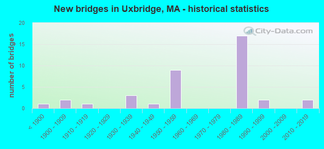
- New bridges - historical statistics
- 1Before 1900
- 21900-1909
- 11910-1919
- 31930-1939
- 11940-1949
- 91950-1959
- 171980-1989
- 21990-1999
- 22010-2019

- Reconstructed bridges - Historical Statistics
- 11940-1949
- 01950-1959
- 21960-1969
- 31970-1979
- 01980-1989
- 01990-1999
- 12000-2009
- 12010-2019


- Bridge Condition - Deck
- 3.2%Very good
- 29.0%Good
- 32.3%Satisfactory
- 32.3%Fair
- 3.2%Poor

- Bridge Condition - Superstructure
- 8.3%Very good
- 30.6%Good
- 38.9%Satisfactory
- 19.4%Fair
- 2.8%Poor

- Bridge Condition - Substructure
- 2.8%Very good
- 52.8%Good
- 33.3%Satisfactory
- 11.1%Fair

- Bridge Condition - Channel
- 25.0%Very good
- 40.0%Good
- 20.0%Satisfactory
- 15.0%Fair
Find on map >> Show street view
Structure Number: U02001B9NDOTNBI, Location: 2.2MI.NTH OF MILLVILLE TL (Lat: 42.054953, Lng: -71.616267), Route carried "on" structure: State highway 122, Year Built: 2012, Status: Open, Structure Length: 3.55m (11.65ft), Average Daily Traffic: 4,560 (year 2018), Truck Traffic: 7%, Design Load: HL 93, Features Intersected: WATER BLACKSTONE RIVER
Minimum Vertical Clearance: 99.00m (324.80ft), Kilometerpoint: 0.000, Lanes on structure: 2, Owner: State Highway Agency, Approaching Roadway Width: 12.1m (39.7ft), Skew: 1 degrees, Material/Design: Steel, Design/Construction: Stringer/Multi-beam, Number Of Spans In Main Unit: 1, Length of Maximum Span: 34.1m (111.9ft), Curb or Sidewalk Widths: Left: 2.0m (6.6ft), Right: 0.0m, Curb-To-Curb Width: 12.1m (39.7ft), Out-to-Out Width: 15.1m (49.5ft)
Condition: Deck: Good, Superstructure: Very good, Substructure: Good, Channel: Very good, Operating Rating: 48.6 metric tons, Method Used To Determine Operating Rating: Load and Resistance Factor Rating (LRFR) rating reported by rating factor(RF) method using HL-93 loadings, Inventory Rating: 42.1 metric tons, Method Used To Determine Inventory Rating: Load and Resistance Factor Rating (LRFR) rating reported by rating factor(RF) method using HL-93 loadings, Structural Evaluation: Better than present minimum criteria, Deck Geometry: Somewhat better than minimum adequacy, Waterway Adequacy: Equal to present desirable criteria, Approach Roadway Alignment: Better than present minimum criteria, Length Of Structure Improvement: 3.60m (11.81ft), Designated Inspection Frequency: Every 24 months, Inspection Date: Febuary 2021, Bridge Improvement Cost: $442,000, Roadway Improvement Cost: $45,000, Total Project Cost: $664,000 ( Estimate for 2022), Deck Structure Type: Concrete Precast Panels, Wearing Surface/Protective System: Wearing Surface: Bituminous, Membrane: Built-up, Deck Protection: Epoxy Coated Reinforcing
Find on map >> Show street view
Structure Number: U020081J2MUNNBI, Location: 0.1M E JCT RTS 16 & 122 (Lat: 42.075214, Lng: -71.625328), Route carried "on" structure: City street , Year Built: 1994, Status: Open, Structure Length: 2.47m (8.10ft), Average Daily Traffic: 780 (year 2013), Truck Traffic: 10%, Average Future Daily Traffic: 1,232 (year 2032), Design Load: HS 20, Features Intersected: WATER MUMFORD RIVER, Facility Carried by Structure: HWY DEPOT ST
Minimum Vertical Clearance: 30+ m (98+ ft), Kilometerpoint: 0.241, Lanes on structure: 2, Owner: Town or Township Highway Agency, Approaching Roadway Width: 7.9m (25.9ft), Material/Design: Prestressed concrete, Design/Construction: Box Beam or Girders - Multiple, Number Of Spans In Main Unit: 1, Length of Maximum Span: 22.9m (75.1ft), Curb-To-Curb Width: 7.9m (25.9ft), Out-to-Out Width: 10.7m (35.1ft)
Condition: Deck: Fair, Superstructure: Fair, Substructure: Good, Channel: Good, Operating Rating: 46.8 metric tons, Method Used To Determine Operating Rating: Allowable Stress (AS), Inventory Rating: 33.3 metric tons, Method Used To Determine Inventory Rating: Allowable Stress (AS), Structural Evaluation: Somewhat better than minimum adequacy, Deck Geometry: Somewhat better than minimum adequacy, Waterway Adequacy: Equal to present desirable criteria, Approach Roadway Alignment: Equal to present minimum criteria, Length Of Structure Improvement: 2.50m (8.20ft), Designated Inspection Frequency: Every 24 months, Inspection Date: September 2021, Bridge Improvement Cost: $1,051,000, Roadway Improvement Cost: $106,000, Total Project Cost: $1,577,000 ( Estimate for 2022), Deck Structure Type: Concrete Precast Panels, Wearing Surface/Protective System: Wearing Surface: Bituminous, Membrane: Preformed Fabric, Deck Protection: Epoxy Coated Reinforcing
Find on map >> Show street view
Structure Number: U020091LUDOTNBI, Location: .1 MI EAST OF ST 122 (Lat: 42.076606, Lng: -71.628283), Route carried "on" structure: State highway 16, Year Built: 1900, Status: Open, Structure Length: 1.52m (4.99ft), Average Daily Traffic: 11,277 (year 2020), Truck Traffic: 15%, Average Future Daily Traffic: 31,586 (year 2032), Features Intersected: WATER MUMFORD RIVER
Minimum Vertical Clearance: 30+ m (98+ ft), Kilometerpoint: 0.000, Lanes on structure: 2, Base Highway Network: Yes, Owner: State Highway Agency, Approaching Roadway Width: 10.7m (35.1ft), Material/Design: Masonry, Design/Construction: Arch - Deck, Number Of Spans In Main Unit: 1, Length of Maximum Span: 13.7m (44.9ft), Curb or Sidewalk Widths: Left: 2.5m (8.2ft), Right: 1.7m (5.6ft), Curb-To-Curb Width: 10.7m (35.1ft), Out-to-Out Width: 15.7m (51.5ft)
Condition: Superstructure: Good, Substructure: Good, Channel: Good, Operating Rating: 44.1 metric tons, Method Used To Determine Operating Rating: No rating analysis performed, Inventory Rating: 38.1 metric tons, Method Used To Determine Inventory Rating: Allowable Stress (AS), Structural Evaluation: Better than present minimum criteria, Deck Geometry: Meets minimum limits, Waterway Adequacy: Better than present minimum criteria, Approach Roadway Alignment: Better than present minimum criteria, Length Of Structure Improvement: 1.60m (5.25ft), Designated Inspection Frequency: Every 24 months, Inspection Date: July 2021, Bridge Improvement Cost: $408,000, Roadway Improvement Cost: $41,000, Total Project Cost: $613,000 ( Estimate for 2022)
Find on map >> Show street view
Structure Number: U020111LTDOTNBI, Location: .6 MI. E. OF ST-122 (Lat: 42.079817, Lng: -71.619628), Route carried "on" structure: State highway 16, Year Built: 1954, Status: Open, Structure Length: 2.41m (7.91ft), Average Daily Traffic: 10,742 (year 2018), Truck Traffic: 15%, Average Future Daily Traffic: 25,269 (year 2032), Design Load: H 20, Features Intersected: WATER BLACKSTONE RIVER
Minimum Vertical Clearance: 30+ m (98+ ft), Kilometerpoint: 23.351, Lanes on structure: 2, Base Highway Network: Yes, Owner: State Highway Agency, Approaching Roadway Width: 9.1m (29.9ft), Material/Design: Steel, Design/Construction: Stringer/Multi-beam, Number Of Spans In Main Unit: 1, Length of Maximum Span: 22.9m (75.1ft), Curb or Sidewalk Widths: Left: 1.8m (5.9ft), Right: 1.8m (5.9ft), Curb-To-Curb Width: 9.1m (29.9ft), Out-to-Out Width: 14.0m (45.9ft)
Condition: Deck: Fair, Superstructure: Satisfactory, Substructure: Satisfactory, Channel: Satisfactory, Operating Rating: 44.7 metric tons, Method Used To Determine Operating Rating: Allowable Stress (AS), Inventory Rating: 36.9 metric tons, Method Used To Determine Inventory Rating: Allowable Stress (AS), Structural Evaluation: Equal to present minimum criteria, Deck Geometry: High priority of corrective action, Waterway Adequacy: Better than present minimum criteria, Approach Roadway Alignment: Equal to present desirable criteria, Length Of Structure Improvement: 2.50m (8.20ft), Designated Inspection Frequency: Every 24 months, Underwater Inspection Frequency: Every 36 months, Inspection Date: September 2021, Underwater Inspection Date: April 2021, Bridge Improvement Cost: $2,114,000, Roadway Improvement Cost: $212,000, Total Project Cost: $3,172,000 ( Estimate for 2022), Deck Structure Type: Concrete Cast-file-Place, Wearing Surface/Protective System: Wearing Surface: Monolithic Concrete
Find on map >> Show street view
Structure Number: U020141J3MUNNBI, Location: .75 M S OF RT-16 (Lat: 42.070569, Lng: -71.608744), Route carried "on" structure: City street , Year Built: 1930, Status: Posted for load, Structure Length: 1.77m (5.81ft), Average Daily Traffic: 800 (year 2014), Truck Traffic: 2%, Average Future Daily Traffic: 1,263 (year 2031), Features Intersected: WATER WEST RIVER, Facility Carried by Structure: HWY HECLA ST
Minimum Vertical Clearance: 30+ m (98+ ft), Kilometerpoint: 0.418, Lanes on structure: 1, Owner: Town or Township Highway Agency, Approaching Roadway Width: 4.4m (14.4ft), Material/Design: Masonry, Design/Construction: Arch - Deck, Number Of Spans In Main Unit: 1, Length of Maximum Span: 9.8m (32.2ft), Curb-To-Curb Width: 4.2m (13.8ft), Out-to-Out Width: 7.5m (24.6ft)
Condition: Superstructure: Satisfactory, Substructure: Satisfactory, Channel: Good, Structural Evaluation: Equal to present minimum criteria, Deck Geometry: High priority of replacement, Waterway Adequacy: Equal to present desirable criteria, Approach Roadway Alignment: Better than present minimum criteria, Length Of Structure Improvement: 2.50m (8.20ft), Designated Inspection Frequency: Every 24 months, Inspection Date: June 2020, Bridge Improvement Cost: $2,030,000, Roadway Improvement Cost: $204,000, Total Project Cost: $3,046,000 ( Estimate for 2022)
Find on map >> Show street view
Structure Number: U020151J4MUNNBI, Location: @ COR. OF PATRICK HENRY R (Lat: 42.080828, Lng: -71.608447), Route carried "on" structure: City street , Year Built: 1930, Year Reconstructed: 1965, Status: Open, Structure Length: 1.07m (3.51ft), Average Daily Traffic: 780 (year 2014), Truck Traffic: 1%, Average Future Daily Traffic: 1,232 (year 2031), Features Intersected: WATER WEST RIVER, Facility Carried by Structure: HWY HENRY ST
Minimum Vertical Clearance: 30+ m (98+ ft), Kilometerpoint: 0.402, Lanes on structure: 2, Owner: Town or Township Highway Agency, Approaching Roadway Width: 5.8m (19.0ft), Material/Design: Prestressed concrete, Design/Construction: Slab, Number Of Spans In Main Unit: 1, Length of Maximum Span: 9.4m (30.8ft), Curb or Sidewalk Widths: Left: 0.0m, Right: 0.2m (0.7ft), Curb-To-Curb Width: 5.8m (19.0ft), Out-to-Out Width: 6.1m (20.0ft)
Condition: Deck: Satisfactory, Superstructure: Satisfactory, Substructure: Good, Channel: Good, Operating Rating: 59.0 metric tons, Method Used To Determine Operating Rating: Load Factor (LF), Inventory Rating: 32.7 metric tons, Method Used To Determine Inventory Rating: Load Factor (LF), Structural Evaluation: Equal to present minimum criteria, Deck Geometry: High priority of replacement, Waterway Adequacy: Better than present minimum criteria, Approach Roadway Alignment: Somewhat better than minimum adequacy, Length Of Structure Improvement: 1.10m (3.61ft), Designated Inspection Frequency: Every 24 months, Inspection Date: June 2020, Bridge Improvement Cost: $664,000, Roadway Improvement Cost: $67,000, Total Project Cost: $997,000 ( Estimate for 2022), Deck Structure Type: Concrete Precast Panels, Wearing Surface/Protective System: Wearing Surface: Bituminous
Find on map >> Show street view
Structure Number: U020161LRDOTNBI, Location: 1.1 MI. E. OF ST-122 (Lat: 42.083575, Lng: -71.607303), Route carried "on" structure: State highway 16, Year Built: 1912, Year Reconstructed: 1949, Status: Open, Structure Length: 0.94m (3.08ft), Average Daily Traffic: 8,887 (year 2020), Truck Traffic: 6%, Average Future Daily Traffic: 25,269 (year 2032), Features Intersected: WATER WEST RIVER
Minimum Vertical Clearance: 30+ m (98+ ft), Kilometerpoint: 24.220, Lanes on structure: 2, Base Highway Network: Yes, Owner: State Highway Agency, Approaching Roadway Width: 12.2m (40.0ft), Skew: 1 degrees, Material/Design: Masonry, Design/Construction: Arch - Deck, Number Of Spans In Main Unit: 1, Length of Maximum Span: 8.2m (26.9ft), Curb or Sidewalk Widths: Left: 1.4m (4.6ft), Right: 0.7m (2.3ft), Curb-To-Curb Width: 12.2m (40.0ft), Out-to-Out Width: 14.8m (48.6ft)
Condition: Superstructure: Good, Substructure: Satisfactory, Channel: Satisfactory, Structural Evaluation: Equal to present minimum criteria, Deck Geometry: Somewhat better than minimum adequacy, Waterway Adequacy: Equal to present desirable criteria, Approach Roadway Alignment: Equal to present desirable criteria, Length Of Structure Improvement: 1.00m (3.28ft), Designated Inspection Frequency: Every 24 months, Underwater Inspection Frequency: Every 36 months, Inspection Date: September 2021, Underwater Inspection Date: December 2020, Bridge Improvement Cost: $114,000, Roadway Improvement Cost: $12,000, Total Project Cost: $172,000 ( Estimate for 2022)
Find on map >> Show street view
Structure Number: U02017BWHMUNNBI, Location: 600' E OF CONNOR PASS (Lat: 42.100406, Lng: -71.601214), Route carried "on" structure: City street , Year Built: 1990, Status: Open, Structure Length: 0.61m (2.00ft), Average Daily Traffic: 5,773 (year 2015), Truck Traffic: 3%, Features Intersected: WATER WATER W RIVER, Facility Carried by Structure: HWY HWY E HARTFO
Minimum Vertical Clearance: 30+ m (98+ ft), Kilometerpoint: 3.653, Lanes on structure: 2, Owner: Town or Township Highway Agency, Approaching Roadway Width: 11.1m (36.4ft), Material/Design: Concrete, Design/Construction: Culvert, Number Of Spans In Main Unit: 2, Length of Maximum Span: 2.8m (9.2ft)
Condition: Channel: Good, Culverts: Satisfactory, Operating Rating: 88.2 metric tons, Method Used To Determine Operating Rating: Load Factor (LF), Inventory Rating: 52.8 metric tons, Method Used To Determine Inventory Rating: Load Factor (LF), Structural Evaluation: Equal to present minimum criteria, Waterway Adequacy: Superior to present desirable criteria, Approach Roadway Alignment: Somewhat better than minimum adequacy, Length Of Structure Improvement: 0.30m (0.98ft), Designated Inspection Frequency: Every 24 months, Inspection Date: June 2020, Bridge Improvement Cost: $172,000, Roadway Improvement Cost: $18,000, Total Project Cost: $259,000 ( Estimate for 2022), Deck Structure Type: Concrete Precast Panels
Find on map >> Show street view
Structure Number: U020181DLMUNNBI, Location: 400 FT. EAST OF OAK ST (Lat: 42.098375, Lng: -71.622306), Route carried "on" structure: City street , Year Built: 1900, Year Reconstructed: 1960, Status: Open, Structure Length: 1.19m (3.90ft), Average Daily Traffic: 8,085 (year 2019), Truck Traffic: 4%, Average Future Daily Traffic: 22,900 (year 2031), Features Intersected: WATER BLACKSTONE RIVER, Facility Carried by Structure: HWY HARTFORD AVE
Minimum Vertical Clearance: 30+ m (98+ ft), Kilometerpoint: 1.996, Lanes on structure: 2, Owner: Town or Township Highway Agency, Approaching Roadway Width: 6.4m (21.0ft), Material/Design: Masonry, Design/Construction: Arch - Deck, Number Of Spans In Main Unit: 1, Length of Maximum Span: 11.9m (39.0ft), Curb or Sidewalk Widths: Left: 0.2m (0.7ft), Right: 0.2m (0.7ft), Curb-To-Curb Width: 6.1m (20.0ft), Out-to-Out Width: 7.3m (24.0ft)
Condition: Superstructure: Good, Substructure: Good, Channel: Good, Structural Evaluation: Better than present minimum criteria, Deck Geometry: High priority of replacement, Waterway Adequacy: Equal to present minimum criteria, Approach Roadway Alignment: Equal to present desirable criteria, Length Of Structure Improvement: 1.20m (3.94ft), Designated Inspection Frequency: Every 24 months, Inspection Date: October 2020, Bridge Improvement Cost: $826,000, Roadway Improvement Cost: $83,000, Total Project Cost: $1,240,000 ( Estimate for 2022)
Find on map >> Show street view
Structure Number: U020191DKMUNNBI, Location: 200 FT E OF OAK ST (Lat: 42.098003, Lng: -71.623033), Route carried "on" structure: City street , Year Built: 1870, Status: Open, Structure Length: 1.83m (6.00ft), Average Daily Traffic: 8,093 (year 2017), Truck Traffic: 6%, Average Future Daily Traffic: 22,900 (year 2031), Features Intersected: WATER BLACKSTONE CANAL, Facility Carried by Structure: HWY HARTFORD AVE
Minimum Vertical Clearance: 30+ m (98+ ft), Kilometerpoint: 1.899, Lanes on structure: 2, Owner: Town or Township Highway Agency, Approaching Roadway Width: 6.4m (21.0ft), Material/Design: Masonry, Design/Construction: Arch - Deck, Number Of Spans In Main Unit: 1, Length of Maximum Span: 18.3m (60.0ft), Curb-To-Curb Width: 6.3m (20.7ft), Out-to-Out Width: 7.2m (23.6ft)
Condition: Superstructure: Satisfactory, Substructure: Fair, Channel: Good, Operating Rating: 44.1 metric tons, Method Used To Determine Operating Rating: No rating analysis performed, Inventory Rating: 37.7 metric tons, Method Used To Determine Inventory Rating: Allowable Stress (AS), Structural Evaluation: Somewhat better than minimum adequacy, Deck Geometry: High priority of replacement, Waterway Adequacy: Better than present minimum criteria, Approach Roadway Alignment: Equal to present minimum criteria, Length Of Structure Improvement: 1.90m (6.23ft), Designated Inspection Frequency: Every 24 months, Underwater Inspection Frequency: Every 36 months, Inspection Date: October 2020, Underwater Inspection Date: April 2021, Bridge Improvement Cost: $538,000, Roadway Improvement Cost: $54,000, Total Project Cost: $808,000 ( Estimate for 2022)
Find on map >> Show street view
Structure Number: U020201DMMUNNBI, Location: .4 MI E OF RTE 122 (Lat: 42.093128, Lng: -71.636131), Route carried "on" structure: City street , Year Built: 1955, Status: Posted for load, Structure Length: 1.49m (4.89ft), Average Daily Traffic: 8,085 (year 2019), Truck Traffic: 3%, Average Future Daily Traffic: 14,530 (year 2031), Design Load: H 20, Features Intersected: WATER MUMFORD RIVER, Facility Carried by Structure: HWY HARTFORD AVE
Minimum Vertical Clearance: 30+ m (98+ ft), Kilometerpoint: 0.612, Lanes on structure: 2, Owner: Town or Township Highway Agency, Approaching Roadway Width: 7.9m (25.9ft), Material/Design: Steel, Design/Construction: Stringer/Multi-beam, Number Of Spans In Main Unit: 1, Length of Maximum Span: 14.0m (45.9ft), Curb or Sidewalk Widths: Left: 1.6m (5.2ft), Right: 1.6m (5.2ft), Curb-To-Curb Width: 7.8m (25.6ft), Out-to-Out Width: 11.8m (38.7ft)
Condition: Deck: Fair, Superstructure: Fair, Substructure: Satisfactory, Channel: Fair, Operating Rating: 36.6 metric tons, Method Used To Determine Operating Rating: Allowable Stress (AS), Inventory Rating: 20.6 metric tons, Method Used To Determine Inventory Rating: Allowable Stress (AS), Structural Evaluation: Somewhat better than minimum adequacy, Deck Geometry: High priority of replacement, Waterway Adequacy: Better than present minimum criteria, Approach Roadway Alignment: Better than present minimum criteria, Length Of Structure Improvement: 1.50m (4.92ft), Designated Inspection Frequency: Every 24 months, Underwater Inspection Frequency: Every 36 months, Inspection Date: December 2020, Underwater Inspection Date: Febuary 2021, Bridge Improvement Cost: $696,000, Roadway Improvement Cost: $70,000, Total Project Cost: $1,045,000 ( Estimate for 2022), Deck Structure Type: Concrete Cast-file-Place, Wearing Surface/Protective System: Wearing Surface: Bituminous, Membrane: Built-up
Find on map >> Show street view
Structure Number: U020211L9DOTNBI, Location: .1 MI N OF HRTFD AV (Lat: 42.092242, Lng: -71.643144), Route carried "on" structure: State highway 122, Year Built: 1952, Status: Posted for load, Structure Length: 1.71m (5.61ft), Average Daily Traffic: 10,002 (year 2020), Truck Traffic: 6%, Average Future Daily Traffic: 19,267 (year 2033), Design Load: H 20, Features Intersected: WATER MUMFORD RIVER
Minimum Vertical Clearance: 30+ m (98+ ft), Kilometerpoint: 14.516, Lanes on structure: 2, Owner: State Highway Agency, Approaching Roadway Width: 12.2m (40.0ft), Material/Design: Steel, Design/Construction: Stringer/Multi-beam, Number Of Spans In Main Unit: 1, Length of Maximum Span: 16.2m (53.1ft), Curb or Sidewalk Widths: Left: 1.5m (4.9ft), Right: 1.5m (4.9ft), Curb-To-Curb Width: 12.2m (40.0ft), Out-to-Out Width: 16.2m (53.1ft)
Condition: Deck: Good, Superstructure: Satisfactory, Substructure: Good, Channel: Satisfactory, Operating Rating: 26.0 metric tons, Method Used To Determine Operating Rating: Load Factor (LF), Inventory Rating: 15.5 metric tons, Method Used To Determine Inventory Rating: Load Factor (LF), Structural Evaluation: High priority of corrective action, Deck Geometry: Somewhat better than minimum adequacy, Waterway Adequacy: Equal to present desirable criteria, Approach Roadway Alignment: Equal to present desirable criteria, Bridge Posting: Required (Relationship of Operating Rating to Maximum Legal Load: 10.0 - 19.9% below), Length Of Structure Improvement: 1.80m (5.91ft), Designated Inspection Frequency: Every 24 months, Underwater Inspection Frequency: Every 36 months, Inspection Date: November 2021, Underwater Inspection Date: March 2019, Bridge Improvement Cost: $1,146,000, Roadway Improvement Cost: $115,000, Total Project Cost: $1,720,000 ( Estimate for 2022), Deck Structure Type: Concrete Cast-file-Place, Wearing Surface/Protective System: Wearing Surface: Bituminous, Membrane: Preformed Fabric
Find on map >> Show street view
Structure Number: U0202422QDOT634, Location: 2 MI N OF MILVLL-UXBRG TL (Lat: 42.053858, Lng: -71.613239), Route carried "on" structure: State highway 122, Year Built: 1955, Year Reconstructed: 2016, Status: Open, Structure Length: 1.68m (5.51ft), Average Daily Traffic: 4,560 (year 2018), Truck Traffic: 7%, Average Future Daily Traffic: 6,159 (year 2033), Design Load: HL 93, Features Intersected: RR PWRR
Minimum Vertical Clearance: 30+ m (98+ ft), Kilometerpoint: 9.315, Lanes on structure: 2, Owner: State Highway Agency, Approaching Roadway Width: 14.9m (48.9ft), Skew: 4 degrees, Material/Design: Steel, Design/Construction: Stringer/Multi-beam, Number Of Spans In Main Unit: 1, Length of Maximum Span: 14.9m (48.9ft), Curb or Sidewalk Widths: Left: 1.8m (5.9ft), Right: 0.0m, Curb-To-Curb Width: 13.1m (43.0ft), Out-to-Out Width: 15.7m (51.5ft)
Condition: Deck: Very good, Superstructure: Very good, Substructure: Good, Operating Rating: 55.1 metric tons, Method Used To Determine Operating Rating: Load and Resistance Factor Rating (LRFR) rating reported by rating factor(RF) method using HL-93 loadings, Inventory Rating: 42.1 metric tons, Method Used To Determine Inventory Rating: Load and Resistance Factor Rating (LRFR) rating reported by rating factor(RF) method using HL-93 loadings, Structural Evaluation: Better than present minimum criteria, Underclear: High priority of corrective action, Approach Roadway Alignment: Equal to present desirable criteria, Designated Inspection Frequency: Every 24 months, Inspection Date: October 2020, Deck Structure Type: Concrete Cast-file-Place, Wearing Surface/Protective System: Wearing Surface: Monolithic Concrete, Membrane: Built-up
Find on map >> Show street view
Structure Number: U02030BAMMUNNBI, Location: BTWN 146A&122 NR MILLVILL (Lat: 42.029858, Lng: -71.603242), Route carried "on" structure: City street , Year Built: 2011, Status: Open, Structure Length: 1.52m (4.99ft), Average Daily Traffic: 2,700 (year 2013), Truck Traffic: 1%, Design Load: HL 93, Features Intersected: WATER WATER BACON BROOK, Facility Carried by Structure: HWY RIVER RD
Minimum Vertical Clearance: 30+ m (98+ ft), Kilometerpoint: 1.835, Lanes on structure: 2, Owner: Town or Township Highway Agency, Approaching Roadway Width: 10.7m (35.1ft), Material/Design: Steel, Design/Construction: Stringer/Multi-beam, Number Of Spans In Main Unit: 1, Length of Maximum Span: 14.0m (45.9ft), Curb-To-Curb Width: 9.7m (31.8ft), Out-to-Out Width: 10.7m (35.1ft)
Condition: Deck: Good, Superstructure: Very good, Substructure: Very good, Channel: Good, Operating Rating: 90.7 metric tons, Method Used To Determine Operating Rating: Load and Resistance Factor Rating (LRFR) rating reported by rating factor(RF) method using HL-93 loadings, Inventory Rating: 71.3 metric tons, Method Used To Determine Inventory Rating: Load and Resistance Factor Rating (LRFR) rating reported by rating factor(RF) method using HL-93 loadings, Structural Evaluation: Equal to present desirable criteria, Deck Geometry: Meets minimum limits, Waterway Adequacy: Superior to present desirable criteria, Approach Roadway Alignment: Better than present minimum criteria, Length Of Structure Improvement: 1.60m (5.25ft), Designated Inspection Frequency: Every 24 months, Inspection Date: March 2021, Bridge Improvement Cost: $559,000, Roadway Improvement Cost: $56,000, Total Project Cost: $839,000 ( Estimate for 2022), Deck Structure Type: Concrete Precast Panels, Wearing Surface/Protective System: Wearing Surface: Monolithic Concrete, Membrane: Epoxy, Deck Protection: Epoxy Coated Reinforcing
Find on map >> Show street view
Structure Number: U020361L8DOTNBI, Location: 1 MILE WEST OF ST. 122 (Lat: 42.028733, Lng: -71.607325), Route carried "on" structure: State highway 146A, Year Built: 1931, Status: Open, Structure Length: 0.79m (2.59ft), Average Daily Traffic: 7,511 (year 2019), Truck Traffic: 13%, Average Future Daily Traffic: 10,897 (year 2032), Design Load: H 20, Features Intersected: WATER BACON BROOK, Facility Carried by Structure: ST146 A/QUAKER HWY
Minimum Vertical Clearance: 30+ m (98+ ft), Kilometerpoint: 2.092, Lanes on structure: 2, Owner: State Highway Agency, Approaching Roadway Width: 12.5m (41.0ft), Skew: 2 degrees, Material/Design: Concrete, Design/Construction: Tee Beam, Number Of Spans In Main Unit: 1, Length of Maximum Span: 7.0m (23.0ft), Curb or Sidewalk Widths: Left: 0.5m (1.6ft), Right: 0.5m (1.6ft), Curb-To-Curb Width: 12.2m (40.0ft), Out-to-Out Width: 13.3m (43.6ft)
Condition: Deck: Fair, Superstructure: Satisfactory, Substructure: Satisfactory, Channel: Satisfactory, Operating Rating: 67.2 metric tons, Method Used To Determine Operating Rating: Load Factor (LF), Inventory Rating: 40.5 metric tons, Method Used To Determine Inventory Rating: Load Factor (LF), Structural Evaluation: Equal to present minimum criteria, Deck Geometry: Somewhat better than minimum adequacy, Waterway Adequacy: Better than present minimum criteria, Approach Roadway Alignment: Equal to present desirable criteria, Length Of Structure Improvement: 0.80m (2.62ft), Designated Inspection Frequency: Every 24 months, Inspection Date: January 2021, Bridge Improvement Cost: $425,000, Roadway Improvement Cost: $43,000, Total Project Cost: $638,000 ( Estimate for 2022), Deck Structure Type: Concrete Cast-file-Place, Wearing Surface/Protective System: Wearing Surface: Bituminous, Membrane: Built-up
Find on map >> Show street view
Structure Number: U020401MVDOTNBI, Location: 1 MI. N. OF HARTFORD AVE (Lat: 42.089633, Lng: -71.695164), Route carried "on" structure: State highway 146, Year Built: 1950, Year Reconstructed: 1983, Status: Open, Structure Length: 2.83m (9.28ft), Average Daily Traffic: 18,935 (year 2016), Truck Traffic: 15%, Average Future Daily Traffic: 20,531 (year 2033), Design Load: H 20, Features Intersected: HWY LACKEY DAM RD
Minimum Vertical Clearance: 30+ m (98+ ft), Kilometerpoint: 12.601, Lanes on structure: 2, Lanes under structure: 2, Base Highway Network: Yes, Owner: State Highway Agency, Approaching Roadway Width: 13.7m (44.9ft), Skew: 5 degrees, Material/Design: Steel, Design/Construction: Stringer/Multi-beam, Number Of Spans In Main Unit: 1, Length of Maximum Span: 24.7m (81.0ft), Curb-To-Curb Width: 13.7m (44.9ft), Out-to-Out Width: 14.6m (47.9ft)
Condition: Deck: Fair, Superstructure: Satisfactory, Substructure: Satisfactory, Operating Rating: 86.4 metric tons, Method Used To Determine Operating Rating: Load Factor (LF), Inventory Rating: 51.7 metric tons, Method Used To Determine Inventory Rating: Load Factor (LF), Structural Evaluation: Equal to present minimum criteria, Deck Geometry: Superior to present desirable criteria, Underclear: Meets minimum limits, Approach Roadway Alignment: Equal to present desirable criteria, Length Of Structure Improvement: 2.90m (9.51ft), Designated Inspection Frequency: Every 24 months, Inspection Date: March 2020, Bridge Improvement Cost: $799,000, Roadway Improvement Cost: $80,000, Total Project Cost: $1,199,000 ( Estimate for 2022), Deck Structure Type: Concrete Cast-file-Place, Wearing Surface/Protective System: Wearing Surface: Bituminous, Membrane: Built-up
Find on map >> Show street view
Structure Number: U020411MUDOTNBI, Location: 1.6 M N OF ST-16 (Lat: 42.083000, Lng: -71.689683), Route carried "on" structure: State highway 146, Year Built: 1950, Status: Open, Structure Length: 2.52m (8.27ft), Average Daily Traffic: 17,501 (year 2017), Truck Traffic: 15%, Average Future Daily Traffic: 22,426 (year 2031), Design Load: H 20, Features Intersected: WATER MUMFORD RIVER
Minimum Vertical Clearance: 30+ m (98+ ft), Kilometerpoint: 12.070, Lanes on structure: 2, Base Highway Network: Yes, Owner: State Highway Agency, Approaching Roadway Width: 12.5m (41.0ft), Skew: 2 degrees, Material/Design: Steel, Design/Construction: Stringer/Multi-beam, Number Of Spans In Main Unit: 1, Length of Maximum Span: 23.7m (77.8ft), Curb-To-Curb Width: 12.5m (41.0ft), Out-to-Out Width: 15.4m (50.5ft)
Condition: Deck: Fair, Superstructure: Fair, Substructure: Fair, Channel: Fair, Operating Rating: 38.2 metric tons, Method Used To Determine Operating Rating: Load Factor (LF), Inventory Rating: 22.9 metric tons, Method Used To Determine Inventory Rating: Load Factor (LF), Structural Evaluation: Somewhat better than minimum adequacy, Deck Geometry: Better than present minimum criteria, Waterway Adequacy: Equal to present desirable criteria, Approach Roadway Alignment: Equal to present desirable criteria, Length Of Structure Improvement: 2.60m (8.53ft), Designated Inspection Frequency: Every 24 months, Inspection Date: August 2020, Bridge Improvement Cost: $1,573,000, Roadway Improvement Cost: $158,000, Total Project Cost: $2,360,000 ( Estimate for 2022), Deck Structure Type: Concrete Cast-file-Place, Wearing Surface/Protective System: Wearing Surface: Bituminous, Membrane: Built-up
Find on map >> Show street view
Structure Number: U020421LVDOTNBI, Location: .3 MI W OF MENDON TL (Lat: 42.090181, Lng: -71.597731), Route carried "on" structure: State highway 16, Year Built: 1949, Year Reconstructed: 2006, Status: Open, Structure Length: 0.79m (2.59ft), Average Daily Traffic: 10,594 (year 2017), Truck Traffic: 10%, Average Future Daily Traffic: 20,531 (year 2031), Features Intersected: WATER ROCK MEADOW BROOK
Minimum Vertical Clearance: 30+ m (98+ ft), Kilometerpoint: 26.594, Lanes on structure: 2, Base Highway Network: Yes, Owner: State Highway Agency, Approaching Roadway Width: 9.8m (32.2ft), Skew: 1 degrees, Material/Design: Steel, Design/Construction: Culvert, Number Of Spans In Main Unit: 2, Length of Maximum Span: 3.4m (11.2ft)
Condition: Channel: Fair, Culverts: Satisfactory, Structural Evaluation: Equal to present minimum criteria, Waterway Adequacy: Equal to present desirable criteria, Approach Roadway Alignment: Equal to present desirable criteria, Length Of Structure Improvement: 0.40m (1.31ft), Designated Inspection Frequency: Every 24 months, Inspection Date: December 2020, Bridge Improvement Cost: $294,000, Roadway Improvement Cost: $30,000, Total Project Cost: $442,000 ( Estimate for 2022)
Find on map >> Show street view
Structure Number: U020431YKDOTNBI, Location: 1MI.NTH.OF ST-16 (Lat: 42.076772, Lng: -71.682600), Route carried "on" structure: City street , Year Built: 1950, Year Reconstructed: 1983, Status: Open, Structure Length: 3.17m (10.40ft), Average Daily Traffic: 5,849 (year 2020), Truck Traffic: 6%, Average Future Daily Traffic: 2,685 (year 2032), Design Load: H 20, Features Intersected: ST146 NB, Facility Carried by Structure: HWY W HARTFRD AV
Minimum Vertical Clearance: 30+ m (98+ ft), Kilometerpoint: 10.975, Lanes on structure: 2, Lanes under structure: 2, Owner: State Highway Agency, Approaching Roadway Width: 11.0m (36.1ft), Material/Design: Steel continuous, Design/Construction: Stringer/Multi-beam, Number Of Spans In Main Unit: 2, Length of Maximum Span: 15.2m (49.9ft), Curb or Sidewalk Widths: Left: 1.5m (4.9ft), Right: 0.3m (1.0ft), Curb-To-Curb Width: 11.0m (36.1ft), Out-to-Out Width: 13.7m (44.9ft)
Condition: Deck: Satisfactory, Superstructure: Fair, Substructure: Fair, Operating Rating: 55.6 metric tons, Method Used To Determine Operating Rating: Load Factor (LF), Inventory Rating: 33.3 metric tons, Method Used To Determine Inventory Rating: Load Factor (LF), Structural Evaluation: Somewhat better than minimum adequacy, Deck Geometry: Meets minimum limits, Underclear: Meets minimum limits, Approach Roadway Alignment: Equal to present desirable criteria, Length Of Structure Improvement: 3.20m (10.50ft), Designated Inspection Frequency: Every 24 months, Inspection Date: May 2021, Bridge Improvement Cost: $1,723,000, Roadway Improvement Cost: $173,000, Total Project Cost: $2,585,000 ( Estimate for 2022), Deck Structure Type: Concrete Cast-file-Place, Wearing Surface/Protective System: Wearing Surface: Bituminous, Membrane: Built-up
Find on map >> Show street view
Structure Number: U020461MTDOTNBI, Location: 2 MILES WEST OF ST-122 (Lat: 42.067275, Lng: -71.665850), Route carried "on" structure: State highway 146, Year Built: 1950, Status: Open, Structure Length: 1.52m (4.99ft), Average Daily Traffic: 17,474 (year 2019), Truck Traffic: 11%, Average Future Daily Traffic: 23,690 (year 2032), Design Load: H 20, Features Intersected: ST 16 DOUGLAS ST
Minimum Vertical Clearance: 30+ m (98+ ft), Kilometerpoint: 9.093, Lanes on structure: 2, Lanes under structure: 2, Base Highway Network: Yes, Owner: State Highway Agency, Approaching Roadway Width: 13.4m (44.0ft), Skew: 1 degrees, Material/Design: Steel, Design/Construction: Stringer/Multi-beam, Number Of Spans In Main Unit: 1, Length of Maximum Span: 12.8m (42.0ft), Curb-To-Curb Width: 13.3m (43.6ft), Out-to-Out Width: 14.2m (46.6ft)
Condition: Deck: Satisfactory, Superstructure: Fair, Substructure: Good, Operating Rating: 50.1 metric tons, Method Used To Determine Operating Rating: Load Factor (LF), Inventory Rating: 30.0 metric tons, Method Used To Determine Inventory Rating: Load Factor (LF), Structural Evaluation: Somewhat better than minimum adequacy, Deck Geometry: Superior to present desirable criteria, Underclear: Meets minimum limits, Approach Roadway Alignment: Equal to present desirable criteria, Length Of Structure Improvement: 1.60m (5.25ft), Designated Inspection Frequency: Every 24 months, Inspection Date: January 2021, Bridge Improvement Cost: $893,000, Roadway Improvement Cost: $90,000, Total Project Cost: $1,340,000 ( Estimate for 2022), Deck Structure Type: Concrete Cast-file-Place, Wearing Surface/Protective System: Wearing Surface: Bituminous, Membrane: Built-up
Find on map >> Show street view
Structure Number: U0204720YDOTNBI, Location: 4 MI NO OF RHODE IS. S.L. (Lat: 42.060811, Lng: -71.650792), Route carried "on" structure: City street , Year Built: 1950, Year Reconstructed: 1984, Status: Open, Structure Length: 6.73m (22.08ft), Average Daily Traffic: 13,949 (year 2020), Truck Traffic: 10%, Average Future Daily Traffic: 395 (year 2032), Design Load: HS 20, Features Intersected: ST146 NB, Facility Carried by Structure: HWY POND ST
Minimum Vertical Clearance: 30+ m (98+ ft), Kilometerpoint: 2.012, Lanes on structure: 2, Lanes under structure: 2, Owner: State Highway Agency, Approaching Roadway Width: 9.1m (29.9ft), Skew: 3 degrees, Material/Design: Steel, Design/Construction: Stringer/Multi-beam, Number Of Spans In Main Unit: 4, Length of Maximum Span: 18.6m (61.0ft), Curb or Sidewalk Widths: Left: 0.2m (0.7ft), Right: 0.2m (0.7ft), Curb-To-Curb Width: 9.1m (29.9ft), Out-to-Out Width: 10.4m (34.1ft)
Condition: Deck: Good, Superstructure: Fair, Substructure: Satisfactory, Operating Rating: 39.3 metric tons, Method Used To Determine Operating Rating: Load Factor (LF), Inventory Rating: 23.5 metric tons, Method Used To Determine Inventory Rating: Load Factor (LF), Structural Evaluation: Somewhat better than minimum adequacy, Deck Geometry: Meets minimum limits, Underclear: Meets minimum limits, Approach Roadway Alignment: Equal to present desirable criteria, Length Of Structure Improvement: 6.80m (22.31ft), Designated Inspection Frequency: Every 24 months, Inspection Date: April 2021, Bridge Improvement Cost: $2,789,000, Roadway Improvement Cost: $279,000, Total Project Cost: $4,184,000 ( Estimate for 2022), Deck Structure Type: Concrete Cast-file-Place, Wearing Surface/Protective System: Wearing Surface: Bituminous, Membrane: Built-up
Find on map >> Show street view
Structure Number: U0204820RDOTNBI, Location: .5 MI.WST.OF ST.146A (Lat: 42.050486, Lng: -71.632142), Route carried "on" structure: City street , Year Built: 1984, Status: Open, Structure Length: 5.70m (18.70ft), Average Daily Traffic: 312 (year 2018), Truck Traffic: 1%, Average Future Daily Traffic: 632 (year 2032), Design Load: HS 20, Features Intersected: ST146, Facility Carried by Structure: HWY MILL ST
Minimum Vertical Clearance: 30+ m (98+ ft), Kilometerpoint: 0.805, Lanes on structure: 2, Lanes under structure: 4, Owner: State Highway Agency, Approaching Roadway Width: 9.8m (32.2ft), Material/Design: Steel continuous, Design/Construction: Stringer/Multi-beam, Number Of Spans In Main Unit: 2, Length of Maximum Span: 27.7m (90.9ft), Curb or Sidewalk Widths: Left: 1.9m (6.2ft), Right: 0.6m (2.0ft), Curb-To-Curb Width: 9.8m (32.2ft), Out-to-Out Width: 12.3m (40.4ft)
Condition: Deck: Good, Superstructure: Good, Substructure: Good, Operating Rating: 67.7 metric tons, Method Used To Determine Operating Rating: Load Factor (LF), Inventory Rating: 39.5 metric tons, Method Used To Determine Inventory Rating: Load Factor (LF), Structural Evaluation: Better than present minimum criteria, Deck Geometry: Better than present minimum criteria, Underclear: Superior to present desirable criteria, Approach Roadway Alignment: Equal to present desirable criteria, Length Of Structure Improvement: 5.80m (19.03ft), Designated Inspection Frequency: Every 24 months, Inspection Date: April 2021, Bridge Improvement Cost: $657,000, Roadway Improvement Cost: $66,000, Total Project Cost: $986,000 ( Estimate for 2022), Deck Structure Type: Concrete Cast-file-Place, Wearing Surface/Protective System: Wearing Surface: Bituminous, Membrane: Built-up
Find on map >> Show street view
Structure Number: U0205122PDOT634, Location: .2 MI EAST OF ST 122 (Lat: 42.083569, Lng: -71.636144), Route carried "on" structure: City street , Year Built: 1983, Status: Posted for load, Structure Length: 1.52m (4.99ft), Average Daily Traffic: 600 (year 2014), Truck Traffic: 1%, Average Future Daily Traffic: 948 (year 2033), Design Load: H 20, Features Intersected: RR PWRR, Facility Carried by Structure: HWY HOMEWARD AVE
Minimum Vertical Clearance: 30+ m (98+ ft), Kilometerpoint: 0.322, Lanes on structure: 2, Owner: State Highway Agency, Approaching Roadway Width: 10.4m (34.1ft), Skew: 1 degrees, Material/Design: Prestressed concrete, Design/Construction: Slab, Number Of Spans In Main Unit: 1, Length of Maximum Span: 14.0m (45.9ft), Curb or Sidewalk Widths: Left: 1.5m (4.9ft), Right: 1.5m (4.9ft), Curb-To-Curb Width: 8.6m (28.2ft), Out-to-Out Width: 12.4m (40.7ft)
Condition: Deck: Poor, Superstructure: Poor, Substructure: Satisfactory, Operating Rating: 12.8 metric tons, Method Used To Determine Operating Rating: Load Factor (LF), Inventory Rating: 5.4 metric tons, Method Used To Determine Inventory Rating: Load Factor (LF), Structural Evaluation: High priority of replacement, Deck Geometry: Somewhat better than minimum adequacy, Underclear: High priority of replacement, Approach Roadway Alignment: Better than present minimum criteria, Bridge Posting: Required (Relationship of Operating Rating to Maximum Legal Load: > 39.9% below), Length Of Structure Improvement: 2.20m (7.22ft), Designated Inspection Frequency: Every 12 months, Other Special Inspection Frequency: Every 12 months, Inspection Date: March 2022, Other Special Inspection Date: March 2022, Bridge Improvement Cost: $1,844,000, Roadway Improvement Cost: $185,000, Total Project Cost: $2,767,000 ( Estimate for 2022), Deck Structure Type: Concrete Precast Panels, Wearing Surface/Protective System: Wearing Surface: Bituminous, Membrane: Built-up
Find on map >> Show street view
Structure Number: U020521MWDOTNBI, Location: 2.6 MI. S. OF ST-16 (Lat: 42.046375, Lng: -71.629372), Route carried "on" structure: Ramp State highway 146, Year Built: 1984, Status: Open, Structure Length: 2.13m (6.99ft), Average Daily Traffic: 1,652 (year 2019), Truck Traffic: 5%, Average Future Daily Traffic: 1,579 (year 2032), Design Load: HS 20, Features Intersected: WATER EMERSON BROOK
Minimum Vertical Clearance: 30+ m (98+ ft), Kilometerpoint: 5.150, Lanes on structure: 1, Base Highway Network: Yes, Owner: State Highway Agency, Approaching Roadway Width: 7.9m (25.9ft), Material/Design: Prestressed concrete, Design/Construction: Box Beam or Girders - Multiple, Number Of Spans In Main Unit: 1, Length of Maximum Span: 18.9m (62.0ft), Curb-To-Curb Width: 7.9m (25.9ft), Out-to-Out Width: 8.8m (28.9ft)
Condition: Deck: Fair, Superstructure: Fair, Substructure: Good, Channel: Very good, Operating Rating: 31.9 metric tons, Method Used To Determine Operating Rating: Load Factor (LF), Inventory Rating: 17.7 metric tons, Method Used To Determine Inventory Rating: Load Factor (LF), Structural Evaluation: Meets minimum limits, Deck Geometry: Equal to present desirable criteria, Waterway Adequacy: Superior to present desirable criteria, Approach Roadway Alignment: Equal to present desirable criteria, Bridge Posting: Required (Relationship of Operating Rating to Maximum Legal Load: 0.1 - 9.9% below), Length Of Structure Improvement: 2.20m (7.22ft), Designated Inspection Frequency: Every 24 months, Inspection Date: January 2021, Bridge Improvement Cost: $761,000, Roadway Improvement Cost: $77,000, Total Project Cost: $1,142,000 ( Estimate for 2022), Deck Structure Type: Concrete Precast Panels, Wearing Surface/Protective System: Wearing Surface: Bituminous, Membrane: Built-up
Find on map >> Show street view
Structure Number: U020531MXDOTNBI, Location: 2.6 MI. S. OF ST-16 (Lat: 42.046186, Lng: -71.627689), Route carried "on" structure: State highway 146, Year Built: 1984, Status: Open, Structure Length: 7.01m (23.00ft), Average Daily Traffic: 14,584 (year 2020), Truck Traffic: 15%, Average Future Daily Traffic: 28,427 (year 2032), Design Load: HS 20, Features Intersected: COMB CHOCLG RD&EMRSN BK
Minimum Vertical Clearance: 30+ m (98+ ft), Kilometerpoint: 5.150, Lanes on structure: 3, Lanes under structure: 2, Base Highway Network: Yes, Owner: State Highway Agency, Approaching Roadway Width: 12.8m (42.0ft), Skew: 2 degrees, Material/Design: Steel continuous, Design/Construction: Stringer/Multi-beam, Number Of Spans In Main Unit: 2, Length of Maximum Span: 34.4m (112.9ft), Curb or Sidewalk Widths: Left: 0.2m (0.7ft), Right: 0.2m (0.7ft), Curb-To-Curb Width: 12.8m (42.0ft), Out-to-Out Width: 13.7m (44.9ft)
Condition: Deck: Fair, Superstructure: Satisfactory, Substructure: Fair, Channel: Very good, Operating Rating: 61.4 metric tons, Method Used To Determine Operating Rating: Load Factor (LF), Inventory Rating: 36.8 metric tons, Method Used To Determine Inventory Rating: Load Factor (LF), Structural Evaluation: Somewhat better than minimum adequacy, Deck Geometry: Meets minimum limits, Underclear: Meets minimum limits, Waterway Adequacy: Superior to present desirable criteria, Approach Roadway Alignment: Equal to present desirable criteria, Length Of Structure Improvement: 7.10m (23.29ft), Designated Inspection Frequency: Every 24 months, Inspection Date: August 2021, Bridge Improvement Cost: $3,821,000, Roadway Improvement Cost: $383,000, Total Project Cost: $5,732,000 ( Estimate for 2022), Deck Structure Type: Concrete Cast-file-Place, Wearing Surface/Protective System: Wearing Surface: Bituminous, Membrane: Built-up
Find on map >> Show street view
Structure Number: U020531MYDOTNBI, Location: 2.6 MI. S. OF ST-16 (Lat: 42.046164, Lng: -71.628097), Route carried "on" structure: State highway 146, Year Built: 1984, Status: Open, Structure Length: 7.01m (23.00ft), Average Daily Traffic: 18,612 (year 2018), Truck Traffic: 11%, Average Future Daily Traffic: 28,427 (year 2032), Design Load: HS 20, Features Intersected: COMB CHOCLG RD&EMRSN BK
Minimum Vertical Clearance: 30+ m (98+ ft), Kilometerpoint: 5.150, Lanes on structure: 2, Lanes under structure: 2, Base Highway Network: Yes, Owner: State Highway Agency, Approaching Roadway Width: 12.8m (42.0ft), Skew: 2 degrees, Material/Design: Steel continuous, Design/Construction: Stringer/Multi-beam, Number Of Spans In Main Unit: 2, Length of Maximum Span: 34.4m (112.9ft), Curb-To-Curb Width: 12.8m (42.0ft), Out-to-Out Width: 13.7m (44.9ft)
Condition: Deck: Satisfactory, Superstructure: Good, Substructure: Good, Channel: Very good, Operating Rating: 61.5 metric tons, Method Used To Determine Operating Rating: Load Factor (LF), Inventory Rating: 36.8 metric tons, Method Used To Determine Inventory Rating: Load Factor (LF), Structural Evaluation: Better than present minimum criteria, Deck Geometry: Equal to present desirable criteria, Underclear: Meets minimum limits, Waterway Adequacy: Superior to present desirable criteria, Approach Roadway Alignment: Equal to present desirable criteria, Length Of Structure Improvement: 7.10m (23.29ft), Designated Inspection Frequency: Every 24 months, Inspection Date: August 2021, Bridge Improvement Cost: $383,000, Roadway Improvement Cost: $39,000, Total Project Cost: $575,000 ( Estimate for 2022), Deck Structure Type: Concrete Cast-file-Place, Wearing Surface/Protective System: Wearing Surface: Bituminous, Membrane: Built-up
Find on map >> Show street view
Structure Number: U020541N0DOTNBI, Location: .1 MI.WEST OF ST.146A (Lat: 42.039028, Lng: -71.622803), Route carried "on" structure: State highway 146, Year Built: 1984, Status: Open, Structure Length: 2.85m (9.35ft), Average Daily Traffic: 17,364 (year 2019), Truck Traffic: 4%, Average Future Daily Traffic: 28,427 (year 2032), Design Load: HS 20, Features Intersected: ST 98 ALDRICH ST
Minimum Vertical Clearance: 30+ m (98+ ft), Kilometerpoint: 4.184, Lanes on structure: 3, Lanes under structure: 2, Base Highway Network: Yes, Owner: State Highway Agency, Approaching Roadway Width: 12.8m (42.0ft), Skew: 2 degrees, Material/Design: Prestressed concrete, Design/Construction: Stringer/Multi-beam, Number Of Spans In Main Unit: 1, Length of Maximum Span: 26.5m (86.9ft), Curb-To-Curb Width: 12.8m (42.0ft), Out-to-Out Width: 14.0m (45.9ft)
Condition: Deck: Good, Superstructure: Satisfactory, Substructure: Satisfactory, Operating Rating: 64.8 metric tons, Method Used To Determine Operating Rating: Load Factor (LF), Inventory Rating: 47.1 metric tons, Method Used To Determine Inventory Rating: Load Factor (LF), Structural Evaluation: Equal to present minimum criteria, Deck Geometry: High priority of replacement, Underclear: Meets minimum limits, Approach Roadway Alignment: Equal to present desirable criteria, Length Of Structure Improvement: 2.90m (9.51ft), Designated Inspection Frequency: Every 24 months, Inspection Date: January 2021, Bridge Improvement Cost: $1,532,000, Roadway Improvement Cost: $154,000, Total Project Cost: $2,299,000 ( Estimate for 2022), Deck Structure Type: Concrete Cast-file-Place, Wearing Surface/Protective System: Wearing Surface: Bituminous, Membrane: Built-up
Find on map >> Show street view
Structure Number: U020541N1DOTNBI, Location: .1 MI. WEST OF ST-146A (Lat: 42.038819, Lng: -71.623072), Route carried "on" structure: State highway 146, Year Built: 1984, Status: Open, Structure Length: 2.87m (9.42ft), Average Daily Traffic: 16,378 (year 2019), Truck Traffic: 4%, Average Future Daily Traffic: 28,427 (year 2032), Design Load: HS 20, Features Intersected: ST 98 ALDRICH ST
Minimum Vertical Clearance: 30+ m (98+ ft), Kilometerpoint: 4.184, Lanes on structure: 2, Lanes under structure: 2, Base Highway Network: Yes, Owner: State Highway Agency, Approaching Roadway Width: 12.8m (42.0ft), Skew: 2 degrees, Material/Design: Prestressed concrete, Design/Construction: Stringer/Multi-beam, Number Of Spans In Main Unit: 1, Length of Maximum Span: 25.9m (85.0ft), Curb-To-Curb Width: 12.8m (42.0ft), Out-to-Out Width: 13.7m (44.9ft)
Condition: Deck: Fair, Superstructure: Good, Substructure: Good, Operating Rating: 64.8 metric tons, Method Used To Determine Operating Rating: Load Factor (LF), Inventory Rating: 47.1 metric tons, Method Used To Determine Inventory Rating: Load Factor (LF), Structural Evaluation: Better than present minimum criteria, Deck Geometry: Equal to present desirable criteria, Underclear: Meets minimum limits, Approach Roadway Alignment: Equal to present desirable criteria, Length Of Structure Improvement: 2.90m (9.51ft), Designated Inspection Frequency: Every 24 months, Inspection Date: January 2021, Bridge Improvement Cost: $749,000, Roadway Improvement Cost: $75,000, Total Project Cost: $1,124,000 ( Estimate for 2022), Deck Structure Type: Concrete Cast-file-Place, Wearing Surface/Protective System: Wearing Surface: Bituminous, Membrane: Built-up
Find on map >> Show street view
Structure Number: U020551N2DOTNBI, Location: .5 MI N OF RTE 146-A (Lat: 42.027414, Lng: -71.610831), Route carried "on" structure: State highway 146, Year Built: 1984, Status: Open, Structure Length: 2.90m (9.51ft), Average Daily Traffic: 17,288 (year 2018), Truck Traffic: 6%, Average Future Daily Traffic: 31,586 (year 2032), Design Load: HS 20, Features Intersected: HWY ELMWOOD AVE
Minimum Vertical Clearance: 30+ m (98+ ft), Kilometerpoint: 2.414, Lanes on structure: 3, Lanes under structure: 2, Base Highway Network: Yes, Owner: State Highway Agency, Approaching Roadway Width: 12.8m (42.0ft), Skew: 2 degrees, Material/Design: Prestressed concrete, Design/Construction: Stringer/Multi-beam, Number Of Spans In Main Unit: 1, Length of Maximum Span: 26.5m (86.9ft), Curb-To-Curb Width: 12.8m (42.0ft), Out-to-Out Width: 13.7m (44.9ft)
Condition: Deck: Satisfactory, Superstructure: Satisfactory, Substructure: Good, Operating Rating: 57.3 metric tons, Method Used To Determine Operating Rating: Load Factor (LF), Inventory Rating: 31.4 metric tons, Method Used To Determine Inventory Rating: Load Factor (LF), Structural Evaluation: Equal to present minimum criteria, Deck Geometry: High priority of replacement, Underclear: Meets minimum limits, Approach Roadway Alignment: Equal to present desirable criteria, Length Of Structure Improvement: 3.00m (9.84ft), Designated Inspection Frequency: Every 24 months, Inspection Date: April 2021, Bridge Improvement Cost: $1,615,000, Roadway Improvement Cost: $162,000, Total Project Cost: $2,423,000 ( Estimate for 2022), Deck Structure Type: Concrete Cast-file-Place, Wearing Surface/Protective System: Wearing Surface: Bituminous, Membrane: Built-up
Find on map >> Show street view
Structure Number: U020551N3DOTNBI, Location: .5 MI N OF RT 146-A (Lat: 42.027194, Lng: -71.611028), Route carried "on" structure: State highway 146, Year Built: 1984, Status: Open, Structure Length: 2.84m (9.32ft), Average Daily Traffic: 16,378 (year 2019), Truck Traffic: 8%, Average Future Daily Traffic: 31,586 (year 2032), Design Load: HS 20, Features Intersected: HWY ELMWOOD AVE
Minimum Vertical Clearance: 30+ m (98+ ft), Kilometerpoint: 2.414, Lanes on structure: 2, Lanes under structure: 2, Base Highway Network: Yes, Owner: State Highway Agency, Approaching Roadway Width: 12.8m (42.0ft), Material/Design: Prestressed concrete, Design/Construction: Stringer/Multi-beam, Number Of Spans In Main Unit: 1, Length of Maximum Span: 26.5m (86.9ft), Curb-To-Curb Width: 12.9m (42.3ft), Out-to-Out Width: 13.8m (45.3ft)
Condition: Deck: Satisfactory, Superstructure: Satisfactory, Substructure: Good, Operating Rating: 56.0 metric tons, Method Used To Determine Operating Rating: Load Factor (LF), Inventory Rating: 33.5 metric tons, Method Used To Determine Inventory Rating: Load Factor (LF), Structural Evaluation: Equal to present minimum criteria, Deck Geometry: Superior to present desirable criteria, Underclear: Meets minimum limits, Approach Roadway Alignment: Equal to present desirable criteria, Length Of Structure Improvement: 2.90m (9.51ft), Designated Inspection Frequency: Every 24 months, Inspection Date: April 2021, Bridge Improvement Cost: $315,000, Roadway Improvement Cost: $32,000, Total Project Cost: $473,000 ( Estimate for 2022), Deck Structure Type: Concrete Cast-file-Place, Wearing Surface/Protective System: Wearing Surface: Bituminous, Membrane: Built-up
Find on map >> Show street view
Structure Number: U020571N4DOTNBI, Location: 1.1MI.NTH. OF R.I.ST.LINE (Lat: 42.023839, Lng: -71.603822), Route carried "on" structure: State highway 146, Year Built: 1984, Status: Open, Structure Length: 3.96m (12.99ft), Average Daily Traffic: 14,989 (year 2020), Truck Traffic: 7%, Average Future Daily Traffic: 41,378 (year 2032), Design Load: HS 20, Features Intersected: ST146 A/QUAKER HWY
Minimum Vertical Clearance: 9.14m (29.99ft), Kilometerpoint: 1.770, Lanes on structure: 3, Lanes under structure: 2, Base Highway Network: Yes, Owner: State Highway Agency, Approaching Roadway Width: 12.8m (42.0ft), Skew: 4 degrees, Material/Design: Steel, Design/Construction: Stringer/Multi-beam, Number Of Spans In Main Unit: 1, Length of Maximum Span: 38.4m (126.0ft), Curb or Sidewalk Widths: Left: 0.2m (0.7ft), Right: 0.2m (0.7ft), Curb-To-Curb Width: 12.8m (42.0ft), Out-to-Out Width: 13.8m (45.3ft)
Condition: Deck: Good, Superstructure: Good, Substructure: Good, Operating Rating: 74.1 metric tons, Method Used To Determine Operating Rating: Load Factor (LF), Inventory Rating: 44.4 metric tons, Method Used To Determine Inventory Rating: Load Factor (LF), Structural Evaluation: Better than present minimum criteria, Deck Geometry: High priority of replacement, Underclear: High priority of corrective action, Approach Roadway Alignment: Equal to present desirable criteria, Length Of Structure Improvement: 4.00m (13.12ft), Designated Inspection Frequency: Every 24 months, Inspection Date: September 2021, Bridge Improvement Cost: $2,112,000, Roadway Improvement Cost: $212,000, Total Project Cost: $3,169,000 ( Estimate for 2022), Deck Structure Type: Concrete Cast-file-Place, Wearing Surface/Protective System: Wearing Surface: Bituminous, Membrane: Built-up
Find on map >> Show street view
Structure Number: U020571N5DOTNBI, Location: 1.1MI.NTH OF R.I. ST.LINE (Lat: 42.023461, Lng: -71.603739), Route carried "on" structure: State highway 146, Year Built: 1984, Status: Open, Structure Length: 3.96m (12.99ft), Average Daily Traffic: 14,094 (year 2020), Truck Traffic: 22%, Average Future Daily Traffic: 41,378 (year 2032), Design Load: HS 20, Features Intersected: ST146 A/QUAKER HWY
Minimum Vertical Clearance: 9.14m (29.99ft), Kilometerpoint: 1.770, Lanes on structure: 2, Lanes under structure: 2, Base Highway Network: Yes, Owner: State Highway Agency, Approaching Roadway Width: 12.8m (42.0ft), Skew: 4 degrees, Material/Design: Steel, Design/Construction: Stringer/Multi-beam, Number Of Spans In Main Unit: 1, Length of Maximum Span: 38.4m (126.0ft), Curb or Sidewalk Widths: Left: 0.2m (0.7ft), Right: 0.2m (0.7ft), Curb-To-Curb Width: 12.8m (42.0ft), Out-to-Out Width: 13.8m (45.3ft)
Condition: Deck: Good, Superstructure: Good, Substructure: Good, Operating Rating: 74.7 metric tons, Method Used To Determine Operating Rating: Load Factor (LF), Inventory Rating: 44.8 metric tons, Method Used To Determine Inventory Rating: Load Factor (LF), Structural Evaluation: Better than present minimum criteria, Deck Geometry: Equal to present desirable criteria, Underclear: High priority of corrective action, Approach Roadway Alignment: Equal to present desirable criteria, Length Of Structure Improvement: 4.00m (13.12ft), Designated Inspection Frequency: Every 24 months, Inspection Date: September 2021, Bridge Improvement Cost: $217,000, Roadway Improvement Cost: $22,000, Total Project Cost: $326,000 ( Estimate for 2022), Deck Structure Type: Concrete Cast-file-Place, Wearing Surface/Protective System: Wearing Surface: Bituminous, Membrane: Built-up
Find on map >> Show street view
Structure Number: U02058210DOTNBI, Location: .1 MI E OF ST.146A (Lat: 42.019086, Lng: -71.596761), Route carried "on" structure: City street , Year Built: 1984, Status: Open, Structure Length: 5.97m (19.59ft), Average Daily Traffic: 600 (year 2018), Truck Traffic: 1%, Average Future Daily Traffic: 948 (year 2032), Design Load: HS 20, Features Intersected: ST146, Facility Carried by Structure: HWY COPPOLA ST
Minimum Vertical Clearance: 30+ m (98+ ft), Kilometerpoint: 0.161, Lanes on structure: 2, Lanes under structure: 4, Owner: State Highway Agency, Approaching Roadway Width: 9.8m (32.2ft), Material/Design: Steel continuous, Design/Construction: Stringer/Multi-beam, Number Of Spans In Main Unit: 2, Length of Maximum Span: 29.9m (98.1ft), Curb or Sidewalk Widths: Left: 1.5m (4.9ft), Right: 0.2m (0.7ft), Curb-To-Curb Width: 9.8m (32.2ft), Out-to-Out Width: 12.3m (40.4ft)
Condition: Deck: Fair, Superstructure: Good, Substructure: Good, Operating Rating: 71.0 metric tons, Method Used To Determine Operating Rating: Load Factor (LF), Inventory Rating: 42.4 metric tons, Method Used To Determine Inventory Rating: Load Factor (LF), Structural Evaluation: Better than present minimum criteria, Deck Geometry: Equal to present minimum criteria, Underclear: Superior to present desirable criteria, Approach Roadway Alignment: Equal to present desirable criteria, Length Of Structure Improvement: 6.00m (19.69ft), Designated Inspection Frequency: Every 24 months, Inspection Date: July 2021, Bridge Improvement Cost: $3,677,000, Roadway Improvement Cost: $368,000, Total Project Cost: $5,516,000 ( Estimate for 2022), Deck Structure Type: Concrete Cast-file-Place, Wearing Surface/Protective System: Wearing Surface: Bituminous, Membrane: Built-up
Find on map >> Show street view
Structure Number: U020591N6DOTNBI, Location: 0.1 MI S DOUGLS-UXBRG TL (Lat: 42.089083, Lng: -71.695292), Route carried "on" structure: State highway 146, Year Built: 1983, Status: Open, Structure Length: 2.80m (9.19ft), Average Daily Traffic: 41,657 (year 2016), Truck Traffic: 15%, Average Future Daily Traffic: 20,531 (year 2033), Design Load: HS 20, Features Intersected: HWY LACKEY DAM RD
Minimum Vertical Clearance: 30+ m (98+ ft), Kilometerpoint: 12.713, Lanes on structure: 2, Lanes under structure: 2, Base Highway Network: Yes, Owner: State Highway Agency, Approaching Roadway Width: 11.6m (38.1ft), Skew: 15 degrees, Material/Design: Steel, Design/Construction: Stringer/Multi-beam, Number Of Spans In Main Unit: 1, Length of Maximum Span: 26.8m (87.9ft), Curb or Sidewalk Widths: Left: 0.2m (0.7ft), Right: 0.2m (0.7ft), Curb-To-Curb Width: 12.8m (42.0ft), Out-to-Out Width: 13.7m (44.9ft)
Condition: Deck: Good, Superstructure: Good, Substructure: Satisfactory, Operating Rating: 69.7 metric tons, Method Used To Determine Operating Rating: Load Factor (LF), Inventory Rating: 41.8 metric tons, Method Used To Determine Inventory Rating: Load Factor (LF), Structural Evaluation: Equal to present minimum criteria, Deck Geometry: Equal to present desirable criteria, Underclear: Meets minimum limits, Approach Roadway Alignment: Equal to present desirable criteria, Length Of Structure Improvement: 2.90m (9.51ft), Designated Inspection Frequency: Every 24 months, Inspection Date: March 2020, Bridge Improvement Cost: $313,000, Roadway Improvement Cost: $32,000, Total Project Cost: $470,000 ( Estimate for 2022), Deck Structure Type: Concrete Cast-file-Place, Wearing Surface/Protective System: Wearing Surface: Bituminous, Membrane: Built-up
Find on map >> Show street view
Structure Number: U020601N7DOTNBI, Location: .7MI. S. OF LACKEY DAM RD (Lat: 42.082675, Lng: -71.690011), Route carried "on" structure: State highway 146, Year Built: 1983, Status: Open, Structure Length: 2.92m (9.58ft), Average Daily Traffic: 20,847 (year 2014), Truck Traffic: 15%, Average Future Daily Traffic: 30,007 (year 2033), Design Load: HS 20, Features Intersected: WATER MUMFORD RIVER
Minimum Vertical Clearance: 30+ m (98+ ft), Kilometerpoint: 11.587, Lanes on structure: 2, Base Highway Network: Yes, Owner: State Highway Agency, Approaching Roadway Width: 12.8m (42.0ft), Skew: 1 degrees, Material/Design: Prestressed concrete, Design/Construction: Stringer/Multi-beam, Number Of Spans In Main Unit: 1, Length of Maximum Span: 27.7m (90.9ft), Curb or Sidewalk Widths: Left: 0.2m (0.7ft), Right: 0.2m (0.7ft), Curb-To-Curb Width: 12.8m (42.0ft), Out-to-Out Width: 13.8m (45.3ft)
Condition: Deck: Satisfactory, Superstructure: Satisfactory, Substructure: Satisfactory, Channel: Very good, Operating Rating: 72.6 metric tons, Method Used To Determine Operating Rating: Load Factor (LF), Inventory Rating: 43.4 metric tons, Method Used To Determine Inventory Rating: Load Factor (LF), Structural Evaluation: Equal to present minimum criteria, Deck Geometry: Equal to present desirable criteria, Waterway Adequacy: Superior to present desirable criteria, Approach Roadway Alignment: Equal to present desirable criteria, Length Of Structure Improvement: 3.00m (9.84ft), Designated Inspection Frequency: Every 24 months, Inspection Date: March 2020, Bridge Improvement Cost: $326,000, Roadway Improvement Cost: $33,000, Total Project Cost: $490,000 ( Estimate for 2022), Deck Structure Type: Concrete Cast-file-Place, Wearing Surface/Protective System: Wearing Surface: Bituminous, Membrane: Built-up
Find on map >> Show street view
Structure Number: U020611YLDOTNBI, Location: .9 MI N OF ST 16 (Lat: 42.076428, Lng: -71.683153), Route carried "on" structure: City street 146, Year Built: 1983, Status: Open, Structure Length: 2.77m (9.09ft), Average Daily Traffic: 6,400 (year 2014), Truck Traffic: 14%, Average Future Daily Traffic: 1,500 (year 2031), Design Load: HS 20, Features Intersected: ST146 SB, Facility Carried by Structure: HWY W HARTFRD AV
Minimum Vertical Clearance: 30+ m (98+ ft), Kilometerpoint: 10.975, Lanes on structure: 2, Lanes under structure: 2, Owner: State Highway Agency, Approaching Roadway Width: 11.0m (36.1ft), Material/Design: Steel, Design/Construction: Stringer/Multi-beam, Number Of Spans In Main Unit: 1, Length of Maximum Span: 26.5m (86.9ft), Curb or Sidewalk Widths: Left: 1.5m (4.9ft), Right: 0.2m (0.7ft), Curb-To-Curb Width: 11.0m (36.1ft), Out-to-Out Width: 13.6m (44.6ft)
Condition: Deck: Satisfactory, Superstructure: Satisfactory, Substructure: Good, Operating Rating: 72.3 metric tons, Method Used To Determine Operating Rating: Load Factor (LF), Inventory Rating: 43.1 metric tons, Method Used To Determine Inventory Rating: Load Factor (LF), Structural Evaluation: Equal to present minimum criteria, Deck Geometry: Meets minimum limits, Underclear: Superior to present desirable criteria, Approach Roadway Alignment: Better than present minimum criteria, Length Of Structure Improvement: 2.80m (9.19ft), Designated Inspection Frequency: Every 24 months, Inspection Date: April 2020, Bridge Improvement Cost: $634,000, Roadway Improvement Cost: $64,000, Total Project Cost: $952,000 ( Estimate for 2022), Deck Structure Type: Concrete Cast-file-Place, Wearing Surface/Protective System: Wearing Surface: Latex Concrete
Find on map >> Show street view
Structure Number: U020621N8DOTNBI, Location: 2.1 MI.STH.OF LACKY DM.RD (Lat: 42.066911, Lng: -71.666397), Route carried "on" structure: US 146, Year Built: 1983, Status: Open, Structure Length: 2.74m (8.99ft), Average Daily Traffic: 16,693 (year 2015), Truck Traffic: 15%, Average Future Daily Traffic: 30,007 (year 2033), Design Load: HS 20, Features Intersected: ST 16 DOUGLAS ST
Minimum Vertical Clearance: 30+ m (98+ ft), Kilometerpoint: 10.300, Lanes on structure: 2, Lanes under structure: 2, Base Highway Network: Yes, Owner: State Highway Agency, Approaching Roadway Width: 12.8m (42.0ft), Skew: 10 degrees, Material/Design: Steel, Design/Construction: Stringer/Multi-beam, Number Of Spans In Main Unit: 1, Length of Maximum Span: 26.5m (86.9ft), Curb or Sidewalk Widths: Left: 0.2m (0.7ft), Right: 0.2m (0.7ft), Curb-To-Curb Width: 12.8m (42.0ft), Out-to-Out Width: 13.8m (45.3ft)
Condition: Deck: Satisfactory, Superstructure: Good, Substructure: Good, Operating Rating: 76.5 metric tons, Method Used To Determine Operating Rating: Load Factor (LF), Inventory Rating: 45.8 metric tons, Method Used To Determine Inventory Rating: Load Factor (LF), Structural Evaluation: Better than present minimum criteria, Deck Geometry: Equal to present desirable criteria, Underclear: Meets minimum limits, Approach Roadway Alignment: Equal to present desirable criteria, Length Of Structure Improvement: 2.80m (9.19ft), Designated Inspection Frequency: Every 24 months, Inspection Date: March 2020, Bridge Improvement Cost: $152,000, Roadway Improvement Cost: $16,000, Total Project Cost: $229,000 ( Estimate for 2022), Deck Structure Type: Concrete Cast-file-Place, Wearing Surface/Protective System: Wearing Surface: Bituminous, Membrane: Built-up